Showing 87 items matching "heritage campaigns"
-
 Kew Historical Society Inc
Archive (Sub-series) - Subject File, Kew Court House 1986-1989, 1986
... ...heritage campaigns - kew (vic)...The community campaign was an exemplary example of heritage in action. The Society holds the complete documentation of this heritage campaign. kew - history kew court house kew police station heritage campaigns - kew (vic) Information file containing information relating to the Kew Post Office complex, including the Kew Court House and the Police Station. ...Various partiesReference, Research, InformationSecondary Values (KHS Imposed Order)Subject file containing information relating to the Kew Post Office complex, including the Kew Court House and the Police Station. The correspondence between parties included the City of Kew, the Kew Historical Society, and the Victorian Government. Initially the correspondence related to the proposed use of the Court House as a Centre for the Society as it was being forced to vacate the Copy Shop (q.v) in Walpole Street due to its impending demolition. Later correspondence relates to the proposed sale of the Court House by the Victorian Government.kew - history, kew court house, kew police station, heritage campaigns - kew (vic)kew - history, kew court house, kew police station, heritage campaigns - kew (vic) -
Kew Historical Society Inc
Archive (Sub-series) - Subject File, Kew Court House - 2000-2005, 2000
... ...heritage campaigns - kew (vic)...heritage significance of the Kew Court House (and Police Station) in High Street, Kew. Most of the file contains correspondence between a number of interested parties including the Kew Historical Society which was leading the campaign to have the building/precinct preserved and used for community purposes. ...The community campaign was an exemplary example of heritage in action. The Society holds the complete documentation of this heritage campaign. kew - history kew court house kew police station heritage campaigns - kew (vic) Information file containing information about the heritage significance of the Kew Court House (and Police Station) in High Street, Kew. ...Various partiesReference, Research, InformationSecondary Values (KHS Imposed Order)Subject file containing information about the heritage significance of the Kew Court House (and Police Station) in High Street, Kew. Most of the file contains correspondence between a number of interested parties including the Kew Historical Society which was leading the campaign to have the building/precinct preserved and used for community purposes. Letters and submissions include those from the Department of Treasury & Finance, Ray Tonkin (Heritage Victoria), Dr. Robert Dean MLA, Judith Voce, Hon David Davis MLC, John Lenders MP, Hon John Thwaites, Andrew McIntosh MLA and officers of the Kew Historical Society. The file also contains records of interview and memos and meeting minutes relating to the campaign.kew - history, kew court house, kew police station, heritage campaigns - kew (vic)kew - history, kew court house, kew police station, heritage campaigns - kew (vic) -
 Kew Historical Society Inc
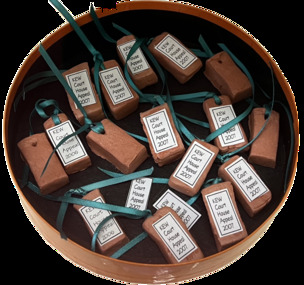
Souvenir - Miniature terracotta bricks, 2007
... ...heritage campaigns...Save the Kew Court house Dioen mcintyre heritage campaigns Kew Court House -- 188 High Street -- Kew (Vic.) ...A civic campaign for new public offices developed in Kew in the 1880s. After much deliberation, the location chosen was the junction of Bulleen and Cotham Roads. The buildings were designed by George Watson and John Henry Harvey, architects within the Department of Public Works (Victoria). Building was commenced in 1887, and after one year, the buildings were opened. The Post Office was transferred to the new Commonwealth Government in 1901. The Police Station and Court House, sold by the Victorian Government to the City of Boroondara in 2007, are now a community cultural centre and performing arts venue.The buildings were listed on the Victorian Heritage Register Register (HO885) in 1991. They are historically and architecturally significant to the State of Victoria because Watson and Harvey's designs exhibit diversity in integrating civil offices, they accommodate the apex of road junctions, and they demonstrate a departure from the contemporaneously favoured High Victorian Classical to the Queen Anne style in the design of civic buildings.Small collection of miniature terracotta bricks created to sell in order to raise funds for the 'Save the Kew Court House' campaign. Dione McIntyre who led the campaign conceived and made the bricks. The oblong bricks were pierced and pieces of green ribbon were threaded through each hole. Each brick had a printed label."Kew Court House Appeal 2007"save the kew court house, dioen mcintyre, heritage campaigns, kew court house -- 188 high street -- kew (vic.) -
Broadmeadows Historical Society & Museum
Book - Community History, Elaine V Brogan OAM, Fifty years 1969-2019: History of the Western Metropolitan group of Historical Societies, 2019
... Through joint exhibitions, newsletters, seminars, and heritage campaigns, the Group fostered a sense of shared purpose and regional identity. ...Through joint exhibitions, newsletters, seminars, and heritage campaigns, the Group fostered a sense of shared purpose and regional identity. ...Fifty Years of the WMGHS, from 196948-page white book with stapled card coversnon-fictionFifty Years of the WMGHS, from 1969western metropolitan group of historical societies, 1969, 2019, elaine v. brogan oam -
 Surrey Hills Historical Society Collection
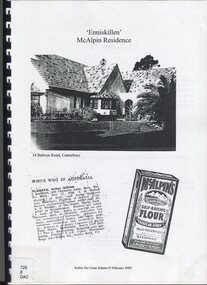
Book, Robin Da Costa-Adams, Enniskillen McAlpin Residence, Feb-09
... Robin da Costa-Adams has researched and written many publications including 'Blackburn a picturesque history, 1978'; 'Land of Gold: Gwlad yr Aur: James Tipping and a Mining Heritage'; 'Address (with signatories) from the women of Ballarat & Ballarat East to the women of England 1864 : against transportation of convicts', compiled and indexed by Robin; and 'Connie's Story : commemorating the Life of Mrs Edward (Plorn) Dickens'. Robin has been a tireless campaigner...Robin da Costa-Adams has researched and written many publications including 'Blackburn a picturesque history, 1978'; 'Land of Gold: Gwlad yr Aur: James Tipping and a Mining Heritage'; 'Address (with signatories) from the women of Ballarat & Ballarat East to the women of England 1864 : against transportation of convicts', compiled and indexed by Robin; and 'Connie's Story : commemorating the Life of Mrs Edward (Plorn) Dickens'. Robin has been a tireless campaigner ...This report was prepared by historian Robin da Costa-Adams to assess the cultural heritage significance of "Enniskillen" at 14 Balwyn Road, Canterbury. It includes some family history on a number of prominent families - the McAlpin family, the Hindson family and the architect, Arthur William Plaisted who designed 'Enniskillen' for the McAlpin family. McAlpin's was a major Victorian flour company in the nineteenth and early twentieth centuries. Owned and operated by J. McAlpin and Sons, the company sold its flour products across Australia and overseas. McAlpin's developed a successful marketing campaign which was pitched directly at housewives. One innovation was the publishing of a free cookbook which had recipes in it that used McAlpin's products. These free cookbooks were published successively from the 1930s through to the 1960s in Australia. Arthur Plaisted also designed the Surrey Hills Medical Centre in Union Road c1911. Some of his work is featured on the State Library of Victoria Collection. Robin da Costa-Adams has researched and written many publications including 'Blackburn a picturesque history, 1978'; 'Land of Gold: Gwlad yr Aur: James Tipping and a Mining Heritage'; 'Address (with signatories) from the women of Ballarat & Ballarat East to the women of England 1864 : against transportation of convicts', compiled and indexed by Robin; and 'Connie's Story : commemorating the Life of Mrs Edward (Plorn) Dickens'. Robin has been a tireless campaigner for heritage protection in Canterbury. This document on 'Enniskillen' was included with Robin's submission for 2 VCAT hearings regarding possible development of the property. Both resulted in a judgement against the proposed developments. In the recent (2021) hearing the document was specifically mentioned in the judgement.A report prepared by Robin da Costa-Adams in 2009 to assess the cultural heritage significance of "Enniskillen" at 14 Balwyn Road, Canterbury. It includes some family history on the McAlpin family, the Hindson family and the architect Arthur WIlliam Plaisted family.(mr) arthur plaisted, (mr) walter plaisted, enniskillen, shrublands, house names, (mr) francis henty, (mrs) mary henty, (mr) ernest carter, heathfield, (mr) john hindson, (mrs) alice hindson, (mr) william hindson, (mrs) annie west mcalpin, (mr) john mcalpin, mcalpin bakery, (mr) keith matthies, dental surgeon, (mr) william wolf, architects, (miss) mary beacon, robin ca costa-adams -
 Emerald Museum & Nobelius Heritage Park
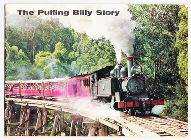
Booklet - Puffing Billy booklet, Puffing Billy Preservation Society, 'The Puffing Billy Story', 1960s
... Emerald Museum & Nobelius Heritage Park 5 Crichton Rd Emerald yarra-valley-and-the-dandenong-ranges This booklet recounts the story of Puffing Billy's inception in 1900; the landslide in 1952 which led to closure in 1958; the public campaign for re-opening of the line; a partial reopening in 1962 followed by a return to Emerald Station in 1965. ...This booklet recounts the story of Puffing Billy's inception in 1900; the landslide in 1952 which led to closure in 1958; the public campaign for re-opening of the line; a partial reopening in 1962 followed by a return to Emerald Station in 1965. It also discusses the history and role of the Puffing Billy Presentation Society which produced this booklet c. 1960s.This booklet recounts the history of a Victorian tourist icon, Puffing Billy.Paperback booklet entitled 'The Puffing Billy Story'. Color front photograph with black and white photographs inside. 18 pages.On the front printed: 'THE PUFFING BILLY STORY' On the back printed: 'The / Good Old / Days / Engine 8A on the Gembrook / car-goods train at the / water tank between Selby / and Menzie's Creek. /The landslide which was / responsible for the / closing of the line in 1953 / occurred near this spot.'puffing billy, puffing billy presentation society, 1960s -
 Emerald Museum & Nobelius Heritage Park
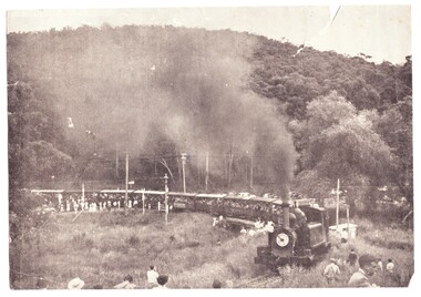
Photograph - Photograph of Puffing Billy, 1950s
... Emerald Museum & Nobelius Heritage Park 5 Crichton Rd Emerald yarra-valley-and-the-dandenong-ranges Puffing Billy was scheduled to be closed by the Victorian Government following falling passenger numbers and a landslide near Menzies Creek. This photograph is believed to have been taken on one of three special days in December 1954 and January 1955 negotiated by the Herald and Weekly Times for its 'Young Sun' readers before the line was permanently closed. A public campaign ...Puffing Billy was scheduled to be closed by the Victorian Government following falling passenger numbers and a landslide near Menzies Creek. This photograph is believed to have been taken on one of three special days in December 1954 and January 1955 negotiated by the Herald and Weekly Times for its 'Young Sun' readers before the line was permanently closed. A public campaign to reopen the line ensued. This photo is taken of the train crossing the road at Upper Ferntree gully. At that time, there was no railway bridge to separate the crossing from the road.Black and white photograph of Puffing Billy train crossing the road at Upper Ferntree Gully towards Belgrave c. December 1954 - the train is packed with passengers and with many well-wishers standing on the tracks.puffing billy, herald and weekly times, young sun, upper ferntree gully -
 Lara RSL Sub Branch
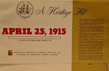
Education Kit - A Heritage Kit, THE ANZAC BATTLEFIELD, Published by Southdown Press Pty Ltd Melbourne in 1964
... A Heritage Kit, APRIL 25,1915. The Australian and New Zealand campaign on Gallipoli in 1915....Rectangular shaped folder containing information and pictures of the Gallipoli campaign. THE ANZAC BATTLEFIELD Education Kit A Heritage Kit. ...The Gallipoli campaign, also known as the Dardanelles campaign, the Battle of Gallipoli or the Battle of Çanakkale, was a campaign of the First World War that took place on the Gallipoli peninsula, from 17 February 1915 to 9 January 1916. Rectangular shaped folder containing information and pictures of the Gallipoli campaign.A Heritage Kit, APRIL 25,1915. The Australian and New Zealand campaign on Gallipoli in 1915.how it looked, battle maps, leaders and vcs, relics, photographs, the soldiers, the news, the men of anzac, the battleground, why gallipoli was fought, the first aif, the landing, the campaign, the new zealanders -
 Mission to Seafarers Victoria
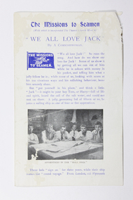
Booklet - Loose newsletter page, We all Love Jack, early 20th Century
... campaigned to stamp this practice out. The title " we all love Jack" drawn from a popular song of the time. A useful rare visual reference for the Heritage archive at MtSV as it depicts Apprentices in a typical half deck quarters of the early 20th C. with newspapers and books, some of which may have been provided by an MtS. apprentices jacks ashore Page from a Mission newsletter, Heading: The Missions to Seamen with which is incorporated the Thames Church Mission. ...The page seems to be the opening paragraphs of an article describing the young apprentice seamen experience and system and attempting to defuse misconceptions and perceptions of rollicking but also vulnerable young "Jacks ashore" with money in their pockets. A long standing practice of 'crimping' a sailor's earnings, targeted by the Missions throughout the 19th and early 20th Century they campaigned to stamp this practice out. The title " we all love Jack" drawn from a popular song of the time.A useful rare visual reference for the Heritage archive at MtSV as it depicts Apprentices in a typical half deck quarters of the early 20th C. with newspapers and books, some of which may have been provided by an MtS.Page from a Mission newsletter, Heading: The Missions to Seamen with which is incorporated the Thames Church Mission. "We All Love Jack" / By a Cornishwoman / a Flying Angel flag of the Missions to Seamen heads the first paragraph. A black and white photograph of six "Apprentices in the half deck" is positioned after the 2nd paragraph. apprentices, jacks ashore -
 Eltham District Historical Society Inc
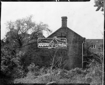
Photograph, Side view of Shillinglaw Cottage
... campaign saved the cottage and it was re-located. Shillinglaw Cottage is itself historically, aesthetically and socially significant to the Shire of Nillumbik and is registered on the Victorian Heritage Database. ...Side view of 'Shillllinglaw Cottage' in its original location on Main Road Eltham, 1964. The cottage was built by George Stebbings about 1859 and is made from hand made bricks laid in a Flemish bond pattern. In the 1960s it was marked for demolition to make way for the construction of new council buildings but a community campaign saved the cottage and it was re-located.Shillinglaw Cottage is itself historically, aesthetically and socially significant to the Shire of Nillumbik and is registered on the Victorian Heritage Database. This photo forms part of a collection of photographs gathered by the Shire of Eltham for their centenary project book, "Pioneers and Painters: 100 years of the Shire of Eltham" by Alan Marshall (1971). The collection of over 500 images is held in partnership between Eltham District Historical Society and Yarra Plenty Regional Library (Eltham Library) and is now formally known as 'The Shire of Eltham Pioneers Photograph Collection.' It is significant in being the first community sourced collection representing the places and people of the Shire's first one hundred years.Digital imagesepp, shire of eltham pioneers photograph collection, eltham, shillinglaw cottage -
 Bendigo Historical Society Inc.
Ephemera - White Hills Swimming Pool Scrapbook, 1963
... Heritage Register in 2001. White Hills Swimming Pool Scrapbook Pool Committee Written on the front cover "T J Randles" and "Part 2". Thelma Randles Collection. Red and white scrapbook containing photographs, newspaper cuttings, handwrittten notes, typed documents, letters. Most items are dated with some labels. Most items have been attached with adhesive tape. First item dated February 1963 and last item dated November 1985. The scrapbook documents the campaign ...As early as 1947 there was a request to have a swimming pool in the White Hills Botanic Gardens, and while the proposal was rejected by Council for many years, continued lobbying from the local community eventually saw it approved. The land had originally been reserved for botanic garden purposes only and it was required to be re-reserved for botanic and recreation purposes, to allow a different use. By 1956 the land was officially re-gazetted, excavation started in 1957 and the pool was completed by 1959. The gardens, in which the pool is situated, is one of the earliest botanic gardens in regional Victoria. It was included on the Victorian Heritage Register in 2001. Thelma Randles Collection. Red and white scrapbook containing photographs, newspaper cuttings, handwrittten notes, typed documents, letters. Most items are dated with some labels. Most items have been attached with adhesive tape. First item dated February 1963 and last item dated November 1985. The scrapbook documents the campaign to build a swimming pool at White Hills. Thelma Randles was a member of the Pool Committee for many years.Written on the front cover "T J Randles" and "Part 2".white hills swimming pool, scrapbook, pool committee -
Port Melbourne Historical & Preservation Society
Flyer - Promotional material from Mission Arts Centre, 1988
... Material relating to a campaign to save the Missions to Seamen building, 1987-88: items relating to an open day at the Missions to Seamen building for Heritage Week, 22 to 25 April 1988, including notes for accompanying guided tour...campaign waged to save the building from demolition. It was demolished in October 1995. Mission to Seamen Arts and Entertainment Mission Arts Centre National Trust of Victoria Harry A NORRIS Pat GRAINGER Barry MERAT Brian COULDREY Town Planning Heritage Material relating to a campaign to save the Missions to Seamen building, 1987-88: items relating to an open day at the Missions to Seamen building for Heritage Week, 22 to 25 April 1988, including notes for accompanying guided tour Flyer Promotional material from Mission Arts Centre ...The Missions to Seamen building, designed by architect Harry Norris and built in 1937, was located on the site proposed 50 years later for development by the Sandridge Development Company. The building fell into disrepair after it was closed by the church in 1972, but enjoyed a brief and energetic period in 1987-90 when it was used as a community arts centre. These documents record the campaign waged to save the building from demolition. It was demolished in October 1995.Material relating to a campaign to save the Missions to Seamen building, 1987-88: items relating to an open day at the Missions to Seamen building for Heritage Week, 22 to 25 April 1988, including notes for accompanying guided tourmission to seamen, arts and entertainment, mission arts centre, national trust of victoria, harry a norris, pat grainger, barry merat, brian couldrey, town planning, heritage -
 Bendigo Historical Society Inc.
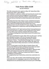
Document - PETER ELLIS COLLECTION: PETER ELLIS EULOGY
... heritage with its matching six CD collection. Peter has also contributed to 'Verandah Music' edited by Rob Willis and Graham Seal and 'The Oxford Companion to Australian Folklore' edited by Graham Seal and is a regular contributor to Trad & Now. He completed his last Trad & Now article the week before he died. Peter was also a life member of the Field Naturalists and was extremely active in campaigns...heritage with its matching six CD collection. Peter has also contributed to 'Verandah Music' edited by Rob Willis and Graham Seal and 'The Oxford Companion to Australian Folklore' edited by Graham Seal and is a regular contributor to Trad & Now. He completed his last Trad & Now article the week before he died. Peter was also a life member of the Field Naturalists and was extremely active in campaigns ...2 A4 sheets. Handwritten pencil note at top of first page reads: Eulogy published in Trad & Now Magazine. Vale Peter Ellis OAM. By John Williams. The folk community lost a giant on May 18th when Peter Ellis passed away after a short illness. Peter had been a collector, author and musician for nearly forty years and his work has been prodigious to say the least. Peter has the largest collection of dance related material in the National Library and had travelled Australia on his collection trips. He produced twenty CDs of dance music and historical music with his Bendigo based band the Celebrated Emu Creek Bush Band which he founded and led for thirty four years. His final project was the double CD 'Cooee, Songs of the ANZACS' which he organised in conjunction with the Bendigo Historical Society. It was launched on 24th April and was Peter's last performance. Peter has also been a member of the Wedderburn Old Timers for over thirty years and has assisted with many of their recordings including their latest Bush Concert CD which Peter Organised. Peter has contributed to many other CDs over the years and has been thanked on many a CD cover by many folk artists. Peter has also written several books, the three volume 'Collectors' Choice,' 'Two Hundred Dancing Years' co-written with Shirley Andrews OAM, and 'Music Makes Me Smile' the history of the Nariel Valley musicians co-written with Harry Gardner. Peter's recent major work The Merry Country Dance will become the bible for people wishing to learn about our bush music heritage with its matching six CD collection. Peter has also contributed to 'Verandah Music' edited by Rob Willis and Graham Seal and 'The Oxford Companion to Australian Folklore' edited by Graham Seal and is a regular contributor to Trad & Now. He completed his last Trad & Now article the week before he died. Peter was also a life member of the Field Naturalists and was extremely active in campaigns to preserve Lake Pedder, the Whipstick Forest and Kamarooka Forest (now part of Bendigo National Park and preserved forever) One Tree Hill, Jackass Flat Flora Reserve and Saloman's Gully bushlands. Peter has discovered and named plants in the whipstick and enjoyed propagating native plants. He loved his amazing bush block in suburban Bendigo. Peter was also a keen photographer and had photos published in the book 'Wildflowers of Bendigo'. Peter taught dancing and music classes with Continuing Education for many years and encouraged many young musicians over the years. Peter was an accomplished ballroom dancer and had achieved gold medal status in that field. He was one of Australia's finest exponents of the button accordion, concertina, harmonica and tin whistle. Peter also played piano, organ and ukulele as well as the Swanee whistle and bones. Peter was the founder of the Annual Dinki Di Ball held each September in Eaglehawk as a tribute to the old MC's. Peter was happy playing for fund-raisers for any organisation who asked and also enjoyed plying the big gigs such as for the opening of the Melbourne Museum or for State Parliament. He played in the National Folk Festivals in four states and was a regular at the National in Canberra where he gave regular classes, performed with his bands and was a stalwart of the Aussie section of the session bar. He performed at nearly every Maldon Folk Festival and was MC at Nariel Folk Festival dances for many years. Peter was very proud of his OAM and wore the little medal at all of his performances. That honour was rightly given to one who did so much to preserve Australia's dance history. Peter lived a full life and was a friend to hundreds of people. He was taken far too young and in typical fashion was planning new projects right till the end. His passing is a huge loss for us all but one thing is certain. He will never be forgotten.person, individual, peter ellis oam -
 Bendigo Historical Society Inc.
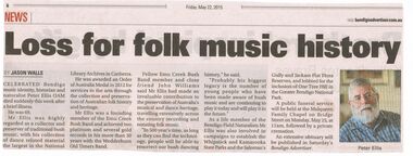
Newspaper - PETER ELLIS COLLECTION: NEWSPAPER ARTICLE, 22nd May, 2015
... heritage, travelling extensively across the country recording and notating folk music. 'In 500 year's time, as long as they can find the technology, people will be able to resurrect our bush dancing history,' he said. 'Probably his biggest legacy is the number of young people who have been made aware of bush music and are continuing to play it today and will play it in the future.' As a life member of the Bendigo Field Naturalists Mr Ellis was also involved in campaigns...heritage, travelling extensively across the country recording and notating folk music. 'In 500 year's time, as long as they can find the technology, people will be able to resurrect our bush dancing history,' he said. 'Probably his biggest legacy is the number of young people who have been made aware of bush music and are continuing to play it today and will play it in the future.' As a life member of the Bendigo Field Naturalists Mr Ellis was also involved in campaigns ...Newspaper article from the Bendigo Advertiser stuck on A4 printer paper. Article is dated Friday, May 22, 2015. Article is accompanied by a picture of Peter Ellis and is captioned as such. Article is written by Jason Walls and is titled Loss for folk music history. Article reads: Celebrated Bendigo Music identity, historian and naturalist Peter Ellis OAM died suddenly this week after a brief illness. He was 69. Mr Ellis was highly regarded as a collector and preserver of traditional bush music, with his collection of dance related material the largest in the National Library Archives in Canberra. He was award an Order of Australia Medal in 2012 for services to the arts through the collection and preservation of Australian folk history and heritage. Mr Ellis was a founding member of the Emu Creek Bush Band and achieved two platinum and several gold records in his more than 30 years with the Wedderburn Old Timers Band. Fellow Emu Creek Bush Band member and close friend John Williams said Mr Ellis had made an invaluable contribution to the preservation of Australia's musical and dance heritage, travelling extensively across the country recording and notating folk music. 'In 500 year's time, as long as they can find the technology, people will be able to resurrect our bush dancing history,' he said. 'Probably his biggest legacy is the number of young people who have been made aware of bush music and are continuing to play it today and will play it in the future.' As a life member of the Bendigo Field Naturalists Mr Ellis was also involved in campaigns to establish the Whipstick and Kamarooka State Parks and the Saloman's Gully and Jackass Flat Flora Reserves, and lobbied for the inclusion of One Tree Hill in the Greater Bendigo National Park. A public funeral service will beheld at the Mulqueen Family Chapel on Bridge Street on Monday, May 25, at 11am, followed by a private cremation. An extensive obituary will be published in Saturday's Bendigo Advertiser.person, individual, peter ellis oam -
 Flagstaff Hill Maritime Museum and Village
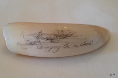
Craft - Scrimshaw, Bringing in the Whale
... He is the founder of the Albany Maritime Heritage Association and was the inaugural President. In the 1990s he actively and successfully campaigned for the preservation of the Cheynes Beach Whaling Station in Albany, which is now Whale World, an open-air whaling museum. ...He is the founder of the Albany Maritime Heritage Association and was the inaugural President. In the 1990s he actively and successfully campaigned for the preservation of the Cheynes Beach Whaling Station in Albany, which is now Whale World, an open-air whaling museum. ...When scrimshaw is mentioned, most people think of carving on sperm whale teeth only. But scrimshaw also includes engravings on skeletal whale bone–such as the jaw bone, called pan bone and ivory from other marine mammals such as walrus. Although scrimshaw is widely associated with nautical themes and designs of the 19th century whaling industry, vintage scrimshaw was also produced as tribal art in many cultures. Today, scrimshaw is recognized as a unique medium in which present-day artists have developed their own modern themes. Scrimshaw reproductions may take several forms. There are - New carvings on genuine ivory or bone with the deliberate intent to create an "antique” - New carvings on genuine ivory or bone sold as signed and dated contemporary art - Clearly marked synthetic museum reproductions and mass marketed - Unmarked synthetic replicas This scrimshaw work is done on a sperm whale's tooth. It is one of two pieces by artist Gary Tonkin in Flagstaff Hill’s collection. Sperm whales can live for 60 or even 70 years, so the tooth could be quite old. It came from the whaling station in Albany, Western Australia, which ceased processing whales in 1978 and is now a whaling museum. The two works were commissioned by Flagstaff Hill in the 1980s. Tonkin could spend from a few days to a few months in intensive work on each piece of scrimshaw. He is a world-renowned Master Scrimshander and a Fellow of the Australian Society of Marine Artists (FASMA), and lives in Albany, Western Australia. Gary Tonkin, FASMA – Tonkin was born in 1949 in Portland, Victoria, and grew up there with a history of whaling and related industries. He moved to Albany in southwest WA in 1971 and worked as an Export Meat inspector for the Federal Government. This small town also had a historical connection to whaling. The Cheynes Beach Whaling Station was still operating, and there were even three whaling ‘chaser’ vessels at the old jetty. In 1975, his employment now permanent, Tonkin bought an old cottage near the bay, purchased some whales’ teeth, and began learning the sailors’ art of scrimshaw, combining this with his artistic skills and knowledge of history. His job gave him access to buy as many whale teeth as he could afford, straight from the whaling station. Tonkin gained further marine knowledge as he sailed on the schooner ‘Esperance’ from Fremantle to Mauritius in 1988. He watched the sailors at work and experienced the rough and stormy sea conditions first-hand. Tonkin later visited whaling museums, galleries and libraries in England and America to gather reference materials and information on all aspects of whaling and scrimshaw. In 1993 he was Commissioned to engrave six large whale teeth, from the Albany whaling station, for the USA Gallery at the Australian National Maritime Museum in Sydney. This work is now in the museum’s permanent collection. From that time, Tonkin began working full-time as a Scrimshander. Tonkin’s work is now in galleries and museums in America and Australia, as well as in private collections. He is the founder of the Albany Maritime Heritage Association and was the inaugural President. In the 1990s he actively and successfully campaigned for the preservation of the Cheynes Beach Whaling Station in Albany, which is now Whale World, an open-air whaling museum. His continuing work as a Scrimshander contributes to the preservation of the art of scrimshaw and the history of whaling. This scrimshaw represents the ancient craft of scrimshaw, associated with mariners in the whaling trade in the early 19th century. The work is also Nationally significant for being created by world-renowned Scrimshander, Gary Tonkin, from Albany, Western Australia. Scrimshaw; whale tooth carved with an image of two whaleboats hauling a dead whale back to the mother ship. Inscribed Title and signature of artist Gary Tonkin.Inscribed "Bringing in the whale". Signature "G Tonkin"flagstaff hill maritime museum and village, warrnambool, great ocean road, shipwreck coast, maritime museum, flagstaff hill, perth, whaling, whales, australia, scrimshaw, scrimshander, gary tonkin, g tonkin, bone, tooth, craft, albany, western australia, cheynes beach whaling station, whale world, portland, engraving, maritime art, sperm whale's tooth, albany whaling station, albany whaling museum -
 Federation University Historical Collection
Letter - Correspondence, S.C. McBride, Letter concerning the work of Pastor Doug Nicholls and the Aborigines Advancement League, 1958, 11/07/1958
... heritage, and is based in Melbourne. The League was established in 1957 as a response to an enquiry by retired magistrate, Charles McLean, into the circumstances of Aboriginal Victorians. McLean was critical of conditions in the Lake Tyers and Framlingham Aboriginal Reserves. McLean recommended that persons of mixed Aboriginal and European descent be removed from the reserves. The people of Lake Tyers objected to this, and the League was formed out of their campaign...heritage, and is based in Melbourne. The League was established in 1957 as a response to an enquiry by retired magistrate, Charles McLean, into the circumstances of Aboriginal Victorians. McLean was critical of conditions in the Lake Tyers and Framlingham Aboriginal Reserves. McLean recommended that persons of mixed Aboriginal and European descent be removed from the reserves. The people of Lake Tyers objected to this, and the League was formed out of their campaign ...The Church Men's Society was a part of the Church of Christ in Peel Street, Ballarat. In 1958 the President was C. Thomas, and S.C. McBride was Secretary. The Aborigines Advancement League (also known as the Aboriginal Advancement League) claims to be the oldest Aboriginal organisation in Australia. It is primarily concerned with Aboriginal welfare issues and the preservation of Aboriginal culture and heritage, and is based in Melbourne. The League was established in 1957 as a response to an enquiry by retired magistrate, Charles McLean, into the circumstances of Aboriginal Victorians. McLean was critical of conditions in the Lake Tyers and Framlingham Aboriginal Reserves. McLean recommended that persons of mixed Aboriginal and European descent be removed from the reserves. The people of Lake Tyers objected to this, and the League was formed out of their campaign. The new League drew from two already existing organisations, the Australian Aborigines League, established 1934 and the Save the Aborigines Committee, which had been established in 1955 as a response to the Warburton Ranges crisis. Founding President of the League was Gordon Bryant, with Doris Blackburn as Deputy President, Stan Davey as Secretary and Douglas Nicholls as Field Officer. Early activities included lobbying for a referendum to change the Australian constitution to allow the Federal government to legislate on Aboriginal affairs, and an establishing a legal defence fund for Albert Namatjira, after he was charged with supplying liquor to an Aboriginal ward.[1] By 1967 it had moved to being fully controlled by Aboriginal people with Bill Onus as the first Aboriginal President.Typed letter on Church Men's Society (C.M.S.) letterhead. The letter concerns a film 'showing the tragic condition of aborigines in Central Western Australia ...' The C.M.S. (Ballarat) planned to hold a public meeting in Ballarat at which Pastor Doug Nicholls, M.B.E. will speak and screen the film. doug nicholls, c. thomas, aborigines, ballarat town hall, stan davey, s.c. mcbride, letterhead -
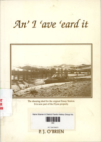 Narre Warren and District Family History Group
Book, Pat J O'Brien, An' I 'ave 'eard it, 1996
... campaign from 1983-86, he served two terms on the Shire of Traralgon, becoming president in 1990. In 1959, Pat married Ann Smyth whose forebears, the O'Rourkes, moved from the Monaro in New South Wales to Gelantipy in the 1830's. So they are both true-blue Gippslanders. They have seven children and nine grandchildren to date and now live in Merimbula. Conscious that much of the history of his family, neighbours and friends is being lost, he wrote this book because he believes that the stories and characters mentioned are part of our heritage ...In 1877 John O'Brien selected Negoura at Swifts Creek, and the O'Brien name has been prominent and well-known in the district since. Pat O'Brien is the third son of John's eldest grandson, Jack (dec) and Clare O'Brien, who have farmed at "Fernlea", Ensay since 1948. He grew up and went to school in Ensay and then to boarding school at St Patrick's College, Sale. From 1952 to 1965, he worked in the Ensay district as a shearer, contract fencer and general farm hand. He was actively involved in community affairs becoming president of the Ensay Tennis Club for three years and was a foundation member of the Ensay Bowling Club. For 14 years he played for the Ensay Football team and for seven of those years was a delegate to the Omeo District Football League. After leaving Ensay in 1965 he spent two years in Bairnsdale before moving to Morwell and later Traralgon in the Latrobe Valley. After leading the highly successful Save our Shire campaign from 1983-86, he served two terms on the Shire of Traralgon, becoming president in 1990. In 1959, Pat married Ann Smyth whose forebears, the O'Rourkes, moved from the Monaro in New South Wales to Gelantipy in the 1830's. So they are both true-blue Gippslanders. They have seven children and nine grandchildren to date and now live in Merimbula. Conscious that much of the history of his family, neighbours and friends is being lost, he wrote this book because he believes that the stories and characters mentioned are part of our heritage and should not be forgotten. (Back cover)non-fictionIn 1877 John O'Brien selected Negoura at Swifts Creek, and the O'Brien name has been prominent and well-known in the district since. Pat O'Brien is the third son of John's eldest grandson, Jack (dec) and Clare O'Brien, who have farmed at "Fernlea", Ensay since 1948. He grew up and went to school in Ensay and then to boarding school at St Patrick's College, Sale. From 1952 to 1965, he worked in the Ensay district as a shearer, contract fencer and general farm hand. He was actively involved in community affairs becoming president of the Ensay Tennis Club for three years and was a foundation member of the Ensay Bowling Club. For 14 years he played for the Ensay Football team and for seven of those years was a delegate to the Omeo District Football League. After leaving Ensay in 1965 he spent two years in Bairnsdale before moving to Morwell and later Traralgon in the Latrobe Valley. After leading the highly successful Save our Shire campaign from 1983-86, he served two terms on the Shire of Traralgon, becoming president in 1990. In 1959, Pat married Ann Smyth whose forebears, the O'Rourkes, moved from the Monaro in New South Wales to Gelantipy in the 1830's. So they are both true-blue Gippslanders. They have seven children and nine grandchildren to date and now live in Merimbula. Conscious that much of the history of his family, neighbours and friends is being lost, he wrote this book because he believes that the stories and characters mentioned are part of our heritage and should not be forgotten. (Back cover)gippsland region (vic.) -- history, biography, ensay station, swifts creek (vic.) -
Healesville Sanctuary Heritage Centre
Newspaper - Cutting, The Healesville Guardian, Sir Colin MacKenzie Sanctuary, 4 February 1955
... Healesville Sanctuary Heritage Centre 1950s Numbers of visitors to Sanctuary increasing. The campaign against vandalism has been quite successful. ...Numbers of visitors to Sanctuary increasing. The campaign against vandalism has been quite successful.Photocopynon-fictionNumbers of visitors to Sanctuary increasing. The campaign against vandalism has been quite successful.1950s -
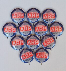 Sunshine and District Historical Society Incorporated
Memorabilia - Air Raid Precautions (ARP) badges, Circa early 1940's
... Heritage 'Air Raid Protection Services (ARP)' publication, or the image of a badge offered for sale on ebay. At this stage we are uncertain of why this is so. If anybody knows the answer then please leave a message on this site. During World War 2 Australian municipalities were expected to take precautions against air raids, with the Government campaigning...Heritage 'Air Raid Protection Services (ARP)' publication, or the image of a badge offered for sale on ebay. At this stage we are uncertain of why this is so. If anybody knows the answer then please leave a message on this site. During World War 2 Australian municipalities were expected to take precautions against air raids, with the Government campaigning ...Mr Webb King was an Air Raid Warden during World War 2. These badges were found when his workshop was being cleared out, and so were donated to our society. The badges in our possession do not have the word WARDEN printed on them, like the image of the badge shown on the Darebin Heritage 'Air Raid Protection Services (ARP)' publication, or the image of a badge offered for sale on ebay. At this stage we are uncertain of why this is so. If anybody knows the answer then please leave a message on this site. During World War 2 Australian municipalities were expected to take precautions against air raids, with the Government campaigning to recruit men over 45 to be volunteer Air Raid Wardens. It was also common for women to become wardens. Wardens carried gas masks, helmets, and rattles or whistles. The wardens received 7 to 8 one hour sessions of training, and their chief duty was to advise people of precautions to take, and to ensure those precautions were taken. Air Raid Precautions included air raid drills, shelters (usually trenches), first aid, fire fighting, rescue of 'gassed' persons, evacuation drills, demolition and repair squads, monitoring of blackouts. Melbourne was deemed vulnerable to aerial attack because of its centralised port and industrial facilities and so Anti-aircraft guns were installed in Maribyrnong. By early 1942 more than 60,000 people voluntarily carried out Air Raid Precautions duties according to the Autobiography of Robert V. J. Padula OAM. As the threat diminished during 1943 and 1944 the need for air raid precautions was slowly reduced, and some shelters (trenches) were filled. The two photos showing Air Raid Wardens are out of copyright and have been sourced from the 'Argus Newspaper Collection of Photographs, State Library of Victoria.' The image showing one warden on Swanston Street Melbourne has been cropped to remove extras not connected with the photo. Other sources of information for this report are: (1) http://bpadula.tripod.com/autobiography/id100.html, (2) https://www.awm.gov.au/exhibitions/underattack/mobilise/precautions.asp, (3) http://heritage.darebinlibraries.vic.gov.au/article/57. The ARP badges are a historic reminder of the precautions that were taken in Victoria during the early years of World War 2. The precautions were an effort to minimise the harmful effects of a theoretical air raid. The war started to turn and so an air raid never came, however many people received valuable training in what precautions needed to be taken.Pressed metal round badges with pins. Main feature of badges is the large whitish lettering ARP on a red background. A black outlined crown and the word VICTORIA in red on whitish background is also on the badges. At the bottom of the badges in black are the letters DC plus the numbers of the badges.Serial Numbers of the badges are: DC 361, DC 362, DC 364, DC 368, DC 370, DC 374, DC 375, DC 376, DC 377, DC 379, DC 388, DC 389.arp. arp badge, air raid precautions, air raid precautions warden, warden, badges -
 Merri-bek City Council
Work on paper - Charcoal and pages from Aboriginal Words and Place Names, Jenna Lee, Without us, 2022
... heritage, and to address the dispossession and dislocation of Aboriginal and Torres Strait Islander peoples from their lands. The proposed acquisitions confront the erasure of Indigenous languages as a consequence of colonisation; as such, their inclusion in the Merri-bek Art Collection demonstrates Council’s commitment to support campaigns for Aboriginal and Torres Strait Islander people’s rights, especially to language. ...Jenna Lee dissects and reconstructs colonial 'Indigenous dictionaries' and embeds the works with new cultural meaning. Long obsessed with the duality of the destructive and healing properties that fire can yield, this element has been applied to the paper in the forms of burning and mark-making. In Without Us, Lee uses charcoal to conceal the text on the page, viewing this process as a ritualistic act of reclaiming and honouring Indigenous heritage while challenging the oppressive legacies of colonialism. Lee explains in Art Guide (2022), ‘These books in particular [used to create the proposed works] are Aboriginal language dictionaries—but there’s no such thing as “Aboriginal language”. There are hundreds of languages. The dictionary just presents words, with no reference to where they came from. It was specifically published by collating compendiums from the 1920s, 30s and 40s, with the purpose to give [non-Indigenous] people pleasant sounding Aboriginal words to name children, houses and boats. And yet the first things that were taken from us was our language, children, land and water. And the reason our words were so widely written down was because [white Australians] were trying to eradicate us. They thought we were going extinct. The deeper you get into it, the darker it gets. But the purpose of my work is to take those horrible things and cast them as something beautiful.’Framed artwork -
 Brunswick Community History Group
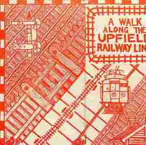
Archive - Upfield Railway Line
... Heritage Study by Andrew Ward (1990) can be found on the Merri-bek Council website. / The Lonie Report prepared by the State Government in 1988 recommended conversion of all or part of the line to light rail. Some proposals involved replacing the Sydney Road trams with light rail, freeing up the rail reservation for a freeway, while others proposed installing the light rail on the rail reservation from Upfield to Park Street, where the line would divert to join the Royal Parade tram line. / Our collection includes documents on the community campaign to save the line from the Cain Government in 1989-90 and the Kennett Government in 1992-93. ...Heritage Study by Andrew Ward (1990) can be found on the Merri-bek Council website. The Lonie Report prepared by the State Government in 1988 recommended conversion of all or part of the line to light rail. Some proposals involved replacing the Sydney Road trams with light rail, freeing up the rail reservation for a freeway, while others proposed installing the light rail on the rail reservation from Upfield to Park Street, where the line would divert to join the Royal Parade tram line. Our collection includes documents on the community campaign..."Rail Services Upfield Railway Line community campaigns" Our collection includes a number of documents on the history of the line including a film Heritage on the Line produced in 1992 and Down the line to Upfield by Jon Saul and Wendy Moore. 3rd edition 1994 and Northern Suburbs Transport Plan prepared by the Upgrade Upfield Coordinating Committee 1994. ...Our collection includes a number of documents on the history of the line including a film Heritage on the Line produced in 1992 and Down the line to Upfield by Jon Saul and Wendy Moore. 3rd edition 1994 and Northern Suburbs Transport Plan prepared by the Upgrade Upfield Coordinating Committee 1994. / The Upfield Line Heritage Study by Andrew Ward (1990) can be found on the Merri-bek Council website. / The Lonie Report prepared by the State Government in 1988 recommended conversion of all or part of the line to light rail. Some proposals involved replacing the Sydney Road trams with light rail, freeing up the rail reservation for a freeway, while others proposed installing the light rail on the rail reservation from Upfield to Park Street, where the line would divert to join the Royal Parade tram line. / Our collection includes documents on the community campaign to save the line from the Cain Government in 1989-90 and the Kennett Government in 1992-93. The Save the Upfield Line Campaign was set up and composed of local residents. We have a collection of their minutes and campaign materials. Brunswick Council was also actively involved in campaigning to save the line and set a Council and community committee to work on this. We also have minutes of its meetings and some Council reports on the issue. / In 1995 the State Government finally agreed to retain and upgrade the line. Our collection includes a number of documents on the history of the line including a film Heritage on the Line produced in 1992 and Down the line to Upfield by Jon Saul and Wendy Moore. 3rd edition 1994 and Northern Suburbs Transport Plan prepared by the Upgrade Upfield Coordinating Committee 1994. The Upfield Line Heritage Study by Andrew Ward (1990) can be found on the Merri-bek Council website. The Lonie Report prepared by the State Government in 1988 recommended conversion of all or part of the line to light rail. Some proposals involved replacing the Sydney Road trams with light rail, freeing up the rail reservation for a freeway, while others proposed installing the light rail on the rail reservation from Upfield to Park Street, where the line would divert to join the Royal Parade tram line. Our collection includes documents on the community campaign to save the line from the Cain Government in 1989-90 and the Kennett Government in 1992-93. The Save the Upfield Line Campaign was set up and composed of local residents. We have a collection of their minutes and campaign materials. Brunswick Council was also actively involved in campaigning to save the line and set a Council and community committee to work on this. We also have minutes of its meetings and some Council reports on the issue. In 1995 the State Government finally agreed to retain and upgrade the line. "rail services, upfield railway line, community campaigns" -
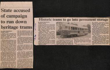 Melbourne Tram Museum
Newspaper, The Age, "State accused of campaign to run down heritage trams", "Historic trams to go into permanent storage", "Trust furious at plans to mothball old trams", 2/1992 to 4/1992
... "State accused of campaign to run down heritage trams", "Historic trams to go into permanent storage", "Trust furious at plans to mothball old trams"...Set of three Newspaper clippings written by Jacqui Macdonald, about the withdrawal and storage of W class trams. ,1 - The Age 11/2/1992 - titled "State accused of campaign to run down heritage trams", quotes Don Gibson Chairman of the Friends of the W class at the National Trust and Minister Peter Spyker. ..."State accused of campaign to run down heritage trams", "Historic trams to go into permanent storage", "Trust furious at plans to mothball old trams" Newspaper The Age Don Gibson, Peter Spyker, Alan Brown ...Set of three Newspaper clippings written by Jacqui Macdonald, about the withdrawal and storage of W class trams. ,1 - The Age 11/2/1992 - titled "State accused of campaign to run down heritage trams", quotes Don Gibson Chairman of the Friends of the W class at the National Trust and Minister Peter Spyker. Comments around the cost of maintenance. .2 - The Age 27-4-1992 - titled "Historic trams to go into permanent storage", includes a photo of SW5 758, to a North Melbourne warehouse in Alfred St, about 50 trams, without bogies, PTC spokesman said to secure storage. .3 - The Age 28/4/1992 - titled "Trust furious at plans to mothball old trams" - Quotes Don Gibson, not happy, more trams than needed, space issue, cost of overhauls, compared to new trams. Has a photo of Mr Brown, opposition transport spokesman, policy to keep as many as possible and run them.trams, tramways, w class, maintenance, national trust, withdrawn trams, stored trams, tram 758 -
 Sunshine and District Historical Society Incorporated
Archive - Gwen Goedecke Collection - Miscellaneous Topics
... Heritage and Environment, EPA and the MMBW|The Mt. Cottrell Project - project of the Western Region Commission - a final year thesis (1973)|Gwen's notes and photocopies of articles from a publication Melbourne's Development & Planning |Queen Victoria Hospital / Women's Centre - - newspaper clippings (1980's to 2000's) -correspondence, campaigns -a report by the Ministerial Advisory Committee (2000) |The Crow Collection Association - Ecosa Exchange Newsletters (80's and 90's) - Copies of extracts from Eureka Street, a Jesuit publication, with notations/comments from Ruth Crow (1993) -news articles, correspondence, phamplets, price lists, broad details of subject areas in the Crow Collection (1991) -report to the Committee of Management (1991) by Sheila Byard -article from the Australian Society (1985) on Ruth and Maurice Crow - Plan for Melbourne - parts 2&3 by Ruth and Maurice Crow (1972)...Heritage and Environment, EPA and the MMBW|The Mt. Cottrell Project - project of the Western Region Commission - a final year thesis (1973)|Gwen's notes and photocopies of articles from a publication Melbourne's Development & Planning |Queen Victoria Hospital / Women's Centre - - newspaper clippings (1980's to 2000's) -correspondence, campaigns -a report by the Ministerial Advisory Committee (2000) |The Crow Collection Association - Ecosa Exchange Newsletters (80's and 90's) - Copies of extracts from Eureka Street, a Jesuit publication, with notations/comments from Ruth Crow (1993) -news articles, correspondence, phamplets, price lists, broad details of subject areas in the Crow Collection (1991) -report to the Committee of Management (1991) by Sheila Byard -article from the Australian Society (1985) on Ruth and Maurice Crow - Plan for Melbourne - parts 2&3 by Ruth and Maurice Crow (1972) Documents, publications, directories, newspaper articles, corespondence Archive Gwen Goedecke Collection - Miscellaneous Topics ...Letter to Community Activists re Transport needs of Melbourne from the People for Environmentally Sustainable Transport (dated?)| Docklands Task Force - correspondence, information Bulletins on Docklands, Explore Docklands including history and map (all 1991) |Referendum on a Republic (flyer) - information regarding the referendum in 1999 by the Constitution Centenary Foundation |A Whole Year of Celebration (flyer) re Victoria turning 150 years old (1984) From Citzen to Councillor - A Guide for Prospective Councillors (3rd edition (1999) by the Municipal Association of Victoria | PUBLIC FIRST Campaign - a Coalition opposed to privatisation of public utilities - newsletter containing operating principles, organisational roles etc |Environment Victoria - Newspaper 52/53 Forestry in Victoria Western Suburbs Action - by the Conservation Council of Victoria (1984) |Police and Community Youth Clubs - report (1999) Managing Cultural Equity: The Philosophy, Politics and Institutional Behaviours |The Age souvenir pages Melbourne 150' (1992) |PUBLICATIONS|The Australin Municipal journal #64 (June 1985) by the Municipal Association of Victoria| Make Melbourne Marvellous - by the Socialist Alternative Melbourne Collective (The Sam Collective) 1985|Self Help Resource Directory - 2nd edition by a Collective of Self Help Groups (Victoria 1982)|Industrial Waste Project Information Kit (MMBW 1986)|Western Region Environment Commission Minutes July 1985 together with a copy of the Draft Industrial Waste Strategy for Victoria (1985) by the EPA|Interim Directory of Government Departments and Authorities VIC from the Department of the Premier (1979)|National strategies for Managing Hazardous Waste - Conference papers (1985) by the Commonwealth Department of Arts, Heritage and Environment, EPA and the MMBW|The Mt. Cottrell Project - project of the Western Region Commission - a final year thesis (1973)|Gwen's notes and photocopies of articles from a publication Melbourne's Development & Planning |Queen Victoria Hospital / Women's Centre - - newspaper clippings (1980's to 2000's) -correspondence, campaigns -a report by the Ministerial Advisory Committee (2000) |The Crow Collection Association - Ecosa Exchange Newsletters (80's and 90's) - Copies of extracts from Eureka Street, a Jesuit publication, with notations/comments from Ruth Crow (1993) -news articles, correspondence, phamplets, price lists, broad details of subject areas in the Crow Collection (1991) -report to the Committee of Management (1991) by Sheila Byard -article from the Australian Society (1985) on Ruth and Maurice Crow - Plan for Melbourne - parts 2&3 by Ruth and Maurice Crow (1972)john "jack" augustine tighe, gwenyth "gwen" goedecke, mayor -
Koorie Heritage Trust
Document - Printed Sheets, F.CA.A.T.S.I.; Earlwood, NSW. n.d, Aboriginal Land Rights Campaign- Background Material
... Koorie Heritage Trust Levels 1 & 3, Yarra Building Federation Square, Melbourne melbourne Landrights Campaign-Aboriginal Australians Background Materials. ...The fact sheets are to assist with material to use as background for people making sppeeches, giving talks or writing letters on the Land Rights Campaign.17 P.; appendices; 34 cm.The fact sheets are to assist with material to use as background for people making sppeeches, giving talks or writing letters on the Land Rights Campaign.landrights campaign-aboriginal australians, background materials. -
 8th/13th Victorian Mounted Rifles Regimental Collection
Photograph - Magyar portrait
... campaign. The Maygar Club was the Other Ranks club at firstly Buna Barracks Albury, later at North Bandiana and currently at Latchford Barracks Bonegilla. The framed artwork was removed from the Club at Buna Barracks when the regiment relocated to Bandiana and placed in the Heritage Collection....campaign. The Maygar Club was the Other Ranks club at firstly Buna Barracks Albury, later at North Bandiana and currently at Latchford Barracks Bonegilla. The framed artwork was removed from the Club at Buna Barracks when the regiment relocated to Bandiana and placed in the Heritage Collection. ...Lieutenant Colonel Leslie Cecil Maygar, VC, DSO, VD (27 May 1868 – 1 November 1917) was an Australian recipient of the Victoria Cross, the highest award for gallantry in the face of the enemy that can be awarded to British and Commonwealth forces. He was awarded the VC for facilitating the rescue of a dismounted man while under severe rifle fire in 1902 during the Second Boer War. He later served at Gallipoli during the First World War, and died of wounds after being strafed during the Battle of Beersheba as part of the Sinai and Palestine campaign. The Maygar Club was the Other Ranks club at firstly Buna Barracks Albury, later at North Bandiana and currently at Latchford Barracks Bonegilla. The framed artwork was removed from the Club at Buna Barracks when the regiment relocated to Bandiana and placed in the Heritage Collection.Framed black and white reproduction of a photograph of Lieutenant Colonel Leslie Magyar together with a interpretive panel and a donor's plaque.Presented to Maygar Club by Sgt C Bruce Dec 97-Dec 99maygar, wwi, world war one, boer war, victoria cross -
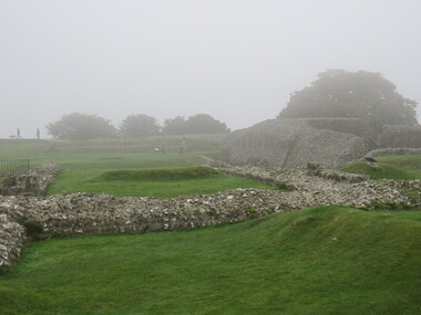
 Ballarat Heritage Services
Photograph - Colour, looking from Stonework towards earth mounds, Old Sarum, England, English Heritage Site, 2016, 01 November 2016
... Ballarat Heritage Services PO Box 2209 Bakery Hill Post Office goldfields William the Conqueror inherited Old Sarum from the last Saxon king of England. It was an ideal site for a royal castle. It was here in 1070 that William paid off his army after a long and bitter campaign ...William the Conqueror inherited Old Sarum from the last Saxon king of England. It was an ideal site for a royal castle. It was here in 1070 that William paid off his army after a long and bitter campaign in northern England. It was here in 1086 that he called together all the major landholders in England so they could swear allegiance to him. It was a crucial moment. The Domesday Book was being written, a threatened Viking invasion had only just been averted and William's eldest son was in armed rebellion. Old Sarum was an important place where this Norman king of England held power. In 1794 the Ordnance Survey set out to check the accuracy of the first mapping of Southern England, which had begun ten years earlier. From a point just below Old Sarum Lieutenant William Mudge laid out a base-line 36,574 feet (11,253 metres) long. From each end of the line the positions of distant places were plotted using a huge theodolite made in 1791 by Jesse Ramsden. The accuracy of the process, which was repeated all over England, depended on Jesse Ramsden's craftsmanship and on William Mudge's surveying skill in setting out this first base-line from Old Sarum. The nearer end of Mudge's line is marked by an inscribed stone beside the modern A345 at Old Sarum. ordnance survey, william mudge, jesse ramsden, william the conqueror, old sarum, saxon, 1086, england -
 Ballarat Heritage Services
Photograph - Colour, Looking from Stonework towards people walking on earth mounds, Old Sarum, England, English Heritage Site, 2016, 01 November 2016
... Ballarat Heritage Services PO Box 2209 Bakery Hill Post Office goldfields William the Conqueror inherited Old Sarum from the last Saxon king of England. It was an ideal site for a royal castle. It was here in 1070 that William paid off his army after a long and bitter campaign ...William the Conqueror inherited Old Sarum from the last Saxon king of England. It was an ideal site for a royal castle. It was here in 1070 that William paid off his army after a long and bitter campaign in northern England. It was here in 1086 that he called together all the major landholders in England so they could swear allegiance to him. It was a crucial moment. The Domesday Book was being written, a threatened Viking invasion had only just been averted and William's eldest son was in armed rebellion. Old Sarum was an important place where this Norman king of England held power. In 1794 the Ordnance Survey set out to check the accuracy of the first mapping of Southern England, which had begun ten years earlier. From a point just below Old Sarum Lieutenant William Mudge laid out a base-line 36,574 feet (11,253 metres) long. From each end of the line the positions of distant places were plotted using a huge theodolite made in 1791 by Jesse Ramsden. The accuracy of the process, which was repeated all over England, depended on Jesse Ramsden's craftsmanship and on William Mudge's surveying skill in setting out this first base-line from Old Sarum. The nearer end of Mudge's line is marked by an inscribed stone beside the modern A345 at Old Sarum. ordnance survey, william mudge, jesse ramsden, william the conqueror, old sarum, saxon, 1086, england -
 Ballarat Heritage Services
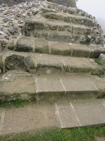
Photograph - Colour, Stairs, Old Sarum, England, English Heritage Site, 2016, 01 November 2016
... Ballarat Heritage Services PO Box 2209 Bakery Hill Post Office goldfields William the Conqueror inherited Old Sarum from the last Saxon king of England. It was an ideal site for a royal castle. It was here in 1070 that William paid off his army after a long and bitter campaign ...William the Conqueror inherited Old Sarum from the last Saxon king of England. It was an ideal site for a royal castle. It was here in 1070 that William paid off his army after a long and bitter campaign in northern England. It was here in 1086 that he called together all the major landholders in England so they could swear allegiance to him. It was a crucial moment. The Domesday Book was being written, a threatened Viking invasion had only just been averted and William's eldest son was in armed rebellion. Old Sarum was an important place where this Norman king of England held power. In 1794 the Ordnance Survey set out to check the accuracy of the first mapping of Southern England, which had begun ten years earlier. From a point just below Old Sarum Lieutenant William Mudge laid out a base-line 36,574 feet (11,253 metres) long. From each end of the line the positions of distant places were plotted using a huge theodolite made in 1791 by Jesse Ramsden. The accuracy of the process, which was repeated all over England, depended on Jesse Ramsden's craftsmanship and on William Mudge's surveying skill in setting out this first base-line from Old Sarum. The nearer end of Mudge's line is marked by an inscribed stone beside the modern A345 at Old Sarum. ordnance survey, william mudge, jesse ramsden, william the conqueror, old sarum, saxon, 1086, england -
 Ballarat Heritage Services
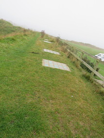
Photograph - Colour, Public toilets hidden in earth mound, Old Sarum, England, English Heritage Site, 2016, 01 November 2016
... Ballarat Heritage Services PO Box 2209 Bakery Hill Post Office goldfields William the Conqueror inherited Old Sarum from the last Saxon king of England. It was an ideal site for a royal castle. It was here in 1070 that William paid off his army after a long and bitter campaign ...William the Conqueror inherited Old Sarum from the last Saxon king of England. It was an ideal site for a royal castle. It was here in 1070 that William paid off his army after a long and bitter campaign in northern England. It was here in 1086 that he called together all the major landholders in England so they could swear allegiance to him. It was a crucial moment. The Domesday Book was being written, a threatened Viking invasion had only just been averted and William's eldest son was in armed rebellion. Old Sarum was an important place where this Norman king of England held power. In 1794 the Ordnance Survey set out to check the accuracy of the first mapping of Southern England, which had begun ten years earlier. From a point just below Old Sarum Lieutenant William Mudge laid out a base-line 36,574 feet (11,253 metres) long. From each end of the line the positions of distant places were plotted using a huge theodolite made in 1791 by Jesse Ramsden. The accuracy of the process, which was repeated all over England, depended on Jesse Ramsden's craftsmanship and on William Mudge's surveying skill in setting out this first base-line from Old Sarum. The nearer end of Mudge's line is marked by an inscribed stone beside the modern A345 at Old Sarum. ordnance survey, william mudge, jesse ramsden, william the conqueror, old sarum, saxon, 1086, england -
 Ballarat Heritage Services
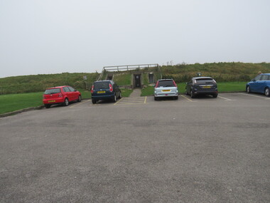
Photograph - Colour, Entrance to Public toilets hidden in earth mound, Old Sarum, England, English Heritage Site, 2016, 01 November 2016
... Ballarat Heritage Services PO Box 2209 Bakery Hill Post Office goldfields William the Conqueror inherited Old Sarum from the last Saxon king of England. It was an ideal site for a royal castle. It was here in 1070 that William paid off his army after a long and bitter campaign ...William the Conqueror inherited Old Sarum from the last Saxon king of England. It was an ideal site for a royal castle. It was here in 1070 that William paid off his army after a long and bitter campaign in northern England. It was here in 1086 that he called together all the major landholders in England so they could swear allegiance to him. It was a crucial moment. The Domesday Book was being written, a threatened Viking invasion had only just been averted and William's eldest son was in armed rebellion. Old Sarum was an important place where this Norman king of England held power. In 1794 the Ordnance Survey set out to check the accuracy of the first mapping of Southern England, which had begun ten years earlier. From a point just below Old Sarum Lieutenant William Mudge laid out a base-line 36,574 feet (11,253 metres) long. From each end of the line the positions of distant places were plotted using a huge theodolite made in 1791 by Jesse Ramsden. The accuracy of the process, which was repeated all over England, depended on Jesse Ramsden's craftsmanship and on William Mudge's surveying skill in setting out this first base-line from Old Sarum. The nearer end of Mudge's line is marked by an inscribed stone beside the modern A345 at Old Sarum. ordnance survey, william mudge, jesse ramsden, william the conqueror, old sarum, saxon, 1086, england