Showing 153 items matching "historic plaque"
-
 Rutherglen Historical Society
Image, 1985
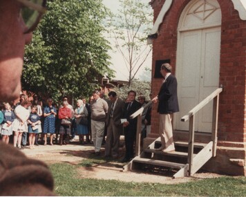
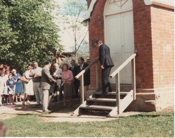
... ...historic plaque...Colour photograph of a group of people near the front steps of Rutherglen Common School No. 522, one man standing on the steps near the historic plaque....The Common School No. 522 is now the Common School Museum of the Rutherglen Historical Society. common school rutherglen common school school buildings historic plaque On back of photo: "Rutherglen | Mayor addressing crowd after unveiling of plaque on the old Common School 1985" Colour photograph of a group of people near the front steps of Rutherglen Common School No. 522, one man standing on the steps near the historic plaque. ...One of a series of photographs taken during the Victoria 150 celebrations. The Common School No. 522 is now the Common School Museum of the Rutherglen Historical Society.Colour photograph of a group of people near the front steps of Rutherglen Common School No. 522, one man standing on the steps near the historic plaque.On back of photo: "Rutherglen | Mayor addressing crowd after unveiling of plaque on the old Common School 1985"common school, rutherglen common school, school buildings, historic plaque -
 St Patrick's Old Collegians Association (SPOCA)
Photograph - History, SPJC Tower Project
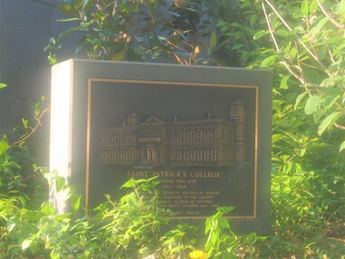
... SPJC Historic Plaque and surroundings adjacent to Tower in 2006...St Patrick's Old Collegians Association (SPOCA) Formerly Cnr of Cathedral Place & Lansdowne Street East Melbourne melbourne SPJC Historic Plaque and surroundings adjacent to Tower in 2006 Photograph History, SPJC Tower Project ... -
 St Patrick's Old Collegians Association (SPOCA)
Photograph - History, SPJC Tower Project
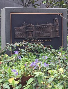
... SPJC Historic Plaque adjacent to Tower - being reclaimed by nature (2015)...St Patrick's Old Collegians Association (SPOCA) Formerly Cnr of Cathedral Place & Lansdowne Street East Melbourne melbourne SPJC Historic Plaque adjacent to Tower - being reclaimed by nature (2015) Photograph History, SPJC Tower Project ... -
 Waverley RSL Sub Branch
Plaque Historic RSL & RAC Badges, Historic RSL & RAC Badges
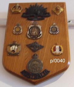
... Plaque Historic RSL & RAC Badges ...Waverley RSL Sub Branch 161 Coleman Parade Glen Waverley melbourne Historic RSL & RAC Badges Wooden Plaque 15cm x 13cm Historic RSL & RAC Badges Plaque Historic RSL & RAC Badges ...Wooden Plaque 15cm x 13cmHistoric RSL & RAC Badges -
 Merbein District Historical Society
Journal - Quarterly, Merbein Historian - Quarterly Journal of MDHS - No 38 (2 copies), Dec.2009
... ... Palms Historic plaque...Merbein District Historical Society 36 Box St Merbein the-murray Christmas Merbein 1929 Curtis - Hilda Christmas Pudding Jenny Hawkes Alison Whiting Centenary Celebrations Pictorial Raylee Schultz Bill Bennett Let the Wedding Bells Ring Rhonda Murray Tony McKenzie Val Golding Palms Historic plaque Centenary Room Cowanna Bend Picnic 1912 - 1916 Fred Curtis Betty Henderson Jill Thomson Bernadette Wells Kevin Forbes Vernon (Cr) Knight Laurie Henderson Alf Henderson Annie Henderson Walter Humphrey Henry Curtis Maria Treadwell Vincent Treadwell Myrtle & Thomas McMillan Maggie & Jim McMillan Florence Treadwell Hilda Curtis Eva Bush Nell Treadwell William & Muriel Lindenberg Leigh Treadwell John Arnold Merbein Historian - Quarterly Journal of MDHS - No 38 (2 copies) Journal Quarterly ...christmas merbein 1929, curtis - hilda christmas pudding, jenny hawkes, alison whiting, centenary celebrations pictorial, raylee schultz, bill bennett, let the wedding bells ring, rhonda murray, tony mckenzie, val golding, palms historic plaque, centenary room, cowanna bend picnic 1912 - 1916, fred curtis, betty henderson, jill thomson, bernadette wells, kevin forbes, vernon (cr) knight, laurie henderson, alf henderson, annie henderson, walter humphrey, henry curtis, maria treadwell, vincent treadwell, myrtle & thomas mcmillan, maggie & jim mcmillan, florence treadwell, hilda curtis, eva bush, nell treadwell, william & muriel lindenberg, leigh treadwell, john arnold -
 Rutherglen Historical Society
Image, 1985
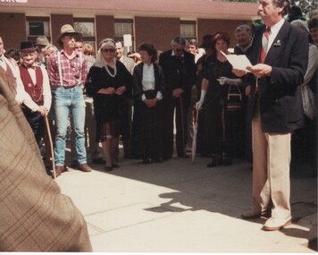
... ...historic plaque...The old Bank of Victoria is now (2017) the NAB. nab bank of victoria historic plaque On back of photo: "Rutherglen | The Mayor addressing crowd after the unveiling of plaque on old Bank of Vic. 1985" Colour photograph of a man giving a speech to a group of people, some of whom are wearing period costume. ...One of a series of photographs taken during the Victoria 150 celebrations. The old Bank of Victoria is now (2017) the NAB.Colour photograph of a man giving a speech to a group of people, some of whom are wearing period costume.On back of photo: "Rutherglen | The Mayor addressing crowd after the unveiling of plaque on old Bank of Vic. 1985"nab, bank of victoria, historic plaque -
 Rutherglen Historical Society
Image, 1985
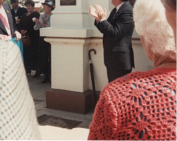
... ...historic plaque...The old Bank of Victoria is now (2017) the NAB. nab bank of victoria historic plaque On back of photo: "Rutherglen | Unveiling of plaque on the old Bank of Victoria. ...One of a series of photographs taken during the Victoria 150 celebrations. The old Bank of Victoria is now (2017) the NAB.Colour photograph of a people applauding after the unveiling of a plaque. Some of the people are wearing period costume.On back of photo: "Rutherglen | Unveiling of plaque on the old Bank of Victoria. Victoria's 150th celebrations"nab, bank of victoria, historic plaque -
 Rutherglen Historical Society
Image, 1985
... Colour photograph of a group of people near the front steps of Rutherglen Common School No. 522, during the unveiling of the historic plaque....The Common School No. 522 is now the Common School Museum of the Rutherglen Historical Society. common school rutherglen common school school buildings On back of photo: "Rutherglen | Unveiling of plaque at the old 'Common School' 1985" Colour photograph of a group of people near the front steps of Rutherglen Common School No. 522, during the unveiling of the historic plaque. Image ...One of a series of photographs taken during the Victoria 150 celebrations. The Common School No. 522 is now the Common School Museum of the Rutherglen Historical Society.Colour photograph of a group of people near the front steps of Rutherglen Common School No. 522, during the unveiling of the historic plaque.On back of photo: "Rutherglen | Unveiling of plaque at the old 'Common School' 1985"common school, rutherglen common school, school buildings -
 Greensborough Historical Society
Flyer - Leaflet, Greensborough Networking Breakfast 2020, 25/03/2020
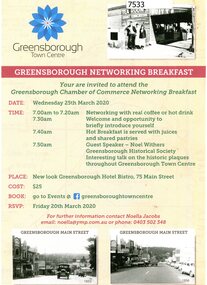
... The Greensborough Chamber of Commerce Networking Breakfast was held at the Greensborough Hotel Bistro on Wednesday 25th March 2020 with guest speaker Noel Withers of GHS speaking about the historic plaques in the town centre....Greensborough Historical Society 34A Glenauburn Road Lower Plenty Lower Plenty melbourne The Greensborough Chamber of Commerce Networking Breakfast was held at the Greensborough Hotel Bistro on Wednesday 25th March 2020 with guest speaker Noel Withers of GHS speaking about the historic plaques in the town centre. greensborough chamber of commerce noel withers main street plaques project Single page, printed in colour on one side. ...The Greensborough Chamber of Commerce Networking Breakfast was held at the Greensborough Hotel Bistro on Wednesday 25th March 2020 with guest speaker Noel Withers of GHS speaking about the historic plaques in the town centre.Single page, printed in colour on one side.greensborough chamber of commerce, noel withers, main street plaques project -
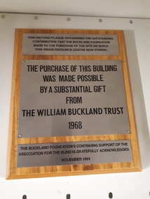 Vision Australia
Image, The William Buckland Trust 1968, 1994
... This historic plaque recognises the outstanding contribution that the Buckland Foundation made to the purchase of the site on which the Vision Resource Centre now stands. ...The support from the Buckland Trust in 1968 was not forgotten however, and this plaque acknowledges the support gained in purchasing the land. association for the blind H & L Hecht Trust William Buckland Trust This historic plaque recognises the outstanding contribution that the Buckland Foundation made to the purchase of the site on which the Vision Resource Centre now stands. ...The William Buckland Trust (now Foundation) provides support for disadvantaged Victorians through support for four key areas. The growing need for space at the Association for the Blind's offices in Kooyong was constraining the amount of people who could benefit from it's programs. With the assistance of the William Buckland and Hecht Trusts, the adjoining blocks of flats fronting Glenferrie Road were acquired and eventually demolished to make way for the Vision Resource Centre. The support from the Buckland Trust in 1968 was not forgotten however, and this plaque acknowledges the support gained in purchasing the land.Digital image of metal plaques attached to a boardThis historic plaque recognises the outstanding contribution that the Buckland Foundation made to the purchase of the site on which the Vision Resource Centre now stands. The purchase of this building was made possible by a substantial gift from the William Buckland Trust 1968. The Buckland Foundation's continuing support of the Association for the Blind is gratefully acknowledged. November 1994.association for the blind, h & l hecht trust, william buckland trust -
 Geoffrey Kaye Museum of Anaesthetic History
Photograph, Morton House
... On the back of the frame is the hand-written message from Dr Bath, information about the house, a reproduction of the brass plaque with historic details, and the framer's label....On the back of the frame is the hand-written message from Dr Bath, information about the house, a reproduction of the brass plaque with historic details, and the framer's label. ...A colour photograph depicting Morton House in Launceston, Tasmania. The photograph is set on a wide blue mounting board in a plain single-strip wooden frame. Affixed to the front bottom right hand corner is the oblong blue label of the National Trust of Australia (Tasmania) with printed heritage details of the house. On the back of the frame is the hand-written message from Dr Bath, information about the house, a reproduction of the brass plaque with historic details, and the framer's label.Handwritten on reverse. "Photo taken v presented by Stewart Bath S. 692" Handwritten on reverse. ""Morton House" / 190 Charles St / Launceston / Was St Johns Hospital 1844–1851" Reproduction of brass plaque on reverse. "ERECTED BY THE HISTORICAL SOCIETY OF TASMANIA TO COMMEMORATE THE FIRST USE IN AUSTRALIA OF ANAESTHETICS BY DR. W. R. PUGH IN ST. JOHN'S HOSPITAL ON THIS SITE 7TH JUNE, 1847. / UNVEILED BY THE MINISTER FOR HEALTH (HON. A. J. WHITE M. H. A), 7TH JULY 1947." Framer's label on reverse. "FRAMED BY WHITELAWS GALLERIES / The Picture Framing Specialists / 49A BRISBNE STREET LAUNCESTON 7250"photograph, morton house, historical building, historical house, house -
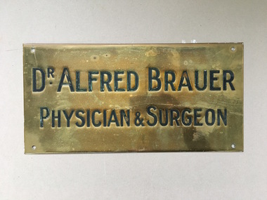 Warrnambool and District Historical Society Inc.
Brass Plate, Dr Alfred Brauer, Circa 1930
... It therefore has strong historic and social significance. warrnambool dr a e brauer alfred brauer warrnambool doctors warrnambool doctors 1940-50's ambleside warrnambool Dr. Alfred Brauer physician & Surgeon Rectangular brass plaque ...This plaque is the name plate of one of Warrnambool's longest serving doctors. Alfred Ernest Brauer came to Warrnambool after graduating from the University of Melbourne in 1927. He initially took up the position as resident medical officer at the Warrnambool Base Hospital before entering private practice. he was appointed honorary medical officer at the hospital and was a life member of the Hospital board , serving as its president from 1952-54.he was a founding member of the South Western Victoria Ambulance service.as vice president, a position he held until his death in 1972.He had wide sporting and community interests including cricket, football, and horseracing. He was a founding member of the Warrnambool Lutheran church and was closely associated with Warrnambool High School and Warrnambool Technical School. he died in September 1972 and was survived by his wife and three daughters. His practice was situated in Koroit StWarrnambool, firstly at Ambleside where he also lived, then later on the other side of the street , in practice with a number of other doctors. A link to one of Warrnambool's longest serving doctors who contributed to the city in a wide range of roles. It therefore has strong historic and social significance.Rectangular brass plaque stamped and infilled with black. A screw hole in each of the four corners.Dr. Alfred Brauer physician & Surgeonwarrnambool, dr a e brauer, alfred brauer, warrnambool doctors, warrnambool doctors 1940-50's, ambleside warrnambool -
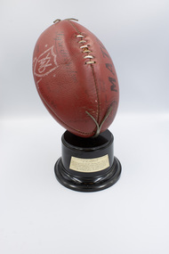 Emerald Museum & Nobelius Heritage Park
Award - Football Trophy, Nutting & Young, 1977
... historic Victorian sports equipment makers, Nutting & Young, who ceased operations in 1977. This is an example of a creative sporting trophy which recognised an Emerald Football Club player's outstanding achievement. Local football and other sporting teams are often integral to the economic and social development of an area. Emerald Football Club On metal plaque ...The Emerald Football club history dates from 1904, and like many local clubs and organisations, has always played an important role in the community. This trophy was awarded to Geoff "Digger" Dolan of the Emerald Football Club for scoring 15 goals in a single match against the Woori Yallock Club on the 9th of July 1977. The match broke the club record at the time, resulting in 120 goals being scored in 12 matches from the 16th of April to 9th of July 1977. The trophy consisting of an Australian Rules football mounted on a stand was probably the same football that was used in the match. The football was manufactured by historic Victorian sports equipment makers, Nutting & Young, who ceased operations in 1977.This is an example of a creative sporting trophy which recognised an Emerald Football Club player's outstanding achievement. Local football and other sporting teams are often integral to the economic and social development of an area.A trophy consisting of an actual Australian Rules football secured onto a hard plastic stand with a metal clasp. A metal plaque on the stand is inscribed with the award details. The football is mounted in an upward and forward position as though ready to be kicked.On metal plaque inscribed: 'PRESENTED TO G. 'DIGGER' DOLAN / CLUB RECORD OF 15 GOALS IN A MATCH / AGAINST WOORI YALLOCK JULY 1977 / 102 GOALS IN 12 MATCHES / 16 APRIL 1977 - 5 JULY 1977' On the football, printed: 'Football made by Nutting & Young, Vic/ NFL APPROVED' Also on the football handwritten signatures of (presumably) other team membersemerald football club -
Federation University Historical Collection
Document, Zelda Martin, Central Victorian Goldmining towns - Boom Towns or Ghost Towns?, c1996
... Black display book titled Local Towns 1 : Alma: *Brief history *Directory *Maps Amphitheatre / Mountain Hut: *Brief History Post Office Directory Ararat: *Brief History *Post Office Directory 1869 - Alphabetical Listing by Occupation *Ararat - Prominent Citizens of 1858 *Langi-Morgala Museum Avoca: *Brief History *Excerpts from 'Avoca The Early Years', Margery and Betty Beavis; pg1 - Beginnings; pg11 - The Midas Touch; pg25 - Local Gold Escorts; pg27 - A Town is Born; pg51- The Administration of Justice; pg53 - The Ways of the Law; pg61 - News of the Day; pg65 - A Time to Play; pg72 - Land Ownership *Post Office Directory (Bailliere's) 1869 *Tourism Map and Information of area *Historic Avoca - A 5.5km Tour *Avoca & the Pyrenees Region - information pamphlet Ballarat: *Early History of Ballarat - Ballarat Historical Society, Publication No.1: origin of the name; Ballaarat - the Beginning; Fabulous Yields from the Ballaarat Goldfield; *Streetscape Lydiard Street. *Hand drawn map showing Leigh River, Old Portland Bay Road, plaque...Black display book titled Local Towns 1 : Alma: *Brief history *Directory *Maps Amphitheatre / Mountain Hut: *Brief History Post Office Directory Ararat: *Brief History *Post Office Directory 1869 - Alphabetical Listing by Occupation *Ararat - Prominent Citizens of 1858 *Langi-Morgala Museum Avoca: *Brief History *Excerpts from 'Avoca The Early Years', Margery and Betty Beavis; pg1 - Beginnings; pg11 - The Midas Touch; pg25 - Local Gold Escorts; pg27 - A Town is Born; pg51- The Administration of Justice; pg53 - The Ways of the Law; pg61 - News of the Day; pg65 - A Time to Play; pg72 - Land Ownership *Post Office Directory (Bailliere's) 1869 *Tourism Map and Information of area *Historic Avoca - A 5.5km Tour *Avoca & the Pyrenees Region - information pamphlet Ballarat: *Early History of Ballarat - Ballarat Historical Society, Publication No.1: origin of the name; Ballaarat - the Beginning; Fabulous Yields from the Ballaarat Goldfield; *Streetscape Lydiard Street. *Hand drawn map showing Leigh River, Old Portland Bay Road, plaque ...Zelda Martin was a PhD candidate at the University of Melbourne.[.1] 4th item in light blue display book titled Research Approach/Overview of Chapters/Confirmation of Canditure/Chapters1,2,3&4 of proposed thesis. *Twenty-seven page article on Victorian goldfields towns titled: Central Victorian Goldmining Towns - Boom Towns or Ghost Towns. The article was written during the author's PhD study. It outlines the context methodology, and resources and the chapters of the proposed thesis: (1) Central Victorian Goldmining Towns - The Context (2) Contemporary Views of the Factors Necessary for Town Growth (3) Outward Manifestations of Town Growth (4) The Trappings of Government (5-9) The Main Towns and Their Hinterland. [.2] 5th item in Light Blue display book as above item. *Chapter 1 of proposed thesis titled 'Pick, Shovel and Tin Dish Mining.' Covers in Section A: Central Victoria - Pre 1851: Aborigines in Central Victoria, Squatters, and Government. Section B: The years 1851-1854: The Early Gold Rushes, Government Reaction, Township Surveys, Legislation, Town Development, Local Government and Early Settlement. [.3] 6th item in Light Blue display book as above item. *2A of proposed thesis titled 'Contemporary Views of the Factors Necessary for Town Growth'. Similar information to Chapter 1 plus extra re towns and maps. Sections: Introduction, Context of Place - Geographical Towns Listed, The Context of Time - Pre1851 Aborigines, Governance of Port Phillip, The Squatters, The Villages of Central Victorian Highlands, Conclusion, Condensed Version of Chapter2B. [.4] 7th item in Light Blue display book as above item. *Chapter2B of proposed thesis. Sections: Area of Research, Schools, Banks, Newspapers, Progress Association, Town Development - Sandhurst (Bendigo), Ballarat, Castlemaine,, Maryborough, Ararat and Stawell. [.5] 8th item in Light Blue display book as above item. *Chapter 3 of proposed thesis titled 'Outward Manifestations of Town Growth'. Sections: Introduction, Contemporary Writing, Educationalists, The Bankers, The Townsfolk, Current Theory, General Theories of Urban Development, and Conclusion. [.6] 9th item in Light Blue display book as above item. *Chapter 4 of proposed thesis titled 'Trappings of Government' Sections: Introduction, Early Government Attitudes to Mining and Town Development, Law and Order, Township Surveys, Legislation, Local Government, Transport and Communication, The People and Lobbyists. [.7] 10th item in Light Blue display book as above item. *'The Rise and Fall of Central Victorian Goldmining Towns'. Includes a map showing main Goldfields, a table showing towns and villages at two points in time - 1857 and 1871; a Bibliography of Primary and Secondary Sources. [.8] Resource No1. Black display book titled Local Towns 1 : Alma: *Brief history *Directory *Maps Amphitheatre / Mountain Hut: *Brief History Post Office Directory Ararat: *Brief History *Post Office Directory 1869 - Alphabetical Listing by Occupation *Ararat - Prominent Citizens of 1858 *Langi-Morgala Museum Avoca: *Brief History *Excerpts from 'Avoca The Early Years', Margery and Betty Beavis; pg1 - Beginnings; pg11 - The Midas Touch; pg25 - Local Gold Escorts; pg27 - A Town is Born; pg51- The Administration of Justice; pg53 - The Ways of the Law; pg61 - News of the Day; pg65 - A Time to Play; pg72 - Land Ownership *Post Office Directory (Bailliere's) 1869 *Tourism Map and Information of area *Historic Avoca - A 5.5km Tour *Avoca & the Pyrenees Region - information pamphlet Ballarat: *Early History of Ballarat - Ballarat Historical Society, Publication No.1: origin of the name; Ballaarat - the Beginning; Fabulous Yields from the Ballaarat Goldfield; *Streetscape Lydiard Street. *Hand drawn map showing Leigh River, Old Portland Bay Road, plaque on road to Colac; etc. *Newspaper article re 'The Theatre Royal' ( which stood in the vicinity of the current Owen Williams store) - 'The News'15/04/1998 *Article - 'Ballarat's Mechanics' Institute Lives On' Ballarat Courier, 14/09/1985 *Article - Standing the Test of Time' The News 17/11/1993 re The Mechanics Institute & picture of the Reading Room *'Ballarat a Study of a City, Phyllis Reichl, pub. Nelson, 1968; no.3 place, time and people field studies series *Investigator Vol.33 No.2, 1998 Geelong Historical Society. Article on pg75 describes Ballarat in 1861 *Folded poster - 'Ballarat 100' a history of telegraph communication, pub. Telecom. Beaufort (Fiery Creek): *Brief history *Post Office Directory [.9] Resource No.2 Black Folder Titled Towns cont.No2 Bendigo (Sandhurst): *'Family & Local History at the Bendigo Library - 1851-2001 150 years of gold'. *Bendigo Government Camp in 1853 illustration; key to sketch and names of Government officers stationed there *Excerpts from 'Bendigo and Vicinity' Adolph Haman *The Bendigo Goldfield Registry - pgs 1-7 Introduction *Excerpt: 'Breaking the Grip' *Excerpt: The Most Go-Ahead Place *Excerpts from 'History of Bendigo' - anti license agitation; laying out of town; proposed railway; gold calls and dividends; the Sandhurst Municipality; journalism *Bibliography Blackwood: *Excerpts from 'Aspects of Early Blackwood - The Goldfield, the Landmarks, the Pioneers' Alan J Buckingham and Margaret F Hitchcock, JG Publishing,1980 Buninyong: *A Brief History *Investigator Vol1 No.2 Feb 1966 Geelong Historical Society. Pg3 - Article re gold escort route - Mt Alexander to Adelaide - (see a simple monument on the Western Highway a few miles out of Horsham. Pg 15 - Ballarat Excursion - re the finding of gold. *Three articles published by Buninyong and District Historical Society Inc: (Magpie Exploration; Finding Gold In The Green Hills; Magpie Exploration; Burnt Bridge to Cargarie to Mt Mercer) *Copies of newspaper articles/items *Buninyong Street Directory Carisbrook: *In the Beginning There Was Carisbrook *The History of the Carisbrook Racecourse Carngham / Snake Valley: *Brief History *Directory Castlemaine: *Directory 1865-1866 - Alphabetical and Street *Poster - Castlemaine A Contemporary Guide "The Great Centre" 1866 - A Contemporary Guide to the Fascinating Past *Pamphlet - Castlemaine District Community Hospital *Map - Castlemaine, Maldon & Surrounding Districts *Map and Information - The Dry Diggings Track - a 55kl walk among historic goldfields relics ( Castlemaine Fryerstown Vaughan Mt Franklin Hepburn Daylesford) *Postcard - Former Court House *Directory 1867 - Alphabetical, Trade [.10] Resource No.3 Grey folder Titled Towns 3 Creswick to Maryborough Creswick: *Brief History *Booklet - "Creswick Cemetery Walk" *Booklet - The Buried Rivers of Gold Heritage Trail Creswick *Creswick Historical Museum Information Sheet *Chronological History of Creswick *Alphabetical Directory of the Borough of Creswick *Creswick's Creek Directory 1856 *Historic Creswick Walking Tour *A Brief Account of the Schools of Creswick - Past and Present *100 Years of Railway Travel in Creswick *The Berry Deep Leads *The Spence Home at Jackass Gully in the Creswick State Forest ( William Guthrie Spence - Pioneer) *The New Australian Mine and the 1882 Disaster *Creswick District News, Issue 7, July August 1999 *The Creswick Miners Walk - Information and Map *Maps Chewton: *Brief History *Directory Clunes: *Brief History *Clunes Street Directory Daylesford: *Brief History *Notable Bushfires in Daylesford District Over More Than a Century - "Black Thursday" 1851; 1862; 1899; the Disastrous Hepburn Fire of 1906; 1939; 1944; 1969. *Post Office Directory -Daylesford and Hepburn Dunolly / Inkerman: *Brief History *Directory *Pamphlet - Goldfields Historical Museum *Pamphlet - Historic Dunolly - Victoria's Best Kept Secret *Map of Gold Workings at Dunolly Area - showing where the main gold rushes occurred *Brief History - Inglewood *Directory - Inglewood - Name Occupation, Dwelling Kingower: *Brief History *Directory - Name / Ocupation / Dwelling Linton / Happy Valley / Piggoreet: *Brief History *Directory - Lintons McIvor: *"A History of the Shire and the Township of Heathcote" by J.O. Randell Majorca: *Brief History *Official Post Office Directory 1869 - Name / Occupation/ Address Maldon (Tarrangower): *Brief History Part 1 *Brief History Part 2 *Post Office Directory *List - Alphabetical Order by Names plus Business and Trade (Tarrangower Times Oct/1858) *List - Alphabetical Order by Trade plus Name and Business *Directory - Name / Occupation / Dwelling Maryborough: *Worsley Cottage - built by Arthur Worsley, a contractor in stonework in 1894 [.11] Resource No. 4 Blue Display Book titled Towns 4 Moliagul to Stawell Moliagul: *Brief History *Moligul Legislative Assembly (Voting?) List - Names and Occupations *Moliagul Victorian Post Office Directory 1868 - Name / Ocupation / Address / Comments *"The Welcome Stranger" gold nugget *The Sunday School *The Welcome Stranger Discovery Walk - information and map Moonambel (Mountain Creek) Redbank *Brief History *List of names extracted from advertisments of the Pioneer and Mountain Creek Advertiser 16/02/1861. *Bailliere's Directory 1869 - Alphabetical List of Name / Occupation / Place St Arnaud: *Brief History Sebastapol: *Brief History *Directory 1869 - Alphabetical by Name; plus occupation and address. Browns and Scarsdale: *Brief History *Browns Street Directory - Name and Occupation Smythesdale: *Brief Description *Smythesdale Street Directory -Name and Occupation Stawell (Pleasant Creek) *Brief History *Victorian Official Post Office Directory - Name /Occupation / Dwelling *Chronology - 1841-1920 *Production of gold statistics - 1879 - 1900 *Big Hill *Extracts from "The Golden Years of Stawell". Chapt 1 - Stawell's Coming Out. Capt. 2 - The Gold Rush. Caapt.3 - Cradle of Democracy. Chapt.4 - The Reefs Becomes Stawell. Chapt. 5 - Rushing In. Chapt.6 - The Pioneers. Chapt 7 - The Decade of Optimism. [.12] Resource No. 5: Blue Display Book titled 'Towns Steiglitz to the The Golden Triangle. Steiglitz: Brief History Victorian Post Office Directory 1869 *Map of Steiglitz *List of maps relevant to Steiglitz history *Information 6 tables of data from "Reports of Mining Surveyors Talbot (Back Creek) Brief History Taradale: Post office Directory 1869 - Name/Occupation/Street. Also list in alphabetical order by Occupation Taradale *Chronological Reference to Taradale Mines *Water - The Coliban System of Waterworks *Joseph Brady *The Syphon Tarnagulla (Sandy Creek) *Brief History *Tarnagulla Businessmen Cameos to give depth to advertisments in 'The Tarnagulla Courier' various issues 1864-1871 *Directory - Name/Occupation /Address *List - Name/Business/Trade Wedderburn (Koorong) *Brief History *List - Name/Occupation The Golden Triangle: *The Early Rushes - Wedderburn / Moliagul / Sandy Creek - Tarnagulla / Jones Creek - Waanyarra / Kingower / Dunolly - Goldsborough / Inglweood *Census of 1857 - Population / Occupations *1858-1871 - A Time of Consolidation- Wedderburn / Moliagul / Sandy Creek- Tarnagulla / Arnold *Census 1871 - Population *Information gleaned from the census data - Demographics / Population / Occupations / marital / Birthplace / Religion / Literacy/ Occupation and Housing Cameos *Graphs - Birthplace of settlers /Male-Female Ratio / Married males / Children under 15 as Percentage of Population / Religion *Census 1857 - Statistical data *Maps *Bibliography [.13] Resource No. 6 - Black Display Book Information and Research in Central Victoria including: *Banking - Research from ANZ Bank Archives *Institutions - also includes articles listed from the Ballarat Times Newspaper *Australian mining History Association - A.M.H.A. Bibliography *Australia's Mining History * Bibliography - Land Surveys Victoria - *1853 Administration (Statistics and Other) includes: schools / ministers of religion / police / military / local administration / licences for sale of spirits / distances between various Victorian gold fields. * Victoria Government Gazette (Copy) - N0. 116, 12/12/1854 includes: Gold Felds Commission of Enquiry & No. 85, 15/09/1854 - Addresses presented to the Lieutenant Governor (Sir Charles Hotham) during his tour through the Gold Fields of Victoria,1854. Addresses on behalf of : the people of Bendigo; Members of the Church of England, Bendigo; Members of the Wesleyan Church on the Bendigo Gold Fields; Bendigo Gold District General Hospital; the Bendigo Prospecting Association; Committee of the Bendigo Local Exhibition; Bendigo District Medical Association; Coloured Americans Resident at Bendigo; German Inhabitants of Bendigo; Landowners, Inhabitants, and Miners of Castlemaine; Inhabitants of Forest Creek; Inhabitants of Heathcote and Gold Miners of McIvor; Residents and landholders of the District of Bacchus Marsh; Inhabitants of Kilmore and Vicinity. *Gold Fields Correspondence 1853: letter from Lieutenant Colonel Valiant, (Officer commanding the Troops in Victoria) to the Lieutenant Governor re threatened disturbance at Sandhurst (Bendigo) regarding the Gold License Fee. * Extracts from a book "Victoria" re Gold Fields Commission of Enquiry involving mainly Ballarat and Castlemaine and a chapter titled 'A Tour to the Victorian Gold-Fields' *Lists of central Victorian newspapers - listed by date published 1851to 1874; by first date available to State Library. *A list of cities and towns showing County, population in 1861 &1871, and municipal status. [.14] Resource no.7. Black display book. *Reference: Papers presented to Parliament Victoria - 1859-1860 4 volumes - relevant sections copied. Contains information on Branches of Government. General / Finance / Gold / Gazette / Commission and Warrant / Statistic. *Gold Fields Act. In accordance with the Act the gold fields are divided into six districts - Ballaarat, Castlemaine , Sandhurst, Avoca, Ararat, and Beechworth.. Official staff in each gold district consists of a Resident Warden, Wardens, Wardens' Clerks, Bailiffs, Chinese Protectors, Chinese Interpreters, and Mining Surveyors. *Gold Receiver *Gaols *Police magistrates and Clerks of Petty Sessions, etc. *Field Branch *Immigration and Emigration Overland - Chinese - 1859 *Population on the Goldfields *The Geological Survey - The Government Geologist is assisited by staff from four branches - the office Branch; the Publishing Branch; the Field Branch and the Museum Branch. *Commission to Enquire Into Sludge dated 10/02/1859 (Some sections copied) - Report to the Honorable Chief Commissioner of Public Works, Melbourne re the mode of carrying the sludge from the puddling mills in Sandhurst without interfering with the drainage of the town and the roads in the neighbourhood. [.15] Resource No.8: Camel display book titled Resource No. 8. Aborigines *Lists of book titles - +"Readings in Victorian prehistory" +"The Aborigines of Port Phillip" +Aboriginal languages and clans" +"A History of the Port Phillip District" +"Langi Ghiran 1: Aboriginal Rock...." +"Koorie History: sources for aboriginal studies in the State Library of Victoria", ed. Tom Griffiths, Melb. Friends of the State Library, 1989 +"The Public Lands of Australia Felix"; settlement and land appraisal in Victoria1834-91 with special reference to the Western Plains", J.M.Powell, Melb. Oxford University Press 1970 +*Bibliography of the Victorian Aborigines' from the earliest manuscripts to 31st December 1970, Massoa, Aldo, Melb. Hawthorn Press, 1971 +"Aborigines in Colonial Victoria, 1836-1886", M.F. Christie, Sydney University Press, 1979 +"Urban and Industrial Australia: readings in Human Geography" ed J.M. Powell, Melb. Sorrett Pub. 1974 *Extracts: -Processes of Pioneer Settlement - The Squatting Occupation of Victoria, 1834-60. J.M. Powell -Areal Variations in the Class Structure of the Central-Place Hierarchy. P. Scott - Volume1 and Volume 2: Notes Relating to the Habits of the Natives of Other Parts of Australia and Tasmania. Compiled from various sources for the Government of Victoria by R Brough Smyth. John Curry, O'Neil, Melb. 1st pub. Melb. 1876. p31-45 - Numbers and Distribution of the Aborigines in Victoria -Victorian Aborigines 1835-1901 - A Resource Guide to the Holdings of the Public Record Office, Victoria; published by the Government Information Centre 1984. *History of the Aboriginal Artefacts Displayed in the Daylesford Museum. F. G. Powell (4 page pamphlet) *Letter to Zelda Martin from Peter Lovett, Cultural Officer, Ballarat & District Aboriginal Co- Operative, 05/02/1997 *Map: Ian Clarke Victorian Tribunal Boundary Map - Clans of Central Victoria. *Victorian Rock Art and Mythology - Article about Mount Langhi Ghiran and myths of the Tjapwarong people. *Two Aboriginal myths relating to the Grampians - 'The Monster Emu' / 'The Aquisition of Fire', by the Aborigines in the Grampians Areas *Article titled (chapter 8) Ballarat - information re camping sites in the region. Lake Wendouree / Lake Burrumbeet (includes a myth) / Mt Bunninyong / Lal Lal / Pitfield / Mount Elephant / Mount Egerton / Meredith / Lake Goldsmith / Lake Learmonth / Ercildoune *Notes on the Aborigines of the Wider Ballarat Region plus European names=Aboriginal names. John Morris 26/07/1995 *Role of Aborigines in Town Development in Central Victoria. Mentions Native Police Force est. in Port Phillip 1842 and Central Board for Aborigines est. 1860 *The Grave of King Billy. (Frank Wilson) Pamphlet. *Camping Places in Central and Northern Victoria. Article re Lake Burrumbeet site. *Programme for the Unveiling of Memorial Cairn for Edward Stone Parker 1802-1865. Note portrait not accurate. Accurate portrait is available in the book "A Successful Failure A Trilogy The Aborigines and Early Settlers", Edgar Morrison, Graffiti Publications, 2002. * Large envelope addressed to Mr G Netherway containing newspaper cuttings regarding the life of Edward Stone Parker, the unveiling of the Memorial Cairn as mentioned above, articles titled 'Episodes from Our Early Days' (Edgar Morrison, Yandoit)- The Black's School, A School At Last and The Final years. Also a typed page titled 'Historical Background to E.S.Parker's Career. Includes an interesting tale titled 'When the cat lay doggo' re laying power leads for the unveiling ceremony at the memorial site. [.16] green display folder titled 'Research Aids' *List of references to Commissioners' & W'ardens' Reports (formerly held at La Trobe Library Archives, now at Public Records Office [PRO]). Indicates town referred to / date of report / name of camp if different to town. * Archive information re Anglican Records *Movement around the Goldfields - Miners and Storekeepers - usefulness of newspapers in providing information - areas covered - Castlemaine, Maldon, Ararat, Stawell, Tarnagulla, Dunolly. *Port Phillip /Victoria Directories 1839/1867 - Chronological list of Directories included in this series. *"Notes on the History of Local Government in Victoria" A.W. Greig Melb. University Press 1925 - Photo-copied extract p5-p40. (Source - Deakin University Library) - Introduction by W.Harrison Moore. Section 1 - Development in New South Wales Before Separation. Section 2 - Development in Victoria After Its Separation from New South Wales. Hand written notations: 'roads, markets, and local government 1855 on' ;'opportunity of squatters in parliament' and 'opportunities of matters in parliament p33' * Notes on the Establishment of Surveyor General's Department 1851and Commissioner of Crown Lands and Survey. * Newspaper articles from The Argus, 1849, re the discovery of gold in the Pyrenees region. * Excerpt - a report on schools - A.B.Orlebar, Inspector; re the need for permanent school buildings rather than tents. *Excerpt from - 'Approaches to Urban History', Sean Glynn: The Case for Caution * Except from - 'The Urban Sprinkle', Weston Bate: Country Towns and Australian Regional History *Reference- 'The History of Land Tenure in the Colony of Victoria', John Quick. References the Haines Land Bill, land tenure and Land Leagues. [.17] Light blue envelope folder titled 'Birtchnell's Ballarat, etc. Directory 1862 *Contains various directories for Smythesdale, Buninyong, Clunes, Brown's and Creswick. [.18] Red envelope folder no.2 titled Victorian Gazetteer *Selected pages from 1869 Victorian Gazetteer on A4 paper (with a handwritten note questioning if some pages are from 1868 Victorian Gazetteer as appears to be different sizes - A3 pages.) Information includes locations and descriptions of towns, hotels, banks, communications and populations. (Does not include names, residences and occupations) [.19] Red Envelope folder titled Bailliere's Official Post Office Directory 1868 (or1869 or a mixture of both?) *Preface *Contains a selection of pages of towns highlighted in yellow in the the index *Work on this directory was commenced in 1867. *Information includes: Municipalities - mayors and councilors; lists of towns naming male inhabitants and their occupations. [.20]Yellow manila folder titled Post Grad Seminar Presentation 1996 *Gives some background to Zelda Martin's proposed thesis and why she chose the topic Gold Mining Towns Boom or Bust [.21] A3 display book - No. 1A * A list of 'Relevant Newspapers collected: The Tarrangower Times and Maldon Advertiser (first published 1858) Includes dates 1858-1867. The Mount Alexander Mail. Includes dates 1854-1866 The Tarnagulla Courier. Includes dates from1864-1871 Dunolly and Burnt Creek Express. Includes dates from 1862-1871 * Selection of newspaper pages from The Mount Alexander Mail 1854 to 1856, mostly showing advertisements for businesses and services provided to that community. [.22] A3 display book - No. 1B * Selection of newspaper pages from The Mount Alexander Mail 1857 to 1866, mostly showing advertisements for businesses and services provided to that community. [.23] A3 display book -No. 2 * Selection of newspaper pages from The Tarnagulla Courier 1864 to 1871, mostly showing advertisements for businesses and services provided to that community. [.24] A3 display book - No. 3 *Selection of newspaper pages from The Tarrangower Times (and Maldon and Newstead) Advertiser 1858 to1867, mostly showing advertisements for businesses and services provided to that community. [.25] A3 display book - No.4 * Selection of newspaper pages from The Dunolly and Burnt Creek Express; and The Dunolly and Betbetshire Express 1862 to 1871, mostly showing advertisements for businesses and services provided for that community. [.26] A3 display book - No.5 Includes: * Bryce Ross's Diggings Directory. Includes instructions for using this directory. This directory was used by "all persons having connexion or desiring to communicate with 'working parties, private friends, or Stores at the Diggings." As a directory for each area wwas completed it was published in each month's issue of Bonwick's "Digger's Magazine." Years c1852/1853. This Directory commences first at the head of Forest Creek. Includes a directory for Bendigo and Ballarat. Of interest at the end of the Bendigo and Ballarat directory is a list of the number of storekeepers, butchers, doctors, smiths, eating houses, lemonade sellers and chapels. * The Castlemaine Directory and Book of General Information Comprehending Glass's Model Calendar for the Two Years 1862 and1863. "zelda martin, victorian goldfield towns, bendigo, castlemaine, ballarat, maldon, stawell, ararat, maryborough, creswick, avoca, heathcote, banks, bank of australasia, union bank of australia, government camp, sandhurst, water supply, tarnagulla, talbot, back creek, mountain creek, police court, carisbrook, dunolly, thompson's foundry, charles clacy, anthony trollope, robert cecil, mount alexander, urbanisation, national schools, education, govenrment, industry, railway, transport, settlement, land settlement in central victoria, steiglitz, joseph brady, the new australian mine, berry deep leads, william guthrie spence, creswick state forest, arthur worsley, worsley cottage, the welcome stranger, moliagul, moonambel, redbank, st arnaud, sebastapol, brown's, scarsdale, clunes, chewton, daylesford, bushfires, inkerman, inglewood, kingower, lintons, happy valley, piggoreet, mcivor, majorca, tarrangower, taradale, the coliban system, the syphon, sandy creek, wedderburn, koorong, arnold, jones creek, waanyarra, the golden triangle, census 1857, blackwood, buninyong, durham lead, magpie, carngham, snake valley, alma, amherst, daisy hill, amphitheatre, mountain hut, beaufort, fiery creek, counties, population, gold fields commission of enquiry1854, william westgarth, gold license fee, lieutenant colonel valiant, administration of the victorian gold fields, commission to enquire into sludge 1859, e.s. parker, edward stone parker, edgar morrison, mount franklin protectorate, dja dja wurrung, memorial cairn, franklinford, mt franklin memorial cairn, jajowurrong, dja dja wurung, tjaowarong, wothowurong, assistant protectors, daylesford museum, buluk, rock art - grampians, aboriginal mythology - grampians, aborigines, first nations people, mount franklin, aboriginal artifacts, lake burrumbeet, native police force, central board of aborigines, yandoit, commissioners' reports, wardens' reports, port phillip/victoria directories 1839-1867, local government - victoria 1853/1854, surveyor general's department - 1850's, victorian schools 1850's, a.b.orlebar, haines land bill, william charles haines, wilson gray, land tenure, land leagues, victorian gazetteer, the tarrangower times and maldon advertiser - 1858-1867, the mount alexander mail 1854-1866, the tarnagulla courier 1864, dunolly and burnt creek express 1862-1871, bryce rose's diggings directory, the castlemaine directory 1862-1863 -
Ballarat Clarendon College
Trowel
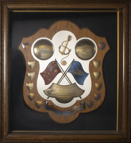
... Accompanying plaque inscribed: 'With this Historic Trowel / on 9th June 1924 / THE FOUNDATION STONE OF THE MEMORIAL HALL / was laid by / BRIG. ...Accompanying plaque inscribed: 'With this Historic Trowel / on 9th June 1924 / THE FOUNDATION STONE OF THE MEMORIAL HALL / was laid by / BRIG. ...The trowel was presented to Revd. William Henderson, founder and first Headmaster of Ballarat College, by H R Caselli, Architect, on the occasion of his laying the Foundation Stone of Ballarat College, 12 September 1874. The building was erected beside St. Andrew's Kirk in Sturt Street, Ballarat. The trowel was donated by Revd. Henderson's son, Charles James Henderson, on 1 May 1920 along with a small silver plaque. In 1924, the trowel was used by Brigadier-General H E 'Pompey' Elliott, CB, CMG, DSO, DCM to lay the Foundation Stone of Memorial Hall, Ballarat College on 9 June 1924 (Memorial Hall opened 8 June 1925). A small silver plaque commemorates this event.Ornate, sterling silver, elongated-heart-shaped trowel with turned wooden handle. The top of the trowel plate is engraved with a detailed scroll and leaf design around edges and an inscription in the middle. The back of trowel plate is plain except for a small manufacturer's stamp. The trowel is accompanied by two small sterling silver inscribed plaques. Engraved inscription: 'Presented to / The Revd Wm Henderson / BALLARAT/ By / H. R. Caselli / Architect / on the occasion of his laying the / FOUNDATION STONE / OF THE / BALLARAT COLLEGE / 12th Sept. 1874.' Manufacturer's stamp on back of trowel plate: 'J. T. Sleep' Accompanying plaque inscribed: 'PRESENTED TO THE / BALLARAT COLLEGE / ON 1ST MAY 1920 BY / C.J.HENDERSON / (THIRD PUPIL IN 1864) / AND SON OF / REV.WILLIAM HENDERSON / FOUNDER OF THE COLLEGE'. Accompanying plaque inscribed: 'With this Historic Trowel / on 9th June 1924 / THE FOUNDATION STONE OF THE MEMORIAL HALL / was laid by / BRIG. GEN. H. E. ELLIOTT. C.B., C.M.C., H.S.O, D.C.M.'memorial, ballarat college, foundation stone, st andrews kirk, reverend william henderson, 1874, architect, school buildings, hall, h e elliott, pompey elliot, 1924, trowel, h r caselli -
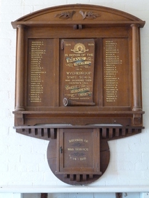 Wycheproof & District Historical Society Inc.
Photo, Mrs Elaine Storey, Wycheproof School Honour Roll 1914 - 1919, 1919
... This plaque recognises the Wycheproof servicemen from State School No1757 who served in the 1914-1919 War. The actual large Honour Roll hangs in the old historic Wycheproof State School building....Wycheproof & District Historical Society Inc. 38 High Street Wycheproof the-murray This plaque recognises the Wycheproof servicemen from State School No1757 who served in the 1914-1919 War. The actual large Honour Roll hangs in the old historic Wycheproof State School building. ...This plaque recognises the Wycheproof servicemen from State School No1757 who served in the 1914-1919 War. The actual large Honour Roll hangs in the old historic Wycheproof State School building.This Honour Roll contributes to and is part of the nation's collection of War Records; it is unique,believed to be the only one of its kind.PHOTO of large Wycheproof School Honour Roll WW1, on wall at the former Wycheproof S.S. No.1757 building - now the Mount Wycheproof Museum. The plaque of solid wood has cylindrical wooden pillars each side of the 55 gold inscribed names - 12 FALLEN servicemen and marked with a +. Raised wooden carved grapes and leaves adorn the top edge. In the centre, on the scroll are dedication words in Honour of the Brave Men From Wycheproof State School. A small wooden cupboard is attached underneath for War Service Records. This photo is in a display Book registered number 02089 at the Court House. Anderson, E. , Anderson, N. , Boyce W. , Bruce R. , Brotherson, H. , + Brotherson, L. , Barker, D. , Beardon, G., Currie N. , Currie, G. , Cutts, R. , Cutts, A. , Chisholm, A. , Cooper, C. , Duckmanton, S. , Dooley, N. , Dooley, J. , Donnelly, T. , Gibb, J.R. +Gregson A. , Hurcules, W. , Hurcules, C. , Hurcules, N. , + Hayes, L. , Hayes, G. , +Hotham, J. , Hindson, E. , Heap, A. , Holloway, V. , Headley, J. , + Kearney, P. , Matheson, H., Matheson, J. , Miles, H. , McDonald, G., McDonald, W., +W., McElphinney, D. , McElphinney, D. , Pratt, A. , + Orrock, P. , + Orrock, A. , + Robinson, S. , Redgen, J. , + Ryan, J.F. , + Slocombe, R. , Stewart, C. , Stewart, R. , Stavely, W. ,+ Sayers, W. , Secombe, W. , Taylor, R. , Tucker, C. , Thomas, R. , Wilson, S. , Ward, P. + Supreme Sacrifice Anderson, E. , Anderson, N. , Boyce W. , Bruce R. , Brotherson, H. , + Brotherson, L. , Barker, D. , Beardon, G., Currie N. , Currie, G. , Cutts, R. , Cutts, A. , Chisholm, A. , Cooper, C. , Duckmanton, S. , Dooley, N. , Dooley, J. , Donnelly, T. , Gibb, J.R. +Gregson A. , Hurcules, W. , Hurcules, C. , Hurcules, N. , + Hayes, L. , Hayes, G. , +Hotham, J. , Hindson, E. , Heap, A. , Holloway, V. , Headley, J. , + Kearney, P. , Matheson, H., Matheson, J. , Miles, H. , McDonald, G., McDonald, W., +W., McElphinney, D. , McElphinney, D. , Pratt, A. , + Orrock, P. , + Orrock, A. , + Robinson, S. , Redgen, J. , + Ryan, J.F. , + Slocombe, R. , Stewart, C. , Stewart, R. , Stavely, W. ,+ Sayers, W. , Secombe, W. , Taylor, R. , Tucker, C. , Thomas, R. , Wilson, S. , Ward, P. + Supreme Sacrifice wycheproof - school, honour roll, world- war-one, wycheproof- servicemen -
Federation University Historical Collection
Book - Book - Scrapbook, Ballarat School of MInes: Scrapbook of Newspaper Cuttings, Book 79. June 1997 to August 1997
... plaque to hanged men...freighter's engineering traineeship...tafe merger creates super-college...smb agrees to merger...wimmera tafe rejects merger...new evidence points to remains' location...peter bailey to compete in youth skills olympics...switzerland...merger official...course on providing a home away from home...roy schrieke retires...descendant against memorial...peter bailey gold medallist...skill olympics in st gallen...excellent results for ballarat region...aquaculture course...historic...The papers concerned are The Courier, Ballarat, The Australian, The Age and other region papers over the period of 7 June 1997 to 5 August 1997. teaching positions advertised pre-employment courses courses available enrolment for smb courses nathan holliday nrma top apprentice scott brady ballarat's gallows mystery solved federal tafe plan worries smb head memorial plaque to hanged men freighter's engineering traineeship tafe merger creates super-college smb agrees to merger wimmera tafe rejects merger new evidence points to remains' location peter bailey to compete in youth skills olympics switzerland merger official course on providing a home away from home roy schrieke retires descendant against memorial peter bailey gold medallist skill olympics in st gallen excellent results for ballarat region aquaculture course historic sites listed henry sutton reverse tafe decision stawell times-news more host families needed david belford award winner city yearning for cultural heart corporate learning gold medal for peter bailey competition on apprentice funding'play revisits our history town and gown debate viticulture traineeship program one tafe division career in food row looms over staff offers jeff kennet cuts new attitude to education victorian primary industries board apprenticeships rural studies department Book with yellow cover, front, spiral bound. ...Collection of newspaper articles related to Ballarat School Of Mines.They cover activities and advertisements for staff. The papers concerned are The Courier, Ballarat, The Australian, The Age and other region papers over the period of 7 June 1997 to 5 August 1997. Book with yellow cover, front, spiral bound. teaching positions advertised, pre-employment courses, courses available, enrolment for smb courses, nathan holliday, nrma top apprentice, scott brady, ballarat's gallows mystery solved, federal tafe plan worries smb head, memorial plaque to hanged men, freighter's engineering traineeship, tafe merger creates super-college, smb agrees to merger, wimmera tafe rejects merger, new evidence points to remains' location, peter bailey to compete in youth skills olympics, switzerland, merger official, course on providing a home away from home, roy schrieke retires, descendant against memorial, peter bailey gold medallist, skill olympics in st gallen, excellent results for ballarat region, aquaculture course, historic sites listed, henry sutton, reverse tafe decision, stawell times-news, more host families needed, david belford award winner, city yearning for cultural heart, corporate learning, gold medal for peter bailey, competition on apprentice funding'play revisits our history, town and gown debate, viticulture traineeship program, one tafe division, career in food, row looms over staff offers, jeff kennet cuts, new attitude to education, victorian primary industries board apprenticeships, rural studies department -
Glen Eira Historical Society
Letter - MONUMENTS AND NATIONAL REGISTER
... historic survey marks located within Glen Eira, as part of a greater project to identify all such survey marks located within Victoria. Also included is a leaflet extrapolating on the project and featuring a form for documenting survey marks, although this contains nothing of relevance specifically to Glen Eira. Glen Eira Caulfield Plaques ...This file contains five items pertaining to plaques, memorials and monuments located in Glen Eira: 1/Three letters (1 page each) pertaining to a statue of Isabelle Webb adorning the Caulfield City Hall. The first letter, typewritten, dated 14/07/80, is addressed from J. Pollet, Honorary Secretary of the Caulfield Historical Society, to Mr. G. Calder, City Manager of Caulfield, and announces that the Society has identified the previously unidentified statue and wishes to provide a plaque for it. The second letter, handwritten, dated 20/09/1980, is addressed from Mr. R. Ballantyne of the Caulfield Historical Society to Calder, and laments that the Caulfield City Council has not responded to the first letter. The third letter, typewritten, dated 24/10/1980, is addressed from G. J. Walker, Deputy Manager-Administrator of the City of Caulfield, to Ballantyne, and notifies the latter of the Council’s acceptance of the Society’s offer to provide a plaque. Also included are the invoice and delivery docket for the plaque. 2/A typewritten letter (1 page), dated 26/06/1985, from Norma Polglase, secretary to mayor Brian Rudzki, inviting Mr. and Mrs. R. Ballantyne to an unveiling ceremony at Hopetoun Gardens. 3/A typewritten letter (1 page), dated 05/10/1986, from John Adams, Convenor of the Memorials Committee of the Royal Historical Society of Victoria, to Miss H. Bullock, thanking the latter for her contributions to the Society’s Memorials Project (which presumably consists of the recording of the location of all memorials located in Victoria), and confirming the acknowledgement of four memorials located in Caulfield. 4/A one page typewritten letter, with handwritten note, dated 07/05/1987, from Chilla Bulbeck, project coordinator of the National Register of the Australian Bicentennial Authority, to Mr. R. Ballantyne, thanking the latter for agreeing to act as a recorder for the Project. Attached are 12 pages extrapolating on the Project and a list (2 copies) of monuments thus far acknowledged, although none of this contains anything of relevance specifically to Glen Eira. 5/A typewritten letter, dated 29/11/1996, from Bob Ross, Senior Surveyor of the Geodetic Survey of the Office of the Surveyor General, to the Caulfield Historical Society, requesting the latter’s assistance in identifying any historic survey marks located within Glen Eira, as part of a greater project to identify all such survey marks located within Victoria. Also included is a leaflet extrapolating on the project and featuring a form for documenting survey marks, although this contains nothing of relevance specifically to Glen Eira.glen eira, caulfield, plaques, monuments and memorials, walker g. j., ballantyne r. mr., caulfield historical society, statues, webb isabelle, webb isabella, calder g, pollet j, city of caulfield, caulfield city council, city hall, hawthorn road, glen eira road, neville street, glenhuntly, thompson p. mr., arrow engraving & foundry co., rudzki brian j. p. cr., ballantyne mrs., cannons, festivals and celebrations, invitations, hopetoun gardens, mayors, glenhuntly road, glen huntly road, caulfield city hall, polglase norma, adams john, bullock h. miss, royal historical society of victoria, memorials committee, memorials project, ‘kadimah’, caulfield grammar school, rosstown railway, bambra park, elsternwick, begonia street, gardenvale, bulbeck chilla, australian bicentennial authority, national register of unusual monuments project, jowett memorial drinking fountain, ross bob, office of surveyor general, geodetic survey office of surveyor general -
Glen Eira Historical Society
Document - Memorials in Glen Eira
... Historical Markers Caulfield City Caulfield Grammar School Elsternwick Regent Street Caulfield Racing Museum Rosstown Railway Marker Caulfield Bambra Road Curraweena Road Marara Road City of Caulfield Mayors Councillors Caulfield Historical Society Rosstown Railway Caulfield Grammar School Pavement Marker Monument to Racehorse ‘Jackstaff’ Ross Murray Browne Thomas Alexander Thomas Alexander Browne Grave Brighton Cemetery Rolf Boldrewood North Road Caulfield South Browne Margaret Maria Grave of Sir John and Lady Monash Monash John Sir Monash Hannah Victoria Lady Frederick Jowett Memorial Drinking Fountain Caulfield Town Hall Hawthorn Road Glen Eira Road Jowett Frederick Borough of Caulfield Adam Lindsay Gordon Grave Gordon Adam Lindsay Gordon Annie Lindsay Jewish Victims of World War 2 Memorial Kadimah Jewish Cultural Centre and Library Selwyn Street Burston Seddon Hopetoun Gardens Cannon Glenhuntly Road Glen Huntly Road Schools Historic Sites Plaques Footpaths Horseracing Horses Jackstaff Monuments and Memorials Railways Authors Cemeteries Graves Gravestones Jewish Community Town Clerks Shire Secretaries Town Hall Drinking Taps Poetry Children Libraries World War 1939 – 1945 Hopetoun Cannons Festivals and Celebrations Document Memorials in Glen Eira ...This file contains one item: 1/A printout from the Victorian Memorials Database, undated and researcher unknown, containing records of 9 memorials in the Caulfield City municipality. These memorials are: - Caulfield Grammar School Site Pavement Marker, Elsternwick - Monument to racehorse ‘Jackstaff’ in Caulfield Racing Museum. - Rosstown Railway Marker, Bambra Road, Caulfield. - Thomas Alexander Browne Grave, Brighton Cemetery. - Grave of Sir John and Lady Monash, Brighton Cemetery. - Frederick Jowett Memorial Drinking Fountain, Caulfield Town Hall - Adam Lindsay Gordon Grave, Brighton Cemetery. - Jewish victims of World War 2 Memorial, Kadimah Centre, Elsternwick. - Hopetown Gardens Cannon, Elsternwick.historical markers, caulfield city, caulfield grammar school, elsternwick, regent street, caulfield racing museum, rosstown railway marker, caulfield, bambra road, curraweena road, marara road, city of caulfield, mayors, councillors, caulfield historical society, rosstown railway, caulfield grammar school pavement marker, monument to racehorse ‘jackstaff’, ross murray, browne thomas alexander, thomas alexander browne grave, brighton cemetery, rolf boldrewood, north road, caulfield south, browne margaret maria, grave of sir john and lady monash, monash john sir, monash hannah victoria lady, frederick jowett memorial drinking fountain, caulfield town hall, hawthorn road, glen eira road, jowett frederick, borough of caulfield, adam lindsay gordon grave, gordon adam lindsay, gordon annie lindsay, jewish victims of world war 2 memorial, kadimah jewish cultural centre and library, selwyn street, burston seddon, hopetoun gardens cannon, glenhuntly road, glen huntly road, schools, historic sites, plaques, footpaths, horseracing, horses, jackstaff, monuments and memorials, railways, authors, cemeteries, graves, gravestones, jewish community, town clerks, shire secretaries, town hall, drinking taps, poetry, children, libraries, world war 1939 – 1945, hopetoun, cannons, festivals and celebrations -
Bendigo Historical Society Inc.
Sculpture - VAHLAND BUST
... plaque with suitable wording giving origin, history and date of acquisition is prepared. When this is ready, we shall advise you further. This piece of art work by the celebrated Otto Waschatz is of very great historic interest and we are extremely happy to have it in our care' R.A. ...plaque with suitable wording giving origin, history and date of acquisition is prepared. When this is ready, we shall advise you further. This piece of art work by the celebrated Otto Waschatz is of very great historic interest and we are extremely happy to have it in our care' R.A. ...Bust of William Charles Vahland, architect (1828 - 1915) Donated to the BHS by B. Melrose, Masonic Hall, Bendigo. Letter from BHS to B. Melrose ' We would like to thank your committee through you for their generous offer - that the W.C. Vahland plaster bust remain with this Society for permanent display at Dudley House. We shall see to it that a plaque with suitable wording giving origin, history and date of acquisition is prepared. When this is ready, we shall advise you further. This piece of art work by the celebrated Otto Waschatz is of very great historic interest and we are extremely happy to have it in our care' R.A. Anderson, President, RHSV Bendigo. dated 15 December 1977. Bust is on permanent loan to Masonic Hall, McIvor Road, Bendigo.person, bendigo, william charles vahland -
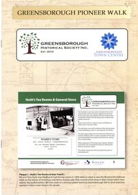 Greensborough Historical Society
Booklet, Greensborough Historical Society Inc, Greensborough Pioneer Walk, 2021
... A guide to the historic photographs which have been mounted on 12 plaques in Greensborough Town Centre. ...Greensborough Historical Society 34A Glenauburn Road Lower Plenty Lower Plenty melbourne A guide to the historic photographs which have been mounted on 12 plaques in Greensborough Town Centre. greensborough pioneer walks greensborough historical society 8 p., photographs, captions and map Greensborough Pioneer Walk Booklet Booklet Greensborough Historical Society Inc. ...A guide to the historic photographs which have been mounted on 12 plaques in Greensborough Town Centre. 8 p., photographs, captions and mapgreensborough, pioneer walks, greensborough historical society -
 Halls Gap & Grampians Historical Society
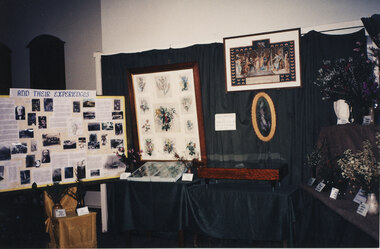
Photograph - Coloured, C 1995
... Historic Section of the 1995 Wildflower Show held in the Halls Gap Hall in 1995. The framed wildflower paintings are by Henrietta D'Alton. Beneath the frame in its current (2010) location in the Halls Gap Hall is a plaque which reads "Henrietta D'Alton (1836-1922). ...Historic Section of the 1995 Wildflower Show held in the Halls Gap Hall in 1995. The framed wildflower paintings are by Henrietta D'Alton. Beneath the frame in its current (2010) location in the Halls Gap Hall is a plaque which reads "Henrietta D'Alton (1836-1922). ...A display in the Historic Section of the 1995 Wildflower Show held in the Halls Gap Hall in 1995. The framed wildflower paintings are by Henrietta D'Alton. Beneath the frame in its current (2010) location in the Halls Gap Hall is a plaque which reads "Henrietta D'Alton (1836-1922). This collection of wildflower water-colours won an award at the Colonial & Indian Exhibition of 1886 in London".The photo shows a display of an historical theme set up in front of a dark fabric draped from a frame and over tables. A framed painting (consisting of twelve individual paintings) can be seen in the centre together with a certificate to its right.events, wildflower show -
 Mission to Seafarers Victoria
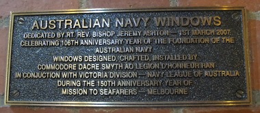
Plaque - Memorial Plaque, Australian Navy, 2007
... historic vessel Dreadnought. The installation coincided in 2007 with the 150th anniversary of services to seafarers by the Mission to Seafarers. australian navy windows reverend bishop jeremy ashton commodore dacre smyth ran 150th anniversary 2007 mission to seafarers Australian Navy Windows Dedicated by RT. Rev. Bishop Jeremy Ashton - 1st March 2007 Celebrating 106th Anniversary year of the foundation of the Australian Navy. Windows designed, crafted, installed by Commodore Dacre Smyth AO Legion D'Honneur Ran in conjunction with Victoria Division - Navy League of Australia during the 150th Anniversary year of Mission to Seafarers - Melbourne Rectangular memorial plaque ...The two windows commemorate both seafarers of two world wars and the historic vessel Dreadnought. The installation coincided in 2007 with the 150th anniversary of services to seafarers by the Mission to Seafarers.Rectangular memorial plaque. The plaque is bronze with brass edged frame and bronze raised lettering on a black background. The plaque is mounted to a brick wall beneath windows referred to.Australian Navy Windows Dedicated by RT. Rev. Bishop Jeremy Ashton - 1st March 2007 Celebrating 106th Anniversary year of the foundation of the Australian Navy. Windows designed, crafted, installed by Commodore Dacre Smyth AO Legion D'Honneur Ran in conjunction with Victoria Division - Navy League of Australia during the 150th Anniversary year of Mission to Seafarers - Melbourneaustralian navy, windows, reverend bishop jeremy ashton, commodore dacre smyth, ran, 150th anniversary, 2007, mission to seafarers -
 Mission to Seafarers Victoria
Award - Shield, Soccer Football Shield For Annual Competition by Crews of Merchant Ships, c. 1936
... historic and later contemporary colour photos of crew football teams posed onshore and on decks. Sports and games were an essential part of the welfare services offered by the Mission when seamen had long shore leave. shield soccer football anchor brass silver wally nancarrow mission to seafarers victoria Walter James Nancarrow (1885 - 1961) engraved on brass banner: For annual competition by crew of merchant ships presented by Wally Nancarrow, Sydney Wooden shield featuring two circular disk silver plaques one on each side at the top. ...Football matches were a popular onshore activity and Annual reports note Reverend Weller in the 1920s managed to establish a temporary pitch and a change room facility near Port Melbourne. The donor, Wally Nancarrow, was a tailor in the Queen Victoria Building in Sydney (from Nov. 1927- Aug. 1935 on Trove) so the relation with the Melbourne Mission is unclear. The shield can be seen hanging above the canteen on item 1713 (dated c. 1950) and in the Celia Little Room. The Annual Report 1936 mentions a shield (p11) seen on page 15: "Football: The competition has been extended this year, and in the future is to include all matches played in Australian ports. The Victorian Missions to Seamen Shield is the present trophy, and the Assistant-Chaplain has been appointed Organiser and Honorary Secretary." The shield may have been done after the one mentioned in the annual report and we can only speculate nothing was ever engraved because of WW2.The collection holds many historic and later contemporary colour photos of crew football teams posed onshore and on decks. Sports and games were an essential part of the welfare services offered by the Mission when seamen had long shore leave.Wooden shield featuring two circular disk silver plaques one on each side at the top. One with the engraving of a ship and the other with the engraving of a footballer. At the top in the centre is an anchor in relief gilded with a rope attached, falling across the front of it and coiling at the bottom of the anchor. Two flags crossing over in the middle of the shield; one the Australian Navy flag and the other the Mission to Seamen flag. Laying over the top of the poles of the flags is a brass banner with the competition description engraved on it. At the bottom is a brass scroll with an inscription about who presented it and where. The shield has 12 smaller, blank silver shields along the sides. The shield is kept inside a wooden display cabinet with a glass front and navy material back ground.engraved on brass banner: For annual competition by crew of merchant ships presented by Wally Nancarrow, Sydneyshield, soccer, football, anchor, brass, silver, wally nancarrow, mission to seafarers victoria, walter james nancarrow (1885 - 1961) -
 Mission to Seafarers Victoria
Photograph - Photograph, Colour, 2019
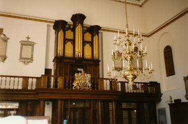
... historic London Mission. Part of a collection of Hasting Memorabilia collected by Keith and Pat Dann over a number of years. Prior to helping set up Hastings mission Keith Dann was also an active member at 717 Flinders St Mission. st michael paternoster royal london-uk organ mission to seafarers Photograph of a chapel interior with large pipe organ and wall plaques Photograph Photograph, Colour ...St Michael Paternoster Royal accommodates the offices of the central Mission to Seafarers in London. Obtained during a visit by Keith and Pat Dann to the Uk and historic London Mission.Part of a collection of Hasting Memorabilia collected by Keith and Pat Dann over a number of years. Prior to helping set up Hastings mission Keith Dann was also an active member at 717 Flinders St Mission.Photograph of a chapel interior with large pipe organ and wall plaquesst michael paternoster royal, london-uk, organ, mission to seafarers -
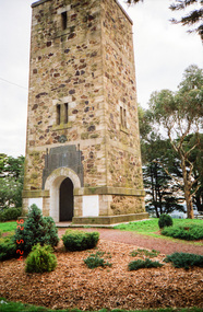
 Eltham District Historical Society Inc
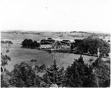
Photograph, View of Kangaroo Ground District from War Memorial Tower, 16 November 1951, 16 Nov. 1951
... plaque before a crowd of 500 people There was some concern in the 1960s when the Forests Commission wanted to build a firespotters cabin on the top. At first R.S.L. branches opposed the idea, but it was realised that this use could combine with its use as a tourist attraction, and would ensure its maintenance for the future. Today the Kangaroo Ground tower provides one of the best views around Melbourne and is a fitting memorial to those who died in two world wars. From: Historic...plaque before a crowd of 500 people There was some concern in the 1960s when the Forests Commission wanted to build a firespotters cabin on the top. At first R.S.L. branches opposed the idea, but it was realised that this use could combine with its use as a tourist attraction, and would ensure its maintenance for the future. Today the Kangaroo Ground tower provides one of the best views around Melbourne and is a fitting memorial to those who died in two world wars. From: Historic ...View from Shire of Eltham War Memorial tower at Garden Hill, Kangaroo Ground, probably taken shortly after the memorial's re-dedication held 8 Nov. 1951. On November 11th 1926 the Shire of Eltham War Memorial Tower at Kangaroo Ground was opened. It is regarded as one of Melbourne’s most outstanding lookout towers. It commands a magnificent 360 degree panorama from Kinglake across the Diamond Valley to Macedon and the You Yangs. It is built on a peak which was once a volcano, 237 metres above sea level. After World War one a memorial cairn was erected on the site, and in 1925 a committee of public-minded citizens began to plan for a tower. Many generous donations of material and money were forthcoming so that in 1926 the Governor General Lord Stonehaven was able to unveil the plaque before a crowd of 500 people There was some concern in the 1960s when the Forests Commission wanted to build a firespotters cabin on the top. At first R.S.L. branches opposed the idea, but it was realised that this use could combine with its use as a tourist attraction, and would ensure its maintenance for the future. Today the Kangaroo Ground tower provides one of the best views around Melbourne and is a fitting memorial to those who died in two world wars. From: Historic items for Diamond Valley Community Radio September 1990 (EDHS collection) On November 8th, 1951, the memorial was re-dedicated by the Governor of Victoria, Sir Dallas Brookes with the addition of the names of men from the Shire of Eltham who fell in the Second World War. Further wreaths were added in time for the 2001 Reembrance Day service to commemorate the men from th shire who had fallen in the Malayan, Korean, Borneo and Vietnam campaigns.This photo forms part of a collection of photographs gathered by the Shire of Eltham for their centenary project book,"Pioneers and Painters: 100 years of the Shire of Eltham" by Alan Marshall (1971). The collection of over 500 images is held in partnership between Eltham District Historical Society and Yarra Plenty Regional Library (Eltham Library) and is now formally known as the 'The Shire of Eltham Pioneers Photograph Collection.' It is significant in being the first community sourced collection representing the places and people of the Shire's first one hundred years.Digital image 120 format B&W negative B&W Print 12.5 x 17.5 cmsepp, shire of eltham pioneers photograph collection, kangaroo ground, garden hill, kangaroo ground tower, lookout, memorial park, panorama, shire of eltham war memorial, view, vista -
 Eltham District Historical Society Inc
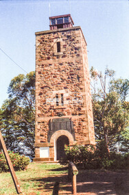
Negative - Photograph, Russell Yeoman, Shire of Eltham War Memorial, Memorial Park, Garden Hill, Eltham-Yarra Glen Road, Kangaroo Ground, c.1980
... plaque before a crowd of 500 people There was some concern in the 1960s when the Forests Commission wanted to build a firespotters cabin on the top. At first R.S.L. branches opposed the idea, but it was realised that this use could combine with its use as a tourist attraction, and would ensure its maintenance for the future. Today the Kangaroo Ground tower provides one of the best views around Melbourne and is a fitting memorial to those who died in two world wars. From: Historic...plaque before a crowd of 500 people There was some concern in the 1960s when the Forests Commission wanted to build a firespotters cabin on the top. At first R.S.L. branches opposed the idea, but it was realised that this use could combine with its use as a tourist attraction, and would ensure its maintenance for the future. Today the Kangaroo Ground tower provides one of the best views around Melbourne and is a fitting memorial to those who died in two world wars. From: Historic ...Shire of Eltham War Memorial Tower at Kangarooo Ground; view from the east and close up of entrance including Honour Roll. On November 11th 1926 the Shire of Eltham War Memorial Tower at Kangaroo Ground was opened. It is regarded as one of Melbourne’s most outstanding lookout towers. It commands a magnificent 360 degree panorama from Kinglake across the Diamond Valley to Macedon and the You Yangs. It is built on a peak which was once a volcano, 237 metres above sea level. After World War one a memorial cairn was erected on the site, and in 1925 a committee of public-minded citizens began to plan for a tower. Many generous donations of material and money were forthcoming so that in 1926 the Governor General Lord Stonehaven was able to unveil the plaque before a crowd of 500 people There was some concern in the 1960s when the Forests Commission wanted to build a firespotters cabin on the top. At first R.S.L. branches opposed the idea, but it was realised that this use could combine with its use as a tourist attraction, and would ensure its maintenance for the future. Today the Kangaroo Ground tower provides one of the best views around Melbourne and is a fitting memorial to those who died in two world wars. From: Historic items for Diamond Valley Community Radio September 1990 (EDHS collection) On November 8th, 1951, the memorial was re-dedicated by the Governor of Victoria, Sir Dallas Brooks with the addition of the names of men from the Shire of Eltham who fell in the Second World War. Further wreaths were added subsequent to this image in time for the 2001 Reembrance Day service to commemorate the men from th shire who had fallen in the Malayan, Korean, Borneo and Vietnam campaigns.Roll of 35mm colour negative film, 2 strips Colour print (x1)Kodak Safety 5035garden hill, kangaroo ground, kangaroo ground memorial, memorial park, shire of eltham war memorial tower, war memorial, garden hill, kangaroo ground, kangaroo ground memorial, kangaroo ground relief committee, memorial park, shire of eltham war memorial tower, war memorial, shire of eltham war memorial -
 Eltham District Historical Society Inc
Photograph, Shire of Eltham War Memorial, Memorial Park, Garden Hill, Kangaroo Ground; Eltham Heritage Tour, 24 May 1992, 24/05/1992
... plaque before a crowd of 500 people. There was some concern in the 1960s when the Forests Commission wanted to build a firespotters cabin on the top. At first R.S.L. branches opposed the idea, but it was realised that this use could combine with its use as a tourist attraction, and would ensure its maintenance for the future, Today the Kangaroo Ground tower provides one of the best views around Melbourne and is a fitting memorial to those who died in two world wars. From: Historic...plaque before a crowd of 500 people. There was some concern in the 1960s when the Forests Commission wanted to build a firespotters cabin on the top. At first R.S.L. branches opposed the idea, but it was realised that this use could combine with its use as a tourist attraction, and would ensure its maintenance for the future, Today the Kangaroo Ground tower provides one of the best views around Melbourne and is a fitting memorial to those who died in two world wars. From: Historic ...ELTHAM HERITAGE TOUR The Society excursion on 24th May 1992 was arranged by David Bick, leader of the team carrying out the Shire's heritage study. David selected a number of sites or buildings identified in the study, some of them lesser known components of the Shire's heritage. The tour commenced at the Eltham Shire Office at 10.00 am. Travel was by private car and mini-bus with stops at about twelve locations for commentary by David.It included a short walk in Hurstbridge and lunch at Kinglake. Highlights of the tour included: - 10 am Leave from Shire Offices - 3 Important Trees - A Physical Link to Eltham's First Settlers - Toorak Mansion Gates - A Surviving Farm House - An Intact Circa 1900 Main Street - First Settlers - Gold Miners, and Timber-getters - An Early Hotel - A Pioneering Homestead - Changing Eltham Shire - 20th Century - 4 pm Afternoon Tea and Finish Tour Extract from ELTHAM CULTURAL HERITAGE TOUR (Newsletter No. 85, July 1992, by Bettina Woodburn) "Now we drove through stands of pines to the Kangaroo Ground Lookout Tower, a most unusual War Memorial, World War I. The tower and a shed/residence (it had a chimney) were built from local sandstone. Below to the south and east of Melbourne spread 'suburbia'. Close by the landscape seemed so contrived - English fields and hedgerows! Although only about twenty inches deep, the soil of this ancient volcano, its crater lost under subsequent weathering, was rich, deserving the name of "Garden Hill". Now native trees are taking over again. In Kangaroo Ground itself stand the inevitable Store, School and Church - and two Norfolk pines and a monkey puzzle tree." On November 11th 1926 the Shire of Eltham War Memorial Tower at Kangaroo Ground was opened. It is regarded as one of Melbourne’s most outstanding lookout towers. It commands a magnificent 360 degree panorama from Kinglake across the Diamond Valley to Macedon and the You Yangs. It is built on a peak which was once a volcano, 237 metres above sea level. After World War one a memorial cairn was erected on the site, and in 1925 a committee of public-minded citizens began to plan for a tower. Many generous donations of material and money were forthcoming so that in 1926 the Governor General Lord Stonehaven was able to unveil the plaque before a crowd of 500 people. There was some concern in the 1960s when the Forests Commission wanted to build a firespotters cabin on the top. At first R.S.L. branches opposed the idea, but it was realised that this use could combine with its use as a tourist attraction, and would ensure its maintenance for the future, Today the Kangaroo Ground tower provides one of the best views around Melbourne and is a fitting memorial to those who died in two world wars. From: Historic items for Diamond Valley Community Radio September 1990 (EDHS collection) Record of the Society's history and activities and highlighting various aspects of the Heritage Study undertaken by David Bick used to create the future heritage overlay for the Shire of Eltham and later Nillumbik Shire.Roll of 35mm colour negative film, 4 stripsKodak Gold 100 5095culture, events, garden hill, kangaroo ground, kangaroo ground memorial, memorial park, shire of eltham war memorial tower, war memorials -
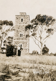 Eltham District Historical Society Inc
Photograph, Shire of Eltham War Memorial, Memorial Park, Garden Hill, Eltham-Yarra Glen Road, Kangaroo Ground, c.1936, 1936c
... plaque before a crowd of 500 people There was some concern in the 1960s when the Forests Commission wanted to build a firespotters cabin on the top. At first R.S.L. branches opposed the idea, but it was realised that this use could combine with its use as a tourist attraction, and would ensure its maintenance for the future. Today the Kangaroo Ground tower provides one of the best views around Melbourne and is a fitting memorial to those who died in two world wars. From: Historic...plaque before a crowd of 500 people There was some concern in the 1960s when the Forests Commission wanted to build a firespotters cabin on the top. At first R.S.L. branches opposed the idea, but it was realised that this use could combine with its use as a tourist attraction, and would ensure its maintenance for the future. Today the Kangaroo Ground tower provides one of the best views around Melbourne and is a fitting memorial to those who died in two world wars. From: Historic ...On November 11th 1926 the Shire of Eltham War Memorial Tower at Kangaroo Ground was opened. It is regarded as one of Melbourne’s most outstanding lookout towers. It commands a magnificent 360 degree panorama from Kinglake across the Diamond Valley to Macedon and the You Yangs. It is built on a peak which was once a volcano, 237 metres above sea level. After World War one a memorial cairn was erected on the site, and in 1925 a committee of public-minded citizens began to plan for a tower. Many generous donations of material and money were forthcoming so that in 1926 the Governor General Lord Stonehaven was able to unveil the plaque before a crowd of 500 people There was some concern in the 1960s when the Forests Commission wanted to build a firespotters cabin on the top. At first R.S.L. branches opposed the idea, but it was realised that this use could combine with its use as a tourist attraction, and would ensure its maintenance for the future. Today the Kangaroo Ground tower provides one of the best views around Melbourne and is a fitting memorial to those who died in two world wars. From: Historic items for Diamond Valley Community Radio September 1990 (EDHS collection) On November 8th, 1951, the memorial was re-dedicated by the Governor of Victoria, Sir Dallas Brooks with the addition of the names of men from the Shire of Eltham who fell in the Second World War. Further wreaths were added subsequent to this image in time for the 2001 Reembrance Day service to commemorate the men from th shire who had fallen in the Malayan, Korean, Borneo and Vietnam campaigns. Sepia photograph showing two ladies standing in front of the towergarden hill, kangaroo ground, kangaroo ground memorial, memorial park, shire of eltham war memorial tower, war memorial -
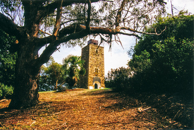 Eltham District Historical Society Inc
Photograph, War Memorial Tower, Kangaroo Ground
... plaque before a crowd of 500 people. There was some concern in the 1960s when the Forests Commission wanted to build a firespotters cabin on the top. At first R.S.L. branches opposed the idea, but it was realised that this use could combine with its use as a tourist attraction, and would ensure its maintenance for the future, Today the Kangaroo Ground tower provides one of the best views around Melbourne and is a fitting memorial to those who died in two world wars. From: Historic...plaque before a crowd of 500 people. There was some concern in the 1960s when the Forests Commission wanted to build a firespotters cabin on the top. At first R.S.L. branches opposed the idea, but it was realised that this use could combine with its use as a tourist attraction, and would ensure its maintenance for the future, Today the Kangaroo Ground tower provides one of the best views around Melbourne and is a fitting memorial to those who died in two world wars. From: Historic ...View of Kangaroo Ground Tower from the entrance gate area beside the footpath (Contained in an album originally put together by Harry Gilham. Photos subsequently relocated to photosafe archival storage.) On November 11th 1926 the Shire of Eltham War Memorial Tower at Kangaroo Ground was opened. It is regarded as one of Melbourne’s most outstanding lookout towers. It commands a magnificent 360 degree panorama from Kinglake across the Diamond Valley to Macedon and the You Yangs. It is built on a peak which was once a volcano, 237 metres above sea level. After World War one a memorial cairn was erected on the site, and in 1925 a committee of public-minded citizens began to plan for a tower. Many generous donations of material and money were forthcoming so that in 1926 the Governor General Lord Stonehaven was able to unveil the plaque before a crowd of 500 people. There was some concern in the 1960s when the Forests Commission wanted to build a firespotters cabin on the top. At first R.S.L. branches opposed the idea, but it was realised that this use could combine with its use as a tourist attraction, and would ensure its maintenance for the future, Today the Kangaroo Ground tower provides one of the best views around Melbourne and is a fitting memorial to those who died in two world wars. From: Historic items for Diamond Valley Community Radio September 1990 (EDHS collection) Colour photographgarden hill, kangaroo ground, memorial park, shire of eltham war memorial, shire of eltham war memorial tower, war memorial tower