Showing 5515 items matching "historical map"
-
 Phillip Island and District Historical Society Inc.
Book, RMIT Cartography, Phillip Island : historical map series, 1991
... Phillip Island : historical map series...Phillip Island : historical map series Book RMIT Cartography ...Stamped 'Phillip Island & District Historical Society'. -
 Greensborough Historical Society
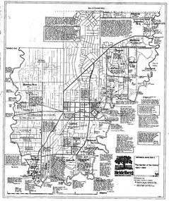
Map, Heidelberg: Historic River Landscape Assessment. Historical Maps. Map B 1838-1851, "The Distinctly aristocratic locality", 1985c
... Heidelberg: Historic River Landscape Assessment. Historical Maps. Map B 1838-1851, "The Distinctly aristocratic locality"... Black and white sketch map on white paper Heidelberg: Historic River Landscape Assessment. Historical Maps. Map B 1838-1851, "The Distinctly aristocratic locality" Map Loder & Bayley Loder & Bayley ...Geographical area of around 35 sq. kilometres marked with physical features such as major roads, rivers, vegetation and properties, with contemporary notes on landowners, descriptions and comments on the land and its development. Bounded by Shire of Diamond Valley to the North, Darebin Creek to the West and Plenty River to the EastBlack and white sketch map on white paperheidelberg, heidelberg - maps -
 Greensborough Historical Society
Map, Heidelberg. Historic River Landscape Assessment. Historical maps: Map C 1851-1863. "The Garden of the colony", 1985c
... Historic River Landscape Assessment. Historical maps: Map C 1851-1863. "The Garden of the colony"...Historic River Landscape Assessment. Historical maps: Map C 1851-1863. "The Garden of the colony" Map Loder & Bayley Loder & Bayley ...Geographical area of around 35 sq. kilometres marked with physical features such as major roads, vegetation and properties, with locations and notes of the increasing number of farms, gardens orchards and vineyards which had become established in addition to pastoral runs. Bounded by Shire of Diamond Valley to the North, Darebin Creek to the West and Plenty River to the East.Black and white sketch map on white paperheidelberg, heidelberg - maps -
 Greensborough Historical Society
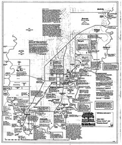
Map, Heidelberg: Historic River Landscape Assessment. Historical maps. Map D 1864 -1901 "Sleepy Hollow" and "Sleeping beauty", 1985c
... Heidelberg: Historic River Landscape Assessment. Historical maps. Map D 1864 -1901 "Sleepy Hollow" and "Sleeping beauty"...Second copy 600 x 430 cm printed in black on semi-opaque paper Heidelberg: Historic River Landscape Assessment. Historical maps. Map D 1864 -1901 "Sleepy Hollow" and "Sleeping beauty" Map Loder & Bayley Loder & Bayley ...Geographical area of c. 35 sq. kilometres marked with physical features such as major roads, rivers, vegetation and properties, with locations and notes on the increasing number of farms, orchards and vineyards that had been developed in addition to pastoral runs. Bounded by Shire of Diamond Valley to the North, Darebin Creek to the West, and Plenty River to the East.Black and white sketch on white paper. Second copy 600 x 430 cm printed in black on semi-opaque paperheidelberg, heidelberg - maps -
 Greensborough Historical Society
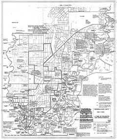
Map, Heidelberg: Historic River Landscape Assessment. Historical maps. Map E 1901-1934 "A Time of projects and improvements", 1985c
... Heidelberg: Historic River Landscape Assessment. Historical maps. Map E 1901-1934 "A Time of projects and improvements"... Black and white sketch map on white paper Heidelberg: Historic River Landscape Assessment. Historical maps. Map E 1901-1934 "A Time of projects and improvements" Map Loder & Bayley Loder & Bayley ...Geographical area of around 35 sq. kilometres marked with physical features such as major roads, railways (new extension to Eltham), rivers and properties, also housing sub-divisions and community facilities such as hospitals, parks and sporting reserves and indications of new small scale industries such as dairying. Bounded by Shire of Diamond Valley to the North, Darebin Creek to the West and Plenty River to the East. Black and white sketch map on white paperheidelberg, heidelberg - maps -
 Greensborough Historical Society
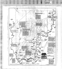
Poster - Map, Heidelberg: Historic River Landscape Assessment, Historical Maps. Map A To 1838. Country of the Wawarang, 1985c
... Heidelberg: Historic River Landscape Assessment, Historical Maps. Map A To 1838. Country of the Wawarang...Bounded by Shire of Diamond Valley to the North, Darebin Creek to the West and Plenty River to the East. heidelberg heidelberg - maps Black an white sketch map on white paper Heidelberg: Historic River Landscape Assessment, Historical Maps. Map A To 1838. Country of the Wawarang Poster Map Loder & Bayley Loder & Bayley ...Geographical area of around 35 sq. kilometres marked with physical features such as major roads, rivers, vegetation and properties, with contemporary notes on landowners, descriptions and comments on the land and its development. Bounded by Shire of Diamond Valley to the North, Darebin Creek to the West and Plenty River to the East.Black an white sketch map on white paperheidelberg, heidelberg - maps -
Whitehorse Historical Society Inc.
Document, Historical maps and plans, 1855 1889
... Copy of catalogue of historical maps and plans - Crown Lands Department...Whitehorse Historical Society Inc. 2-10 Deep Creek Road Mitcham melbourne Maps Historical maps Copy of catalogue of historical maps and plans - Crown Lands Department Copy of catalogue of historical maps and plans - Crown Lands Department Historical maps and plans Document Document ...Copy of catalogue of historical maps and plans - Crown Lands DepartmentCopy of catalogue of historical maps and plans - Crown Lands DepartmentCopy of catalogue of historical maps and plans - Crown Lands Departmentmaps, historical maps -
Clunes Museum
Map, A.C. BROOKS GOVERNMENT PRINTER MELBOURNE, EGLINTON COUNTY OF TALBOT, 1965
... ...HISTORICAL MAP...Clunes Museum 36 Fraser Street enter building through Collins Place Clunes goldfields MAP OF EGLINTON EGLINTON HISTORICAL MAP ADMINISTRATIVE STAMP ON BOTTOM LEFT AND ON THE BACK OF THE MAP ANOTHER STAMP - NORTHERN DIVISION (299) FORESTS COMMISSION BENDIGO MAP OF EGLINTON, COUNTY OF TALBOT PRINTED ON CANVAS WITH PLASTIC TAB FOR HANGING. ...MAP OF EGLINTONMAP OF EGLINTON, COUNTY OF TALBOT PRINTED ON CANVAS WITH PLASTIC TAB FOR HANGING. MAP SHOWS TOWN ALLOTMENTSADMINISTRATIVE STAMP ON BOTTOM LEFT AND ON THE BACK OF THE MAP ANOTHER STAMP - NORTHERN DIVISION (299) FORESTS COMMISSION BENDIGOeglinton, historical map -
 Bendigo Historical Society Inc.
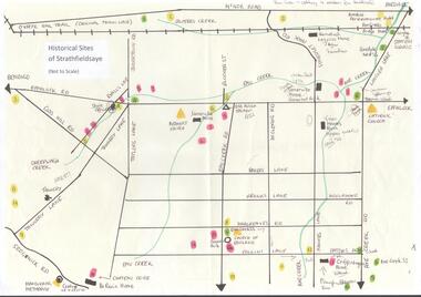
Map - MAP OF HISTORICAL SITES OF STRATHFIELDSAYE
... MAP OF HISTORICAL SITES OF STRATHFIELDSAYE...On one side a map of the historical sites of Strathfieldsaye (not to scale) and on the other ten photographs of people and sites and a list of the sites marked on the map....Map MAP OF HISTORICAL SITES OF STRATHFIELDSAYE ...On one side a map of the historical sites of Strathfieldsaye (not to scale) and on the other ten photographs of people and sites and a list of the sites marked on the map.bendigo, history, strathfieldsaye -
 Mont De Lancey
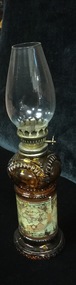
Lamp - Kerosene
... Lamp has clear glass chimney, an amber glass reservoir with historical map design and amber glass base. One screw at side to adjust the flame. 2. ...Lamp has clear glass chimney, an amber glass reservoir with historical map design and amber glass base. One screw at side to adjust the flame. 2. ...1. Lamp has clear glass chimney, an amber glass reservoir with historical map design and amber glass base. One screw at side to adjust the flame. 2. Small blue glass night light with glass chimney.kerosene lamps, lamps -
Canterbury History Group
Map - Logan Estate, Canterbury
... Real estate advertisement distributed by Sinclair & Company of a reproduction of a historical map of the Logan Estate and a short history on the reverse side....Canterbury History Group 190A Canterbury Road Canterbury melbourne Real estate advertisement distributed by Sinclair & Company of a reproduction of a historical map of the Logan Estate and a short history on the reverse side. ...Real estate advertisement distributed by Sinclair & Company of a reproduction of a historical map of the Logan Estate and a short history on the reverse side.canterbury, logan estate, canterbury road, prospect hill road, marlowe street, logan street, canterbury railway station, logan family, clairmont estate, molesworth street, sinclair & co -
Broadmeadows Historical Society & Museum
Map - Map of Australia, John Bartholomew & Son Ltd, Contour- coloured world map series: Australia, c. 1955
... Map...Historical information...Broadmeadows Historical Society & Museum 21 Pearcedale Parade Broadmeadows melbourne Printed 1955 Quality Map in good condition, can be used for research purposes Australia Map Historical information Education Map of Australia - Colour contoured - printed on cloth, scale 1:5,000,000 Contour- coloured world map series: Australia Map Map of Australia John Bartholomew & Son Ltd Mr. ...Printed 1955Quality Map in good condition, can be used for research purposesMap of Australia - Colour contoured - printed on cloth, scale 1:5,000,000australia, map, historical information, education -
 Whitehorse Historical Society Inc.
Map - Civic Map, Subdivision of Village of Springfield, 1861
... Historical civic map of the Nunawading area....Whitehorse Historical Society Inc. 2-10 Deep Creek Road Mitcham melbourne Historical civic map of the Nunawading area. Early subdivision map of the Nunawading area, part of the Vale Collection of Maps in the LaTrobe Library. ...Map of the subdivision of the Springfield Estate, Nunawading, 1861. The Springfield Estate was located in the Northwest corner of Whitehorse Road and Springvale Road.Map of the subdivision of the Springfield Estate, Nunawading, 1861. Springfield Estate was located in the Northwest corner of Whitehorse Road and Springvale Road.non-fictionMap of the subdivision of the Springfield Estate, Nunawading, 1861. The Springfield Estate was located in the Northwest corner of Whitehorse Road and Springvale Road.springfield estate, whitehorse road nunawading, springvale road nunawading -
 Mont De Lancey
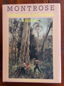
Book, Jennifer McLennan, Montrose - Settlement in the Foothills A History, 1987
... The book offers a detailed account of the development of Montrose, Victoria, from its pioneering days through to the late 20th century, featuring historical maps, photos, and insights into early community life....The book offers a detailed account of the development of Montrose, Victoria, from its pioneering days through to the late 20th century, featuring historical maps, photos, and insights into early community life. ...This is a local history book by Jennifer McLennan, published in 1987 by the Shire of Lilydale. The book offers a detailed account of the development of Montrose, Victoria, from its pioneering days through to the late 20th century, featuring historical maps, photos, and insights into early community life.A brown book with an orange dust jacket which has a large coloured photograph on the front of a painting 'Tree Felling in the Dandenongs' by Victor Zelman.The title is printed at the top in brown and yellow lettering with the author's name in yellow at the bottom. The spine has the title, author and publisher as does the title page.The endpapers show brown subdivisions and a map of the area. Inside is a Contents, Preface, Chapters detailing all the settlement and history of the area from the mid 1800's, Footnotes, Acknowledgements, Select Bibliography and an Index. Copies of land titles, some coloured prints of paintings, illustrations, photographs fill the book. Pp.112.montrose - history, dandenongs - history, victoria - history -
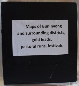 Buninyong Visitor Information Centre
Document (item) - Information Folder, Maps of Buninyong and Surrounding Districts, 1990s
... Black vinyl covered ring binder with plastic pockets containing maps and historical articles....Maps Mapping Buninyong Black vinyl covered ring binder with plastic pockets containing maps and historical articles. Maps of Buninyong and Surrounding Districts Document Information Folder ...Collection of maps and copies of maps of the Buninyong district.maps, mapping, buninyong -
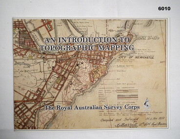 Bendigo Military Museum
Pamphlet - An Introduction to Topographic Mapping, C 1991
... This is a Royal Australian Survey Corp pamphlet with a historical map printed in colour on cardboard on both sides of the cover. ...Royal Australian Survey Corps RASvy Fortuna Army Survey Regiment Army Svy Regt ASR This is a Royal Australian Survey Corp pamphlet with a historical map printed in colour on cardboard on both sides of the cover. ...This pamphlet was published by the Army Survey Regiment as an overview of the Royal Australian Survey Corps (RASvy), its role and unit structure circa 1991, prior to RASvy’s disbandment in 1996. The pamphlet comprehensively detailed the eight steps of topographic map production: Establish Survey Control, Aerial Photography, Aerotriangulation, Stereoplotting, Field Verification, Cartography, Printing and Storage/Map Distribution. Leading technologies used by RA Svy in 1991 included GPS control surveys, 5 colour printing on the Speedmaster offset press and bulk map packaging using the Map Handling Station (with guillotine). Digital map production was operating on the AUTOMAP 2 system, before the “Newheart” system upgrade two years later. Printed on the pamphlet cover was a portion of the plane tabled “four inches to a mile” map of Newcastle. This was compiled and surveyed in 1910 by LCPL A. Barrett, a member of the RAE Detachment, as part of the first major topographic mapping effort of Australia.This is a Royal Australian Survey Corp pamphlet with a historical map printed in colour on cardboard on both sides of the cover. There are 16 pages printed in colour on gloss paper, with photos, diagrams and descriptions. The pamphlet is bounded by two staples on its spine. Each of the 17 images were scanned at 300 dpi in JPEG (.jpg) format and stored on the attached 16 Gb USB memory stick. The images have been converted into MPEG-4 (.mp4) video format, 4Mb in size and runs for 2:16 minutes and is also stored on the memory stick.royal australian survey corps, rasvy, fortuna, army survey regiment, army svy regt, asr -
Federation University Historical Collection
Pamphlet, Fletcher and Son Ltd, History on Display
... Images and backgrounds histories and historical features/ Has a map of museum's location, as well as assitional information....Barker Library (top floor) Mount Helen goldfields Ballarat historical society museum Images and backgrounds histories and historical features/ Has a map of museum's location, as well as assitional information. ...Images and backgrounds histories and historical features/ Has a map of museum's location, as well as assitional information.ballarat historical society, museum -
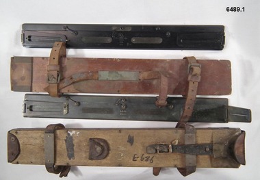 Bendigo Military Museum
Instrument - Plane Table Surveying - Simple Alidade, ER Watts and Son, London, 1938
... The Plane Table Alidade was used as the sighting Instrument in the production of historical manual hand drawn maps. A Plane Table Board mounted on a tripod is levelled and the Alidade is placed on the table with the vanes perpendicular to the it. ...Two Plane Table sighting instruments (Alidade) used for historical manual map making housed in wooden transit boxes. ...Two Plane Table sighting instruments (Alidade) used for historical manual map making housed in wooden transit boxes. ...The Plane Table Alidade was used as the sighting Instrument in the production of historical manual hand drawn maps. A Plane Table Board mounted on a tripod is levelled and the Alidade is placed on the table with the vanes perpendicular to the it. Each sighting vane has a central thread lined up on the target and the angle to that target point is then drawn on the map sheet using the beveled fiducial edge. Plane Table Surveying is used as a quick method where less accuracy is required or needed. Plane table Surveying is a relatively portable and inexpensive method and was used extensively before the advent of sophisticated surveying instruments. The photo at 6489.2 is an Australian Army Survey Corps Party using a Plane Table Alidade in Syria during WWII. See also item 6580 which is the Plane Table with tripod legs that was used with the Alidade.Two Plane Table sighting instruments (Alidade) used for historical manual map making housed in wooden transit boxes. A brass instrument with folding sights at each end and a beveled fiducial edge in one edge. The front sight is the object vane and the rear sight is the sight vane. There is a sliding arm attached to the base to draw parallel lines to the fiducial edge. Very slight differences in model between these two instruments.First Instrument, "ER Watts and Son, London, 1938, MkII, Box Label 423. Second Instrument - R. E-Co, Mk.II, stamped E686, Box Label 686.royal australian survey corps, rasvy, fortuna, army survey regiment, army svy regt, asr -
Lakes Entrance Historical Society
Book, Tourist Development Authority of Victoria, Victorias 15 National Parks, 1956
... Illustrated with photographic reproductions and locality map. Historically significant because of the time period....Lakes Entrance Historical Society 4 Marine Parade Lakes Entrance gippsland Parks Natural History Crown Lands Tourism This booklet contains a description of the 15 proclaimed Victorian National Parks as at 1956. Illustrated with photographic reproductions and locality map ...This booklet contains a description of the 15 proclaimed Victorian National Parks as at 1956. Illustrated with photographic reproductions and locality map. Historically significant because of the time period.parks, natural history, crown lands, tourism -
Tatura Irrigation & Wartime Camps Museum
Folio, James Winter of Dhurringile, 1994
... Historical report illustrated by maps and written material from various sources...Tatura Irrigation & Wartime Camps Museum 49 Hogan Street Tatura the-murray Historical report illustrated by maps and written material from various sources dhurringile documents reports Folder containing information on James Winter of Dhurringile. ...Historical report illustrated by maps and written material from various sourcesFolder containing information on James Winter of Dhurringile.dhurringile, documents, reports -
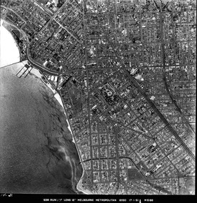
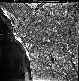
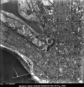 St Kilda Historical Society
Photograph - Photo map, 28/01/1951
... For correlation with a current map, and access to other historical photo maps of Victoria, see the Historic Photo-Maps Index published by the Department of Environment, Land, Water and Planning at https://services.land.vic.gov.au/DELWPmaps/historical-photomaps/...For correlation with a current map, and access to other historical photo maps of Victoria, see the Historic Photo-Maps Index published by the Department of Environment, Land, Water and Planning at https://services.land.vic.gov.au/DELWPmaps/historical-photomaps/ Albert Park St Kilda Junction St Kilda Pier Catani Gardens St Kilda Prahran Albert Park Lake 1951 Middle Park St Kilda Beach Windsor 1424-45 SECRET 534 Run 18 Lens 12" Melbourne Metropolitan 12150 28.1.51 M639 Black and white aerial photograph Photograph Photo map ...One of a series of photo-maps produced for the Department of Crown Lands and Survey (1857-1983). For correlation with a current map, and access to other historical photo maps of Victoria, see the Historic Photo-Maps Index published by the Department of Environment, Land, Water and Planning at https://services.land.vic.gov.au/DELWPmaps/historical-photomaps/Black and white aerial photograph1424-45 SECRET 534 Run 18 Lens 12" Melbourne Metropolitan 12150 28.1.51 M639albert park, st kilda junction, st kilda pier, catani gardens, st kilda, prahran, albert park lake, 1951, middle park, st kilda beach, windsor -
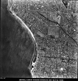
 St Kilda Historical Society
Photograph - Photo map, 17/01/1951
... For correlation with a current map, and access to other historical photo maps of Victoria, see the Historic Photo-Maps Index published by the Department of Environment, Land, Water and Planning at https://services.land.vic.gov.au/DELWPmaps/historical-photomaps/...For correlation with a current map, and access to other historical photo maps of Victoria, see the Historic Photo-Maps Index published by the Department of Environment, Land, Water and Planning at https://services.land.vic.gov.au/DELWPmaps/historical-photomaps/ St Kilda St Kilda botanical gardens Peanut farm Elwood 1951 Point Ormond Elwood canal St Kilda Beach 1414-21 538 Run 19 Lens 12" Melbourne Metropolitan 12150 17.1.51 M586 Black and white aerial photograph Photograph Photo map ...One of a series of photo-maps produced for the Department of Crown Lands and Survey (1857-1983). For correlation with a current map, and access to other historical photo maps of Victoria, see the Historic Photo-Maps Index published by the Department of Environment, Land, Water and Planning at https://services.land.vic.gov.au/DELWPmaps/historical-photomaps/Black and white aerial photograph1414-21 538 Run 19 Lens 12" Melbourne Metropolitan 12150 17.1.51 M586st kilda, st kilda botanical gardens, peanut farm, elwood, 1951, point ormond, elwood canal, st kilda beach -
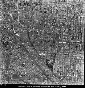
 St Kilda Historical Society
Photograph - Photo map, 28/01/1951
... For correlation with a current map, and access to other historical photo maps of Victoria, see the Historic Photo-Maps Index published by the Department of Environment, Land, Water and Planning at https://services.land.vic.gov.au/DELWPmaps/historical-photomaps/...For correlation with a current map, and access to other historical photo maps of Victoria, see the Historic Photo-Maps Index published by the Department of Environment, Land, Water and Planning at https://services.land.vic.gov.au/DELWPmaps/historical-photomaps/ Elwood Point Ormond Elwood Park Elsternwick Park Elwood Beach 1951 1424-118 534 Run 20 Lens 12" Melbourne Metropolitan 12150 18.1.51M639 Black and white aerial photograph Photograph Photo map ...One of a series of photo-maps produced for the Department of Crown Lands and Survey (1857-1983). For correlation with a current map, and access to other historical photo maps of Victoria, see the Historic Photo-Maps Index published by the Department of Environment, Land, Water and Planning at https://services.land.vic.gov.au/DELWPmaps/historical-photomaps/Black and white aerial photograph1424-118 534 Run 20 Lens 12" Melbourne Metropolitan 12150 18.1.51M639elwood, point ormond, elwood park, elsternwick park, elwood beach, 1951 -
 St Kilda Historical Society
Photograph - Photo map, 17/01/1951
... For correlation with a current map, and access to other historical photo maps of Victoria, see the Historic Photo-Maps Index published by the Department of Environment, Land, Water and Planning at https://services.land.vic.gov.au/DELWPmaps/historical-photomaps/...For correlation with a current map, and access to other historical photo maps of Victoria, see the Historic Photo-Maps Index published by the Department of Environment, Land, Water and Planning at https://services.land.vic.gov.au/DELWPmaps/historical-photomaps/ Elwood Elsternwick St Kilda East Balaclava Ripponlea 1951 1414-20 538 Run 19 Lens 12" Melbourne Metropolitan 12150 17.1.51 M586 Black and white aerial photograph Photograph Photo map ...One of a series of photo-maps produced for the Department of Crown Lands and Survey (1857-1983). For correlation with a current map, and access to other historical photo maps of Victoria, see the Historic Photo-Maps Index published by the Department of Environment, Land, Water and Planning at https://services.land.vic.gov.au/DELWPmaps/historical-photomaps/Black and white aerial photograph1414-20 538 Run 19 Lens 12" Melbourne Metropolitan 12150 17.1.51 M586elwood, elsternwick, st kilda east, balaclava, ripponlea, 1951 -
 St Kilda Historical Society
Photograph - Photo map, 28/01/1951
... For correlation with a current map, and access to other historical photo maps of Victoria, see the Historic Photo-Maps Index published by the Department of Environment, Land, Water and Planning at https://services.land.vic.gov.au/DELWPmaps/historical-photomaps/...For correlation with a current map, and access to other historical photo maps of Victoria, see the Historic Photo-Maps Index published by the Department of Environment, Land, Water and Planning at https://services.land.vic.gov.au/DELWPmaps/historical-photomaps/ 1424-44 534 Run 18 Lens 12" Melbourne Metropolitan 12150 28.1.51 M639 Black and white aerial photograph Photograph Photo map ...One of a series of photo-maps produced for the Department of Crown Lands and Survey (1857-1983). For correlation with a current map, and access to other historical photo maps of Victoria, see the Historic Photo-Maps Index published by the Department of Environment, Land, Water and Planning at https://services.land.vic.gov.au/DELWPmaps/historical-photomaps/Black and white aerial photograph1424-44 534 Run 18 Lens 12" Melbourne Metropolitan 12150 28.1.51 M639 -
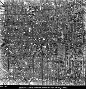
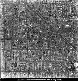 St Kilda Historical Society
Photograph - Photo map, 28/01/1951
... For correlation with a current map, and access to other historical photo maps of Victoria, see the Historic Photo-Maps Index published by the Department of Environment, Land, Water and Planning at https://services.land.vic.gov.au/DELWPmaps/historical-photomaps/...For correlation with a current map, and access to other historical photo maps of Victoria, see the Historic Photo-Maps Index published by the Department of Environment, Land, Water and Planning at https://services.land.vic.gov.au/DELWPmaps/historical-photomaps/ Armadale Malvern St Kilda cemetery Caulfield North St Kilda East 1951 1424-43 534 Run 18 Lens 12" Melbourne Metropolitan 12150 28.1.51 M639 Black and white aerial photograph Photograph Photo map ...One of a series of photo-maps produced for the Department of Crown Lands and Survey (1857-1983). For correlation with a current map, and access to other historical photo maps of Victoria, see the Historic Photo-Maps Index published by the Department of Environment, Land, Water and Planning at https://services.land.vic.gov.au/DELWPmaps/historical-photomaps/Black and white aerial photograph1424-43 534 Run 18 Lens 12" Melbourne Metropolitan 12150 28.1.51 M639armadale, malvern, st kilda cemetery, caulfield north, st kilda east, 1951 -
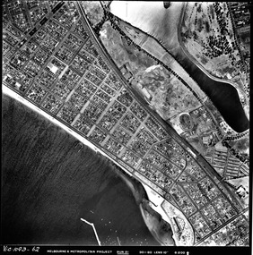 St Kilda Historical Society
Photograph - Photo map, 30/01/1960
... For correlation with a current map, and access to other historical photo maps of Victoria, see the Historic Photo-Maps Index published by the Department of Environment, Land, Water and Planning at https://services.land.vic.gov.au/DELWPmaps/historical-photomaps/...For correlation with a current map, and access to other historical photo maps of Victoria, see the Historic Photo-Maps Index published by the Department of Environment, Land, Water and Planning at https://services.land.vic.gov.au/DELWPmaps/historical-photomaps/ Middle Park Albert Park Catani Gardens St Kilda West 1960 Vic 1093-62 Melbourne & Metropolitan Project Run 21 30.1.60 Lens 10" 8.200 Black and white aerial photograph Photograph Photo map ...One of a series of photo-maps produced for the Department of Crown Lands and Survey (1857-1983). For correlation with a current map, and access to other historical photo maps of Victoria, see the Historic Photo-Maps Index published by the Department of Environment, Land, Water and Planning at https://services.land.vic.gov.au/DELWPmaps/historical-photomaps/Black and white aerial photographVic 1093-62 Melbourne & Metropolitan Project Run 21 30.1.60 Lens 10" 8.200middle park, albert park, catani gardens, st kilda west, 1960 -
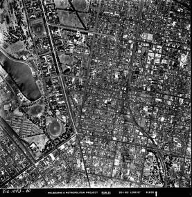 St Kilda Historical Society
Photograph - Photo map, 30/01/1960
... For correlation with a current map, and access to other historical photo maps of Victoria, see the Historic Photo-Maps Index published by the Department of Environment, Land, Water and Planning at https://services.land.vic.gov.au/DELWPmaps/historical-photomaps/...For correlation with a current map, and access to other historical photo maps of Victoria, see the Historic Photo-Maps Index published by the Department of Environment, Land, Water and Planning at https://services.land.vic.gov.au/DELWPmaps/historical-photomaps/ St Kilda Albert Park Prahran Windsor South Yarra 1960 Vic 1093-60 Melbourne & Metropolitan Project Run 21 30.1.60 Lens 10" 8.200 Black and white aerial photograph Photograph Photo map ...One of a series of photo-maps produced for the Department of Crown Lands and Survey (1857-1983). For correlation with a current map, and access to other historical photo maps of Victoria, see the Historic Photo-Maps Index published by the Department of Environment, Land, Water and Planning at https://services.land.vic.gov.au/DELWPmaps/historical-photomaps/Black and white aerial photographVic 1093-60 Melbourne & Metropolitan Project Run 21 30.1.60 Lens 10" 8.200st kilda, albert park, prahran, windsor, south yarra, 1960 -
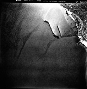 St Kilda Historical Society
Photograph - Photo map, 30/01/1960
... For correlation with a current map, and access to other historical photo maps of Victoria, see the Historic Photo-Maps Index published by the Department of Environment, Land, Water and Planning at https://services.land.vic.gov.au/DELWPmaps/historical-photomaps/...For correlation with a current map, and access to other historical photo maps of Victoria, see the Historic Photo-Maps Index published by the Department of Environment, Land, Water and Planning at https://services.land.vic.gov.au/DELWPmaps/historical-photomaps/ St Kilda St Kilda pier St Kilda beach Catani Gardens 1960 Vic 1092-36 Melbourne & Metropolitan Project Run 22 30.1.60 Lens 10" 8.200 Black and white aerial photograph Photograph Photo map ...One of a series of photo-maps produced for the Department of Crown Lands and Survey (1857-1983). For correlation with a current map, and access to other historical photo maps of Victoria, see the Historic Photo-Maps Index published by the Department of Environment, Land, Water and Planning at https://services.land.vic.gov.au/DELWPmaps/historical-photomaps/Black and white aerial photographVic 1092-36 Melbourne & Metropolitan Project Run 22 30.1.60 Lens 10" 8.200st kilda, st kilda pier, st kilda beach, catani gardens, 1960 -
 St Kilda Historical Society
Photograph - Photo map, 30/01/1960
... For correlation with a current map, and access to other historical photo maps of Victoria, see the Historic Photo-Maps Index published by the Department of Environment, Land, Water and Planning at https://services.land.vic.gov.au/DELWPmaps/historical-photomaps/...For correlation with a current map, and access to other historical photo maps of Victoria, see the Historic Photo-Maps Index published by the Department of Environment, Land, Water and Planning at https://services.land.vic.gov.au/DELWPmaps/historical-photomaps/ St Kilda St Kilda beach St Kilda pier Catani gardens 1960 St Kilda Botanical Gardens Peanut farm Vic 1092-38 Melbourne & Metropolitan Project Run 22 30.1.60 Lens 10" 8.200 Black and white aerial photograph Photograph Photo map ...One of a series of photo-maps produced for the Department of Crown Lands and Survey (1857-1983). For correlation with a current map, and access to other historical photo maps of Victoria, see the Historic Photo-Maps Index published by the Department of Environment, Land, Water and Planning at https://services.land.vic.gov.au/DELWPmaps/historical-photomaps/Black and white aerial photographVic 1092-38 Melbourne & Metropolitan Project Run 22 30.1.60 Lens 10" 8.200st kilda, st kilda beach, st kilda pier, catani gardens, 1960, st kilda botanical gardens, peanut farm