Showing 489 items matching "infrastructure development"
-
 Eltham District Historical Society Inc
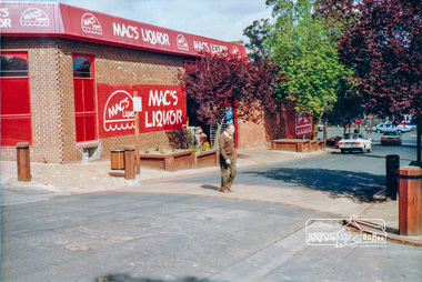
Photograph, Pedestrian access upgrade, Pryor Street, Eltham, c. Oct 1987
... ...infrastructure development...Shows upgraded footpath area with new paving and planter boxes eltham main road shire of eltham infrastructure development Colour photograph Pedestrian access upgrade, Pryor Street, Eltham, c. ...Looking down Pryor Street towards the intersection with Main Road, Mac's Liquor on left. Shows upgraded footpath area with new paving and planter boxesColour photographeltham, main road, shire of eltham, infrastructure development -
 Eltham District Historical Society Inc
Photograph, Pedestrian access upgrade, Pryor Street, Eltham, c. Oct 1987
... ...infrastructure development...Date based on other similar display panels visible in images of the Shire of Eltham display at the Eltham Community Festival, 7 November 1987. eltham main road shire of eltham infrastructure development Commercial Place Display panel Eltham Festival Mac's Liquor Pryor Street Colour photograph Pedestrian access upgrade, Pryor Street, Eltham, c. ...Looking down Pryor Street towards the intersection with Main Road, Mac's Liquor on left. Shows upgraded footpath area with new paving and planter boxes. Date based on other similar display panels visible in images of the Shire of Eltham display at the Eltham Community Festival, 7 November 1987.Colour photographeltham, main road, shire of eltham, infrastructure development, commercial place, display panel, eltham festival, mac's liquor, pryor street -
 Ballarat Heritage Services
Photograph - Photograph - Colour, Lisa Gervasoni, 'Eureka Circle' by Dr. Anton Hasell, 03/07/2013
... Commissioned by the City of Ballarat and the Victorian Government's Regional Infrastructure Development Fund. Unveiled by Premier Steve Bracks 26th November 2004....Commissioned by the City of Ballarat and the Victorian Government's Regional Infrastructure Development Fund. Unveiled by Premier Steve Bracks 26th November 2004. eureka stockade memorial gardens eureka circle eureka stockade sculpture Anton Hassell Colour photographs of a sculpture in the Eureka Stockade Memorial Gardens. ...Eureka Circle marks the 150th anniversary of the Eureka Rebellion, and captures its sacrifices, sense of noble cause and spirit of unity. Commissioned by the City of Ballarat and the Victorian Government's Regional Infrastructure Development Fund. Unveiled by Premier Steve Bracks 26th November 2004.Colour photographs of a sculpture in the Eureka Stockade Memorial Gardens.eureka stockade memorial gardens, eureka circle, eureka stockade, sculpture, anton hassell -
![Photograph - Colour, Clare Gervasoni, 'Eureka Circle' [detail] by Dr. Anton Hasell, 31/03/2013](/media/collectors/57a00a4fd0cdd1210422a51e/items/5d3ef8a921ea6716b032dc77/item-media/5d3ef8be21ea6716b03305f3/item-fit-380x285.jpg?cb=6) Ballarat Heritage Services
Ballarat Heritage ServicesPhotograph - Colour, Clare Gervasoni, 'Eureka Circle' [detail] by Dr. Anton Hasell, 31/03/2013
... Commissioned by the City of Ballarat and the Victorian Government's Regional Infrastructure Development Fund. Unveiled by Premier Steve Bracks 26th November 2004....Commissioned by the City of Ballarat and the Victorian Government's Regional Infrastructure Development Fund. Unveiled by Premier Steve Bracks 26th November 2004. eureka stockade memorial gardens eureka circle eureka stockade sculpture miltary soldier Colour photographs of a panel from sculpture in the Eureka Stockade Memorial Gardens. ...Eureka Circle marks the 150th anniversary of the Eureka Rebellion, and captures its sacrifices, sense of noble cause and spirit of unity. Commissioned by the City of Ballarat and the Victorian Government's Regional Infrastructure Development Fund. Unveiled by Premier Steve Bracks 26th November 2004.Colour photographs of a panel from sculpture in the Eureka Stockade Memorial Gardens.eureka stockade memorial gardens, eureka circle, eureka stockade, sculpture, miltary, soldier -
![Photograph - Colour, Clare Gervasoni, 'Eureka Circle' [detail] by Dr. Anton Hasell, 31/03/2013](/media/collectors/57a00a4fd0cdd1210422a51e/items/5d3ef94121ea6716b03355b9/item-media/5d3ef94e21ea6716b0336381/item-fit-380x285.jpg?cb=6) Ballarat Heritage Services
Ballarat Heritage ServicesPhotograph - Colour, Clare Gervasoni, 'Eureka Circle' [detail] by Dr. Anton Hasell, 31/03/2013
... Commissioned by the City of Ballarat and the Victorian Government's Regional Infrastructure Development Fund. Unveiled by Premier Steve Bracks 26th November 2004....Commissioned by the City of Ballarat and the Victorian Government's Regional Infrastructure Development Fund. Unveiled by Premier Steve Bracks 26th November 2004. eureka stockade memorial gardens eureka circle eureka stockade sculpture miltary soldier Colour photographs of a panel from sculpture in the Eureka Stockade Memorial Gardens. ...Eureka Circle marks the 150th anniversary of the Eureka Rebellion, and captures its sacrifices, sense of noble cause and spirit of unity. Commissioned by the City of Ballarat and the Victorian Government's Regional Infrastructure Development Fund. Unveiled by Premier Steve Bracks 26th November 2004.Colour photographs of a panel from sculpture in the Eureka Stockade Memorial Gardens.eureka stockade memorial gardens, eureka circle, eureka stockade, sculpture, miltary, soldier -
![Photograph - Colour, Clare Gervasoni, 'Eureka Circle' [detail] by Dr. Anton Hasell, 31/03/2013](/media/collectors/57a00a4fd0cdd1210422a51e/items/5d3ef98c21ea6716b033b82b/item-media/5d3ef9a521ea6716b033d770/item-fit-380x285.jpg?cb=6) Ballarat Heritage Services
Ballarat Heritage ServicesPhotograph - Colour, Clare Gervasoni, 'Eureka Circle' [detail] by Dr. Anton Hasell, 31/03/2013
... Commissioned by the City of Ballarat and the Victorian Government's Regional Infrastructure Development Fund. Unveiled by Premier Steve Bracks 26th November 2004....Commissioned by the City of Ballarat and the Victorian Government's Regional Infrastructure Development Fund. Unveiled by Premier Steve Bracks 26th November 2004. eureka stockade memorial gardens eureka circle eureka stockade sculpture digger Colour photographs of a panel from sculpture in the Eureka Stockade Memorial Gardens. ...Eureka Circle marks the 150th anniversary of the Eureka Rebellion, and captures its sacrifices, sense of noble cause and spirit of unity. Commissioned by the City of Ballarat and the Victorian Government's Regional Infrastructure Development Fund. Unveiled by Premier Steve Bracks 26th November 2004.Colour photographs of a panel from sculpture in the Eureka Stockade Memorial Gardens.eureka stockade memorial gardens, eureka circle, eureka stockade, sculpture, digger -
![Photograph - Colour, Clare Gervasoni, 'Eureka Circle' [detail] by Dr. Anton Hasell, 31/03/2013](/media/collectors/57a00a4fd0cdd1210422a51e/items/5d3efe7321ea6716b038183e/item-media/5d3efe7a21ea6716b0381e5e/item-fit-380x285.jpg?cb=6) Ballarat Heritage Services
Ballarat Heritage ServicesPhotograph - Colour, Clare Gervasoni, 'Eureka Circle' [detail] by Dr. Anton Hasell, 31/03/2013
... Commissioned by the City of Ballarat and the Victorian Government's Regional Infrastructure Development Fund. Unveiled by Premier Steve Bracks 26th November 2004....Commissioned by the City of Ballarat and the Victorian Government's Regional Infrastructure Development Fund. Unveiled by Premier Steve Bracks 26th November 2004. eureka stockade memorial gardens eureka circle eureka stockade sculpture digger Colour photographs of a panel from sculpture in the Eureka Stockade Memorial Gardens. ...Eureka Circle marks the 150th anniversary of the Eureka Rebellion, and captures its sacrifices, sense of noble cause and spirit of unity. Commissioned by the City of Ballarat and the Victorian Government's Regional Infrastructure Development Fund. Unveiled by Premier Steve Bracks 26th November 2004.Colour photographs of a panel from sculpture in the Eureka Stockade Memorial Gardens.eureka stockade memorial gardens, eureka circle, eureka stockade, sculpture, digger -
 Ballarat Heritage Services
Photograph - Colour, 'Eureka Circle' by Dr. Anton Hasell, 25/10/2018
... Commissioned by the City of Ballarat and the Victorian Government's Regional Infrastructure Development Fund. Unveiled by Premier Steve Bracks 26th November 2004....Commissioned by the City of Ballarat and the Victorian Government's Regional Infrastructure Development Fund. Unveiled by Premier Steve Bracks 26th November 2004. eureka stockade memorial gardens eureka circle eureka stockade sculpture Colour photographs of a sculpture in the Eureka Stockade Memorial Gardens. ...Eureka Circle marks the 150th anniversary of the Eureka Rebellion, and captures its sacrifices, sense of noble cause and spirit of unity. Commissioned by the City of Ballarat and the Victorian Government's Regional Infrastructure Development Fund. Unveiled by Premier Steve Bracks 26th November 2004.Colour photographs of a sculpture in the Eureka Stockade Memorial Gardens.eureka stockade memorial gardens, eureka circle, eureka stockade, sculpture -
 Nillumbik Shire Council
Public Art: Helen BODYCOMB (b.1964, South Australia) and Enver CAMDAL (Lives and works Turkey), Enver Camdal et al, Nest (Location: Roundabout, Main and Luck Street, Eltham), 1997
... Commissioned by Nillumbik Shire Council - 1997 The selection panel in the commissioning process to this 'extraordinary acquisition' was Rhonda Noble, Director of La Trobe University Museum of Art, Jeph Neale, Eltham Roundabout Advisory Group, Chris Marks, NSC Curator of Collections, Geoff Glynn, NSC Manager of Infrastructure Development....Nillumbik Shire Council melbourne Commissioned by Nillumbik Shire Council - 1997 The selection panel in the commissioning process to this 'extraordinary acquisition' was Rhonda Noble, Director of La Trobe University Museum of Art, Jeph Neale, Eltham Roundabout Advisory Group, Chris Marks, NSC Curator of Collections, Geoff Glynn, NSC Manager of Infrastructure Development. 'Nest' highlights the indigenous flora and fauna of the Shire. ...Commissioned by Nillumbik Shire Council - 1997 The selection panel in the commissioning process to this 'extraordinary acquisition' was Rhonda Noble, Director of La Trobe University Museum of Art, Jeph Neale, Eltham Roundabout Advisory Group, Chris Marks, NSC Curator of Collections, Geoff Glynn, NSC Manager of Infrastructure Development.'Nest' highlights the indigenous flora and fauna of the Shire. The stiff, coarse grass used to create the nest is indigenous to the area and the eggs are like those of the spotted quail thrush, a ground-nesting bird of the Shire. The circular flow or placement of the eggs recalls the revolution of the seasons and nesting cycles. There is a tall light pole above the eggs, shining down at night. The effect is of a giant incubator. Enrichment and nurturing of the larger environment can be associated with this sculpture. This work resembles a large bird's nest, with three egg-like forms of fibreglass covered in a pebble render, set on sand. The nest is positioned within the paved boundary of the roundabout. The nest shape has been created out of stiff, coarse indigenous grass, periodically trimmed so the view is not obstructed. The eggs are a brown-speckled, creamy yellow colour. The three eggs are arranged in a ring, with the narrow end of each pointing to the large end of the next, in a circle that mimics the flow of traffic. N/Apublic art, nest, eggs, eltham, ekphrasis2017, mosaic, pebbles, roundabout, spotted quail thrush -
 Ballarat Heritage Services
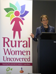
Photograph - Digital photographs, L.J. Gervasoni, Minister for Agriculture Jaala Pulford at Rural Women Uncovered 2017, September 2017
... Sponsors Victorian Farmers Federation, Agriculture Victoria, Rabo Bank, Chandler Agribusiness, Department of Infrastructure and Regional Development. What can we do to make a difference in the life of others. ...Sponsors Victorian Farmers Federation, Agriculture Victoria, Rabo Bank, Chandler Agribusiness, Department of Infrastructure and Regional Development. What can we do to make a difference in the life of others. ...Conference to empower rural women. Sponsors Victorian Farmers Federation, Agriculture Victoria, Rabo Bank, Chandler Agribusiness, Department of Infrastructure and Regional Development. What can we do to make a difference in the life of others. Digital imagesagriculture, rural women, victoria, minister for agriculture, jaala pulford, victorian farmers federation, rural women uncovered, rabo bank, agriculture victoria, chandler agribusiness -
 Eltham District Historical Society Inc
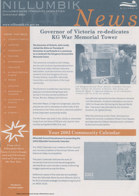
Journal - Newsletter, Nillumbik Shire Council, Nillumbik News, December 2000
... The newsletter highlights local council initiatives, community events, environmental programs, and infrastructure developments occurring across the Nillumbik Shire during late 2001. ...The newsletter highlights local council initiatives, community events, environmental programs, and infrastructure developments occurring across the Nillumbik Shire during late 2001. ...The newsletter highlights local council initiatives, community events, environmental programs, and infrastructure developments occurring across the Nillumbik Shire during late 2001. It focuses on community engagement, sustainability, local culture, and service improvements for residents. Christmas 2001 articles include: Governor of Victoria re-dedicates Kangaroo Ground War Memorial Tower [Shire of Eltham War Memorial] Election details (2002) Summer at the Diamond Creek Pool Community Safety Expo Nillumbik Festival of the Arts: ‘art, caught in the act’ 22 Feb to 3 Mar 2002 Neighbourhood Character Study out for comment Plans to revive St Andrews Market site Integrated Transport Strategy seeks less car usage Eltham Festival Album Rural connector roads strategy Rural Collector Roads to be Sealed Roundabout funding for Diamond Creek Community Fireguard helps prepare for fire Planning for bush fire this summer Capital Works projects on track for 2001-2002 Eltham Town Square opens council newsletters, nillumbik news, nillumbik shire council, alistair knox, andre haermeyer, andrea roberts, andy griffiths, barry dickens, brett wood, brooke ryan, david holmgren, deborah halpern, emma sam, erin monagle, jenny bourke, john butler, nick carson, robert doyle, sigmund jorgensen, tony fitzgerald, wendy evans, harry gilham, sally crew, matthew hall, diamond creek pool, edendale farm, peter perkins, norman golgerth, coco's lunch, sebastian jorgensen, judy jacques, invention in time, leslie avril, lola's delight, robbie grieg, chocolate lilies choir, st andrews market, neighbourhood character, eltham festival, frank lynch, eltham town square, ross mather, wendy mather, vince jones, rural road, plenty valley 88.6 fm, tony raunic, shire of eltham war memorial, jacinda brown -
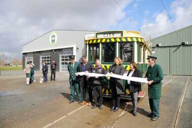
 Ballarat Tramway Museum
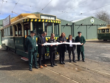
Photograph - Opening of the new track, Patricia Cameron, 10-9-2022
... Catherine King - Minister for Infrastructure, Transport, Regional Development and Local Government...Catherine King - Minister for Infrastructure, Transport, Regional Development and Local Government Provides information on the people involved at the time of the launch of the new replaced trackwork. ...Digital image by Patricia Cameron at the time of the launch or opening of the relaid or replaced track in Wendouree Parade and depot extension. Has Sam Boon, Cr Daniel Maloney, BTM President Paul Mong, Catherine King MP, Juliana Addison MP and Len Millar - standing in front of tram 13. Catherine King - Minister for Infrastructure, Transport, Regional Development and Local GovernmentProvides information on the people involved at the time of the launch of the new replaced trackwork.Digital Image of the cutting of the ribbon to open the new track - 10 September 2022 btm, trackwork, opening, launch, tram 13, museum, depot -
 Bendigo Historical Society Inc.
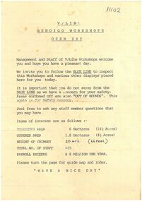
Ephemera - V/Line Bendigo workshops 'Open Day' leaflet
... The workshops were redeveloped in 2002 at a cost of $6.5 million - $4 million from VicTrack, $2 million from the State Government Regional Infrastructure Development Fund and $500,000 by the City of Greater Bendigo. ...The workshops were redeveloped in 2002 at a cost of $6.5 million - $4 million from VicTrack, $2 million from the State Government Regional Infrastructure Development Fund and $500,000 by the City of Greater Bendigo. ...The workshops were opened in November 1917 by the Victorian Railways. It opened in response to political pressures from provincial groups for decentralisation, with the Victorian Railways preferring the cheaper option of expanding the existing Newport Workshops in suburban Melbourne. Furthermore, unemployment had risen in both Bendigo and Ballarat due to a decline in mining operations. The main work carried out was repairs and maintenance of existing wagons and locomotives, however during 1919-22 thirteen new steam locomotives were also built - eight DD class (1033 - 1037, 1047 - 1049) and five A2 class (1078 - 1082). From the 1950s onwards, numerous steam locomotives were scrapped at the workshops. During the years immediately following nominal dieselisation in 1968, they were, at times, cutting up locomotives at the rate of one every two to three weeks. The workshops were also the site of the first VR brass foundry, which was transferred to Newport by the 1960s. Also, throughout 1965, VLX louvred vans were constructed at the workshops, at a rate of one a week. Other tasks included spring manufacture, construction of stainless steel footwarmers, and assembly of pantographs for electric trains, with a staff of 720 employed during 1966. By the 1980s, refurbishment work was also being carried out on Melbourne suburban electric multiple units. The 1980s were also a time of restructuring, and on the breakup of the Victorian Railways the workshops passed to the State Transport Authority and then the Public Transport Corporation. With privatisation the workshops were closed, with the loss of 262 jobs. In February 1996, the workshops were taken over by A Goninan & Co. In October 1999 the workshops were purchased by Great Northern Rail Services, with A Goninan & Co remaining as a tenant. In February 2001 A Goninan & Co vacated the site. The workshops were redeveloped in 2002 at a cost of $6.5 million - $4 million from VicTrack, $2 million from the State Government Regional Infrastructure Development Fund and $500,000 by the City of Greater Bendigo. The Bendigo Rail Workshops at North Bendigo are currently used by Southern Shorthaul Railroad to maintain broad gauge rolling stock for Pacific National, V/Line, Metro Trains Melbourne and CFCLA.Typed document. A4 page folded in half. On tan paper. Document pertaining to Bendigo V/Line workshops open day. Map on inside of folded page. Undated document.train, v/line, workshops, open day -
 Ballarat Tramway Museum
Photograph - Formal Opening of the new track, Benjamin Boehle-Mitchell, 10-9-2022
... Catherine King - Minister for Infrastructure, Transport, Regional Development and Local Government 2 - Listening to the speaches. 3 - Trams 13 and 33 at depot junction. 4 - Tram 13 at Carlton St 5 - Trams 13 and 33 at St Aidans Drive 6 - Another group photo - Daniel Maloney, Paul Mong, Catherine King, Peter Waugh and Juliania Addison....Catherine King - Minister for Infrastructure, Transport, Regional Development and Local Government 2 - Listening to the speaches. 3 - Trams 13 and 33 at depot junction. 4 - Tram 13 at Carlton St 5 - Trams 13 and 33 at St Aidans Drive 6 - Another group photo - Daniel Maloney, Paul Mong, Catherine King, Peter Waugh and Juliania Addison. ...Digital image by Benjamin Boehle-Mitchell at the time of the launch or opening of the relaid or replaced track in Wendouree Parade and depot extension. Image 1 - Has Sam Boon, Cr Daniel Maloney, BTM President Catherine King MP, Juliana Addison MP and Len Millar - standing in front of tram 13. Catherine King - Minister for Infrastructure, Transport, Regional Development and Local Government 2 - Listening to the speaches. 3 - Trams 13 and 33 at depot junction. 4 - Tram 13 at Carlton St 5 - Trams 13 and 33 at St Aidans Drive 6 - Another group photo - Daniel Maloney, Paul Mong, Catherine King, Peter Waugh and Juliania Addison.Provides information on the people involved at the time of the launch of the new replaced trackwork and the first public services.Set of six Digital Images of the cutting of the ribbon to open the new track and other associated images - 10 September 2022 btm, trackwork, opening, launch, tram 13, museum, depot, wednouree parade -
 Broadmeadows Historical Society & Museum
Photograph - Aerial Photograph
... development. The transformation accelerated in the 1990s and 2000s, with large-scale residential subdivisions, infrastructure projects, and commercial developments reshaping the landscape. ...development. The transformation accelerated in the 1990s and 2000s, with large-scale residential subdivisions, infrastructure projects, and commercial developments reshaping the landscape. ...Craigieburn is a rapidly growing suburb located approximately 25 km north of Melbourne’s CBD. Historically, it was a rural area with agricultural roots, but since the late 20th century, it has undergone significant urban development. The transformation accelerated in the 1990s and 2000s, with large-scale residential subdivisions, infrastructure projects, and commercial developments reshaping the landscape. Key historical milestones include: Early Settlement: Originally inhabited by the Wurundjeri people of the Kulin Nation. European Settlement: Began in the mid-1800s, primarily for farming and grazing. Urban Expansion: Post-1970s, Craigieburn saw increasing suburban development, especially after the extension of rail and road infrastructure. Recent Growth: From the 2000s onward, Craigieburn became one of Melbourne’s fastest-growing suburbs, with new estates, schools, and shopping centres.This large colour aerial photograph of Craigieburn holds significant value as a visual record of the suburb’s transformation from a semi-rural landscape to a dynamic urban centre in Melbourne’s northern growth corridor. Captured during a period of rapid development, the image documents the spatial evolution of Craigieburn, including residential expansion, infrastructure projects, and the integration of green spaces and commercial zones. The photograph is historically significant as it reflects the broader patterns of post-2000 suburban growth in Victoria, driven by population pressures, housing demand, and strategic planning initiatives. It provides insight into land use changes, transport connectivity (notably the Hume Highway and Craigieburn railway line), and the emergence of community hubs such as Craigieburn Central. From a cultural heritage perspective, the image contributes to understanding the lived environment of diverse communities who have settled in Craigieburn, including its role in accommodating Melbourne’s multicultural population. It also serves as a reference point for future urban planning, environmental monitoring, and historical comparison. The photograph is an important archival asset for researchers, planners, and local historians, offering a detailed snapshot of a pivotal moment in Craigieburn’s development trajectory.Colour aerial photograph of Craigieburnaerial photograph, craigieburn -
 Bendigo Historical Society Inc.
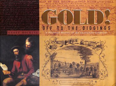
Book - "Gold! Off to the Diggings", 2010
... Economic Contributions: Gold mining became a cornerstone of the Australian economy, contributing to export income and the development of infrastructure. The wealth generated from gold mining helped finance the young colonies and led to the establishment of new towns and services....Economic Contributions: Gold mining became a cornerstone of the Australian economy, contributing to export income and the development of infrastructure. The wealth generated from gold mining helped finance the young colonies and led to the establishment of new towns and services. ...A pictorial history of the Australian goldrush. In 1851 Australia's gold rush had begun, and the focus of the world suddenly turned to the hills, gullies and creeks of New South Wales and Victoria as people from all over the world rushed to the diggings. Gold mining in Australia has a rich history that began in the early 19th century, leading to significant economic growth and population influx during the gold rushes of the 1850s. The first documented discovery of gold in Australia occurred in 1823 near Bathurst, New South Wales. However, it wasn't until 1851 that significant gold deposits were found at Ophir, which triggered the first major gold rush. The discovery of payable gold led to a massive influx of prospectors and miners from around the world, particularly during the Victorian Gold Rush. By the mid-1850s, Australia was producing nearly 40% of the world's gold. The gold rushes significantly increased Australia's population, with estimates suggesting that the population tripled from 1851 to 1860 due to the influx of miners and their families. Economic Contributions: Gold mining became a cornerstone of the Australian economy, contributing to export income and the development of infrastructure. The wealth generated from gold mining helped finance the young colonies and led to the establishment of new towns and services."Gold! Off to the Diggings" by Geoff Hocking. Published by New Chum Press in 2010. Hard cover book which is black fabric. Title and author's name in gold on spine. Dust jacket is multi-colored, with different gold mining scenes on front and back. Title written on gold and black on front cover and spine. Printed in Castlemaine, Australia. 320 pp. Glossy pages. Contains both text and black and white images. Has index. ISBN 9780957897236. gold, mining, miners -
 Sunshine and District Historical Society Incorporated
Photograph - Shire of Braybrook and City of Sunshine Town Clerks and Shire Secretaries Portraits
... Strategic and Long‑Term Planning Although less formalised than today, the Secretary played a key role in: - Planning infrastructure - Advising on township development - Managing land records and valuations - Coordinating with state government departments This mirrors the strategic functions now assigned to CEOs under the Local Government Act....Strategic and Long‑Term Planning Although less formalised than today, the Secretary played a key role in: - Planning infrastructure - Advising on township development - Managing land records and valuations - Coordinating with state government departments This mirrors the strategic functions now assigned to CEOs under the Local Government Act. ...This is a collection of photographs of former Shire / City secretaries and town clerks of the former Shire of Braybrook and City of Sunshine. Before modern CEOs existed in Victorian local government, the Shire / City Secretary or Clerk was the most senior administrative officer in a shire or city. They were effectively the chief executive, chief financial officer, and chief governance officer rolled into one. Below is a detailed breakdown of what a Shire / City Secretary traditionally did. 1. Chief Administrative Office The Shire Secretary managed the entire day‑to‑day operation of the shire, including: - Supervising all council staff - Implementing council decisions - Managing correspondence, records, and official documents - Ensuring services were delivered (roads, drainage, health, building, etc.) This is the historical equivalent of the CEO role described in modern council structures. 2. Governance and Council Support The Shire Secretary was responsible for: - Preparing agendas and minutes for council meetings - Advising councillors on legislation and procedures - Ensuring compliance with the Local Government Act - Managing elections and public notices This aligns with the governance responsibilities now embedded in the Local Government Act 2020. 3. Financial Management The Shire Secretary was also the shire’s chief financial officer: - Preparing budgets - Managing rates and revenue - Overseeing expenditure - Producing annual financial statements In many small shires, the Secretary also acted as Treasurer. 4. Public Interface The Shire Secretary was the main point of contact for the community: - Handling complaints and enquiries - Issuing permits and licences - Coordinating public works requests - Communicating council decisions to residents They were often the most recognisable council official in the district. 5. Strategic and Long‑Term Planning Although less formalised than today, the Secretary played a key role in: - Planning infrastructure - Advising on township development - Managing land records and valuations - Coordinating with state government departments This mirrors the strategic functions now assigned to CEOs under the Local Government Act.This collection of photographs shown all the men who served as the Shire Secretary, Town Clerk or CEO for the Shire of Braybrook or for the City of Sunshine.Sunshine Council July 2007 5452.01 - Shire of Braybrook Shire Secretary William 'Bill' Pullar 1860 - 1907.jpg 5452.02 - Shire of Braybrook Shire Secretary D. Lingford 1908 - 1911.jpg 5452.03 - Shire of Braybrook Shire Secretary Walter John Andrew 1911 - 1927.jpg 5452.04 - Shire of Braybrook Shire Town Clerk Edgar Hargreaves 1927 - 1954.jpg 5452.05 - City of Sunshine Town Clerk Thomas William 'Bill' Deutschmann 1954 - 1984.jpg 5452.06 - City of Sunshine Town Clerk G. S. Pearson 1984 - 1987.jpg 5452.07 - City of Sunshine CEO And Town Clerk J. James 1987 - 1992.jpg 5452.08 - City of Sunshine Town Clerk John Noble Willaton 1992 - 1994.jpg 5452.09 - Shire of Braybrook Shire Secretaries and Town Clerks 1860 - 1954.jpg 5452.10 - City of Sunshine Town Clerks 1954 - 1994.jpg shire of braybrook, city of sunshine, town clerk, shire secetary, william "bill" pullar, d. lingford, walter john andrew, edgar hargreaves, thomas william "bill" deutschmann, g. s. pearson, j. james, john noble willaton -
 Warrnambool and District Historical Society Inc.
Document - Ledger: Warrnambool Shire Letter book 1861-1865, Circa 1860
... infrastructure in the period of the 1860’s. The period contained within this ledger is very early in the establishment of the district. It shows the co-operation and initiative between councils, government departments and individuals in matters relating drainage, bridges , roads all vital to the development of the region. warrnambool warrnambool shire tenders district roads board a davies 1861-1865 : On the spine is a paper label, “January1861-April 1865.Label inside front cover “Sands &Kenny. ...Contains correspondence pertaining to matters of infrastructure in the period of the 1860’s. The period contained within this ledger is very early in the establishment of the district. It shows the co-operation and initiative between councils, government departments and individuals in matters relating drainage, bridges , roads all vital to the development of the region.Fawn cloth on card cover with tan corner and spine binding. Contains alphabetical index at the front. Letters are written on very fine paper.: On the spine is a paper label, “January1861-April 1865.Label inside front cover “Sands &Kenny. Account Book Manufacturers, Stationers &Printers, Collins St Melbourne. The index contains the following names :W G Allan, Bostock, Biggs, Bench of Magistrates Caramut, Niel Black, Commissioner of the Crown Lands Warrnambool, Commissioner of Roads and Bridges, Cross, Carr, Duffy, Davies, Duffus, Fitzmaurice, Horace Flower warrnambool, warrnambool shire, tenders, district roads board, a davies, 1861-1865 -
 Warrnambool and District Historical Society Inc.
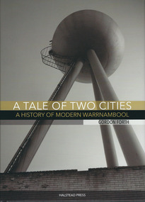
Book, Gordon Forth, A tale of two cities: a History of Modern Warrnambool, 2015
... infrastructure, employment, industry, health, education and politics. The author, Gordon Forth, was formerly a lecturer in the Faculties of Education and Arts and the Director of the Centre for Regional Development at Deakin University in Warrnambool. ...infrastructure, employment, industry, health, education and politics. The author, Gordon Forth, was formerly a lecturer in the Faculties of Education and Arts and the Director of the Centre for Regional Development at Deakin University in Warrnambool. ...The story of modern Warrnambool covering the period of the 1980's to 2015.This is a hardcover book of 320 pages. The dust cover is multi-coloured (black, white and gold) with an image of the water tower at the former Fletcher Jones Factory site on the front cover and an image of the Warrnambool Breakwater on the back cover. The hard cover book has the same colouring and images as the dust cover.non-fictionThe story of modern Warrnambool covering the period of the 1980's to 2015.warrnambool, gordon forth, a history of modern warrnambool, a tale of two cities -
 Kiewa Valley Historical Society
Photograph - Mt Beauty timber Industries, 1960's (estimate only)
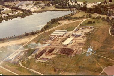
... infrastructure for an increasing population of workers for the hydro-electric scheme as there was a general shortage of this commodity. A timber mill was started in Tawonga by Mates, of Albury, in 1945, and electricity became available in 1946 the S.E.C. bought the mill, and enlarged it. In 1960 it was purchase by a local family. They also started a timber mill in Mt Beauty and worked both until 1980 when they closed the Tawonga mill and enlarged the mill called Mt. Beauty Timbers Pty Ltd which employed approximately 50 people. A pictorial record of the development ...Hume and Hovell discovered the area in 1824 and by the end of the 19th century the valley was transformed by logging, dairy and beef cattle properties and tobacco farms. Timber was required for construction of McKay Creek Power Station which began construction in 1951 and also the camps and houses for the workers and their families. There was a need for housing and infrastructure for an increasing population of workers for the hydro-electric scheme as there was a general shortage of this commodity. A timber mill was started in Tawonga by Mates, of Albury, in 1945, and electricity became available in 1946 the S.E.C. bought the mill, and enlarged it. In 1960 it was purchase by a local family. They also started a timber mill in Mt Beauty and worked both until 1980 when they closed the Tawonga mill and enlarged the mill called Mt. Beauty Timbers Pty Ltd which employed approximately 50 people. A pictorial record of the development of the Mt Beauty community and the local timber industry.Colour photograph of aerial view of Mt Beauty Timber Mills and surrounding area including pondage and part of airfield. Photo taken in 1960’s (estimate only)Handwritten in ink on back of photograph in very faint writing – Recent photo of Mt Beauty Timber Industries Mt Beauty Operationsmt beauty timber industry, timber industry, timber mill, secv -
 Kiewa Valley Historical Society
Photograph - Mount Beauty Timber Industries, 1960's (estimate only)
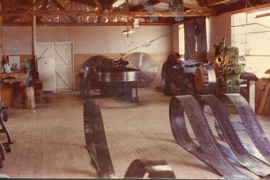
... infrastructure for an increasing population of workers for the hydro-electric scheme as there was a general shortage of this commodity. A timber mill was started in Tawonga by Mates, of Albury, in 1945, and electricity became available in 1946 the S.E.C. bought the mill, and enlarged it. In 1960 it was purchase by a local family. They also started a timber mill in Mt Beauty and worked both until 1980 when they closed the Tawonga mill and enlarged the mill called Mt. Beauty Timbers Pty Ltd which employed approximately 50 people. A pictorial record of the development ...Hume and Hovell discovered the area in 1824 and by the end of the 19th century the valley was transformed by logging, dairy and beef cattle properties and tobacco farms. Timber was required for construction of McKay Creek Power Station which began construction in 1951 and also the camps and houses for the workers and their families. There was a need for housing and infrastructure for an increasing population of workers for the hydro-electric scheme as there was a general shortage of this commodity. A timber mill was started in Tawonga by Mates, of Albury, in 1945, and electricity became available in 1946 the S.E.C. bought the mill, and enlarged it. In 1960 it was purchase by a local family. They also started a timber mill in Mt Beauty and worked both until 1980 when they closed the Tawonga mill and enlarged the mill called Mt. Beauty Timbers Pty Ltd which employed approximately 50 people. A pictorial record of the development of the local timber industry in the Kiewa Valley showing equipment used in timber milling.Colour photograph of Mt Beauty Timber Industries Mill. Photo taken inside the workshop showing saw blades and equipmentmt beauty, mt beauty timber industry, timber mill -
 Kiewa Valley Historical Society
Set of 2 hand coloured photographs of early Mount Beauty, photographs of Mount Beauty, 1947/48
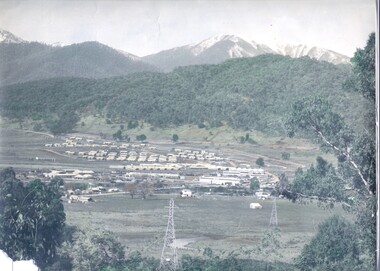
... development of a town from grazing land. The type of terrain that had to be surveyed and then to construct roads and other infrastructure, with very little machinery, is also of prime significance in the development of the Kiewa Hydro Electric Scheme. mount beauty, housing, accommodation Photo No.1 - on back of photo, left upper corner, faintly in pencil, SPIKE, underneath this is written T Pay,. ...Construction of the town of Mount Beauty commenced in 1946 and continued until 1952. It was built to provide family accommodation for workers engaged in the construction of the hydro electric power scheme. As well as housing, there was an administration building, staff hostel, merchandising centre, workmen's camps, base stores and workshops and the Mount Beauty Terminal Station. The first house was occupied in November, 1946 by the then manager of the trading store, with a frontage onto Hollonds Street. The total number of houses erected was 488, 162 custom built and 326 prefabricated. The main workmen's camp can be seen just left of the centre of the photograph and accommodated 144 men at the time of the photograph. By 1950 it could accommodate 1200men. Photo No. 1 is taken in 1947/early 1948 as there is no evidence of the staff hostel under construction. This hostel was commenced in August/September 1948 and is clearly shown in photograph No. 2, dating this photo as 1948 as it is before the completion of the bypass road connecting to the main (high plains) road. This road was constructed in 1939 and in 1948 followed the route of Tawonga Crescent. This remained in use until the bypass construction was completed in early 1949 and does not appear to be finished in this photograph.. Both photographs are taken from the power line easement adjacent to the Bright road.Significant historical pictorial record of the development of a town from grazing land. The type of terrain that had to be surveyed and then to construct roads and other infrastructure, with very little machinery, is also of prime significance in the development of the Kiewa Hydro Electric Scheme.Two photographs, both hand painted to show colours, and both of Mount Beauty c 1947/48 not long after commencement of construction of homes and facilities for workers.Photo No.1 - on back of photo, left upper corner, faintly in pencil, SPIKE, underneath this is written T Pay,. Photo No. 2 - on back of photo, left upper corner, faintly in pencil, Jmount beauty, housing, accommodation -
 Kiewa Valley Historical Society
Map - Kiewa Scheme General Plan
... Mountains, rivers, roads and SECV places are named, also SECV infrastructure and construction eg. workers camps, Power stations. Significant for the information re the Kiewa Hydro Electric Scheme's development. bob duncan kiewa hydro electric scheme secv khes development Handwritten: 'Bob Duncan' Yellowed paper with brown print. ...Existing and possible future roads are numbered and named 1 - 45. The plan is based on an aerial photos taken March 1945. It includes revisions up to 1951. Signed by H.H.C. Williams, construction engineer. Mountains, rivers, roads and SECV places are named, also SECV infrastructure and construction eg. workers camps, Power stations.Significant for the information re the Kiewa Hydro Electric Scheme's development.Yellowed paper with brown print. Kiewa Scheme general plan showing its development. A lot of information is recorded. Note: Dyeline print was used which causes fading when exposed to light. Handwritten: 'Bob Duncan'bob duncan, kiewa hydro electric scheme, secv, khes development -
 Kiewa Valley Historical Society
Photograph Transmission lines Mount Beauty, 66 KVA Transmission lines from Clover Power Station, Circa 1950
... infrastructure). This photograph shows the beginning of the accommodation and administration buildings for use by the construction workers and auxiliary administration employees of the Victorian State Electricity Commission. It also provides a view of the landscape before extensive development...infrastructure). This photograph shows the beginning of the accommodation and administration buildings for use by the construction workers and auxiliary administration employees of the Victorian State Electricity Commission. It also provides a view of the landscape before extensive development ...This photograph is a "snap shot" in time circa 1950s detailing the rural environmental change and the progressive effects of the Kiewa Valley Hydro Scheme on the basic rural setting of the valley (note the sparsity of rural infrastructure). This photograph shows the beginning of the accommodation and administration buildings for use by the construction workers and auxiliary administration employees of the Victorian State Electricity Commission. It also provides a view of the landscape before extensive development of Pondage and other non rural buildings.This photograph details a dramatic period in time which saw an enormous change to the exclusively rural area of the Kiewa Valley region in the mid 1900s (see sparse rural buildings/houses). This change presented both physical and mental challenges to the existing quiet rural inhabitants of the valley. The State of Victoria had to make adjustments to the changing demands imposed by population and industrial expansions. The development of cleaner energy supplies to a growing population has its downside ,which ever way the intrusion into the "natural" landscape is made. The construction of the large Pondage at the centre of the photograph is a good example.This black and white photograph of a panoramic view of the Kiewa Valley (Mount Beauty SEC construction workers village) shows the newly completed transmission line towers delivering electrical power(66KVA) from the Clover Power Station. The photo is on 200gms paper and not on special photographic paper.mount beauty 1940 to 1950s, development of sec kiewa hydro scheme, sec victoria -
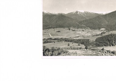
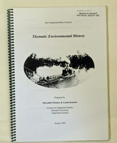 Orbost & District Historical Society
book, Thematic Environmental History, 2001
... development have influenced the culture of the area and the natural and built environment. The document is not a social history but usually provides the context for future heritage studies and assessments and would provide input to the preparation of a Heritage Action Plan. This booklet prepared for the East Gippsland Shire council environmental-study-East-Gippsland Copywright held by East Gippsland Shire Council and Department of Infrastructure ...This booklet was prepared for the East Gippsland Shire Council in August 2001.A Thematic Environmental History identifies how key patterns of development have influenced the culture of the area and the natural and built environment. The document is not a social history but usually provides the context for future heritage studies and assessments and would provide input to the preparation of a Heritage Action Plan. This booklet prepared for the East Gippsland Shire councilA spiral bound book of 75 pp, titled Thematic Environmental History, prepared by Meredith Fletcher and Linda Kennett for the Centre for Gippsland Studies, Monash University, Gippsland Campus. On the front cover is a black and white drawing of a paddle steamer towing a barge along a river. It contains information on the discovery, settlement and land usage of East Gippsland as well as the development of transport, communication and cultural institutions. Copywright held by East Gippsland Shire Council and Department of Infrastructureenvironmental-study-east-gippsland -
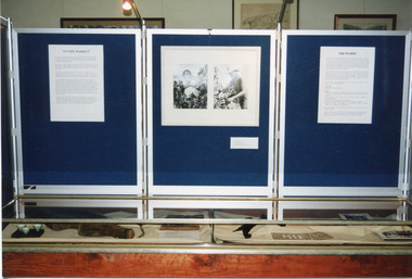 The Beechworth Burke Museum
Photograph, 1999
... development, specifically of orchards, in the area. The expansion of vineyards and horticulture in the Beechworth district followed gold rush prosperity in the mid-1850s, with nearly ninety acres of gardens and small farms under vineyards by 1865. There were 400 Chinese market gardeners and hawkers in the area in 1868. The growth of agriculture in the Ovens district in the mid -1860s led to advocacy by local farmers for the extension of railway infrastructure ...This photograph features three display board sections showing information and photographs from 'The Harvest' exhibition inside the Burke Museum at Beechworth in 1999. The boards are titled 'To the Market' and 'Orchards'; the accompanying text cannot be read. The two accompanying photographs depict a man and woman picking fruit.This photograph is of social significance to Burke Museum and the Beechworth community, documenting an exhibition, The Harvest, held in 1999 to communicate the importance of agricultural development, specifically of orchards, in the area. The expansion of vineyards and horticulture in the Beechworth district followed gold rush prosperity in the mid-1850s, with nearly ninety acres of gardens and small farms under vineyards by 1865. There were 400 Chinese market gardeners and hawkers in the area in 1868. The growth of agriculture in the Ovens district in the mid -1860s led to advocacy by local farmers for the extension of railway infrastructure from Melbourne to improve access to distant markets.Colour rectangular photograph printed on matte AGFA photographic paper.Obverse: TO THE MARKET / ORCHARDS/ Reverse: 2856beechworth, burke museum, promoting settlement, living in country towns, making regional centres, preserving traditions and commemorating, farming and agriculture, orchards, exhibitions, burke museum exhibitions, fruitpicking, building local economies, transforming land, victorian agricultural history, marketing and promoting agricultural products, growing fruit and vegetables, the harvest exhibition, harvests, vineyards, victorian gold rush towns -
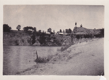 The Beechworth Burke Museum
Photograph
... infrastructure and facilities to meet the present needs of their population. Beechworth Beechworth Lake Lake Sambell L.H. Sambell McConvill Rocky Mountain Mining Company Rocky Mountain Mining Co Minister of Lands Forward Beechworth Committee Wallace Park-Lake Sambell Development Scheme Wallace Park Lake Sambell Development Scheme Lake Sambell J. ...The photograph depicts two young men standing atop a prominent outcrop at Lake Sambell, with buildings visible on the further shore. The present day park and reserve occupies the site of the former Rocky Mountain Mining Company, an open-cut sluice mine that began operations in the mid-Nineteenth Century and operated until the early 1900s, through the peak of Victoria’s Gold Rush. It was converted into a park and leisure area in the 1920s. Lake Sambell was formally opened to the public on Friday 5th October 1928 and was opened by the Victorian Government’s Minister of Lands, Mr Bailey, as part of initiatives to boost the economies and development of country towns. The lake was named after Mr L.H. Sambell, a shire engineer and secretary of the Forward Beechworth Committee who was involved in promoting the transformation of the mining site and promoting plantation forestry and tourism as alternative industries. £300 to begin the process was provided by Mr J. McConvill, a former resident of Beechworth, who is remembered in a street name adjacent to the lake. An article in the Ovens and Murray Advertiser on Saturday, 5th May, 1917, gives some insight into issues in the Rocky Mountain Mining Company’s final years. The writer details the 1917 annual meeting of the Rocky Mountain Mining Company, stating that locals present appeared ‘well pleased this important local industry is in such a prosperous condition and that future prospects are so encouraging’. The author describes plans to give workers a bonus as evidence of profit-sharing that would ‘bridge the gulf between capital and labour’. The article concludes, however, with the statement that ‘there is a little arithmetical puzzle in the report in connection with the dredging operations I have been unable to solve.' The photograph is significant as it contributes to knowledge about how Beechworth reinvented itself after the Gold rush period, and more broadly how country towns repurpose and redevelop infrastructure and facilities to meet the present needs of their population. Sepia rectangular photograph printed on matte photographic paper. Obverse: nil. Reverse: 3471 / Velox (paper mark)beechworth, beechworth lake, lake sambell, l.h. sambell, mcconvill, rocky mountain mining company, rocky mountain mining co, minister of lands, forward beechworth committee, wallace park-lake sambell development scheme, wallace park lake sambell development scheme, lake, sambell, j. mcconvill, recreation, reserve, park, transformation, repurposed, redeveloped -
 The Beechworth Burke Museum
Photograph - Lantern Slide, c1900
... development of modern photography and film-making techniques. This glass slide is significant because it provides insight into Beechworth's social amenities and religious infrastructure in the late Nineteenth Century. ...Beechworth's Anglican Church, Christ Church St Peter and St Paul, has served the Beechworth community since 1858 in its present form, following its beginnings in a tent in 1855. The Victorian branch of the National Trust classified the building as regionally significant in 1959 and the organ as of significance to the nation in 1992. Building a place for Anglican worship was a priority in the early days of Beechworth's settlement as the town was a site of regional administration due to its association with the economic and social expansion of Victoria during the Gold Rush period. The Church garden features several significant trees monitored by the Beechworth Treescape Group, including a cork oak growing near the Ford Street entrance, an Atlantic cedar, a bunya or bunya-bunya pine and two kurrajongs. Some of these long-established trees may be visible in this lantern-slide image. Lantern slides, sometimes called 'magic lantern' slides, are glass plates on which an image has been secured for the purpose of projection. Glass slides were etched or hand-painted for this purpose from the Eighteenth Century but the process became more popular and accessible to the public with the development of photographic-emulsion slides used with a 'Magic Lantern' device in the mid-Nineteenth Century. Photographic lantern slides comprise a double-negative emulsion layer (forming a positive image) between thin glass plates that are bound together. A number of processes existed to form and bind the emulsion layer to the base plate, including the albumen, wet plate collodion, gelatine dry plate and woodburytype techniques. Lantern slides and magic lantern technologies are seen as foundational precursors to the development of modern photography and film-making techniques.This glass slide is significant because it provides insight into Beechworth's social amenities and religious infrastructure in the late Nineteenth Century. It is also an example of an early photographic and film-making technology in use in regional Victoria in the time period.Thin translucent sheet of glass with a square image printed on the front and framed in a black backing. It is held together by metals strips to secure the edges of the slide.Obverse: 1 /beechworth, lantern slide, slide, glass slide, plate, burke museum collection, photograph, monochrome, christ church, indigo shire, north-east victoria, churches, architecture, anglican, religion, atlantic cedar, organ, magic lantern, christ church st peter and st paul, beechworth treescape group, cork oak, bunya pine, bunya bunya, kurrajong, quercus suber, cedrus atlantica f. glauca, araucaria bidwillii, brachychiton populneus -
 The Beechworth Burke Museum
Photograph - Lantern Slide, c1900
... infrastructure such as heating and water supplies, leading to high turnover of nurses and other issues. A program of building works to extend and improve facilities followed over subsequent decades. Lantern slides, sometimes called 'magic lantern' slides, are glass plates on which an image has been secured for the purpose of projection. Glass slides were etched or hand-painted for this purpose from the Eighteenth Century but the process became more popular and accessible to the public with the development...infrastructure such as heating and water supplies, leading to high turnover of nurses and other issues. A program of building works to extend and improve facilities followed over subsequent decades. Lantern slides, sometimes called 'magic lantern' slides, are glass plates on which an image has been secured for the purpose of projection. Glass slides were etched or hand-painted for this purpose from the Eighteenth Century but the process became more popular and accessible to the public with the development ...This image appears to show nurses at what is now the Mayday Hills Mental Asylum arriving for work in approximately 1900. These individuals are part of a long history of nursing in Beechworth. Three medical or social welfare facilities opened in the mid-1800s as part of a push by the township to become a regional centre for Government services. These were the Ovens District Hospital (opened in 1857), the Ovens Benevolent Asylum (opened in 1863), and the Beechworth Mental Hospital (opened in 1867 and renamed Mayday Hills Hospital at Centenary celebrations in 1967). It was recognised that the unsettled living conditions, poverty and relative isolation of the Goldfields environment could produce 'mental disturbances' which required local treatment facilities as services in Melbourne were too far away. Carole Woods' publication 'A Titan's Field' describes activities undertaken by patients at Beechworth Mental Hospital as including monthly balls and occasional concerts as well as work to make the facility self-supporting such as farm work and making clothes. She mentions a report in 1870 that the approximately 300 patients were clean and neat with 'no-one in restraint or seclusion' but that by 1905 the organisation had 623 patients which placed strain on building infrastructure such as heating and water supplies, leading to high turnover of nurses and other issues. A program of building works to extend and improve facilities followed over subsequent decades. Lantern slides, sometimes called 'magic lantern' slides, are glass plates on which an image has been secured for the purpose of projection. Glass slides were etched or hand-painted for this purpose from the Eighteenth Century but the process became more popular and accessible to the public with the development of photographic-emulsion slides used with a 'Magic Lantern' device in the mid-Nineteenth Century. Photographic lantern slides comprise a double-negative emulsion layer (forming a positive image) between thin glass plates that are bound together. A number of processes existed to form and bind the emulsion layer to the base plate, including the albumen, wet plate collodion, gelatine dry plate and Woodburytype techniques. Lantern slides and magic lantern technologies are seen as foundational precursors to the development of modern photography and film-making techniques This glass slide is significant because it provides insight into Beechworth's social and medical amenities in the early Twentieth Century, around the time of Australia's Federation into one nation. It is also an example of an early photographic and film-making technology in use in regional Victoria in the time period.Thin translucent sheet of glass with a rectangular image printed on the front and framed in a black backing. It is held together by metals strips to secure the edges of the slide.Obverse: i /burke museum, beechworth, lantern slide, slide, glass slide, plate, burke museum collection, photograph, monochrome, magic lantern, indigo shire, north-east victoria, nineteenth century, 1900s, twentieth century, emulsion slides, nursing, nurses, mental hospitals, lunatic asylums, asylums, social services, social welfare, insane asylums, mental health, infrastructure -
 The Beechworth Burke Museum
Photograph - Lantern Slide, c1900
... development of modern photography and film-making techniques. This glass slide is significant because it provides insight into Beechworth's built environment and commercial and official infrastructure in the early Twentieth Century, around the time of Australia's Federation into one nation. ...This image shows a semi-aerial view of commercial and official properties lining Ford Street, Beechworth, in approximately 1900. The tower of Christ Church of St Peter and St Paul can be seen in the middle section of the photograph, on the left-hand side of the street. The Church was constructed in 1858 with the tower added to the structure in 1864. Lantern slides, sometimes called 'magic lantern' slides, are glass plates on which an image has been secured for the purpose of projection. Glass slides were etched or hand-painted for this purpose from the Eighteenth Century but the process became more popular and accessible to the public with the development of photographic-emulsion slides used with a 'Magic Lantern' device in the mid-Nineteenth Century. Photographic lantern slides comprise a double-negative emulsion layer (forming a positive image) between thin glass plates that are bound together. A number of processes existed to form and bind the emulsion layer to the base plate, including the albumen, wet plate collodion, gelatine dry plate and woodburytype techniques. Lantern slides and magic lantern technologies are seen as foundational precursors to the development of modern photography and film-making techniques.This glass slide is significant because it provides insight into Beechworth's built environment and commercial and official infrastructure in the early Twentieth Century, around the time of Australia's Federation into one nation. It is also an example of an early photographic and film-making technology in use in regional Victoria in the time period.Thin translucent sheet of glass with a square image printed on the front and framed in a black backing. It is held together by metals strips to secure the edges of the slide.burke museum, beechworth, lantern slide, slide, glass slide, plate, burke museum collection, photograph, monochrome, ford street, christ church of st peter and st paul, church tower, landmarks, 1900, shopping facilities, public buildings, 1900s, built environment, streetscape