Showing 66 items matching "instrument used for navigation"
-
 Flagstaff Hill Maritime Museum and Village
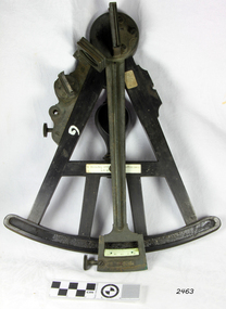
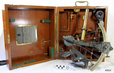
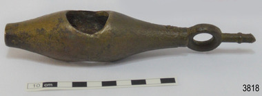
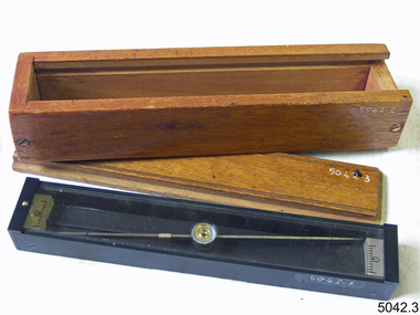
Octant, Late 18th to mid-19th century
... ...instrument used for navigation...An Octant is a doubly reflecting navigation instrument used primarily by sailors to measure the angular distance between two visible objects and was a forerunner of the sextant. ...It also demonstrates the skill and workmanship of the early instrument makers that operated from London at this time and provided most of the navigational instrumentation use by commercial and military navies of the time. flagstaff hill warrnambool shipwrecked-coast flagstaff-hill flagstaff-hill-maritime-museum maritime-museum shipwreck-coast flagstaff-hill-maritime-village navigation navigational instrument instrument used for navigation sextant henry hemsley instrument maker london octant "H. ...An Octant is a doubly reflecting navigation instrument used primarily by sailors to measure the angular distance between two visible objects and was a forerunner of the sextant. The name comes from the Latin octo, or “one-eighth of a circle,” for the Octant’s arc which spans 45°, or one-eighth of a circle. The primary use of an Octant is to measure the angle between an astronomical object and the horizon for the purposes of celestial navigation. The estimation of this angle is known as sighting or shooting the object, or taking a sight. The angle, and the time when it was measured, can be used to calculate a position line on a nautical chart (latitude), for example, sighting the Sun at noon or Polaris at night (in the Northern Hemisphere) gives an angle by which the latitude can then be estimated. Sighting the height of a landmark on land can also give a measure of distance. History: The principle of the Octant as an instrument to measure ones latitude was first implemented around 1742-present but was superseded by the improvement of the octant to a sextant, a very similar instrument, better made and able to measure bigger angles 120°, allowing the measurement of Luna distances to give longitude when used with an accurate chronometer. The sextant started to appear around 1730 and had been attributed to by John Hadley (1682–1744) and Thomas Godfrey (1704–1749), but reference to the sextant was also found later in the unpublished writings of Isaac Newton (1643–1727). Earlier links can be found to Bartholomew Gosnold (1571–1607) indicating that the use of a Sextant for nautical navigation predates Hadley's implementation. In 1922, the sextant was modified for aeronautical navigation by Portuguese navigator and naval officer Gago Coutinho. Henry Hemsley was a lesser-known instrument maker and optician working in London in the late 17th and early 18th century. However, it should be noted that there were two Henry Hemsley opticians and instrument makers around this period. (Henry Hemsley 1, 1786-89, who had premises at 85 Fleet St London and Henry Hemsley 2, 1828-56), whose workshop was at 135-138 Radcliff Highway London. Therefore, based on the inscribed workshop address Henry Hemsley 2 is responsible for making this example.The octant is representative of its type and although not fully complete it demonstrates how 18th and 19th-century mariners determined their latitude on a chart to navigate their way across the world's oceans in the 18th and 19th century. It also demonstrates the skill and workmanship of the early instrument makers that operated from London at this time and provided most of the navigational instrumentation use by commercial and military navies of the time.Octant, ebony wooden frame and handle. Scale is missing from recess in frame. "H. Hemsley 135-138 Ratliff Highway, London", no box"H. Hemsley 135-138 Ratcliff Highway, London"flagstaff hill, warrnambool, shipwrecked-coast, flagstaff-hill, flagstaff-hill-maritime-museum, maritime-museum, shipwreck-coast, flagstaff-hill-maritime-village, navigation, navigational instrument, instrument used for navigation, sextant, henry hemsley, instrument maker, london, octant -
 City of Moorabbin Historical Society (Operating the Box Cottage Museum)
Tools, Compass, 20thC
... A compass is an instrument used for navigation and orientation that shows direction relative to the geographic cardinal directions, or "points"....City of Moorabbin Historical Society (Operating the Box Cottage Museum) Joyce Park Jasper Road Ormond melbourne A compass is an instrument used for navigation and orientation that shows direction relative to the geographic cardinal directions, or "points". ...A compass is an instrument used for navigation and orientation that shows direction relative to the geographic cardinal directions, or "points". -
 8th/13th Victorian Mounted Rifles Regimental Collection
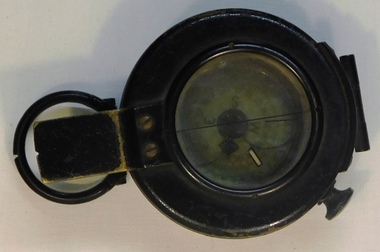
Prismatic Compass
... Military type prismatic compass with hinged lid and rotating glass face with luminus markings allowing the instrument to be used for night navigation. Black metal construction....8th/13th Victorian Mounted Rifles Regimental Collection 4/19 Prince of Wales's Light Horse Simpson Barracks McLeod melbourne Representative of a piece of military equipment used in both world wars. compass military Military type prismatic compass with hinged lid and rotating glass face with luminus markings allowing the instrument to be used for night navigation. ...Representative of a piece of military equipment used in both world wars.Military type prismatic compass with hinged lid and rotating glass face with luminus markings allowing the instrument to be used for night navigation. Black metal construction.compass, military -
 Bendigo Military Museum
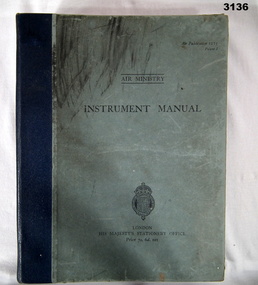
Manual - AIR MINISTRY INSTRUMENT MANUAL, British Air Ministry et al, 1937
... Many pages. 11 sections on flight instruments & their use. Illustrated drawings, photos & navigational charts....Many pages. 11 sections on flight instruments & their use. Illustrated drawings, photos & navigational charts. ...Light blue hard cover book with Royal Coat of Arms at bottom, blue buckram binding & black print. Many pages. 11 sections on flight instruments & their use. Illustrated drawings, photos & navigational charts.Inside front cover: “A M Watkins 10”books - manuals/military/air force, british, instrument -
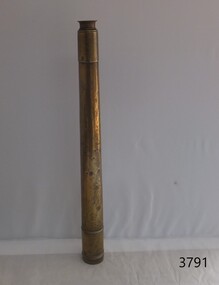
 Flagstaff Hill Maritime Museum and Village
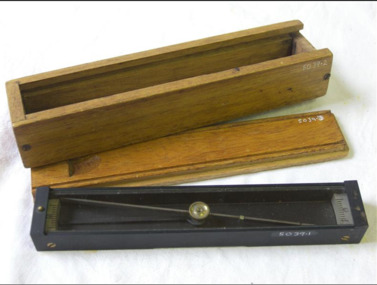
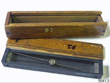
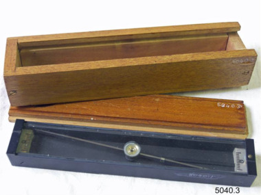
Instrument - Navigational Sextant, 1882-1890
... instrument but better made and allows larger angles from 60° to 120°. This improvement allows distances to be accurately calculated thereby giving longitude when used with a chronometer. The sextant was derived from the octant in 1757, eventually making all previous instruments used for navigational positioning obsolete. ...Box contains many parts for the sextants use. Instrument Navigational Sextant Heath & Co Heath & Co ...A sextant is an astronomical instrument used to determine latitude and longitude at sea by measuring angular distances, especially the altitudes of the sun, moon, and stars. It is a doubly reflecting navigation instrument and used mainly by sailors to measure the angular distance between two visible objects. The name comes from the Latin sextans, or “sixth part of a unit,” because the sextant’s arc can be 60° or 120° of a circle depending on the model used. The primary use was to measure the angle between an astronomical object and the horizon for the purposes of celestial navigation. The estimation of this angle is known as sighting or shooting the object, or taking a sight. This angle and the time when it was measured is used in order to determine Greenwich Mean Time and hence longitude. Sighting the height of a landmark on land can also give a measure of distance from that object. History: The development of the sextant was as an improvement over the octant, an instrument designed to measure one's latitude. The octant was first implemented around 1731-present but can only measure angles up to 45°. As larger angles were needed to allow the measurement of lunar objects - moon, stars and the sun - at higher angles, the octant was superseded by the sextant. The sextant is a similar instrument but better made and allows larger angles from 60° to 120°. This improvement allows distances to be accurately calculated thereby giving longitude when used with a chronometer. The sextant was derived from the octant in 1757, eventually making all previous instruments used for navigational positioning obsolete. The sextant had been attributed to by John Hadley (1682–1744) and Thomas Godfrey (1704–1749), but reference to the sextant was also found later in the unpublished writings of Isaac Newton (1643–1727). Earlier links can be found to Bartholomew Gosnold (1571–1607) indicating that the use of a sextant for nautical navigation predates Hadley's implementation. In 1922, the sextant was modified for aeronautical navigation by Portuguese navigator and naval officer Gago Coutinho. It should be noted that the octant and quadrant are in the same family as they were, and all are, regarded as sextants. The sextant is representative of it's type and although not fully complete it demonstrates how 18th,19th and 20th century mariners determined their latitude and longitudinal to determine their position on a chart, allowing them to navigate there way across the world's oceans. It also demonstrates the skill and workmanship of the early instrument makers that operated scientific instrument businesses from London and other areas of England to provide most of the navigational instrumentation used by commercial and military navies of the time.Sextant with square, fitted box of polished wood, "Hezzanith" brand. Box contains many parts for the sextants use. On certificate "Heath & Co, London. Sextant Number Y 822". Catch on lid "DEFIANT LEVER" and "PATENT NUMBER 187.10". Maker's certificate is attached to the inside of the box.flagstaff hill, warrnambool, shipwrecked-coast, flagstaff-hill, flagstaff-hill-maritime-museum, maritime-museum, shipwreck-coast, flagstaff-hill-maritime-village, sextant box, sextant, hezzanith, heath & co, navigational instrument, george wilson heath, astronomical instrument, instrument manufacturers, scientific instrument, navigation, celestial navigation, octant, quadrant, lunar navigation -
 Bendigo Military Museum
Equipment - FLYING INSTRUMENTS, AIR NAVIGATION
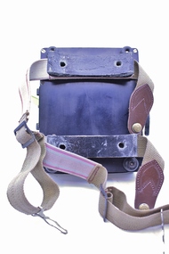
... instruments used by Flight Lieutenant Ian A. Lyons. Part of the Flight Lieutenant Ian A. 'Joe' Lyons MBE Collection. See Catalogue No. 5374P for his service record. equipment flying instruments air navigation Flight Lieutenant Ian A. ...Flying instruments used by Flight Lieutenant Ian A. Lyons. Part of the Flight Lieutenant Ian A. 'Joe' Lyons MBE Collection. See Catalogue No. 5374P for his service record.Rectangular padded and sectioned wooden box containing seventeen brass, stainless steel and plastic air navigation instruments. The box is covered in black leatherette and hinged with small brass hinges. A silver coloured clasp secures the box closed. A metal plate is pinned to the middle of the lid.equipment, flying instruments, air navigation, flight lieutenant ian a. lyons -
 Nhill Aviation Heritage Centre
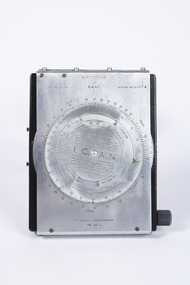
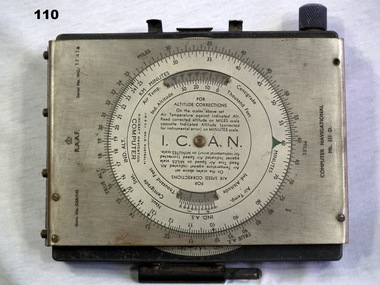
Navigation Computer
... Nhill Aviation Heritage Centre 1 Aerodrome Road Nhill grampians This type of instrument typically used by pilots and navigators for quick calculations of Air Speed and Wind Drift. Indent No. G6B/145 RAAF Serial No. WG/2967* I.C.A.N. in center of front dial COMPUTER NAVIGATIONAL Ml. ...This type of instrument typically used by pilots and navigators for quick calculations of Air Speed and Wind Drift.hand operated navigation computer. Rotating scale on the front panel and a scroll type scale on the inner panel with a winder knob on the right side. Front panel is hinged at the top and bottom has two curved thigh pads.Indent No. G6B/145 RAAF Serial No. WG/2967* I.C.A.N. in center of front dial COMPUTER NAVIGATIONAL Ml. III D. -
 Nhill Aviation Heritage Centre
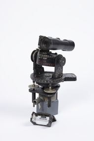
Instrument - Astro Compass Mk.II, c1940
... This instrument was one of the type used for training night navigation at the Nhill Air School...Nhill Aviation Heritage Centre 1 Aerodrome Road Nhill grampians This instrument was one of the type used for training night navigation at the Nhill Air School astro compass compass instrument navigation cramer AM Astro Compass Mk.II, REF 6A/1174, 4C Black metal instrument with pivot points and white markings to 360 degrees. ...This instrument was one of the type used for training night navigation at the Nhill Air SchoolBlack metal instrument with pivot points and white markings to 360 degrees. Telescope sighting piece and bubble level gauges and screw adjusters. Includes separate sight original fitting.AM Astro Compass Mk.II, REF 6A/1174, 4C astro compass, compass, instrument, navigation, cramer -
 Nhill Aviation Heritage Centre
Instrument - Astro Compass
... This instrument is the type used in the Nhill Air School navigation training...Nhill Aviation Heritage Centre 1 Aerodrome Road Nhill grampians This instrument is the type used in the Nhill Air School navigation training astro compass navigation instrument AM, Astro Compass Mk.Ii, 6A/1174O, 4P Black metal instrument with pivot points and white markings to 360 degrees. ...This instrument is the type used in the Nhill Air School navigation trainingBlack metal instrument with pivot points and white markings to 360 degrees. Telescope sighting piece and bubble level gauges and screw adjusters. Includes separate sight original fitting.AM, Astro Compass Mk.Ii, 6A/1174O, 4Pastro compass, navigation, instrument -
 Flagstaff Hill Maritime Museum and Village
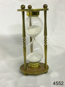
Instrument - Hourglass
... instruments. DEAD RECKONING (or Deduced Reckoning) Dead reckoning is the term used to describe the method of calculating the ship’s position from its speed and direction, used in early maritime travel, mostly in European waters. Both the (1) speed and the (2) direction of travel were recorded on a Traverse Board at half-hourly intervals during a helmsman’s watch of 4 hours. The navigator would record the readings in his ship’s log, plot them on his navigational...instruments. DEAD RECKONING (or Deduced Reckoning) Dead reckoning is the term used to describe the method of calculating the ship’s position from its speed and direction, used in early maritime travel, mostly in European waters. Both the (1) speed and the (2) direction of travel were recorded on a Traverse Board at half-hourly intervals during a helmsman’s watch of 4 hours. The navigator would record the readings in his ship’s log, plot them on his navigational ...An hourglass or sandglass is an instrument for measuring a defined time and can be used perpetually by simply turning it over immediately the top bulb empties. The clear blown glass is shaped into two equal sized bulbs with a narrow passage in the centre and contains uniform sized sand or glass particles in the lower bulb. The width of the neck regulates the constant flow of the particles. The glass is held in a stand with top and bottom of equal shape and size. Hourglasses can measure an infinite variety of time by gauging the size of the particles, the shape and size of the bulbs and the size of the passage between the bulbs, thus measuring hours or minutes or even seconds. Generally an hourglass sits between discs of wood at the ends, which are joined by long wooden spindles between the ends and tightened by screw caps. The length of time can be adjusted by adding or removing sand particles. The use of the marine sandglass (or hourglass) has been recorded in the 14th century in European shipping. A one minute sandglass was used in conjunction with the ship’s log for ‘dead reckoning’, (see below) that is, for measuring the ship’s speed through the water. They were also used to regulate ringing the ship’s timetable; for example a 4 hour sandglass was used for the length of the sailors’ watch, and a half hour timer for taking of readings for the ship’s log; the ship’s bell would be rung every half hour. It was usually the role of the cabin boy to watch and turn the sandglasses over at the exact time of them emptying their upper chambers and to ring the ship’s bell. Hourglasses have been used historically for many hundreds of years. Some have been used for timing church sermons, in cooking, in industry and at sea. Even today they are used for measuring the cooking time of eggs and timing a player’s turn in games such as Boggle and Pictionary. The sandglasses at sea were gradually replaced in the late 1700’s to early 1800’s by the more accurate chronometers (marine clocks) when they became reliable instruments. DEAD RECKONING (or Deduced Reckoning) Dead reckoning is the term used to describe the method of calculating the ship’s position from its speed and direction, used in early maritime travel, mostly in European waters. Both the (1) speed and the (2) direction of travel were recorded on a Traverse Board at half-hourly intervals during a helmsman’s watch of 4 hours. The navigator would record the readings in his ship’s log, plot them on his navigational chart and give his updated course directions to the next helmsman on watch, along with the cleared Traverse Board. This was a very approximate, but none-the-less helpful, method of navigation. The wooden Traverse Board was a simple pegboard with a diagram of a compass with eight peg holes along the radius to each of the compass points, plus a grid with ascending half hours in the left column and increasing ship’s speed in knots in a row across the column headings, with a peg hole in each of the intersecting cells. A number of wooden pegs were attached to strings on the board. By placing one peg consecutively in the direction’s radius hole, starting from the centre, and the speed holes when the half hourly reading was taken, a picture of speed and direction for the whole 4 hour watch was created. (1) To measure the ship’s speed a one minute hourglass timer was usually used to measure the ship’s speed through the water and help to calculate its longitude. A rope, with knots at regular standard intervals and a weight such as a log at the end, would be thrown overboard at the stern of the ship. At the same time the hourglass would be turned over and a seaman would start counting the number of knots on the rope that passed freely through his hands as the ship travelled. When the timer ran out the counting would be stopped. A timer of one minute (one-sixtieth of an hour), knots spaced one-sixtieth of a nautical mile apart, and simple arithmetic easily gave the speed of the ship in nautical miles per hour ("knots"). This would be recorded every half hour. The speed could however be inaccurate to the travel being affected by ocean currents and wind. (2) To calculate the ship’s direction a compass sighting would be recorded each half hour.Marine hourglasses or sandglasses were used from around the 14th to 19th century during the time of sailing ships. This hourglass is representative of that era, which is during the time of the colonisation of Australia. Hourglass or sandglass; an instrument used to measure time. Two equal sized clear glass bulbs joined with a narrow passage between them, containing equal sized particles of sand grains in lower bulb. Glass sits in a brass collar at each end, in a frame comprising 3 decorative brass columns or posts, each attached top and bottom, using round screw-on feet, to round brass discs. Disc have Roman numerals for the numbers 1 - 12 pressed into their inner surfaces and hieroglyphics on the outer surfaces. Roman numerals on inner surface of discs " I II III IV V VI VII VIII IX X XI XII " Hieroglyphics impressed on outer surface of discsflagstaff hill, warrnambool, shipwrecked coast, flagstaff hill maritime museum, maritime museum, shipwreck coast, flagstaff hill maritime village, great ocean road, horology, hourglass, hour glass, sandglass, sand glass, timing instrument, dead reckoning, deduced reckoning, finding latitude at sea, sandglass with hieroglyphics and roman numerals, hourglass with hieroglyphics and roman numerals, brass hourglass -
 Bendigo Military Museum
Accessory - INSTRUMENT - NAVIGATIONAL AID
... Bendigo Military Museum 37 - 39 Pall Mall Bendigo goldfields Navigational aid used during WW11 instruments military history - airforce aviation mechanics Scratched on inside of stainless steel surface of cover: A G Culvenor 46 Station St. ...Navigational aid used during WW11Instrument for altitudes & air speed corrections. Notebook with spiral binding attached inside.Scratched on inside of stainless steel surface of cover: A G Culvenor 46 Station St. Nunawading instruments, military history - airforce, aviation, mechanics -
 Frankston RSL Sub Branch
Sextant, Bubble
... This is an aviation navigation instrument used by the RAF and RAAF during the World War 2 era. ...This is an aviation navigation instrument used by the RAF and RAAF during the World War 2 era. ...Bubble Sextant model Mark 1XA type A.M. 6B/218 in protective storage box. Complete, with operation instructions. This is an aviation navigation instrument used by the RAF and RAAF during the World War 2 era. A sextant is used to measure the altitude of celestial bodies above a horizontal line of reference. A navigator can use the horizon as this line of reference, but when an aircraft is above the clouds or flying at night, the navigator can’t see the horizon. The bubble sextant solves this problem by providing an artificial horizon.The storage case has a label with the following: "A.M. 6B/218 MK IX A" and the number "10772/42 (V)" -
 Montmorency–Eltham RSL Sub Branch
Equipment - Navigational Computer
... NAVIGATIONAL Mk. III D. (Other inscriptions including instructions for use and scales for various measurements) "AB" hand written on strap (owner's initials?) Rectangular calculating instrument ...Rectangular calculating instrument with (1) 'hinged lid' fitted with circular rotating dial for setting/reading altitude, speed, distance and temperature, (2) notebook inside lid, (3) circular dial with perspex cover, beneath which is (4) graph chart, moveable up-and-down by means of rotating knob on side of device. Curved brackets and elasticized straps on back for strapping onto pilot's leg.R.A.A.F. Ident. No. G6B/145 Serial No. WG/2233 COMPUTER NAVIGATIONAL Mk. III D. (Other inscriptions including instructions for use and scales for various measurements) "AB" hand written on strap (owner's initials?) -
 Queenscliffe Maritime Museum
Instrument - Bearing compass hand held
... instrument makers who made fine quality compasses, ships clocks, inclinometers, sextants and chandlery items for over 140 years. Their "Dead Beat" compass, which was well dampened to reduce oscillation, was fitted to many Allied ships during the Second World War. Sestrel was their famous Trade Mark brand. The company was sold to John Lilley & Gillie Ltd and SIRS Navigation, both UK companies, in 1993. Example of a hand held compass used ...Formerly of Station Works, Wakering Road, Barking, Essex, Henry Browne & Son were important British compass makers. The company was founded in the nineteenth century in Barking and London. They were respected English instrument makers who made fine quality compasses, ships clocks, inclinometers, sextants and chandlery items for over 140 years. Their "Dead Beat" compass, which was well dampened to reduce oscillation, was fitted to many Allied ships during the Second World War. Sestrel was their famous Trade Mark brand. The company was sold to John Lilley & Gillie Ltd and SIRS Navigation, both UK companies, in 1993. Example of a hand held compass used in WWIIA Sestrel hand held bearing compass with wooden handle in own glass fronted, wooden container.Sestrel Henry Browne & Son Ltd Barking Londoncompass, navigation -
 Queenscliffe Maritime Museum
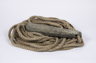
Equipment - Sounding lead line
... Since at least the sixth century B.C. the sounding lead or sounding weight was in use in the Mediterranean area for maritime navigation. It is the oldest known marine navigational instrument and it remained a primary navigational aid in coastal waters and rivers well into the twentieth century. ...Although the provenance cannot be confirmed it is believed that this lead possibly originated from the SS Time.Since at least the sixth century B.C. the sounding lead or sounding weight was in use in the Mediterranean area for maritime navigation. It is the oldest known marine navigational instrument and it remained a primary navigational aid in coastal waters and rivers well into the twentieth century.A sounding lead with rope line attached. One surviving leather fathom depth marker is spliced into the rope.sound lead, navigation -
 Queenscliffe Maritime Museum
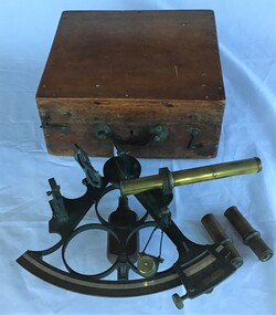
Instrument - Sextant in wooden box
... Queenscliffe Maritime Museum 2 Wharf St Queenscliff geelong-and-the-bellarine-peninsula Sextant used by Bill Virtue, an apprentice on the Adelaide Steamship Co. ship 'Manoora' in 1957 Label on the book indicates that the sextant was examined by the National Physical Museum Kew observatory, Richmond Surrey England in 1901 sextant Navigation 'Manoora' Adelaide Steamship Co Bill Virtue Examined by National Physical Museum Kew Observatory Richmond Surrey Eng 1901 Sextant in timber box made around 1901 in the UK. Instrument ...Sextant used by Bill Virtue, an apprentice on the Adelaide Steamship Co. ship 'Manoora' in 1957Label on the book indicates that the sextant was examined by the National Physical Museum Kew observatory, Richmond Surrey England in 1901Sextant in timber box made around 1901 in the UK.Examined by National Physical Museum Kew Observatory Richmond Surrey Eng 1901sextant, navigation, 'manoora', adelaide steamship co, bill virtue -
 Flagstaff Hill Maritime Museum and Village
Instrument - Ship Log
... TAFFRAIL LOGS A taffrail log is a nautical instrument used for measuring the speed of a vessel, providing vital navigational information to be calculated, such as location and direction. ...TAFFRAIL LOGS A taffrail log is a nautical instrument used for measuring the speed of a vessel, providing vital navigational information to be calculated, such as location and direction. ...The ship's log part, called a fish, is likely to be from a mechanical taffrail log system. It was recovered from the wreck site of the barque, the 1840-1852 Grange. There are no marks on the fish to identify its maker or model. It is part of the John Chance Collection. This ‘fish’ is part of an early to mid-1800s ship's log. It would likely have been part of a taffrail log connected to a rotor (also called propeller, spinner) by a strong line, and the other end connected by a line to a dial mounted on the taffrail, or stern rail, at the stern of the vessel. As the propeller rotated through the water it would spin the log, which in turn would cause a number to register on the dial, showing the current speed in knots; one knot equals one nautical mile per hour. TAFFRAIL LOGS A taffrail log is a nautical instrument used for measuring the speed of a vessel, providing vital navigational information to be calculated, such as location and direction. A log has been used to measure the speed of a vessel since the 1500s. A simple piece of wood was tied to a long line and thrown into sea at the back of the vessel. The rope was knotted all along at equal distances apart. On a given signal the log line was pulled back into the vessels, the knots counted until the log came up, then the figures were calculated by a navigator In 1802 the first successful mechanical log available for general use was invented by Edward Massey. It had a rotor 'V' section connected to a recording mechanism. The water’s movement rotated the rotor, which intern sent the movement to the recorder. There are examples of this invention available to see in some of the maritime museums. Thomas Walker, nephew of Edward Massey, improved on Massey’s design, and Walker and his son took out a patent on the A1 Harpoon Log. In 1861. Both Massey and Walker continued to improve the designs of the taffrail log. New designs were still being introduced, even up to the 1950s. THE GRANGE, 1840-1858- The wooden barque ’Grange’ was a three-masted ship built in Scotland in 1840 for international and coastal trade. On March 22, 1858, the Grange set sail from Melbourne under Captain A. Alexander, carrying a cargo of ballast. The barque had left the Heads of Phillip Bay and was heading west along the Victorian coast towards Cape Otway. The ship struck Little Haley’s Reef at Apollo Bay due to a navigational error and was stuck on the rocks. The crew left the ship carrying whatever they could onto the beach. Eventually, the remains of the hull, sails and fittings were salvaged before the wreck of the Grange broke up about a month later. About 110 years later, in 1968, the wreck of the Grange was found by divers from the Underwater Explorers Club of Victoria. They were amazed to find a unique, six to nine pound carronade (type of small cannon) and a cannonball on the site. There have been no other similar carronades recorded. In that same year the anchor of the Grange was recovered by diver John Chance and Mal Brown. The ship’s log is significant historically as an example of hardware used when building wooden ships in the early to mid-19th century. The ship’s log is historically significant as an example of the work and trade of blacksmith. The ship’s log also has significant as it was recovered by John Chance, a diver from the wreck of the Grange in the 1968. Items that come from several wrecks along Victoria's coast have since been donated to the Flagstaff Hill Maritime Village’s museum collection by his family, illustrating this item’s level of historical value. The ship’s log is historically significant for its association with the 1840s wooden barque, the Grange. The Grange is an historical example of a Scottish built vessel used for international and coastal trader of both cargo and passengers in the mid-19th century. The Grange is an example of an early ship, designed with a wooden hull. It is significant as a ship still available to divers along the south coast of Victoria, for research and education purposes. The Grange is an example of a mid-19th century vessel that carried a weapon of defence onboard. Ship log fitting, called a fish; part of a brass navigational instrument, likely to be from a taffrail log. The metal is a tan colour and has rough surface with a sheen, and discolouration in places. Its basic shape is a hollow cylinder with ends tapering to a smaller size. In the centre there are opposing openings cut out, showing a rough texture inside. One end on the cylinder is closed with a ring and shank installed, fixed by an embedded screw through the end of the cylinder. There are no inscriptions.flagstaff hill, warrnambool, flagstaff hill maritime museum, maritime museum, shipwreck coast, flagstaff hill maritime village, great ocean road, west coast trader, apollo bay, mid-19th century shipwreck, the grange, scottish barque, little henty reef, captain a alexander, underwater explorers club of victoria, vhr 5297, coastal trader, wooden shipwreck, john chance, wooden ship, taffrail log, marine instrument, marine technology, navigation, nautical instrument, mechanical log, nautical navigation, navigation equipment, scientific instrument, ship log, ship log register, ship speed, taff rail log, patent log, towed log, taffrail log fish, edward massey, thomas walker -
 Flagstaff Hill Maritime Museum and Village
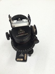
Plane Compass, 1941-1943
... It also therefor is of social significance as many Australians served in the Military forces at that time and the item is complete and in very good condition. flagstaff hill warrnambool shipwrecked-coast flagstaff-hill flagstaff-hill-maritime-museum maritime-museum shipwreck-coast flagstaff-hill-maritime-village trough compass navigation instrument surveyor's instrument j w handley artillery australian army trough plane compass world war 2 J.W.H./V Mark 11 D↑D. Made by J W Handley Richmond Melbourne, Victoria. Serial No 353 A plane table compass, sometimes referred to as a trough compass, used ...This compass is the type used by an artillery unit of the Australian Military Forces during World War 2 and made by J W Handley. Although having owned the factory site since 1935 at 657 Victoria St J W Handley began to produce various items for the Australian Military forces after purchasing and expanding the factory to 655 Victoria St. It appears that he, or some one else may already have been occupying the site for industrial purposes, such as (Manufacturing, Foundry and Electroplating) since at least 1929. J W Handley Pty Ltd was actively producing items for the Military during the war years, a newspaper article from 1939 shows the factory in production and employing 420 people during 1939. J W Handley after the war moved into producing other non military items including a range of fishing reels. The company ceased trading in 1987 and was deregistered as J W Handley Pty Ltd in 1990.The item demonstrates the industrial capability of Australia at the start of World War 2. This item is actively sort by collectors of Australian Military memorabilia and represents a time in Australian history when the country was at war and the general population was concerned about an invasion from Japanese forces. It also therefor is of social significance as many Australians served in the Military forces at that time and the item is complete and in very good condition.A plane table compass, sometimes referred to as a trough compass, used by surveyors and artillery crew to accurately establish magnetic north. The compass is precision machined of brass material with a long needle to ensure accuracy. The compass scale is marked with a centre zero (for magnetic north) and graduations indicating plus and minus five degrees. The compass is housed in a protective wooden case with a sliding lid. The lid has a brass slide which locks the compass needle during periods when the compass is not in use.J.W.H./V Mark 11 D↑D. Made by J W Handley Richmond Melbourne, Victoria. Serial No 353flagstaff hill, warrnambool, shipwrecked-coast, flagstaff-hill, flagstaff-hill-maritime-museum, maritime-museum, shipwreck-coast, flagstaff-hill-maritime-village, trough compass, navigation instrument, surveyor's instrument, j w handley, artillery, australian army, trough, plane compass, world war 2 -
 Flagstaff Hill Maritime Museum and Village
Plane Compass, 1941-1943
... It also therefor is of social significance as many Australians served in the Military forces at that time and the item is complete and in very good condition. flagstaff hill warrnambool shipwrecked-coast flagstaff-hill flagstaff-hill-maritime-museum maritime-museum shipwreck-coast flagstaff-hill-maritime-village trough compass navigation instrument surveyor's instrument j w handley artillery australian army trough plane compass world war 2 J.W.H./V Mark 11 D↑D. Made by J W Handley Richmond Melbourne, Victoria. Serial number 92 A plane table compass, sometimes referred to as a trough compass, used ...This compass is the type used by an artillery unit of the Australian Military Forces during World War 2 and made by J W Handley. Although having owned the factory site since 1935 at 657 Victoria St J W Handley began to produce various items for the Australian Military forces after purchasing and expanding the factory to 655 Victoria St. It appears that he, or some one else may already have been occupying the site for industrial purposes, such as (Manufacturing, Foundry and Electroplating) since at least 1929. J W Handley Pty Ltd was actively producing items for the Military during the war years, a newspaper article from 1939 shows the factory in production and employing 420 people during 1939. J W Handley after the war moved into producing other non military items including a range of fishing reels. The company ceased trading in 1987 and was deregistered as J W Handley Pty Ltd in 1990.The item demonstrates the industrial capability of Australia at the start of World War 2. This item is actively sort by collectors of Australian Military memorabilia and represents a time in Australian history when the country was at war and the general population was concerned about an invasion from Japanese forces. It also therefor is of social significance as many Australians served in the Military forces at that time and the item is complete and in very good condition.A plane table compass, sometimes referred to as a trough compass, used by surveyors and artillery crew to accurately establish magnetic north. The compass is precision machined of brass material with a long needle to ensure accuracy. The compass scale is marked with a centre zero (for magnetic north) and graduations indicating plus and minus five degrees. The compass is housed in a protective wooden case with a sliding lid. The lid has a brass slide which locks the compass needle during periods when the compass is not in use.J.W.H./V Mark 11 D↑D. Made by J W Handley Richmond Melbourne, Victoria. Serial number 92 flagstaff hill, warrnambool, shipwrecked-coast, flagstaff-hill, flagstaff-hill-maritime-museum, maritime-museum, shipwreck-coast, flagstaff-hill-maritime-village, trough compass, navigation instrument, surveyor's instrument, j w handley, artillery, australian army, trough, plane compass, world war 2 -
 Flagstaff Hill Maritime Museum and Village
Plane Compass, 1941-1943
... It also therefor is of social significance as many Australians served in the Military forces at that time and the item is complete and in very good condition. flagstaff hill warrnambool shipwrecked-coast flagstaff-hill flagstaff-hill-maritime-museum maritime-museum shipwreck-coast flagstaff-hill-maritime-village trough compass navigation instrument surveyor's instrument j w handley artillery australian army trough plane compass world war 2 J.W.H./V Mark 11 D↑D. Made by J W Handley Richmond Melbourne, Victoria. Serial number 1279 A plane table compass, sometimes referred to as a trough compass, used ...This compass is the type used by an artillery unit of the Australian Military Forces during World War 2 and made by J W Handley. Although having owned the factory site since 1935 at 657 Victoria St J W Handley began to produce various items for the Australian Military forces after purchasing and expanding the factory to 655 Victoria St. It appears that he, or some one else may already have been occupying the site for industrial purposes, such as (Manufacturing, Foundry and Electroplating) since at least 1929. J W Handley Pty Ltd was actively producing items for the Military during the war years, a newspaper article from 1939 shows the factory in production and employing 420 people during 1939. J W Handley after the war moved into producing other non military items including a range of fishing reels. The company ceased trading in 1987 and was deregistered as J W Handley Pty Ltd in 1990.The item demonstrates the industrial capability of Australia at the start of World War 2. This item is actively sort by collectors of Australian Military memorabilia and represents a time in Australian history when the country was at war and the general population was concerned about an invasion from Japanese forces. It also therefor is of social significance as many Australians served in the Military forces at that time and the item is complete and in very good condition.A plane table compass, sometimes referred to as a trough compass, used by surveyors and artillery crew to accurately establish magnetic north. The compass is precision machined of brass material with a long needle to ensure accuracy. The compass scale is marked with a centre zero (for magnetic north) and graduations indicating plus and minus five degrees. The compass is housed in a protective wooden case with a sliding lid. The lid has a brass slide which locks the compass needle during periods when the compass is not in use.J.W.H./V Mark 11 D↑D. Made by J W Handley Richmond Melbourne, Victoria. Serial number 1279flagstaff hill, warrnambool, shipwrecked-coast, flagstaff-hill, flagstaff-hill-maritime-museum, maritime-museum, shipwreck-coast, flagstaff-hill-maritime-village, trough compass, navigation instrument, surveyor's instrument, j w handley, artillery, australian army, trough, plane compass, world war 2 -
 Flagstaff Hill Maritime Museum and Village
Instrument - Marine Telescope, 1870-1880
... instruments were used in physics, chemistry, and biology. The products he designed and manufactured included spectroscopes, telescopes, microscopes, barometers, photometers, cameras, ophthalmologist, and electrical equipment such as electric lamps. John Browning was born around 1831 in Kent, England. His father, William Spencer Browning, was a maker of nautical instruments. John Browning's great-grandfather was also an instrument maker as well as John’s brother Samuel Browning of the firms Spencer & Browning and Spencer, Browning & Rust, who also manufactured navigational...instruments were used in physics, chemistry, and biology. The products he designed and manufactured included spectroscopes, telescopes, microscopes, barometers, photometers, cameras, ophthalmologist, and electrical equipment such as electric lamps. John Browning was born around 1831 in Kent, England. His father, William Spencer Browning, was a maker of nautical instruments. John Browning's great-grandfather was also an instrument maker as well as John’s brother Samuel Browning of the firms Spencer & Browning and Spencer, Browning & Rust, who also manufactured navigational ...This telescope was amongst various items collected from a sea dive in Port Phillip Bay. The diver was the caretaker of the Port Lonsdale Lighthouse, who dived on various wrecks in the bay during the 1960's. After the caretaker's death, his son sold off many of the shipwreck artefacts. The telescope was purchased from the caretaker's son in the 1990's by a previous owner of the Marine Shop, Queenscliff, Victoria. John Browning was particularly well known for his scientific advances in the fields of spectroscopy, astronomy, and optometry. Between 1856 and 1872, Browning acquired provisional patents for designs of numerous scientific instruments. He was also the recipient of an award at the 1862 International Exhibition held in London. Also recognised for his temperature-compensated aneroid barometer. Browning's scientific instruments were used in physics, chemistry, and biology. The products he designed and manufactured included spectroscopes, telescopes, microscopes, barometers, photometers, cameras, ophthalmologist, and electrical equipment such as electric lamps. John Browning was born around 1831 in Kent, England. His father, William Spencer Browning, was a maker of nautical instruments. John Browning's great-grandfather was also an instrument maker as well as John’s brother Samuel Browning of the firms Spencer & Browning and Spencer, Browning & Rust, who also manufactured navigational instruments. The latter firm was in operation in London from 1784 to 1840 and was succeeded by the firm of Spencer, Browning & Co. John Browning initially intended to follow the medical profession and entered Guy's Hospital, a teaching hospital and a school of medicine. Despite having passed the required examinations, however, he abandoned his plans. Instead, he apprenticed with his father, William Spencer Browning. At the same time, in the late 1840s, he was a student attending the Royal College of Chemistry several days per week. By the early 1870s, practical optics had become John Browning's primary interest, and he listed his occupation as an optician on the census records from 1871 to 1901. He was well known among London's ophthalmic surgeons for his various ophthalmic instruments. He had a large part in reforming the art of crafting spectacles. Other achievements were as an author of the book, How to Use Our Eyes and How to Preserve them by the Aid of Spectacles. Published in 1883, the book included thirty-seven illustrations, including a diagram demonstrating the anatomy of the eye. In 1895, he was one of the founders of the "British Ophthalmology" the first professional organisation for optometry. He was not only its first president but also registered as its first member so many considered him to be the first professional optometrist. Other professional organisations he belonged too was as a member of “The Aeronautical Society of Great Britain”. In 1871 constructing the first wind tunnel located at Greenwich Marine Engineering Works. He was also a member of other scientific organisations, such as the “Microscopical Society of London”, the “Meteorological Society”, and the “Royal”. Then in 1908 the company of W. Watson & Son, opticians and camera makers, took over John Browning's company since 1901 John Browning had been semi-retired but in 1908 he fully retired and moved to Bournemouth in Hampshire. He died in Cheltenham, Gloucestershire in 1925.The telescope is significant for its association with one of the world’s leading scientific instrument makers and inventor of the 19th and early 20th century. It is believed the donation came off a wreck either in Port Philip Bay or between Point Lonsdale and the Nepean Heads making it a significant maritime historical artefact. Its provenance is good given it was taken off a wreck in this area by the Point Lonsdale lighthouse caretaker. Examples of John Browning's telescopes because of their scientific and historical importance are highly valued by collectors.Marine style single draw brass telescope with a sunshade. The single draw has no split and the second cartridge is held in a long brass tube within the single draw, mounted from the objective end. The eyepiece is flat and at the end of the first draw in a very faded engraving that is believed to read "John Browning, 63 Strand, and should read London under the word strand but this is hard to establish given the engravings condition. This interpretation of the engraving has been arrived at by examination of other John Browning telescope engraving examples."John Browning, engraved to the first tube in copper plate style "63 STRAND" Engraved under in capital textflagstaff hill, flagstaff hill maritime museum and village, warrnambool, maritime museum, maritime village, great ocean road, shipwreck coast, shipwreck artefact, port phillip bay, port lonsdale lighthouse, wreck, 1960’s diver, queenscliff marine shop, john browning, telescope, spectroscopy, optometry, scientific instruments, william spencer browning, optician, navigational instrument, microscopical society of london, aeronautical society, marine technology -
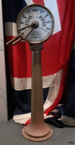 Flagstaff Hill Maritime Museum and Village
Equipment - Ship's Telegraph section, Chadburn & Sons, 1875-1898
... instruments and marine gauges. The firm was granted the Prince Albert Royal Warrant in the late 19th century. In 1870, William Chadburn applied for a patent for his navigational communication device for use on ships. ...used with an Engine Room section, represents late-19th-century change and progress in communication and navigation at sea. This type of equipment was still in use in the mid-20th century. It is significant for its association with its maker, Chadburn & Son, of Liverpool, a well-known marine instrument maker whose work was recognised by English Royalty, and whose products were selected to supply similar equipment for use on the RMS Titanic. ...The ship’s telegraph section was once part of the navigational equipment of the famous paddle steamer, PS Hygeia, and was later installed on Flagstaff Hill’s exhibit, the steamer Rowitta. This is the Bridge Section of a ship’s telegraph, a Duplex Gong model, made by Chadburn & Son of Liverpool. The gong sounded two signals whenever the navigational commands to change the speed or direction were given by the ship’s pilot. Communication between the ship’s pilot and the engine room in the late 19th to the mid-20th centuries was made with a system called an Engine Order Telegraph (E.O.T.) or ship’s telegraph. The equipment has two parts, the Bridge Section and the Engine Room Section. The Bridge Section was usually mounted onto a pedestal, and the Engine Room Section was attached to a vertical surface. The standard marine commands were printed or stamped around the face of the dial and indicated by a pointer or arrow that was usually moved by a rotating brass section or handle. The ship’s pilot stationed on the Bridge of a vessel sends his Orders for speed and direction to the Engine Room with the E.O.T. He moves the lever or levers, depending on the number of engines the ship has, to change the indicator on the Bridge Section’s dial to point in the new direction and speed of travel. This change causes the Orders to be duplicated on the Engine Room Section’s dial and a bell or bells to signal the change at the same time. The engineer then adjusts the ship’s engines and steering equipment to follow the pilot’s Order. CHADBURN & SON, Liverpool- Chadburn Brothers, William and C.H., were joint inventors and well-established makers of optical and scientific instruments and marine gauges. The firm was granted the Prince Albert Royal Warrant in the late 19th century. In 1870, William Chadburn applied for a patent for his navigational communication device for use on ships. By 1875, Chadburn & Son was producing the brass Engine Order Telegraph in its plant at 71 Lord Street, Liverpool. In 1911, the ship, RMS Titanic, was launched, fitted with Chadburn & Sons E.O.T. The Chadburn Ship Telegraph Company Limited was registered in 1898 to take over Chadburn & Sons. In 1903, a large factory at Bootle, near Liverpool, and its products were being sold overseas. In 1920, electric-powered telegraphs were developed. In 1944, the name changed to Chadburn’s (Liverpool) Limited. In 1968, the company became Chadburn Bloctube Ltd. In 2000, the company, now Bloctube Marine Limited, was still manufacturing ship telegraphs. The P.S. HYGEIA 1890-1932: - This ship’s telegraph was installed on the new paddle steamer, PS Hygeia, one of three iconic pleasure steamers famous for providing regular services in Port Phillip Bay, Victoria, to thousands of passengers between the ports of Queenscliff, Sorrento, Portsea, Dromana, Rosebud, Rye, and Mornington. It joined the Ozone and the Weeroona, all three described as being glamorous, powerful and fast. Its ticket office was on the pier itself. The P.S. Hygeia was built in Yorker, Scotland, in 1890, by Napier, Sharks & Bell. It was registered in Melbourne, Australia, by Hubbart, Parker & Co. in 1891. The steel ship was 92 metres long, able to travel at 22 knots, and licensed to carry over 1600 passengers in luxury, with even a barber shop on board. The regular service between the ports in Port Phillip Bay, Victoria, continued for over 40 years. With the decline in passenger demand, the service wound down. The Hygeia was sold to H.M. Morris in 1931 for demolition and breaking up. Equipment, fittings, and even lifebuoys were sold, with many items purchased by people who had some connection to the Hygeia. On August 25th, 1931, what was left of the vessel departed Port Melbourne and eventually, in June 1932, it was laid to rest at the ships’ graveyard outside Port Phillip Heads. The SS ROWITTA 1909-2015: - The ship’s telegraph was originally installed on the PS Hygeia. It was purchased when the Hygeia was broken up in 1931 and later installed, in 1975, on Flagstaff Hill’s SS Rowitta, an exhibit greatly enjoyed by the public until it was demolished in 2015. The ferry “SS Rowitta” was built in 1909 in Hobart, Tasmania. The timber steam ferry was built using planks of Huon and Karri wood. It was a favourite with sightseeing passengers steaming along Tasmania’s Tamar and Derwent rivers for 30 years. Rowitta was also known as Tarkarri and Sorrento and had worked as a coastal trading vessel between Devonport and Melbourne, and Melbourne, Queenscliff and Sorrento. The vessel had given over 100 years of service and pleasure. This Bridge section of a ship’s Engine Order Telegraph, used with an Engine Room section, represents late-19th-century change and progress in communication and navigation at sea. This type of equipment was still in use in the mid-20th century. It is significant for its association with its maker, Chadburn & Son, of Liverpool, a well-known marine instrument maker whose work was recognised by English Royalty, and whose products were selected to supply similar equipment for use on the RMS Titanic. The ship’s telegraph is also significant for its association with the paddle steamer PS Hygeia, one of three iconic steamers that transported thousands of passengers from port to port within Port Phillip Bay, Victoria, for over 40 years from the 1890s to the 1930s. Queenscliff Borough remembers the Hygeia by naming a road near the pier Hygeia Drive. The Hygeia is registered on the Victorian Heritage Database as a vessel of significance, VHR S329. In 1901, Hygeia had the privilege of carrying their Royal Highnesses, the Duke and Duchess of York, from Mornington to St Kilda Pier, Melbourne, during their Royal visit celebrating the Federation of Australia. The ship’s telegraph is also important for its connection with the Rowitta, a large exhibit on display at Flagstaff Hill Maritime Village, aiding maritime education for over 40 years. It represented the importance of coastal traders to transport, trade and communication along the coast of Victoria, and before the availability of rail and motor vehicles, serving many roles. Bridge section of a Ship’s Telegraph or Engine Order Telegraph (E.O.T.). The round, double-sided, painted glass dial is inside a brass case behind glass. It is fitted onto an outward tapering brass pedestal with a round base. The brass indicator arrows between the handles point simultaneously to both sides of the dial when moved. An oval brass maker’s plate is attached to the top of the case. The dial’s faces have inscriptions that indicate speed and direction, and the front face and plate include the maker’s details. A serial number is stamped on the collar where the dial is fitted to the pedestal. The ship’s telegraph is a Duplex Gong model, made by Chadburn & Son of Liverpool. It was originally part of the navigational fittings on the paddle steamer, PS Hygeia.Dial, maker’s details: “PATENT “DUPLEX GONG” TELEGRAPH / CHADBURN & SON / TELEGRAPH WORKS / PATENTEES & MANUFACTURERS / 11 WATERLOO ROAD / LIVERPOOL” LONDON / 105 FENCHURCH STREET” “NEWCASTLE / 85 QUAY + SIDE” “GLASGOW / 69 ANDERSON QUAY” “PATENT” Dial instructions: “FULL / HALF/ SLOW / FINISHED WITH ENGINES / STOP STAND BY / SLOW / HALF / FULL / ASTERN / AHEAD” Maker’s plate: “CHADBURN / & SON / PATENT / LIVERPOOL” Serial number: “22073”flagstaff hill, warrnambool, maritime village, maritime museum, shipwreck coast, great ocean road, engine order telegraph, e.o.t., navigational instrument, communication device, ship’s telegraph, engine room section, bridge section, rms titanic, chadburn & son, chadburn brothers, william chadburn, chadburn ship telegraph company, chadburns, duplex gong, liverpool, ss rowitta, navigation, marine technology, pilot’s orders, steam power, hobart, tasmania, devonport, tasmanian-built, ferry, steam ferry, steamer, 1909, early 20th century vessel, passenger vessel, tamar trading company, launceston, george town, sorrento, tarkarri, speculant, peter mcgennan, p j mcgennan & co. port phillip ferries pty ltd, melbourne, coastal trader, timber steamer, huon, karri, freighter, supply ship, charter ferry, floating restaurant, prawn boat, lakes entrance, ps hygeia, paddle steamer, pleasure steamer, port phillip bay, queenscliff, portsea, dromana, rosebud, rye, mornington, hubbart parker & co, 1890, 1903, h.m. morris, hygeia -
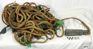 Flagstaff Hill Maritime Museum and Village
Equipment - Lead line
... The lead line or hand lead is a simple navigational instrument used as a depth finder to measure the depth of water under the ship’s keel and to take samples of the sea bed. ...Flagstaff Hill Maritime Museum and Village 89 Merri Street Warrnambool great-ocean-road The lead line or hand lead is a simple navigational instrument used as a depth finder to measure the depth of water under the ship’s keel and to take samples of the sea bed. ...The lead line or hand lead is a simple navigational instrument used as a depth finder to measure the depth of water under the ship’s keel and to take samples of the sea bed. The long line may be marked at regular intervals with tags of different coloured and textured fabric, such as rope, leather and cloth. Each tag was a code to represent a certain depth. The leadsman’s eyes and hands could distinguish the depth easily as he drew in the lead line, day or night and in poor weather conditions. A standard set of codes for the tags was used so that the depth of the sea could be easily and quickly read. The measurement used was a Fathom, which equals 1.83 metres. The codes were: - 2 fathoms = 2 strips of leather 3 fathoms = 3 strips of leather 5 fathoms = white duck fabric 7 fathoms = red bunting fabric 10 fathoms = leather with a hole 13 fathoms = blue serge fabric 15 fathoms = white duck fabric 17 fathoms = red bunting 20 fathoms = 2 knots The lead weight could be between 7 -14 pounds (3.5 – 6.5kg) and the rope would be approximately 25 fathoms (45m). The hollowed-out end of the weight would hold a stick substance such as tallow or wax, which would pick up samples from the sea bed which would show whether the vessel was close to, or far away from, the shore. The leadsman would stand at the front of the vessel and cast the lead line into the sea. When it hit bottom he would note the tag marker nearest the surface of the water and call out his finding. Then he would haul it up again and examine the kind of matter that adhered to the end of the weight, whether it be sand, mud, gravel, or the colour of it. This information would be given to the ship’s helmsman or navigator and would help indicate the proximity to the land.This handheld lead is an example of early marine navigational equipment used by sailors to travel the seas to measure the depth of the water and sample the nature of the seabed. It helps to understand the history and progress made from the very basic to the sophisticated technology of today.Lead line, sounding line or depth finder. The long length of rope has a heavy lead weight attached to the end. Coloured fabric tags are tied onto the rope at regular intervals, representing different depths. The concave base of weight holds sticky substances such as tallow or beeswax, providing an adhesive surface to collect samples of sea bed like sand, shells or pebbles. flagstaff hill, warrnambool, shipwrecked coast, flagstaff hill maritime museum, maritime museum, shipwreck coast, flagstaff hill maritime village, lead line, depth finder, hand lead, sounding lin, leadsmane, navigation instrument, leadline, hand lead line -
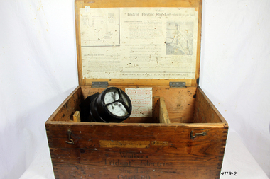 Flagstaff Hill Maritime Museum and Village
Instrument - Ship Log, Early 20th Century
... instrument maker and innovator of machinery. It demonstrates the huge leap taken to improve navigational accuracy at sea with an instrument that was in use for decades. flagstaff hill warrnambool shipwrecked-coast flagstaff-hill flagstaff-hill-maritime-museum maritime-museum shipwreck-coast flagstaff-hill-maritime-village ships log thomas walker & son Electric ships log marine navigation thomas ferdinand walker ship log Inscription "Admiralty patent number 3332" and "Walker Trident Electric Ship Log (Mark III), 15-25 volt". ...In times past the only way to measure a ship’s speed was to throw a wood log into the water and observe how fast it moved away from the ship. In the 16th century, the log was fastened to a rope knotted at set intervals. The log was thrown over the stern (back) of the vessel and a crew member counted the number of knots that were paid out in a set time. From this, they could estimate the vessel's speed through the water. This was known as streaming the log and is also the derivation of the knot as a measurement of nautical speed. Various manufacturers of nautical equipment had sought over the years to perfect the operation of determining a ship's speed and it wasn't until Thomas Walker and his son Ferdinand developed a mechanical system that eventually made this task became easy for marine navigators. Thomas Walker & Son were internationally renowned in the manufacturing of ship logs the founding father, Thomas Walker (1805–1871), an engineer in Birmingham, patented his mechanical log in 1878 which was a recording instrument that attached to a rail at the stern of a vessel connected by a long cord with a rotor which was towed behind the ship. The instrument dial then recorded the distance travelled. Thomas Walker first went into business to manufacture stoves at 58 Oxford Street Birmingham. Walker’s self-feeding stove was widely lauded at the Paris Exhibition of 1855, winning a prize medal and kickstarting the first of many notable innovations for the Walker family's manufacturing business. However, it wasn’t until working on an earlier ship’s log model invented by his Uncle that Thomas Walker became interested in the further development of this device, used to ascertain a ship’s speed. Walker continued to improve on the common log for the company of Massey & Sons and these improvements were deemed revolutionary. This log became a firm favourite of the West India Association (a British-based organisation promoting ties and trade with the British Caribbean), being the most common log in use for two generations. It took until 1861 for Thomas Walker and his son, Thomas Ferdinand Walker (1831-1921) to patent the first Walker log of many. Together, with the introduction of the A1 Harpoon Log two years later, they established the Walker Log Business as a force to be reckoned with. By his passing in 1871, Thomas Walker Snr had not only founded a family business with considerable staying power but also instilled a tradition of public service. Having sat as a representative on the Birmingham Town Council for 15 years and played an active role in public works, he was soon given the nickname of ‘Blue Brick Walker’. Much like his father, Thomas Ferdinand Walker changed the face of the maritime industry. His patent of 1897, the ‘Cherub’ log, was a notable departure from the past providing a far more accurate reading and replacing the majority of logs of the age. They were the first to produce an electric log (Trident) and the Walker factory was one of the first to introduce the 48-hour work week for employees.The ship log was invented and made by a significant marine instrument maker and innovator of machinery. It demonstrates the huge leap taken to improve navigational accuracy at sea with an instrument that was in use for decades.Ships Log, Walker Trident electric motor, in wooden box with instructions inside box. The motor dial with electric cord is still inside box.Inscription "Admiralty patent number 3332" and "Walker Trident Electric Ship Log (Mark III), 15-25 volt". On top of lid, hand written, is "G TAYLOR"flagstaff hill, warrnambool, shipwrecked-coast, flagstaff-hill, flagstaff-hill-maritime-museum, maritime-museum, shipwreck-coast, flagstaff-hill-maritime-village, ships log, thomas walker & son, electric ships log, marine navigation, thomas ferdinand walker, ship log -
 Flagstaff Hill Maritime Museum and Village
Plane Compass, 1941-1943
... navigation instrument surveyor's instrument j w handley artillery australian army trough plane compass world war 2 J.W.H./V Mark 11 D�D. Made by J W Handley Richmond Melbourne, Victoria. Serial number 1333 on box A plane table compass, sometimes referred to as a trough compass, used ...This compass is the type used by an artillery unit of the Australian Military Forces during World War 2 and made by J W Handley. Although having owned the factory site since 1935 at 657 Victoria St J W Handley began to produce various items for the Australian Military forces after purchasing and expanding the factory to 655 Victoria St. It appears that he, or some one else may already have been occupying the site for industrial purposes, such as (Manufacturing, Foundry and Electroplating) since at least 1929. J W Handley Pty Ltd was actively producing items for the Military during the war years, a newspaper article from 1939 shows the factory in production and employing 420 people during 1939. J W Handley after the war moved into producing other non military items including a range of fishing reels. The company ceased trading in 1987 and was deregistered as J W Handley Pty Ltd in 1990.The item demonstrates the industrial capability of Australia at the start of World War 2, this item is actively sort by collectors of Australian Military memorabilia and represents a time in Australian history when the country was at war and the general population was concerned about an invasion from Japanese forces. It also therefor is of social significance as many Australians served in the Military forces at that time and the item is complete and in very good condition.A plane table compass, sometimes referred to as a trough compass, used by surveyors and artillery crew to accurately establish magnetic north. The compass is precision machined of brass material with a long needle to ensure accuracy. The compass scale is marked with a centre zero (for magnetic north) and graduations indicating plus and minus five degrees. The compass is housed in a protective wooden case with a sliding lid. The lid has a brass slide which locks the compass needle during periods when the compass is not in use.J.W.H./V Mark 11 D�D. Made by J W Handley Richmond Melbourne, Victoria. Serial number 1333 on boxflagstaff hill, warrnambool, shipwrecked-coast, flagstaff-hill, flagstaff-hill-maritime-museum, maritime-museum, shipwreck-coast, flagstaff-hill-maritime-village, trough compass, navigation instrument, surveyor's instrument, j w handley, artillery, australian army, trough, plane compass, world war 2 -
 Flagstaff Hill Maritime Museum and Village
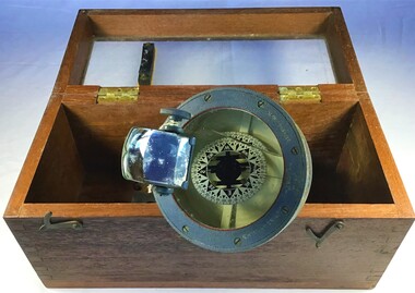
Instrument - Azimuth Compass, Early 20th Century
... instrument negretti & zambra london navigational instrument Compass Stamped "C.M.O. 9" on with Maker Negretti & Zambra London. Azimuth compass on tripod in a fitted wooden box with a round spirit level included, lid of box has three indented circles where the legs of the compass fit when it is set up for use. ...Negretti and Zambra 1850-1980s were optical instrument makers and mathematical instrument makers based in London, England. The firm of Negretti and Zambra was established in 1850 by Henry Negretti and Joseph Zambra who had formed a partnership. Their skill was immediately apparent when exhibiting at the 1851 Great Exhibition at Hyde Park, they were the only English instrument makers to receive a prize medal for meteorological instruments, resulting in their appointment as instrument makers to the queen, Greenwich observatory, and the British Meteorological Society. In 1853, when the Crystal Palace was re-erected in Sydenham, Negretti and Zambra became the official photographers of the Crystal Palace Company, which allowed them to photograph the interior and grounds of the new building. The firm made use of this access to produce a number of stereographs. Between 1855 and 1857 Negretti and Zambra commissioned photographer Pierre Rossier to travel to China to document the Second Opium War. Although Rossier subsequently was unable to accompany to Anglo-French forces in that campaign, he nevertheless produced a number of stereographs and other photographs of China, Japan, the Philippines and Siam (now Thailand), which Negretti and Zambra published and that represented the first commercial photographs of those countries. In 1856 Negretti and Zambra sponsored a photographic expedition to Egypt, Nubia and Ethiopia conducted by Francis Firth. In 1864 Negretti and Zambra (themselves) photographed Shakespeare's House at Stratford on Avon. A sepia photograph was then pasted onto card 4" × 2.5". This was then presented to visitors to the Crystal Palace to enable them to compare it with the model erected by Mr E. T. Parr in the Centre Transept. The card itself is headed "Crystal Palace April 23rd 1864." That year they also published a book, titled A Treatise on Meteorological Instruments, (which was reprinted in 1995). Throughout World War One Negretti and Zambra were entirely engaged in the production of various instruments for the Ministry of Munitions. They developed many instruments for the Air Ministry including a mercury-in-steel distance thermometer for taking the oil and air temperatures in aircraft which was patented in 1920. In 1946 the company went private and in 1948 the company was made public, and by 1950 Negretti and Zambra had 821 employees in Britain. In order to increase production and to safeguard future development in 1964, they purchased a modern factory at Aylesbury for all their production. In 1981 Negretti and Zambra were taken over by a group of financial institutions in the form of Western Scientific Instruments and in 1985 the company was acquired by Meggitt Holdings.The subject compass is just one type of the many marine and scientific, optical items this company produced over it’s life time. Negretti and Zambra were prolific manufactures of types of items as well as being very prominent in photography pioneering new innervation's and sponsoring expeditions to little known countries to document peoples daily lives and culture through photography.Azimuth compass on tripod in a fitted wooden box with a round spirit level included, lid of box has three indented circles where the legs of the compass fit when it is set up for use. Stamped "C.M.O. 9" on with Maker Negretti & Zambra London.flagstaff hill, warrnambool, flagstaff-hill, flagstaff-hill-maritime-museum, shipwreck-coast, flagstaff-hill-maritime-village, azimuth compass, nautical instrument, negretti & zambra london, navigational instrument, compass -
 Flagstaff Hill Maritime Museum and Village
Taffrail log, Late 19th Century
... navigational use. The firm became John Bliss & Son in 1855 and John Bliss & Co. in 1857. It remained in business until 1957. Truman Hotchkiss, a sea captain from Stratford, Connecticut, designed a mechanical Taff rail log in which the recording mechanism was placed on taffrail (or upper part of the stern) of the ship. After acquiring the rights to Hotchkiss’s patents of 1864 and 1867, John Bliss & Co. began advertising the "American Patent Taffrail Log." The firm also offered mechanical logs based on patents granted to John Bliss, Jnr and his brother George, as well as English instruments...navigational use. The firm became John Bliss & Son in 1855 and John Bliss & Co. in 1857. It remained in business until 1957. Truman Hotchkiss, a sea captain from Stratford, Connecticut, designed a mechanical Taff rail log in which the recording mechanism was placed on taffrail (or upper part of the stern) of the ship. After acquiring the rights to Hotchkiss’s patents of 1864 and 1867, John Bliss & Co. began advertising the "American Patent Taffrail Log." The firm also offered mechanical logs based on patents granted to John Bliss, Jnr and his brother George, as well as English instruments ...John Bliss (1795-1857) was born in Connecticut, trained as a silversmith and clock maker in Vermont, and began in business as a jeweller in New York around 1830. In 1834, now trading as Bliss & Creighton, he made and marketed chronometers and other items for navigational use. The firm became John Bliss & Son in 1855 and John Bliss & Co. in 1857. It remained in business until 1957. Truman Hotchkiss, a sea captain from Stratford, Connecticut, designed a mechanical Taff rail log in which the recording mechanism was placed on taffrail (or upper part of the stern) of the ship. After acquiring the rights to Hotchkiss’s patents of 1864 and 1867, John Bliss & Co. began advertising the "American Patent Taffrail Log." The firm also offered mechanical logs based on patents granted to John Bliss, Jnr and his brother George, as well as English instruments based on Massey’s and Walker’s patents.The SPECULANT is historically significant as the largest ship to have been registered in Warrnambool, and is believed to have been the largest barquentine to visit Melbourne. It is evidence of the final days of large commercial sailing vessels involved in the Victorian and New Zealand timber trade. The SPECULANT is listed on the Victorian Heritage Register VHR S626John Bliss Taffrail ship log incomplete, rope and spinner missing used on the vessel "Speculant " ( See "Notes" at the end of this document for further information) "Taffrail Log Patented Nov .. Apr .. June .. Sep 1.", dial registers 1/4, units and 10's. with 3 sets of dials, 2 with hands missingflagstaff hill, warrnambool, shipwrecked-coast, flagstaff-hill, flagstaff-hill-maritime-museum, maritime-museum, shipwreck-coast, flagstaff-hill-maritime-village, la bella, speculant, cumming and ellis, international timber trade, p. j. mcgennan and co. warrnambool, capt. james jacobsen, first mate: james munro, second mate: john scerling;, cook: b bond; a. b., s: v. sundring, s: h. hansen, s: b. melson, s: h. johnston, s: t. trumblen;, ordinary seaman: r. thompson, cape patton, c. ramsden, log, taffrail ship's log, ship log, john bliss, patent log, peter mcgennan -
 Flagstaff Hill Maritime Museum and Village
Functional object - Compass, mid-19th Century
... He also used this compass on the "Hannah Thompson", listed on the Victorian Heritage Register and known as being the first coastal trader to operate between Melbourne and Port Campbell. The compass is also a very fine example of maritime navigational instruments ...Captain Robilliard: James Arthur Robilliard was a sea captain and tentmaker, born on the 19th April 1843 at Saint Helier, Jersey. He trained there in his father's sail loft as a sailmaker. His first job as a sailor was in Liverpool, England, and in 1875, James Robilliard migrated to Australia as a mate on the "E.M. Young". James Robilliard and his family were amongst the early settlers who arrived along the Curdies River in the Heytesbury district of Western Victoria. In 1877, he became a Captain and would have used his compass from ship to ship. On 28th May 1877, in that same district, a small 3-masted schooner, the "Young Australian", was wrecked. This schooner had been built in 1864 at Jervis Bay, NSW. It had been on her way from Maryborough, Queensland, to Adelaide, under the command of Captain Whitfield, when it lost its mainmast in a heavy gale. It was beached at Curdies Inlet in Peterborough, Victoria. Captain Robilliard was placed in charge of the salvaging operation and recovered a good portion of the cargo. Not long after this incident, a Warrnambool shop owner, David Evans, found employment for James Robilliard with Evan Evans, who produced tents, sails, tarpaulins and similar goods; James already had the necessary skills for this work. Evan Evans was the same sailor rescued from the “Young Australian”. Soon after his rescue, Evan recalled he had a relative in Australia in a town called Warrnambool, and while walking in Timor Street, Warrnambool, he saw a sign over a shop that said “David Evans,” and once the two men met, Evan was warmly welcomed. David then helped his relative establish a tent and tarpaulin-making business there. Evan later transferred his successful business to a shop in Elizabeth St, Melbourne, under the name Evan Evans Pty. Ltd.) James Robilliard was a committed Christian and accredited Lay Preacher with the Methodist Church. He travelled around the local district leading the settlers in worship. On 14th November 1879, Captain Robilliard married Helen Beckett. Alfred and Selina Beckett and their family all attended the church at Brucknell, where Captain Robilliard preached. He was said to have been taken by their young daughter, Helen. James and Helen had ten children: James Arthur (Jnr), Henry William, Nellie Jessie, Alfred Albert, Rubena Nellie, De Jersy Norman, Clifford Beckett, Olive Ida, Frances Ridley Havergal and Nellie Elvie, all born in Victoria. In the 1880s, James Robilliard captained the cutter "Hannah Thompson" into Port Campbell, Victoria. This vessel was the first coastal trader to operate between Melbourne and Port Campbell. At one time, Captain Robilliard had to beach the "Hannah Thompson" for repairs. In 1923, the vessel was blown ashore in a gale and wrecked at Oberon Bay, at Wilson's Promontory. In 1889, the compass was saved by Captain James Arthur Robilliard from his sinking brigantine "Mary Campbell". This vessel was used to carry equipment for the Sydney Sugar Refinery's Mill in Southgate, NSW. The ship had been built in 1869 and traded for the next 20 years between Australian ports and rivers along the east coast, as well as regular ports in New Zealand. It was recognised by the Sydney Morning Herald as one of the best "carrying vessels in the timber trade". It had several owners over this time, the last one being Captain James A. Robilliard. On 29th April 1889, the "Mary Campbell", with Captain James A Robilliard as captain and owner, was on its way from Clarence River, NSW to Melbourne, Victoria with a cargo of railway girders for the Melbourne Harbour Trust. Captain Robilliard encountered a storm off Port Macquarie. He sailed the vessel south to about 40km east of Cape Hawke, near Tuncurry. At around 7 pm, he discovered that the cargo had shifted during the storm and the heavy girders had damaged the hull, causing a leak. The pumps were inadequate to stem the fast-flowing leak, and water soon filled the hull during the next two hours. Some of the crew began throwing the cargo overboard to lighten the vessel, hoping to keep it afloat until daylight. When the water reached over 2 meters in the hull, they realised their efforts were in vain. On the 30th April 1889, the crew left the vessel the ship was sinking fast, so they made for the shore. While still miles off Cape Hawke, all seven crew members, including the Captain, were rescued by the Government Tug "Rhea" and taken to Port Macquarie Hospital and later returned to Sydney in the vessel "Wellington". No cargo had been saved, and the consignment had been under-insured, only covered for half its value. The name of the last ship Captain Robilliard sailed is currently unknown; however, he sailed that ship from the port of Marlborough, Queensland, carting steel railway girders for the Geelong-to-Camperdown railway line. On this trip, the ship hit a storm, the cargo shifted, and the ship was wrecked along the NSW coast. After this, Captain Robilliard retired from the sea and began farming in Peterborough. In about 1897, verging on retirement, Capt. Robilliard superintended the Melbourne Sailors’ Home in Spencer Street, Melbourne, before being asked to leave this position in 1902 for trying to shut down a local hotel. On 6th May 1917, Captain James Arthur Robilliard J.P. died at Blackwood Park, in the Cobden district of Brucknell, the first Robilliard family homestead in Australia. He was buried in the Melbourne General Cemetery, Victoria. His wife Helen, passed away in 1947. This compass, once belonging to Captain James Arthur Robilliard, is of local and state historical significance for its use by the Captain with his vessel, the "Mary Campbell", a trading vessel that was bringing railway girders to the Melbourne Harbour Trust. He also used this compass on the "Hannah Thompson", listed on the Victorian Heritage Register and known as being the first coastal trader to operate between Melbourne and Port Campbell. The compass is also a very fine example of maritime navigational instruments manufactured and used in the mid-19th century. Marine compass, brass, in a wooden box with a separate, fitted lid. The compass card has sixteen points. The four principal points are marked: North with a star-shape, South with an “S”, East with an “E” and West with an “O” (French word OUEST). Each quadrant of the circle is numbered from 0 – 90 degrees. The card is floating in a liquid. The compass gimbal is attached to the sides of the box and to the front and back of the compass’ cylindrical brass frame. The mahogany coloured timber storage case is joined with brass nails. The centre of the lid has a folding decorative brass handle. The lid fits over the base and closes with a brass screw and hook on both front and back. Maker: Dubas Watchmaker Optician, Nantes, France, c 1860-1870. Compass came from the ship “Mary Campbell”, which sank off the NSW coast in 1889, near Forster. The compass, as well as the ship, belonged to Captain James Arthur Robilliard and was donated by his family. “DUBAS MANTES” stamped into the side of the gimbal. “DUBAS HORLOGER OPTICIEN. NANTES.” printed around the centre of the card. flagstaff hill, warrnambool, shipwrecked coast, flagstaff hill maritime museum, maritime museum, shipwreck coast, flagstaff hill maritime village, great ocean road, marine compass, navigation instrument 19th century, marine instruments, dubas mantes, captain james arthur robilliard, j.a. robilliard, helen beckett, ship young australian, ship young australia(n), ship hannah thompson, ship mary campbell, melbourne sailors home, david evans, evan evans, curdies inlet, brucknell church, curdies railway, great lakes museum, dubas horloger opticien. nantes -
 Flagstaff Hill Maritime Museum and Village
Document - Navigation Chart, Portsmouth to Canary Islands, CA. 1928
... Navigation charts are drawn by professional hydrographers and describe the geography of land and water, enabling a water based navigator on board vessels such as ships to safely negotiate between ports locally and around the world. They are drawn to a particular standard with common symbols noting landmarks. The charts are used in conjunction with other navigational instruments...Flagstaff Hill Maritime Museum and Village 89 Merri Street Warrnambool great-ocean-road Navigation charts are drawn by professional hydrographers and describe the geography of land and water, enabling a water based navigator on board vessels such as ships to safely negotiate between ports locally and around the world. They are drawn to a particular standard with common symbols noting landmarks. The charts are used in conjunction with other navigational instruments ...Navigation charts are drawn by professional hydrographers and describe the geography of land and water, enabling a water based navigator on board vessels such as ships to safely negotiate between ports locally and around the world. They are drawn to a particular standard with common symbols noting landmarks. The charts are used in conjunction with other navigational instruments and tools to calculate the vessel’s exact location and a safe route to its destination.The set of charts and their chart are of significance as examples of equipment and documents used to navigate the oceans of the world, particularly to Australia. Migration to Australia is an important part of this country's history.British Admiralty Navigation Chart - Portsmouth to Canary Islands - printed on rectangular white paper. Published in London by the British Admiralty in 1928.warrnambool, shipwreck coast, flagstaff hill, flagstaff hill maritime museum, flagstaff hill maritime village, chart, map, navigate, navigation, location, vessel, 1928, british admiralty, hydrographer, geography, admiralty chart, portsmouth, canary islands -
 Flagstaff Hill Maritime Museum and Village
Document - Navigation Chart, Portsmouth to Canary Islands, Ca. 1928
... Navigation charts are drawn by professional hydrographers and describe the geography of land and water, enabling a water based navigator on board vessels such as ships to safely negotiate between ports locally and around the world. They are drawn to a particular standard with common symbols noting landmarks. The charts are used in conjunction with other navigational instruments...Navigation charts are drawn by professional hydrographers and describe the geography of land and water, enabling a water based navigator on board vessels such as ships to safely negotiate between ports locally and around the world. They are drawn to a particular standard with common symbols noting landmarks. The charts are used in conjunction with other navigational instruments ...This is an Official British Admiralty Navigation Chart, one of a set of 65 charts donated together with a wooden chart case. It was published and printed in London in 1928 by the British Admiralty. Navigation charts are drawn by professional hydrographers and describe the geography of land and water, enabling a water based navigator on board vessels such as ships to safely negotiate between ports locally and around the world. They are drawn to a particular standard with common symbols noting landmarks. The charts are used in conjunction with other navigational instruments and tools to calculate the vessel’s exact location and a safe route to its destination.The set of charts and their chart are of significance as examples of equipment and documents used to navigate the oceans of the world, particularly to Australia. Migration to Australia is an important part of this country's history.British Admiralty Navigation Chart - Portsmouth to Canary Islands - printed on rectangular white paper. Published in London by the British Admiralty in 1928.warrnambool, shipwreck coast, flagstaff hill, flagstaff hill maritime museum, flagstaff hill maritime village, chart, map, navigate, navigation, location, vessel, 1928, british admiralty, hydrographer, geography, admiralty chart, portsmouth, canary islands