Showing 48 items matching "kellett grove"
-
 Kew Historical Society Inc
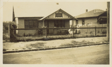
Photograph - 8 Kellett Grove, North Kew, 1929
... 8 Kellett Grove, North Kew......Houses -- Kellett Grove -- Kew (Vic.)...Development beyond this point (ie Kellett Grove) was limited by the City of Kew's planning regulations. ...Small sepia snapshot taken of the front of 8 Kellett Grove, in what was then known as North Kew. ...Verso: 8 KELLETT GROVE / NORTH KEW / 1929 / 41...8 Kellett Grove, Kew, Victoria, Australia...Photograph 8 Kellett Grove, North Kew ...North Kew, now divided between Kew and Kew East, bordered the Yarra River. As such, it was a region subject to flooding in the Yarra Valley. Development beyond this point (ie Kellett Grove) was limited by the City of Kew's planning regulations. Prior to urban development, the area since European settlement and the first land sales in the district in the 1840s, had been used for dairy farming. Small sepia snapshot taken of the front of 8 Kellett Grove, in what was then known as North Kew. Verso: 8 KELLETT GROVE / NORTH KEW / 1929 / 418 kellett gove -- north kew, californian bungalows, houses -- kellett grove -- kew (vic.) -
 Kew Historical Society Inc
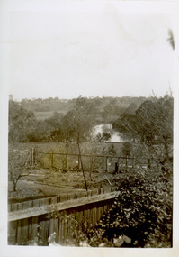
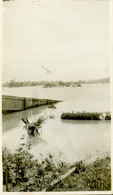
Photograph - View of the Yarra River from 8 Kellett Grove, North Kew, 1948
... View of the Yarra River from 8 Kellett Grove, North Kew......kellett grove -- north kew...Development beyond this point (ie Kellett Grove) was limited by the City of Kew's planning regulations. ...Small sepia snapshot taken from the back yard of a house at 8 Kellett Grove, in what was then known as North Kew. ...8 Kellett Grove, Kew, Victoria, Australia...Photograph View of the Yarra River from 8 Kellett Grove, North Kew ...North Kew, now divided between Kew and Kew East, bordered the Yarra River. As such, it was a region subject to flooding in the Yarra Valley. Development beyond this point (ie Kellett Grove) was limited by the City of Kew's planning regulations. Prior to urban development, the area since European settlement and the first land sales in the district in the 1840s, had been used for dairy farming. The view from the rear of 8 Kellett Grove predates the construction of the Eastern Freeway so provides a rare view of the area before it was built.Small sepia snapshot taken from the back yard of a house at 8 Kellett Grove, in what was then known as North Kew. A tower of the Kew Asylum on the top left of the horizon assist the viewer to recognise that the land to the left of the river is in Kew and Studley Park.Verso: NORTH KEW 1948 / Stamped 51019yarra river -- north kew, kellett grove -- north kew -
 Kew Historical Society Inc
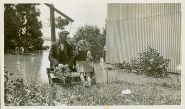
Photograph - Grandfather and granddaughter in the yard of 8 Kellett Grove, Kew, 1934
... Grandfather and granddaughter in the yard of 8 Kellett Grove, Kew...Development beyond this point (ie Kellett Grove) was limited by the City of Kew's planning regulations. ...Small sepia snapshot of a grandfather and granddaughter sitting in the backyard of 8 Kellett Grove, North Kew, with the floodwaters stretching behind them....8 Kellett Grove, Kew, Victoria, Australia...Development beyond this point (ie Kellett Grove) was limited by the City of Kew's planning regulations. ...North Kew, now divided between Kew and Kew East, bordered the Yarra River. As such, it was a region subject to flooding in the Yarra Valley. Development beyond this point (ie Kellett Grove) was limited by the City of Kew's planning regulations. Prior to urban development, the area since European settlement and the first land sales in the district in the 1840s, had been used for dairy farming. Vivid photograph contrasting domestic life and relationships with natural disasters such as the flood of 1934.Small sepia snapshot of a grandfather and granddaughter sitting in the backyard of 8 Kellett Grove, North Kew, with the floodwaters stretching behind them.Verso: GRANDDAD AND I IN BACKYARDyarra river -- north kew, floods -- yarra valley, floods -- north kew, floods -- 1934, natural disasters -- kew, willsmere road -
 Kew Historical Society Inc
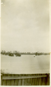
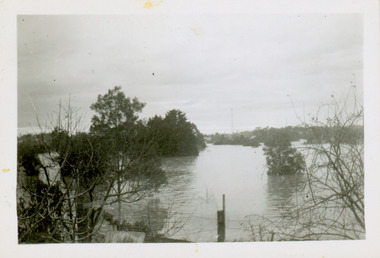
Photograph - Flooding of the Yarra River in North Kew, 1934
... Development beyond this point (ie Kellett Grove) was limited by the City of Kew's planning regulations. ...Small sepia snapshot taken from the back yard of a house at 8 Kellett Grove, in what was then known as North Kew. ...Verso: 8 KELLETT GROVE...8 Kellett Grove, Kew, Victoria, Australia...Development beyond this point (ie Kellett Grove) was limited by the City of Kew's planning regulations. ...North Kew, now divided between Kew and Kew East, bordered the Yarra River. As such, it was a region subject to flooding in the Yarra Valley. Development beyond this point (ie Kellett Grove) was limited by the City of Kew's planning regulations. Prior to urban development, the area since European settlement and the first land sales in the district in the 1840s, had been used for dairy farming. Small sepia snapshot taken from the back yard of a house at 8 Kellett Grove, in what was then known as North Kew. The point of view is from a backyard looking towards Fairfield. Verso: 8 KELLETT GROVEyarra river -- north kew, floods -- yarra valley, floods -- north kew, floods -- 1934, natural disasters -- kew -
 Kew Historical Society Inc
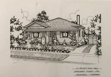
Drawing - Property Illustration, Margaret Picken, 6 Kellett Grove, Kew, 1995
... 6 Kellett Grove, Kew......6 kellett grove -- kew (vic.)...Pen and ink architectural drawing on drafting film of 6 Kellett Grove, Kew by Margaret Picken....The year in which the drawing was created is also a valuable record for house historians, as a number of the properties depicted have either been altered since that date or demolished. artist -- margaret picken 1950- architectural drawings -- houses -- kew (vic.) 6 kellett grove -- kew (vic.) 6 KELLETT GVE., KEW / MARGARET PICKEN '95 / WOODARDS ~ HAWTHORN Pen and ink architectural drawing on drafting film of 6 Kellett Grove, Kew by Margaret Picken. 6 Kellett Grove, Kew Drawing Property Illustration Margaret Picken Woodards (Hawthorn) ...After training as a Cartographic Draftsman within the mining industry, I worked as a property illustrator for real estate firms in the eastern suburbs of Melbourne for 23 years from 1983. I initially photographed houses with a Polaroid camera and made a 'thumbnail' sketch while there. The photos were used to scale off a sketch in pencil and then that sketch was overlaid with drafting film and the 'pen and ink' completed. The pens I used were the Rotring ‘Rapidigraph’ drafting pens. The ink was also made by Rotring (German).The film was ‘Rapidraw’, polyester drafting film, double matte. It takes a very fine line and doesn’t bleed. As well as house sketches, there were often floor plans and site plans ordered. Aerial sketches were ordered when the property needed an overall view. (Margaret Picken, 2020)This drawing is one of a series created by Margaret Picken for a number of real estate agents in Melbourne between 1983 and 2005. Each work is signed and dated by the artist.Gift of Margaret Picken, 2020Pen and ink architectural drawing on drafting film of 6 Kellett Grove, Kew by Margaret Picken.6 KELLETT GVE., KEW / MARGARET PICKEN '95 / WOODARDS ~ HAWTHORNartist -- margaret picken 1950-, architectural drawings -- houses -- kew (vic.), 6 kellett grove -- kew (vic.) -
 Kew Historical Society Inc
Photograph - Flooding of the Yarra River in North Kew, 1934
... Development beyond this point (ie Kellett Grove) was limited by the City of Kew's planning regulations. ...Small sepia snapshot taken from the back yard of a house at 8 Kellett Grove, in what was then known as North Kew. ...Verso: OUR BACKYARD 8 KELLETT GROVE...8 Kellett Grove, Kew, Victoria, Australia...Development beyond this point (ie Kellett Grove) was limited by the City of Kew's planning regulations. ...North Kew, now divided between Kew and Kew East, bordered the Yarra River. As such, it was a region subject to flooding in the Yarra Valley. Development beyond this point (ie Kellett Grove) was limited by the City of Kew's planning regulations. Prior to urban development, the area since European settlement and the first land sales in the district in the 1840s, had been used for dairy farming. Small sepia snapshot taken from the back yard of a house at 8 Kellett Grove, in what was then known as North Kew. The point of view is from a backyard looking towards Fairfield. Verso: OUR BACKYARD 8 KELLETT GROVEyarra river -- north kew, floods -- yarra valley, floods -- north kew, floods -- 1934, natural disasters -- kew -
 Kew Historical Society Inc
Photograph - Flooding of the Yarra River in North Kew, 1934
... Development beyond this point (ie Kellett Grove) was limited by the City of Kew's planning regulations. ...Small sepia snapshot of floodwaters in North Kew, from the rear of 8 Kellett Grove. ...8 Kellett Grove, Kew, Victoria, Australia...Development beyond this point (ie Kellett Grove) was limited by the City of Kew's planning regulations. ...North Kew, now divided between Kew and Kew East, bordered the Yarra River. As such, it was a region subject to flooding in the Yarra Valley. Development beyond this point (ie Kellett Grove) was limited by the City of Kew's planning regulations. Prior to urban development, the area since European settlement and the first land sales in the district in the 1840s, had been used for dairy farming. Small sepia snapshot of floodwaters in North Kew, from the rear of 8 Kellett Grove. Verso: OUR BACKYARD / Stamped 52yarra river -- north kew, floods -- yarra valley, floods -- north kew, floods -- 1934, natural disasters -- kew, willsmere road -
 Kew Historical Society Inc
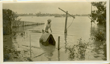
Photograph - Flooding of the Yarra River in North Kew, 1934
... Development beyond this point (ie Kellett Grove) was limited by the City of Kew's planning regulations. ...Small sepia snapshot of the donors grandfather rescuing the family dog's kennel from rising floodwaters at the rear of 8 Kellett Grove, North Kew, ....8 Kellett Grove, Kew, Victoria, Australia...Development beyond this point (ie Kellett Grove) was limited by the City of Kew's planning regulations. ...North Kew, now divided between Kew and Kew East, bordered the Yarra River. As such, it was a region subject to flooding in the Yarra Valley. Development beyond this point (ie Kellett Grove) was limited by the City of Kew's planning regulations. Prior to urban development, the area since European settlement and the first land sales in the district in the 1840s, had been used for dairy farming. Vivid photograph contrasting domestic life and relationships with natural disasters such as the flood of 1934.Small sepia snapshot of the donors grandfather rescuing the family dog's kennel from rising floodwaters at the rear of 8 Kellett Grove, North Kew, .Verso: DAD SECURING NIPPY'S DOG KENNEL / Stamped 6414yarra river -- north kew, floods -- yarra valley, floods -- north kew, floods -- 1934, natural disasters -- kew -
 Kew Historical Society Inc
Photograph - Flooding of the Yarra River in North Kew, 1934
... Development beyond this point (ie Kellett Grove) was limited by the City of Kew's planning regulations. ...Small sepia snapshot of what was then River Avenue, North Kew submerged by floodwaters.The photo was taken in the vicinity of 8 Kellett Grove, North Kew. ...8 Kellett Grove, Kew, Victoria, Australia...Development beyond this point (ie Kellett Grove) was limited by the City of Kew's planning regulations. ...North Kew, now divided between Kew and Kew East, bordered the Yarra River. As such, it was a region subject to flooding in the Yarra Valley. Development beyond this point (ie Kellett Grove) was limited by the City of Kew's planning regulations. Prior to urban development, the area since European settlement and the first land sales in the district in the 1840s, had been used for dairy farming. .Small sepia snapshot of what was then River Avenue, North Kew submerged by floodwaters.The photo was taken in the vicinity of 8 Kellett Grove, North Kew. Verso: TAKEN FROM OUR STREET JUST SEE A BIT OF RYAN'S FENCE / 1934yarra river -- north kew, floods -- yarra valley, floods -- north kew, floods -- 1934, natural disasters -- kew -
 Kew Historical Society Inc
Photograph - Flooding of the Yarra River in North Kew, 1934
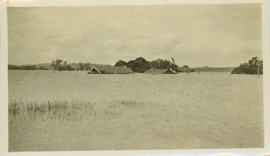
... Development beyond this point (ie Kellett Grove) was limited by the City of Kew's planning regulations. ...Small sepia snapshot of the devastation caused by the 1934 flood.The photo was taken in the vicinity of Kellett Grove, North Kew and includes the roof of Chipperfield's Boathouse as well as other local houses....8 Kellett Grove, Kew, Victoria, Australia...Development beyond this point (ie Kellett Grove) was limited by the City of Kew's planning regulations. ...North Kew, now divided between Kew and Kew East, bordered the Yarra River. As such, it was a region subject to flooding in the Yarra Valley. Development beyond this point (ie Kellett Grove) was limited by the City of Kew's planning regulations. Prior to urban development, the area since European settlement and the first land sales in the district in the 1840s, had been used for dairy farming. .Small sepia snapshot of the devastation caused by the 1934 flood.The photo was taken in the vicinity of Kellett Grove, North Kew and includes the roof of Chipperfield's Boathouse as well as other local houses.Verso: THIS IS CHIPPERFIELD'S BOAT SHEDS & COES & WILLIAMS TAKEN FROM OUR STREET / 1934yarra river -- north kew, floods -- yarra valley, floods -- north kew, floods -- 1934, natural disasters -- kew, chipperfields boathouse -
 Kew Historical Society Inc
Photograph - Flooding of the Yarra River in North Kew, 1934
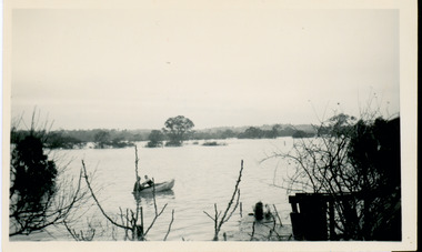
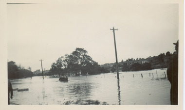
... Development beyond this point (ie Kellett Grove) was limited by the City of Kew's planning regulations. ...Small sepia snapshot of floodwaters taken from near Kellett Grove, in what was then known as North Kew. ...8 Kellett Grove, Kew, Victoria, Australia...Development beyond this point (ie Kellett Grove) was limited by the City of Kew's planning regulations. ...North Kew, now divided between Kew and Kew East, bordered the Yarra River. As such, it was a region subject to flooding in the Yarra Valley. Development beyond this point (ie Kellett Grove) was limited by the City of Kew's planning regulations. Prior to urban development, the area since European settlement and the first land sales in the district in the 1840s, had been used for dairy farming. Small sepia snapshot of floodwaters taken from near Kellett Grove, in what was then known as North Kew. The point of view is from a backyard looking towards Fairfield. In the foreground ar two men in a rowboat.Verso: OUR BACKYARD / Stamped 3 163yarra river -- north kew, floods -- yarra valley, floods -- north kew, floods -- 1934, natural disasters -- kew -
 Kew Historical Society Inc
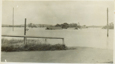
Photograph - Submerged houses in River Avenue, North Kew, 1934
... Development beyond this point (ie Kellett Grove) was limited by the City of Kew's planning regulations. ...The view is presumably from near Kellett Grove looking north towards Fairfield....8 Kellett Grove, Kew, Victoria, Australia...Development beyond this point (ie Kellett Grove) was limited by the City of Kew's planning regulations. ...North Kew, now divided between Kew and Kew East, bordered the Yarra River. As such, it was a region subject to flooding in the Yarra Valley. Development beyond this point (ie Kellett Grove) was limited by the City of Kew's planning regulations. Prior to urban development, the area since European settlement and the first land sales in the district in the 1840s, had been used for dairy farming. Vivid photograph contrasting domestic life and relationships with natural disasters such as the flood of 1934.Small sepia snapshot of two submerged houses belonging to local families in River Avenue, North Kew, during the 1934 floods. The view is presumably from near Kellett Grove looking north towards Fairfield.Verso: COES & HYATTS ROOF / RIVER AVENUE / Stamped: 6414yarra river -- north kew, floods -- yarra valley, floods -- north kew, floods -- 1934, natural disasters -- kew -
 Kew Historical Society Inc
Photograph - Flooding of the Yarra River in North Kew, 1934
... Development beyond this point (ie Kellett Grove) was limited by the City of Kew's planning regulations. ...Small sepia snapshot taken from the back yard of a house at 8 Kellett Grove, in what was then known as North Kew. ...8 Kellett Grove, Kew, Victoria, Australia...Development beyond this point (ie Kellett Grove) was limited by the City of Kew's planning regulations. ...North Kew, now divided between Kew and Kew East, bordered the Yarra River. As such, it was a region subject to flooding in the Yarra Valley. Development beyond this point (ie Kellett Grove) was limited by the City of Kew's planning regulations. Prior to urban development, the area since European settlement and the first land sales in the district in the 1840s, had been used for dairy farming. Small sepia snapshot taken from the back yard of a house at 8 Kellett Grove, in what was then known as North Kew. The point of view is from a backyard looking towards Fairfield. Floodwaters have submerged the fence and a clothes line. Verso: BACKYARD NTH. KEWyarra river -- north kew, floods -- yarra valley, floods -- north kew, floods -- 1934, natural disasters -- kew -
 Kew Historical Society Inc
Photograph - Flooding of the Yarra River in North Kew, 1934
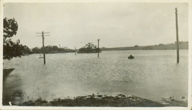
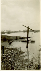
... Development beyond this point (ie Kellett Grove) was limited by the City of Kew's planning regulations. ...Small sepia snapshot taken from the river ramp of a house at 8 Kellett Grove, in what was then known as North Kew. ...8 Kellett Grove, Kew, Victoria, Australia...Development beyond this point (ie Kellett Grove) was limited by the City of Kew's planning regulations. ...North Kew, now divided between Kew and Kew East, bordered the Yarra River. As such, it was a region subject to flooding in the Yarra Valley. Development beyond this point (ie Kellett Grove) was limited by the City of Kew's planning regulations. Prior to urban development, the area since European settlement and the first land sales in the district in the 1840s, had been used for dairy farming. Small sepia snapshot taken from the river ramp of a house at 8 Kellett Grove, in what was then known as North Kew. The point of view is from a backyard looking towards Fairfield. Beyond the fence line are two almost submerged houses. A number of people are in a motor driven boat midstream. Fairfield at this period, (ie 1934) was noted for its limited river side development. Verso: 2/12/34 / TAKEN FROM OUR RAMPyarra river -- north kew, floods -- yarra valley, floods -- north kew, floods -- 1929, floods -- 1934, natural disasters -- kew -
 Kew Historical Society Inc
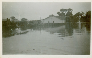
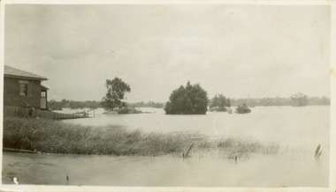
Collection, Floods in North Kew (Series), 1929–1934
... Many of the photos were taken from the rear of 8 Kellett Grove; a house still extant in 2023...8 Kellett Grove, Kew, Victoria, Australia...Many of the photos were taken from the rear of 8 Kellett Grove; a house still extant in 2023 Floods in North Kew (Series) Collection ...Flooding of the Yarra Valley, including that section of the Yarra bordering Kew and Kew East in the north and west of the municipality, was a regular occurrence. Extreme flood events of the Yarra River are recorded to have occurred in 1891, 1901, 1916, 1923 and 1934. The Municipality of Kew's response to these floods was to enact planning decisions restricting residential development in flood prone areas following the floods of 1916, 1921 and 1934. While floods continued after the development of the Upper Yarra Reservoir (construction 1948-57), the regularity and extent of these inundations diminished. Natural disasters had an impact on the development and settlement of Melbourne and its suburbs. Flooding in the Melbourne region was a regular event in the nineteenth and for most of the twentieth centuries. Changes in the impact of natural disasters could occur due to a number of factors. This collection of small snapshots, mostly taken from Kellett Grove in North Kew, provide provenanced evidence of flooding in the area before the development of the unnatural flood barrier that is the Eastern Freeway.Collection of 16 monochrome photographs, annotated on verso by different hands, of the flooding of the River Yarra in North Kew in the third and fourth decades of the twentieth century [1920s & 1930s]. Individual photos include the dates of different floods. Many of the photos were taken from the rear of 8 Kellett Grove; a house still extant in 2023yarra river -- north kew, floods -- yarra valley, floods -- north kew, floods -- 1929, floods -- 1934, natural disasters -- kew -
 Kew Historical Society Inc
Photograph - Flooding of the Yarra Valley at Kew, 1974
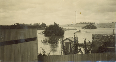
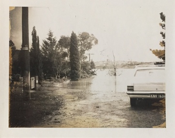
... ...kellett grove...The photograph is taken from 43 Kellett Grove....The photograph is taken from 43 Kellett Grove. Photograph Flooding of the Yarra Valley at Kew ...Flooding of the Yarra Valley, including that section of the Yarra bordering Kew and Kew East in the north and west of the municipality, was a regular occurrence. Extreme flood events of the Yarra River are recorded to have occurred in 1891, 1901, 1916, 1923 and 1934. The Municipality of Kew's response to these floods was to enact planning decisions restricting residential development in flood prone areas following the floods of 1916, 1921 and 1934. While floods continued after the development of the Upper Yarra Reservoir (construction 1948-57), the regularity and extent of these inundations diminished. During the nineteenth century, the land abutting the south side of the Yarra in Kew was devoted to dairy farming. In the twentieth century, before and after the construction of the Eastern Freeway, much of this low-lying area was used as golf courses and public parks.Late example of the capacity of the Yarra Valley at Kew to flood, even though drainage works and the Upper Yarra Reservoir had reduced their regularity.Original black and white print photograph of the low-lying land at East Kew under floodwater on 16 May 1974. The photograph is taken from 43 Kellett Grove.Annotation verso: "Kellett Gve No.43 / Flood Level / 16 May 1974 11.40am"floods, yarra river, kellett grove -
 Kew Historical Society Inc
Photograph - Flooding of the Yarra River in North Kew, 1934
... Development beyond this point (ie Kellett Grove) was limited by the City of Kew's planning regulations. ...8 Kellett Grove, Kew, Victoria, Australia...Development beyond this point (ie Kellett Grove) was limited by the City of Kew's planning regulations. ...North Kew, now divided between Kew and Kew East, bordered the Yarra River. As such, it was a region subject to flooding in the Yarra Valley. Development beyond this point (ie Kellett Grove) was limited by the City of Kew's planning regulations. Prior to urban development, the area since European settlement and the first land sales in the district in the 1840s, had been used for dairy farming. Small sepia snapshot of floodwaters taken from near Willsmere Road, in what was then known as North Kew. The point of view is looking towards Fairfield. In the foreground are two figures viewing a group in a rowboat in the middle of the flooded river. Semi-submerged street lighting indicates that entire streets had been. overwhelmed by the flood waters. Verso: WILLSMERE ROAD NORTH KEW / Stamped 3 163yarra river -- north kew, floods -- yarra valley, floods -- north kew, floods -- 1934, natural disasters -- kew, willsmere road -
 Kew Historical Society Inc
Photograph - Flooding of the Yarra River in North Kew, 1934
... Development beyond this point (ie Kellett Grove) was limited by the City of Kew's planning regulations. ...8 Kellett Grove, Kew, Victoria, Australia...Development beyond this point (ie Kellett Grove) was limited by the City of Kew's planning regulations. ...North Kew, now divided between Kew and Kew East, bordered the Yarra River. As such, it was a region subject to flooding in the Yarra Valley. Development beyond this point (ie Kellett Grove) was limited by the City of Kew's planning regulations. Prior to urban development, the area since European settlement and the first land sales in the district in the 1840s, had been used for dairy farming. Small sepia snapshot of floodwaters in North Kew. The point of view is of two houses belonging to local families that were surrounded by floodwater. Verso: HYATTS HOUSE / WILLSMERE ROAD / Stamped 3 163yarra river -- north kew, floods -- yarra valley, floods -- north kew, floods -- 1934, natural disasters -- kew, willsmere road -
 Kew Historical Society Inc
Photograph - Flooding of the Yarra River in North Kew, 1934
... Development beyond this point (ie Kellett Grove) was limited by the City of Kew's planning regulations. ...8 Kellett Grove, Kew, Victoria, Australia...Development beyond this point (ie Kellett Grove) was limited by the City of Kew's planning regulations. ...North Kew, now divided between Kew and Kew East, bordered the Yarra River. As such, it was a region subject to flooding in the Yarra Valley. Development beyond this point (ie Kellett Grove) was limited by the City of Kew's planning regulations. Prior to urban development, the area since European settlement and the first land sales in the district in the 1840s, had been used for dairy farming. .Small sepia snapshot of a local family's house in what was then River Avenue, North Kew being surrounded by floodwaters.Verso: THE SIDE OF RYANSyarra river -- north kew, floods -- yarra valley, floods -- north kew, floods -- 1934, natural disasters -- kew -
 Kew Historical Society Inc
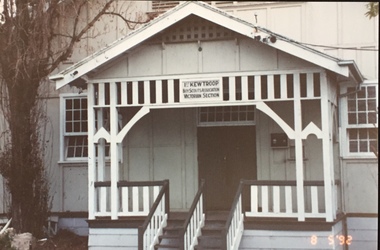
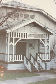
Photograph - 1st Kew Scout Hall, Disraeli Street, 1992
... Still operating (in 2020) from their new Scout Hall on the corner of Kilby Road and Kellett Grove, Kew....Re-established Cr Kilby Rd & Kellett Grove. Nth Kew .."...Re-established Cr Kilby Rd & Kellett Grove. Nth Kew .." Original colour positive photograph of the 1st Kew Scout Troop's single-storey wooden hall in Disraeli Street, Kew, prior to the building's demolition and the relocation of the troop to a new site. ...The 1st Kew Scouts was one of the first Scout Troops in Victoria, being formed in 1909. From 1927 they met in a magnificent Scout Hall in Disraeli Street, Kew until it was demolished in 1993. Still operating (in 2020) from their new Scout Hall on the corner of Kilby Road and Kellett Grove, Kew.Original colour positive photograph of the 1st Kew Scout Troop's single-storey wooden hall in Disraeli Street, Kew, prior to the building's demolition and the relocation of the troop to a new site."1st Kew Scout Hall / Cr Disraeli and Childers St North Kew. Demolished ... Re-established Cr Kilby Rd & Kellett Grove. Nth Kew .."scout troops -- kew (vic.), 1st kew scouts, scout halls -- kew (vic.), scout halls -- melbourne (vic.), boy scouts -
 Kew Historical Society Inc
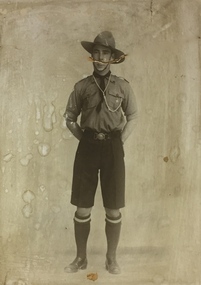
Photograph, 1st Kew Scout Master, circa 1920, c.1920
... Still operating (in 2020) from their new Scout Hall on the corner of Kilby Road and Kellett Grove, Kew....Still operating (in 2020) from their new Scout Hall on the corner of Kilby Road and Kellett Grove, Kew. 1st kew scouts scout master 1920s scout master in uniform 1920s Large sepia photograph of a 1st Kew Scout in uniform. ...The 1st Kew Scouts was one of the first Scout Troops in Victoria, being formed in 1909. From 1927 they met in a magnificent Scout Hall in Disraeli Street, Kew until it was demolished in 1993. Still operating (in 2020) from their new Scout Hall on the corner of Kilby Road and Kellett Grove, Kew.Large sepia photograph of a 1st Kew Scout in uniform. Given that it is a large-sized studio photograph that had been framed and kept for decades, it is likely to be one of the founders of the Scout Troop, perhaps Captain Peowrie. Like many of the early Scout Troops, a man with a military background initially led 1st Kew. Having joined the Scout Troop in 1911 or early 1912, Captain Peowrie went on to serve in the Army during the First World War, rejoining the Scout Troop at war’s end. He went on to be the Scout Leader and later Group Leader up until 1930, whilst also serving as acting District Commissioner for Kew and Deputy Chief Commissioner of Victoria.1st kew scouts, scout master 1920s, scout master in uniform 1920s -
 Kew Historical Society Inc
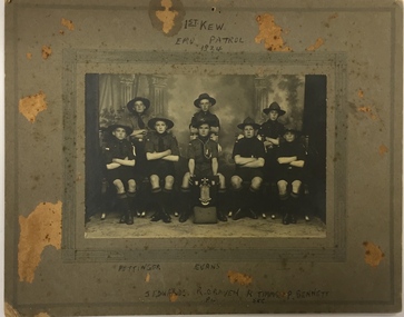
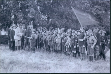
Photograph, 1st Kew Scout Group, 1st Kew Emu Patrol, 1924, 1924
... Still operating (in 2020) from their new Scout Hall on the corner of Kilby Road and Kellett Grove, Kew....Still operating (in 2020) from their new Scout Hall on the corner of Kilby Road and Kellett Grove, Kew. scouts - kew, 1st kew scouts kew fire brigade - walton street Back row left and centre: "Pettinger, Evans" Front row left to right: "J. ...The 1st Kew Scouts was one of the first Scout Troops in Victoria, being formed in 1909. From 1927 they met in a magnificent Scout Hall in Disraeli Street, Kew until it was demolished in 1993. Still operating (in 2020) from their new Scout Hall on the corner of Kilby Road and Kellett Grove, Kew.A Scout Troop is divided into smaller teams called ‘patrols’. At this time the Scout in charge of a patrol was called a patrol leader (‘PL’) and his assistant a ‘second’ (‘Sec’). Each patrol of boys would chose a patrol name, often an Australian animal or bird. Other 1st Kew patrols called themselves the Kookaburra Patrol, the Kangaroo Patrol and so forth. The shield the Emu patrol is proudly displaying is possibly the trophy for being the ‘Champion Victorian Patrol’. Some of the Scouts pictured are identified on the mount of the photograph.Back row left and centre: "Pettinger, Evans" Front row left to right: "J. Edwards, R Craven [PL], R.T. Timms [Sec], P. Bennett scouts - kew, 1st kew scouts, kew fire brigade - walton street -
 Kew Historical Society Inc
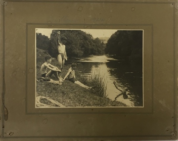
Photograph, Edwin Anderson, 1st Kew Scouts, Water Rescue Training, 1924
... Still operating (in 2020) from their new Scout Hall on the corner of Kilby Road and Kellett Grove, Kew....Still operating (in 2020) from their new Scout Hall on the corner of Kilby Road and Kellett Grove, Kew. scouts - kew, 1st kew scouts yarra river, bulleen water rescue training 1924 On front: 1924. ...The 1st Kew Scouts was one of the first Scout Troops in Victoria, being formed in 1909. From 1927 they met in a magnificent Scout Hall in Disraeli Street, Kew until it was demolished in 1993. Still operating (in 2020) from their new Scout Hall on the corner of Kilby Road and Kellett Grove, Kew.1st Kew Scouts undertaking water rescue training at Bulleen. The photograph was most likely taken while the Scouts were camping beside the river one summer, with the programs generally including not only fun and games but also varying training activities. At the time many locals swam in the river. 1924 was well before the construction of major water storage dams and urbanisation of the upper reaches of the Yarra River, which significantly reduced downstream flows and water quality. These days, the Scouts tend to raft and canoe in the Yarra, rather than swim. On front: 1924. On reverse: photographer's stampscouts - kew, 1st kew scouts, yarra river, bulleen, water rescue training 1924 -
 Kew Historical Society Inc
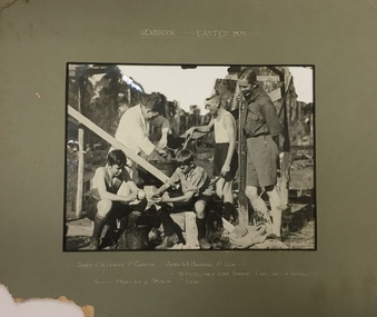
Photograph, 1st Kew Scout Group, 1st Kew Scouts - Gembrook, Easter 1928, 1928
... Still operating (in 2020) from their new Scout Hall on the corner of Kilby Road and Kellett Grove, Kew....Still operating (in 2020) from their new Scout Hall on the corner of Kilby Road and Kellett Grove, Kew. scouts - kew, 1st kew scouts lord somers - governor of victoria scout camp Front: "Gembrook, Easter, 1928 / Rover C.H. ...The 1st Kew Scouts was one of the first Scout Troops in Victoria, being formed in 1909. From 1927 they met in a magnificent Scout Hall in Disraeli Street, Kew until it was demolished in 1993. Still operating (in 2020) from their new Scout Hall on the corner of Kilby Road and Kellett Grove, Kew.1st Kew Scouts with the Governor of Victoria and Chief Scout, Lord Somers. For many years Victorian Scouts participated in a competition camp at the Gilwell Park Scout Camp at Gembrook. The Governor of Victoria has traditionally taken on the honorary role of Victorian Chief Scout and would have been visiting the camp to encourage the Scouts. The names of the Scouts featured in the photograph are inscribed on the mount and include two Rovers, who would have been acting as Scout Leaders on the camp, and two Scouts (who are peeling some spuds for dinner).Front: "Gembrook, Easter, 1928 / Rover C.H. Fraser 1st Croxton, Rover A.A. Drohan 1st Kew / His Excellency Lord Somers Chief Scout of Victoria / Scouts Whelan & Sturdy 1st Kew"scouts - kew, 1st kew scouts, lord somers - governor of victoria, scout camp -
 Kew Historical Society Inc
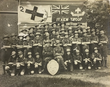
Photograph, 1st Kew Scout Troop with the Cohen Shield, c.1922
... Still operating (in 2020) from their new Scout Hall on the corner of Kilby Road and Kellett Grove, Kew....Still operating (in 2020) from their new Scout Hall on the corner of Kilby Road and Kellett Grove, Kew. cohen shield 1st kew scout troop kew - scouts 1st Kew Troop Large group photo, mounted on card, of 1st Kew Scouts in uniform. ...The 1st Kew Scouts was one of the first Scout Troops in Victoria, being formed in 1909. From 1927 they met in a magnificent Scout Hall in Disraeli Street, Kew until it was demolished in 1993. Still operating (in 2020) from their new Scout Hall on the corner of Kilby Road and Kellett Grove, Kew.Large group photo, mounted on card, of 1st Kew Scouts in uniform. The group of thirty-seven Scouts and two leaders (probably R.J. Poewrie SM and R. Wall ASM) are posed with a shield, likely to be the ‘Cohen Shield’, awarded at a statewide Scoutcraft competition for ‘Champion Troop of Victoria’. This was won by 1st Kew in 1922. The building in the photo is not the Disraeli Street Hall, which was a weatherboard construction.1st Kew Troop cohen shield, 1st kew scout troop, kew - scouts -
 Kew Historical Society Inc
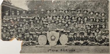
Photograph, 1st Kew B.S.A., 1926, 1926
... Still operating (in 2020) from their new Scout Hall on the corner of Kilby Road and Kellett Grove, Kew....Still operating (in 2020) from their new Scout Hall on the corner of Kilby Road and Kellett Grove, Kew. boy scouts (kew) cubs (kew) scouts (kew) Inscription front: "1st Kew B.S.A. 1926". ...The 1st Kew Scouts was one of the first Scout Troops in Victoria, being formed in 1909. From 1927 they met in a magnificent Scout Hall in Disraeli Street, Kew until it was demolished in 1993. Still operating (in 2020) from their new Scout Hall on the corner of Kilby Road and Kellett Grove, Kew.1st Kew 'Scout Group', showing cubs (wearing the caps in the front rows) as well as scouts and their leaders (wearing hats) in 1926.Inscription front: "1st Kew B.S.A. 1926". Reverse: " KH-286. Donated by Mr Heward".boy scouts (kew), cubs (kew), scouts (kew) -
 Kew Historical Society Inc
Photograph - Presentation of Badges
... Still operating (in 2020) from their new Scout Hall on the corner of Kilby Road and Kellett Grove, Kew....Still operating (in 2020) from their new Scout Hall on the corner of Kilby Road and Kellett Grove, Kew. boys scouts scouting awards 1st kew scouts On reverse of original: "Charlie Eddie [Holmes] being presented with badges by a Stockport gentleman. ...The 1st Kew Scouts was one of the first Scout Troops in Victoria, being formed in 1909. From 1927 they met in a magnificent Scout Hall in Disraeli Street, Kew until it was demolished in 1993. Still operating (in 2020) from their new Scout Hall on the corner of Kilby Road and Kellett Grove, Kew.Print copy of a real photo postcard showing awarding of badges to C.E. Holmes. Charles Edward Hulme was born in Stockport on 4/1/1897. He moved with his family to Ivanhoe in 1912. His obituary was included in The Victorian Scout (June 1963). The copy of the photo was donated by his daughter.On reverse of original: "Charlie Eddie [Holmes] being presented with badges by a Stockport gentleman. Mr Wears, Chief Scout Commissioner of Victoria"boys scouts, scouting awards, 1st kew scouts -
 Kew Historical Society Inc
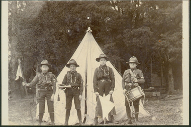
Photograph - Scouts in front of Bell Tent
... Still operating (in 2020) from their new Scout Hall on the corner of Kilby Road and Kellett Grove, Kew....Still operating (in 2020) from their new Scout Hall on the corner of Kilby Road and Kellett Grove, Kew. boys scouts scouting awards 1st kew scouts c e holmes Print copy of a photograph showing four members of the 1st Kew Scouts in front of a Bell Tent. ...The 1st Kew Scouts was one of the first Scout Troops in Victoria, being formed in 1909. From 1927 they met in a magnificent Scout Hall in Disraeli Street, Kew until it was demolished in 1993. Still operating (in 2020) from their new Scout Hall on the corner of Kilby Road and Kellett Grove, Kew.Print copy of a photograph showing four members of the 1st Kew Scouts in front of a Bell Tent. C.E. Holmes is the scout holding the flag at left.boys scouts, scouting awards, 1st kew scouts, c e holmes