Showing 78 items matching "kew railway station"
-
 Kew Historical Society Inc
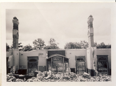
Photograph - Kew Railway Station, Eva Grant, 1959
... Kew Railway Station...kew railway station...Small black and white photograph of the Kew Railway Station..."THE LAST PHASE. JAN 1959. KEW RAILWAY STATION"... and provenance. kew railway station "THE LAST PHASE. JAN 1959. KEW ...Eva Grant's three photograph albums, from which this individual photograph has been taken, contain important images of historic buildings in Kew, Victoria and Australia during the 1950s to the 1970s. The annotations in the album establish their date and provenance. Small black and white photograph of the Kew Railway Station in 1959. The photograph was taken by Kew Historical Society member Ms Eva Grant and placed in one of her scrapbooks (Historic Buildings, Kew, 1958-78). The photograph is from page 2."THE LAST PHASE. JAN 1959. KEW RAILWAY STATION"kew railway station -
 Kew Historical Society Inc
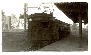
Photograph - Kew Railway Station, May 1950
... Kew Railway Station, May 1950...Kew Railway Station...Small black and white snapshot of Kew Railway Station inMay..."Kew Railway Station, May 1950"... Branch LIne Kew Railway Station "Kew Railway Station, May 1950 ...The Kew railway was opened in 1887, and diverged from the main (Box Hill–Lilydale) line about half-way between Hawthorn and Glenferrie. From the point of divergence the line was slightly less than one mile long, and it had only one intermediate station — Barker. There were four road over-bridges and two level crossings, including one over the busy Barkers Road. The line supported a passenger and goods service, and was electrified in December 1922, at the same time as the main line to Box Hill. There were a number of peak hour services which ran from Flinders Street station (Melbourne) to Kew, but in 1938 all but one of these were diverted to the Ashburton line, where traffic was growing. This had an adverse effect on Kew traffic, as passengers from Kew needed to cross over a footbridge at Hawthorn to change trains, and the main line trains were usually already crowded by the time they reached Hawthorn. At about the same time the off-peak trains were replaced by road buses. In 1952 all passenger trains were withdrawn, but the road bus service continued for many years. Goods trains were finally withdrawn in 1957, and the railway was dismantled in 1958-59. (Source: Frank Stamford, 'The Hawthorn - Kew Railway')Small black and white snapshot of Kew Railway Station inMay 1950. The photograph, one of 12, is part of a larger album of newspaper clippings, timetables, tickets and photos relating to the Kew Railway Line, taken and compiled by Lachlan Richardson, while a resident of Kew. The album dates from the 1950s. The album is part of a larger subject file on the Kew Line, compiled over time by members of the Kew Historical Society."Kew Railway Station, May 1950"kew railway line, transport -- railways -- kew (vic.), kew branch line, kew railway station -
 Kew Historical Society Inc
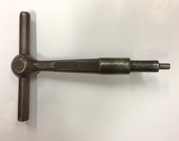
Equipment, Victorian Railways, 'A' Pattern Annett Key : Kew Railway Station, 20th Century
... 'A' Pattern Annett Key : Kew Railway Station...kew railway station - denmark street - kew (vic)...Kew Railway Station was the second railway station...'A' pattern Annett Key, used at the Kew Railway Station... Railway Station was the second railway station on the Kew 'Spur ...Kew Railway Station was the second railway station on the Kew 'Spur' Line in Melbourne. The key unlocked signals equipment at the Station. The key was donated by Harry Jackson in 2019 during an exhibition at the Kew Court House on railway history in Kew.This piece of railway equipment is a rare oiece of railway memorabilia.'A' pattern Annett Key, used at the Kew Railway Station with signals equipment.KEWkew railway station - denmark street - kew (vic), annett keys -
 Kew Historical Society Inc
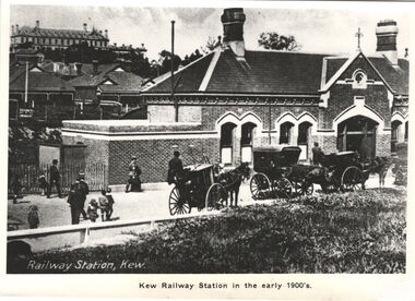
Print, Kew Railway Station in the early 1900s
... Kew Railway Station in the early 1900s...kew railway station...Kew Railway Station (1887-1959). ‘Kew Railway Station... of an early 20th century postcard depicting the Kew Railway Station.... Railway Station (1887-1959). ‘Kew Railway Station’ in Denmark ...Kew Railway Station (1887-1959). ‘Kew Railway Station’ in Denmark Street was the terminus of the Kew Line, which extended from Hawthorn Station to just south of Wellington Street. The Station opened on 19 December 1887 after a prolonged campaign for a railway by the people of Kew. Due to a decline in patronage, the passenger service ceased operations in August 1952. While a freight service continued for another five years, the line and station were officially closed on 13 May 1957. Subsequently demolished in 1959, the headquarters of VicRoads (formerly Country Roads Board) now stands on the former Station site.This work forms part of the collection assembled by the historian Dorothy Rogers, that was donated to the Kew Historical Society by her son John Rogers in 2015. The manuscripts, photographs, maps, and documents were sourced by her from both family and local collections or produced as references for her print publications. Many were directly used by Rogers in writing ‘Lovely Old Homes of Kew’ (1961) and 'A History of Kew' (1973), or the numerous articles on local history that she produced for suburban newspapers. Most of the photographs in the collection include detailed annotations in her hand. The Rogers Collection provides a comprehensive insight into the working habits of a historian in the 1960s and 1970s. Together it forms the largest privately-donated collection within the archives of the Kew Historical Society.A photographic copy of a book plate from 'Kew's Civic Century' (1960) by W.D. Vaughan. The book plate was itself a copy of an early 20th century postcard depicting the Kew Railway Station."Railway opened 1887 - Then as photo states"kew railway station, dorothy rogers, country roads board, vicroads -
 Kew Historical Society Inc
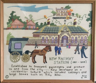
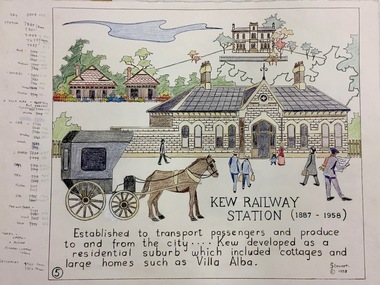
Textile - Bicentennial tapestry, 5. Kew Railway Station (1887-1958), 1988
... 5. Kew Railway Station (1887-1958) ...kew railway station...5. Kew Railway Station (1887-1958). A framed embroidery...Inscription: "KEW RAILWAY STATION (1887-1958). Established... Bicentennial kew railway station Inscription: "KEW RAILWAY STATION ...This is one of eight embroidered panels, completed during the 1988 Australian Bi-Centennial, and carried out under the auspices of City of Kew Council and the Kew Historical Society. Nearly 600 residents, including many children, participated in their production by adding a few or more stitches. A book records their names and the panels upon which they worked. Artist: Joy Stewart / Co-ordinator: Dorothy Benyei.5. Kew Railway Station (1887-1958). A framed embroidery created by adults and children of the City of Kew as a Bicentennial project, based on a design by the artist Joy Stewart. Other completed embroideries created in the project are/were displayed in the Kew Library. Inscription: "KEW RAILWAY STATION (1887-1958). Established to transport passengers and produce too and from the city ... Kew developed as a residential suburb which included cottages and large homes such as Villa Alba". Embroidered signature of the artist "(c) JStewart, 1988"bicentennial project (kew), joy stewart, australian bicentennial, kew railway station -
 Kew Historical Society Inc
Photograph - Kew Railway Station, 1951
... Kew Railway Station, 1951...Kew Railway Station...Small black and white snapshot of Kew Railway Station... Branch LIne Kew Railway Station "Kew Station / 14/51 / 22/4/51 F5 ...The Kew railway was opened in 1887, and diverged from the main (Box Hill–Lilydale) line about half-way between Hawthorn and Glenferrie. From the point of divergence the line was slightly less than one mile long, and it had only one intermediate station — Barker. There were four road over-bridges and two level crossings, including one over the busy Barkers Road. The line supported a passenger and goods service, and was electrified in December 1922, at the same time as the main line to Box Hill. There were a number of peak hour services which ran from Flinders Street station (Melbourne) to Kew, but in 1938 all but one of these were diverted to the Ashburton line, where traffic was growing. This had an adverse effect on Kew traffic, as passengers from Kew needed to cross over a footbridge at Hawthorn to change trains, and the main line trains were usually already crowded by the time they reached Hawthorn. At about the same time the off-peak trains were replaced by road buses. In 1952 all passenger trains were withdrawn, but the road bus service continued for many years. Goods trains were finally withdrawn in 1957, and the railway was dismantled in 1958-59. (Source: Frank Stamford, 'The Hawthorn - Kew Railway')Small black and white snapshot of Kew Railway Station in 1950. The photograph, one of 12, is part of a larger album of newspaper clippings, timetables, tickets and photos relating to the Kew Railway Line, taken and compiled by Lachlan Richardson, while a resident of Kew. The album dates from the 1950s. The album is part of a larger subject file on the Kew Line, compiled over time by members of the Kew Historical Society."Kew Station / 14/51 / 22/4/51 F5"kew railway line, transport -- railways -- kew (vic.), kew branch line, kew railway station -
 Kew Historical Society Inc
Work on paper, Joy Stewart, 5. Kew Railway Station (1887-1958), 1988
... 5. Kew Railway Station (1887-1958)...5. Kew Railway Station (1887-1958). A Handcoloured cartoon...Inscription: "KEW RAILWAY STATION (1887-1958). Established... stewart Inscription: "KEW RAILWAY STATION (1887-1958). Established ...Kew Tapestry The eight panels depict the history of Kew. This was a 1988 Australian Bi-Centennial Project carried out under the auspices of City of Kew Council and the Kew Historical Society Incorporated. Nearly 600 citizens including many children participated in the production by adding a few or more stitches. A book records their names and the panels upon which they worked. Artist: Joy Stewart Co-ordinator: Dorothy BenyeiSydney Joy (Joy) Stewart was born in Melbourne 1925. She studied at Swinburne Technical College Art School from 1941-1945, then the National Gallery Art School 1946-1948. Her career included employment positions as a display artist, designer/painter, gallery assistant, and art teacher. Joy relocated to Cairns in 1981. Solo exhibitions in Melbourne and Cairns, including 'Done By Me' at Cairns Regional Gallery in 1999. Group exhibitions at Cairns Regional Gallery, 'The Fish John West Regrets, 1993' and 'Facets of Life' 1994. Joy Stewart died in Cairns in 2018.5. Kew Railway Station (1887-1958). A Handcoloured cartoon created by the artist Joy Stewart as a template for the fifth of a series of embroidered panels depicting the history of Kew. Wool colour codes at left. Inscription: "KEW RAILWAY STATION (1887-1958). Established to transport passengers and produce too and from the city ... Kew developed as a residential suburb which included cottages an dlarge homes such as Villa Alba". Signed by the artist "(c) JStewart, 1988"bicentennial project (kew), joy stewart -
 Kew Historical Society Inc
Photograph - William John Lamb : Station Master, East Kew Railway Station
... William John Lamb : Station Master, East Kew Railway...East Kew railway station... and Harp Road. Outer circle railway East Kew railway station ...William John Lamb (1878-1958) was born in Ballarat, the second oldest of eight children. His father was born in Scotland and had later migrated to Australia. William Lamb lived in Bright Street, Kew, with his daughter. This was possibly his family home. He died in 1958 aged 80. The Outer Circle Railway on which he worked as station master at East Kew connected the Oakleigh and Fairfield Park Stations. The East Kew Station was on the northern end of Harp Road, Kew, near the junction of High Street and Harp Road.outer circle railway, east kew railway station, station masters - outer circle railway -
 Kew Historical Society Inc
Photograph - Kew Railway Station: Denmark Street entrance, 1952
... Kew Railway Station: Denmark Street entrance, 1952...Kew Railway Station... Branch LIne Kew Railway Station Small black and white snapshot ...The Kew railway was opened in 1887, and diverged from the main (Box Hill–Lilydale) line about half-way between Hawthorn and Glenferrie. From the point of divergence the line was slightly less than one mile long, and it had only one intermediate station — Barker. There were four road over-bridges and two level crossings, including one over the busy Barkers Road. The line supported a passenger and goods service, and was electrified in December 1922, at the same time as the main line to Box Hill. There were a number of peak hour services which ran from Flinders Street station (Melbourne) to Kew, but in 1938 all but one of these were diverted to the Ashburton line, where traffic was growing. This had an adverse effect on Kew traffic, as passengers from Kew needed to cross over a footbridge at Hawthorn to change trains, and the main line trains were usually already crowded by the time they reached Hawthorn. At about the same time the off-peak trains were replaced by road buses. In 1952 all passenger trains were withdrawn, but the road bus service continued for many years. Goods trains were finally withdrawn in 1957, and the railway was dismantled in 1958-59. (Source: Frank Stamford, 'The Hawthorn - Kew Railway')Small black and white snapshot of the entrance to Kew Station from Denmark Street in 1952. The photograph, one of 12, is part of a larger album of newspaper clippings, timetables, tickets and photos relating to the Kew Railway Line, taken and compiled by Lachlan Richardson, while a resident of Kew. The album dates from the 1950s. The album is part of a larger subject file on the Kew Line, compiled over time by members of the Kew Historical Society.kew railway line, transport -- railways -- kew (vic.), kew branch line, kew railway station -
 Kew Historical Society Inc
Postcard - Railway Station, Kew, c.1920
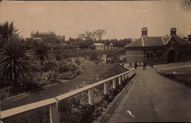
... Railway Station, Kew...kew railway station...Sepia postcard of carriageway to Kew Railway Station... and publications donated to the collection in May 2021. kew railway station ...One of a number of 'real photo' and commercial postcards created by or owned by members of the Christian and Washfold families of Kew. The postcards are part of a larger collection of photographs, postcards and publications donated to the collection in May 2021.Sepia postcard of carriageway to Kew Railway Station. The way is delineated by a white wooden fence and rail. Xavier College (without its chapel) can be seen on the horizon, beyond the garden of the station. kew railway station, xavier college -- kew (vic.), christian-washfold collection -
 Kew Historical Society Inc
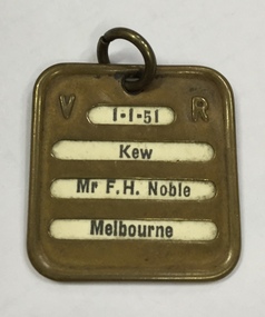
Functional object, Victorian Railways, Mr F.H. Noble : First Class Railway Ticket, Melbourne-Kew, 1951
... kew railway station... to travel from the Kew Railway Station to Melbourne. The Kew Branch... the Kew Railway Station to Melbourne. The Kew Branch Line ceased ...This yearly train ticket was issued to Frederick Noble to travel from the Kew Railway Station to Melbourne. The Kew Branch Line ceased operations as a passenger service in 1952, the year after the ticket was issued. The Kew Railway Station was demolished in 1957. The ticket was donated to the Society by the City of Kew in 1989.Brass VR First Class Rail ticket issued to Frederick Noble. The token is dated 1.1.51. It names the owner as Mr F.H. Noble. Frederick Noble lived in Molesworth Street at this time and worked as a sports journalist on The Age.1-1-51 / Kew / Mr F.H. Noble / Melbourne 1-1-51 / Kew / First Class / Melbournekew railway station, frederick noble --molesworth street -- kew (vic.) -
 Kew Historical Society Inc
Photograph - Kew Station 22/4/51, F3
... kew railway station...Small black and white snapshot of Kew Railway Station... Branch LIne kew railway station Small black and white snapshot ...The Kew railway was opened in 1887, and diverged from the main (Box Hill–Lilydale) line about half-way between Hawthorn and Glenferrie. From the point of divergence the line was slightly less than one mile long, and it had only one intermediate station — Barker. There were four road over-bridges and two level crossings, including one over the busy Barkers Road. The line supported a passenger and goods service, and was electrified in December 1922, at the same time as the main line to Box Hill. There were a number of peak hour services which ran from Flinders Street station (Melbourne) to Kew, but in 1938 all but one of these were diverted to the Ashburton line, where traffic was growing. This had an adverse effect on Kew traffic, as passengers from Kew needed to cross over a footbridge at Hawthorn to change trains, and the main line trains were usually already crowded by the time they reached Hawthorn. At about the same time the off-peak trains were replaced by road buses. In 1952 all passenger trains were withdrawn, but the road bus service continued for many years. Goods trains were finally withdrawn in 1957, and the railway was dismantled in 1958-59. (Source: Frank Stamford, 'The Hawthorn - Kew Railway')Small black and white snapshot of Kew Railway Station, looking south to Barker Station. The photograph, one of 12, is part of a larger album of newspaper clippings, timetables, tickets and photos relating to the Kew Railway Line, taken and compiled by Lachlan Richardson, while a resident of Kew. The album dates from the 1950s. The album is part of a larger subject file on the Kew Line, compiled over time by members of the Kew Historical Society.kew railway line, transport -- railways -- kew (vic.), kew branch line, kew railway station -
 Kew Historical Society Inc
Photograph - The last train at Kew Station, August 1952
... Kew Railway Station... at Kew Railway Station in 1952. The photograph, one of 12... Branch LIne Kew Railway Station "The last train at Kew Station ...The Kew railway was opened in 1887, and diverged from the main (Box Hill–Lilydale) line about half-way between Hawthorn and Glenferrie. From the point of divergence the line was slightly less than one mile long, and it had only one intermediate station — Barker. There were four road over-bridges and two level crossings, including one over the busy Barkers Road. The line supported a passenger and goods service, and was electrified in December 1922, at the same time as the main line to Box Hill. There were a number of peak hour services which ran from Flinders Street station (Melbourne) to Kew, but in 1938 all but one of these were diverted to the Ashburton line, where traffic was growing. This had an adverse effect on Kew traffic, as passengers from Kew needed to cross over a footbridge at Hawthorn to change trains, and the main line trains were usually already crowded by the time they reached Hawthorn. At about the same time the off-peak trains were replaced by road buses. In 1952 all passenger trains were withdrawn, but the road bus service continued for many years. Goods trains were finally withdrawn in 1957, and the railway was dismantled in 1958-59. (Source: Frank Stamford, 'The Hawthorn - Kew Railway')Small black and white snapshot of the last passenger train at Kew Railway Station in 1952. The photograph, one of 12, is part of a larger album of newspaper clippings, timetables, tickets and photos relating to the Kew Railway Line, taken and compiled by Lachlan Richardson, while a resident of Kew. The album dates from the 1950s. The album is part of a larger subject file on the Kew Line, compiled over time by members of the Kew Historical Society."The last train at Kew Station, August 1952"kew railway line, transport -- railways -- kew (vic.), kew branch line, kew railway station -
 Kew Historical Society Inc
Album - Scrapbook, Eva Grant, Historic Buildings, Kew, 1958-78, 1970s
... kew railway station - denmark street - kew (vic)...) Kew Railway Station (1902, 1959) Kew Recreation Hall... railway station - denmark street - kew (vic) recreation hall ...One of three scrapbooks of photographs and newspaper cuttings taken and or collected by Eva Grant, a past member of the Kew Historical Society, which were donated by her niece, Julie Thomson. The albums include many photographs of Kew from the 1950s to the 1970s. Buildings included in the scrapbook include: Billy Hughes' house - 167 Cotham Road Congregational Church - Walpole Street (c.1978) Country Roads Board - Denmark Street (1960) Dorothy Rogers Reserve - Studley Park Road Ellsmere (also Ellesmere/Ellsmore) - Princess Street Field Place - 3 Henty Court Fernhurst - 13 Fernhurst Grove Kew Civic Centre (1959) Kew Junction (1958) Kew Railway Station (1902, 1959) Kew Recreation Hall - Wellington Street (1960) Neama (Hall) - Studley Park Road Southesk (formerly Ordsall) - Cotham Road (c.1960) St Anthony's Home for Babies (formerly Madford) - 43 Wellington Street (c.1976) Studley House - Nolan AvenueThe scrapbook contains historically significant, rare and sometimes unique images of significant heritage buildings in Kew, including their erection and demolition. 11-page scrapbook of photographs and newspaper clippings with annotations by Eva Grant, a past member of the Kew Historical Society. The pages of the album can be viewed in the image carousel above. Based on the text and known dates of demolition of a number of the buildings, the scrapbook was assembled over a twenty year period between c.1958-c.1978.Includes letter from donoreva grant, billy hughes' house - 167 cotham road, congregational church - walpole street - kew, country roads board - denmark street - kew, dorothy rogers reserve - studley park road - kew, field place - 3 henty court - kew (vic), ellsmere (also ellesmere/ellsmore) - princess street - kew, fernhurst - 13 fernhurst grove - kew (vic), kew civic centre - civic drive - kew (vic), kew junction - kew (vic), kew railway station - denmark street - kew (vic), recreation hall - wellington street - kew, neama - hall - studley park road - kew (vic), southesk - ordsall - cotham road- kew (vic), st anthony's home for babies - madford - 43 wellington street (vic), studley house - nolan avenue - kew (vic) -
 Kew Historical Society Inc
Photograph - Farewell to 'Our Lady of Fatima'. Xavier College 22/4/51
... kew railway station... Branch LIne Xavier College kew railway station "Farewell to 'Our ...The Kew railway was opened in 1887, and diverged from the main (Box Hill–Lilydale) line about half-way between Hawthorn and Glenferrie. From the point of divergence the line was slightly less than one mile long, and it had only one intermediate station — Barker. There were four road over-bridges and two level crossings, including one over the busy Barkers Road. The line supported a passenger and goods service, and was electrified in December 1922, at the same time as the main line to Box Hill. There were a number of peak hour services which ran from Flinders Street station (Melbourne) to Kew, but in 1938 all but one of these were diverted to the Ashburton line, where traffic was growing. This had an adverse effect on Kew traffic, as passengers from Kew needed to cross over a footbridge at Hawthorn to change trains, and the main line trains were usually already crowded by the time they reached Hawthorn. At about the same time the off-peak trains were replaced by road buses. In 1952 all passenger trains were withdrawn, but the road bus service continued for many years. Goods trains were finally withdrawn in 1957, and the railway was dismantled in 1958-59. (Source: Frank Stamford, 'The Hawthorn - Kew Railway')Small black and white snapshot of a train leaving Kew Station with the Xavier Chapel on the hill in the background, hence the ironic title provided by the photographer. The photograph, one of 12, is part of a larger album of newspaper clippings, timetables, tickets and photos relating to the Kew Railway Line, taken and compiled by Lachlan Richardson, while a resident of Kew. The album dates from the 1950s. The album is part of a larger subject file on the Kew Line, compiled over time by members of the Kew Historical Society."Farewell to 'Our Lady of Fatima'. Xavier College 22/4/51"kew railway line, transport -- railways -- kew (vic.), kew branch line, xavier college, kew railway station -
 Kew Historical Society Inc
Photograph - The last train at Barker Station, 1952
... Railway Station Kew Branch LIne "Last train at Barker Station / 1 ...The Kew railway was opened in 1887, and diverged from the main (Box Hill–Lilydale) line about half-way between Hawthorn and Glenferrie. From the point of divergence the line was slightly less than one mile long, and it had only one intermediate station — Barker. There were four road over-bridges and two level crossings, including one over the busy Barkers Road. The line supported a passenger and goods service, and was electrified in December 1922, at the same time as the main line to Box Hill. There were a number of peak hour services which ran from Flinders Street station (Melbourne) to Kew, but in 1938 all but one of these were diverted to the Ashburton line, where traffic was growing. This had an adverse effect on Kew traffic, as passengers from Kew needed to cross over a footbridge at Hawthorn to change trains, and the main line trains were usually already crowded by the time they reached Hawthorn. At about the same time the off-peak trains were replaced by road buses. In 1952 all passenger trains were withdrawn, but the road bus service continued for many years. Goods trains were finally withdrawn in 1957, and the railway was dismantled in 1958-59. (Source: Frank Stamford, 'The Hawthorn - Kew Railway')Small black and white snapshot of the last passenger train at Barker Railway Station in 1952. The photograph, one of 12, is part of a larger album of newspaper clippings, timetables, tickets and photos relating to the Kew Railway Line, taken and compiled by Lachlan Richardson, while a resident of Kew. The album dates from the 1950s. The album is part of a larger subject file on the Kew Line, compiled over time by members of the Kew Historical Society."Last train at Barker Station / 1 August 1952"kew railway line, transport -- railways -- kew (vic.), barker railway station, kew branch line -
 Kew Historical Society Inc
Photograph - Barker Station, August 1952
... Railway Station Kew Branch LIne "Barker Station / August 1952 ...The Kew railway was opened in 1887, and diverged from the main (Box Hill–Lilydale) line about half-way between Hawthorn and Glenferrie. From the point of divergence the line was slightly less than one mile long, and it had only one intermediate station — Barker. There were four road over-bridges and two level crossings, including one over the busy Barkers Road. The line supported a passenger and goods service, and was electrified in December 1922, at the same time as the main line to Box Hill. There were a number of peak hour services which ran from Flinders Street station (Melbourne) to Kew, but in 1938 all but one of these were diverted to the Ashburton line, where traffic was growing. This had an adverse effect on Kew traffic, as passengers from Kew needed to cross over a footbridge at Hawthorn to change trains, and the main line trains were usually already crowded by the time they reached Hawthorn. At about the same time the off-peak trains were replaced by road buses. In 1952 all passenger trains were withdrawn, but the road bus service continued for many years. Goods trains were finally withdrawn in 1957, and the railway was dismantled in 1958-59. (Source: Frank Stamford, 'The Hawthorn - Kew Railway')Small black and white snapshot of the last passenger train at Barker Railway Station in 1952. The photograph, one of 12, is part of a larger album of newspaper clippings, timetables, tickets and photos relating to the Kew Railway Line, taken and compiled by Lachlan Richardson, while a resident of Kew. The album dates from the 1950s. The album is part of a larger subject file on the Kew Line, compiled over time by members of the Kew Historical Society."Barker Station / August 1952"kew railway line, transport -- railways -- kew (vic.), barker railway station, kew branch line -
 Kew Historical Society Inc
Photograph - Seven Carriage Train at Barker Station
... Railway Station Kew Branch LIne "Seven Carriage Train at Barker ...The Kew railway was opened in 1887, and diverged from the main (Box Hill–Lilydale) line about half-way between Hawthorn and Glenferrie. From the point of divergence the line was slightly less than one mile long, and it had only one intermediate station — Barker. There were four road over-bridges and two level crossings, including one over the busy Barkers Road. The line supported a passenger and goods service, and was electrified in December 1922, at the same time as the main line to Box Hill. There were a number of peak hour services which ran from Flinders Street station (Melbourne) to Kew, but in 1938 all but one of these were diverted to the Ashburton line, where traffic was growing. This had an adverse effect on Kew traffic, as passengers from Kew needed to cross over a footbridge at Hawthorn to change trains, and the main line trains were usually already crowded by the time they reached Hawthorn. At about the same time the off-peak trains were replaced by road buses. In 1952 all passenger trains were withdrawn, but the road bus service continued for many years. Goods trains were finally withdrawn in 1957, and the railway was dismantled in 1958-59. (Source: Frank Stamford, 'The Hawthorn - Kew Railway')Small black and white snapshot of a seven carriage train approaching Barker Railway Station. The photograph, one of 12, is part of a larger album of newspaper clippings, timetables, tickets and photos relating to the Kew Railway Line, taken and compiled by Lachlan Richardson, while a resident of Kew. The album dates from the 1950s. The album is part of a larger subject file on the Kew Line, compiled over time by members of the Kew Historical Society."Seven Carriage Train at Barker Station"kew railway line, transport -- railways -- kew (vic.), barker railway station, kew branch line -
 Kew Historical Society Inc
Photograph - Kew Branch Line: Looking along cutting towards Barker Station 22/4/51
... Railway Station Kew Branch LIne "Looking along cutting towards ...The Kew railway was opened in 1887, and diverged from the main (Box Hill–Lilydale) line about half-way between Hawthorn and Glenferrie. From the point of divergence the line was slightly less than one mile long, and it had only one intermediate station — Barker. There were four road over-bridges and two level crossings, including one over the busy Barkers Road. The line supported a passenger and goods service, and was electrified in December 1922, at the same time as the main line to Box Hill. There were a number of peak hour services which ran from Flinders Street station (Melbourne) to Kew, but in 1938 all but one of these were diverted to the Ashburton line, where traffic was growing. This had an adverse effect on Kew traffic, as passengers from Kew needed to cross over a footbridge at Hawthorn to change trains, and the main line trains were usually already crowded by the time they reached Hawthorn. At about the same time the off-peak trains were replaced by road buses. In 1952 all passenger trains were withdrawn, but the road bus service continued for many years. Goods trains were finally withdrawn in 1957, and the railway was dismantled in 1958-59. (Source: Frank Stamford, 'The Hawthorn - Kew Railway')Small black and white snapshot looking along cutting towards Barker Station 22/4/51. The photograph, one of 12, is part of a larger album of newspaper clippings, timetables, tickets and photos relating to the Kew Railway Line, taken and compiled by Lachlan Richardson, while a resident of Kew. The album dates from the 1950s. The album is part of a larger subject file on the Kew Line, compiled over time by members of the Kew Historical Society."Looking along cutting towards Barker Station 22/4/51"kew railway line, transport -- railways -- kew (vic.), barker railway station, kew branch line -
 Kew Historical Society Inc
Photograph - Kew Branch Line: Weeds at Kew Station 14/51
... Railway Station Kew Branch LIne Small black and white snapshot ...The Kew railway was opened in 1887, and diverged from the main (Box Hill–Lilydale) line about half-way between Hawthorn and Glenferrie. From the point of divergence the line was slightly less than one mile long, and it had only one intermediate station — Barker. There were four road over-bridges and two level crossings, including one over the busy Barkers Road. The line supported a passenger and goods service, and was electrified in December 1922, at the same time as the main line to Box Hill. There were a number of peak hour services which ran from Flinders Street station (Melbourne) to Kew, but in 1938 all but one of these were diverted to the Ashburton line, where traffic was growing. This had an adverse effect on Kew traffic, as passengers from Kew needed to cross over a footbridge at Hawthorn to change trains, and the main line trains were usually already crowded by the time they reached Hawthorn. At about the same time the off-peak trains were replaced by road buses. In 1952 all passenger trains were withdrawn, but the road bus service continued for many years. Goods trains were finally withdrawn in 1957, and the railway was dismantled in 1958-59. (Source: Frank Stamford, 'The Hawthorn - Kew Railway')Small black and white snapshot of how the Kew Branch Line was allowed to run down. The photograph, one of 12, is part of a larger album of newspaper clippings, timetables, tickets and photos relating to the Kew Railway Line, taken and compiled by Lachlan Richardson, while a resident of Kew. The album dates from the 1950s. The album is part of a larger subject file on the Kew Line, compiled over time by members of the Kew Historical Society.kew railway line, transport -- railways -- kew (vic.), barker railway station, kew branch line -
![Workers, horses and drays in Burwood Road [Hawthorn]](/media/collectors/550653872162f11fb04854aa/items/661f4c86ac7f9cfd1fd6c658/item-media/661f4d6bac7f9cfd1fd722a1/item-fit-380x285.jpg) Kew Historical Society Inc
Kew Historical Society IncPhotograph - Workers, horses and drays in Burwood Road [Hawthorn], E.J. Dower, 1913
... -- Kew (Vic.) Trams -- Kew (Vic.) Hawthorn Railway Station ...One of a series of photographs, taken by Edgar James Dower in the second decade of the twentieth century. Born and raised in Olinda, his family later moved to Surrey Hills. He worked as an adult as a clerk in the city office of the Metropolitan Gas Company, and in his role as a 'collector', he was able to photograph scenes including the construction of tramlines and associated buildings in Kew, Hawthorn, Camberwell and Surrey Hills. Later he established a real estate agency with his brother - the E.J. Dower Real Estate Agency, Dandenong Office.The image is an historically significant record of the development of transport infrastructure which was used to connect Victorians in the first two decades of the twentieth century. This development resulted from increases in population and the consequent extension of Melbourne's suburbs. The photographs, both individually and collectively, richly detail the labour of workers and the tools and machinery used to create and extend Melbourne's tram network in the years preceding and during World War 1.Digital copy of an original mounted photograph depicting construction workers, horses and drays Hawthorn. The intense activity involved collecting materials for transport to the construction site in Cotham Road, Kew. Annotated recto: "Unloading trucks of metal for Kew Electric Tram Line in Cotham Road / At Hawthorn Railway Siding" Annotated verso: "Taken by E.J.D. / 1913"theme --- travelling by tram, theme -- connecting victorians by transport and communications, cotham road -- kew (vic.), trams -- kew (vic.), hawthorn railway station -
 Melbourne Tram Museum
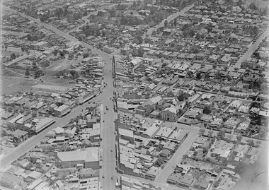
Photograph - Digital Image, Kevin O'Reilly, Kew Junction from the north east, towards the city, c1930's
... the Kew railway station precinct. Has a inbound W class tram... railway station precinct. Has a inbound W class tram picking up ...Image from CD (Compact Diskette for use in computers) - see Reg Item 135. Image titled "Kew Junction' on CD, of looking Kew Junction from the north east, towards the city, shows the Kew railway station precinct. Has a inbound W class tram picking up passengers at the Kew Post Office. A summer day. Possibly late 1920's, early 1930's.trams, tramways, kew, kew junction, kew post office, high st -
 Kew Historical Society Inc
Plan, Melbourne & Metropolitan Board of Works. Borough of Kew Detail Plan No.1579, 1904
... the ‘Kew [Railway] Station’ in Denmark Street and the ‘Recreation... are significant to Kew’s history. These include the ‘Kew [Railway] Station ...The Melbourne and Metropolitan Board of Works (MMBW) plans were produced from the 1890s to the 1950s. They were crucial to the design and development of Melbourne's sewerage and drainage system. The plans, at a scale of 40 feet to 1 inch (1:480), provide a detailed historical record of Melbourne streetscapes and environmental features. Each plan covers one or two street blocks (roughly six streets), showing details of buildings, including garden layouts and ownership boundaries, and features such as laneways, drains, bridges, parks, municipal boundaries and other prominent landmarks as they existed at the time each plan was produced. (Source: State Library of Victoria). This plan forms part of a large group of MMBW plans and maps that was donated to the Society by the Mr Poulter, City Engineer of the City of Kew in 1989. Within this collection, thirty-five hand-coloured plans, backed with linen, are of statewide significance as they include annotations that provide details of construction materials used in buildings in the first decade of the 20th century as well as additional information about land ownership and usage. The copies in the Public Record Office Victoria and the State Library of Victoria are monochrome versions which do not denote building materials so that the maps in this collection are invaluable and unique tools for researchers and heritage consultants. A number of the plans are not held in the collection of the State Library of Victoria so they have the additional attribute of rarity.Original survey plan, issued by the MMBW to a contractor with responsibility for constructing sewers in the area identified on the plan within the Borough of Kew. The plan was at some stage hand-coloured, possibly by the contractor, but more likely by officers working in the Engineering Department of the Borough and later Town, then City of Kew. The hand-coloured sections of buildings on the plan were used to denote masonry or brick constructions (pink), weatherboard constructions (yellow), and public buildings (grey). While MMBW Plan No.1579 does not include many buildings, those that it does show are significant to Kew’s history. These include the ‘Kew [Railway] Station’ in Denmark Street and the ‘Recreation Hall’ and rear courts off Wellington Street. The plan shows the outline of the Recreation Hall, constructed in 1880, at the rear of which is listed a bowling green, two tennis courts, a ‘skittle alley’ and a pavilion. When the Hall was first built, the Kew Cricket Club occupied an adjacent ground, however in 1885 this was acquired by the State Government as the future location of the Kew Railway Station. The Plan also shows a single oval at Xavier College. This oval was completed in 1883. One of the current ovals conforms to this oval’s original shape and position in the school grounds.melbourne and metropolitan board of works, detail plans, maps - borough of kew, mmbw 1579, cartography -
 Kew Historical Society Inc
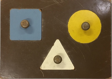
Leisure object, Child's Puzzle : Denmark Street Baby Health Centre, c.1950s
... at the Kew Railway Station for a Baby Health Centre for a term of 21..., the Railway Commissioners agreed to lease a site at the Kew Railway ...In August, 1920, The Kew Town Council decided to establish a Baby Health Centre in Kew. The first Centre was opened in a room in the Town Hall in Walpole Street on 5 November 1920. In May 1939, the Railway Commissioners agreed to lease a site at the Kew Railway Station for a Baby Health Centre for a term of 21 years at 3 pounds per annum. A building, designed by Roland Chipperfield, was erected, and the Centre previously conducted at the Town Hall transferred there. This became known as the Denmark Street Baby Health Centre. (Cr. W.D. Vaughan, Kew’s Civic Century, W.D. Vaughan Pty Ltd., Kew, 1960, pp.96 & 97.)One of a pair of wooden puzzles used in the Denmark Street Baby Health Centre in Kew.denmark street baby health centre - kew (vic), baby health centres - kew (vic), games and puzzles -
 Kew Historical Society Inc
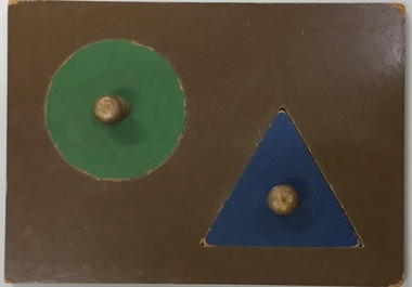
Leisure object, Child's Puzzle : Denmark Street Baby Health Centre, c.1950s
... at the Kew Railway Station for a Baby Health Centre for a term of 21..., the Railway Commissioners agreed to lease a site at the Kew Railway ...In August, 1920, The Kew Town Council decided to establish a Baby Health Centre in Kew. The first Centre was opened in a room in the Town Hall in Walpole Street on 5 November 1920. In May 1939, the Railway Commissioners agreed to lease a site at the Kew Railway Station for a Baby Health Centre for a term of 21 years at 3 pounds per annum. A building, designed by Roland Chipperfield, was erected, and the Centre previously conducted at the Town Hall transferred there. This became known as the Denmark Street Baby Health Centre. (Cr. W.D. Vaughan, Kew’s Civic Century, W.D. Vaughan Pty Ltd., Kew, 1960, pp.96 & 97.)One of a pair of wooden puzzles used in the Denmark Street Baby Health Centre in Kew.denmark street baby health centre - kew (vic), baby health centres - kew (vic), games and puzzles -
 Kew Historical Society Inc
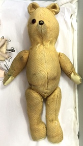
Leisure object, Teddy Bear, 1930-1955
... at the Kew Railway Station for a Baby Health Centre for a term of 21..., the Railway Commissioners agreed to lease a site at the Kew Railway ...In August, 1920, The Kew Town Council decided to establish a Baby Health Centre in Kew. The first Centre was opened in a room in the Town Hall in Walpole Street on 5 November 1920. In May 1939, the Railway Commissioners agreed to lease a site at the Kew Railway Station for a Baby Health Centre for a term of 21 years at 3 pounds per annum. A building, designed by Roland Chipperfield, was erected, and the Centre previously conducted at the Town Hall transferred there. This became known as the Denmark Street Baby Health Centre. (Cr. W.D. Vaughan, Kew’s Civic Century, W.D. Vaughan Pty Ltd., Kew, 1960, pp.96 & 97.)Small teddy bear with only one eye remaining and with a number of repairs. The bear was used by children at the Denmark Street Baby Health Centre in Kew.toys - teddy bears, denmark street baby health centre - kew (vic) -
 Kew Historical Society Inc
Photograph, J F C Farquhar, Wellington Street From High Street, 1891
... by a picket fence, is the Kew Railway Station (demolished 1957..., bordered by a picket fence, is the Kew Railway Station (demolished ...At the beginning of the 1890s, the Kew businessman and Town Councillor, Henry Kellett, commissioned J.F.C. Farquhar to photograph scenes of Kew. These scenes included panoramas as well as pastoral scenes. The resulting set of twelve photographs was assembled in an album, Kew Where We Live, from which customers could select images for purchase.The preamble to the album describes that the photographs used the ‘argentic bromide’ process, now more commonly known as the gelatine silver process. This form of dry plate photography allowed for the negatives to be kept for weeks before processing, hence its value in landscape photography. The resulting images were considered to be finely grained and everlasting. Evidence of the success of Henry Kellett’s venture can be seen today, in that some of the photographs are held in national collections.It is believed that the Kew Historical Society’s copy of the Kellett album is unique and that the photographs in the book were the first copies taken from the original plates. It is the first and most important series of images produced about Kew. The individual images have proved essential in identifying buildings and places of heritage value in the district.Very few of the natural or built features in this panoramic photograph of Wellington Street remain. The open land between High Street South and Denmark Street, then known as O’Shannessy’s Paddock, was to become a residential subdivision at the beginning of the 20th Century. On the far side of Denmark Street, bordered by a picket fence, is the Kew Railway Station (demolished 1957). Further east, the large building with the flagpole is the Kew Recreation Hall (demolished 1960), which was the centre of civic life for almost a century. The building was used for dances, civic functions and exhibitions. A bowling green, tennis courts, and a cricket ground surrounded the Hall. The dominant building in the photograph is Xavier College, founded in 1872 by the Society of Jesus. The first classes for pupils were held in 1878. It is presumed that Farquhar used its roof for two of his bird’s eye views.Wellington Street from High Streetkew illustrated, kew where we live, photographic books, henry kellett -
 Kew Historical Society Inc
Photograph - Country Roads Board and Denmark Street Baby Health Centre, Ron Setford, 1961
... to lease a site at the Kew Railway Station for a Baby Health Centre... at the Kew Railway Station for a Baby Health Centre. The single ...Ron Setford and his wife Grace Setford lived in Tanner Avenue, East Kew, from c.1946 to c.1995. A keen photographer, he recorded the changing face of Kew over a 20 year period. Apart from 30 photographs of built structures and places in Kew dating from 1960 and 1961, 145 of his 35mm colour slides chronicle the development of the Eastern Freeway through the Yarra Valley over a five year period from c.1972 to c.1977. This important collection was donated to the Society by his granddaughter in 2025.This collection of 175 35mm slides is of local and statewide significance, owing to its subject matter, particularly the major development of road transport infrastructure during the 1970s with the construction of the Eastern Freeway. The photographer also took care to annotate and date most of his slides which enable the researcher to pinpoint temporal and spatial locations.A photograph providing a visual contrast of the pre and post-World War II architectural styles of the Denmark Street Baby Health Centre and two of the Country Roads Board office buildings. Each was built on part of the land fronting the Kew branch line. In May 1939, the Railway Commissioners agreed to lease a site at the Kew Railway Station for a Baby Health Centre. The single-storey cream brick building was designed by Roland Chipperfield. The Country Roads Board (1913–83), later renamed VicRoads, transferred its headquarters from the Royal Exhibition Building to Kew in 1961, following the completion of two modernist eight-storey office towers in 1960. The VicRoads buildings were closed in 2024, and there is ongoing debate about what replaces them.Nilron setford, photographs -- kew (vic.) -- 1960s, country roads board, vicroads, denmark street -- kew (vic.), denmark street baby health centre -
 Kew Historical Society Inc
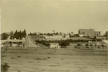
Photograph, J F C Farquhar, Bird's Eye View Looking West, 1891
... Club. Further west is the Kew Railway Station on Denmark Street... Club. Further west is the Kew Railway Station on Denmark Street ...At the beginning of the 1890s, the Kew businessman and Town Councillor, Henry Kellett, commissioned J.F.C. Farquhar to photograph scenes of Kew. These scenes included panoramas as well as pastoral scenes. The resulting set of twelve photographs was assembled in an album, Kew Where We Live, from which customers could select images for purchase.The preamble to the album describes that the photographs used the ‘argentic bromide’ process, now more commonly known as the gelatine silver process. This form of dry plate photography allowed for the negatives to be kept for weeks before processing, hence its value in landscape photography. The resulting images were considered to be finely grained and everlasting. Evidence of the success of Henry Kellett’s venture can be seen today, in that some of the photographs are held in national collections.It is believed that the Kew Historical Society’s copy of the Kellett album is unique and that the photographs in the book were the first copies taken from the original plates. It is the first and most important series of images produced about Kew. The individual images have proved essential in identifying buildings and places of heritage value in the district.Before true aerial photography became possible, photographers such as J.F.C. Farquhar were compelled to shoot their images from the highest vantage point. Here, it is presumed to be the roof of Xavier College, from which the panoramic view extends west towards the rise of Studley Park. The houses in the foreground face the southern end of Gellibrand Street. Wellington Street is at an angle to the camera with the Queen Street intersection on the near right. The wooden building behind the large horse paddock on the other side of Gellibrand Street is the Kew Recreation Hall, built 1888, demolished 1960. It was reputed to have one of the finest dancing floors in or around Melbourne. The Bowling Green at the rear of the Hall belonged to the Kew Bowling Club. Further west is the Kew Railway Station on Denmark Street, opened to the public in 1887. At this period, much of Studley Park was locked up in large landholdings, dominated by large mansions such as ‘Byram’. Bird's Eye View Looking Westkew illustrated, kew where we live, photographic books, henry kellett, denmark street, kew recreation hall, kew bowling club, wellington street -
 Kew Historical Society Inc
Plan - Subdivision Plan, J R Mathers & McMillan, Glenarbor Estate, 1934
... Railway Station and access to shops in Denmark Street. Due to its... proximity of the entrance to the Kew Railway Station and access ...Pru Sanderson, in her groundbreaking ‘City of Kew Urban Conservation Study : Volume 2 - Development History’ (1988), summarised the periods of urban development and subdivisions of land in Kew. The periods that she identified included 1845-1880, 1880-1893, 1893-1921, 1921-1933, 1933-1943, and Post-War Development. These periods were selected as they represented periods of rapid growth or decline in urban development. An obvious starting point for Sanderson’s groupings involved population growth and the associated economic cycles. These cycles also highlighted urban expansion onto land that was predominantly rural, although in other cases it represented the decline and breakup of large estates. A number of the plans in the Kew Historical Society’s collection can also be found in other collections, such as those of the State Library of Victoria and the Boroondara Library Service. A number are however unique to the collection.The Kew Historical Society collection includes almost 100 subdivision plans pertaining to suburbs of the City of Melbourne. Most of these are of Kew, Kew East or Studley Park, although a smaller number are plans of Camberwell, Deepdene, Balwyn and Hawthorn. It is believed that the majority of the plans were gifted to the Society by persons connected with the real estate firm - J. R. Mathers and McMillan, 136 Cotham Road, Kew. The Plans in the collection are rarely in pristine form, being working plans on which the agent would write notes and record lots sold and the prices of these. The subdivision plans are historically significant examples of the growth of urban Melbourne from the beginning of the 20th Century up until the 1980s. A number of the plans are double-sided and often include a photograph on the reverse. A number of the latter are by noted photographers such as J.E. Barnes.The little-known Glenarbor Estate comprised 23 allotments bordering Wellington and Denmark Streets and Fenton Avenue. The auction of the allotments in the Estate was held in the Kew Recreation Hall. The purported advantages to Kew are identified on the plan, such as the close proximity of the entrance to the Kew Railway Station and access to shops in Denmark Street. Due to its location, the subdivision was pitched at commercial as well as residential purchasers. The Estate was to cause a crisis in the Kew Council as a majority of councillors voted on 29 May to acquire the entire Estate as the location of a new Town Hall. The Estate was said to be valued at £50,000. A later meeting was to rescind the vote, instead opting for the compulsory acquisition of South Esk on the corner of Charles Street and Cotham Road. That acquisition was to be overturned by the State Government. The debate about the purchase of the Glenarbor Estate by Council coincided with the decision to widen High Street on the South side between Cotham Road and the Junction."D"subdivision plans - kew, glenarbor estate, wellington street, denmark street