Showing 106 items matching "king river"
-
 Federation University Historical Collection
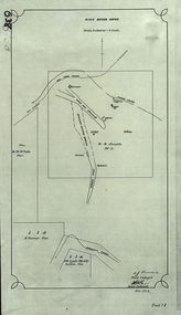
Plan, King River Mine, 1932, 12/1932
... King River Mine, 1932......king river...Copy of a plan of King River Mine....Barker Library (top floor) Mount Helen goldfields mount lyell king river mining tasmania king river mine k.m. white h. turner k.j. finnacane blake Copy of a plan of King River Mine. ...Copy of a plan of King River Mine.mount lyell, king river, mining, tasmania, king river mine, k.m. white, h. turner, k.j. finnacane, blake -
 Bayside Gallery - Bayside City Council Art & Heritage Collection
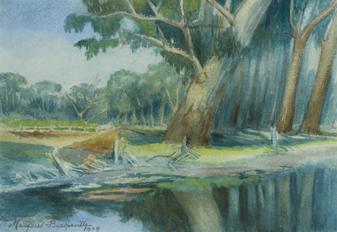
Work on paper - watercolour, Margaret Baskerville, The King River at Wangaratta, 1908-09
... The King River at Wangaratta......king river...Bayside Gallery - Bayside City Council Art & Heritage Collection Corner Wilson and Carpenter Streets Brighton melbourne landscape river king river wangaratta trees watercolour margaret baskerville reflection bush watercolour The King River at Wangaratta Work on paper watercolour Margaret Baskerville ...watercolourlandscape, river, king river, wangaratta, trees, watercolour, margaret baskerville, reflection, bush -
 Kilmore Historical Society
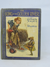
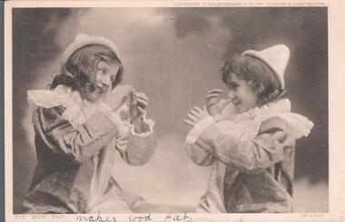
The King of the Golden River, The King of the Golden River & Other Tales, 1908
... The King of the Golden River...The King of the Golden River & Other Tales....Fair condition. The King of the Golden River & Other Tales. The King of the Golden River John Ruskin, etc., etc. ...Collection of stories for children by John Ruskin, Nathaniel Hawthorne, Mrs. Craik, and others. Donated from Monica Smith's (nee Turner) childhood collection. Descendant of early Kilmore Business families the Morrisseys and Hartnells.Blue cloth-bound hardcover with colour plated pasted to front. Gilt border front cover. Very faded spine, some fading & staining back & front. Insect damage front & back flyleaves and half title page. Front hinge broken, binding loose. 159 pp. Fair condition.Inside front cover, 'Monica Turner', pencil, cursive part worn away, Front flyleaf, 'Monica Turner/from C. Whelan/August 7th 1909'children's literature, turner collection -
 Marysville & District Historical Society
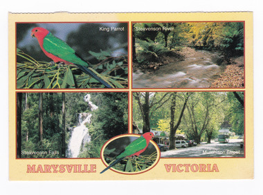
Postcard (item) - Colour postcard, Rose Stereograph Company, MARYSVILLE VICTORIA, Pre 2009
... king parrot...steavenson river...There is a photograph of a King Parrot, the Steavenson River, Steavenson Falls and Murchison Street in Marysville....MARYSVILLE VICTORIA/ King Parrot/ Steavenson River/ Steavenson Falls/ Murchison Street POST CARD The "Rose" Series/ De Luxe Proudly Printed in Australia Since 1880 Four Views of beautiful/ MARYSVILLE, VICTORIA, AUSTRALIA/ Photos: Ken Stepnall, Neil Cutts,/ Marysville Newsagengy AFFIX/ STAMP/ HERE/ Rose Series/ Post Card No./ 3523 ADDRESS/ POSTCODE Copyright Rose Stereograph Co., Glen Waverley, Victoria (03) 9560 7772...There is a photograph of a King Parrot, the Steavenson River, Steavenson Falls and Murchison Street in Marysville. ...A postcard with four colour photographs of natural attractions in and around Marysville in Victoria.A postcard with four colour photographs of natural attractions in and around Marysville in Victoria. The postcard was produced by the Rose Stereograph Co of Australia as a souvenir of Marysville.MARYSVILLE VICTORIA/ King Parrot/ Steavenson River/ Steavenson Falls/ Murchison Street POST CARD The "Rose" Series/ De Luxe Proudly Printed in Australia Since 1880 Four Views of beautiful/ MARYSVILLE, VICTORIA, AUSTRALIA/ Photos: Ken Stepnall, Neil Cutts,/ Marysville Newsagengy AFFIX/ STAMP/ HERE/ Rose Series/ Post Card No./ 3523 ADDRESS/ POSTCODE Copyright Rose Stereograph Co., Glen Waverley, Victoria (03) 9560 7772marysville, victoria, king parrot, steavenson river, steavenson falls, murchison street, postcard, souvenir, rose stereograph co -
 Federation University Historical Collection
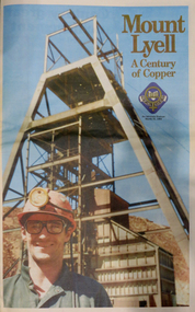
Newspaper, Mt Lyell: A Century of Copper, 22/03/2016
... ...king river...Barker Library (top floor) Mount Helen goldfields mt lyell copper mt lyell centenary keith faulkner mt lyell smelter renison goldfields james smith heemskirk zeehan dundas mt cleveland magnet mt read rosebery savage read balfour t.b. moore t. currie c.h. curtain f. harvey con lynch f.o. henry charles gould tom currie king river copper james crotty iron blow steve karlson bowes kelly lyell mining and roailway co. robert carl stricht penghana f.a. cutten lake margaret power station don clark queenstown eric reece hodfast mine pieman river golden gate gold mine r.m. murray a.h.p. moline frad jakin dave carswell awu australian workers union reg trudgian sulpher renison bell williamsford tullah waratah john pearton gormanston gormanston cork club north lyell mt lyell disaster mount lyell 32 page newspaper relating to the centenary of Mt Lyell copper. ...32 page newspaper relating to the centenary of Mt Lyell copper. mt lyell copper, mt lyell centenary, keith faulkner, mt lyell smelter, renison goldfields, james smith, heemskirk, zeehan, dundas, mt cleveland, magnet, mt read, rosebery, savage read, balfour, t.b. moore, t. currie, c.h. curtain, f. harvey, con lynch, f.o. henry, charles gould, tom currie, king river, copper, james crotty, iron blow, steve karlson, bowes kelly, lyell mining and roailway co., robert carl stricht, penghana, f.a. cutten, lake margaret power station, don clark, queenstown, eric reece, hodfast mine, pieman river, golden gate gold mine, r.m. murray, a.h.p. moline, frad jakin, dave carswell, awu, australian workers union, reg trudgian, sulpher, renison bell, williamsford, tullah, waratah, john pearton, gormanston, gormanston cork club, north lyell, mt lyell disaster, mount lyell -
 Federation University Historical Collection
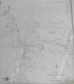
Map, Geological Sketch Map of the Mount Lyell District, 1935, 25-09-1935
... ...king river...mount lyell queenstown mining king river Copy of a plan showing mining leases around Mount Lyell, Tasmania. ...Copy of a plan showing mining leases around Mount Lyell, Tasmania.mount lyell, queenstown, mining, king river -
 Federation University Historical Collection
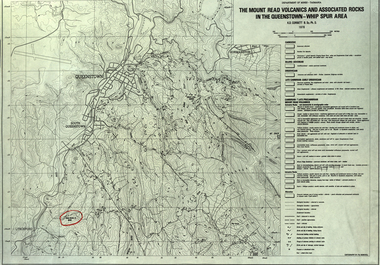
Map, The Mount Read Volcanics and Associated Rocks in the Queenstown - Whip Spur Area, 1978, 1978
... ...king river...department of mines tasmania volcanics mount read queesntown whip spur mining king river gormanston mt owen lynchford Contour map of the Queenstown area in Tasmania, Australia. ...Contour map of the Queenstown area in Tasmania, Australia.department of mines tasmania, volcanics, mount read, queesntown, whip spur, mining, king river, gormanston, mt owen, lynchford -
 8th/13th Victorian Mounted Rifles Regimental Collection
Photograph
... LCpl Van De Velde has a collection of Pandamus Palm nut prematurely ripened by fire near King River Northern Territory....LCpl Van De Velde has a collection of Pandamus Palm nut prematurely ripened by fire near King River Northern Territory. Photograph ...In 1988, as part of a Defence of Mainland Australian policy, defence of facilities of strategic importance in northern Australia were allocated to Army Reserve units. ‘A’ Squadron was allocated the defence of Tindal Air Force base located 15 KM outside Katherine in Northern Territory. Consequently the Squadron deployed on Exercise ‘Northern Explorer’ to gain first-hand knowledge of operating conditions for mounted and dismounted patrolling in the area.Lance Corporal R. Van De Velde, ' A ' Squadron 8/13 VMR during Exercise ' Northern Explorer' September 1988. LCpl Van De Velde has a collection of Pandamus Palm nut prematurely ripened by fire near King River Northern Territory. -
 Bendigo Historical Society Inc.
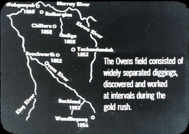
Slide - DIGGERS & MINING: THE DIGGINGS - THE DIGGERS
... Slide depicts: Murrey River, Kiewa River, Ovens River, King River. The Ovens Field consisted of widely separated diggings, discovered and worked at intervals during the gold rush. ...Slide depicts: Murrey River, Kiewa River, Ovens River, King River. The Ovens Field consisted of widely separated diggings, discovered and worked at intervals during the gold rush. ...Diggers & Mining. The Digging - The Diggers. Slide depicts: Murrey River, Kiewa River, Ovens River, King River. The Ovens Field consisted of widely separated diggings, discovered and worked at intervals during the gold rush. Markings: 23 994.LIF:6. Used as a teaching aid.hanimounteducation, tertiary, goldfields -
 Victorian Aboriginal Corporation for Languages
Book, Ron Vanderwal, John Bulmer's recollections of Victorian Aboriginal life, 1855-1908
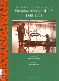
... ...King Charley...Snowy River...Victorian Aboriginal Corporation for Languages 33 Saxon Street Brunswick melbourne Gunai Kurnai Gippsland Lake Tyers Lakes Entrance King Charley Snowy River Ellen Hood Sarah Moffat Lance McDougall Kassie McDougall Tom Foster Alec McCrae Nellie Blair John Bulmer Victorian history Indigenous social life kinship religion and mythology bush foods maps, b&w photograph, word lists, tables John Bulmer spent forty years of his life as missionary to Aboriginal people in Victoria, in 1855 devoting his activities to communities on the Murray, but most of his life was spent at Lake Tyers where he established a Church of England mission in 1862, In his later years he wrote a series of thirteen papers in which he recorded his observations on the life and times of the people to whom he ministered. ...John Bulmer spent forty years of his life as missionary to Aboriginal people in Victoria, in 1855 devoting his activities to communities on the Murray, but most of his life was spent at Lake Tyers where he established a Church of England mission in 1862, In his later years he wrote a series of thirteen papers in which he recorded his observations on the life and times of the people to whom he ministered. Over a period of several years Alistair Campbell transliterated the manuscripts, altering a little but retaining the flavour of the original text.maps, b&w photograph, word lists, tablesgunai kurnai, gippsland, lake tyers, lakes entrance, king charley, snowy river, ellen hood, sarah moffat, lance mcdougall, kassie mcdougall, tom foster, alec mccrae, nellie blair, john bulmer, victorian history, indigenous social life, kinship, religion and mythology, bush foods -
 Wangaratta High School
WHS Magazine -Korrumbeia, 1952
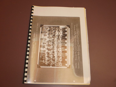
... Korrumbeia is Victorian aboriginal term meaning restful river/creek (Kurrabi; creek, Umina; rest, Beeia; river) This is a reference to the Ovens and King rivers merging in Wangaratta, and the fact that WHS houses are named after local waterways....Korrumbeia is Victorian aboriginal term meaning restful river/creek (Kurrabi; creek, Umina; rest, Beeia; river) This is a reference to the Ovens and King rivers merging in Wangaratta, and the fact that WHS houses are named after local waterways. ...This is the transition year as the Wangaratta High school magazine is renamed to Korrumbeia. Korrumbeia is Victorian aboriginal term meaning restful river/creek (Kurrabi; creek, Umina; rest, Beeia; river) This is a reference to the Ovens and King rivers merging in Wangaratta, and the fact that WHS houses are named after local waterways.Black and white photocopy of the 1952 edition of Korrumbeia featuring a large image of the interschool sports athletics team -
 Melbourne Tram Museum
Document - Photocopy, The Commonwealth Engineer, "Electric Lighting of Melbourne Cable Cars", "Electric Lighting for Melbourne Trams", 1917
... Also has an item about King River hydro electric power and the standardisation of the electrical industry....Also has an item about King River hydro electric power and the standardisation of the electrical industry. ...Photocopy of an article from The Commonwealth Engineer, dated 1/8/1917, titled "Electric Lighting of Melbourne Cable Cars". Describes the battery system, the number of cars, the use of a motor generator at each depot, the lamps and the system on each car. Also has a start of a short item on the Kalgoorlie Electric Tramways Annual report. Short report in the same journal, 1/11/1917 titled Electric Lighting for Melbourne Trams", about a contract issued by the Tramway Board to the General Electric company for approximately 40,000 pounds. Also has an item about King River hydro electric power and the standardisation of the electrical industry.trams, tramways, cable trams, tramcars, lights, depots, general electric -
 Lakes Entrance Historical Society
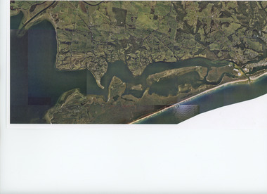
Photograph - Aerial view of Gippsland Lakes/Entrance to Tambo River c1960, Gippsland Ports, 2006 c
... Colour aerial photograph showing the entrance to Gippsland Lakes from Bass Strait westward to Reeves Channel Shaving Point at Metung through Lake King to Tambo River Gippsland Lakes Victoria...Aerial Photograph Waterways Township Topography Lakes Entrance Colour aerial photograph showing the entrance to Gippsland Lakes from Bass Strait westward to Reeves Channel Shaving Point at Metung through Lake King to Tambo River Gippsland Lakes Victoria Photograph Aerial view of Gippsland Lakes/Entrance to Tambo River c1960 Gippsland Ports ...Colour aerial photograph showing the entrance to Gippsland Lakes from Bass Strait westward to Reeves Channel Shaving Point at Metung through Lake King to Tambo River Gippsland Lakes Victoriaaerial photograph, waterways, township, topography, lakes entrance -
 Bendigo Historical Society Inc.
Postcard - Elliot Postcard Collection: Australia, 1895 - 1914
... A. 1405.388 Serpentine Falls, Darling Range, W. A. 1405.389 King River, Albany, W. A. 1405.390 Perth from Terraces, National Park 1405.391 Cave House Yallingup W. ...A. 1405.388 Serpentine Falls, Darling Range, W. A. 1405.389 King River, Albany, W. A. 1405.390 Perth from Terraces, National Park 1405.391 Cave House Yallingup W. ...Thought to have originated in Austria in 1869, postcards first gained popularity in Australia in the 1890s.They were used to send short messages to friends and family. This collection was generated by Mary Emma Elliot of Talgarno. Talgarno is a rural locality in Victoria, Australia, situated on the southern shoreline of Lake Hume, about 23 km east of Albury-Wodonga. The collection contains postcards from across the world. Mary Emma Sibley was born in Ironbark, Bendigo in 1859. She married James Elliot in 1893 and they settled at “Kelso”, Talgarno. They had two children – Mona and Sibley. Mary Emma Elliot died in Melbourne in 1944, aged 84 years. Australian postcards collected by Mrs. James Elliot between 1898 and 1915. 1405.381 A Children's Portrait 1405.382 A Good Story 1405.383 To One I Love 1405.384 Friends 1405.385 St. John's Church Albany W. A. 1405.386 Mill Pond, South Perth W. A. 1405.387 Government Gardens, Perth, W. A. 1405.388 Serpentine Falls, Darling Range, W. A. 1405.389 King River, Albany, W. A. 1405.390 Perth from Terraces, National Park 1405.391 Cave House Yallingup W. A. 1405.392 Presbyterian Church, Perth, W. A. 1405.393 Entrance to King's Park, Perth, W. A. 1405.394 Central Hay Str. Perth, W. A. (Sunday morning) 1405.395 Municipal Gardens, Subiaco, W. A. 1405.396 The Anglican Cathedral, Perth, W. A. 1405.397 Hall and School 1405.398 River Scene 1405.399 Giant Breakers 1405.400 Rough Seas postcards, collecting, collections, talgarno -
 Wodonga & District Historical Society Inc
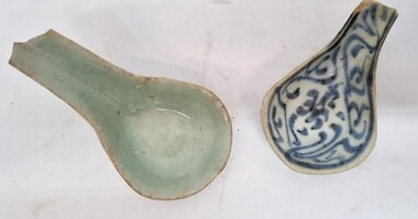
Functional object - Chinese Ceramic Spoons
... However, a number settled in the area as merchants, hawkers and market gardeners in surrounding towns including Wodonga, the Ovens, King, Buffalo River and Kiewa Valleys. They also rented lands and established themselves in the hops and tobacco farming industries. ...However, a number settled in the area as merchants, hawkers and market gardeners in surrounding towns including Wodonga, the Ovens, King, Buffalo River and Kiewa Valleys. They also rented lands and established themselves in the hops and tobacco farming industries. ...During the Victorian goldrushes of the 1850s thousands of Chinese migrants arrived to seek their fortunes. At that time many came to the lucrative gold fields of Northeast Victoria. After the Gold rush, many Chinese migrants returned home. However, a number settled in the area as merchants, hawkers and market gardeners in surrounding towns including Wodonga, the Ovens, King, Buffalo River and Kiewa Valleys. They also rented lands and established themselves in the hops and tobacco farming industries. These spoons were found by Mr Robert Black when he was ploughing a paddock on his farm in Kergunyah, Victoria in the 1930s.2 small ceramic Chinese spoons. Spoon 1 has a clear light green glaze. Spoon 2 is decorated with a blue painted pattern.chinese immigration to victoria, chinese market gardens, chinese migration northeast victoria -
 Wangaratta RSL Sub Branch
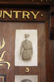
Honour Board, Killawarra State School, C1915
... The latter was 1 of 6 lives lost when they drowned in the disastrous floods of the Ovens and King Rivers on 7/6/1917....The latter was 1 of 6 lives lost when they drowned in the disastrous floods of the Ovens and King Rivers on 7/6/1917. A timber and glass framed Honour Board containing 15 names and 11 black and white photographs of teachers and past students of Killawarra State School who enlisted for military service during World War 1. ...WW1 Killawarra State School 1914-1919 Honour Board contains the names and photographs of teachers and past students who enlisted for military service during World War 1. Owen Francis Private 68800; William Francis Robertson,Sergeant 981/Lieutenant KIA 7/6/1917: Lubin James Robertson,MC and Croix de Guerre L/Cpl 980/Lieutenant; Christopher George Everitt 5882 Died of Wounds 26/4/1918; James Samuel Everitt 3319 KIA 18/7/1916; William John Rhodes 917, Henry Rhodes 2779, Robert Ernest Payne 5215,KIA 15/4/1918; Joseph Adams 10296, Albert Reginald Coppin 57084, Thomas Rhodes, Reserve - Enlisted 15/7/1915 did not embark - discharged medically unfit on 29/4/1916 due to meningitis and lumbago, Henry Sumpton 1827, James Joseph Kellow 6836, William Patrick Toohey 1750 and David William Quinton Clarke 44233 School Teacher Enlisted 15/5/1916 and discharged on 11/7/1916 due to urgent family reasons. Robert "Ernie" PAYNE was a cousin to William,Henry and Thomas RHODES. The latter was 1 of 6 lives lost when they drowned in the disastrous floods of the Ovens and King Rivers on 7/6/1917.A timber and glass framed Honour Board containing 15 names and 11 black and white photographs of teachers and past students of Killawarra State School who enlisted for military service during World War 1. Following the closure of the school the Honor Board was donated to the Wangaratta RSL Sub Branch. In 2018 the community of Killawarra sought the loan of the Honour Board for display in the CFA/Community Hall.Wooden Honour Board containing fifteen names listed in the centre surrounded by 11 numbered photographs.Top - "Killawarra State School/Roll of Honour/For King & Country" Bottom - "The Great War 1914 to 1919"killawarra state school, honour board ww1 -
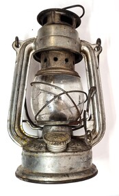 Wodonga & District Historical Society Inc
Domestic object - Kerosene Lantern
... However, a number settled in the area as merchants, hawkers and market gardeners in surrounding towns including Wodonga, the Ovens, King, Buffalo River and Kiewa Valleys. They also rented lands and established themselves in the hops and tobacco farming industries. ...However, a number settled in the area as merchants, hawkers and market gardeners in surrounding towns including Wodonga, the Ovens, King, Buffalo River and Kiewa Valleys. They also rented lands and established themselves in the hops and tobacco farming industries. ...During the Victorian goldrushes of the 1850s thousands of Chinese migrants arrived to seek their fortunes. At that time many came to the lucrative gold fields of Northeast Victoria. After the Gold rush, many Chinese migrants returned home. However, a number settled in the area as merchants, hawkers and market gardeners in surrounding towns including Wodonga, the Ovens, King, Buffalo River and Kiewa Valleys. They also rented lands and established themselves in the hops and tobacco farming industries. Items of Chinese origin made their way into many households. Importation of Chinese mass produced items such as this lantern continued well into the 20th century and were common domestic items across Australia before households were connected to electricity.This item is representation of kerosene / paraffin lamps used throughout Australia to provide lighting inside and outdoors prior to the widespread availability of electricity.A small hurricane lamp with a rounded tank and small carry handle attached to the top. A larger handle is also attached at the top of the frame. It has a lever to open the glass tank. It has a metal base which is filled with kerosene. It has a screw knob to open the kerosene receptacle. The metal hood also has vents. The Chinese characters around the base translate to "Shanghai Guanghuaheng".Around base : Chinese characters. On top : "Made in China KWANG HWA"kerosene lamp, domestic appliances, chinese artefacts -
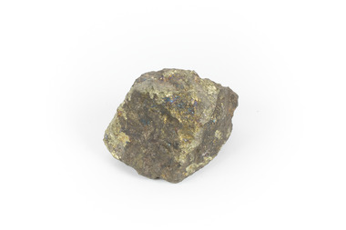 The Beechworth Burke Museum
Geological specimen - Chalcopyrite
... The environmental impacts from this complex of mines are extensive, with waste tailings and heavy metal contamination flowing directly into the King and Queen River catchments. In 1954, the eminent Australian historian, Geoffrey Blainey, published 'The Peaks of Lyell' which delves into the history of the 1912 North Mount Lyell Disaster....The environmental impacts from this complex of mines are extensive, with waste tailings and heavy metal contamination flowing directly into the King and Queen River catchments. In 1954, the eminent Australian historian, Geoffrey Blainey, published 'The Peaks of Lyell' which delves into the history of the 1912 North Mount Lyell Disaster. ...This specimen originated from Mount Lyell on the west coast of Tasmania, where a large group of open cut and underground copper-silver-gold mines began operating in 1883. Between 1893-1994, the Mt Lyell Mining and Railway Company were responsible for operations. The Mt Lyell copper-gold mines produce some excellent crystallised specimens of chalcopyrite and other minerals. The deposits are generally considered to be of Cambrian volcanic origin, but there are indications of Devonian granitic influence on the ores, plus local remobilisation during Devonian deformation. Over 120 million tonnes of ore was produced from several workings, including the main Prince Lyell mine and the North Lyell mine, which was also of great importance. The Mount Lyell mines have a long history of human and environmental disasters, including the 1912 North Lyell fire that killed 42 miners, and two separate incidents in 2013 in which three people lost their lives. The environmental impacts from this complex of mines are extensive, with waste tailings and heavy metal contamination flowing directly into the King and Queen River catchments. In 1954, the eminent Australian historian, Geoffrey Blainey, published 'The Peaks of Lyell' which delves into the history of the 1912 North Mount Lyell Disaster.Chalcopyrite does not contain the most copper in its structure relative to other minerals, but it is the most important copper ore since it can be found in many localities and occurs in a variety of ore types. The brassy-yellow colours in Chalcopyrite mean it is often confused with pyrites and gold, leading to use of the term, "fool's gold." Chalcopyrite has been the primary ore of copper since smelting began five thousand years ago. This specimen is part of a larger collection of geological and mineral specimens collected from around Australia (and some parts of the world) and donated to the Burke Museum between 1868-1880. A large percentage of these specimens were collected in Victoria as part of the Geological Survey of Victoria that begun in 1852 (in response to the Gold Rush) to study and map the geology of Victoria. Collecting geological specimens was an important part of mapping and understanding the scientific makeup of the earth. Many of these specimens were sent to research and collecting organisations across Australia, including the Burke Museum, to educate and encourage further study.This hand sized solid mineral specimen has shades of brass-yellow with spots of iridescent green-black tarnish. Chalcopyrite is a copper iron sulphide mineral and a major ore of copper common in sulphide veins and disseminated in igneous rocks. Chalcopyrite has a hardness of 3.5-4 on the Mohs Scale. It is a member of the tetragonal crystal system and has metallic lustre and opaque transparency.burke museum, beechworth, indigo shire, beechworth museum, geology, geological specimen, chalcopyrite, copper pyrites, copper mining, tasmanian geology, mount lyell, mount lyell mines, fools gold, mohs scale, crystals, minerals, historical geological collection, victorian geological survey, a.r.c selwyn, gold rush, van diemans land -
 Wangaratta Historical Society
Wangaratta Historical Society
... Wangaratta in North East Victoria has a population of over 27 thousand people and is situated at the junction of the King and the Ovens Rivers. Agriculture has always been a big part of its history as well as education, health and manufacturing. ...Wangaratta in North East Victoria has a population of over 27 thousand people and is situated at the junction of the King and the Ovens Rivers. Agriculture has always been a big part of its history as well as education, health and manufacturing. ...The Wangaratta Historical Society Inc. (WHS) was established in 1959 and moved into its present home in the 1970s. Wangaratta in North East Victoria has a population of over 27 thousand people and is situated at the junction of the King and the Ovens Rivers. Agriculture has always been a big part of its history as well as education, health and manufacturing. The museum was originally a fire station built 1895 and included living quarters for its staff. The building is owned by the Rural City of Wangaratta who are great supporters of the WHS The museum was bequeathed 10,000 glass negatives from the late 1800s to the 1950s these were by the Vine & Thelma studios of mostly, portraits, weddings and historical photos. Also owned by the WHS is the Maianne Gibson crazy patchwork quilt made by a Wangaratta woman in the 1890s and now Heritage listed. This Quilt is housed in an specially controlled conditions. The Wangaratta Historical Society Museum was accredited in 2012 under the Museums Accreditation Program. -
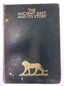 Warrnambool and District Historical Society Inc.
Book, The Ancient East and it's story, 1943
... River mouth. Miss Lake inherited the property and built the residence known as Lyndoch that is today part of the Lyndoch Aged Care Facility. Miss Lake was known for her philanthropy and community work in Warrnambool. John King’s...River mouth. Miss Lake inherited the property and built the residence known as Lyndoch that is today part of the Lyndoch Aged Care Facility. Miss Lake was known for her philanthropy and community work in Warrnambool. John King’s ...This book was given in 1943 by the Warrnambool Technical School to Joyce Goodall. Considering that World War Two was in progress at the time, the book was an expensive one to be given as a school prize. But the donor was Miss Florence Lake, the daughter of John and Annie Lake and the step-daughter of George Rolfe of Lyndoch, near the Hopkins River mouth. Miss Lake inherited the property and built the residence known as Lyndoch that is today part of the Lyndoch Aged Care Facility. Miss Lake was known for her philanthropy and community work in Warrnambool. John King’s name has been crossed out in the book as he was no longer Principal in 1943. He was the founding principal of Warrnambool Technical School in 1911 and remained there for 29 years. The Goodall family established Wanstead Farm in East Warrnambool in the 19th century and Joyce Goodall was descended from the Mortlake branch of that family.This book is of interest because of its association in 1943 with Joyce Goodall, Florence Lake and Warrnambool Technical School. This is a hard cover book of 472 pages. The cover is brown with gold lettering and the image of a lion on the front cover and a scroll pattern on the spine. The book has a preface, 41 chapters and an index. There are eight colour plates scattered throughout the text. The book plate on the first page is printed and pasted in and it has typed material added to it. Another inscription has been handwritten in pencil. There are also several notes and quotations handwritten in pencil on the back page. The cover is stained and torn in some places and many of the pages are stained. ‘Warrnambool Technical School, Labor to Efficiency, 8th December 1943, for Outstanding Efficiency in Art Subjects, Donated by Miss Lake, Awarded to Joyce Goodall, John King Principal’ (the name ‘John King’ has been crossed out) ‘Joyce Goodall 198 Timor Street Warrnambool’ joyce goodall, florence lake, warrnambool technical school, history of warrnambool -
 Bendigo Military Museum
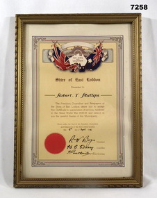
Certificate - SHIRE OF EAST LODDON, FRAMED, Arnall & Jackson, c.1940's
... KING/ AND/ COUNTRY" from 'SHIRE OF EAST LODDON" "CERTIFICATE IN APPRECIATION FOR SERVICES RENDERED IN THE GREAT WORLD WAR 1939-45" "Robert T. Phillips" Robert Thomas Phillips V28869 (AMF) VX113093 (2nd AIF). Enlisted 16.12.1941 age 20 years 7 months as V28869, transferred to the AIF 14.10.1942 in 2/2nd Tank Transporter Coy ASC, listed as served in Adelaide River, Winnellie and Darwin between 25.11.1943 to 23.9.1945. ...KING/ AND/ COUNTRY" from 'SHIRE OF EAST LODDON" "CERTIFICATE IN APPRECIATION FOR SERVICES RENDERED IN THE GREAT WORLD WAR 1939-45" "Robert T. Phillips" Robert Thomas Phillips V28869 (AMF) VX113093 (2nd AIF). Enlisted 16.12.1941 age 20 years 7 months as V28869, transferred to the AIF 14.10.1942 in 2/2nd Tank Transporter Coy ASC, listed as served in Adelaide River, Winnellie and Darwin between 25.11.1943 to 23.9.1945. ...Certificate "FOR KING/ AND/ COUNTRY" from 'SHIRE OF EAST LODDON" "CERTIFICATE IN APPRECIATION FOR SERVICES RENDERED IN THE GREAT WORLD WAR 1939-45" "Robert T. Phillips" Robert Thomas Phillips V28869 (AMF) VX113093 (2nd AIF). Enlisted 16.12.1941 age 20 years 7 months as V28869, transferred to the AIF 14.10.1942 in 2/2nd Tank Transporter Coy ASC, listed as served in Adelaide River, Winnellie and Darwin between 25.11.1943 to 23.9.1945. Discharged 19/10/45 with the rank CPL in A.A. Pay Corps.CERTIFICATE - ORIGINAL, ON PAPER. Dark Brown print. Illustrated in colours, red, blue, yellow and beige. Top - Rising Sun Badge with British and Australian Flags, outline map of Australia and surrounded by decorative scroll work. Bottom - Red seal. Certificate framed with decorative line and scroll work. Frame - timber, gold colour paint with black paint highlights to decorate moulding. Glass front. Backing - cardboard and brown paper. Original metal hanging clips and cotton cord.Handwritten in black ink: "Robert T. Phillips" - 6th April 1946, Signed by R.W. Bogie, President. H.C....???...... Councilor, A. Gutherie Shire Secretary.framed accessories, certificate, ww2, shire of east loddon -
 Orbost & District Historical Society
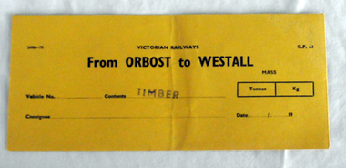
railways envelope, C 1980's
... King railway coachbuilding factory. The station was opened to the public on 1 June 1959 when all trains on the line began stopping there. The Bairnsdale-Orbost railway was opened in 1916 to serve the agricultural and timber industry. Because of the decline in traffic and heavy operating costs, the line was finally closed in August, 1987. Orbost Railway Station was opened on Monday 10 April 1916 as the terminus of the Orbost railway line, and closed in 1987. The station was located on the west side of the Snowy River...King railway coachbuilding factory. The station was opened to the public on 1 June 1959 when all trains on the line began stopping there. The Bairnsdale-Orbost railway was opened in 1916 to serve the agricultural and timber industry. Because of the decline in traffic and heavy operating costs, the line was finally closed in August, 1987. Orbost Railway Station was opened on Monday 10 April 1916 as the terminus of the Orbost railway line, and closed in 1987. The station was located on the west side of the Snowy River ...This item was used by Victorian Railways 1970's/1980's. It was used at Orbost Railway Station for the consignment of timber from Orbost to Westall.. Westall was a major timber-receiving depot near Dandenong, Victoria. Westall railway station is located on the Pakenham and Cranbourne lines in Victoria, Australia. It serves the south-eastern Melbourne suburb of Clayton South, opening on 6 February 1951. Westall station was opened as a workers only platform on 16 October 1954. It was provided for the adjacent Martin & King railway coachbuilding factory. The station was opened to the public on 1 June 1959 when all trains on the line began stopping there. The Bairnsdale-Orbost railway was opened in 1916 to serve the agricultural and timber industry. Because of the decline in traffic and heavy operating costs, the line was finally closed in August, 1987. Orbost Railway Station was opened on Monday 10 April 1916 as the terminus of the Orbost railway line, and closed in 1987. The station was located on the west side of the Snowy River despite the town of Orbost being on the east side of the river, in order to save on the costs of a bridge over the river, which at the time had highly variable levels. This item is associated with the history of the Orbost-Bairnsdale railway line and therefore reflects the role that the rail line played in the social and economic history of Orbost.An unused brown/buff coloured goods/freight consignment envelope used by Victorian Railways, this one for timber from Orbost to Westall. It is DL size.2497-78 VICTORIAN RAILWAYS G.F 63 From ORBOST to WESTALL MASS Tonnes kg Vehicle No Contents TIMBER Consignee Date orbost-bairnsdale-railway westall -
 Orbost & District Historical Society
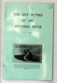
book, James Yeates & Sons (Printing) Pty Ltd, The Silk Jetties of the Mitchell river, 1972
... They have been formed over millions of years by sediment deposition from the Mitchell River during periods of low water flow and subsequent wash-through during periods of high water flow. The long narrow banks of silt extend more than eight kilometres east into Lake King. ...They have been formed over millions of years by sediment deposition from the Mitchell River during periods of low water flow and subsequent wash-through during periods of high water flow. The long narrow banks of silt extend more than eight kilometres east into Lake King. ...This booklet was the first of a series of scientific and historical studies of Gippsland to be published by the Bairnsdale Advertiser. The author, Eric Charles Frederick Bird was Principal Fellow, Department of Geography, University of Melbourne, Australia. The Mitchell River silt jetties are an unusually long, thin landform located in the Gippsland Lakes region. They have been formed over millions of years by sediment deposition from the Mitchell River during periods of low water flow and subsequent wash-through during periods of high water flow. The long narrow banks of silt extend more than eight kilometres east into Lake King. This item is a useful reference for the silt jetties of the Mitchell River.A 32 pp book with alight green cover. The title is in black print, " The Silk Jetties of the Mitchell River" and underneath the title there is a b/w photograph of the Mitchell River and silt jetties taken from above in 1931. It was written by E. C. F. Bird.silt-jetties mitchell-river paynesville bird-e.c.f. -
 Federation University Historical Collection
Report, Port Fairy: Environmental/Physical Plan, 1999, 11/06/1999
... Barker Library (top floor) Mount Helen goldfields victorian tourisim industry tourism port fairy alumni port fairy folk festival griffith island portland pea soup mott's cottage mill's cottage port fairy lighthouse moyne river Report compiled by fivestudents of Tourism at University of Ballarat (later Federation University Australia) Port Fairy: Environmental/Physical Plan, 1999 Report Damien King Morag Marjoribanks Belinda Pearce Rebecca Plant Marc Wright ...Report compiled by fivestudents of Tourism at University of Ballarat (later Federation University Australia)victorian tourisim industry, tourism, port fairy, alumni, port fairy folk festival, griffith island, portland, pea soup, mott's cottage, mill's cottage, port fairy lighthouse, moyne river -
 Lara RSL Sub Branch
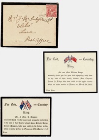
Sympathy Cards Mc Intyre, 1917 and 1918
... River and the other from Mr. and Mrs. J Duggan Lara on the loss of their son Private Horace James Duggan. (France 27th March 1918) For God, King and Country with the Australian and English flag. ...River and the other from Mr. and Mrs. J Duggan Lara on the loss of their son Private Horace James Duggan. (France 27th March 1918) For God, King and Country with the Australian and English flag. 2 Cards and one envelope stuck to white a4 paper Sympathy Cards Mc Intyre ...Standard sympathy cards sent by family acknowledging the loss of their sons killed during World War OneStandard sympathy cards sent by parents acknowledging letters of sympathy sent to them on the loss of their sons.2 Cards and one envelope stuck to white a4 paperEnvelope Addressed to Mrs J MC Intyre Elcho Lara Australia, includes a one penny stamp. Two standard printed Cards " Thanking you for your kind Sympathy ........." . One card from Mr. and Mrs. Lodge for the loss of their son Corporal James A lodge ( France March 26 1917) Little River and the other from Mr. and Mrs. J Duggan Lara on the loss of their son Private Horace James Duggan. (France 27th March 1918) For God, King and Country with the Australian and English flag. -
 Eltham District Historical Society Inc
Photograph - Digital Photograph, Alan King, Diamond Creek, Barak Bushlands, Eltham, 2008
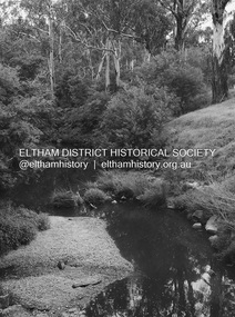
... King with Marguerite Marshall.; p185 Barak Bushlands lie west of the Diamond Creek on the corner of Falkiner Street and busy, noisy Main Road. They form part of an important habitat corridor linking the Yarra River to the Kinglake National Park.1 Manna Gums, tawny frogmouths and platypuses are some of the indigenous plants and animals that have made their home there. ...King with Marguerite Marshall.; p185 Barak Bushlands lie west of the Diamond Creek on the corner of Falkiner Street and busy, noisy Main Road. They form part of an important habitat corridor linking the Yarra River to the Kinglake National Park.1 Manna Gums, tawny frogmouths and platypuses are some of the indigenous plants and animals that have made their home there. ...A habitat corridor and it strengthens the community. Published: Nillumbik Now and Then / Marguerite Marshall 2008; photographs Alan King with Marguerite Marshall.; p185 Barak Bushlands lie west of the Diamond Creek on the corner of Falkiner Street and busy, noisy Main Road. They form part of an important habitat corridor linking the Yarra River to the Kinglake National Park.1 Manna Gums, tawny frogmouths and platypuses are some of the indigenous plants and animals that have made their home there. The bushlands are the result of more than nine years of hard work by the local community with the Nillumbik Council, to transform a degraded flood plain into this refuge of natural beauty. In 1997, shortly after moving into the new Riverside Estate on Falkiner Street, Eltham, several residents noticed the sorry state of the Diamond Creek and surrounding area. Part of it was used as a cow paddock and although small patches of vegetation survived, the area was infested with weeds, rabbits, rubbish and drainage from the housing estate. At various times the 4.4 hectares had been used as a market garden and for shire stock piles. The residents began to restore the area by revegetating land along the Diamond Creek. In 1998 they established the Friends of the Diamond Creek Falkiner Street Reserve2 and 35 families joined from the 90-house Estate. Carolyn Mellor, as the Friends’ Land Manager, undertook a four-year horticulture course to guide this massive project for a volunteer organisation. Since 1999, she has been the Friends’ President. In 1999 the Friends urged the Nillumbik Council to undertake a feasibility study into establishing a wetland system and urban forest. Work began in 2002 with Nillumbik Council funding the project, supplemented by government grants. The Friends also received grants from Melbourne Water and Parks Victoria. Aided by the Friends and other community members, the Council created the Barak Bushlands consisting of a forest, a wetland, a bridge, a path and open space. The beautiful wetland treats most of the estate’s stormwater runoff. Storm water is filtered through plants in the wetland ponds then is released slowly into the billabong, before flowing into the Diamond Creek. The wetland also helps to minimise flooding and the improved water quality provides a flora and fauna habitat. The Friends and other volunteers planted more than 27,000 plants, more than one third of which they grew from seeds they collected at Lower Eltham and Wingrove Parks. Eltham High School students planted thousands of these through a Year Eight program introduced for this purpose. Other groups who assisted were: Green Corps, local Scouts and Guides – 2nd Montmorency, 1st Diamond Creek and 1st Eltham Cub Packs, Eltham College students, Eltham East Primary School, Landcare members, Eltham Lions Club and the Eltham Baptist Church. To maintain enthusiasm for the mammoth task, the Friends and other volunteers ‘adopted’ trees to water and wrote their names on the stakes. In 2004, to recognise the area’s original occupiers, the reserve was named Barak Bushlands. William Barak, who lived from 1824 to 1903, was the last chief of the Yarra Yarra tribe of the Wurundjeri-willam people. Traces of these original inhabitants remain in scar trees (bark sections removed to make a shield or canoe). That same year the Friends’ group was a finalist in the prestigious Federal Government, Banksia Environmental Awards. The Friends have also participated in Clean Up Australia, removing tonnes of rubbish and regularly testing the billabong, wetland and creek, for pollutants. For years the Friends, together with the Australian Platypus Conservancy, have tagged, measured and checked the health of platypuses from the Diamond and Mullum Mullum Creeks. With Latrobe University the Friends have conducted night walks to view owls, possums, bats and sugar gliders. Challenges for the council and the Friends continue with a large rabbit population, some vandalism, weed eradication and maintenance. However, thanks to this community effort, locals can now escape confined urban living on small blocks of land and enjoy the beauty of indigenous plants and animals. Working together has also strengthened the local community,This collection of almost 130 photos about places and people within the Shire of Nillumbik, an urban and rural municipality in Melbourne's north, contributes to an understanding of the history of the Shire. Published in 2008 immediately prior to the Black Saturday bushfires of February 7, 2009, it documents sites that were impacted, and in some cases destroyed by the fires. It includes photographs taken especially for the publication, creating a unique time capsule representing the Shire in the early 21st century. It remains the most recent comprehenesive publication devoted to the Shire's history connecting local residents to the past. nillumbik now and then (marshall-king) collection, barak bushlands, diamond creek (creek), eltham -
 Eltham District Historical Society Inc
Photograph - Digital Photograph, Alan King, Sign: Clara Southern, Heidelberg School Artists Trail, Main Road, Research, 2008
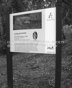
... King with Marguerite Marshall.; p189 Since early in the 20th century this district has attracted artists and other creative people. So much so, that Eltham has been compared to the Left Bank in Paris, New York’s Greenwich Village and London’s Bloomsbury. That is until the 1970s when Eltham rapidly expanded into a suburb. However many artists still flourish not only in Montsalvat, Dunmoochin and the Bend of Islands but elsewhere in Nillumbik. Some artists who have worked or lived in Nillumbik are well-known nationally and internationally. Artists are attracted to the hilly district’s subtle colours, unique light and the Yarra River...King with Marguerite Marshall.; p189 Since early in the 20th century this district has attracted artists and other creative people. So much so, that Eltham has been compared to the Left Bank in Paris, New York’s Greenwich Village and London’s Bloomsbury. That is until the 1970s when Eltham rapidly expanded into a suburb. However many artists still flourish not only in Montsalvat, Dunmoochin and the Bend of Islands but elsewhere in Nillumbik. Some artists who have worked or lived in Nillumbik are well-known nationally and internationally. Artists are attracted to the hilly district’s subtle colours, unique light and the Yarra River ...Warrandyte artist, Clara Southern, features on the Artists Trail. Published: Nillumbik Now and Then / Marguerite Marshall 2008; photographs Alan King with Marguerite Marshall.; p189 Since early in the 20th century this district has attracted artists and other creative people. So much so, that Eltham has been compared to the Left Bank in Paris, New York’s Greenwich Village and London’s Bloomsbury. That is until the 1970s when Eltham rapidly expanded into a suburb. However many artists still flourish not only in Montsalvat, Dunmoochin and the Bend of Islands but elsewhere in Nillumbik. Some artists who have worked or lived in Nillumbik are well-known nationally and internationally. Artists are attracted to the hilly district’s subtle colours, unique light and the Yarra River and Diamond Creek. The railway’s extension to Eltham in 1902 brought artists to paint for the day or to camp. Then many settled in Eltham, perhaps also because the poor quality land, far from the city, was cheap. Following World War Two they found they could build houses and studios cheaply by making their own mud-bricks. The flexible material, with its warm tones blending into the bush, also satisfied their aesthetic sensibilities. As early as 1900, Will Longstaff, known for his painting The Ghosts of Menin Gate at the National War Memorial in Canberra, lived at Stanhope in Peter Street, Eltham, later to become the home of intellectuals Clem and Nina Christensen. Members of Australia’s first significant art movement, the Heidelberg School of Artists, painted in Eltham, Warrandyte and Diamond Creek. Walter Withers lived at the corner of Bolton and Brougham Street, Eltham and taught Sir Hans Heysen, who for a short while stayed with the Withers family. In Warrandyte were Clara Southern, whom Frederick McCubbin taught at the National Gallery School and Penleigh Boyd, who is represented in all Australian state galleries and the National Collection in Canberra. May Vale, daughter of politician William, lived in Diamond Creek. With Jane Price they feature on the Heidelberg School Artists Trail, part of which runs through Nillumbik. The trail includes signs each displaying a reproduction of a painting by an artist and located near where the artist lived or painted. In Nillumbik the trail includes parts of Warrandyte, Eltham in the Alistair Knox Park, Main Road shopping precinct and Wingrove Park, the Research walking track on Main Road and the Diamond Creek Reserve. In 1916 artist William ‘Jock’ Frater lived at the corner of Arthur and Bible Streets, Eltham. Before then, Frater, with other artists including Percy Leason (who moved to Eltham in the mid 1920s) painted in Eltham on weekends. They camped near Bible and Pitt Streets and along the Diamond Creek where the Eltham Retirement Centre now stands.4 In 1921, painter Peter Newbury (father to painter David Newbury, who was born in Eltham) moved to Cromwell Street, Eltham. Max Meldrum, the first Australian painter to formulate a consistent theory of art largely based on tone,5 taught local artists Alan Martin, Clarice Beckett, Peter Glass and Justus Jörgensen. Meldrum visited Eltham then rented a house there for 18 months opposite Wingrove Park. In 1934, artist and architect Justus Jörgensen and his doctor wife Lil and friends built Montsalvat, the artists’ colony. Montsalvat has played an important part in attracting artists to Eltham and its mud-brick, pisé, stone and recycled building materials has had a major influence on Eltham’s built environment. Jörgensen’s students who also helped him build Monstalvat included Arthur Munday, Lesley Sinclair, Helen Lempriere, Joe Hannan, Helen, Sonia and jeweller/sculptor, Matcham Skipper. Among artists who visited Montsalvat were Clifton Pugh and Angry Penguins’ artists Albert Tucker and Arthur Boyd. Some who painted after World War Two were Alan Martin of Eltham and Warrandyte artists Frank Crozier and Harry De Hartog6, one of Melbourne’s first painters influenced by Cubism.This collection of almost 130 photos about places and people within the Shire of Nillumbik, an urban and rural municipality in Melbourne's north, contributes to an understanding of the history of the Shire. Published in 2008 immediately prior to the Black Saturday bushfires of February 7, 2009, it documents sites that were impacted, and in some cases destroyed by the fires. It includes photographs taken especially for the publication, creating a unique time capsule representing the Shire in the early 21st century. It remains the most recent comprehenesive publication devoted to the Shire's history connecting local residents to the past. nillumbik now and then (marshall-king) collection, clara southern, main road, research (vic), heidelberg school artists trail -
 Eltham District Historical Society Inc
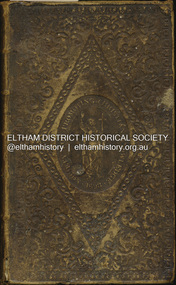
Book - Family Bible, King James Version, Aug. 1834
... Benjamin Whatmough Holy Bible James Whatmough Jemima Fielding (nee Whatmough) Jessy Whatmough Job Whatmough Margaret Whatmough Mary Ann Whatmough Mary Whatmough (nee Hill) Robert Whatmough Robert William Watmough Sarah Whatmough Tom Fielding Collection Plenty River Pioneer Family Hemmett Whatmough Robert Emmett Whatmough Digital scan copy only of pages from Bible on loan from private collection with Births and Deaths recorded inside front cover King James Version Book Family Bible ...King James Bible published Aug. 1934 Family Bible of Robert William Whatmough and Mary Whatmough (nee Hill), married August 4, 1839 in Manchester, Lancashire, England and migrated to Australia with baby daughter Jemima, arriving Port Phillip Bay 19 February 1841. Inscribed in ink on inside front cover: Jemima Whatmough born January 18th 1840 on Saturday Hemmet Whatmough born March 26th 1842 on Saturday Job Whatmough born May 11th 1844 Saturday Died April 12th 1845 Sarah Whatmough born September 17th 1845 James Whatmough born June 28, 1847 Died February 1st 1848 Margaret Whatmough born June 15th 1848 Died March 24th 1850 Jessy Whatmough born January 26, 1851 Inscribed in ink on inside front cover facing page: William Jordison’s Thirty knoul (?) Bok (?) 25th – 1839 ROBERT WHATMOUGH BOOK Presented by Mr. Ferguson Robert Whatmough Presented By the Teacher Mary Ann Whatmough born September 4th 1853 Died November 11th Friday 1853 Benjamin Whatmough born 25 July 1854 Died January 2 1855 Inscribed in ink on inside rear cover facing page over: 1852 This Book Belongs to Mr. Robt. Whatmough On the River Plenty September 16th And in pencil: presented by mr sanger Jemima Whatmough married Robert Fielding on June 23, 1859 at Fitzroy, Victoria According Steve Whatmough (and sister Barbara, email 5/10/2024), Hemmet Whatmough was known as Robert Emmett Whatmough and was always refered to as Emmett within the family.benjamin whatmough, holy bible, james whatmough, jemima fielding (nee whatmough), jessy whatmough, job whatmough, margaret whatmough, mary ann whatmough, mary whatmough (nee hill), robert whatmough, robert william watmough, sarah whatmough, tom fielding collection, plenty river, pioneer family, hemmett whatmough, robert emmett whatmough -
 Eltham District Historical Society Inc
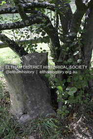
Photograph - Digital Photograph, Alan King, Heritage apple tree, 24 January 2008
... King) Collection...Greensborough...John Batman Tree...Plenty River...River near Leischa Court, Greensborough. It is said that Melbourne Founder John Batman may have planted the tree and later signed his treaty here with the Aboriginal people. It still bears fruit and its recorded on the National Trust's Register of Significant Trees, as the oldest apple tree in Victoria. Published: Nillumbik Now and Then / Marguerite Marshall 2008; photographs Alan King...Nillumbik Now and Then (Marshall-King) Collection Greensborough John Batman Tree Plenty River Trail Born digital image file Heritage apple tree Photograph Digital Photograph Alan King Alan King Marguerite Marshall ...This old apple tree situated beside the Plenty River Trail at Greensborough has been associated with Melbourne Founder John Batman. The concrete block is inscribed with the date 1841, when the tree was thought to have been planted. Known as Batman's Tree, this apple tree is on the bank of the Plenty River near Leischa Court, Greensborough. It is said that Melbourne Founder John Batman may have planted the tree and later signed his treaty here with the Aboriginal people. It still bears fruit and its recorded on the National Trust's Register of Significant Trees, as the oldest apple tree in Victoria. Published: Nillumbik Now and Then / Marguerite Marshall 2008; photographs Alan King with Marguerite Marshall.; p7This collection of almost 130 photos about places and people within the Shire of Nillumbik, an urban and rural municipality in Melbourne's north, contributes to an understanding of the history of the Shire. Published in 2008 immediately prior to the Black Saturday bushfires of February 7, 2009, it documents sites that were impacted, and in some cases destroyed by the fires. It includes photographs taken especially for the publication, creating a unique time capsule representing the Shire in the early 21st century. It remains the most recent comprehenesive publication devoted to the Shire's history connecting local residents to the past. nillumbik now and then (marshall-king) collection, greensborough, john batman tree, plenty river trail -
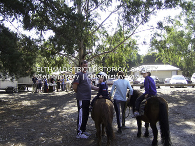 Eltham District Historical Society Inc
Photograph - Digital Photograph, Marguerite Marshall, Eltham Lower Park, 20 April 2008
... King with Marguerite Marshall.; p45 Once used for horse racing, which attracted visitors from Melbourne, the Eltham Lower Park has brought the community together with a wide range of activities. Horse riding is now enjoyed as a recreation in the park as are other sports. The park also includes the Diamond Valley Railway miniature trains and a sanctuary for the rare and vulnerable Eltham Copper Butterfly. Eltham Lower Park, with other parks, forms an almost continuous green band from Eltham’s centre, along the Diamond Creek to the Yarra River...King with Marguerite Marshall.; p45 Once used for horse racing, which attracted visitors from Melbourne, the Eltham Lower Park has brought the community together with a wide range of activities. Horse riding is now enjoyed as a recreation in the park as are other sports. The park also includes the Diamond Valley Railway miniature trains and a sanctuary for the rare and vulnerable Eltham Copper Butterfly. Eltham Lower Park, with other parks, forms an almost continuous green band from Eltham’s centre, along the Diamond Creek to the Yarra River ...Originally a race course, the park has brought the community together with a variety of activities. Published: Nillumbik Now and Then / Marguerite Marshall 2008; photographs Alan King with Marguerite Marshall.; p45 Once used for horse racing, which attracted visitors from Melbourne, the Eltham Lower Park has brought the community together with a wide range of activities. Horse riding is now enjoyed as a recreation in the park as are other sports. The park also includes the Diamond Valley Railway miniature trains and a sanctuary for the rare and vulnerable Eltham Copper Butterfly. Eltham Lower Park, with other parks, forms an almost continuous green band from Eltham’s centre, along the Diamond Creek to the Yarra River.1 Before European settlement the Wurundjeri people met on this land, particularly at the junction of the Diamond Creek with the Yarra River, which they called Birr-arung. This is commemorated by the sculpture, Not just a Pretty Place by Aleks Danko, winner of the 2000 Nillumbik Art in Public Places Award. The first European to settle here was probably Henry Foley, who in 1841 used it as part of his pastoral run. Foley sold his leasehold to Joseph Wilson in 1845, who soon after sold it to Frederick Falkiner. During the 1840s the future park was part of a government square mile (2.6 sqkm) reserve, north of the Yarra, within the Parish of Nillumbik, later named Eltham. Soon the land was used for horse racing after nearby residents cleared ten acres (4ha) in the early 1850s. A three-quarter of a mile (1.2km) race secured the winner the £10 Publican’s Prize. In response to popular demand, the newly formed Eltham District Road Board petitioned the Surveyor General of the Colony of Victoria, in 1856, for 36 acres (14.6ha) of crown land for a racecourse and recreation. By 1858 the Eltham races had become an institution. ‘Many skirmishes occurred and the way home was paved with temptation, with sly-grog for sale.3 In the early 1870s, two jockeys were sons of the police officer in charge of the Eltham Police Station, Miles S Lyons. Another ten acres (4ha) was added to the area in 1866 and 12 acres (4.8ha) – Hohnes Hill – in 1870. In 1866, two acres (0.8ha) on the creek banks became an animal pound with William Walsh the pound keeper in 1870, but this was later incorporated into the park. By 1877 the area was called a public park but horse racing and training continued into the 1920s. In the mid-1900s trotters were trained on a circuit road. In 1953 the Eltham Pony Club was established and used a cross-country course on Hohnes Hill. From the mid 1950s the club held the Eltham Easter Fair at the park, later to include a procession along Main Road from the town centre to the park. The park also attracted picnic parties and campers from the inner suburbs as did Wingrove Park, and businesses catering for visitors, sprang up on the opposite side of Main Road. Bus-loads of school children visited the park for Gould League bird days in the 1960s. In 1979 the Eltham Shire Council bought Lenister Farm, linking the park with the Yarra River. The Lenister Farm wetland includes a bird hide, viewing platform and interpretive signs.5 Pioneer Henry Stooke, later Road Board chairman, bought the 11 acres (4.5ha) - later to become Lenister Farm - from the Crown in 1862. Stooke never lived on this site and the two houses at Lenister Farm were built in the 20th century. Since its formation in 1871, the Council has controlled this crown land, which it named Eltham Park. But in the 1920s Eltham Council bought land near the town centre for a park, which it named Eltham Central Park. To avoid confusion the Council renamed Eltham Park, Eltham Lower Park. Since 2004 the Yarra footbridge has linked the park with the Yarra Valley Metropolitan Park and the Main Yarra Trail.This collection of almost 130 photos about places and people within the Shire of Nillumbik, an urban and rural municipality in Melbourne's north, contributes to an understanding of the history of the Shire. Published in 2008 immediately prior to the Black Saturday bushfires of February 7, 2009, it documents sites that were impacted, and in some cases destroyed by the fires. It includes photographs taken especially for the publication, creating a unique time capsule representing the Shire in the early 21st century. It remains the most recent comprehenesive publication devoted to the Shire's history connecting local residents to the past. nillumbik now and then (marshall-king) collection, eltham lower park, eltham park