Showing 27 items matching "land sales bacchus marsh"
-
 Bacchus Marsh & District Historical Society
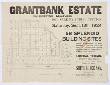
Map - Land Sales Plan, Grantbank Estate Bacchus Marsh, 1924
... Land Sales Bacchus Marsh...The map is significant for the detailed information it provides about when and where land was sold for new housing estates in Bacchus Marsh in the early twentieth century. Land Sales Bacchus Marsh Land Subdivsion Bacchus Marsh Housing Estates Land Sales Bacchus Marsh Grant Family Bacchus Marsh Printed paper map Grantbank Estate Bacchus Marsh Map Land Sales Plan ...The Grantbank Estate was a parcel of land close to the centre of the shopping area of Bacchus Marsh which was sub-divided and offered for sale in 58 lots on the 13th September, 1924. It comprised an area of 15 acres, being a portion of the Millbank Estate which had been in the hands of the Grant family for 75 years. The lots had frontages to Gisborne Road, Patterson, William and Sutherland Streets. This was a significant sub-division of land and represented a major expansion of residential housing in Bacchus Marsh in the early 20th century.This land sale map is a typical example of housing estate land sales advertising maps produced by real estate agents in this era. The map is significant for the detailed information it provides about when and where land was sold for new housing estates in Bacchus Marsh in the early twentieth century.Printed paper mapland sales bacchus marsh, land subdivsion bacchus marsh, housing estates land sales bacchus marsh, grant family bacchus marsh -
![Map, Millbank Estate Bacchus Marsh Thursday 4th October 1888 [Land sales], 1924](/media/collectors/5e461d8021ea67224c82f2a1/items/67765662eb6d2cbd24e0797f/item-media/67765682eb6d2cbd24e07a41/item-fit-380x285.jpg?cb=6) Bacchus Marsh & District Historical Society
Bacchus Marsh & District Historical SocietyMap, Millbank Estate Bacchus Marsh Thursday 4th October 1888 [Land sales], 1924
... Land Sales Bacchus Marsh...The map is significant for the detailed information it provides about when and where land was sold for new housing estates in Bacchus Marsh in the late nineteenth century. Land Sales Bacchus Marsh Land Subdivsion Bacchus Marsh Housing Estates Land Sales Bacchus Marsh Grant Family Bacchus Marsh Millbank Estate Land Sales Single page map showing land allotments for sale at auction in Bacchus Marsh in October 1888. ...The Millbank Estate was a parcel of land close to the centre of the shopping area of Bacchus Marsh which was sub-divided and offered for sale in 62? lots on the 4th October 1888. The lots had frontages to Ballarat Road (Main Street), Maddingley Road (now Grant Street), Turner Street, Millbank Street, Clarinda Road (now Clarinda Street), and an unnamed street south of Turner Street (possibly known as Grant Street at this time) which connected to Maddingley Road through the vicinity of the present day Bacchus Marsh Hospital. This was a significant sub-division of land and represented a major expansion of residential housing in Bacchus Marsh in the late 19th century. The map includes a wealth of detail about the time of the sale, where it will take place, who the selling agents were, the deposit terms for purchases and details of a special train from Melbourne to Bacchus Marsh on sale day. The location of the allotments in relation to the shopping and commercial area of Bacchus Marsh, Maddingley and the railway station are indicated on an inset map within the overall map and poster. The Millbank Estate area was an area which had once belonged to the Grant family who were prominent early citizens of Bacchus Marsh and lived in a house in this area known as 'Millbank'.This land sale map is a typical example of housing estate land sales advertising maps produced by real estate agents in this era. The map is significant for the detailed information it provides about when and where land was sold for new housing estates in Bacchus Marsh in the late nineteenth century.Single page map showing land allotments for sale at auction in Bacchus Marsh in October 1888. A significant portion of the map is missing from the bottom right side. land sales bacchus marsh, land subdivsion bacchus marsh, housing estates land sales bacchus marsh, grant family bacchus marsh, millbank estate land sales -
 Bacchus Marsh & District Historical Society
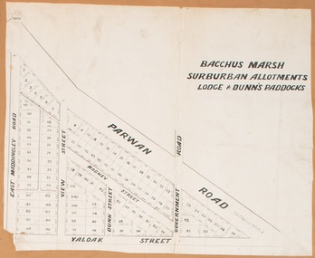
Map, Bacchus Marsh Suburban Allotments Parwan Road Lodge & Dunn's Paddocks 1888
... Land Sales Bacchus Marsh...Bacchus Marsh & District Historical Society Lerderderg Library Main Street Bacchus Marsh This map was created as a plan for an auction of land close to the Bacchus Marsh Railway Station. The auction took place on 23 October 1888. 102 allotments of land from an area known as Lodge and Dunn's paddocks was offered for sale. Land Sales ...This map was created as a plan for an auction of land close to the Bacchus Marsh Railway Station. The auction took place on 23 October 1888. 102 allotments of land from an area known as Lodge and Dunn's paddocks was offered for sale. A single page paper map showing allotments of land for sale along the Parwan Road in Maddingley. The map is pasted into a bound volume containing 76 maps or plans in total. High resolution digital image stored on BMDHS computer network. land sales bacchus marsh, land sales maddingley, bacchus marsh victoria maps, maddingley victoria maps -
 Bacchus Marsh & District Historical Society
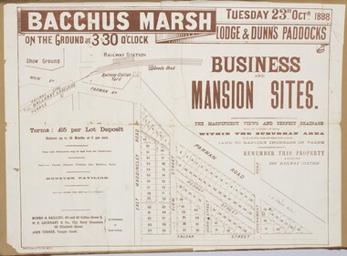
Map, Bacchus Marsh Tuesday 23rd Oct. 1888, Lodge & Dunn's Paddocks 1888. Business and Mansion Sites
... Land Sales Bacchus Marsh... Bacchus Marsh Land Sales Maddingley Bacchus Marsh Victoria Maps Maddingley Victoria Maps At bottom on left side: 'Harston & Co. ...This map was created as a plan for an auction of land close to the Bacchus Marsh Railway Station. The auction took place on 23 October 1888. 102 allotments of land from an area known as Lodge and Dunn's paddocks was offered for sale. The auction was conducted by auctioneers based in Melbourne and was advertised in Melbourne newspapers as well as in the Bacchus Marsh Express newspaper. The auction plan contains a range of details including the selling agents, Munro and Baillieu; W.P. Lockhart; and John Turner, all of Melbourne, deposit terms for purchases, price of railway passes for a return trip from Melbourne to Bacchus Marsh of 1 shilling, and a description of the land as having 'magnificent views and perfect drainage'. A single page paper map showing allotments of land for sale along the Parwan Road in Maddingley. The map is pasted into a bound volume containing 76 maps or plans in total. High resolution digital image stored on BMDHS computer network. At bottom on left side: 'Harston & Co. Lith, Melb.'land sales bacchus marsh, land sales maddingley, bacchus marsh victoria maps, maddingley victoria maps -
 Bacchus Marsh & District Historical Society
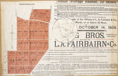
Map, Greystones Estate Land Sale 1909
... Land Sales...Land Sales Bacchus Marsh... Land Sales Bacchus Marsh Greystones Estate Bacchus Marsh Molesworth R. ...This map was produced sometime around mid 1909 to advertise portions of land from the Greystones Estate for sale by public tender. The selling agents were Young Brothers of Horsham and L.A. Fairbairn of Bacchus Marsh and Melbourne. The seller was Molesworth R. Greene who was a pioneer pastoralist in the Bacchus Marsh area and had also acquired other properties in Victoria and interstate. Molesworth Greene died in 1916 so this sale came towards the end of his life. A total of 4,176 acres was offered for sale in multiple lots. Successful tenderers could buy single or multiple lots. The results of the sale were reported in the Bacchus Marsh Express newspaper on the 16th October 1909, page 3. At the sale a total of 3, 420 acres was sold. A single page paper map showing portions of land for sale from the Greystones Estate near Bacchus Marsh. The map includes extensive details about the property, number of allotments for sale, terms and conditions of the sale and prices. The map includes an inserted reference map showing the location of the property in relation to Melbourne, Geelong, Ballarat and Castlemaine. The top of the map appears to be missing resulting in some loss of the text. The sale notice in the Bacchus Marsh Express of 10 July, 1909, page 3, column 1 appears to duplicate the text overall in the auction plan. Based on this the missing text is likely to be: "Important Subdivisional Sale 'Of Portion of One of the Best and Most Favourably known Estates IN THE RENOWNED BACCHUS MARSH DISTRICT. And situated only six miles from that prosperous township, two miles from Rowsley, and three miles from Parwan, all Railway towns, connected with the Estate by metal roads." Scale: 20 chains to 1 inch The map is pasted into a bound volume containing 76 maps or plans in total. bacchus marsh victoria maps, land sales, land sales bacchus marsh, greystones estate bacchus marsh, molesworth r. green 1827-1916, land sales rowsley -
 Bacchus Marsh & District Historical Society
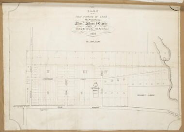
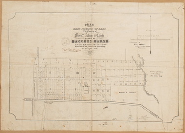
Map, Atkins and Clarke Land Sale situate at Bacchus Marsh 1856 Copy 2
... Land Sales...Land Sales Bacchus Marsh... Land Sales Bacchus Marsh Manor House Bacchus Marsh Crook Family Bacchus Marsh Plan of the first portion of land. ...This plan of land allotments for sale indicates the property once owned by the Bacchus family in and around the township area of Bacchus Marsh. The Bacchus family sold their property in Bacchus Marsh to John Atkins and Robert Nalder Clarke in March 1851. Atkins and Clarke kept the property for a number of years until April 1856 when these allotments were put up for sale.This plan is almost identical to another copy held by the Bacchus Marsh and District Historical Society, VC Record 707, BMDHS collection). This plan, VC Record 452 Copy 2, contains a less detail than than VC Record 707 Copy 1. For example the selling agents and the surveyor who created the plan are not indicated on this copy of the plan. This copy of the plan does indicate the name Crook Street on the map. As the Crook family were the buyers of the Manor House property and surrounding land from Atkins and Clarke in 1856 it suggests that this copy is a later one of the earlier version. It is unlikely that the Crook family would have had the adjacent street named after them prior to purchasing the house and property. This is a very early land sales plan for the township of Bacchus Marsh and it therefore provides some clues as to how the early urban development of the township took place. Upon seeing the map in 1911 Bacchus Marsh Express newspaper editor Christopher Crisp wrote "The sale appears to have created the present township, which had a nucleus in earlier times further east", Express, 30 September, 1911, page 3. A single page paper map showing a portions of land available for sale in Bacchus Marsh in 1856. The subdivided land shown was owned by John Atkins and Robert Nalder Clarke, but previously owned by the Bacchus Family and was in and around their Manor House (Mansion) property in Bacchus Marsh.There are 5 portions of land further divided into numerous small portions. The land for sale is bounded by the present day streets of Main Street, Young Street, McFarland Street, Morton Streets, Crook Street, and part of the eastern section extends to the Lerderderg River. Scale: 4 chains to 1 inch. The map is pasted into a bound volume containing 76 maps or plans in total. High resolution digital image stored on BMDHS computer network. Plan of the first portion of land. The property of Messers Atkins and Clarke situate at Bacchus Marsh.land sales, land sales bacchus marsh, manor house bacchus marsh, crook family bacchus marsh -
 Bacchus Marsh & District Historical Society
Map - Land Sales Plan, Broadlands Estate, Bacchus Marsh, 1916
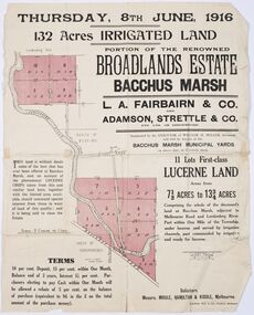
... ...Land Sales Bacchus Marsh...This land sales map was produced by real estate agents for an auction of part of a property near Bacchus Marsh known as the Broadlands Estate. 132 acres of irrigated land in 11 separate lots was to be auctioned on the 8th of June 1916. ...The Broadlands Estate was just over 2,000 acres at its its peak size and was a significant holding of land in the Bacchus Marsh district. Broadlands Estate Bacchus Marsh Land Sales Bacchus Marsh Farms Bacchus Marsh Henry Miller 1809-1888 Paper printed land sales map Broadlands Estate, Bacchus Marsh Map Land Sales Plan ...This land sales map was produced by real estate agents for an auction of part of a property near Bacchus Marsh known as the Broadlands Estate. 132 acres of irrigated land in 11 separate lots was to be auctioned on the 8th of June 1916. On the 27 May 1916, nine of the 11 eleven lots were withdrawn from sale. The reason stated was due to "road and severance difficulties", according to a notice in the Bacchus Marsh Express newspaper on 27 May, 1916, page.2. When the sale took place on 8th June the two lots were passed in but the local newspaper reported they were expected to be sold privately, see Express, 17 June, 1916, page. 2. The Broadlands Estate was owned by the Miller family whose father Henry Miller, 1809-1888, was a politician and an immensely wealthy financier in Victoria.A typical example of a land sale map of this era. The Broadlands Estate was just over 2,000 acres at its its peak size and was a significant holding of land in the Bacchus Marsh district. Paper printed land sales mapbroadlands estate bacchus marsh, land sales bacchus marsh, farms bacchus marsh, henry miller 1809-1888 -
 Bacchus Marsh & District Historical Society
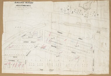
Map, Gaynor Street Land Sales, Maddingley, circa 1880s-1890s
... ...Land Sales Bacchus Marsh... Bacchus Marsh Land Sales Maddingley A single page paper map showing land allotments for sale in the Maddingley area of Bacchus Marsh. ...This map was produced for a major sale of land in the Maddingley area of Bacchus Marsh. The precise date of the sale has not been determined. Features present on the map such as the Bacchus Marsh Railway Station indicate the land sale must have taken place some time after 1887 when the Railway Station opened. A single page paper map showing land allotments for sale in the Maddingley area of Bacchus Marsh. Locations shown include Gaynor Street, Maddingley Road South, Parwan Road, Mitchem Street, Typpynge Street, Finn Street and East Maddingley Road. . The map is pasted into a bound volume containing 76 maps or plans in total. High resolution digital image stored on BMDHS computer network. bacchus marsh victoria maps, maddingley victoria maps, land use, maddingley victoria history, land sales bacchus marsh, land sales maddingley -
 Bacchus Marsh & District Historical Society
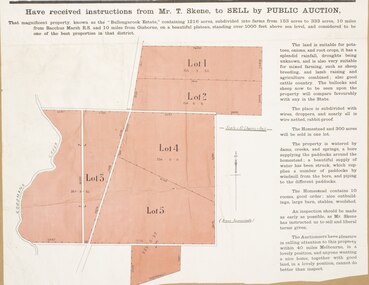
Map, Bullengarook Estate Property Sale. 1911
... Land Sales Bacchus Marsh...It was later leased by Thomas Skene to a Mr Coutts in 1915 and ultimately and at a later stage the property was sold by the Skene family. Land Sales Bacchus Marsh Bullengarook Land Sales Bullengarook Estate Bullengarook Vic History A single page paper map showing land allotments for sale from the Bullengarook Estate. ...Bullengarook is a locality located 19 kilometers north of Bacchus Marsh. Pastoral leases for European colonists were granted to people for this area from around the 1840s.The Bullengarook Estate was part of these early pastoral holdings. By the 1900s the property had been owned by the Skene family for a number of years. In early 1911 the property then consisting of 300 acres and the homestead upon it was offered for sale in one lot. It appears however that the sale of the property did not go through in 1911. It was later leased by Thomas Skene to a Mr Coutts in 1915 and ultimately and at a later stage the property was sold by the Skene family.A single page paper map showing land allotments for sale from the Bullengarook Estate. The map is pasted into a bound volume containing 76 maps or plans in total. High resolution digital image stored on BMDHS computer network. land sales bacchus marsh, bullengarook land sales, bullengarook estate, bullengarook vic history -
 Bacchus Marsh & District Historical Society
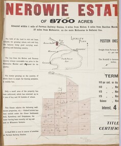
Map, Nerowie Estate Land Sale 1910
... Land Sales Parwan...Land Sales Bacchus Marsh...Bacchus Marsh & District Historical Society Lerderderg Library Main Street Bacchus Marsh The Nerowie Estate was a large rural property of 8,700 acres (3520 hectares) near the locality of Parwan only a few kilometers east of Bacchus Marsh. It had once formed a large part of the land owned by the pioneering Staughton family. Nerowie Estate Parwan Land Sales ...The Nerowie Estate was a large rural property of 8,700 acres (3520 hectares) near the locality of Parwan only a few kilometers east of Bacchus Marsh. It had once formed a large part of the land owned by the pioneering Staughton family.A single page paper map showing the land offered for sale from the Nerowie Estate at Parwan near Bacchus Marsh in 1910. The map is pasted into a bound volume containing 76 maps or plans in total. High resolution digital image stored on BMDHS computer network. nerowie estate parwan, land sales parwan, land sales bacchus marsh, staughton family bacchus marsh -
 Bacchus Marsh & District Historical Society
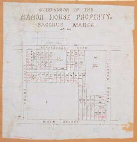
Map, Subdivision of the Manor House Property Bacchus Marsh c.1908
... ...Land Sales Bacchus Marsh...This land sales plan shows allotments of land offered for sale in the inner township area of Bacchus Marsh in 1908. ...Bacchus Marsh & District Historical Society Lerderderg Library Main Street Bacchus Marsh This land sales plan shows allotments of land offered for sale in the inner township area of Bacchus Marsh in 1908. ...This land sales plan shows allotments of land offered for sale in the inner township area of Bacchus Marsh in 1908. The land put up for sale was from the estate of the late Mr and Mrs J.E. Crook. That being James Elijah Crook and his wife Harriet, (nee Athorn). The Crooks had been resident in Bacchus Marsh since the 1840s and were prominent members of the community. They were prominent in the business, social and civic affairs of the town and district. In the 1850s the Crooks acquired the Manor House and nearby land once owned by the Bacchus family. James Crook died in 1889. When Harriet Crook died in February 1908 their estate was offered for sale. This included the large stone home known as the Manor House and various parcels of land including around 50 allotments of land near the Manor House, bounded by Young, Lerderderg, Crook and Main Streets. Most of these allotments of land were sold in October 1908. The Manor House itself was passed in at the sale and continued to be owned by the Crook family for several decades after 1908.A single page map on a single page of a bound volume of maps. The map shows portions of land for sale from the subdivision of the Manor House property in Bacchus Marsh in 1908. The names of most of the buyers of the portions of land have been hand-written into the various allotments they purchased. The maps are pasted into a bound volume containing 76 maps or plans in total. High resolution digital image stored on BMDHS computer network. bacchus marsh victoria maps, land sales bacchus marsh, manor house bacchus marsh, crook family bacchus marsh -
 Bacchus Marsh & District Historical Society
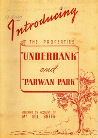
Booklet, Introducing the Properties Underbank and Parwan Park offering on account of Mr Sol Green
... ...Land Sales Bacchus Marsh...Bacchus Marsh & District Historical Society Lerderderg Library Main Street Bacchus Marsh Solomon Green 1868-1948 Bookmakers Parwan Park Underbank Stud Land Sales Bacchus Marsh Solomon (Sol) Green was a major bookmaker, businessman, real estate investor, racehorse owner and trainer, and philanthropist. ...Solomon (Sol) Green was a major bookmaker, businessman, real estate investor, racehorse owner and trainer, and philanthropist. His connection to Bacchus Marsh was through his ownership of the Underbank Stud property which he purchased in 1924. He also owned the Parwan Park property for some time. Both of these properties were put up for sale in 1947 just a year before the death of Sol Green in 1948.Stapled printed softcover booklet. 20 pages. 200mm x 290mm. Facsimile reproduction of a real estate booklet originally produced in 1947 by Sands and McDougall Pty Ltd for sale of the Underbank and Parwan Park properties in Bacchus Marsh. Facsimile reprint of original publication. Date of reprint copy c.2022. Original copy, printed 1947, is also held by Bacchus Marsh and District Historical Society. BMDHS Location: AR/SU4non-fictionSolomon (Sol) Green was a major bookmaker, businessman, real estate investor, racehorse owner and trainer, and philanthropist. His connection to Bacchus Marsh was through his ownership of the Underbank Stud property which he purchased in 1924. He also owned the Parwan Park property for some time. Both of these properties were put up for sale in 1947 just a year before the death of Sol Green in 1948. solomon green 1868-1948, bookmakers, parwan park, underbank stud, land sales bacchus marsh -
 Bacchus Marsh & District Historical Society
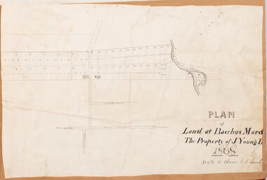
Map, Plan of Land at Bacchus Marsh, the Property of James Young, 1868
... Land Sales Bacchus Marsh... in the early colonial period of Bacchus Marsh. Land Sales Bacchus Marsh Bacchus Marsh Victoria Maps James Young 1816-1871 Masons Lane Bacchus Marsh Land Sales A single page paper map showing 38 blocks of land for sale in 1868 in the vicinity of Masons Lane Bacchus Marsh. ...James Young was a prominent businessman, land owner and public figure in the early colonial period of Bacchus Marsh. In February 1868 he offered for sale through the agent W. Anderson 38 blocks of land which ran from the Lerderderg RIver westwards beyond Gisborne Road in the vicinity of the present day Masons Land. The land for sale was described as, 'unsurpassed Agricultural Land, in the immediate vicinity of Bacchus Marsh, varying in size from 2 to 12 acres each'. The sale notice in the Bacchus Marsh Express of 1st February 1868 page 2, also noted that, ' Plans can be seen at Mr. Young's Border Mills Store, and at the Border Inn'. One of the largest and most important land sales in the early colonial period of Bacchus Marsh.A single page paper map showing 38 blocks of land for sale in 1868 in the vicinity of Masons Lane Bacchus Marsh. Scale 11 chains to 1 inch. The map is pasted into a bound volume containing 76 maps or plans in total. High resolution digital image stored on BMDHS computer network. land sales bacchus marsh, bacchus marsh victoria maps, james young 1816-1871, masons lane bacchus marsh land sales -
![Map, Plan of Subdivision of Crown Portion 23 & parts 24-25, Parish of Korkuperrimul [1900s?]](/media/collectors/5e461d8021ea67224c82f2a1/items/675fe058304668462205d4fb/item-media/675fe0ef304668462205d7d6/item-fit-380x285.jpg?cb=6) Bacchus Marsh & District Historical Society
Bacchus Marsh & District Historical SocietyMap, Plan of Subdivision of Crown Portion 23 & parts 24-25, Parish of Korkuperrimul [1900s?]
... Land Sales Bacchus Marsh...Bacchus Marsh & District Historical Society Lerderderg Library Main Street Bacchus Marsh The Parish of Korkuperrimul includes a significant section of the township of Bacchus Marsh and extends in western and northern directions from the township area. The date of the subdivision indicated on this plan has not been established. The engineer's stamp on the drawing shows the firm of Muntz and Muntz who were operating under that name in the early part of the 20th century. Land Sales ...The Parish of Korkuperrimul includes a significant section of the township of Bacchus Marsh and extends in western and northern directions from the township area. The date of the subdivision indicated on this plan has not been established. The engineer's stamp on the drawing shows the firm of Muntz and Muntz who were operating under that name in the early part of the 20th century.A single page paper map showing 20 blocks of land for sale in the Parish of Korkuperrimul. Scale 100 feet to 1 inch. The map is pasted into a bound volume containing 76 maps or plans in total. High resolution digital image stored on BMDHS computer network. Stamped: 'Muntz & Muntz Civil Engineers, Architects & Surveyors, Trustees Chambers ?? Cor Collins Street and Bank Placeland sales bacchus marsh, bacchus marsh victoria maps, land sales korkuperrimul parish -
 Bacchus Marsh & District Historical Society
Map, Gaynor Street Area Land Sales, Maddingley, 1888
... ...Land Sales Bacchus Marsh... Bacchus Marsh Land Sales Maddingley A single page paper map showing land allotments for sale in the Maddingley area of Bacchus Marsh. ...This map was produced for a major sale of land in the Maddingley area of Bacchus Marsh in 1888. The sale was conducted by two firms from Melbourne, Carney and Kelly 12 Swanston Street Melbourne. and 'Richardson, Kerr & Co. 40 Flinders Lane Melbourne. 136 blocks were for sale.A single page paper map showing land allotments for sale in the Maddingley area of Bacchus Marsh. Locations shown include Gaynor Street, Maddingley Road South, Parwan Road, Mitchem Street, Typpynge Street, Finn Street and East Maddingley Road. . The map is pasted into a bound volume containing 76 maps or plans in total. High resolution digital image stored on BMDHS computer network. bacchus marsh victoria maps, maddingley victoria maps, land use, maddingley victoria history, land sales bacchus marsh, land sales maddingley -
 Bacchus Marsh & District Historical Society
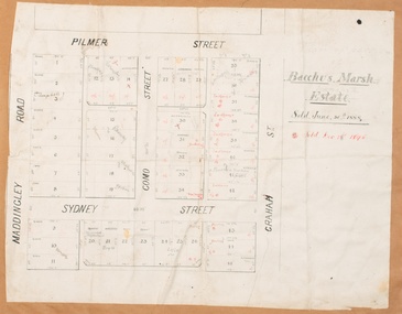
Map, Bacchus Marsh Estate sold 30th June 1888 and sold 28 December 1895
... ...Land Sales Bacchus Marsh...Blocks of land in this area of Bacchus Marsh were sold in lots between 1888 and the late 1890s. This map shows sales made in 1888 and 1895....Bacchus Marsh & District Historical Society Lerderderg Library Main Street Bacchus Marsh Blocks of land in this area of Bacchus Marsh were sold in lots between 1888 and the late 1890s. This map shows sales ...Blocks of land in this area of Bacchus Marsh were sold in lots between 1888 and the late 1890s. This map shows sales made in 1888 and 1895.Single page map showing allotments of land bounded by Pilmer Street, Graham Street, Sydney Street and Maddingley Road (Grant Street) in Bacchus Marsh.The area is dissected by Como Street down the central area. 43 blocks of land are shown with the names of buyers or sellers in 1888 written in black in. Buyers or sellers for December 1895 are written in red ink. Part of a set of maps which are pasted into a bound volume containing 76 maps or plans in total. High resolution digital image stored on BMDHS computer network. bacchus marsh victoria maps, land sales bacchus marsh, pilmer street bacchus marsh, graham street bacchus marsh, sydney street bacchus marsh, como street bacchus marsh, maddingley road bacchus marsh, grant street bacchus marsh -
![Map, Liquidator's sale, 1896. [Woolpack Estate, Bacchus Marsh]](/media/collectors/5e461d8021ea67224c82f2a1/items/6779ee97032b72846b5995f2/item-media/6779ef33032b72846b599b30/item-fit-380x285.jpg?cb=6) Bacchus Marsh & District Historical Society
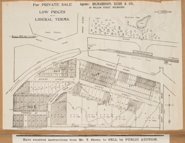
Bacchus Marsh & District Historical SocietyMap, Liquidator's sale, 1896. [Woolpack Estate, Bacchus Marsh]
... Land Sales Bacchus Marsh...land were sold for higher than expected prices and most of the buyers were people from the town and district of Bacchus Marsh. The map includes various details about the land which is described on the map as an "important sale of rich alluvial irrigable flat land in the Bacchus Marsh Valley, and other properties". The auction was conducted by the local agents W. Anderson and Bence in conjunction with Pearce Brothers also of Bacchus Marsh. Land Sales ...The Woolpack Estate was an area of land owned by various landowners in the Bacchus Marsh area since the early Colonial period of the 1840s. The area was located on the eastern side of the Bacchus Marsh township about 7 kilometers from the town. The Lerderderg River ran through part of the land and so did the Melbourne to Ballarat Road. The historic Woolpack Inn associated with James Crook was also located on this land. By 1896 150 acres of this land was under the control of liquidators for the Federal Bank of Australasia who instructed that the land be sub-divided and sold in lots by public auction. A successful sale was held on 24 June 1896. Most of the blocks of land were sold for higher than expected prices and most of the buyers were people from the town and district of Bacchus Marsh. The map includes various details about the land which is described on the map as an "important sale of rich alluvial irrigable flat land in the Bacchus Marsh Valley, and other properties". The auction was conducted by the local agents W. Anderson and Bence in conjunction with Pearce Brothers also of Bacchus Marsh.A single page paper map showing a plan of 150 acres of land from the Woolpack Estate to be sold in various lots in June 1896. Also shown on the map are lots for sale at Robinson's Farm on Coimadai Creek and allotments near Bacchus Marsh railway station, including lots on Government Road (East Maddingley Road), View Street and Government Road (Parwan Road). No scale provided. The map is pasted into a bound volume containing 76 maps or plans in total. High resolution digital image stored on BMDHS computer network. land sales bacchus marsh, bacchus marsh victoria maps, woolpack estate bacchus marsh victoria -
![Map, Plan of Town Allotments Bacchus Marsh [1873]](/media/collectors/5e461d8021ea67224c82f2a1/items/677a8ee7ab7bb47995c5573f/item-media/677a8fdeab7bb47995c55b56/item-fit-380x285.jpg?cb=6) Bacchus Marsh & District Historical Society
Bacchus Marsh & District Historical SocietyMap, Plan of Town Allotments Bacchus Marsh [1873]
... Land Sales Bacchus Marsh...land in the inner urban area of the Bacchus Marsh township. This subdivision lead to the continuing residential and commercial development of the township of Bacchus Marsh in the later part of the 19th century. The location of two well known demolished public structures, the Free Gardeners Hall in Gell Street, and the Old Mechanics Institute Hall (aka the Buffs Hall), on the corner of Young and Bennett Streets, are also shown on this map. Land Sales ...James Young was a prominent businessman, land owner and public figure in the early colonial period of Bacchus Marsh. After his death in 1871 land remaining from his estate in Bacchus Marsh was sold at auction in 1873. The sale of his estate included the substantial stone residence in Bennett Street which later became known as 'Stone Villa'. The sale of his land in 1873 was conducted by local auctioneer James Crook. 29 allotments were advertised for sale, although the plan for the sale indicated 30 allotments. The sale notice in the Bacchus Marsh Express of 11 October 1873 noted that the allotments were " in the very centre and heart of the most populous and business portion of the township, at the same time being the only remaining portion of the business block available for purchase by public sale, which fact intending purchasers should not lose sight of, as the opportunity cannot occur again". The designation of a new street, 'Bennett Street', shown on the plan, is also indicated in the advertising, "In reference to the main street frontages, opposite the Border Flour Mills. The Auctioneer would also direct attention to the plan, showing the formation of a new thorough fare (Bennett street) leading from Young street into Gell street, thus opening up the township on the high, more healthy, and commanding position so much to be desired for private dwellings".An important cartographic document which indicates an early major subdivision of land in the inner urban area of the Bacchus Marsh township. This subdivision lead to the continuing residential and commercial development of the township of Bacchus Marsh in the later part of the 19th century. The location of two well known demolished public structures, the Free Gardeners Hall in Gell Street, and the Old Mechanics Institute Hall (aka the Buffs Hall), on the corner of Young and Bennett Streets, are also shown on this map.A single page paper map showing 30 blocks of land for sale around 1873 in the vicinity of Bennett Street and Lerderderg Street. Described in contemorary sources as a 'lithographed copy'. No scale is indicated. The map is pasted into a bound volume containing 76 maps or plans in total. High resolution digital image stored on BMDHS computer network. land sales bacchus marsh, bacchus marsh victoria maps, james young 1816-1871, bacchus marsh roads and streets, bennett street bacchus marsh -
 Bacchus Marsh & District Historical Society
Map, Plan of the property of Messers Atkins and Clarke to be sold at the Mansion, Bacchus Marsh 19th April 1856. Copy 1
... Land Sales...Manor House Bacchus Marsh...Bacchus Marsh and it therefore provides some clues as to how the early urban development of the township took place. Upon seeing the map in 1911 Bacchus Marsh Express newspaper editor Christopher Crisp wrote "The sale appears to have created the present township, which had a nucleus in earlier times further east", Express, 30 September, 1911, page 3. Bacchus Marsh Victoria Maps Bacchus Family Land Sales ...This plan of land allotments for sale indicates the property once owned by the Bacchus family in and around the township area of Bacchus Marsh. The Bacchus family sold their property in Bacchus Marsh to John Atkins and Robert Nalder Clarke in March 1851. Atkins and Clarke kept the property for a number of years until April 1856 when these allotments were put up for sale.This plan is almost identical to another copy held by the Bacchus Marsh and District Historical Society, VC Record 452, BMDHS collection). This plan, VC Record 707 Copy 1, contains a little more detail overall than VC Record 452 Copy 2, such as who did the survey work for the plan (R.C. Bagot) and who the selling agents were, (W.M. Tennent), and on the right side of the plan near the Lerderderg River is indicated the general area for a second parcel of land from this sale which is to be sold. There is also a compass illustration indicating north and south compass points.This is a very early land sales plan for the township of Bacchus Marsh and it therefore provides some clues as to how the early urban development of the township took place. Upon seeing the map in 1911 Bacchus Marsh Express newspaper editor Christopher Crisp wrote "The sale appears to have created the present township, which had a nucleus in earlier times further east", Express, 30 September, 1911, page 3.A single page paper plan showing allotments of land for sale. The subdivided land shown was owned by John Atkins and Robert Nalder Clarke, but previously owned by the Bacchus Family and was in and around their Manor House (Mansion) property in Bacchus Marsh.There are 5 portions of land further divided into numerous small portions. The land for sale is bounded by the present day streets of Main Street, Young Street, McFarland Street, Morton Streets, Crook Street, and part of the eastern section extends to the Lerderderg River. Scale: 8 chains to 1 inch The plan is pasted into a bound volume containing 76 maps or plans in total. BMDHS Loc: AR/B12/S4 Bacchus Marsh Township and Nearby Districts Maps Volume In-house Digital copies: BMDHS, Computer Network: Maps\Bacchus Marsh Township and Nearby Districts Maps VolumeHeading: Plan of the first portion of land. The property of Messers Atkins and Clarke situate at Bacchus Marsh. To be sold by W.M. Tennent & Co. at the Mansion on the Ground on Saturday the 19th April 1856. Below heading: Jas Ferguson, Lithographer On upper right side: Subdivided by R.C. Bagot London and Liverpool Chambers, Melbourne. 'Thos Taubman'. Post Office Stamp: BACCHUS MARSH VICTORIA MY 6, 63bacchus marsh victoria maps, bacchus family, land sales, manor house bacchus marsh -
 Bacchus Marsh & District Historical Society
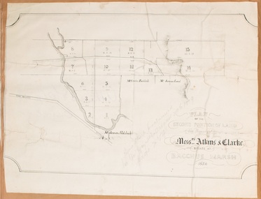
Map, Plan of the second portion of the property of Messers Atkins and Clarke situate at Bacchus Marsh 1856
... Land Sales...Manor House Bacchus Marsh...Bacchus Marsh & District Historical Society Lerderderg Library Main Street Bacchus Marsh This plan of land allotments for sale indicates part of the property once owned by the Bacchus family in and around the township area of Bacchus Marsh. The Bacchus family sold their property in Bacchus Marsh to John Aitkins and Robert Nalder Clarke in March 1851. Aitkins and Clarke kept the property for a number of years until April 1856 when these allotments were put up for sale. This is a very early land sales ...This plan of land allotments for sale indicates part of the property once owned by the Bacchus family in and around the township area of Bacchus Marsh. The Bacchus family sold their property in Bacchus Marsh to John Aitkins and Robert Nalder Clarke in March 1851. Aitkins and Clarke kept the property for a number of years until April 1856 when these allotments were put up for sale.This is a very early land sales plan for agricultural land close to the township of Bacchus Marsh. It therefore provides some clues as to how the early urban development of the township and agricultural development of the nearby area took place. Upon seeing the map in 1911 Bacchus Marsh Express newspaper editor Christopher Crisp wrote "The sale appears to have created the present township, which had a nucleus in earlier times further east", Express, 30 September, 1911, page 3.A single page paper plan showing allotments of land for sale. The subdivided land shown was owned by John Aitkins and Robert Nalder Clarke, but previously owned by the Bacchus Family and was in and around their Manor House (Mansion) property in Bacchus Marsh. This plan shows allotments in the second portion of land to be sold which was located east of the Manor House on the eastern side of the Lerderderg River. The land for sale was made up of 15 allotments. The plan is pasted into a bound volume containing 76 maps or plans in total. BMDHS Loc: AR/B12/S4 Bacchus Marsh Township and Nearby Districts Maps Volume In-house Digital copies: BMDHS, Computer Network: Maps\Bacchus Marsh Township and Nearby Districts Maps Volumebacchus marsh victoria maps, bacchus family, land sales, manor house bacchus marsh -
 Bacchus Marsh & District Historical Society
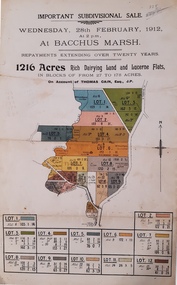
Map, Important Subdivisional Sale at Bacchus Marsh, Wednesday 28 February, 1912, 1912
... Bacchus Marsh & District Historical Society Lerderderg Library Main Street Bacchus Marsh Land Sales Thomas Cain Landholders In the later 19th century and early 20th centuries Thomas Cain was a major farmer in the Bacchus Marsh district and a significant participant in community life and affairs. ...In the later 19th century and early 20th centuries Thomas Cain was a major farmer in the Bacchus Marsh district and a significant participant in community life and affairs. The sale of some of his most significant properties towards the end of his life generated wide interest in Bacchus Marsh and beyond.Paper. 33cm x 21cmnon-fictionIn the later 19th century and early 20th centuries Thomas Cain was a major farmer in the Bacchus Marsh district and a significant participant in community life and affairs. The sale of some of his most significant properties towards the end of his life generated wide interest in Bacchus Marsh and beyond.land sales, thomas cain, landholders -
 Bacchus Marsh & District Historical Society
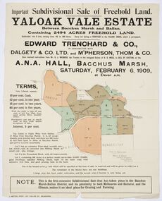
Map, Edward Trenchard & Co, Important Subdivisional Sale of Freehold Land Yaloak Vale Estate
... Bacchus Marsh & District Historical Society Lerderderg Library Main Street Bacchus Marsh This subdivisional sale of land took place in Bacchus Marsh on the 6th February 1909. Most of the lots were acquired by Mr. Albert Miller who was already one of the largest land owners in the district of Bacchus Marsh. Details of the sale were reported in the Bacchus Marsh Express 13 February, 1909, page 4. A good example of land sale maps and advertising material for the district of Bacchus Marsh. Important Subdivisional Sale of Freehold Land Yaloak Vale Estate Land sales ...A land sales map and advertisementLand sales advertising poster with map indicating specific lots of land for sale.A land sales map and advertisementimportant subdivisional sale of freehold land yaloak vale estate, land sales -
 Bacchus Marsh & District Historical Society
Map, Bacchus Marsh Township and Nearby Districts Maps Volume
... Bacchus Marsh & District Historical Society Lerderderg Library Main Street Bacchus Marsh This volume of maps is believed to have been compiled by staff at the Shire of Bacchus Marsh and was presumably used to inform and assist Shire staff and Councillors in the carriage of their duties. This collection of maps are significant due to their rarity as many of them are unique maps made for local purposes in the Bacchus Marsh region. They are also of strong research value containing a wide variety of information including landholders, land sales ...This volume of maps is believed to have been compiled by staff at the Shire of Bacchus Marsh and was presumably used to inform and assist Shire staff and Councillors in the carriage of their duties.This collection of maps are significant due to their rarity as many of them are unique maps made for local purposes in the Bacchus Marsh region. They are also of strong research value containing a wide variety of information including landholders, land sales, infrastructure, such as roads, bridges, public, commercial and private buildings, houses, land use, and geographic features over multiple decades from the late nineteen century into the middle part of the twentieth century.One bound volume of maps comprising cadastral maps, (indicating property owners and land boundaries), land plans and real estate auction plans and advertising material, and other maps indicating major infrastructure like proposed roads and irrigation areas. Most of the maps and plans are of Bacchus Marsh and nearby areas but some maps are of nearby towns such as Melton, Ballan and Blackwood. The volume comprises 52 pages. Most pages have a single map or plan pasted onto it but some contain 2 or 3 different maps. There are 81 maps in total. Map 1 Liquidators Sale 1896. Map 2. Woodside Estate Sale 1913. maps, maps bacchus marsh, maps bacchus marsh region -
 Bacchus Marsh & District Historical Society
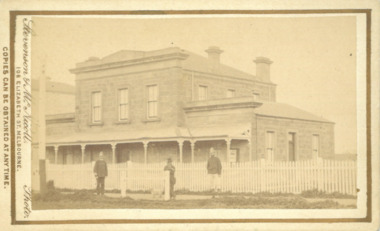
Photograph, Court House Main Street Bacchus Marsh 1883
... Bacchus Marsh was built in 1858 using local sandstone. It opened in 1859. It has been used for jury trials, a Court of Petty Sessions, a County Court and a Crown Land sales office. ...Bacchus Marsh & District Historical Society Lerderderg Library Main Street Bacchus Marsh The Court House in Main Street Bacchus Marsh was built in 1858 using local sandstone. It opened in 1859. It has been used for jury trials, a Court of Petty Sessions, a County Court and a Crown Land sales ...The Court House in Main Street Bacchus Marsh was built in 1858 using local sandstone. It opened in 1859. It has been used for jury trials, a Court of Petty Sessions, a County Court and a Crown Land sales office. Other uses included an office for the Registrar of Births and Deaths, a Dairy Inspectors office from 1863-1865, and as meeting rooms for the Bacchus Marsh Roads Board, a forerunner of the Shire Council. It was also used by the Bacchus Marsh Shire Council for its offices until at least 1884. In more recent years it has functioned as a Magistrates Court with weekly court sessions. Small sepia unframed photograph on card with gold border framing photograph. Housed in the album, 'Photographs of Bacchus Marsh and District in 1883 by Stevenson and McNicoll'. The view of the Court House building is seen from the northern side of Main Street looking south or south-east. Three men are standing in the street in front of the building. The men on the left and the right wearing police helmets appear to be police officers. The man in the middle is in civilian clothes and might be an officer or employee of the Court House. He has his dog with him. A white picket fence runs along the front of the building. The front courtyard of the building has been renovated since, but this building still operates as a court house.On the front: Stevenson & McNicoll. Photo. 108 Elizabeth St. Melbourne. COPIES CAN BE OBTAINED AT ANY TIME. On the back: LIGHT & TRUTH inscribed on a banner surmounted by a representation of the rising sun. Copies of this Portrait can be had at any time by sending the Name and Post Office Money Order or Stamps for the amount of order to STEVENSON & McNICOLL LATE BENSON & STEVENSON, Photographers. 108 Elizabeth Street, MELBOURNE. stevenson and mcnicoll 1883 photographs of bacchus marsh and district, courthouses, bacchus marsh court house -
 Bacchus Marsh & District Historical Society
Map, Lerderderg Park Lands sale plan. 1911
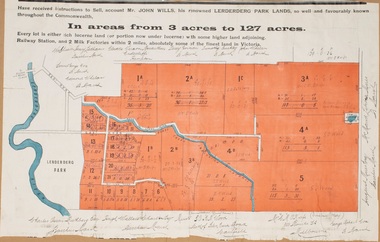
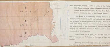
... Bacchus Marsh Express newspaper through July of 1911. The property was situated only a few kilometers from the township of Bacchus Marsh. The agents for the sale were L. A. Fairbairn & Co. Lerderderg Park Estate was a significant and early colonial property in the Bacchus Marsh area. This plan provides details about the first time the property was subdivided for sale. It is therefore documents an important moment in the history of this property and the broader trend of the subdivision of older and larger properties in the district. Bacchus Marsh Victoria Maps Land Sales ...This plan was for the sale of parcels of land from the Lerderderg Park Estate property in 1911. Advertising for the sale appeared in the Bacchus Marsh Express newspaper through July of 1911. The property was situated only a few kilometers from the township of Bacchus Marsh. The agents for the sale were L. A. Fairbairn & Co.Lerderderg Park Estate was a significant and early colonial property in the Bacchus Marsh area. This plan provides details about the first time the property was subdivided for sale. It is therefore documents an important moment in the history of this property and the broader trend of the subdivision of older and larger properties in the district.A single page paper plan showing allotments of land for sale from the Lerderderg Park property owned by John Wills. The parcels of land for sale are coloured in red.The Lerderderg River and Pyke's Creek Irigation Channel shown on the plan are in blue ink. The rest of the plan is a dark cream or beige colur with the text in black ink. The plan has been extensively annotated with hand-written notes indicating the names of people who purchased the various parcels of lands and the prices paid for those lands. Part of the top of the plan containing some text appears to be missing. The plan is pasted into a bound volume containing 76 maps or plans in total. Top: Have received instructions to Sell, account Mr John Wills, his renowned LERDERDERG PARK LANDS, so well and favourably known throughout the Commonwealth. In areas from 3 acres to 1276 acres. Every lot is either rich lucerne land (or portion now under lucerne) with some higher land adjoining Railway Station, and 2 Milk factories within 2 miles, absolutely the finest land in Victoria. Bottom: THIS IS THE FIRST SUBDIVISIONAL SALE of Rich Flats in Bacchus Marsh since the Pyke's Creek Scheme, and every lot is commanded by it. Only 32 miles from Melbourne.bacchus marsh victoria maps, land sales, lerderderg park estate, land subdivision -
 Bacchus Marsh & District Historical Society
Map, Pentland Hills Estate Land Sale 1904
... Peter Grant had worked and farmed in the Myrniong area for many years and had also been a Councillor on the Bacchus Marsh Shire for a number of terms. A property sales report in the Express newspaper recorded that the land for sale comprised 500 acres of the old Pentland Hills Estate. ...Bacchus Marsh & District Historical Society Lerderderg Library Main Street Bacchus Marsh The Pentland Hills Estate property shown in this auction plan was put up for sale in 1904. It was a deceased estate sale. The property had been owned by Peter Grant who died in 1899. Peter Grant had worked and farmed in the Myrniong area for many years and had also been a Councillor on the Bacchus Marsh Shire for a number of terms. A property sales report in the Express newspaper recorded that the land ...The Pentland Hills Estate property shown in this auction plan was put up for sale in 1904. It was a deceased estate sale. The property had been owned by Peter Grant who died in 1899. Peter Grant had worked and farmed in the Myrniong area for many years and had also been a Councillor on the Bacchus Marsh Shire for a number of terms. A property sales report in the Express newspaper recorded that the land for sale comprised 500 acres of the old Pentland Hills Estate. It was subdivided into three lots, all of which were sold at good prices. Lot l, 212 acres was sold to Messrs Thomas and Robert Lidgett of Myrniong, at £11/15/ per acre, lot 2, 200 acres, to Mr David Robertson, of Bacchus Marsh, at £9 17/0 per acre, and lot 3, 38 acres, was sold to Mr James Norton, jun at £11 per acre. A single page paper map showing a portions of land available for sale from the Pentland Hills Estate near Bacchus Marsh.The name of the seller, Mrs Grant, can seen handwritten on this map and the buyers of the three portions for sale, Lidgett lot 1, Robertson lot 2 and Morton lot 3. Parts of the text are missing along the edges due to tearing or excessive trimming of the edges. The map is pasted into a bound volume containing 76 maps or plans in total. High resolution digital image stored on BMDHS computer network. Handwritten: Mrs Grant, Myrniong, Executrix in the deceased Estate of Mr. Peter Grant to sell by public auction.land sales, pentland hills maps, myrniong area land sales, pentland hills estate -
 Bacchus Marsh & District Historical Society
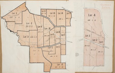
Map, Glenvale Estate and Glenmore Estate Land Sales 1909
... These two plans document another major sale of the land from the original Glenmore Estate including part of the estate which had become used for dairy farming and was at that time known as the Glenvale Estate. Bacchus Marsh Victoria Maps Glenvale Estate Property Glenvale Estate Land Sales Glenmore Estate Glenmore Station Two single page maps pasted together on a single page of a bound volume of maps. ...The two land auction plans shown in this record relate to the sale of land from the Glenmore Estate property. The Glenmore property was established by C.J. (Charles James) Griffith and James Moore around 1840. Moore sold his interest to Moelesworth Greene in 1848. Greene was the nephew of the other owner Charles Griffith who died in 1863. From around the 1870s onwards parts of the Estate were subdivided and put up for sale or lease. In subsequent decades more changes in ownership occurred. These two plans document another major sale of the land from the original Glenmore Estate including part of the estate which had become used for dairy farming and was at that time known as the Glenvale Estate. Two single page maps pasted together on a single page of a bound volume of maps. One map shows 15 separate lots of land for sale. The other map which has the words 'Glenvale Estate' at the top of the map shows 4 lots of land for sale. Both parcels of land were originally part of the Glenmore Estate a pastoral holding belonging to C.J. Griffith and James Moore which the began in the Rowsley area south west of Bacchus Marsh in the 1840s. The maps are pasted into a bound volume containing 76 maps or plans in total. High resolution digital image stored on BMDHS computer network. bacchus marsh victoria maps, glenvale estate property, glenvale estate land sales, glenmore estate, glenmore station