Showing 47 items matching "latitude"
-
 Flagstaff Hill Maritime Museum and Village
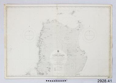
Document - Navigation Chart, Luzon Island : North of Latitude 16º 20' North
... Luzon Island : North of Latitude 16º 20' North...British Admiralty Navigation Chart - Luzon Island : North of Latitude 16º 20' North...Flagstaff Hill Maritime Museum and Village 89 Merri Street Warrnambool great-ocean-road warrnambool shipwrecked-coast flagstaff-hill flagstaff-hill-maritime-museum maritime-museum shipwreck-coast flagstaff-hill-maritime-village shipwrecked-artefact navigation chart british admiralty navigation chart british admiralty luzon island British Admiralty Navigation Chart - Luzon Island : North of Latitude 16º 20' North Luzon Island : North of Latitude 16º 20' North Document Navigation Chart ...British Admiralty Navigation Chart - Luzon Island : North of Latitude 16º 20' Northwarrnambool, shipwrecked-coast, flagstaff-hill, flagstaff-hill-maritime-museum, maritime-museum, shipwreck-coast, flagstaff-hill-maritime-village, shipwrecked-artefact, navigation chart, british admiralty navigation chart, british admiralty, luzon island -
 Flagstaff Hill Maritime Museum and Village
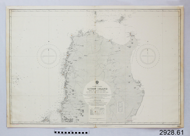
Document - Navigation Chart, Luzon Island, North of Latitude 16° 20' north
... Luzon Island, North of Latitude 16° 20' north...British Admiralty Navigation Chart - Phillippine Islands - Luzon Island, North of Latitude 16° 20' north...Flagstaff Hill Maritime Museum and Village 89 Merri Street Warrnambool great-ocean-road warrnambool shipwrecked-coast flagstaff-hill flagstaff-hill-maritime-museum maritime-museum shipwreck-coast flagstaff-hill-maritime-village shipwrecked-artefact navigation chart british admiralty navigation chart british admiralty luzon island British Admiralty Navigation Chart - Phillippine Islands - Luzon Island, North of Latitude 16° 20' north Luzon Island, North of Latitude 16° 20' north Document Navigation Chart ...British Admiralty Navigation Chart - Phillippine Islands - Luzon Island, North of Latitude 16° 20' northwarrnambool, shipwrecked-coast, flagstaff-hill, flagstaff-hill-maritime-museum, maritime-museum, shipwreck-coast, flagstaff-hill-maritime-village, shipwrecked-artefact, navigation chart, british admiralty navigation chart, british admiralty, luzon island -
 Federation University Historical Collection
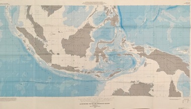
Map - Geological, U.S. Government Printing Office, Bathymetric Map of the Indonesian Region: Folio of the Indonesian Region Map I-875-A, 1974, 1974
... ...latitude...The area covered shows the islands and seas from Latitude 12 degree North to 16 degrees South and Longitude 90 degrees to 148 degrees. ...Longitude and Latitude are shown. Major / Capitol cities indicated. ...Various water features are also named. indonesia united nations economic commission department of state geological survey latitude longitude government of indonesia Longitude and Latitude are shown. ...Map was prepared on behalf of the Government of Indonesia, The United Nations Economic Commission for Asia and the Far East, the Agency for International Development and the U.S. Department of State in cooperation with the Geological Survey of Indonesia. The area covered shows the islands and seas from Latitude 12 degree North to 16 degrees South and Longitude 90 degrees to 148 degrees. Various water features are also named.Large map showing the Indonesian area - islands and seasLongitude and Latitude are shown. Major / Capitol cities indicated. Names of those responsible for the productionindonesia, united nations economic commission, department of state, geological survey, latitude, longitude, government of indonesia -
 Phillip Island and District Historical Society Inc.
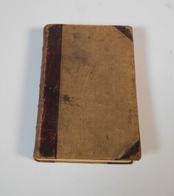
Book, JEANS, H.W, Navigation and nautical astronomy, the practical part, containing rules for finding the latitude and longitude, and the variation of the compass, with numerous examples, 1853
... Navigation and nautical astronomy, the practical part, containing rules for finding the latitude and longitude, and the variation of the compass, with numerous examples...Navigation and nautical astronomy, the practical part, containing rules for finding the latitude and longitude, and the variation of the compass, with numerous examples Book JEANS, H.W. ...Inscribed 'Jno. Cleeland, Melbourne'. Labelled 'Phillip Island Historical Society, Cleeland Bequest'. Pencilled drawing inside back cover, 'hope' & 'anchor'. -
 Bendigo Military Museum
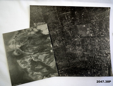
Photograph - AERIAL PHOTOGRAPHS WW2, 1942 - 1944
... Most images: Locations, including Latitude and Longitude marked on the back...Refer Cat No 215.9 for his service details. photography-photographs-military Aerial Most images: Locations, including Latitude and Longitude marked on the back 37 Aerial reconnaissance photographs of various locations over Timor and surrounding islands 1 Envelope: original container of photographs. ...Various reconnaissance photographs depicting targets in Timor for attack by the R.A.A.F. Items saved by Maurice Anthony BYRNE RAAF. Refer Cat No 215.9 for his service details.37 Aerial reconnaissance photographs of various locations over Timor and surrounding islands 1 Envelope: original container of photographs.Most images: Locations, including Latitude and Longitude marked on the backphotography-photographs-military, aerial -
 Whitehorse Historical Society Inc.
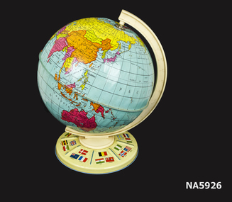
Education kit - World Globe, Chad Valley, Circa 1960
... - World globe on metal stand - Country flags on base - Rotates on plastic axis - Longitude and latitude lines...World globe - all countries Spins on axis Flags of the world shown on base Educational object World globe Geographic education Made in England Chad Valley - World globe on metal stand - Country flags on base - Rotates on plastic axis - Longitude and latitude lines Education kit World Globe Chad Valley ...World globe - all countries Spins on axis Flags of the world shown on base Educational object- World globe on metal stand - Country flags on base - Rotates on plastic axis - Longitude and latitude linesMade in England Chad Valleyworld globe, geographic education -
 Federation University Historical Collection
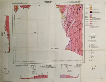
Map - Geological, Tallangatta, New South Wales: 1:250,000 Geological Series, SJ 55-3, 1966, 1966
... Scale of map, longitude and latitude, river names. "Tallangatta 1:250,00" written in black pen....There are 13 formation sections grouped into 9 - Quaternary, Tertiary, Middle Devonian, Lower to Middle Devonian, Lower Devonian, Upper Silurian, Silurian, Upper Ordovician and Ordovician. tallangatta new south wales geological survey topographical base snowy mountains hydro electrical authority department of lands snowy lease map department of mines quaternary tertiary middle devonian lower to middle devonian lower devonian uper siluran silurian upper ordovician ordovician Scale of map, longitude and latitude, river names. "Tallangatta 1:250,00" written in black pen. ...Compiled by the Geological Survey of N.S.W., Division of Regional Geology. Topographical base compiled from Snowy Mountains Hydro Electrical Authority, Department of Lands, County maps and Snowy Lease Map. Other sheet adjoin this map. There are 13 formation sections grouped into 9 - Quaternary, Tertiary, Middle Devonian, Lower to Middle Devonian, Lower Devonian, Upper Silurian, Silurian, Upper Ordovician and Ordovician.Large coloured map showing geological features, faults, bores, rivers and mineral deposits.Scale of map, longitude and latitude, river names. "Tallangatta 1:250,00" written in black pen.tallangatta, new south wales, geological survey, topographical base, snowy mountains hydro electrical authority, department of lands, snowy lease map, department of mines, quaternary, tertiary, middle devonian, lower to middle devonian, lower devonian, uper siluran, silurian, upper ordovician, ordovician -
 Mission to Seafarers Victoria
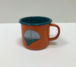
Souvenir - Cup, Margaret Woodward, 2015
... For a fortnight in May 2015, the Dome Gallery became an architectural large scale compass, with the circular floor marking the intersection of its latitude and longitude (37 º 49'21" S 144º 57'03"E). ...On one side it is decorated with a compass and a latitude and longitude; on the opposite side, a leaf, a QR code on the bottom takes you to the website....On one side it is decorated with a compass and a latitude and longitude; on the opposite side, a leaf, a QR code on the bottom takes you to the website. ...Margaret Woodward is a an artist and an an associate professor of design at Charles Sturt University. Artist statement: "The Sea is All Around us is a multi-layered event which creates a memorable experience for those visiting the Dome Gallery and the Mission to Seafarers in Melbourne’s Docklands. The event acknowledges and raises awareness of the often difficult and dangerous working lives and journeys of seafarers by making visible their role in transporting commodities, materials and objects to and from Australia’s shores. This installation at the Dome Gallery in the Mission to Seafarers in Melbourne’s Docklands marks the third stage of an ongoing research project which seeks to reveal the ‘social life’ of souvenirs. Beyond their representational role souvenirs also trigger intangible, affective qualities – reminders of journeys and places, new associations with tastes, sounds and people, and thereby becoming objects which focus and hold memories. This installation invites seafarers and visitors to participate in a global project which aims to witness sea journeys and trace the mobile life of seafarers and souvenirs. For a fortnight in May 2015, the Dome Gallery became an architectural large scale compass, with the circular floor marking the intersection of its latitude and longitude (37 º 49'21" S 144º 57'03"E). Over these two weeks the Dome Gallery was inscribed with marks recording journeys made by seafarers, recording destination and departure ports, home lands and waterways, and in doing so making visible a small segment of the global patterns of seafaring. Custom-made souvenirs designed for the installation are given to seafarers as gestures of welcome and a memento of their visit. The souvenirs originating in Poland continue their journey by sea, to destinations beyond the Dome becoming part of the global network of seafaring, with an invitation for seafarers to record their future journeys using QR code scanning technologies. It is hoped that by releasing the 200 limited edition souvenirs accompanying the seafarers the mobile life of souvenirs and seafarers will also become visible. Like messages in bottles they leave our shores, becoming ambassadors, representing the Dome Gallery at the Mission to Seafarers, the waters of Port Phillip Bay, Australia’s red soil and vegetation, and carrying memories of visiting Melbourne." The Mission has always been open to the community and has a tradition of hosting cultural events: shows, concerts, exhibitions, festivals.Orange enamel and teal mug created for the art installation by artist Margaret Woodward at the Mission to Seafarers. On one side it is decorated with a compass and a latitude and longitude; on the opposite side, a leaf, a QR code on the bottom takes you to the website.Written at the bottom of the mug: Please scan to map the journey of this souvenir * www.sensingtheremote.net *2015cultural events, norla dome, mso, 2015, art installation, margaret woodward -
 Lara RSL Sub Branch
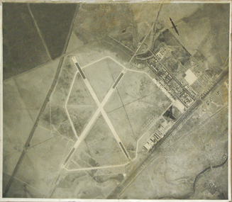
Photograph - Laverton Aerodrome circ 1940 on Cardboard and retouched Photo On A3 Paper
... Laverton Aerodrome Latitude 37 Degrees 50 Seconds South Longitude 144 Degrees 40 minutes East...Lara RSL Sub Branch McClelland Ave Lara Photo of Laverton Airfield Melbourne Victoria showing Military Aircraft Laverton Aerodrome Latitude 37 Degrees 50 Seconds South Longitude 144 Degrees 40 minutes East Original Large Photo on Cardboard plus retouched photo on photo paper Photograph Laverton Aerodrome circ 1940 on Cardboard and retouched Photo On A3 Paper ...Photo of Laverton Airfield Melbourne Victoria showing Military AircraftOriginal Large Photo on Cardboard plus retouched photo on photo paperLaverton Aerodrome Latitude 37 Degrees 50 Seconds South Longitude 144 Degrees 40 minutes East -
 Bendigo Military Museum
Booklet - NOTEBOOK RAAF, 1942-45
... Paper and cardboard notebook hand written in ink containing signal procedures, alphabet code, Q code and latitude and longitudes. Originally a larger book that was cut in half....Refer Cat No 1760.4. documents-notebooks, education military history-army RAAF Paper and cardboard notebook hand written in ink containing signal procedures, alphabet code, Q code and latitude and longitudes. Originally a larger book that was cut in half. ...Belonged to Victor Henry Evans No 418655 RAAF. Refer Cat No 1760.4.Paper and cardboard notebook hand written in ink containing signal procedures, alphabet code, Q code and latitude and longitudes. Originally a larger book that was cut in half.documents-notebooks, education, military history-army, raaf -
 Bendigo Military Museum
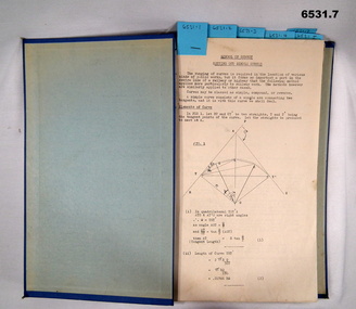
Booklet - Royal Australian Survey Corps - School of Military Survey Precis - Formula for Survey Calculations, School of Military Survey, Balcombe, Circa 1960s
... The blue hard covered foolscap sized booklet held together with two Chicago screws contains 7 x precis listed below. .1 Setting out simple Curves .2 Earthworks .3 Calculation of area by double Latitude .4 Notes on Station Adjustment by Least Squares .5 Notes on Figure Adjustment by Least Squares .6 Technical Memo No1, Computation of Tellurometer Traverses using Plain Angles and Plain Distances by WO2 R Wilson RASvy (later Major) .7 Computing Traverses in Plane Coordinates...Booklet contains 7 x precis. .1 Setting out simple Curves .2 Earthworks .3 Calculation of area by double Latitude .4 Notes on Station Adjustment by Least Squares .5 Notes on Figure Adjustment by Least Squares .6 Technical Memo No1, Computation of Tellurometer Traverses using Plain Angles and Plain Distances by WO2 R Wilson (later Major) .7 Computing Traverses in Plane Coordinates...Booklet contains 7 x precis. .1 Setting out simple Curves .2 Earthworks .3 Calculation of area by double Latitude .4 Notes on Station Adjustment by Least Squares .5 Notes on Figure Adjustment by Least Squares .6 Technical Memo No1, Computation of Tellurometer Traverses using Plain Angles and Plain Distances by WO2 R Wilson (later Major) .7 Computing Traverses in Plane Coordinates Royal Australian Survey Corps - School of Military Survey Precis - Formula for Survey Calculations Booklet Royal Australian Survey Corps - School of Military Survey Precis - Formula for Survey Calculations School of Military Survey, Balcombe ...This selection of Precis was produced by the Royal Australian Survey Corps, School of Military Survey, Balcombe, circa 1960s. The Precis are intended to instruct RASvy Surveyors employed on Engineer/ Field Survey Tasks on the calculations necessary for Surveying formula. The blue hard covered foolscap sized booklet held together with two Chicago screws contains 7 x precis listed below. .1 Setting out simple Curves .2 Earthworks .3 Calculation of area by double Latitude .4 Notes on Station Adjustment by Least Squares .5 Notes on Figure Adjustment by Least Squares .6 Technical Memo No1, Computation of Tellurometer Traverses using Plain Angles and Plain Distances by WO2 R Wilson RASvy (later Major) .7 Computing Traverses in Plane CoordinatesBlue Hard covered foolscap sized booklet held together with two Chicago screws. Booklet contains 7 x precis. .1 Setting out simple Curves .2 Earthworks .3 Calculation of area by double Latitude .4 Notes on Station Adjustment by Least Squares .5 Notes on Figure Adjustment by Least Squares .6 Technical Memo No1, Computation of Tellurometer Traverses using Plain Angles and Plain Distances by WO2 R Wilson (later Major) .7 Computing Traverses in Plane Coordinatesroyal australian survey corps, rasvy, fortuna, army survey regiment, army svy regt, asr, school of military survey -
 Bendigo Historical Society Inc.
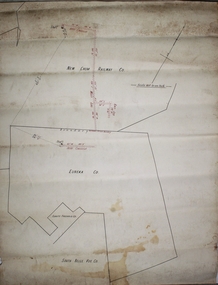
Plan - New Chum Railway Eureka
... Nearest intersection, Breen and Laurel Streets. Latitude & Longitude (WGS84): 36° 46' 20'' South , 144° 15' 57'' East Latitude & Longitude (decimal): -36.77235,144.26581 ...Nearest intersection, Breen and Laurel Streets. Latitude & Longitude (WGS84): 36° 46' 20'' South , 144° 15' 57'' East Latitude & Longitude (decimal): -36.77235,144.26581 Bendigo Margaret Roberts gold New Chum Railway mine Eureka Breen Street Railway line Golden Square Plan on white paper of New Chum Railway Gold Mine, Eureka Gold Mine and South Bellevue lease boundaries. ...New Chum Railway Mine was located in between Breen Street and the Railway Line in Golden Square. Nearest intersection, Breen and Laurel Streets. Latitude & Longitude (WGS84): 36° 46' 20'' South , 144° 15' 57'' East Latitude & Longitude (decimal): -36.77235,144.26581 Plan on white paper of New Chum Railway Gold Mine, Eureka Gold Mine and South Bellevue lease boundaries. Forms part of the Margaret Roberts Collection bendigo, margaret roberts, gold, new chum railway mine, eureka, breen street, railway line, golden square -
 Federation University Historical Collection
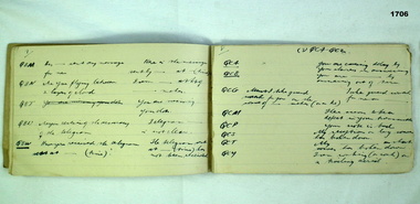
Book - Exercise Book, Astronomy Notes by William Baragwanath, 1897
... Headings include: Astronomy refraction Correction for Semi diameter Determination of True Meridian Elongation Observation Latitude Determining the TIme Convergence of Meridian Barometric Measurement of Heights Formulae Latitude Observation On the Division of Land Calculations for Observations by a Single Altitude Computations Triginometrical Rations of Two Arcs...Headings include: Astronomy refraction Correction for Semi diameter Determination of True Meridian Elongation Observation Latitude Determining the TIme Convergence of Meridian Barometric Measurement of Heights Formulae Latitude Observation On the Division of Land Calculations for Observations by a Single Altitude Computations Triginometrical Rations of Two Arcs Astronomy Notes by William Baragwanath Book Exercise Book William Baragwanath ...William Baragwanath studied at the Ballarat School of Mines, obtained a Geology certificate in 1911. He was born on 01 August 1878 at Ballarat. He joined the Victorian Department of Mines in 1897 and was Chief Mining Surveyor from 1924 to 1943. Baragwanath died at Prahran on 20 September 1966. See Book 2 - Catalogue Number 4530Marbled card covered exercise book with brown tape spine containing handwritten notes by William Baragwanath on Astronomy and astronomical, geodetic, geights and distances, North Line Latitue, Lime, etc., problems . Headings include: Astronomy refraction Correction for Semi diameter Determination of True Meridian Elongation Observation Latitude Determining the TIme Convergence of Meridian Barometric Measurement of Heights Formulae Latitude Observation On the Division of Land Calculations for Observations by a Single Altitude Computations Triginometrical Rations of Two Arcsballarat school of mines, astronomy, william baragwanath -
 Bendigo Historical Society Inc.
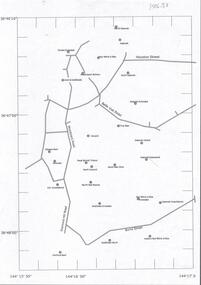
Document - CENTRAL DEBORAH GOLD MINE : GOLDEN SQUARE MINE SITES
... Roads include Diamond Hill Road, Burns Street, Woodward Road, Belle Vue Road, Houston Street. Latitude and Longitude on map....Roads include Diamond Hill Road, Burns Street, Woodward Road, Belle Vue Road, Houston Street. Latitude and Longitude on map. Document CENTRAL DEBORAH GOLD MINE : GOLDEN SQUARE MINE SITES ...Map showing mines in the Golden Square, Diamond Hill area. Roads include Diamond Hill Road, Burns Street, Woodward Road, Belle Vue Road, Houston Street. Latitude and Longitude on map.bendigo, mining, golden square mine sites -
 B-24 Liberator Memorial Restoration Australia Inc
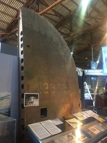
Tail Plane from 'Little Eva' crash, Circa 1941/2
... This site is registered as Doomadgee Queensland Australia, approximate GPS Co-ordinates: Latitude -17 56 24 Longitude +138 49 47....This site is registered as Doomadgee Queensland Australia, approximate GPS Co-ordinates: Latitude -17 56 24 Longitude +138 49 47. Tail Plane from 'Little Eva' crash ...Commemoration of the crash of USAAF B-24 Liberator #41-23762 'Little Eva' of the 321st Squadron, 90th Bombardment Group based at Iron Range. Crashed near Burriejell waterhole at Moonlight Creek, Escott Station in far north Queensland on 2 December 1942. Two of the ten crewmen were rescued by the manager of Escott Station after 13 days of deprivation.2bxThe tail plane/fin from the crash site of Liberator 'Little Eva'. This site is registered as Doomadgee Queensland Australia, approximate GPS Co-ordinates: Latitude -17 56 24 Longitude +138 49 47.Faded USAAF Insignia 41-23762little eva, 4123762, usaaf -
 Flagstaff Hill Maritime Museum and Village
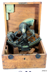
Instrument - Sextant, Troughton & Simms, late 19th C. to 1922
... A sextant is an astronomical instrument used in measuring angular distances especially the altitudes of sun, moon and starts at sea determining latitude and longitude....A sextant is an astronomical instrument used in measuring angular distances especially the altitudes of sun, moon and starts at sea determining latitude and longitude. This sextant is an example of a 19th-century marine instrument used for finding location at sea. ...This sextant is very similar to a 1915 Sextant design. A sextant is an astronomical instrument used in measuring angular distances especially the altitudes of sun, moon and starts at sea determining latitude and longitude.This sextant is an example of a 19th-century marine instrument used for finding location at sea. It was made by London scientific instrument maker Troughton and Simms, which originated in 1826 and continued until 1922.Sextant and its fitted square wooden box. The handle of the sextant is carved with a cross-hatched pattern. Made by Troughton and Simms, London.flagstaff hill, warrnambool, shipwrecked-coast, flagstaff-hill, flagstaff-hill-maritime-museum, maritime-museum, shipwreck-coast, flagstaff-hill-maritime-village, sextant, navigational instrument, marine navigation, marine equipment, instrument, navigation, troughton and simms, london, scientific instrument -
 Bendigo Historical Society Inc.
Plan - New Chum Goldfields Co. N.L, 20.7.1912
... New Chum Goldfield Co. was located at the Diamond Hill Road end of Spring Gully Reservoir. Latitude: -36.8114952741, Longitude: 144.2747542333 The location is now within the fenced area of the Spring Gully Reservoir, and not accessible. ...History House 11 Mackenzie Street Bendigo goldfields New Chum Goldfield Co. was located at the Diamond Hill Road end of Spring Gully Reservoir. Latitude: -36.8114952741, Longitude: 144.2747542333 The location is now within the fenced area of the Spring Gully Reservoir, and not accessible. gold mining gold Bendigo New Chum Goldfields Co. ...New Chum Goldfield Co. was located at the Diamond Hill Road end of Spring Gully Reservoir. Latitude: -36.8114952741, Longitude: 144.2747542333 The location is now within the fenced area of the Spring Gully Reservoir, and not accessible. New Chum Goldfields Mine longitudinal plan. Written on plan 'W.H. Cundy, 20.7.12' Plan forms part of the Margaret Roberts Collection.gold mining, gold, bendigo, new chum goldfields co. n.l., spring gully reservoir -
 Unions Ballarat
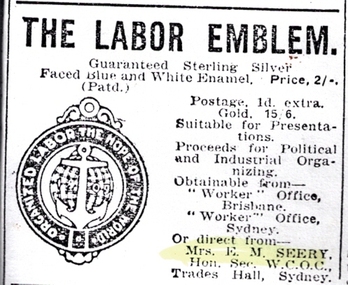
Memorabilia - Pin, 1907
... Silver anchor superimposed over a white globe (with silver latitude and longitude lines). A safety pin is welded to the back. ...Significant to industrial action, union organising and the labour movement in Australia. btlc ballarat trades and labour council unions ballarat ballarat trades hall political labour league artefacts - jewellery gardner, annie emily industrial action campaigns relief - fundraising Silver anchor superimposed over a white globe (with silver latitude and longitude lines). A safety pin is welded to the back. ...This pin was created by Miss Annie Emily Gardner to raise relief money to support industrial unrest in Newcastle. It was reported in the Newcastle Morning Herald that Miss Gardner was vice-president of the Women's Organising Committee of the Political Labour League. A copy of an advertisement for the pin has been uploaded here. Price of the silver pin was 2/- and gold 15/6. Photograph of the pin - to come. Donated to Ballarat Trades Hall by John Mildren. Significant to industrial action, union organising and the labour movement in Australia.Pin. Round. Sterling silver.Silver anchor superimposed over a white globe (with silver latitude and longitude lines). A safety pin is welded to the back. Blue outer circle with inscription: "Organized labor the hope of the world 1909". Inscription on the back: "USA ???" in very tiny font.btlc, ballarat trades and labour council, unions ballarat, ballarat trades hall, political labour league, artefacts - jewellery, gardner, annie emily, industrial action, campaigns, relief - fundraising -
 Flagstaff Hill Maritime Museum and Village
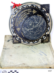
Planisphere, Early 20th Century
... The star chart contains the brightest stars, constellations and (possibly) deep-sky objects visible from a particular latitude on Earth. The night sky that one sees from the Earth depends on whether the observer is in the northern or southern hemispheres and the latitude. ...Planispheres only show the stars visible from the observer's latitude; stars below the horizon are not included. ...The word Planisphere (Latin planisphaerium) was originally used in the second century by Claudius Ptolemy to describe the representation of a spherical Earth by a map drawn in the plane. This usage continued into the Renaissance: for example Gerardus Mercator described his 1569 world map as a Planisphere. The word describes the representation of the star-filled celestial sphere on the plane. The first star chart to have the name "Planisphere" was made in 1624 by Jacob Bartsch. Bartsch was the son-in-law of Johannes Kepler, discoverer of Kepler's laws of planetary motion. A significant item of celestial mapping used by marine navigators This particular item was made and used in the first quarter to half of the 20th centuryPlanisphere of northern hemisphere, with canvas bag. Planisphere consists of a circular star chart attached at its centre to an opaque circular overlay that has a clear elliptical window or hole so that only a portion of the sky map will be visible in the window or hole area at any given time. The chart and overlay are mounted so that they are free to rotate about a common pivot point at their centres. The star chart contains the brightest stars, constellations and (possibly) deep-sky objects visible from a particular latitude on Earth. The night sky that one sees from the Earth depends on whether the observer is in the northern or southern hemispheres and the latitude. A Planisphere window is designed for a particular latitude and will be accurate enough for a certain band either side of that. Planisphere makers will usually offer them in a number of versions for different latitudes. Planispheres only show the stars visible from the observer's latitude; stars below the horizon are not included. A complete twenty-four-hour time cycle is marked on the rim of the overlay. A full twelve months of calendar dates are marked on the rim of the starchart. The window is marked to show the direction of the eastern and western horizons. The disc and overlay are adjusted so that the observer's local time of day on the overlay corresponds to that day's date on the star chart disc. The portion of the star chart visible in the window then represents (with a distortion because it is a flat surface representing a spherical volume) the distribution of stars in the sky at that moment for the Planispheres designed location. Users hold the Planisphere above their head with the eastern and western horizons correctly aligned to match the chart to actual star positions. "Made in Germany for GEORGE PHILIP & SONS Ltd. Geographical and Educational Depot, 32 Fleet Street, London" Canvas bag has "Capt. H (Howard) Tyler from Captain H. F. Woolf" "Tyler 22 ? St East Brighton" also "13 Halls St Flinders"flagstaff hill, warrnambool, shipwrecked-coast, flagstaff-hill, flagstaff-hill-maritime-museum, maritime-museum, shipwreck-coast, flagstaff-hill-maritime-village, planisphere, star map, marine navigation, maps, george philip & sons -
 Flagstaff Hill Maritime Museum and Village
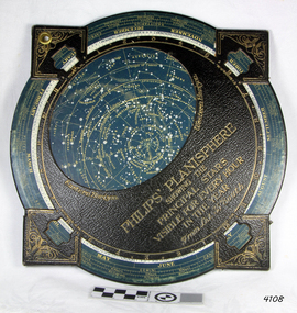
Planisphere, Early 20th Century
... The star chart contains the brightest stars, constellations and (possibly) deep-sky objects visible from a particular latitude on Earth. The night sky that one sees from the Earth depends on whether the observer is in the northern or southern hemispheres and the latitude. ...Planispheres only show the stars visible from the observer's latitude; stars below the horizon are not included. ...The word Planisphere (Latin planisphaerium) was originally used in the second century by Claudius Ptolemy to describe the representation of a spherical Earth by a map drawn in the plane. This usage continued into the Renaissance: for example Gerardus Mercator described his 1569 world map as a Planisphere. The word describes the representation of the star-filled celestial sphere on the plane. The first star chart to have the name "Planisphere" was made in 1624 by Jacob Bartsch. Bartsch was the son-in-law of Johannes Kepler, discoverer of Kepler's laws of planetary motionA significant item of celestial mapping used by marine navigators This particular item was made and used in the first quarter to half of the 20th century.Planisphere consists of a circular star chart attached at its centre to an opaque circular overlay that has a clear elliptical window or hole so that only a portion of the sky map will be visible in the window or hole area at any given time. The chart and overlay are mounted so that they are free to rotate about a common pivot point at their centers. The star chart contains the brightest stars, constellations and (possibly) deep-sky objects visible from a particular latitude on Earth. The night sky that one sees from the Earth depends on whether the observer is in the northern or southern hemispheres and the latitude. A Planisphere window is designed for a particular latitude and will be accurate enough for a certain band either side of that. Planisphere makers will usually offer them in a number of versions for different latitudes. Planispheres only show the stars visible from the observer's latitude; stars below the horizon are not included. A complete twenty-four-hour time cycle is marked on the rim of the overlay. A full twelve months of calendar dates are marked on the rim of the star chart. The window is marked to show the direction of the eastern and western horizons. The disc and overlay are adjusted so that the observer's local time of day on the overlay corresponds to that day's date on the star chart disc. The portion of the star chart visible in the window then represents (with a distortion because it is a flat surface representing a spherical volume) the distribution of stars in the sky at that moment for the Planispheres designed location. Users hold the Planisphere above their head with the eastern and western horizons correctly aligned to match the chart to actual star positions. "Sold by J DONNE & SON, Booksellers & Stationers, 349 Post Office Place Melbourne 349. Admiralty Chart Agents" and " Made in Germany for George Philip & Son Ltd" England . Signature "Capt E. B. ?..id, 22 Baund St"flagstaff hill, warrnambool, shipwrecked-coast, flagstaff-hill, flagstaff-hill-maritime-museum, maritime-museum, shipwreck-coast, flagstaff-hill-maritime-village, star map, marine navigation, maps, george philip & sons -
 Flagstaff Hill Maritime Museum and Village
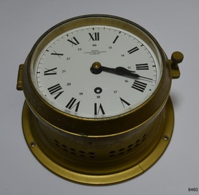
Instrument - Chronometer or Marine Clock
... ...latitude...The Master or Navigator of a ship could use the chronometer and the positions of celestial bodies to calculate the ship’s latitude at sea. In 1905 the business Chronometerwerke GmbH was formed in Frankfurt, Germany, to supply the country with high-quality mechanical chronometers and ship clocks for their maritime trade, making the country independent of other international suppliers such as those in England. ...The Master or Navigator of a ship could use the chronometer and the positions of celestial bodies to calculate the ship’s latitude at sea. In 1905 the business Chronometerwerke GmbH was formed in Frankfurt, Germany, to supply the country with high-quality mechanical chronometers and ship clocks for their maritime trade, making the country independent of other international suppliers such as those in England. ...This chronometer was made around 1936 and has been on display at Flagstaff Hill for over 40 years as part of the exhibit of the ‘Reginald M’, an Australian-built, 19ss, coastal trader vessel. A chronometer is an accurate mechanical instrument used for measuring time. It is constructed carefully to remain stable even under the changing conditions of seafaring life such as temperature, humidity and air pressure. The Master or Navigator of a ship could use the chronometer and the positions of celestial bodies to calculate the ship’s latitude at sea. In 1905 the business Chronometerwerke GmbH was formed in Frankfurt, Germany, to supply the country with high-quality mechanical chronometers and ship clocks for their maritime trade, making the country independent of other international suppliers such as those in England. In 1938 the firm was renamed Wempe Chronometerwerke. The business continues today. Its products now include its well-known chronometers, battery-powered ship clocks, ship’s bell clocks, barometers, barographs, thermometers, hygrometers, comfort meters to measure temperature and humidity, and wristwatches. The company also performs chronometer testing facilities for the State’s Weights and Measures office. The article written by Givi in July 2022 “The Basics of Marine Meteorology – a Guide for Seafarers” refers to the weather’s signs and patterns being repeated over and over, and the recording of these observations helps forecasters predict changes in the weather. The chronometer is an example of a mechanical navigational marine instrument in use in the early to the mid-20th century. The maker is significant as part of a German government initiative to be self-sufficient in the production of good quality marine technology. This chronometer is significant as part of the exhibit, the Australian-built vessel, 1922 coastal trader ‘Reginald M’, listed on the Australian Register of Historic Vessels and on display for over 40 years.Marine chronometer or marine clock, brass case, glass cover, Roman numerals, 24-hour numbers beside them. Two black hands, a keyhole for winding and ventilation holes in the side. The base has a collar with four machined mounting holes. Inscriptions are on the clock’s face."Made in Germany" and "WEMPE / CHRONOMETERWERKE / HAMBURG"flagstaff hill, flagstaff hill maritime museum and village, warrnambool, maritime museum, maritime village, great ocean road, shipwreck coast, marine meteorology, horology, chronometer, marine technology, latitude, marine navigation, mechanical instrument, scientific instrument, ship clock, chromometerwerke gmbh, wempe chronometerwerke, marine clock -
 Bendigo Historical Society Inc.
Book - Geographical dictionary
... Entries include latitude and longitude, populations, proximity to other towns, local industries, coach and mail runs, hotels, churches and schools....Entries include latitude and longitude, populations, proximity to other towns, local industries, coach and mail runs, hotels, churches and schools. ...The Gazetteer presents an extensive a to z list of Victorian towns and villages, lakes, rivers and creeks, islands, bays, hills and mountains, runs and other localities and features. Entries include latitude and longitude, populations, proximity to other towns, local industries, coach and mail runs, hotels, churches and schools.Bailliere's Victorian Gazetteer and road guide containing the most recent and accurate information as to every place in the colony. Brown hardcover book, on the spine: Victorian Gazetteer with map 1865. The first and last pages are advertisements. The book has 442 pages listing every place in the colony. The map is not included. Compiled by Robert P. Whitworth. Published by Bailliere, Regent Street Unreadable name on first page and the name of F. Houston in blue pen on first page geographic dictionary, colony of victoria -
 Bendigo Military Museum
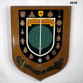
Plaque - AUSTRALIAN FORCE VIETNAM PLAQUE
... Plaque features a shield shaped plate with sword, globe with lines of latitude and longitude and banner with yellow and red stripes. ...Plaque features a shield shaped plate with sword, globe with lines of latitude and longitude and banner with yellow and red stripes. ...Plaque features the seventeen insignia of units which served in the Vietnam War. Part of the Cooper Collection. See Catalogue No. 9586.2 for details of service for "Keith Cooper", No.3798359.Shield shaped light brown coloured wooden plaque. Plaque features a shield shaped plate with sword, globe with lines of latitude and longitude and banner with yellow and red stripes. Around the outside of this feature are seventeen unit insignia on a black background. Bottom of the plaque features a Rising Sun Badge above a gold coloured banner with 'AUSTRALIAN FORCE VIETNAM' in black lettering.cooper collection, keith cooper, plaque, unit insignia, vietnam war, australian force vietnam -
 Creswick Campus Historical Collection - University of Melbourne
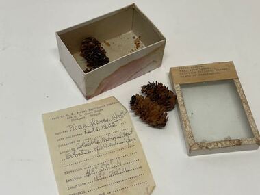
Plant specimen - Plant Specimen from the VSF Herbarium, Picea glauca. Var. albertiana. Colville National Forest. State of Washington
... Date colledted: Fall 1935. Latitude: 40/50 N. Longitude: 119/20 W....Date colledted: Fall 1935. Latitude: 40/50 N. Longitude: 119/20 W. Plant Specimen from the VSF Herbarium - seeds in a cardboard box with a glass lid Picea glauca. ...Plant Specimen from the VSF Herbarium - seeds in a cardboard box with a glass lidBox: Picea glauca. Var. albertiana. Colville National Forest. State of Washington.. Note inside: Pacific N.W. Forest Experiment Station 424 U.S. Court House, Portland Oregon. Species: Picea glauca albertiana. Date colledted: Fall 1935. Latitude: 40/50 N. Longitude: 119/20 W. -
 Wodonga & District Historical Society Inc
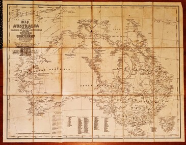
Map - Australia Shewing the Tracks of the Late Explorers
... Part coloured with tracks of 15 explorers including Eyre, Stuart, Leichhardt and Burke and Wills with notes and some details of latitude and longitude. Relief relating to the major mountain ranges is indicated. ...Part coloured with tracks of 15 explorers including Eyre, Stuart, Leichhardt and Burke and Wills with notes and some details of latitude and longitude. Relief relating to the major mountain ranges is indicated. ...Charles George Eastland Platts arrived in South Australia on 22 March 1839, and soon after established his business in Adelaide. He became Adelaide’s first bookseller. It was known as Platts’ Library but was also a bookshop and stationer. His business was also used as a postal receiving house. Platts died on 14 November 1871. Boyle Travers Finniss (18 August 1807 – 24 December 1893) had an early career in the British Military before selling off his commission in 1835. He was appointed assistant surveyor to Colonel William Light in South Australia. He then had several roles in public service. Finniss was the first premier and Chief Secretary South Australia, serving from 24 October 1856 to 20 August 1857. In 1864 he was appointed as the Government Resident of the Northern Territory. He was filling this role at the time when the map was produced and is acknowledged on the map.This is a very early map documenting the exploration and opening up of Australia.Map of Australia and part of Indonesia. Part coloured with tracks of 15 explorers including Eyre, Stuart, Leichhardt and Burke and Wills with notes and some details of latitude and longitude. Relief relating to the major mountain ranges is indicated. At the bottom of the map is a key to the explorers and a list of the counties in the different states. Top left side of map has small sketch of the Platts (publisher) building at the corner of King William Street.Map of Australia shewing the tracks of late explorers into the interior and across the continent together with their discoveries map/ projected, compiled and drawn by O.W.O. Bennett Most Respectfully Dedicated to LIEUT. COL. BOYLE TRAVERS FINISS Government Resident of the Northern Territory of SOUTH AUSTRALIAexplorers -- australia -- maps, rare maps australia -
 Flagstaff Hill Maritime Museum and Village
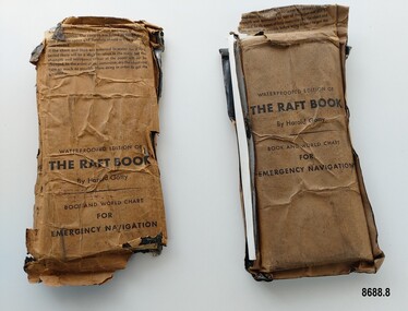
Booklet - Book and World Chart for Emergency Navigation, George Grady Press, The Raft Book, 1943
... Each packet contains a folded 64 page paper booklet with detailed instructions for navigating a small craft in open seas, a folded chart (with a map of the world and oceans, well known constellations, latitude and longitude charts, Greenwich time and a scale for string lengths and Harp scale) and a long folded paper calendar strip....Each packet contains a folded 64 page paper booklet with detailed instructions for navigating a small craft in open seas, a folded chart (with a map of the world and oceans, well known constellations, latitude and longitude charts, Greenwich time and a scale for string lengths and Harp scale) and a long folded paper calendar strip. ...Harold Gatty was born on January 5th, 1903 in Campbell Town, Tasmania. He was a navigator and aviation pioneer. He began his career learning navigation at the age of 14 as a midshipman at the Royal Australian Naval College but withdrew after three years and became an apprenticed ship's officer with the Patrick Steamship Company of Sydney. After W. W. 1 he joined the Australian Merchant Navy where he learned the constellations while standing night watch and became an expert in celestial navigation while serving on many ships sailing between Australia and California. In 1927 he moved to California and opened a navigation school and also a laboratory repairing navigational equipment. At this time he became very interested in air navigation and was aware of the limitations of existing methods and instruments for aerial navigation. He began researching ways of improving aerial navigation. Two early inventions of his were his air sextant and a ground speed and drift indicator which formed the basis of the automatic pilot which later came to be standard equipment on most aircraft. He worked with several record breaking pilots including Ann Morrow Lindbergh (who went on to serve as a navigator for her husband Charles Lindbergh), helped Wiley Post break the world record circumnavigating the Earth, invented a new method of "dead reckoning" that revolutionised the ability to fly safely through cloudy conditions without drifting off course and famously navigated a small plane (whilst trying to cross the Pacific) over 1900 km through fog (with no radio) and using only his dead reckoning techniques, back to their starting point in Japan after they developed fuel problems. In 1932 Gatty received the Distinguished Flying Cross from President Hoover. In 1934 Gatty formed the South Seas Commercial Company with Donald Douglas with the aim to deliver air services to the islands of the South Pacific. The Company was sold to Pan Am but he continued to work for them. In 1935 he went on a sailing expedition investigating several small islands in the South Pacific and was briefly marooned on Baker Island. He was able to use his extensive knowledge of seabird habits to save the crew. He was also very interested in the ability of the Polynesians to navigate using the stars. During the Second World War Gatty was given the honorary rank of Group Captain in the Royal Australian Air Force (RAAF) and worked for the U. S. Army Air Forces (USAAF) in the South Pacific. In 1943 he moved to Washington where he developed a survival book (The Raft Book) specifically for boat crews or air crews flying over the Pacific to help them survive and navigate their life rafts in remote areas of the ocean. The original book was 152 pages long however a condensed version was made which consisted of a 64 page booklet, combined map and star chart and calendar strip enclosed in a waterproof slipcase, to be placed in life rafts for emergency use. The booklet included navigational advice and ideas such as ocean currents, estimation of distance, using a compass, measurement of angles, recognising and steering by the stars, land indications from sea birds, migration of sea birds and insects, sounds from the land, the scent of the land and ocean currents and the colour of the sea etc. After W.W.2 Gatty moved to Fiji and formed Fiji Airways (which later became Air Pacific). Harold Gatty died in August 1957.The two copies of "The Raft Book" are significant as they are a written summary of the many methods of sea navigation (both modern and historical) that existed in the 1940's. They are also a record of Harold Gatty, who played a significant role in the development of modern day aerial navigation using his understanding of different sea navigational techniques.Two rectangular brown packets with waterproof coverings (oiled paper) titled "The Raft Book" by Harold Gatty. Each packet contains a folded 64 page paper booklet with detailed instructions for navigating a small craft in open seas, a folded chart (with a map of the world and oceans, well known constellations, latitude and longitude charts, Greenwich time and a scale for string lengths and Harp scale) and a long folded paper calendar strip.Front of package - "WATERPROOFED EDITION OF/ THE RAFT BOOK / By Harold Gatty / BOOK AND WORLD CHART / FOR / EMERGENCY NAVIGATION / To open envelope tear along above line. If the envelope is used again fold the flap to keep contents dry. 1. This envelope contains a book, chart and tape for emergency navigation. The contents are folded to take up the least possible space and therefore should not be removed until needed. 2. if the chart and tape are immersed in water for a long period, there will be a slight variation in the scale but the strength and resistence to tear of the paper will not be changed. In the event of long immersion, dry the chart and tape as much as possible before using in order to in order to get the greatest accuracy in scale. Front of booklet - THE RAFT BOOK / LORE OF THE SEA AND SKY /By Harold Gatty IMPORTANT FOR YOUR SECURITY/Upon abandoning ship you may have to be your own navigator. Take the following pre/cautions for your own safety:/ Carry a good type of pocket watch / keep it wound and have it running on Greenwich (England) / Time, which you can get from the navigating officer. / Keep track of the date at Greenwich; and on a 24-hour basis, / know whether the time is, say, 6 hours (6 A.M.) showing on / your watch, or 18 hours (6P.M.) Greenwich. / PROECT YOUR WATCH. GET A RUBBER SACK FOR IT (OBTAIN FROM PHARMACIST) AND KEEP IT DRY / KEEP A PENCIL IN YOUR POCKET/ POSITION OF SHIP WHEN ABANDONED PRINTED IN UNITED STATES OF AMERICA GEORGE GRADY PRESS, NEW YORK/COPYRIGHT, 1943, BY HAROLD AND FENNA GATTYflagstaff hill maritime museum and village, shipwreck coast, warrnambool, the raft book, harold gatty, book and world chart for emergency navigation, ww 2, ww ii, navigation, air navigation, aerial navigation, lindbergh, wiley post, dead reckoning, south seas commercial company, u.s. army airforce, usaaf, survival book, life rafts, sea navigation, emergency navigation, fiji airways, harp scale -
 Bendigo Military Museum
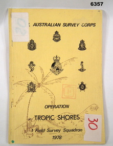
Administrative record - Royal Australian Survey Corps - Operation Tropic Shores, 1 Field Survey Squadron 1978, 31 Aug 1978
... The Operation was the field completion of Cape York 1;50,000 Mapping North of latitude 15 degrees S. Plotting was undertaken by 2, 4 and 5 Fd Svy Sqns with 1Fd Svy Sqn undertaking the mounting and Management of the field completion phase. ...The Operation was the field completion of Cape York 1;50,000 Mapping North of latitude 15 degrees S. Plotting was undertaken by 2, 4 and 5 Fd Svy Sqns with 1Fd Svy Sqn undertaking the mounting and Management of the field completion phase. ...Operation Tropic Shores was conducted in 2 phases, Sep 1977 and May / Jun 78. The Operation was the field completion of Cape York 1;50,000 Mapping North of latitude 15 degrees S. Plotting was undertaken by 2, 4 and 5 Fd Svy Sqns with 1Fd Svy Sqn undertaking the mounting and Management of the field completion phase. Re-visiting and targeting of existing trig stations was also carried out as an opportunity task.Booklet, A4 cream cardboard cover, stapled Left Hand side, containing a report and plotted maps. Cover has Title and the Badges of the Australian Army Corps who participated in the Operation. 2 fd svy sqn, 4 fd svy sqn, 5 fd svy sqn, royal australian survey corps, 1 field survey squadron, 1fd svy sqn, rasvy, fortuna, army survey regiment, army svy regt, asr -
 Eltham District Historical Society Inc
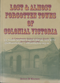
Book, Angus B. Watson, Lost & almost forgotten towns of colonial Victoria : a comprehensive analysis of census results for Victoria, 1841-1901, 2003
... It includes in excess of 1400 entries with the latitude and longitude for each town, numbers males and females in the town, and the number of occupied dwellings (where available). ...It includes in excess of 1400 entries with the latitude and longitude for each town, numbers males and females in the town, and the number of occupied dwellings (where available). ...Lists all towns and villages with entries in the Victorian censuses between 1841 and 1901. It includes in excess of 1400 entries with the latitude and longitude for each town, numbers males and females in the town, and the number of occupied dwellings (where available). For many of these settlements the only visible trace of them today is in the census results collected by the fledgling governments of Colonial Victoria. It is a comprehensive reference and a fascinating insight into the movements of early populations of new Australians.cities and towns victoria, history 19th century, statistics, ghost towns - victoria, geographical names victoria, victoria census -
 Bendigo Historical Society Inc.
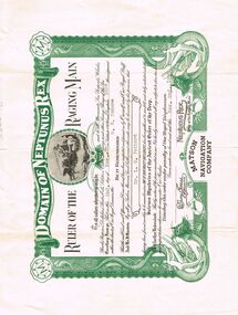
Document - LYDIA CHANCELLOR COLLECTION; CROSSING THE EQUATOR CERTIFICATE
... It is a Crossing of the Equator Certificate which occurred on the 2nd Nov. 1930 in Latitude 000 '00' and Longitude 165 W on S.S. ...It is a Crossing of the Equator Certificate which occurred on the 2nd Nov. 1930 in Latitude 000 '00' and Longitude 165 W on S.S. ...A certificate with green and black ink with the heading 'Domain of Neptunus Rex.' It is a Crossing of the Equator Certificate which occurred on the 2nd Nov. 1930 in Latitude 000 '00' and Longitude 165 W on S.S. Sonoma. Initiation of Mr. L.G. Pethard, ' having been found worthy to be remembered as one of our trusty shellbacks has been gathered to our fold and duly initiated into the 'Solemn Mysteries of the Ancient Order of the Deep.' 'Davy Jones His Majesty's Scribe.' 'Neptunus Rex Order of the Raging Main.' Matson Navigation Company.document, certificate, crossing the equator, lydia chancellor, collection, mr. l.g. pethard, person, equator -
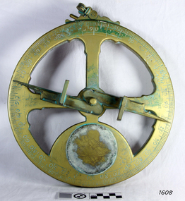 Flagstaff Hill Maritime Museum and Village
Instrument - Mariner's astrolabe
... The measurement of altitude could then be used to calculate the ship’s latitude but at that time in history there was no means of measuring longitude. ...The measurement of altitude could then be used to calculate the ship’s latitude but at that time in history there was no means of measuring longitude. ...This representative example demonstrates a mariner’s astrolabe. Historical examples are rare. There are less than one hundred known to exist and most of these have been recovered from shipwrecks, many from Spanish and Portuguese vessels. An astrolabe is a measuring device once used to navigate the seas by observing the sun and stars to measure their altitude. The measurement of altitude could then be used to calculate the ship’s latitude but at that time in history there was no means of measuring longitude. The body of the navigational astrolabe was cast brass and much heavier, and less complicated than the variety used on land. The heavier weight and cut-away shape reduced the effect of the wind and waves when trying to use it at sea. A mariner’s astrolabe or ‘star finder’ is a simplified version than that used by Arabic astronomers to find the altitude of the sun and stars above the horizon, and time of the sunrise and sunset. It is a forerunner to the quadrant, octant and sextant and was popular for about 200 years over the 1500s and 1600s to find the latitude of a ship at sea. The user held the astrolabe at eye level and, usually with assistance, aligned the stars through the two small sights (pinnules), then read the altitude indicated by the pointer on the arm. It could also be used to sight the sun by holding it lower down, aiming it at the sun, and adjusting it until the sun shone through both pinnules. This astrolabe is an example used to demonstrate the mariner’s astrolabe, which was navigational tool of the 1500s and 1600s, in the time before longitude was able to be determined. It is a forerunner to modern navigation technology. Mariner’s astrolabe – a representative example. A gold painted, disc shaped object with cut outs and revolving arm in centre. The arm has two sights attached at right angles. The top has a ring attached. Measurements are marked in degrees in a circular scale around outer edge.flagstaff hill, warrnambool, maritime village, maritime museum, flagstaff hill maritime museum & village, shipwreck coast, great ocean road, navigation instrument, navigation tool, navigation, astrolabe, mariner’s astrolabe, measure latitude, measure altitude, arabic navigation, measuring device, star finder, astronomy, marine tool, marine instrument