Showing 84 items matching "local government commission"
-
 Eltham District Historical Society Inc
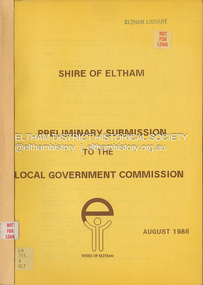
Document, Shire of Eltham, Shire of Eltham Preliminary submission to the Local Government Commission, August 1986
... Shire of Eltham Preliminary submission to the Local Government Commission...local government in Victorian when, in 1994 the Kennett State government restructed local government. The reforms dissolved 201 Councils and created 78 new councils through amalgamations. In suburban Melbourne 53 municipalities were reduced to 26. Council amalgamation annexation Rates Report produced by the Shire of Eltham in August 1986 as a prelimary response to proposed municipal restructure in the state of Victoria Shire of Eltham Preliminary submission to the Local Government Commission Document Shire of Eltham ...Report produced by the Shire of Eltham in August 1986 as a prelimary response to proposed municipal restructure in the state of Victorianon-fictionReport produced by the Shire of Eltham in August 1986 as a prelimary response to proposed municipal restructure in the state of Victoriacouncil amalgamation, annexation, rates -
 Clunes Museum
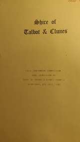
Document (Item) - FOLDER, Shire of Talbot & Clunes, Local Government Commission oral submission by shire of Talbot and Clunes Council Wednesday 9th July 1986, 9/7/1986
... Local Government Commission oral submission by shire of Talbot and Clunes Council Wednesday 9th July 1986...council amalgamations Shire of Talbot & Clunes Manilla Folder, Containing a photocopy of oral submission by the shire of Talbot and Clunes, Stapled. Local Government Commission oral submission by shire of Talbot and Clunes Council Wednesday 9th July 1986 Document FOLDER Shire of Talbot & Clunes ...council amalgamations, shire of talbot & clunes -
 Whitehorse Historical Society Inc.
Article, Nunawading looks at Box Hill merger, 1986
... Local Government...City of Nunawading...Local Government Commission...Nunawading Council has sent a report to the Local Government Commission seeking a close examination of a possible reunion with the City of Box Hill. ...Local Government City of Nunawading Local Government Commission Amalgamations unawading Council has sent a report to the Local Government Commission seeking a close examination of a possible reunion with the City of Box Hill. ...unawading Council has sent a report to the Local Government Commission seeking a close examination of a possible reunion with the City of Box Hill.Nunawading Council has sent a report to the Local Government Commission seeking a close examination of a possible reunion with the City of Box Hill. Box Hill is not convinced of advantages of the reunion but has agreed to hold discussions with both Nunawading and the State Government.unawading Council has sent a report to the Local Government Commission seeking a close examination of a possible reunion with the City of Box Hill.local government, city of nunawading, local government commission, amalgamations -
Port Melbourne Historical & Preservation Society
Archive - Archive, Documents collected by Perce WHITE during his terms as Mayor and Councillor of the City of Port Melbourne from 1972 to 1994, 1972 - 1994
... Local Government - City of Port Melbourne...Town Planning - Proposals Shelved - Bayside...Amalgamation...Local Government - City of South Melbourne...Local Government - City of St Kilda...Local Government - City of Port Phillip...Sandridge City Development Co Pty Ltd...SCDC...Local Government Commission...Port Melbourne Historical & Preservation Society Port Melbourne Town Hall 333 Bay Street Port Melbourne melbourne Documents collected by Perce White during his terms as Mayor, and service as a Councillor of the City of Port Melbourne from 1972 to 1994 Local Government - City of Port Melbourne Town Planning - Proposals Shelved - Bayside Amalgamation Local Government - City of South Melbourne Local Government - City of St Kilda Local Government - City of Port Phillip Sandridge City Development Co Pty Ltd SCDC Local Government Commission Perce McGuire WHITE Perce WHITE Various documents sorted into 23 manilla folders held in two archive boxes (.01 & .02) as per attached list. ...Documents collected by Perce White during his terms as Mayor, and service as a Councillor of the City of Port Melbourne from 1972 to 1994Various documents sorted into 23 manilla folders held in two archive boxes (.01 & .02) as per attached list. From the folders numbered 1-8 originally sorted by Janet BOLITHO in 2008, papers were extracted by Glen COSHAM in March 2014 and further re-sorted into folder numbers 9 to 23. In April 2016, Jill DAWSON extracted folder nos. 12-15 and consolidated these with other documents relating to the proposed Sandridge City Bayside Corporation development.local government - city of port melbourne, town planning - proposals shelved - bayside, amalgamation, local government - city of south melbourne, local government - city of st kilda, local government - city of port phillip, sandridge city development co pty ltd, scdc, local government commission, perce mcguire white, perce white -
Southern Sherbrooke Historical Society Inc.
Information folder - Local Government Amalgamations 1986, 1985 & 1986
... Local Government amalgamations in Victoria in 1986. Contents: -copy of "Local Government Act 1958, appointment of a division of the local government commission and referral of proposals to the division", 8 pages and 6 explanatory maps -memo, dated 21 November 1985 from K. ...Matson, General Manager, Shire of Sherbrooke, to all councillors, re. local government commission and municipal restructure, 12 pages including map -letter, Warwick Heine, CEO, Shire of Lilydale to K. ...Folder containing information pertaining to the Local Government amalgamations in Victoria in 1986. Contents: -copy of "Local Government Act 1958, appointment of a division of the local government commission and referral of proposals to the division", 8 pages and 6 explanatory maps -memo, dated 21 November 1985 from K. E. Matson, General Manager, Shire of Sherbrooke, to all councillors, re. local government commission and municipal restructure, 12 pages including map -letter, Warwick Heine, CEO, Shire of Lilydale to K. E. Matson, General Manager, Shire of Sherbrooke, dated 16 April 1986, re. local government restructure (2 copies) -booklet, "The Restructure of Local Government in Victoria: Options Paper Eastern Melbourne Segment", Local Government Commission June 1986, 24 pages -article "Residents to fight land deal", Knox-Sherbrooke News, 17 June1986, re. proposed annexation of part of Lysterfield by Berwick Council -article "Knox and Sherbooke align for the future", The Trader, 30 April 1986, re. alignment of common boundary -article "Boundary changes 'just a joke'", by Cheryl Critchley, Knox-Sherbrooke News, 6 May 1986 , re. Knox-Sherbrooke boundary alignment -article "Border clash worsens", by Peter Janky, Mountain District Free Press, 7 May 1986, re. Sherbrooke-Lilydale boundary changes -article "Ranges future is still clouded", The Free Press 30 April 1986, re. proposal to form a shire covering Dandenong Ranges -article "Sherbrooke wins first battle in restructuring", by Peter Janky, Free Press, 30 April 1986, re. ceding of forest areas by Knox to Sherbrooke.shire of sherbrooke, shire of lilydale, knox city council, berwick shire council -
 Eltham District Historical Society Inc
Audio - Audio Recording, Audio Recording; 2018-10-11 The Spirit of Eltham with Lynnsay Prunotto and Hamish Knox, 11 Oct 2018
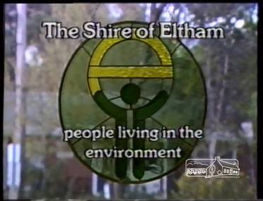
... We will view a video produced for the Shire of Eltham in response to the 1985 Victorian Local Government Commission Report titled ‘The Restructure of Local Government in Victoria – Principles and Program’ (the Morris review). ...We will view a video produced for the Shire of Eltham in response to the 1985 Victorian Local Government Commission Report titled ‘The Restructure of Local Government in Victoria – Principles and Program’ (the Morris review). ...October Meeting (Newsletter No. 242, Oct. 2018) At our Society meeting at 8.00pm on Wednesday 10th October 2018 we will explore ideas about what is considered to be the ‘Spirit of Eltham’. We will view a video produced for the Shire of Eltham in response to the 1985 Victorian Local Government Commission Report titled ‘The Restructure of Local Government in Victoria – Principles and Program’ (the Morris review). The recommendation was to amalgamate the Shires of Eltham and Diamond Valley, something that Eltham Council did not support as being appropriate for the shire or compatible with the ‘Spirit of Eltham’. We will also be fortunate to have a presentation on this theme by Lynnsay Prunotto, a local architect, who is also involved in community planning activities, as well as some insights from Hamish Knox on his experience of growing up and working for many years in the region.1:29:41 duration Digital MP3 File 32 MB audio recording, eltham district historical society, hamish knox, lynnsay prunotto, meeting, society meeting, spirit of eltham -
 Eltham District Historical Society Inc
Film - Video (VHS), IMP Productions, Eltham Shire Council - People Living in the Environment (Series 69, Item 2), 7 Oct 1985
... Shire of Eltham Archives: Series 69, Item 2 This video was produced for the Shire of Eltham in response to the 1985 Victorian Local Government Commission Report titled ‘The Restructure of Local Government in Victoria – Principles and Program’ (the Morris review). ...Eltham District Historical Society Inc 728 Main Rd Eltham melbourne Shire of Eltham Archives: Series 69, Item 2 This video was produced for the Shire of Eltham in response to the 1985 Victorian Local Government Commission Report titled ‘The Restructure of Local Government in Victoria – Principles and Program’ (the Morris review). ...Shire of Eltham Archives: Series 69, Item 2 This video was produced for the Shire of Eltham in response to the 1985 Victorian Local Government Commission Report titled ‘The Restructure of Local Government in Victoria – Principles and Program’ (the Morris review). The recommendation was to amalgamate the Shires of Eltham and Diamond Valley, something that Eltham Council did not support as being appropriate for the shire or compatible with the 'Spirit of Eltham'. The video features Shire President, Cr. Mary Grant talking with the Hon. Pauline Toner MP and Max McDonald MP. Eltham Shire CEO Rodney Roschellor presents an alternate proposal for a shire merging more aligned to the 'Spirit of Eltham'.Also featured are Eltham icons such as the Eltham Railway Trestle Bridge, Montsalvat, Eltham Community Centre along with mudbrick making, artist Matcham Skipper, the Green Wedge and St Andrews Market. Other commentary is provided by locals Judy Wadham and Lester Eaton.VHS Video cassette Converted to MP4 file format 00:10:56; 73MBcouncil amalgamation, cr. mary grant, eltham community centre, eltham railway trestle bridge, eltham shire council, green wedge, judy wadham, lester eaton, matcham skipper, max mcdonald, montsalvat, morris review, mudbrick construction, pauline toner, rodney roscholler, shire of diamond valley, shire of eltham, spirit of eltham, st andrews market, video recording, shire of eltham archives -
 Sunshine and District Historical Society Incorporated
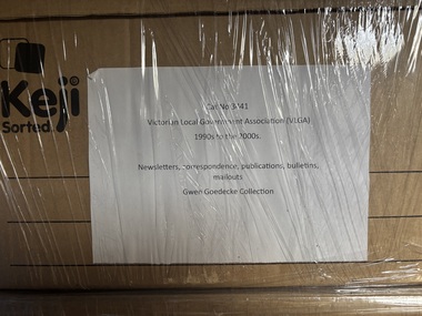
Archive - Gwen Goedecke Collection - Victorian Local Government Association (VLGA) Women's Participation in Local Government Coalition
... Victorian Local Government Association (VLGA) Bulletins (1994-2004) not complete years Newsletters on Gambling Research not complete years (2000-2002) Mailouts (1997 to 2002) not complete years - containing agendas, minutes General correspondence, planning days, notifications of events and the Mission Statement PUBLICATIONS: Newspaper - ' Local Government Focus' special feature (Oct 1986) VLGA review 2000 and 2003 VLGA - Resource Book ' - What Price Citizenship' (Feb 2002) Local Government of Engineers Association of Victoria - Symposium re 'The Minicipal Administration of Town Planning Schemes (1972) 'The Restructure of Local Government in Victoria - Northern and Western Melbourne Segment -Options Paper' - (1986) by the Local Government Commission Brimbank Council - 2003/04 Community Grants Program, Guidelines and Information VLGA/Stegley Foundation 'Building Partnerships between Councils and their Communities' (2000) VLGA - Resource Book - 'It takes a Village to Raise a Child' (2003) Department of Local Government and Administration Services - 'Developments in Local Government - Community Development, Human Services and Local Government' (1986) Women's Participation in Local Government |Local Government Conference ' 21st Annual Conference' programme - October 1986, by the Australian Local Government Women's Association, Victorian Branch Victorian Local Government Women's Charter ' Call for Submissions' - Women's Planning Network (Melbourne) - October 1997 |Women's Participation in Local Government Coalition - Candidates Information Pack, Council Elections, March 2003|Bulletin - Strengthening Communities through Women's Participation Project, Update December 2003 by the Women's Participation in Local Government Coalition RE: the Women's Charter|'Moving On' Women and Retiremnt from Victorian Local Government - Women's Participation in Local Government Coalition (203)|VLGA Bulletin - February 2004, 'Women's Charter Launched'...Women Victorian Local Government Association (VLGA) Bulletins (1994-2004) not complete years Newsletters on Gambling Research not complete years (2000-2002) Mailouts (1997 to 2002) not complete years - containing agendas, minutes General correspondence, planning days, notifications of events and the Mission Statement PUBLICATIONS: Newspaper - ' Local Government Focus' special feature (Oct 1986) VLGA review 2000 and 2003 VLGA - Resource Book ' - What Price Citizenship' (Feb 2002) Local Government of Engineers Association of Victoria - Symposium re 'The Minicipal Administration of Town Planning Schemes (1972) 'The Restructure of Local Government in Victoria - Northern and Western Melbourne Segment -Options Paper' - (1986) by the Local Government Commission Brimbank Council - 2003/04 Community Grants Program, Guidelines and Information VLGA/Stegley Foundation 'Building Partnerships between Councils and their Communities' (2000) VLGA - Resource Book - 'It takes a Village to Raise a Child' (2003) Department of Local Government and Administration Services - 'Developments in Local Government - Community Development, Human Services and Local Government' (1986) Women's Participation in Local Government |Local Government Conference ' 21st Annual Conference' programme - October 1986, by the Australian Local Government Women's Association, Victorian Branch Victorian Local Government Women's Charter ' Call for Submissions' - Women's Planning Network (Melbourne) - October 1997 |Women's Participation in Local Government Coalition - Candidates Information Pack, Council Elections, March 2003|Bulletin - Strengthening Communities through Women's Participation Project, Update December 2003 by the Women's Participation in Local Government Coalition RE: the Women's Charter|'Moving On' Women and Retiremnt from Victorian Local Government - Women's Participation in Local Government Coalition (203)|VLGA Bulletin - February 2004, 'Women's Charter Launched' Bulletins, newsletters, mailouts, general correspondence, publications 1994 - 2000's Archive Gwen Goedecke Collection - Victorian Local Government Association (VLGA) Women's Participation in Local Government Coalition ...Victorian Local Government Association (VLGA) Bulletins (1994-2004) not complete years Newsletters on Gambling Research not complete years (2000-2002) Mailouts (1997 to 2002) not complete years - containing agendas, minutes General correspondence, planning days, notifications of events and the Mission Statement PUBLICATIONS: Newspaper - ' Local Government Focus' special feature (Oct 1986) VLGA review 2000 and 2003 VLGA - Resource Book ' - What Price Citizenship' (Feb 2002) Local Government of Engineers Association of Victoria - Symposium re 'The Minicipal Administration of Town Planning Schemes (1972) 'The Restructure of Local Government in Victoria - Northern and Western Melbourne Segment -Options Paper' - (1986) by the Local Government Commission Brimbank Council - 2003/04 Community Grants Program, Guidelines and Information VLGA/Stegley Foundation 'Building Partnerships between Councils and their Communities' (2000) VLGA - Resource Book - 'It takes a Village to Raise a Child' (2003) Department of Local Government and Administration Services - 'Developments in Local Government - Community Development, Human Services and Local Government' (1986) Women's Participation in Local Government |Local Government Conference ' 21st Annual Conference' programme - October 1986, by the Australian Local Government Women's Association, Victorian Branch Victorian Local Government Women's Charter ' Call for Submissions' - Women's Planning Network (Melbourne) - October 1997 |Women's Participation in Local Government Coalition - Candidates Information Pack, Council Elections, March 2003|Bulletin - Strengthening Communities through Women's Participation Project, Update December 2003 by the Women's Participation in Local Government Coalition RE: the Women's Charter|'Moving On' Women and Retiremnt from Victorian Local Government - Women's Participation in Local Government Coalition (203)|VLGA Bulletin - February 2004, 'Women's Charter Launched'women -
 Warrnambool and District Historical Society Inc.
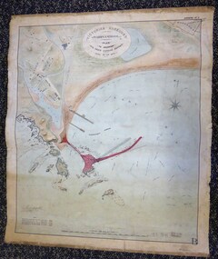
Map - Warrnambool Port 1879, 1879
... local agitation for some sort of Breakwater to be built and an Andrew Kerr design was approved by the Warrnambool Council but no funds were made available from the Victorian Government. Throughout the 1870s the building of a Breakwater was a major political issue in the district with preliminary work being funded and started in 1874. In 1879 the Government agreed to a further inspection of the area and an official report. Sir John Coode (1816-1892) was commissioned...local agitation for some sort of Breakwater to be built and an Andrew Kerr design was approved by the Warrnambool Council but no funds were made available from the Victorian Government. Throughout the 1870s the building of a Breakwater was a major political issue in the district with preliminary work being funded and started in 1874. In 1879 the Government agreed to a further inspection of the area and an official report. Sir John Coode (1816-1892) was commissioned ...The port facilities in Warrnambool Bay were in constant use from the first years of Warrnambool’s settlement but there were also difficulties for the shipping trade – a small and unsafe anchorage, the lack of loading facilities and little natural protection from the southerly gales. From the 1870s on there was local agitation for some sort of Breakwater to be built and an Andrew Kerr design was approved by the Warrnambool Council but no funds were made available from the Victorian Government. Throughout the 1870s the building of a Breakwater was a major political issue in the district with preliminary work being funded and started in 1874. In 1879 the Government agreed to a further inspection of the area and an official report. Sir John Coode (1816-1892) was commissioned to make this report. He had come to Australia in 1872 to advise on harbour construction. Coode recommended a 1800 feet long Breakwater and wharf connected to the shore and it was this proposal that the plan described herein and drawn up in 1879 was to accompany. The original plan was eventually modified because of the cost and a Breakwater was completed in 1890 under the direction of the engineer, Arthur Dudley Dobson, with extensions early in the 20th century. This plan is of great interest as it shows in simple graphic form the original plans proposed by Sir John Coode for the Warrnambool Breakwater. It is therefore of great historical importance. The Breakwater was not the maritime success that it was hoped it would be but it is today a significant feature of our foreshore. This is a Plan drawn up in 1879 by Victorian Harbours to accompany Sir John Coode’s Report on the proposed Warrnambool Breakwater. The chart detail is hand-drawn and hand-tinted on canvas with the names of places, geographical and marine features and local points of interest added in print. The edges of the chart are rubbed and the chart is somewhat faded and dirty but the main colours of red, green and brown are still clearly discernible. The title of the plan is printed in an oval inset at the top of the chart. The plan shows two possible Breakwater designs, one from the Borough Surveyor (Andrew Kerr?) and one from Sir John Coode.Victorian Harbours Warrnambool Plan to accompany Sir John Coode’s report Dated 28th Feby 1879 warrnambool breakwater, andrew kerr, sir john coode, arthur dudley dobson, warrnambool, warrnambool harbour, warrnambool history, warrnambool beach -
 Kiewa Valley Historical Society
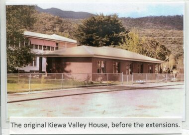
Photographs- Kiewa Valley House (before and after extensions) & Tawonga District General Hospital- Set of 6 colour photographs
... On June 6th, 1980, an appeal to finance a 12 bed nursing wing was launched at a public meeting in Mount Beauty The Hospital and Charities Commission’s development board finally approved the application for government funds to build the 12 bed nursing home in early 1981. The official opening of the nursing home was on March 6th, 1985. Opening of the lounge extensions occurred in May, 1993 Many local ...The establishment of Kiewa Valley House, was a significant victory for residents and senior citizens in the Kiewa Valley district. Plans were laid in the mid 1970’s and a proposal was formulated for a 12 bed unit nursing home to be attached to the Tawonga District General Hospital. The need for an aged care facility in Mount Beauty was prompted by recognition of the high ratio of senior citizens residing in the area. At the time residents had to travel to Beechworth, Wangaratta or Wodonga for care. On June 6th, 1980, an appeal to finance a 12 bed nursing wing was launched at a public meeting in Mount Beauty The Hospital and Charities Commission’s development board finally approved the application for government funds to build the 12 bed nursing home in early 1981. The official opening of the nursing home was on March 6th, 1985. Opening of the lounge extensions occurred in May, 1993 Many local residents have taken advantage of facilities at Kiewa Valley House when they became unable to manage independently in their own homes. This has meant they did not have to face the stress of leaving the area and being separated from their local family and friends. Many SEC workers and their families have been residents of Kiewa Valley House over the years.Set of 6 colour photographs of Kiewa Valley House and original Tawonga District General Hospital in Mt Beauty 1 Kiewa Valley House, before extensions, with old weatherboard hospital in background 2 & 3 Official opening of Kiewa Valley House. 4 & 5 Gardens between Kiewa Valley House and Hospital 5. Kiewa Valley lounge extension 1. The original Kiewa Valley House, before extensions 2. No markings 3. No markings 4. View of the gardens between the weatherboard hospital and Kiewa Valley House 5. Walkway between Hospital & Kiewa Valley House 6. Kiewa Valley House Lounge Room extension tawonga district hospital, kiewa valley house, mt beauty district hospital -
 Kiewa Valley Historical Society
Papers - Falls Creek Tourist Area Management Committee, August 1984
... Commission of Victoria came into effect in 1959 and from then on building sites were leased and building and sewerage controls were applied. In 1979 the Victorian State Government had established the Ski Industry of Victoria working party with a brief report on its operation. These papers give an insight into the business of the Falls Creek Chamber of Commerce in 1984 eg. car parking, noise, closure of the resort due to heavy snow falls, the media and general development of the resort. Local ...Falls Creek is a ski resort in the north east of Victoria on the Bogong High Plains. Members of business's (accommodation & restaurants) formed the Falls Creek Chamber of Commerce to promote tourism 'under' the Falls Creek Tourist Area Management Committee. The Falls Creek Tourist Area Management Committee under the direction of the State Electric Commission of Victoria came into effect in 1959 and from then on building sites were leased and building and sewerage controls were applied. In 1979 the Victorian State Government had established the Ski Industry of Victoria working party with a brief report on its operation. These papers give an insight into the business of the Falls Creek Chamber of Commerce in 1984 eg. car parking, noise, closure of the resort due to heavy snow falls, the media and general development of the resort. Local business people are named as attending the meeting indicating many non English surnames. 4 yellowed papers typed on both sides of the first 3 pages. irst paper has 6 items listed re Falls Creek Chamber of Commerce / Sub Committee on General Booking Conditions.Dated 15th August 1984 Next 3 papers dated 13th August 1984 Falls Creek Chamber of Commerce / Minutes of General Meetingfalls creek, ski resort, bogong high plains, falls creek chamber of commerce, snow, ski lodges, -
 Kiewa Valley Historical Society
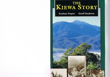
Book - Non Fiction History, The Kiewa Story, circa 1993
... Commission of Victoria. The impact on the social, financial and individual independency of the community, by the transition from the S.E.C .environment to one of local government (Shire of Bright), had in some cases a severe impact. kiewa valley hydro scheme victorian alpine region electricity generators graham napier geoff easdown Book spine: "The Kiewa Story Graham Napier Geoff Easdown" alongside this is a white framed circle with white spokes radiating out and underneath in white lettering SEC This hard covered book has a green cover with pictures on the front and back covers. ...This book provides in chronological order the development of the Kiewa Hydro-electricity scheme from the first concept (1911) to final construction work (1961). It covers the first attempt to utilise the power of the Victorian Alps water system. It started from a private syndicate and developed to the current State Electricity Commission of Victoria. The incentive for the Hydro scheme was to make money and not as an alternative to the carbon producing coal fired power plants. These coal fired power plants were increasing in numbers to service an ever increasing demand made by population expansion, especially in cities and large rural settlements. This demand spiraled up after World War II when there was a tremendous spike in immigration numbers due to refugees and displaced persons in Europe. The ability to utilise the untapped water provided by the winter snow fields, for a higher yield in electricity, was a powerful incentive to overcome the physical hardships in this remote Alpine region. Future power requirements may initiate the re-installation of the other two power stations(Pretty Valley and Big Hill) covered in original Scheme. This publication not only covers the development of the Kiewa Valley region with respect to population (within a socio-economical framework) but also the subtle but yet strong physical changes of a relatively pristine alpine region. The demands that an ever growing regional population places on the environment is clearly documented in print and black and white photographs. The working and living conditions of those who constructed and gave life to this hydro scheme is well documented in this book. It may be viewed as spartan now but was relevantly good at that moment in time, especially for those workers fleeing a devastated European environment. The successful planning and consideration to minimising any intrusion upon the natural alpine forests and high plains can viewed as an example (compared to the Tasmanian Hydro schemes) of how future hydro schemes (an inevitable requirement) will proceed. Most rural towns (in the early 1900s) were built by unencumbered rural based citizens, with the exception of Mount Beauty and Falls Creek. These two settlements were brought into life by a State (Victorian) Authority for a specific function and program. They were a gated community, that is, only open to construction workers involved with the hydro scheme. All facilities within these communities were provided by the State Electricity Commission of Victoria. The impact on the social, financial and individual independency of the community, by the transition from the S.E.C .environment to one of local government (Shire of Bright), had in some cases a severe impact.This hard covered book has a green cover with pictures on the front and back covers. The front cover has a coloured picture of a snow covered Mount Bogong taken from the opposite mountain range. The valley between both ranges has a whisk of mist over it. At the bottom of this picture are three black and white photographs covering the construction of the Kiewa Hydro - Electricity Scheme. On the back cover is a photograph, (black and white) detailing the Bogong village and Junction dam containing lake Guy. The inside front cover is a black and white photograph which details the construction of the West Kiewa tailrace tunnel during April 1951. The inside back cover is a black and white photograph of the concrete pour at the Clover Dam circa 1952. All photographs and sketches are in black and white. The pages are approximately 160 g/m2 and those which have photographs are on gloss paper.Book spine: "The Kiewa Story Graham Napier Geoff Easdown" alongside this is a white framed circle with white spokes radiating out and underneath in white lettering SECkiewa valley, hydro scheme, victorian alpine region, electricity generators, graham napier, geoff easdown -
 Kiewa Valley Historical Society
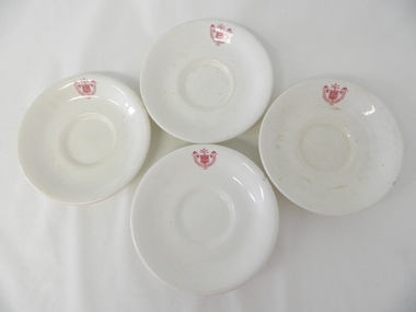
Saucer Ceramic, from 1921 to 1961
... government organisations were still tied to the "establishments" of "mother" England. It was a period in Australia's development when the Asian influence was very weak and the established ties to England and Europe was still very strong. The majority of heavy equipment and machinery was either made in England or Europe. Local/European expertise in dam construction and water management in alpine terrain came from migrants or English and European specialist. The quality of workmanship from big steel manufacturing plants in England and Europe could not be matched from anywhere else in the developed world. saucer plate secv state electricity commission ...This item was used by the State Electricity Commission of Victoria in their mess rooms for their workers during the construction of the Kiewa Hydro Electricity Scheme. The imprint of the year "1921" was to identify the year that the SECV was formed and relieved the private VHEC(Victorian Hydro-Electric Company). As the scheme was of such a huge, isolated and time consuming nature the feeding of its workers was quite demanding of cutlery and crockery. The use of sturdy English cups and saucers was essential. The period of construction and the isolation of the Kiewa Valley area placed heavy demand for "solid" crockery that could wear abusive handling. This period in time was one when crockery, whether for domestic or commercial use, was imported from "mother" England. This scenario was more so for governmental bodies such as rail, jails and electricity providers than domestic users. The influx of cheaper Asian crockery had not yet begun.This type of crockery item was used by the thousands of SEC Victorian staff and construction workers involved in the building of the Kiewa Hydro Electricity Scheme, over the extensive period (1938 to 1961). This was a period when Government bodies and other semi- government organisations were still tied to the "establishments" of "mother" England. It was a period in Australia's development when the Asian influence was very weak and the established ties to England and Europe was still very strong. The majority of heavy equipment and machinery was either made in England or Europe. Local/European expertise in dam construction and water management in alpine terrain came from migrants or English and European specialist. The quality of workmanship from big steel manufacturing plants in England and Europe could not be matched from anywhere else in the developed world.This item is a white ceramic saucer (tea /coffee). It is made in England and is of strong and durable ceramic. The bottom cup indent is for either tea or coffee cups of a similar ceramic structure. The 5mm thickness of the ceramic suggests this saucer belongs to a commercial kitchen environment and not domestic. The indent bottom of the saucer is 5mm deep with a side curvature ratio of 2:5. The ceramic is glazed to a commercial standard (worker's mess). See also KVHS 0128 (A,C and D) The seal of the State Electricity Commission Of Victoria is imprinted on the top inside rim within a curved scroll. Snuggled within the borders of the scroll is a banner with the five stars of the southern cross and an arm with a closed fist projecting from the top with five lightning bolts projecting outwards. On the underside "Vitrified sold by Cafe & Hotel Supplies Pty Ltd Dunn Bennett & Co. Ltd. Burslem Made in England"saucer, plate, secv, state electricity commission of victoria, crockery, mt beauty chalet, bogong mess hall -
 Kiewa Valley Historical Society
Plate Bread & Butter, Circa 1921
... government organisations were still tide to the "establishments" of "mother" England. It was a period in Australia's development when the Asian influence was very weak and the established ties to England and Europe was still very strong. The majority of heavy equipment and machinery was either made in England or Europe. Local expertise in dam construction and water management in alpine terrain came from migrants for England and Europe. The quality of workmanship from big steel manufacturing plants in England and Europe could not be matched from anywhere else in the developed world. saucer plate secv state electricity commission ...This item was used by the State Electricity Commission of Victoria in their mess rooms for their workers during the construction of the Kiewa Hydro Electricity Scheme. The imprint of the year "1921" was to identify the year that the SECV was formed and relieved the private VHEC (Victorian Hydro-Electric Company). As the scheme was of such a huge, isolated and time consuming nature the feeding of its workers was quite demanding of cutlery and crockery. The use of sturdy English cups and saucers was essential. The period of construction and the isolation of the Kiewa Valley area placed heavy demand for "solid" crockery that could wear abusive handling. This period in time was one when crockery, whether for domestic or commercial use, was imported from "mother" England. This scenario was more so for governmental bodies such as rail, jails and electricity providers than domestic users. The influx of cheaper Asian crockery had not yet begun.This type of crockery item was used by the thousands of SEC Victorian staff and construction workers involved in the building of the Kiewa Hydro Electricity Scheme, over the extensive period (1938 to 1961). This was a period when Government bodies and other semi- government organisations were still tide to the "establishments" of "mother" England. It was a period in Australia's development when the Asian influence was very weak and the established ties to England and Europe was still very strong. The majority of heavy equipment and machinery was either made in England or Europe. Local expertise in dam construction and water management in alpine terrain came from migrants for England and Europe. The quality of workmanship from big steel manufacturing plants in England and Europe could not be matched from anywhere else in the developed world.This item is a white ceramic plate (bread & butter). It is made in England and is of strong and durable ceramic. The bottom of the plate is flat with edges sloping out (to position the bread) and the extended rim is to catch any spillages. The 5mm thickness of the ceramic suggests this plate belongs to a commercial kitchen/eating establishment (mess) and not a domestic dining room. The indent bottom of the plate is 5mm deep with a side curvature ratio of 2:5. The ceramic is glazed to a commercial standard (see KVHS 0128 for its saucer part of a dinner set.The seal of the State Electricity Commission Of Victoria is imprinted on the top inside rim within a curved scroll. Snuggled within the borders of the scroll is a banner with the five stars of the southern cross and an arm with a closed fist projecting from the top with five lightning bolts projecting outwards. On the underside "Vitrified sold by Cafe & Hotel Supplies Pty Ltd Dunn Bennett & Co. Ltd. Burslem Made in England"saucer, plate, secv, state electricity commission of victoria, crockery -
Federation University Historical Collection
Document, Zelda Martin, Central Victorian Goldmining towns - Boom Towns or Ghost Towns?, c1996
... Commission to Enquire into Sludge 1859...E.S. Parker...Edward Stone Parker...Edgar Morrison...Mount Franklin Protectorate...Dja Dja Wurrung...Memorial Cairn...Franklinford...Mt Franklin Memorial Cairn...jajowurrong...dja dja wurung...tjaowarong...wothowurong...assistant protectors...daylesford museum...buluk...rock art - grampians...aboriginal mythology - grampians...aborigines...first nations people...mount franklin...aboriginal artifacts...lake burrumbeet...native police force...central board of aborigines...yandoit...Commissioners' Reports...Wardens' Reports...Port Phillip/Victoria Directories 1839-1867...Local Government...Bibliography *Australia's Mining History * Bibliography - Land Surveys Victoria - *1853 Administration (Statistics and Other) includes: schools / ministers of religion / police / military / local administration / licences for sale of spirits / distances between various Victorian gold fields. * Victoria Government Gazette (Copy) - N0. 116, 12/12/1854 includes: Gold Felds Commission of Enquiry & No. 85, 15/09/1854 - Addresses presented to the Lieutenant Governor (Sir Charles Hotham) during his tour through the Gold Fields of Victoria,1854. ...Bibliography *Australia's Mining History * Bibliography - Land Surveys Victoria - *1853 Administration (Statistics and Other) includes: schools / ministers of religion / police / military / local administration / licences for sale of spirits / distances between various Victorian gold fields. * Victoria Government Gazette (Copy) - N0. 116, 12/12/1854 includes: Gold Felds Commission of Enquiry & No. 85, 15/09/1854 - Addresses presented to the Lieutenant Governor (Sir Charles Hotham) during his tour through the Gold Fields of Victoria,1854. ...Zelda Martin was a PhD candidate at the University of Melbourne.[.1] 4th item in light blue display book titled Research Approach/Overview of Chapters/Confirmation of Canditure/Chapters1,2,3&4 of proposed thesis. *Twenty-seven page article on Victorian goldfields towns titled: Central Victorian Goldmining Towns - Boom Towns or Ghost Towns. The article was written during the author's PhD study. It outlines the context methodology, and resources and the chapters of the proposed thesis: (1) Central Victorian Goldmining Towns - The Context (2) Contemporary Views of the Factors Necessary for Town Growth (3) Outward Manifestations of Town Growth (4) The Trappings of Government (5-9) The Main Towns and Their Hinterland. [.2] 5th item in Light Blue display book as above item. *Chapter 1 of proposed thesis titled 'Pick, Shovel and Tin Dish Mining.' Covers in Section A: Central Victoria - Pre 1851: Aborigines in Central Victoria, Squatters, and Government. Section B: The years 1851-1854: The Early Gold Rushes, Government Reaction, Township Surveys, Legislation, Town Development, Local Government and Early Settlement. [.3] 6th item in Light Blue display book as above item. *2A of proposed thesis titled 'Contemporary Views of the Factors Necessary for Town Growth'. Similar information to Chapter 1 plus extra re towns and maps. Sections: Introduction, Context of Place - Geographical Towns Listed, The Context of Time - Pre1851 Aborigines, Governance of Port Phillip, The Squatters, The Villages of Central Victorian Highlands, Conclusion, Condensed Version of Chapter2B. [.4] 7th item in Light Blue display book as above item. *Chapter2B of proposed thesis. Sections: Area of Research, Schools, Banks, Newspapers, Progress Association, Town Development - Sandhurst (Bendigo), Ballarat, Castlemaine,, Maryborough, Ararat and Stawell. [.5] 8th item in Light Blue display book as above item. *Chapter 3 of proposed thesis titled 'Outward Manifestations of Town Growth'. Sections: Introduction, Contemporary Writing, Educationalists, The Bankers, The Townsfolk, Current Theory, General Theories of Urban Development, and Conclusion. [.6] 9th item in Light Blue display book as above item. *Chapter 4 of proposed thesis titled 'Trappings of Government' Sections: Introduction, Early Government Attitudes to Mining and Town Development, Law and Order, Township Surveys, Legislation, Local Government, Transport and Communication, The People and Lobbyists. [.7] 10th item in Light Blue display book as above item. *'The Rise and Fall of Central Victorian Goldmining Towns'. Includes a map showing main Goldfields, a table showing towns and villages at two points in time - 1857 and 1871; a Bibliography of Primary and Secondary Sources. [.8] Resource No1. Black display book titled Local Towns 1 : Alma: *Brief history *Directory *Maps Amphitheatre / Mountain Hut: *Brief History Post Office Directory Ararat: *Brief History *Post Office Directory 1869 - Alphabetical Listing by Occupation *Ararat - Prominent Citizens of 1858 *Langi-Morgala Museum Avoca: *Brief History *Excerpts from 'Avoca The Early Years', Margery and Betty Beavis; pg1 - Beginnings; pg11 - The Midas Touch; pg25 - Local Gold Escorts; pg27 - A Town is Born; pg51- The Administration of Justice; pg53 - The Ways of the Law; pg61 - News of the Day; pg65 - A Time to Play; pg72 - Land Ownership *Post Office Directory (Bailliere's) 1869 *Tourism Map and Information of area *Historic Avoca - A 5.5km Tour *Avoca & the Pyrenees Region - information pamphlet Ballarat: *Early History of Ballarat - Ballarat Historical Society, Publication No.1: origin of the name; Ballaarat - the Beginning; Fabulous Yields from the Ballaarat Goldfield; *Streetscape Lydiard Street. *Hand drawn map showing Leigh River, Old Portland Bay Road, plaque on road to Colac; etc. *Newspaper article re 'The Theatre Royal' ( which stood in the vicinity of the current Owen Williams store) - 'The News'15/04/1998 *Article - 'Ballarat's Mechanics' Institute Lives On' Ballarat Courier, 14/09/1985 *Article - Standing the Test of Time' The News 17/11/1993 re The Mechanics Institute & picture of the Reading Room *'Ballarat a Study of a City, Phyllis Reichl, pub. Nelson, 1968; no.3 place, time and people field studies series *Investigator Vol.33 No.2, 1998 Geelong Historical Society. Article on pg75 describes Ballarat in 1861 *Folded poster - 'Ballarat 100' a history of telegraph communication, pub. Telecom. Beaufort (Fiery Creek): *Brief history *Post Office Directory [.9] Resource No.2 Black Folder Titled Towns cont.No2 Bendigo (Sandhurst): *'Family & Local History at the Bendigo Library - 1851-2001 150 years of gold'. *Bendigo Government Camp in 1853 illustration; key to sketch and names of Government officers stationed there *Excerpts from 'Bendigo and Vicinity' Adolph Haman *The Bendigo Goldfield Registry - pgs 1-7 Introduction *Excerpt: 'Breaking the Grip' *Excerpt: The Most Go-Ahead Place *Excerpts from 'History of Bendigo' - anti license agitation; laying out of town; proposed railway; gold calls and dividends; the Sandhurst Municipality; journalism *Bibliography Blackwood: *Excerpts from 'Aspects of Early Blackwood - The Goldfield, the Landmarks, the Pioneers' Alan J Buckingham and Margaret F Hitchcock, JG Publishing,1980 Buninyong: *A Brief History *Investigator Vol1 No.2 Feb 1966 Geelong Historical Society. Pg3 - Article re gold escort route - Mt Alexander to Adelaide - (see a simple monument on the Western Highway a few miles out of Horsham. Pg 15 - Ballarat Excursion - re the finding of gold. *Three articles published by Buninyong and District Historical Society Inc: (Magpie Exploration; Finding Gold In The Green Hills; Magpie Exploration; Burnt Bridge to Cargarie to Mt Mercer) *Copies of newspaper articles/items *Buninyong Street Directory Carisbrook: *In the Beginning There Was Carisbrook *The History of the Carisbrook Racecourse Carngham / Snake Valley: *Brief History *Directory Castlemaine: *Directory 1865-1866 - Alphabetical and Street *Poster - Castlemaine A Contemporary Guide "The Great Centre" 1866 - A Contemporary Guide to the Fascinating Past *Pamphlet - Castlemaine District Community Hospital *Map - Castlemaine, Maldon & Surrounding Districts *Map and Information - The Dry Diggings Track - a 55kl walk among historic goldfields relics ( Castlemaine Fryerstown Vaughan Mt Franklin Hepburn Daylesford) *Postcard - Former Court House *Directory 1867 - Alphabetical, Trade [.10] Resource No.3 Grey folder Titled Towns 3 Creswick to Maryborough Creswick: *Brief History *Booklet - "Creswick Cemetery Walk" *Booklet - The Buried Rivers of Gold Heritage Trail Creswick *Creswick Historical Museum Information Sheet *Chronological History of Creswick *Alphabetical Directory of the Borough of Creswick *Creswick's Creek Directory 1856 *Historic Creswick Walking Tour *A Brief Account of the Schools of Creswick - Past and Present *100 Years of Railway Travel in Creswick *The Berry Deep Leads *The Spence Home at Jackass Gully in the Creswick State Forest ( William Guthrie Spence - Pioneer) *The New Australian Mine and the 1882 Disaster *Creswick District News, Issue 7, July August 1999 *The Creswick Miners Walk - Information and Map *Maps Chewton: *Brief History *Directory Clunes: *Brief History *Clunes Street Directory Daylesford: *Brief History *Notable Bushfires in Daylesford District Over More Than a Century - "Black Thursday" 1851; 1862; 1899; the Disastrous Hepburn Fire of 1906; 1939; 1944; 1969. *Post Office Directory -Daylesford and Hepburn Dunolly / Inkerman: *Brief History *Directory *Pamphlet - Goldfields Historical Museum *Pamphlet - Historic Dunolly - Victoria's Best Kept Secret *Map of Gold Workings at Dunolly Area - showing where the main gold rushes occurred *Brief History - Inglewood *Directory - Inglewood - Name Occupation, Dwelling Kingower: *Brief History *Directory - Name / Ocupation / Dwelling Linton / Happy Valley / Piggoreet: *Brief History *Directory - Lintons McIvor: *"A History of the Shire and the Township of Heathcote" by J.O. Randell Majorca: *Brief History *Official Post Office Directory 1869 - Name / Occupation/ Address Maldon (Tarrangower): *Brief History Part 1 *Brief History Part 2 *Post Office Directory *List - Alphabetical Order by Names plus Business and Trade (Tarrangower Times Oct/1858) *List - Alphabetical Order by Trade plus Name and Business *Directory - Name / Occupation / Dwelling Maryborough: *Worsley Cottage - built by Arthur Worsley, a contractor in stonework in 1894 [.11] Resource No. 4 Blue Display Book titled Towns 4 Moliagul to Stawell Moliagul: *Brief History *Moligul Legislative Assembly (Voting?) List - Names and Occupations *Moliagul Victorian Post Office Directory 1868 - Name / Ocupation / Address / Comments *"The Welcome Stranger" gold nugget *The Sunday School *The Welcome Stranger Discovery Walk - information and map Moonambel (Mountain Creek) Redbank *Brief History *List of names extracted from advertisments of the Pioneer and Mountain Creek Advertiser 16/02/1861. *Bailliere's Directory 1869 - Alphabetical List of Name / Occupation / Place St Arnaud: *Brief History Sebastapol: *Brief History *Directory 1869 - Alphabetical by Name; plus occupation and address. Browns and Scarsdale: *Brief History *Browns Street Directory - Name and Occupation Smythesdale: *Brief Description *Smythesdale Street Directory -Name and Occupation Stawell (Pleasant Creek) *Brief History *Victorian Official Post Office Directory - Name /Occupation / Dwelling *Chronology - 1841-1920 *Production of gold statistics - 1879 - 1900 *Big Hill *Extracts from "The Golden Years of Stawell". Chapt 1 - Stawell's Coming Out. Capt. 2 - The Gold Rush. Caapt.3 - Cradle of Democracy. Chapt.4 - The Reefs Becomes Stawell. Chapt. 5 - Rushing In. Chapt.6 - The Pioneers. Chapt 7 - The Decade of Optimism. [.12] Resource No. 5: Blue Display Book titled 'Towns Steiglitz to the The Golden Triangle. Steiglitz: Brief History Victorian Post Office Directory 1869 *Map of Steiglitz *List of maps relevant to Steiglitz history *Information 6 tables of data from "Reports of Mining Surveyors Talbot (Back Creek) Brief History Taradale: Post office Directory 1869 - Name/Occupation/Street. Also list in alphabetical order by Occupation Taradale *Chronological Reference to Taradale Mines *Water - The Coliban System of Waterworks *Joseph Brady *The Syphon Tarnagulla (Sandy Creek) *Brief History *Tarnagulla Businessmen Cameos to give depth to advertisments in 'The Tarnagulla Courier' various issues 1864-1871 *Directory - Name/Occupation /Address *List - Name/Business/Trade Wedderburn (Koorong) *Brief History *List - Name/Occupation The Golden Triangle: *The Early Rushes - Wedderburn / Moliagul / Sandy Creek - Tarnagulla / Jones Creek - Waanyarra / Kingower / Dunolly - Goldsborough / Inglweood *Census of 1857 - Population / Occupations *1858-1871 - A Time of Consolidation- Wedderburn / Moliagul / Sandy Creek- Tarnagulla / Arnold *Census 1871 - Population *Information gleaned from the census data - Demographics / Population / Occupations / marital / Birthplace / Religion / Literacy/ Occupation and Housing Cameos *Graphs - Birthplace of settlers /Male-Female Ratio / Married males / Children under 15 as Percentage of Population / Religion *Census 1857 - Statistical data *Maps *Bibliography [.13] Resource No. 6 - Black Display Book Information and Research in Central Victoria including: *Banking - Research from ANZ Bank Archives *Institutions - also includes articles listed from the Ballarat Times Newspaper *Australian mining History Association - A.M.H.A. Bibliography *Australia's Mining History * Bibliography - Land Surveys Victoria - *1853 Administration (Statistics and Other) includes: schools / ministers of religion / police / military / local administration / licences for sale of spirits / distances between various Victorian gold fields. * Victoria Government Gazette (Copy) - N0. 116, 12/12/1854 includes: Gold Felds Commission of Enquiry & No. 85, 15/09/1854 - Addresses presented to the Lieutenant Governor (Sir Charles Hotham) during his tour through the Gold Fields of Victoria,1854. Addresses on behalf of : the people of Bendigo; Members of the Church of England, Bendigo; Members of the Wesleyan Church on the Bendigo Gold Fields; Bendigo Gold District General Hospital; the Bendigo Prospecting Association; Committee of the Bendigo Local Exhibition; Bendigo District Medical Association; Coloured Americans Resident at Bendigo; German Inhabitants of Bendigo; Landowners, Inhabitants, and Miners of Castlemaine; Inhabitants of Forest Creek; Inhabitants of Heathcote and Gold Miners of McIvor; Residents and landholders of the District of Bacchus Marsh; Inhabitants of Kilmore and Vicinity. *Gold Fields Correspondence 1853: letter from Lieutenant Colonel Valiant, (Officer commanding the Troops in Victoria) to the Lieutenant Governor re threatened disturbance at Sandhurst (Bendigo) regarding the Gold License Fee. * Extracts from a book "Victoria" re Gold Fields Commission of Enquiry involving mainly Ballarat and Castlemaine and a chapter titled 'A Tour to the Victorian Gold-Fields' *Lists of central Victorian newspapers - listed by date published 1851to 1874; by first date available to State Library. *A list of cities and towns showing County, population in 1861 &1871, and municipal status. [.14] Resource no.7. Black display book. *Reference: Papers presented to Parliament Victoria - 1859-1860 4 volumes - relevant sections copied. Contains information on Branches of Government. General / Finance / Gold / Gazette / Commission and Warrant / Statistic. *Gold Fields Act. In accordance with the Act the gold fields are divided into six districts - Ballaarat, Castlemaine , Sandhurst, Avoca, Ararat, and Beechworth.. Official staff in each gold district consists of a Resident Warden, Wardens, Wardens' Clerks, Bailiffs, Chinese Protectors, Chinese Interpreters, and Mining Surveyors. *Gold Receiver *Gaols *Police magistrates and Clerks of Petty Sessions, etc. *Field Branch *Immigration and Emigration Overland - Chinese - 1859 *Population on the Goldfields *The Geological Survey - The Government Geologist is assisited by staff from four branches - the office Branch; the Publishing Branch; the Field Branch and the Museum Branch. *Commission to Enquire Into Sludge dated 10/02/1859 (Some sections copied) - Report to the Honorable Chief Commissioner of Public Works, Melbourne re the mode of carrying the sludge from the puddling mills in Sandhurst without interfering with the drainage of the town and the roads in the neighbourhood. [.15] Resource No.8: Camel display book titled Resource No. 8. Aborigines *Lists of book titles - +"Readings in Victorian prehistory" +"The Aborigines of Port Phillip" +Aboriginal languages and clans" +"A History of the Port Phillip District" +"Langi Ghiran 1: Aboriginal Rock...." +"Koorie History: sources for aboriginal studies in the State Library of Victoria", ed. Tom Griffiths, Melb. Friends of the State Library, 1989 +"The Public Lands of Australia Felix"; settlement and land appraisal in Victoria1834-91 with special reference to the Western Plains", J.M.Powell, Melb. Oxford University Press 1970 +*Bibliography of the Victorian Aborigines' from the earliest manuscripts to 31st December 1970, Massoa, Aldo, Melb. Hawthorn Press, 1971 +"Aborigines in Colonial Victoria, 1836-1886", M.F. Christie, Sydney University Press, 1979 +"Urban and Industrial Australia: readings in Human Geography" ed J.M. Powell, Melb. Sorrett Pub. 1974 *Extracts: -Processes of Pioneer Settlement - The Squatting Occupation of Victoria, 1834-60. J.M. Powell -Areal Variations in the Class Structure of the Central-Place Hierarchy. P. Scott - Volume1 and Volume 2: Notes Relating to the Habits of the Natives of Other Parts of Australia and Tasmania. Compiled from various sources for the Government of Victoria by R Brough Smyth. John Curry, O'Neil, Melb. 1st pub. Melb. 1876. p31-45 - Numbers and Distribution of the Aborigines in Victoria -Victorian Aborigines 1835-1901 - A Resource Guide to the Holdings of the Public Record Office, Victoria; published by the Government Information Centre 1984. *History of the Aboriginal Artefacts Displayed in the Daylesford Museum. F. G. Powell (4 page pamphlet) *Letter to Zelda Martin from Peter Lovett, Cultural Officer, Ballarat & District Aboriginal Co- Operative, 05/02/1997 *Map: Ian Clarke Victorian Tribunal Boundary Map - Clans of Central Victoria. *Victorian Rock Art and Mythology - Article about Mount Langhi Ghiran and myths of the Tjapwarong people. *Two Aboriginal myths relating to the Grampians - 'The Monster Emu' / 'The Aquisition of Fire', by the Aborigines in the Grampians Areas *Article titled (chapter 8) Ballarat - information re camping sites in the region. Lake Wendouree / Lake Burrumbeet (includes a myth) / Mt Bunninyong / Lal Lal / Pitfield / Mount Elephant / Mount Egerton / Meredith / Lake Goldsmith / Lake Learmonth / Ercildoune *Notes on the Aborigines of the Wider Ballarat Region plus European names=Aboriginal names. John Morris 26/07/1995 *Role of Aborigines in Town Development in Central Victoria. Mentions Native Police Force est. in Port Phillip 1842 and Central Board for Aborigines est. 1860 *The Grave of King Billy. (Frank Wilson) Pamphlet. *Camping Places in Central and Northern Victoria. Article re Lake Burrumbeet site. *Programme for the Unveiling of Memorial Cairn for Edward Stone Parker 1802-1865. Note portrait not accurate. Accurate portrait is available in the book "A Successful Failure A Trilogy The Aborigines and Early Settlers", Edgar Morrison, Graffiti Publications, 2002. * Large envelope addressed to Mr G Netherway containing newspaper cuttings regarding the life of Edward Stone Parker, the unveiling of the Memorial Cairn as mentioned above, articles titled 'Episodes from Our Early Days' (Edgar Morrison, Yandoit)- The Black's School, A School At Last and The Final years. Also a typed page titled 'Historical Background to E.S.Parker's Career. Includes an interesting tale titled 'When the cat lay doggo' re laying power leads for the unveiling ceremony at the memorial site. [.16] green display folder titled 'Research Aids' *List of references to Commissioners' & W'ardens' Reports (formerly held at La Trobe Library Archives, now at Public Records Office [PRO]). Indicates town referred to / date of report / name of camp if different to town. * Archive information re Anglican Records *Movement around the Goldfields - Miners and Storekeepers - usefulness of newspapers in providing information - areas covered - Castlemaine, Maldon, Ararat, Stawell, Tarnagulla, Dunolly. *Port Phillip /Victoria Directories 1839/1867 - Chronological list of Directories included in this series. *"Notes on the History of Local Government in Victoria" A.W. Greig Melb. University Press 1925 - Photo-copied extract p5-p40. (Source - Deakin University Library) - Introduction by W.Harrison Moore. Section 1 - Development in New South Wales Before Separation. Section 2 - Development in Victoria After Its Separation from New South Wales. Hand written notations: 'roads, markets, and local government 1855 on' ;'opportunity of squatters in parliament' and 'opportunities of matters in parliament p33' * Notes on the Establishment of Surveyor General's Department 1851and Commissioner of Crown Lands and Survey. * Newspaper articles from The Argus, 1849, re the discovery of gold in the Pyrenees region. * Excerpt - a report on schools - A.B.Orlebar, Inspector; re the need for permanent school buildings rather than tents. *Excerpt from - 'Approaches to Urban History', Sean Glynn: The Case for Caution * Except from - 'The Urban Sprinkle', Weston Bate: Country Towns and Australian Regional History *Reference- 'The History of Land Tenure in the Colony of Victoria', John Quick. References the Haines Land Bill, land tenure and Land Leagues. [.17] Light blue envelope folder titled 'Birtchnell's Ballarat, etc. Directory 1862 *Contains various directories for Smythesdale, Buninyong, Clunes, Brown's and Creswick. [.18] Red envelope folder no.2 titled Victorian Gazetteer *Selected pages from 1869 Victorian Gazetteer on A4 paper (with a handwritten note questioning if some pages are from 1868 Victorian Gazetteer as appears to be different sizes - A3 pages.) Information includes locations and descriptions of towns, hotels, banks, communications and populations. (Does not include names, residences and occupations) [.19] Red Envelope folder titled Bailliere's Official Post Office Directory 1868 (or1869 or a mixture of both?) *Preface *Contains a selection of pages of towns highlighted in yellow in the the index *Work on this directory was commenced in 1867. *Information includes: Municipalities - mayors and councilors; lists of towns naming male inhabitants and their occupations. [.20]Yellow manila folder titled Post Grad Seminar Presentation 1996 *Gives some background to Zelda Martin's proposed thesis and why she chose the topic Gold Mining Towns Boom or Bust [.21] A3 display book - No. 1A * A list of 'Relevant Newspapers collected: The Tarrangower Times and Maldon Advertiser (first published 1858) Includes dates 1858-1867. The Mount Alexander Mail. Includes dates 1854-1866 The Tarnagulla Courier. Includes dates from1864-1871 Dunolly and Burnt Creek Express. Includes dates from 1862-1871 * Selection of newspaper pages from The Mount Alexander Mail 1854 to 1856, mostly showing advertisements for businesses and services provided to that community. [.22] A3 display book - No. 1B * Selection of newspaper pages from The Mount Alexander Mail 1857 to 1866, mostly showing advertisements for businesses and services provided to that community. [.23] A3 display book -No. 2 * Selection of newspaper pages from The Tarnagulla Courier 1864 to 1871, mostly showing advertisements for businesses and services provided to that community. [.24] A3 display book - No. 3 *Selection of newspaper pages from The Tarrangower Times (and Maldon and Newstead) Advertiser 1858 to1867, mostly showing advertisements for businesses and services provided to that community. [.25] A3 display book - No.4 * Selection of newspaper pages from The Dunolly and Burnt Creek Express; and The Dunolly and Betbetshire Express 1862 to 1871, mostly showing advertisements for businesses and services provided for that community. [.26] A3 display book - No.5 Includes: * Bryce Ross's Diggings Directory. Includes instructions for using this directory. This directory was used by "all persons having connexion or desiring to communicate with 'working parties, private friends, or Stores at the Diggings." As a directory for each area wwas completed it was published in each month's issue of Bonwick's "Digger's Magazine." Years c1852/1853. This Directory commences first at the head of Forest Creek. Includes a directory for Bendigo and Ballarat. Of interest at the end of the Bendigo and Ballarat directory is a list of the number of storekeepers, butchers, doctors, smiths, eating houses, lemonade sellers and chapels. * The Castlemaine Directory and Book of General Information Comprehending Glass's Model Calendar for the Two Years 1862 and1863. "zelda martin, victorian goldfield towns, bendigo, castlemaine, ballarat, maldon, stawell, ararat, maryborough, creswick, avoca, heathcote, banks, bank of australasia, union bank of australia, government camp, sandhurst, water supply, tarnagulla, talbot, back creek, mountain creek, police court, carisbrook, dunolly, thompson's foundry, charles clacy, anthony trollope, robert cecil, mount alexander, urbanisation, national schools, education, govenrment, industry, railway, transport, settlement, land settlement in central victoria, steiglitz, joseph brady, the new australian mine, berry deep leads, william guthrie spence, creswick state forest, arthur worsley, worsley cottage, the welcome stranger, moliagul, moonambel, redbank, st arnaud, sebastapol, brown's, scarsdale, clunes, chewton, daylesford, bushfires, inkerman, inglewood, kingower, lintons, happy valley, piggoreet, mcivor, majorca, tarrangower, taradale, the coliban system, the syphon, sandy creek, wedderburn, koorong, arnold, jones creek, waanyarra, the golden triangle, census 1857, blackwood, buninyong, durham lead, magpie, carngham, snake valley, alma, amherst, daisy hill, amphitheatre, mountain hut, beaufort, fiery creek, counties, population, gold fields commission of enquiry1854, william westgarth, gold license fee, lieutenant colonel valiant, administration of the victorian gold fields, commission to enquire into sludge 1859, e.s. parker, edward stone parker, edgar morrison, mount franklin protectorate, dja dja wurrung, memorial cairn, franklinford, mt franklin memorial cairn, jajowurrong, dja dja wurung, tjaowarong, wothowurong, assistant protectors, daylesford museum, buluk, rock art - grampians, aboriginal mythology - grampians, aborigines, first nations people, mount franklin, aboriginal artifacts, lake burrumbeet, native police force, central board of aborigines, yandoit, commissioners' reports, wardens' reports, port phillip/victoria directories 1839-1867, local government - victoria 1853/1854, surveyor general's department - 1850's, victorian schools 1850's, a.b.orlebar, haines land bill, william charles haines, wilson gray, land tenure, land leagues, victorian gazetteer, the tarrangower times and maldon advertiser - 1858-1867, the mount alexander mail 1854-1866, the tarnagulla courier 1864, dunolly and burnt creek express 1862-1871, bryce rose's diggings directory, the castlemaine directory 1862-1863 -
 Eltham District Historical Society Inc
Photograph - Digital Photograph, Alan King, Sweet Bursaria, 2008
... The discovery of several major colonies in 1987 met with great excitement, and 250 people attended the first local public meeting. The State Government commissioned Crosby to investigate how to protect the butterfly, and the council froze development for three weeks. ...The discovery of several major colonies in 1987 met with great excitement, and 250 people attended the first local public meeting. The State Government commissioned Crosby to investigate how to protect the butterfly, and the council froze development for three weeks. ...Published: Nillumbik Now and Then / Marguerite Marshall 2008; photographs Alan King with Marguerite Marshall.; p181 The rare Eltham Copper Butterfly, Paralucia pyro-discus, was saved from near extinction by a community campaign in the late 1980s. Thanks to that effort, the butterfly, a form of the Fiery Copper Butterfly, with a wing span of only 2.5cm, can be seen in parts of Eltham and Greensborough from late November to April. As late as 1987 the butterfly was thought to be near extinction. But that year, entomologist, Michael Braby, found several colonies, including two major ones in natural bushland on Diosma Road, Eltham. However these were threatened with destruction, as their habitat was to be destroyed by a development of 71 houses. The colonies were on a 14 hectare subdivision owned by Esanda Finance, an ANZ Bank subsidiary. It would cost around $5 million, to reimburse the bank for the land. The butterfly, which depends on woodland, a stunted form of the Sweet Bursaria bush, and the Notoncus ant, was considered too fragile to relocate. Braby’s discovery led to a sometimes fiery two-year campaign, which even became an election issue. It involved the local community, local and state governments and the developer, before a compromise was reached. The larvae have an intricate relationship with the small black ant, Notoncus. During the day, the larvae shelter in nests made by the ants around the base of the trunk and roots of the Sweet Bursaria (Bursaria spinosa). The ants are thought to protect the larvae from predators and parasites, as they attend them from the nests to feed on the Bursaria leaves at night. In return, the larvae excrete a sugar solution, which the ants love to eat. The butterfly was first recorded in Victoria in 1893, and first collected scientifically from Eltham in 1931. But it was only officially named in 1951, by Victoria’s then top butterfly expert, David Crosby.2 However, from 1970, rapid housing development in Eltham destroyed much of the butterfly’s habitat. The discovery of several major colonies in 1987 met with great excitement, and 250 people attended the first local public meeting. The State Government commissioned Crosby to investigate how to protect the butterfly, and the council froze development for three weeks. Then Esanda agreed to suspend development for several months, until a compromise was reached. Crosby recommended that 62 of the 71 lots be kept to ensure the butterflys’ survival. However this would cost $1 million to $1.5million in compensation to Esanda. Greensborough MP Pauline Toner, launched a $1million fundraising campaign and many artists donated their works to the appeal. Toner offered Clifton Pugh’s painting Eltham Copper Country to millionaire Alan Bond for $1 million, after having heard that he had offered $6 million for the Van Gough painting Sunflowers. However Bond did not accept. The butterfly was considered a ‘hot’ election issue during the by-election, following Pauline Toner’s resignation. Liberal party candidate, Margaret Brown, was accused of falsely saying she had been involved in the butterfly campaign so as to win votes. Sadly, the $1million appeal fell short at $426,000, so a compromise was reached. The State Government donated the Education Department site on Eucalyptus Road, but only nine lots of the Diosma site were bought, and the rest of the development went ahead. On March 3, 1989, Ms Toner died, and the Eucalyptus Road site was named in her honour. Around 2000 the butterfly was further threatened by proposed developments on Pitt Street, facing the Pauline Toner Reserve and between Diosma and Nyora Roads. Fortunately the Friends of the ECB, with the Shire of Nillumbik, ensured that more habitat was made available. The butterfly now survives in seven sites in Eltham and Greensborough, including the main sites at the Pauline Toner Reserve on Eucalyptus Road, the Western and Eastern colonies on Diosma Road, and the Yandell Reserve in Greensborough.The butterfly survives also in Castlemaine and in the Kiata and Salisbury areas. However, it remains endangered.This collection of almost 130 photos about places and people within the Shire of Nillumbik, an urban and rural municipality in Melbourne's north, contributes to an understanding of the history of the Shire. Published in 2008 immediately prior to the Black Saturday bushfires of February 7, 2009, it documents sites that were impacted, and in some cases destroyed by the fires. It includes photographs taken especially for the publication, creating a unique time capsule representing the Shire in the early 21st century. It remains the most recent comprehenesive publication devoted to the Shire's history connecting local residents to the past. nillumbik now and then (marshall-king) collection, eltham copper butterfly, sweet bursaria -
 Eltham District Historical Society Inc
Photograph - Digital Photograph, Alan King, Pauline Toner Butterfly Reserve, 2008
... The discovery of several major colonies in 1987 met with great excitement, and 250 people attended the first local public meeting. The State Government commissioned Crosby to investigate how to protect the butterfly, and the council froze development for three weeks. ...The discovery of several major colonies in 1987 met with great excitement, and 250 people attended the first local public meeting. The State Government commissioned Crosby to investigate how to protect the butterfly, and the council froze development for three weeks. ...One of seven sites in Eltham and Greensborough where the butterfly survives. Published: Nillumbik Now and Then / Marguerite Marshall 2008; photographs Alan King with Marguerite Marshall.; p181 The rare Eltham Copper Butterfly, Paralucia pyro-discus, was saved from near extinction by a community campaign in the late 1980s. Thanks to that effort, the butterfly, a form of the Fiery Copper Butterfly, with a wing span of only 2.5cm, can be seen in parts of Eltham and Greensborough from late November to April. As late as 1987 the butterfly was thought to be near extinction. But that year, entomologist, Michael Braby, found several colonies, including two major ones in natural bushland on Diosma Road, Eltham. However these were threatened with destruction, as their habitat was to be destroyed by a development of 71 houses. The colonies were on a 14 hectare subdivision owned by Esanda Finance, an ANZ Bank subsidiary. It would cost around $5 million, to reimburse the bank for the land. The butterfly, which depends on woodland, a stunted form of the Sweet Bursaria bush, and the Notoncus ant, was considered too fragile to relocate. Braby’s discovery led to a sometimes fiery two-year campaign, which even became an election issue. It involved the local community, local and state governments and the developer, before a compromise was reached. The larvae have an intricate relationship with the small black ant, Notoncus. During the day, the larvae shelter in nests made by the ants around the base of the trunk and roots of the Sweet Bursaria (Bursaria spinosa). The ants are thought to protect the larvae from predators and parasites, as they attend them from the nests to feed on the Bursaria leaves at night. In return, the larvae excrete a sugar solution, which the ants love to eat. The butterfly was first recorded in Victoria in 1893, and first collected scientifically from Eltham in 1931. But it was only officially named in 1951, by Victoria’s then top butterfly expert, David Crosby.2 However, from 1970, rapid housing development in Eltham destroyed much of the butterfly’s habitat. The discovery of several major colonies in 1987 met with great excitement, and 250 people attended the first local public meeting. The State Government commissioned Crosby to investigate how to protect the butterfly, and the council froze development for three weeks. Then Esanda agreed to suspend development for several months, until a compromise was reached. Crosby recommended that 62 of the 71 lots be kept to ensure the butterflys’ survival. However this would cost $1 million to $1.5million in compensation to Esanda. Greensborough MP Pauline Toner, launched a $1million fundraising campaign and many artists donated their works to the appeal. Toner offered Clifton Pugh’s painting Eltham Copper Country to millionaire Alan Bond for $1 million, after having heard that he had offered $6 million for the Van Gough painting Sunflowers. However Bond did not accept. The butterfly was considered a ‘hot’ election issue during the by-election, following Pauline Toner’s resignation. Liberal party candidate, Margaret Brown, was accused of falsely saying she had been involved in the butterfly campaign so as to win votes. Sadly, the $1million appeal fell short at $426,000, so a compromise was reached. The State Government donated the Education Department site on Eucalyptus Road, but only nine lots of the Diosma site were bought, and the rest of the development went ahead. On March 3, 1989, Ms Toner died. Thee Eucalyptus Road site was named in her honour. Around 2000 the butterfly was further threatened by proposed developments on Pitt Street, facing the Pauline Toner Reserve and between Diosma and Nyora Roads. Fortunately the Friends of the ECB, with the Shire of Nillumbik, ensured that more habitat was made available. The butterfly now survives in seven sites in Eltham and Greensborough, including the main sites at the Pauline Toner Reserve on Eucalyptus Road, the Western and Eastern colonies on Diosma Road, and the Yandell Reserve in Greensborough.5 The butterfly survives also in Castlemaine and in the Kiata and Salisbury areas. However, it remains endangered.This collection of almost 130 photos about places and people within the Shire of Nillumbik, an urban and rural municipality in Melbourne's north, contributes to an understanding of the history of the Shire. Published in 2008 immediately prior to the Black Saturday bushfires of February 7, 2009, it documents sites that were impacted, and in some cases destroyed by the fires. It includes photographs taken especially for the publication, creating a unique time capsule representing the Shire in the early 21st century. It remains the most recent comprehenesive publication devoted to the Shire's history connecting local residents to the past. nillumbik now and then (marshall-king) collection, eltham copper butterfly, pauline toner butterfly reserve -
Glen Eira Historical Society
Document - Glen Eira Residents Association
... commissioned Planisphere to procure the Planisphere Final Report, in which recommendations regarding the expansion, creation and deletion of SCAs were offered. The article contains a summary of said recommendations. Glen Eira Residents’ Association Inc. Clubs and Associations Glen Eira Meetings Minutes Campbell Jack Dunstan Don Marwick Geoff Pleydell Max Teseriero Dominic Robins Kevin Princes Park South Caulfield Glen Eira City Council Local Government Councillors Brennan Martin Victorian Local Government Association (VLGA) Erlich Mayor Project Manikato Caulfield Racecourse Caulfield Racecourse Flat Racecourses Parks Car Parks Kennedy Cr. ...Six items pertaining to Glen Eira Residents Asssociation Inc. 1/Two copies of the minutes of a Committee Meeting of Glen Eira Residents Association Inc., held on 04/12/2001. The minutes cover a range of routine meeting items, as well as the postponed release of the Princes Park Master Plans and the proposed construction of car parks at Caulfield Racecourse. 2/A copy of Glen Eira Residents’ Association Inc.’s 30/05/2003 newsletter, notifying members of matters presently before Glen Eira City Council for purposes of evaluation. Matters include an admonishment to the Council to sort out anomalies between the C25 Amendment (80/20 Plan) and the Melbourne 2030 Plan, the success at convincing the Ministerial panel to adopt GERA’s views regarding the C14 Council Plan for the Caulfield Racecourse, a request for information from the Council regarding the previous year’s rate increase, a request for information from the Council regarding spending on planning for improvements to Princes Park, a call for the Council to improve its consultative procedures, a recommendation that the purpose of Glen Eira News be expanded to the making of suggestions for city improvement, and a notification of the measures implemented to improve the visibility of Caulfield Racecourse’s usability by the public. Includes a black-and-white photograph of Orrong Road, Elsternwick, illustrating what Glen Eira’s roads would look like if lined with trees, which was excluded from Glen Eira News on account of a current prohibition on the making of suggestions for city improvements. 3/Four copies of a booklet entitled ‘A Short Guide to Planning Procedures’, composed 08/2006, which endeavours to explain, as concisely as possible, the methodology by which Glen Eira City Council approves real estate developments and issues planning permits. 4/A booklet containing the minutes of the 05/10/2009 Annual General Meeting of Glen Eira Residents’ Association Inc. Details both routine items and more specific matters of discussion, such as inappropriate charges on the part of the Glen Eira City Council and the proposed inception of a questionnaire to evaluate local residents’ opinion of the Council. 5/A booklet announcing the 07/10/2010 Annual General Meeting of Glen Eira Residents’ Association Inc. at St. John’s Uniting Church, Elsternwick. Front cover details agenda and contains four colour photographs pertaining to public transport (buses, trams, trains) within the city. Interior features president Don Dunstan reflecting on issues relevant to GERA occurring over the preceding twelve months, with an emphasis on the dubious behaviour of the City Council, as well as two colour photographs: one of Dunstan himself and one of traffic at Elsternwick Junction. The rear cover contains the Financial Statement presented to the Meeting. 6Two copies of a printout of an article from the website of Glen Eira Residents’ Association Inc., accessed 19/06/2012, explaining the affects wrought as a result of the implementation of Planning Scheme Amendment C87. Said amendment changes the Planning Scheme protecting neighbourhood character by replacing the previous Significant Character Area (SCA) designation with the new designations of Neighbourhood Character Overlay (NCO) and Design and Development Overlay (DDO). In developing the Amendment, Glen Eira City Council commissioned Planisphere to procure the Planisphere Final Report, in which recommendations regarding the expansion, creation and deletion of SCAs were offered. The article contains a summary of said recommendations.glen eira residents’ association inc., clubs and associations, glen eira, meetings, minutes, campbell jack, dunstan don, marwick geoff, pleydell max, teseriero dominic, robins kevin, princes park, south caulfield, glen eira city council, local government, councillors, brennan martin, victorian local government association (vlga), erlich mayor, project manikato, caulfield racecourse, caulfield racecourse flat, racecourses, parks, car parks, kennedy cr., kennedy norman mr., crown land, glen eira road, rippon lea, c25 plan (80/20), melbourne 2030 plan, c14 council plan, rates, orrong road, elsternwick, trees, station street, caulfield north, neerim road, glenhuntly, glenhuntly park, orrong ward, grossbard cr., martens cr., building permits, delegated planning committee (dpc), steward joy, brohier peter, campbell fliss, scutt alex, ray darren, hannah brian, st. john’s uniting church, mees paul dr., elsternwick club, sandham street, melbourne weekly bayside, glen eira debates, walsh investigation, whelen investigation, forge cheryl cr., whiteside helen mayor, save our suburbs (sos), walsh mary, walsh kevin, french christine, elsternwick junction, planning scheme, planning scheme amendment c87, significant character areas (scas), planisphere final report, oakdene crescent, carnegie, blackwood street, housing diversity areas, urandaline grove, caulfield, normanby road/park crescent, kambrook road, balaclava road, hawthorn road tramway estate, caulfield south, ulupna road, ormond, murray street, prentice street, kambea grove, chestnut street, mcpherson avenue, queens avenue, caulfield east, derby crescent, clarinda street, st. james parade/downshire road, exhibition street, mckinnon, field street, boyd park, murrumbeena, lindsay avenue, lydson street -
 Eltham District Historical Society Inc
Photograph - Digital Photograph, Alan King, Kinglake National Park, 27 March 2008
... To manage bushfires, the Committee of Management, then the State Government, worked closely with the Forestry Commission, shire councils and local fire brigades. ...To manage bushfires, the Committee of Management, then the State Government, worked closely with the Forestry Commission, shire councils and local fire brigades. ...Fern gullies around Jehosaphat Gully Covered under National Estate. Published: Nillumbik Now and Then / Marguerite Marshall 2008; photographs Alan King with Marguerite Marshall.; p125 The magnificent Kinglake National Park, fringing Nillumbik’s north, is the largest national park close to Melbourne. Thanks to the vision and hard work of a band of local people, the park was created from what was rapidly becoming degraded land. Seeing a threat to Kinglake’s indigenous flora and fauna, several prominent local people campaigned for a national park, which was established in 1928.1 Since then, the park has grown through donations and acquisitions of land, from around 13,800 acres of land (5585ha) to 22,360 hectares. The Sugarloaf and Everard Blocks – of almost 8000 hectares – stand in Nillumbik and the park extends into Mitchell and Murrundindi Shires and the City of Whittlesea. Mt Everard commemorates William Hugh Everard, State member for Evelyn when the park was established. Before 1928, European settlers had degraded the Kinglake area, which was named after the celebrated English author and lawyer, Alexander William Kinglake. Remains of gold shafts and diggings in the park are reminders of Kinglake’s first settlers, who hoped to strike it rich at the gold diggings. But like other gold fields in this shire, they proved not very lucrative and soon timber cutting replaced mining in importance. However, before long, the accessible timber supply ran out, so in the 1920s agriculture took over – particularly potatoes and berry fruits – which involved large-scale clearing.2 The park’s instigator was retired Melbourne University Professor of Music, William Laver.3 As chair of the Kinglake Progress Association he began negotiations to have crown lands on the southern scarp of the Great Dividing Range reserved as a national park. Even before the park was proclaimed, from 1927, KPA members cut tracks to the major scenic points. Professor Laver was one of several people who gave land for the park, donating around 50 acres (20ha), including the Jehosaphat Gully.4 Laver chaired the park’s first Committee of Management, which raised money to employ a ranger and provide facilities, including tracks and roads for fire protection vehicles, toilets and shelters. The committee charged fees for firewood collection, some grazing of livestock, and visitor entrance, and obtained small State Government and Eltham Shire grants. In 1957 the State Government provided revenue for national parks. Then, in 1975, the State Government took over the management and the Committee of Management became an advisory committee, which disbanded in 1978. Originally, the park covered crown land in the Shires of Eltham and Whittlesea; then Wombelano Falls in Yea and other areas were added. In 1970 the park extended into the Shires of Eltham, Healesville, Whittlesea and Yea.5 Bush fires have been an ongoing problem. In 1939 hundreds of eucalypts and acacias had to be sown around the Jehosaphat Gully to rejuvenate the forest. To manage bushfires, the Committee of Management, then the State Government, worked closely with the Forestry Commission, shire councils and local fire brigades. Early national parks focussed on recreation. But by the 1980s, conservation, education and scientific research became more important, playing a vital role in preserving representative samples of the natural environment. Each year many thousands of people use the park’s extensive network of walking tracks amongst the protected plant and animal life as well as camping, cycling and horse riding. The park, along the slopes of the Great Dividing Range, has lookouts revealing magnificent views of the Melbourne skyline, Port Phillip Bay, the Yarra Valley and the You Yangs. Vegetation in the Masons Falls area includes messmate forest, Austral grass-trees, ferns and Hazel Pomaderris. In spring, orchids, lilies, everlasting daisies, correas, grevillea and heath appear. Around Jehosaphat Gully are wet and dry forest, fern gullies and banksia. Animal life includes wallabies, kangaroos, koalas, echidnas, possums, gliders and bandicoots. Male lyrebirds can be heard mimicking in the Jehosaphat Gully, particularly in the Everard Block in winter.This collection of almost 130 photos about places and people within the Shire of Nillumbik, an urban and rural municipality in Melbourne's north, contributes to an understanding of the history of the Shire. Published in 2008 immediately prior to the Black Saturday bushfires of February 7, 2009, it documents sites that were impacted, and in some cases destroyed by the fires. It includes photographs taken especially for the publication, creating a unique time capsule representing the Shire in the early 21st century. It remains the most recent comprehenesive publication devoted to the Shire's history connecting local residents to the past. nillumbik now and then (marshall-king) collection, kinglake national park, jehosaphat gully -
 Maffra Sugarbeet Museum
Portrait, Brun, Vincenzo, 1890-1900
... local government, served as Shire President and was the first chairman of the Maffra Sugarbeet Factory. He became Premier of Victoria and first member for Gippsland in the Commonwealth Government. Vincenzo Brun was a prominant society painter in Melbourne in the 1890s. The portrait appears to have been commissioned...local government, served as Shire President and was the first chairman of the Maffra Sugarbeet Factory. He became Premier of Victoria and first member for Gippsland in the Commonwealth Government. Vincenzo Brun was a prominant society painter in Melbourne in the 1890s. The portrait appears to have been commissioned ...Allan McLean was a stock and station agent from Maffra. He was elected to local government, served as Shire President and was the first chairman of the Maffra Sugarbeet Factory. He became Premier of Victoria and first member for Gippsland in the Commonwealth Government. Vincenzo Brun was a prominant society painter in Melbourne in the 1890s. The portrait appears to have been commissioned by the Maffra Shire Council, and probably hung in their chambers for many years. Framed oil painting by Vincenzo Brun of Allan McLean, local, state and federal parliamentarian, in thick, gold frame. McLean faces towards the left, is wearing a black suit and bow tie, and has a beard."V.Brun" as signature, bottom rightparliamentary representatives -
NMIT (Northern Melbourne Institute of TAFE)
Book: Melbourne’s North – the new knowledge economy Melbourne’s North – the new knowledge economy 2009
... Melbourne’s North – the new knowledge economy is a study commissioned by NORTH Link and the Northern Metropolitan Melbourne Area Consultative Sub-Committee with seed funding from the Victorian Government Department of Innovation, Industry and Regional Development and matching funding from industry, education and local government in Melbourne’s North. ...NMIT (Northern Melbourne Institute of TAFE) Northern Melbourne region NMIT Melbourne’s North – the new knowledge economy is a study commissioned by NORTH Link and the Northern Metropolitan Melbourne Area Consultative Sub-Committee with seed funding from the Victorian Government Department of Innovation, Industry and Regional Development and matching funding from industry, education and local government in Melbourne’s North. ...Melbourne’s North – the new knowledge economy is a study commissioned by NORTH Link and the Northern Metropolitan Melbourne Area Consultative Sub-Committee with seed funding from the Victorian Government Department of Innovation, Industry and Regional Development and matching funding from industry, education and local government in Melbourne’s North. It was prepared by National Institute of Economic and Industry Research. The report provides a detailed analysis of the Melbourne’s North regional economy and builds on the previous report, Growing Melbourne’s North – developing an integrated economy. It concludes that the region can achieve significant economic and social benefits if stakeholders share resources and cooperate across local government boundaries to form a discrete economic zone. The report includes recommendations and benchmarks that will support growth and quality employment outcomes for the region into the future as it undergoes the transition into a knowledge economy. Consultants National Institute of Economic and Industry Research (NIEIR), Carmine Consulting ISBN 978-0-9803994-4-3 northern melbourne region, nmit -
 Yarra City Council
Artwork, other - Mural/Installation, Martine Corompt, Momentum, 2023
... 'Momentum' was commissioned for the new Mary Rogers Sports Pavilion at Ryans Reserve, Richmond, a $3 million redevelopment in partnership with the Victorian Government. Named after the former City of Richmond Mayor, the pavilion is home to the Yarra Netball Association as well as acrylic surfaced courts which cater to netball, local tennis players and groups. ...Yarra City Council See website for various locations melbourne 'Momentum' was commissioned for the new Mary Rogers Sports Pavilion at Ryans Reserve, Richmond, a $3 million redevelopment in partnership with the Victorian Government. Named after the former City of Richmond Mayor, the pavilion is home to the Yarra Netball Association as well as acrylic surfaced courts which cater to netball, local tennis players and groups. ..."Situated at the intersection of three major arterial flows – a railway, a freeway and the Birrarung river, the Mary Rogers Pavilion is a place where people are drawn together through movement. The artwork 'Momentum' draws on the coalescing flows of traffic, sound, air, time, water, and human kinetic energy, mapped together into a horizon of oscillating lines."'Momentum' was commissioned for the new Mary Rogers Sports Pavilion at Ryans Reserve, Richmond, a $3 million redevelopment in partnership with the Victorian Government. Named after the former City of Richmond Mayor, the pavilion is home to the Yarra Netball Association as well as acrylic surfaced courts which cater to netball, local tennis players and groups. The new pavilion meets legislative, functional, disability access and environmental sustainability requirements, allowing the club to grow, provide greater flexibility and capacity to train and host competitions. 'Momentum' is a result of Council’s Public Art Policy 2015-2020, which ensures Council commits a percentage of the capital works budget for new community infrastructure projects over $1 million dollars to an integrated art component.A landscape/horizon of oscillating black lines (waves) and sun filled in with warm colours. accompanying plaquesport, mary rogers, women, birrarung, energy, movement -
Port Melbourne Historical & Preservation Society
Book, Nancy U'REN et al, A History of Port Melbourne, 1983
... Port Melbourne Historical & Preservation Society Port Melbourne Town Hall 333 Bay Street Port Melbourne melbourne Commissioned by Port Melbourne Council during 1980's amalgamation battle; first published 1983, reprinted 1987.. Local Government ...Commissioned by Port Melbourne Council during 1980's amalgamation battle; first published 1983, reprinted 1987..Dark green, hard cover with dark green jacket: A History of Port Melbourne by Nancy U'REN and Noel TURNBULL. Second (1987) edition. Two collection copies signed by authors, and one reference copy (167.03).Signed by the authors on collection copieslocal government, industry, families, sandridge lagoon, fishermans bend, transport - railways, transport - shipping, piers and wharves, fire and fire services, amalgamation, built environment, noel turnbull, nancy u'ren nee morris, business and traders - hotels -
Port Melbourne Historical & Preservation Society
Book, Nancy U'REN et al, A History of Port Melbourne, 1987
... Port Melbourne Historical & Preservation Society Port Melbourne Town Hall 333 Bay Street Port Melbourne melbourne Commissioned by Port Melbourne Council during 1980's amalgamation battle; first published 1983. Local Government Industry Families Sandridge Lagoon Fishermans Bend Transport - Railways Transport - Shipping Piers and Wharves Fire and Fire Services Amalgamation Built Environment Noel TURNBULL Nancy U'REN nee MORRIS Business and Traders - Hotels Dark green, hard cover with dark green jacket: 'A History of Port Melbourne' by Nancy U'REN and Noel TURNBULL. ...Commissioned by Port Melbourne Council during 1980's amalgamation battle; first published 1983.Dark green, hard cover with dark green jacket: 'A History of Port Melbourne' by Nancy U'REN and Noel TURNBULL. Second (1987) edition. Reference copy.local government, industry, families, sandridge lagoon, fishermans bend, transport - railways, transport - shipping, piers and wharves, fire and fire services, amalgamation, built environment, noel turnbull, nancy u'ren nee morris, business and traders - hotels -
Port Melbourne Historical & Preservation Society
Book, Nancy U'REN et al, A History of Port Melbourne, 1987
... Port Melbourne Historical & Preservation Society Port Melbourne Town Hall 333 Bay Street Port Melbourne melbourne Commissioned by Port Melbourne Council during 1980's amalgamation battle; first published 1983. Perce McGuire WHITE Fred JACKSON Perce WHITE Local Government Industry Families Sandridge Lagoon Fishermans Bend Transport - Railways Transport - Shipping Piers and Wharves Fire and Fire Services Amalgamation Built Environment Noel TURNBULL Nancy U'REN nee MORRIS Business and Traders - Hotels Signed "With best wishes Nancy U'ren, Noel Turnbull, Fred Jackson, Perce White Mayor 19/10/1983" Dark green, hard cover with dark green jacket: 'A History of Port Melbourne' by Nancy U'REN and Noel TURNBULL. ...Commissioned by Port Melbourne Council during 1980's amalgamation battle; first published 1983. Dark green, hard cover with dark green jacket: 'A History of Port Melbourne' by Nancy U'REN and Noel TURNBULL. Second (1987) edition. Signed copy.Signed "With best wishes Nancy U'ren, Noel Turnbull, Fred Jackson, Perce White Mayor 19/10/1983"perce mcguire white, fred jackson, perce white, local government, industry, families, sandridge lagoon, fishermans bend, transport - railways, transport - shipping, piers and wharves, fire and fire services, amalgamation, built environment, noel turnbull, nancy u'ren nee morris, business and traders - hotels -
 Bendigo Historical Society Inc.
Photograph - Kangaroo Flat Gold Mine Collection: Catherine Reef South shaft
... Commission (ASIC) to disclaim Kralcopic’s freehold land at Woodvale and parcels of land around the company’s former Bendigo sites, with the land to subsequently become Crown land. The Earth Resources Regulator has put a statutory exemption in place to preclude new mining licence applications on the sites while we undertake rehabilitation. The exemption also provides an opportunity for government to consider future uses of the sites in consultation with the City of Greater Bendigo and the local...Commission (ASIC) to disclaim Kralcopic’s freehold land at Woodvale and parcels of land around the company’s former Bendigo sites, with the land to subsequently become Crown land. The Earth Resources Regulator has put a statutory exemption in place to preclude new mining licence applications on the sites while we undertake rehabilitation. The exemption also provides an opportunity for government to consider future uses of the sites in consultation with the City of Greater Bendigo and the local ...Kralcopic Pty Ltd, was a subsidiary of Bendigo-based company GBM Gold and had previously held mining licences around Bendigo, which incorporated sites including Kangaroo Flat, New Moon, Eaglehawk and the associated Woodvale Evaporation Ponds Complex. In August 2019, the Earth Resources Regulator decided not to renew Kralcopic’s three mining licences, due to the company’s inability to provide surety that it could finance its mining activities and site rehabilitation obligations. In October 2020, the company filed legal proceedings in the Supreme Court challenging the decision not to renew these licences. The Supreme Court later upheld the regulator’s decision not to renew the licences. On 23 April 2021, the Federal Court of Australia appointed KPMG as Kralcopic’s liquidators. On 14 May 2021, the liquidator lodged papers with the Australian Securities and Investment Commission (ASIC) to disclaim Kralcopic’s freehold land at Woodvale and parcels of land around the company’s former Bendigo sites, with the land to subsequently become Crown land. The Earth Resources Regulator has put a statutory exemption in place to preclude new mining licence applications on the sites while we undertake rehabilitation. The exemption also provides an opportunity for government to consider future uses of the sites in consultation with the City of Greater Bendigo and the local community. The Earth Resources Regulator holds rehabilitation bonds totalling $5.9 million, which it will use to rehabilitate the former sites.Colour photocopy of original photo. Image shows Catherine Reef South shaft with rectangular concrete capping. Ventilation pipe in concrete capping. On back in pencil: Catherine Reef South shaft with cap - Kralcopicwestern mining corporation, goldmining, capping, shaft, mining regulations, williams united shaft, kralcopic -
 Bendigo Historical Society Inc.
Document - PETER ELLIS COLLECTION: SUBMISSION BY THE BENDIGO FIELD NATURALIST CLUB FOR THE PRESERVATION OF THE WHIPSTICK 1974, 1974
... PETER ELLIS COLLECTION: SUBMISSION BY THE BENDIGO FIELD NATURALIST CLUB FOR THE PRESERVATION OF THE WHIPSTICK 1974 The submission was sent to: the Minister for Local Government and the Town and Country Planning Board The Minisry for Conservation and its agency, the Forests Commission and Lands Department Federal Government Ministeries for Environment, Concervastion and Science, and the National Estate. ...History House 11 Mackenzie Street Bendigo goldfields PERSON Individual peter ellis oam PETER ELLIS COLLECTION: SUBMISSION BY THE BENDIGO FIELD NATURALIST CLUB FOR THE PRESERVATION OF THE WHIPSTICK 1974 The submission was sent to: the Minister for Local Government and the Town and Country Planning Board The Minisry for Conservation and its agency, the Forests Commission and Lands Department Federal Government Ministeries for Environment, Concervastion and Science, and the National Estate. ...PETER ELLIS COLLECTION: SUBMISSION BY THE BENDIGO FIELD NATURALIST CLUB FOR THE PRESERVATION OF THE WHIPSTICK 1974 The submission was sent to: the Minister for Local Government and the Town and Country Planning Board The Minisry for Conservation and its agency, the Forests Commission and Lands Department Federal Government Ministeries for Environment, Concervastion and Science, and the National Estate. Opening Paragraphs: This re-submission was compiled to bring to the attention of the authorities many aspects relating to the preservation of the Bendigo Whipstick which were not so apparent at the time of the earlier submission. In fact the 19721 submissions was mainly aimed at having reserved forest (which lie a opposite extremities to the Whipstick scrub) declared Forest Park. It is the central belt of Whipstick scrub that is of scientific interest and considered unipue and which we were primarily concerned in preserving and retaining as one viable ecological unit. The Submission consists of: INTRODUCTION Opening Explanation Whipstick Eucalyptus Cutting for Oil Distallation (Photographs) Agricultural Intrusions into the Whipstick (Photographs) CONTENTS Illustrations The Significance of the Bendigo Whipstick Diary of Whipstick Conservation Events Socialogical Implications Conservation policies and reccomendations Agricultural Aspects Eucalyptus Oil Situation Alternatives for the Eucalyptus Oil Industry Future Conservation of the Whipstick Reccomendation for Acquisition Programperson, individual, peter ellis oam -
Port Melbourne Historical & Preservation Society
Document - Electoral Roll, City of Port Melbourne, Sandridge Ward, 11 Feb 1999
... Local Government - City of Port Phillip...Australian Electoral Commission...Port Melbourne Historical & Preservation Society Port Melbourne Town Hall 333 Bay Street Port Melbourne melbourne Local Government - City of Port Phillip Australian Electoral Commission Voters roll Sandridge Ward, City of Port Phillip, 1999. 150 page document, cream front cover, bound with maroon tape, with clear pastic cover sheet Document Electoral Roll, City of Port Melbourne, Sandridge Ward Australian Electoral Commission ...Voters roll Sandridge Ward, City of Port Phillip, 1999. 150 page document, cream front cover, bound with maroon tape, with clear pastic cover sheetlocal government - city of port phillip, australian electoral commission -
Port Melbourne Historical & Preservation Society
Document - Port Melbourne Council Submission to Victoria Grants Commission, 1974 - 1978
... Port Melbourne Historical & Preservation Society Port Melbourne Town Hall 333 Bay Street Port Melbourne melbourne Retained by donor from his service on Port Melbourne Council 1973-78 local government - city of port melbourne town planning glen cosham Miscellaneous Port Melbourne Council documents 1974-78 Submission to Victoria Grants Commission, January 1977 Document Port Melbourne Council Submission to Victoria Grants Commission ...Retained by donor from his service on Port Melbourne Council 1973-78Miscellaneous Port Melbourne Council documents 1974-78 Submission to Victoria Grants Commission, January 1977local government - city of port melbourne, town planning, glen cosham