Showing 59 items matching "location of controls"
-
 Moorabbin Air Museum
Booklet - Pilot's notes, Pilot's And Flight Engineer's Notes Halifax III & VII Four Hercules VI or XVI Engines
... ...Location of controls...Moorabbin Air Museum Moorabbin Airport 12 First Street Moorabbin melbourne Pilot's notes Description Handling Operating data Emergencies Additional data for flight engineers Location of controls Overview of Handley Page Halifax marks III & VII for pilots & flight engineers May be duplicate item Pilot's And Flight Engineer's Notes Halifax III & VII Four Hercules VI or XVI Engines Booklet Pilot's notes ...Overview of Handley Page Halifax marks III & VII for pilots & flight engineersMay be duplicate item non-fictionOverview of Handley Page Halifax marks III & VII for pilots & flight engineersdescription, handling, operating data, emergencies, additional data for flight engineers, location of controls -
Lakes Entrance Historical Society
Book, Barraclough Linda Squires Debra, East Gippsland Cemeteries, 1984
... A guide to known cemeteries and lone graves information given on location of headstone transcripts and controlling authority of cemeteries still in use in East Gippsland...Lakes Entrance Historical Society 4 Marine Parade Lakes Entrance gippsland Land Settlement Social History Cemeteries A guide to known cemeteries and lone graves information given on location of headstone transcripts and controlling authority of cemeteries still in use in East Gippsland East Gippsland Cemeteries Book Barraclough Linda Squires Debra ...A guide to known cemeteries and lone graves information given on location of headstone transcripts and controlling authority of cemeteries still in use in East Gippslandland settlement, social history, cemeteries -
 Melbourne Tram Museum
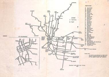
Map, "Tramway and Light Rail System - with substations", 1988
... Also locates depots and the location of the Carlton Centre control centre Not known who prepared the plan....Also locates depots and the location of the Carlton Centre control centre Not known who prepared the plan. ...Map or Plan, titled "Tramway and Light Rail System", showing the routes as in 1988 with substations located and their abbreviation and name. Has an enlargement for the city area. Also locates depots and the location of the Carlton Centre control centre Not known who prepared the plan.trams, tramways, map, substation, depots, power supply, electrical engineering -
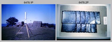 Bendigo Military Museum
Photograph - Royal Australian Survey Corps - Map Production Processes, c1990
... Heidelberg Speedmaster 102 computer-controlled five colour lithographic offset printing press. .17) & .18) – Photo, colour, c1990s. Army Map Depot, unidentified storeman, Bandiana. .19) – Photo, colour, c1990. RASvy ARA Unit Locations...Heidelberg Speedmaster 102 computer-controlled five colour lithographic offset printing press. .17) & .18) – Photo, colour, c1990s. Army Map Depot, unidentified storeman, Bandiana. .19) – Photo, colour, c1990. RASvy ARA Unit Locations ...This is a collection of 20 photographs of Royal Australian Survey Corps phases of map production at the School of Military Survey, Bonegilla, the Army Survey Regiment, Bendigo, and the Army Map Depot, Bandiana circa 1990. Colour photos are on 35mm slide film and were scanned at 96 dpi. They are part of the Army Survey Regiment’s Collection. Photo .1P was probably taken on a survey station overlooking Lake Hume near Albury-Wodonga. The field party occupying the survey station was likely from a Map Control Survey course conducted by the School of Military Survey, Bonegilla. This survey station was part of a geodetic network used in field survey training and RASvy’s Lake Hume Test Range. Photos .3P to .16P were taken at the Army Survey Regiment, Bendigo and photos .17P & .18P were taken at the Army Map Depot, Bandiana. Photo .19P depicts a map of RASvy’s ARA units before the disbandment of 5th Field Survey Squadron, Perth and 2nd Field Survey Squadron, Sydney in 1990. This is a collection of 20 photographs of map production processes taken at the School of Military Survey, Bonegilla, the Army Survey Regiment, Bendigo, and the Army Map Depot, Bandiana circa 1990. Colour photos are on 35mm slide film and were scanned at 96 dpi. They are part of the Army Survey Regiment’s Collection. Photo .2P is printed on photographic and scanned at 300 dpi. .1) – Photo, colour, c1980s. Geodetic Surveying: AN/PRR-14 Geoceiver antenna on hill surrounding Lake Hume. Series 3 Land Rover, field party tent and survey station beacon in background. .2) – Photo, black & white, c1980s. Geodetic Surveying: AN/PRR-14 Geoceiver antennas set up at the School of Military Survey, Bonegilla, Victoria. .3) – Photo, colour, c1990. Aerotriangulation: Wild PUG4 point transfer device, SSGT Bruce Hammond. .4) – Photo, colour, c1990. Aerotriangulation: Zeiss (Jena) Stecometer, SSGT Bruce Hammond. .5) – Photo, colour, c1990. Aerotriangulation: computer tape maintenance, SSGT Noel McNamara. .6) – Photo, colour, c1990. AUTOMAP 2: computer tape maintenance, SPR Nadine (Paul) Read. .7) - Photo, colour, c1990s. AUTOMAP 2: Optronics 4040 scanning/film output in Lithographic Squadron, SGT Sherri (Dally) Burke. .8) - Photo, colour, c1990s. AUTOMAP 2: Benson verification plotter output, SPR Nadine (Paul) Read. .9) – Photo, colour, c1990. Aerotriangulation: data management, SGT Neil ‘Ned’ Kelly. .10) & .11) - Photo, colour, c1990s. AUTOMAP 2: Wild B8 Aviograph stereoplotter Feature Extraction, unidentified technician. .12) - Photo, colour, c1990s. AUTOMAP 2: Graphic Edit Workstation, SPR Nadine (Paul) Read. .13) - Photo, colour, c1990s. AUTOMAP 2: Graphic Edit Workstation, SPR Dawn Hoadley. .14) & .15) - Photo, colour, c1990s. AUTOMAP 2: Graphic Edit Workstation, unidentified technician. .16) – Photo, colour, c1990s. Heidelberg Speedmaster 102 computer-controlled five colour lithographic offset printing press. .17) & .18) – Photo, colour, c1990s. Army Map Depot, unidentified storeman, Bandiana. .19) – Photo, colour, c1990. RASvy ARA Unit Locations before disbandment of field units in Perth and Sydney. .20) – Photo, colour, c1990. Set of overlapping aerial photography..1P, .3P to .20P - Some equipment is identified on the frame of the 35mm slides.royal australian survey corps, rasvy, army survey regiment, army svy regt, fortuna, asr, school of military survey, army map depot -
 Bendigo Military Museum
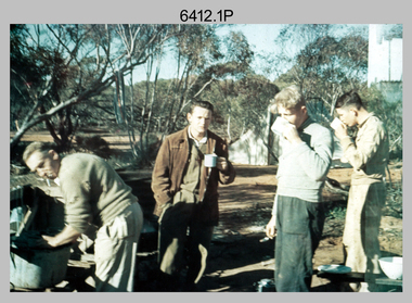
Photograph - Royal Australian Survey Corps Surveyors in the Field – Victoria, 1956 - 1958
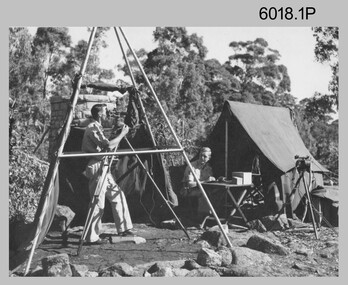
... control. In this era surveyors used theodolites to observe horizontal and vertical angles and chains to measure base line distances between survey stations. Royal Australian Survey Corps RASvy Army Survey Regiment ASR Army Svy Regt Fortuna surveying .1P to .2P annotated on back – personnel names, the year and the location. ...This is a set of two photographs of surveyors and support staff in the field undertaking tasks in Victoria 1956 – 1958. The surveyors were employed in the establishment of mapping and geodetic control. In this era surveyors used theodolites to observe horizontal and vertical angles and chains to measure base line distances between survey stations. This is a set of 23 photographs of surveyors and support staff in the field undertaking duties in Victoria 1956 – 1958. The photographs were printed on photographic paper and are part of the Army Survey Regiment’s Collection. The photographs were scanned at 300 dpi. .1) - Photo, colour, 1956. Surveyors enjoying a tea break. L to R: Tom Gilbert (cook), Barry Broad, Tony Slattery, John Van De Graff. Taken at Boonoonar, a locality south of Mildura. .2) - Photo, colour, 1958. Surveyors taking a break from driving. L to R: Leo Bub, Bob Thompson. Taken at Puckapunyal..1P to .2P annotated on back – personnel names, the year and the location. royal australian survey corps, rasvy, army survey regiment, asr, army svy regt, fortuna, surveying -
 Bendigo Military Museum
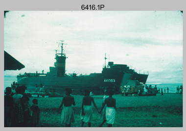
Photograph - Royal Australian Survey Corps Surveyors in the Field – PNG, 1962
... control. In this era surveyors used theodolites to observe horizontal and vertical angles and tellurometers to measure base line distances between survey stations. From 1957 helicopter transport of survey parties revolutionised transport in remote areas. Royal Australian Survey Corps RASvy Army Survey Regiment ASR Army Svy Regt Fortuna surveying .1P to .4P annotated on back – personnel names, the year and the location ...This is a set of four photographs of surveyors and support staff in the field undertaking duties in Dogera, Milne Bay Province and Kerema, Gulf Province of PNG in 1962. The surveyors were employed in the establishment of mapping and geodetic control. In this era surveyors used theodolites to observe horizontal and vertical angles and tellurometers to measure base line distances between survey stations. From 1957 helicopter transport of survey parties revolutionised transport in remote areas.This is a set of four photographs of surveyors and support staff in the field undertaking duties in PNG in 1962. The photographs were printed on photographic paper and are part of the Army Survey Regiment’s Collection. The photographs were scanned at 300 dpi. .1) - Photo, colour, 1962. Unloading survey operation stores from a Landing Ship Medium (LSM) at Dogera, Milne Bay Province, PNG. .2) & .3) - Photo, colour, 1962. Hired civilian helicopter Bell 47G-2 helicopters operating at at Dogera, Milne Bay Province, PNG. .4) - Photo, colour, 1962. Survey party at survey station located near Kerema, Gulf Province southern PNG. L to R: Dave Owens, Keith Broadbent, with local villagers in background..1P to .4P annotated on back – personnel names, the year and the location. royal australian survey corps, rasvy, army survey regiment, asr, army svy regt, fortuna, surveying -
 Bendigo Military Museum
Photograph - Royal Australian Survey Corps Surveyors in the Field, Army Survey Regiment, 1950s to 1970s
... They were probably employed in establishing mapping and geodetic control operations or the surveyors may have been in training. Photo .1P was possibly taken at Mount Alexander in Central Victoria, a location close to Bendigo, as the stone cairn in the background of the photo appears to be identical to the cairn presently located on top of the mountain. ...They were probably employed in establishing mapping and geodetic control operations or the surveyors may have been in training. Photo .1P was possibly taken at Mount Alexander in Central Victoria, a location close to Bendigo, as the stone cairn in the background of the photo appears to be identical to the cairn presently located on top of the mountain. ...These three photographs were most likely taken from the 1950s to the 1970s. The RASvy surveyor in each photograph was taking angular measurements with the observer recording their readings on a booking form. They were probably employed in establishing mapping and geodetic control operations or the surveyors may have been in training. Photo .1P was possibly taken at Mount Alexander in Central Victoria, a location close to Bendigo, as the stone cairn in the background of the photo appears to be identical to the cairn presently located on top of the mountain. Personnel and location have been confirmed on another photo in the collection with annotation. These three photographs are of surveyors in the field undertaking observations using theodolites. The photographs were printed on photographic paper and are part of the Army Survey Regiment’s Collection. The photographs were scanned at 300 dpi. .1) - Photo, black & white, c1950s. Unidentified personnel undertaking observations with a Tavistock geodetic theodolite. .2) – Photo, colour, mounted on card, c1960s. Unidentified personnel undertaking observations with a Kern DKM2 theodolite. .3) - Photo, colour, c1970s. Unidentified personnel undertaking observations with a theodolite..1 – not annotated .2 –annotated on front “Kern DKM2, TOPO 10” royal australian survey corps, rasvy, army survey regiment, army svy regt, fortuna, asr, surveying -
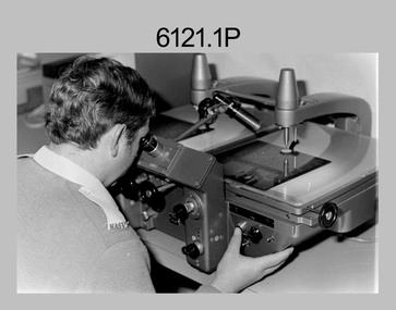
 Bendigo Military Museum
Photograph - Army Survey Regiment Map Production Equipment, c1980s, c1990s
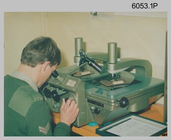
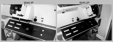
... locations and personnel, they are positively identified. CPL Ian Nelson in photo .1P is operating a Wild Pug 4 point transfer device in Air Survey Squadron c1980s. Control...locations and personnel, they are positively identified. CPL Ian Nelson in photo .1P is operating a Wild Pug 4 point transfer device in Air Survey Squadron c1980s. Control ...Photos .1P, .2P, and.4P were most likely taken in the 1980s and photos .3P, .5P to .8P in the c1990s at the Army Survey Regiment, Fortuna, Bendigo. Despite lacking annotation on exact dates, locations and personnel, they are positively identified. CPL Ian Nelson in photo .1P is operating a Wild Pug 4 point transfer device in Air Survey Squadron c1980s. Control points were transferred onto the mapping diapositives of aerial photography by drilling their locations into the photographic emulsion. SPR Viv (Hawkins) Doherty in photo .2P, SPR Jeanette Drury-Lane in photo .5P and SGT Sandy Craig are operating a Wild B8 Stereoplotter coupled to a digital workstation in Air Survey Squadron c1994. Topographic features were extracted with the B8 in 3D and feature coded with attributes, using keyboard, menu, keypad and voice inputs to the computer. The features were stored in the AUTOMAP 2 digital database for subsequent cartographic production and printing. CPL Mick Ellis in photo .3P is operating the Optronix 4040 Scanner/Film Writer in Lithographic Squadron c1990s. In scanning mode, compilation sheets were mounted on the drum and scanned. The resultant raster file was vectorized, feature coded with attributes and stored by cartographic technicians in the AUTOMAP 2 database. In film writing mode, digital cartographic files were output at very high resolution for each print colour on photosensitive film, for subsequent finalisation, platemaking and printing.This is a set of eight photographs of technicians operating map production equipment at the Army Survey Regiment, Bendigo. The photographs were printed on photographic paper and are part of the Army Survey Regiment’s Collection. The photographs were scanned at 300 dpi. Photo negatives were scanned at 2400 dpi. .1) - Photo, colour, c1980s. CPL Ian Nelson operating a Wild Pug 4 point transfer device in Air Survey Squadron. .2) - Photo, colour, c1980s. Wild B8 Aviograph stereoplotter feature extraction, SPR Viv (Hawkins) Doherty in Air Survey Squadron. .3) - Photo, colour, c1990s. CPL Mick Ellis operating the Optronics 4040 Scanner in Lithographic Squadron. .4) - Photo, colour, c1984. AUTOMAP 2 Graphic Edit Workstation, SPR Craig Kellet in Cartographic Squadron. .5) - Photo, colour, c1994. Wild B8 Aviograph stereoplotter feature extraction, SPR Jeanette Drury-Lane in Air Survey Squadron. .6) - Photo, colour, c1994. AUTOMAP 2 Graphic Edit Workstation, L to R: unidentified, SPR Rachel (Stanford) Scott, CPL Chris Wynn in Cartographic Squadron. .7) - Photo, colour, c1994. Wild B8 Aviograph stereoplotter AUTOMAP 2 Graphic Edit Workstation, L to R: unidentified (x2), SGT Sandy Craig in Air Survey Squadron. .8) - Photo, colour, c1994. AUTOMAP 2 Graphic Edit Workstation, L to R: unidentified, SPR Peter Smyth, SPR Frank Savy, SPR Quentin Seecamp, CPL Steve McGuiness in Cartographic Squadron. .1P – no annotations .2P – annotated “Stereoplotter Workstation. The operator has the use of keyboard, menu, keypad and voice for input to the computer. Feedback is given through voice and screen messages.” .3 to .8P – no annotationsroyal australian survey corps, rasvy, army survey regiment, army svy regt, fortuna, air survey, litho, aerotrig, automap 2 -
 Bendigo Military Museum
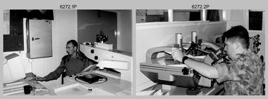
Photograph - Aerotriangulation Production – Army Survey Regiment, Fortuna, Bendigo, c1989
... The Control points were transferred from the control photography to the mapping diapositives of aerial photography by drilling their locations into the photographic emulsion. ...The Control points were transferred from the control photography to the mapping diapositives of aerial photography by drilling their locations into the photographic emulsion. ...This collection of 17 photographs of Air Survey Squadron aerotriangulation equipment and personnel was taken at the Army Survey Regiment, Fortuna, Bendigo, circa 1989. The PDP 11/70 minicomputer was the operating system introduced in 1977 as the mainframe system for the control of the APC4, aerial triangulation block adjustments, SORA OP Analytical Orthophoto control, APR Analytical Terrain Profile Recorder computation, graphics, and general computing. The OMI/Nistri AP/C-3 analytical plotter shown in photo .1P to .6P and .9P was introduced in 1972–1973. The Zeiss (Jena) Stecometer analytic stereocomparator for air photography shown in photo .16P was introduced at Air Survey Squadron in 1963. Aerotriangulation production was expedited using computers for analytical photogrammetric processes. The technician accurately measured between pass, tie, and survey control points on aerial photographs. Wild PUG4 point transfer devices as shown in photo .17P, were introduced in c1968 superseding the PUG2 devices. PUG4 devices were used by technicians to stereoscopically view the photography containing the survey control points and the mapping aerial photography. The Control points were transferred from the control photography to the mapping diapositives of aerial photography by drilling their locations into the photographic emulsion. See item 6195.19P for more photos of aerotriangulation equipment and their operation in map production.This is a set of 17 photographs of Air Survey Squadron aerotriangulation equipment and personnel taken at the Army Survey Regiment at Fortuna, Bendigo, circa 1989. The photographs are on 35mm negative film and scanned at 96 dpi. They are part of the Army Survey Regiment’s Collection. .1) to .7) - Photo, black & white, c1989, OMI/Nistri APC/3-1 analytical stereoplotter. .8) - Photo, black & white, c1989, miscellaneous aerotriangulation equipment. .9) to.10) - Photo, black & white, c1989, Digital Equipment Corporation (DEC) 11 VO3-L Superminicomputer, with VT52 DECScope terminal. .11) to .15) - Photo, black & white, c1989, miscellaneous aerotriangulation equipment. .16) - Photo, colour, c1989, Zeiss (Jena) Stecometer, unidentified technician. .17) - Photo, black & white, c1989, Wild PUG4 point transfer device, unidentified technician..1P to .17P – There are no annotationsroyal australian survey corps, rasvy, fortuna, army survey regiment, air survey, aerotrig -
 Kiewa Valley Historical Society
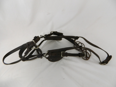
Bridle Horse, circa mid to late 1900's
... control. It is only in the later 1900's that motor bikes and four wheeled quad-bikes have taken over, in part, from the mounted stockman. This horse bridle is very significant to the Kiewa Valley because of the early introduction of cattle and sheep stations in what initially was regarded as a semi remote valley location. ...This stock horse bridle was probably used in the mid 1900's. This was the period when cattle and sheep mustering was at its prime. The movement of cattle and sheep was by mounted stock horse only and not by other methods. Northern territory cattle stations in the late 1900's started to use helicopters for "cattle control". In the KIEWA Valley/Bogong High Plains and other rural cattle/sheep producing areas required well trained stock horses and stockmen for cattle/sheep control. It is only in the later 1900's that motor bikes and four wheeled quad-bikes have taken over, in part, from the mounted stockman.This horse bridle is very significant to the Kiewa Valley because of the early introduction of cattle and sheep stations in what initially was regarded as a semi remote valley location. The maintenance of cattle and sheep in the Kiewa Valley was, and still is an important requirement of livestock management. A good stock horse bridle is important, especially during the period when cattle and sheep were grazed on the Bogong High Plains. The mustering and and moving cattle/sheep from the valley pastures to the high country was a demanding and dangerous exercise requiring "sure footed" stock horses.The "good specialised" bridle was a vital part of this cattle/sheep mustering. A scientific study started in 1947 to study the impact of grazing cattle/sheep on the natural Alpine and sub Alpine vegetation found grazing cattle had an adverse affect on the natural Alpine and sub alpine vegetation, and grazing on the plains was stopped by the Victorian Government in 2005.This "camp draft" on the Bogong High Plains could take up to six weeks.This harness bridle includes "blinders, winklers or blinkers" and would therefore be used on a pack or "working" horse. This bridle has rings on each end of the browband. The bridle is one used by a horse working in a team configuration pulling a heavy cart or wagon. The bridle has ten adjustable straps to allow it to accommodate a variety of horse sizes. See KVHS 0495 for a stock horse saddle.horse, country, leather bridle, gaiters, high country grazing, cattlemen, laces, studs -
 Kiewa Valley Historical Society
Pie Iron Camping, circa mid to late 1900s
... As the control of cattle and sheep in the High Plains was very demanding upon horse and rider, good "tucker" was a pre- requisite for a successful operation. As the time spent in this remote location ...This Pie Iron was used in the mid to late 1900's when stock, both cattle and sheep, were grazed on the Bogong High Plains. Providing meals for stockmen over open fires, even in log cabins in the Victorian Alpine region, was usually by a "camp cook" or a stockman designated "cook" from the Valley station/property. The use of "camping cooking utensils were a necessity and not a "weekend" affair. Stockmen could spend up to six weeks on the plains and all their cooking needs required had to "pack horsed" from the valley below. A scientific study started in 1947, to study the impact of grazing cattle on the natural Alpine and sub Alpine vegetation found grazing cattle had an adverse affect on the natural Alpine and sub alpine vegetation, and grazing on the plains was stopped by the Victorian Government in 2005.This item is highly significant to the Kiewa Valley as it demonstrates the kind of cooking utensils that were required for camp drafts in the Bogong High Plains environment. As the control of cattle and sheep in the High Plains was very demanding upon horse and rider, good "tucker" was a pre- requisite for a successful operation. As the time spent in this remote location was governed by the climatic condition maximum utilisation of the very good pastures in the High Plains was crucial to a successful and profitable season.This pie iron has two pie forms in horizontal configuration and both top and base rounded forms are connected at one end (Top) with pop rivet application. This application allows for the "opening" up of the two halves. The bodies are made from cast iron in a "cup" form and a metal rod and wooden handle extend to permit the opening of the two sides. The inner side of the "cups" are smooth which relates to pie requirements and not the jaffle/sandwich irons. A clasp metal "D" ring is installed at the end of one wooden handle (to keep the iron in the close/cooking position).camp fire cooking utensils, hot plate, cast iron cooking appliances, pie irons, jaffle irons, drovers kitchen -
 Bendigo Military Museum
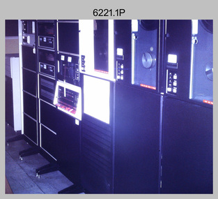
Photograph - Aerotriangulation Production – Army Survey Regiment, Fortuna, Bendigo, c1979
... The Control points were transferred from the control photography to the mapping diapositives of aerial photography by drilling their locations into the photographic emulsion.See item 9045.17P for more photos of aerotriangulation equipment and their operation in map production....The Control points were transferred from the control photography to the mapping diapositives of aerial photography by drilling their locations into the photographic emulsion.See item 9045.17P for more photos of aerotriangulation equipment and their operation in map production. ...This collection of 19 photos was most likely taken in 1979 in Air Survey Squadron. The PDP 11/70 minicomputer shown in photos .2P to .3P was the operating system introduced in 1977 as the mainframe system for the control of the APC4, aerial triangulation block adjustments, SORA OP Analytical Orthophoto control, APR Analytical Terrain Profile Recorder computation, graphics, and general computing. The Zeiss (Jena) Stecometer analytic stereocomparator for air photography shown in photos .5P to .9P was introduced at Air Survey Squadron in 1963. Aerotriangulation production was expedited using computers for analytical photogrammetric processes. The technician accurately measured between pass, tie, and survey control points on aerial photographs. The OMI/Nistri AP/C-3 analytical plotter shown in photos .10P and .11P was introduced in 1972–1973. Photo .11P shows a coordinatorgraph attached to the AP/C-3. The Zeiss D2 Planimat Stereoplotter shown in photo .12P was used for analytical orthophoto control. Wild PUG4 point transfer devices shown in photos .17P to .19P were introduced in c1968 superseding the PUG2 devices. PUG4 devices were used by technicians to stereoscopically view the photography containing the survey control points and the mapping aerial photography. The Control points were transferred from the control photography to the mapping diapositives of aerial photography by drilling their locations into the photographic emulsion.See item 9045.17P for more photos of aerotriangulation equipment and their operation in map production.This is a set of 19 photographs of Air Survey Squadron personnel operating aerotriangulation equipment at the Army Survey Regiment at Fortuna, Bendigo, c1979. Black and white photos are on photographic paper and were scanned at 300 dpi. They are part of the Army Survey Regiment’s Collection. .1) - Photo, black & white, c1979, Aerotriangulation tasks, unidentified technicians. .2) to .3) - Photo, black & white, c1979, PDP-11 minicomputers tasks, unidentified technician. .4) - Photo, black & white, c1979, Aerotriangulation tasks, unidentified technician. .5) - Photo, colour, c1979, Zeiss (Jena) Stecometer, unidentified technician. .6) to.9) - Photo, black & white, c1979, Zeiss (Jena) Stecometer, unidentified technician. .10) - Photo, black & white, c1984, OMI/Nistri APC/3-1 analytical stereoplotter, SPR Kristin (Isaac) Skidmore. .11) - Photo, colour, c1979, OMI/Nistri APC/3-1 analytical stereoplotter, unidentified technician. .12) - Photo, colour, c1979, Zeiss D2 Planimat Stereoplotter, unidentified technician. .13) - Photo, black & white, c1979, Aerotriangulation tasks, unidentified technician. .14) - Photo, black & white, c1979, Aerotriangulation tasks, unidentified technician. .15) - Photo, black & white, c1979, Aerotriangulation tasks, CPL Ken Talbot-Smith .16) - Photo, black & white, c1979, Aerotriangulation tasks, SPR David Jobe. .17) - Photo, black & white, c1979, Wild PUG4 point transfer device, WO2 Brian Mead. .18) - Photo, black & white, c1979, Wild PUG4 point transfer device, CPL Andy Wilson. .19) - Photo, black & white, c1979, Wild PUG4 point transfer device, unidentified technician..5P is annotated ‘OMI-Nistri AP/C Analytical Plotter’ and ’Topo 36’. .12P is annotated ‘Zeiss Jena Stecometer Stereocomparator’ and ’Topo 35’. There are no annotations on the other photos.royal australian survey corps, rasvy, army survey regiment, army svy regt, fortuna, asr, aerotrig, air survey -
 Bendigo Military Museum
Photograph - Aerotriangulation Production – Army Survey Regiment, Fortuna, Bendigo, c1993
... The Control points were transferred from the control photography to the mapping diapositives of aerial photography by drilling their locations into the photographic emulsion. ...The Control points were transferred from the control photography to the mapping diapositives of aerial photography by drilling their locations into the photographic emulsion. ...This is a collection of eight photographs of Air Survey Squadron personnel operating aerotriangulation equipment at the Army Survey Regiment at Fortuna, Bendigo, c1993. PUG4 devices were used by technicians to stereoscopically view the photography containing the survey control points and the mapping aerial photography. The Control points were transferred from the control photography to the mapping diapositives of aerial photography by drilling their locations into the photographic emulsion. The Zeiss (Jena) Stecometer analytic stereocomparator for air photography shown in photo .1P was introduced at Air Survey Squadron in 1963. Wild PUG4 point transfer devices shown in photos .2P to .4P were introduced in c1968 superseding the PUG2 devices. See item 6195.19P for more photos and descriptions of Air Survey Squadron personnel and aerotriangulation equipment.This is a set of eight photographs of Air Survey Squadron personnel operating aerotriangulation equipment at the Army Survey Regiment at Fortuna, Bendigo, c1993. The photographs were on 35mm negative film and were scanned at 96 dpi. They are part of the Army Survey Regiment’s Collection. .1) - Photo, black & white, c1993, Zeiss (Jena) Stecometer, SPR Kim Baker. .2) - Photo, black & white, c1993, Wild PUG4 point transfer device, CPL Paul Bouton. .3) to .4) - Photo, black & white, c1993, Wild PUG4 point transfer device, L to R: CPL Darren Scott, CPL Paul Bouton. .5) to .6P) - Photo, black & white, c1993, CPL Doug Willis. .7) - Photo, black & white, c1993, WO2 Noel ‘Macca’ McNamara. .8) - Photo, black & white, c1993, SGT Barry Miller..1P to .8P - There are no annotations.royal australian survey corps, rasvy, army survey regiment, army svy regt, fortuna, asr, aerotrig -
 Bendigo Military Museum
Photograph - Aerotriangulation Production – Army Survey Regiment, Fortuna, Bendigo, c1970s to 1980s
... The Control points were transferred from the control photography to the mapping diapositives of aerial photography by drilling their locations into the photographic emulsion....The Control points were transferred from the control photography to the mapping diapositives of aerial photography by drilling their locations into the photographic emulsion. ...This collection of 14 photos was most likely taken in the 1970s and 1980s in Air Survey Squadron. The PDP 11/70 minicomputer shown in photo .1P was the operating system introduced in 1977 as the mainframe system for the control of the APC4, aerial triangulation block adjustments, SORA OP Analytical Orthophoto control, APR Analytical Terrain Profile Recorder computation, graphics, and general computing. Technicians used the Wild A9 Stereocomparator shown in photo .2P to accurately measure between pass, tie, and survey control points on aerial photographs. The Zeiss D2 Planimat Stereoplotter shown in photos .3P to .4P was used for analytical orthophoto control. It was introduced in 1972-1973 The Zeiss (Jena) Stecometer analytic stereocomparator for air photography shown in photos .5P to .11P and .14P was introduced at Air Survey Squadron in 1963. Aerotriangulation production was expedited using computers for analytical photogrammetric processes. The technician accurately measured between pass, tie, and survey control points on aerial photographs. Wild PUG4 point transfer devices shown in photos .12P to .13P were introduced in c1968 superseding the PUG2 devices. PUG4 devices were used by technicians to stereoscopically view the photography containing the survey control points and the mapping aerial photography. The Control points were transferred from the control photography to the mapping diapositives of aerial photography by drilling their locations into the photographic emulsion.This is a set of 14 photographs of Air Survey Squadron personnel operating aerotriangulation equipment at the Army Survey Regiment at Fortuna, Bendigo, c1970s to 1980s. Photographs .1P to .13P were on 35mm colour slide film and scanned at 96 dpi. Photograph.14P was printed on photographic paper and was scanned at 300 dpi. They are part of the Army Survey Regiment’s Collection. .1) - Photo, colour, c1979, PDP-11 minicomputer. .2) - Photo, colour, c1970s, Unidentified technician operating a Wild A9 Stereocomparator. .3) - Photo, colour, c1970s, Zeiss D2 Planimat Stereoplotter. .4) - Photo, colour, c1970s, Zeiss D2 Planimat Stereoplotter, unidentified technicians. .5) - Photo, colour, c1970s, Zeiss D2 Planimat Stereoplotter, SGT Christopher Wardley. .6) - Photo, colour, c1970s, Zeiss D2 Planimat Stereoplotter. .7) to.9) - Photo, colour, c1970, Zeiss (Jena) Stecometer, unidentified technicians. .10) to.11) - Photo, colour, c1988, SPR Toni Wright operating a Zeiss (Jena) Stecometer. .12) - Photo, colour, c1970s, Wild PUG4 point transfer device, SPR John Shepard. .13) - Photo, colour, c1970s, Wild PUG4 point transfer device, SPR David Edwards. .13) - Photo, colour, c1970s, Wild PUG4 point transfer device, SPR David Edwards. .14) - Photo, colour, c1980, Zeiss (Jena) Stecometer, SGT Bruce Hammond.Some of the equipment is annotated on the frame of the 35mm slides.royal australian survey corps, rasvy, army survey regiment, army svy regt, fortuna, asr, aerotrig, photogrammetry -
 Bendigo Military Museum
photograph - Fortuna - 1st Year of Army Occupation in Bendigo, 1942
... The location of HQ 5th Army Troop was ‘Reynard St, Coburg.’ By late 1941 as Japan extended its control throughout Indo-China, resolving the accommodation problem of AHQ Cartographic Company located in Melbourne became more urgent. ...The location of HQ 5th Army Troop was ‘Reynard St, Coburg.’ By late 1941 as Japan extended its control throughout Indo-China, resolving the accommodation problem of AHQ Cartographic Company located in Melbourne became more urgent. ...This is a set of 17 photographs taken during the first year of Army occupation at Fortuna, Bendigo in 1942. The photos provide an insight into the preparatory work performed on the Fortuna Villa and surrounding buildings, by the Working Party 5th Army Troop and Ordnance Training Depot, before its occupation by personnel from LHQ Cartographic Company, Royal Australian Survey Corps. The annotation on the back of Photos .9P and .10P is misspelt. The correct spelling is ‘Nell Gwynne’. The poppet head of the Central Nell Gwynne mine is still an iconic landmark in Bendigo, lying just down the road from the poppet head lookout at Victoria Hill. The Central Nell Gwynne was the premier mine of Bendigo's 1930s mining revival and is of high historical value, due to the extensive and relatively intact features which remain at the site. The annotation on the back of Photo .17P is incorrect. The location of HQ 5th Army Troop was ‘Reynard St, Coburg.’ By late 1941 as Japan extended its control throughout Indo-China, resolving the accommodation problem of AHQ Cartographic Company located in Melbourne became more urgent. The steady Japanese advance made the bombing of Melbourne no longer a remote possibility, and in accordance with a general policy of dispersion, the Deputy Chief of the General Staff, Major General Sidney Rowell instructed Major William Sarll, in the interests of security of plant and to provide against possible damage of air attack, to investigate suitable safer inland accommodation for AHQ Cartographic Company. Major Sarll inspected many properties before finding one that would meet the requirements of the Cartographic Company. In late 1941, he came to inspect Fortuna, a rambling old mansion with about fifteen acres of ground in central Bendigo. Initially there was no intention to occupy the site beyond the end of the war, although Major Sarll's report to the Director of Survey noted many advantages in moving the Company to Bendigo. Major General Rowell quickly approved the selection of Fortuna before other authorities, which were investigating the evacuation of school children, could get in ahead of the Cartographic Company. On 23 March 1942, the Commonwealth of Australia, under the provisions of the National Security Act of 1939, took possession of the house, the old battery buildings and the fifteen acres of grounds. Under Warrant Officer J. Trist’s direction, over fifty Parks and Works tradesmen completed building works necessary to accommodate the Survey Corps’ military, map making and printing requirements. The building program was still under way when the first officer, Lieutenant Ralph Westgarth, arrived in May 1942 with the advance party which received and positioned all equipment as it came up from Melbourne in semi-trailers. Once the equipment was installed the rest of the Cartographic Company completed its shift to Bendigo by 11th June 1942. The first year of the Survey Corps’ occupation of Fortuna is covered in more detail with additional historic photographs, in pages 17-22 of Valerie Lovejoy’s book 'Mapmakers of Fortuna – A history of the Army Survey Regiment’ ISBN: 0-646-42120-4.This is a set of 17 photographs taken during the first year of Army Occupation at Fortuna, Bendigo in 1942. The black and white photographs were printed on photographic paper and are part of the Army Survey Regiment’s Collection. The photographs were scanned at 300 dpi. .1) - Photo, black & white, 1942. Bendigo Parks and Works tradesmen at Fortuna. L to R: Cliff Day, Ernie Arnold, Norm? .2) - Photo, black & white, 1942. “Don” - possibly SGT Don Sutcliffe. Fortuna, Bendigo. .3) - Photo, black & white, 1942. Parks and Works tradesmen in garden at Fortuna, Bendigo. L to R: Fred & Ernie. .4) - Photo, black & white, 1942. Benny Jack Williams at Fortuna, Bendigo. Accommodation tents were erected above the lake, which later became the parade ground. .5) - Photo, black & white, 1942. Working dress - Giggle suits. Parks and Works tradesmen at Fortuna, Bendigo. L to R: Cliff and Harry on big roof. .6) - Photo, black & white, 1942. Parks and Works tradesmen at Fortuna, Bendigo. Ted on big roof. .7) - Photo, black & white, 1942. Gold crusher battery just behind Fortuna. .8) - Photo, black & white, 1942. Scene of Bendigo from Fortuna. .9) - Photo, black & white, 1942. Nell Gwynne Mine from mullock heap at Victoria Hill near Fortuna, Bendigo. .10) - Photo, black & white, 1942. Nell Gwynne Mine and crusher near Fortuna, Bendigo. .11) - Photo, black & white, 1942. Sluicing for gold at Eaglehawk. .12) - Photo, black & white, 1942. Fortuna, Bendigo taken from the far side of tennis courts. .13) - Photo, black & white, 1942. Fortuna, Bendigo & its reflection from across the lake. .14) - Photo, black & white, 1942. Fortuna, Bendigo from the fishpond. .15) - Photo, black & white, 1942. Fortuna, Bendigo. .16) - Photo, black & white, 1942. First Fortuna Football Team at unknown location. L to R: 5th Bob Wright, 11th SGT Don Sutcliffe. .17) - Photo, black & white, 1942. Working Party from 5th Army Troop and Ordnance Training Depot at Fortuna, Bendigo.Some personnel are identified. Annotated with date within photos. .1) – Annotated on back ‘Cliff, Ernie, Norm, Dec ‘42. Cliff Day - dairy farmer, plasterers’ labourer. Ernie Arnold – hard plasterer. Norm? - QM Store for tools etc. QM Store was the Stables.’ .2) - Annotated on back ‘Don. Fortuna 1942’ .3) - Annotated on back ‘Fred & Ernie. Dec 1942. Carpenters. Note the state of the gardens.’ .4) - Annotated on back ‘Benny Jack Williams Fortuna Bendigo. Tents were erected where present day parade ground is above the lake.’ .5) - Annotated on back ‘Working dress - Giggle suits. June 42. Cliff and Harry on big roof. This photo was taken as the ventilating ridge was being installed on the building housing the printing machines. The machines were installed later by civilian labour when building was complete.’ .6) - Annotated on back ‘Ted on big roof Fortuna Bendigo.’ .7) - Annotated on back ‘Gold crusher battery – Bendigo for slay heap – 1942. 12 stamp battery. Just behind Fortuna. Was working at night when the “Army” came to Bendigo. Later removed to “Coolgardie - WA. Present site of Southern Cross TV.’ .8) - Annotated on back ‘Scene of Bendigo from Fortuna. June 1942.’ .9) - Annotated on back ‘Nell Gwyne Mine from mullock heap (Victoria Hill) Sept 1942.’ .10) - Annotated on back ‘Nell Gwyne Mine and crusher September 1942.’ .11) - Annotated on back ‘Sluicing for gold at Eaglehawk. August 1942.’ .12) - Annotated on back ‘Fortuna Bendigo 1942. Taken from far side of tennis courts.’ .13) - Annotated on back ‘ “Fortuna” across the lake & reflection.’ .14) - Annotated on back ‘Fortuna from fishpond June 1942.’ .15) - Annotated on back ‘Fortuna Dec 1942.’ .16) - Annotated on front ‘X’ x2. Annotated on back First Fortuna Football Team 1942‘Bob Wright’, ‘SGT Don Sutcliffe’. .17) - Annotated ‘Working Party at Fortuna before one of the drafts’, Working Party 5th Army Troop and Ordnance Training Depot Showgrounds, now the Sportsground Bendigo’, ‘HQ of 5th Army Troop was Reynards Rd, Coburg.’royal australian survey corps, rasvy, army survey regiment, army svy regt, fortuna, asr -
 Bendigo Military Museum
photograph - Aerotriangulation Production – Army Survey Regiment, Fortuna, Bendigo, c1980
... The Control points were transferred from the control photography to the mapping diapositives of aerial photography by drilling their locations into the photographic emulsion. ...The Control points were transferred from the control photography to the mapping diapositives of aerial photography by drilling their locations into the photographic emulsion. ...This collection of five photos was most likely taken in 1980. Wild PUG4 point transfer devices were used by technicians in Air Survey Squadron to stereoscopically view the photography containing the survey control points and the mapping aerial photography. The Control points were transferred from the control photography to the mapping diapositives of aerial photography by drilling their locations into the photographic emulsion. The Zeiss (Jena) Stecometer analytic stereocomparator for air photography was introduced at Air Survey Squadron in 1963. Aerotriangulation production was expedited using computers for analytical photogrammetric processes. The technician accurately measured between pass, tie, and survey control points on aerial photographs.Air Survey Squadron Aerotriangulation Section - Army Survey Regiment, Bendigo. c1980. This is a set of five photographs of Air Survey Squadron personnel operating aerotriangulation equipment at the Army Survey Regiment at Fortuna, Bendigo, c1980. Photographs .1P to .4P are on 35mm negative film and were scanned at 96 dpi. Black and white photo .5P is on photographic paper and was scanned at 300 dpi. They are part of the Army Survey Regiment’s Collection. .1) - Photo, black & white, c1980, Wild PUG4 point transfer device, unidentified technician. .2) - Photo, black & white, c1980, Wild PUG4 point transfer device, unidentified technician. .3) - Photo, black & white, c1980, Wild PUG4 point transfer device, unidentified technician. .4) - Photo, black & white, c1980, Zeiss (Jena) Stecometer, unidentified technician. .5) - Photo, black & white, c1980, Zeiss (Jena) Stecometer..1P to .5P No personnel are identified.royal australian survey corps, rasvy, army survey regiment, army svy regt, fortuna, asr, air survey, aerotrig -
 Kiewa Valley Historical Society
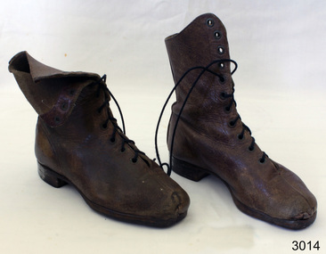
Boots Riding Women's, Circa 1950's
... location (Victorian Alps region). The owner of these boots was Clare Roper, part of the Roper Family who built a "lodging" hut on the "High Plains" for accommodating riders during the periods (up to six weeks) when controlling grazing cattle during the summer muster seasons. ...This pair of "adjustable" boots came from the 1950's era in which the majority of footwear was either locally manufactured or imported from England or Europe. Quality hard wearing leather was a rural necessity especially for the cattle mustering activity in the Kiewa Valley and the Bogong High Plains region. The late 1900's provided a cheaper made riding boot from Asia, however many rural based riders still prefer an Australian made boot. The better quality (stronger stitching) of Australian boots is the main considerations of "stock horse riders". In 1947 a scientific research project started to provide an impact analysis of any damage to alpine vegetation by cattle grazing in the Alpine regions incorporating the Bogong High Plains area. This monitoring is the longest running ecological study ever undertaken in Australia. From this study, compelling evidence was presented to the Victorian Government to cease cattle grazing in the Alpine regions including the Bogong High Plains. All grazing was banned by the Victorian Government in 2005. Recreational horse riding within the Bogong High Plains is still permitted.These pair of women's riding boots are very significant to the Kiewa Valley as the boots were worn by one of the descendants of a pioneer family living and operating a cattle station before the SEC Hydro Electricity Scheme opened up the semi remote rural location in the 1950's. These boots were worn during the annual six weeks (approx.) mustering of cattle in the Bogong High Plains location (Victorian Alps region). The owner of these boots was Clare Roper, part of the Roper Family who built a "lodging" hut on the "High Plains" for accommodating riders during the periods (up to six weeks) when controlling grazing cattle during the summer muster seasons. It was unusual for women in the early to mid 1900's to go up on the High Plains to join the muster, which Clare Roper often did. These boots have high historical significance and good interpretive capacity.These brown "knee high" lady riding boots, are fastened by long "boot" laces which go from the base of the "fastening" position to a boot height of 22 cm. At the top end of the boot is a leather flap which crosses the front section of the boot and is fastened to the outside leg region by two straps. These provide the wearer with an adjustable tie. The boot has a "tongue" of 22 mm long. The boot has six pairs of metal boot lace "hooks" and eight pairs of boot lace "eyelets".ladies riding boots. cattle mustering footwear. rural footwear. cattlemen. bogong high plains. roper family. horses. -
 Kiewa Valley Historical Society
Saddle Horse Stock, Circa 1950
... control. It is only in the later 1900's that motor bikes and four wheeled quad-bikes have taken over, in part, from the mounted stockman. This horse saddle is very significant to the Kiewa Valley because of the early introduction of cattle stations in what initially was regarded as a semi remote location. ...This stock horse saddle was probably used in the mid 1900's. This was the period when cattle mustering was at its prime. The movement of cattle was by mounted stock horse only and not by other methods. Northern territory cattle stations in the late 1900's started to use helicopters for "cattle control". In the KIEWA Valley/Bogong High Plains and other rural cattle producing areas required well trained stock horses and stockmen for cattle control. It is only in the later 1900's that motor bikes and four wheeled quad-bikes have taken over, in part, from the mounted stockman.This horse saddle is very significant to the Kiewa Valley because of the early introduction of cattle stations in what initially was regarded as a semi remote location. The maintenance of cattle in the Kiewa Valley is and was an important requirement. A good stock horse saddle as and is important, especially during the period when cattle were grazed on the Bogong High Plains. The mustering and and moving cattle from the valley pastures to the high country was a demanding and dangerous exercise requiring "sure footed" stock horses.The "good" saddle was a vital part of this cattle mustering. A scientific study started in 1947 to study the impact of grazing cattle on the natural Alpine and sub Alpine vegetation found grazing cattle had an adverse affect on the natural Alpine and sub alpine vegetation, and grazing on the plains was stopped by the Victorian Government in 2005.This "camp draft" in the High Plains could take up to six weeks.This all leather "stock horse" saddle shows plenty of wear. It is in "full harness" configaration with stirrups and leg protectors horse, country, leather, gaiters, high, grazing, cattlemen, laces, studs -
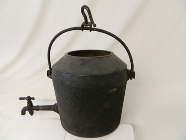 Kiewa Valley Historical Society
Pot Large with Tap, Circa 1950
... control the water flow. The tap suggests that only water was heated (to a constant boil) for the replenishment of cattlemen's, or other horse rider's, tea or coffee mugs. Refreshments at a "temporary" location...control the water flow. The tap suggests that only water was heated (to a constant boil) for the replenishment of cattlemen's, or other horse rider's, tea or coffee mugs. Refreshments at a "temporary" location ...This type of cast iron kettle was used by pioneer families, mainly rural in the early 1900's upon open fires (log). It covered rural activities that needed a constant readily available source of boiling water, in or mainly outside the kitchen of homesteads. This kettle was used in the early to late 1900's for the refreshment of stock men and farmers that had irregular "tea" breaks under sometimes hard and gruelling conditions.This kettle belonged to and was used by a Kiewa Valley, pioneer family, the Roper Family. This kettle was moved from their Kiewa Valley property to their hut built on the Bogong High Plains. The Bogong High Plains area provided Kiewa Valley cattlemen a good supply of fodder to supplement their Kiewa Valley grazing areas. This "camp draft" activity , in the high plains, could take up to six weeks.This large cast iron modified camp pot (cauldron) has a long tap connection located at the bottom end. The "tap" is made from brass and has a simple elongated "bar" control swivel at the end to control the water flow. The tap suggests that only water was heated (to a constant boil) for the replenishment of cattlemen's, or other horse rider's, tea or coffee mugs. Refreshments at a "temporary" location on the Bogong High Plains. There was a "log" hut built by the Roper family as temporary accommodation for cattlemen and other family members.Ot the flat bottom "FIRST QUALITY 2 GALLONS"camp fire cooking utensils, hot plate, cast iron cooking appliance, drovers kitchen -
 Kiewa Valley Historical Society
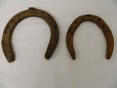
Shoes Horse Stock and Draft, early 1900's
... control". These horse shoes are very significant to the Kiewa Valley because of the early introduction of cattle stations in what initially was regarded as a semi remote location. ...These horse shoes (one a stock horse and one a draft horse) were probably used in the mid 1900's. They have been roughly made suggesting that a professional blacksmith was not instrumental in their manufacture. On smaller or remote cattle stations either the lead stock man or owner would "fire up" the kiln to provide the adjustments required to the horse shoe to ensure a "tight" fit. The larger cattle stations had a "professional" blacksmith to cover all their "working" horses. Larger properties eg.large Northern territory cattle stations use helicopters for "cattle control".These horse shoes are very significant to the Kiewa Valley because of the early introduction of cattle stations in what initially was regarded as a semi remote location. The maintenance of horses hooves is an important requirement, especially during the period when cattle were grazed on the Bogong High Plains. The mustering and and moving cattle from the valley pastures to the high country was a demanding and dangerous exercise requiring "sure footed" stock horses. A scientific study started in 1947 to study the impact of grazing cattle on the natural Alpine and sub Alpine vegetation found grazing cattle had an adverse affect on the natural Alpine and sub alpine vegetation, and grazing on the plains was stopped by the Victorian Government in 2005.This "camp draft" in the High Plains could take up to six weeks.Both these horse shoes have been "roughly" made but are specifically made for the type of horse which wore them. The smaller of the two is for the stock horse/riding horse and the lager one is for the larger draft horse. Each horse type has a specific role to play in the the type of activity it was used for. The small horse shoe has six "nail" holes for attachment to the horse hoof by special nails. The larger shoe has seven "nail" holes. Both have the three quarter moon shape which fits the curvature of the horses hooves. working horses, bogong high plains camp draft, grazing cattle bogong high plains -
 Bendigo Military Museum
Photograph - 4th Field Survey Squadron – Operation NERVOSE 85 Reconnaissance, Northern Territory, 1985
... locations in regions of the Northern Territory. Later that year, Operation NERVOSE 85 was mounted by 4 Fd Svy Sqn in the EAST ARNHEM, VICTORIA RIVER DOWNS AND DALY WATERS areas of the Northern Territory from 26 May to 18 Sep 85. The aim of Operation NERVOSE 85 was to finalise the horizontal and vertical control...locations in regions of the Northern Territory. Later that year, Operation NERVOSE 85 was mounted by 4 Fd Svy Sqn in the EAST ARNHEM, VICTORIA RIVER DOWNS AND DALY WATERS areas of the Northern Territory from 26 May to 18 Sep 85. The aim of Operation NERVOSE 85 was to finalise the horizontal and vertical control ...This is a set of 13 photographs taken in 1985* during reconnaissance of locations in regions of the Northern Territory. Later that year, Operation NERVOSE 85 was mounted by 4 Fd Svy Sqn in the EAST ARNHEM, VICTORIA RIVER DOWNS AND DALY WATERS areas of the Northern Territory from 26 May to 18 Sep 85. The aim of Operation NERVOSE 85 was to finalise the horizontal and vertical control for mapping at a scale of 1:50,000, to field check 40x 1:50,000 preliminary maps and to obtain mapping photography in support of the RAAF TINDAL redevelopment project. *Note –These photos were most likely taken in 1985, contrary to the ‘1987’ date annotated on the negative sleeves. The Op NERVOSE 85 Project Report available on RASVY’s web site lists a nominal roll of personnel. Photos of 4 Fd Svy Sqn taken in 1985 and 1987 provide names of posted personnel. Several personnel identified in these photos were posted to 4 Fd Svy Sqn in 1985, not in 1987.This is a set of 13 photographs taken during 4th Field Survey Squadron’s reconnaissance of Operation NERVOSE 85 locations in the Northern Territory in 1985. The colour photographs are on 35mm negative film and are part of the Army Survey Regiment’s Collection. The photographs were scanned at 96 dpi. .1) to .4) - Photo, colour, 1985. Unknown location in the Northern Territory. .5) - Photo, colour, 1985. Unidentified personnel in the back of a police vehicle. .6P to .12) - Photo, colour, 1985. Unknown location in the Northern Territory. .13) - Photo, colour, 1985. L to R: Possibly MAJ A. Vickers RE - UK Exchange Officer from Army Svy Regt, unidentified officer. .1P to .13P – There are no personnel identified. ‘1987 OP NERVOSE – RECON PHOTOG.’ annotated on negative sleeve.royal australian survey corps, rasvy, 4 fd svy sqn, op nervose 85 -
4th/19th Prince of Wales's Light Horse Regiment Unit History Room
Order of Ceremony, The Royal Australian Amored (sic) Corps the Keeffe Family & Eoghan McDonald Celebrates (sic) the Unveiling of a Commemorative Plaque 16 November 2014, 2014
... control, suddenly the bank on the left collapsed to the extent of 3ft by 12ft by15ft long causing the vehicle to slide into the creek and turn upside down." Captain Pearson and Sergeant Ball were faced with a nightmarish situation: The Grant had come to rest upside down in soft mud, six crew members were unaccounted for, escape hatches could not be opened and the weight of the tank was settling deeper into the water and mud. Compounding the problem was that the location...control, suddenly the bank on the left collapsed to the extent of 3ft by 12ft by15ft long causing the vehicle to slide into the creek and turn upside down." Captain Pearson and Sergeant Ball were faced with a nightmarish situation: The Grant had come to rest upside down in soft mud, six crew members were unaccounted for, escape hatches could not be opened and the weight of the tank was settling deeper into the water and mud. Compounding the problem was that the location ...The 13th Australian Armoured Regiment was a Gippsland militia unit that had been called up for full time duty in December 1941 as a traditional light horse regiment. The early months of 1942 had seen the regiment lose its horses, a conversion to a motor regiment and finally to an armoured regiment in May. During this period there were considerable changes in personnel, however the regiment maintained its strong links to Gippsland and its former identity. Between May and November 1942, individual soldiers had become proficient in their trade training and the regiment changed its focus to troop and squadron activities. On 16 November 1942, the unit was located at the Puckapunyal Army Camp. C Squadron's training program involved a night driving exercise where a column of armoured and B vehicles would depart camp at 0245 hours and proceed to a site to the East of Seymour and set up a bivouac between Whiteheads Creek and Highlands Road. Numerous army camps surrounded the Seymour area; and much of the surrounding farm land had been acquired for military purposes. By November 1942 exercises such as C Squadron's were commonplace and had been repeated on numerous occasions since 1939. At 0400 hrs, C Squadron's vehicles reached O'Sullivan's Paddock on the Kobyboyn Road; prior to reaching the Old Telegraph Road the column turned to the North towards a known crossing point on Whiteheads Creek. The column consisted of seven M3 Medium Tanks and four Universal Carriers. In the case of Corporal McLeod's vehicle, there were seven crewmen rather than the usual five man crew. On arrival at the creek crossing, Captain C.M.I. 'Sandy' Pearson dismounted and with the assistance of Sergeant R.J. Ball began to guide individual tanks across the creek. Four tanks had crossed the creek without difficulty when Corporal McLeod's tank, ARN 24652, began its descent. Captain Pearson stated at the Coroner's Inquiry in December 1942, "Whilst climbing out of the ford the vehicle swerved to the left, apparently striking the tree. It was not the portion of the tank (front) that struck the tree. The tank straightened and appeared to be well under control, suddenly the bank on the left collapsed to the extent of 3ft by 12ft by15ft long causing the vehicle to slide into the creek and turn upside down." Captain Pearson and Sergeant Ball were faced with a nightmarish situation: The Grant had come to rest upside down in soft mud, six crew members were unaccounted for, escape hatches could not be opened and the weight of the tank was settling deeper into the water and mud. Compounding the problem was that the location of the tank did not allow for the other tanks to safely conduct a recovery. It was truly the darkest night.Single A4 card. folded, Contains an account of the raising of 13 Armoured Regiment in December 1941and a tank accident during a night creek crossing in which six crewmen were killed, and, Order of Ceremony for plaque unveiling, Guest of Honour LtCol Stuart Cree CO/CI School of Armour13 armored regiment, tank accident, puckapunyal -
 Federation University Historical Collection
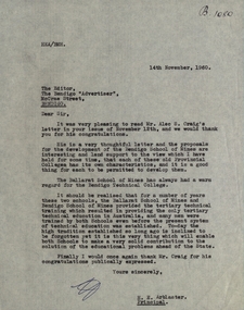
Document - Document - Correspondence, Ballarat School of Mines: Letter to Editor of Bendigo "Advertiser" from H E Arblaster, 14th November 1960
... location was the south end of Lydiard Street. Ballarat Junior Technical School began in 1913 and was boys only until 1951 when girls were included. They were under the control...location was the south end of Lydiard Street. Ballarat Junior Technical School began in 1913 and was boys only until 1951 when girls were included. They were under the control ...The School of Mines Ballarat began in 1870. It's location was the south end of Lydiard Street. Ballarat Junior Technical School began in 1913 and was boys only until 1951 when girls were included. They were under the control of the School of Mines Council. In 1967 the were three divisions. Each was internally distinguished. Ballarat School of Industries, Ballarat Technical School and Ballarat Institute of Advanced Education. In 1976 B.I.A.E. merged with State College of Victoria Ballarat - formerly Ballarat Teachers' College to become Ballarat College of Advanced Education, later to become Federation University. Letter written by H E Arblaster, Principal of Ballarat School of Mines, to The Editor, The Bendigo Advertiser. Letter refers to a letter written by Alec Craig's proposal for the development of a Bendigo School of Mines. This is a view Arblaster has held for some time.Single page, typed.HEA/BMH top right. B1080 ref for correspondence file.school of mines ballarat, h e arblaster, principle, alec craig, bendigp, bendigo technical school -
 Federation University Historical Collection
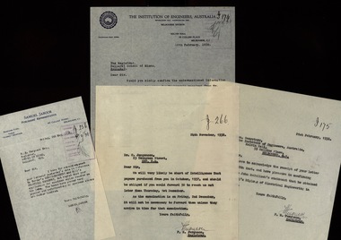
Document - Documents - Correspondence, Ballarat School of Mines: Correspondence with The Institution of Engineers, 1938
... location was the south end of Lydiard Street. Ballarat Junior Technical School began in 1913 and was boys only until 1951 when girls were included. They were under the control...location was the south end of Lydiard Street. Ballarat Junior Technical School began in 1913 and was boys only until 1951 when girls were included. They were under the control ...The School of Mines Ballarat began in 1870. It's location was the south end of Lydiard Street. Ballarat Junior Technical School began in 1913 and was boys only until 1951 when girls were included. They were under the control of the School of Mines Council. In 1967 the were three divisions. Each was internally distinguished. Ballarat School of Industries, Ballarat Technical School and Ballarat Institute of Advanced Education. In 1976 B.I.A.E. merged with State College of Victoria Ballarat - formerly Ballarat Teachers' College to become Ballarat College of Advanced Education, later to become Federation University. Correspondence between SMB and The Institution of Engineers, Australia relating to students' applications for membership of the Institution.Twenty-one letters, typed and hand written.Letterhead of The Institution of Engineers, Australia. Samuel Jaboor, Printers' Representativeschool of mines ballarat, institution of engineers, membership, letterhead -
 Federation University Historical Collection
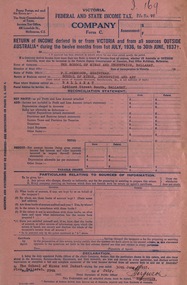
Document, Income Tax Return for School of Mines, 1937
... location was the south end of Lydiard Street. Ballarat Junior Technical School began in 1913 and was boys only until 1951 when girls were included. They were under the control...location was the south end of Lydiard Street. Ballarat Junior Technical School began in 1913 and was boys only until 1951 when girls were included. They were under the control ...The School of Mines Ballarat began in 1870. It's location was the south end of Lydiard Street. Ballarat Junior Technical School began in 1913 and was boys only until 1951 when girls were included. They were under the control of the School of Mines Council. In 1967 the were three divisions. Each was internally distinguished. Ballarat School of Industries, Ballarat Technical School and Ballarat Institute of Advanced Education. In 1976 B.I.A.E. merged with State College of Victoria Ballarat - formerly Ballarat Teachers' College to become Ballarat College of Advanced Education, later to become Federation University. Income Tax Return for the Ballarat School of Mines and Industries for 1937. It is prepared and signed by The Registrar F Ferguson. Names of staff and position listed.Pink coloured form with blue printSignature of F Ferguson - Registrarschool of mines, ballarat, f ferguson, tax return, registrar, sidney chambers, hester darby, thomas gordon, harry goldsmith, augustus heseltine, principal, donald johnston, daniel mullins, hubert murphy, gertrude mcilvens, edgar mcconnon, mavis mctaggart, james pound, richard richards, herbert smith, john sutherland, thomas trengrove, james lochhead, harold yates, albert williams, f g procter, loyal finch, mabel grigg, william coates, victor greenhalgh, h brew, frank ponsonby, thomas gardiner, george cornell, a a jones, ruby lonie, fergus ferguson, h e hewitt, h l coburn, eleanor wright, angus henderson, hubert cochrane, james chandler, e g quilliam, annie jones, annie a. jones, gladstone procter, university women -
 The Beechworth Burke Museum
Photograph, c1960
... location the photograph was taken are also unknown. Perhaps in the Beechworth or Stanley area. Unknown what the photo is referencing, however, there is perhaps an old wooden pump house near a large body of water. Located inside the pump house is an old rusted steam engine, dated c1900, which could have controlled...location the photograph was taken are also unknown. Perhaps in the Beechworth or Stanley area. Unknown what the photo is referencing, however, there is perhaps an old wooden pump house near a large body of water. Located inside the pump house is an old rusted steam engine, dated c1900, which could have controlled ...The date this photograph was taken is unknown. Estimated date 1960-70s. The gentleman in the photograph and location the photograph was taken are also unknown. Perhaps in the Beechworth or Stanley area. Unknown what the photo is referencing, however, there is perhaps an old wooden pump house near a large body of water. Located inside the pump house is an old rusted steam engine, dated c1900, which could have controlled the flow of water. The photo is associated to another record, 6856 as it has the same elderly gentlemen in the image. He is able to be identified through wearing the same clothes and distinctive hat in both photographs. The photograph could be associated to mining as the gentleman is standing next to a small mine site in a related record. Colour rectangular photograph printed on glossy photographic paper. Obverse: Reverse: 6857/ colour photograph, beechworth, burke museum, mining, miners, stanley -
 Eltham District Historical Society Inc
Photograph, Liz Pidgeon, Heritage Excursion; Eltham Lower Park Walk and Talk, 1 July 2017, 1 July 2017
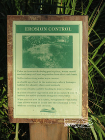
... Information board titled "erosion control" including a photo and causes produced by the Shire of Nillumbik Newsletter No., 234, June 2017 Heritage Excursion - Saturday 1st July - Eltham Lower Park - Walk and Talk Eltham Lower Park has played an important part in the history of our area since the early days of European settlement when it was used by local residents as an informal racecourse. Prior to that its location...Eltham District Historical Society Inc 728 Main Rd Eltham melbourne Information board titled "erosion control" including a photo and causes produced by the Shire of Nillumbik Newsletter No., 234, June 2017 Heritage Excursion - Saturday 1st July - Eltham Lower Park - Walk and Talk Eltham Lower Park has played an important part in the history of our area since the early days of European settlement when it was used by local residents as an informal racecourse. Prior to that its location ...Information board titled "erosion control" including a photo and causes produced by the Shire of Nillumbik Newsletter No., 234, June 2017 Heritage Excursion - Saturday 1st July - Eltham Lower Park - Walk and Talk Eltham Lower Park has played an important part in the history of our area since the early days of European settlement when it was used by local residents as an informal racecourse. Prior to that its location at the junction of the Diamond Creek and the Yarra River made it an important meeting place for the Wurundjeri people. The park combines formal elements and sporting facilities with remnant bushland that is of environmental significance. It is home to sporting and horse riding clubs, popular play spaces and the Diamond Valley Miniature Railway, which attracts large numbers of visitors. The park will be the venue for our July excursion which will comprise a walk of about 3.5 km around the park and adjacent areas. Along the way we will discuss the history and natural history of the area. The path along the creek and the river provides a pleasant and scenic walk. This walk on Saturday 1st July is about 3.5 km in length and will take 2 to 2.5 hours. It will start at 2pm at the Main Road car park at the front of the park. (Melway ref 21 H 10). Born Digitalheritage excursion, activities, eltham district historical society, eltham lower park, erosion, information board -
 Bendigo Historical Society Inc.
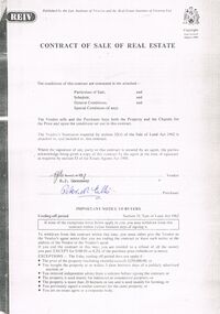
Document - PETER ELLIS COLLECTION: CONTRACT OF SALE
... Loose pages include Building Control Act 1981 Inspection Notice, two plans of building, Three plans (Coliban Water Asset Location) of Flora Lane where property is situated, 2 dated 13/11/2007 (have New Carport drawn beside house) and 1 dated 22/11/2007. ...Loose pages include Building Control Act 1981 Inspection Notice, two plans of building, Three plans (Coliban Water Asset Location) of Flora Lane where property is situated, 2 dated 13/11/2007 (have New Carport drawn beside house) and 1 dated 22/11/2007. ...Copy of Contract of Sale of Real Estate and associated papers for property located in Flora Lane, Flora Hill which was purchased by Peter Ellis on 26 May 1993. Contract is in booklet with other loose papers. Contract includes General Conditions, Particulars of Sale, Special Conditions, Guarantee, Vendors Statement to the Purchaser, Shire of Strathfieldsaye Land Information Certificate, Planning Certificate Request for Building Approval Particulars, Coliban Region Water Authority Information Statement, Property Inquiry Application Form, Request for Property Information from Vic roads, Advice on Mine Subsidence Hazard (Department of Energy & Minerals), Map, Copy of Certificate of Title and Folder Numbers. Loose pages include Building Control Act 1981 Inspection Notice, two plans of building, Three plans (Coliban Water Asset Location) of Flora Lane where property is situated, 2 dated 13/11/2007 (have New Carport drawn beside house) and 1 dated 22/11/2007. Last page has specifications for car port.bendigo, house, peter ellis oam, peter ellis collection, reiv, law institute of victoria, real estate institute of victoria ltd, e j gannaway, peter n ellis, ray white bendigo pty ltd, e m monotti & son, rogers and every, craig watts, shire of strathfieldsaye, coliban region water authority, sec, g & fc of vic, telecom, vicroads, bruce l phillips, k deps?, department of energy and minerals, robert james sanderson, t flanagan, land titles office victoria, harston partridge & co pty ltd -
 Flagstaff Hill Maritime Museum and Village
Footwear - Boots, Rossiters Ltd, 1908-1920
... controlled machines for cutting, sewing, and attaching soles. These changes occurred whilst many of Rossi's competitors moved offshore. Whilst the introduction of these machines reduced the number of local staff, it has enabled Rossi Boots to continue to manufacture in Australia. In March 2019 Rossi Boots relocated the factory, warehouse, and headquarters from Hilton to Kilburn, South Australia. This move to a new, expansive location...controlled machines for cutting, sewing, and attaching soles. These changes occurred whilst many of Rossi's competitors moved offshore. Whilst the introduction of these machines reduced the number of local staff, it has enabled Rossi Boots to continue to manufacture in Australia. In March 2019 Rossi Boots relocated the factory, warehouse, and headquarters from Hilton to Kilburn, South Australia. This move to a new, expansive location ...Rossi Boots started in 1910 when Arthur Edward Rossiter resigned from his position as a supervisor at the Adelaide Boot Company and started Rossiters Ltd in a small tin shed in his backyard. A larger factory was needed so the first of three stages of a factory was built. During the Second World War Rossi Boots was a major supplier to the military making hundreds of thousands of boots that saw service in various theatres including New Guinea. The war years saw the number of employees peak at around five hundred. As methods of manufacturing footwear changed as petroleum-based products such as glues, rubbers and plastics have replaced the traditional ones of leather, nails, and threads. More modern machinery was introduced to directly mould soles to the bottom of the boot. At the end of 1987, the company moved from Unley to Hilton this move allowed production to be carried out in a more modern, fit-for-purpose factory. Since then the company has continued to change; introducing computer-controlled machines for cutting, sewing, and attaching soles. These changes occurred whilst many of Rossi's competitors moved offshore. Whilst the introduction of these machines reduced the number of local staff, it has enabled Rossi Boots to continue to manufacture in Australia. In March 2019 Rossi Boots relocated the factory, warehouse, and headquarters from Hilton to Kilburn, South Australia. This move to a new, expansive location allows Rossi Boots to continue manufacturing in South Australia housing all operations under one roof. The items are significant as they show the beginnings of an important manufacturer and innovator that is still in the original founding family's ownership and is producing boots today with exports to many countries. Boots leather lace up brownNonewarrnambool, shipwrecked-coast, flagstaff-hill, flagstaff-hill-maritime-museum, maritime-museum, shipwreck-coast, flagstaff-hill-maritime-village -
 Federation University Historical Collection
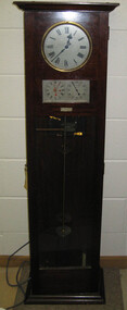
Object, Synchronome Co. Ltd, Synchronome Frequency Checking Master Clock No. 2191, c1930
... control panel in the Power Station. A maximum deviation between the two dials was set in the operating instructions (eg 5 seconds) and the operator would correct this when necessary by remote manual alteration of the turbine governor set point. The clock was used to drive and regulate a system of "slave" clocks which were used to display the time in various locations...control panel in the Power Station. A maximum deviation between the two dials was set in the operating instructions (eg 5 seconds) and the operator would correct this when necessary by remote manual alteration of the turbine governor set point. The clock was used to drive and regulate a system of "slave" clocks which were used to display the time in various locations ...Information from Norman F. Dalton: Ballarat had a reticulated DC supply in the early part of last century and in 1905 had sufficient generating capacity to enable the trams to be changed from horse drawn to DC electricity. The use of electricity increased with the main power station located on Wendouree Parade, near Webster Street, under the ownership of The Electric Supply Company of Victoria. AC generating plant was installed in 1925 and conversion to AC proceeded. In 1934 the company was taken over by the State Electricity Commission Victoria (SECV) and more AC generation was installed and the changeover of customers was accelerated. This is around the time that the Synchronome Frequency Checking Mast Clock was installed at the Wendouree Parade Power Station. The SECV Annual Report of 1921 states: ::Section 11 of the act directed the COmmission to enquire into the question of securing the adoption of such standards of plant and equipment of a system, frequency and pressure for the generation and distribution of electricity as will admit of the efficient interconnection of undertakings throughout the State. In 1934 when the SECV took over the Ballarat operations the question of linking with the State grid had been a planned operation for some years but due to financial considerations had hindered it and in fact would continue to do so for a further 10 years. So while the need for close frequency control for interconnection was hardly an issue, the need to keep electric clocks correct was important, particularly as this item was a frequent sales point to cover the inconvenience and sometimes expense of converting from DC to AC. The clock is a very accurate pendulum clock with provision for varying effective length during operation for precise time regulation. There are two normal time dials and one is controlled by the pendulum and the other is operated by the system frequency. When the clock was in use it was installed by the MEter and Tests Laboratory and the time was checked daily by radio time signals. The two dials were repeated in the operators control panel in the Power Station. A maximum deviation between the two dials was set in the operating instructions (eg 5 seconds) and the operator would correct this when necessary by remote manual alteration of the turbine governor set point. The clock was used to drive and regulate a system of "slave" clocks which were used to display the time in various locations around the power station. A slave clock is a simple clock which is driven by a small electric motor, its accuracy is regulated by the master clock every 30 seconds to ensure that it and all the other slave clocks in the station are on exactly the right time; slave clocks were placed in various locations, from common rooms to workshops. A master clock could potentially run thousands of slave clocks at one plant. The clock also contains a rectifier. A rectifier is a device that is used to convert AC power to more stable DC current.Two clocks in a timber case. Both are electric, one is powered by the main pendulum mechanism, the other is a self contained electric clock. The main mechanism is of the gravity arm and roller type, which sends an impulse to the slave clocks every 30 seconds. The This Synchronome Frequency Checking Master Clock was used at the Ballarat Power Station. Below the main section of the case is a smaller cabinet containing a rectifier to provide consistent DC power for the clock. The rectifier was made by the Victorian company Hilco, which was located in Burwood. There is a high chance this is not the original rectifier from this clock as there appears to be brackets to hold a larger device in the space the rectifier occupies.Front below main clock face on front of case: "Patented Sychronome Brisbane" Lower left-hand clock face: "Frequency time" Lower right-hand clock face: "Standard Seconds" Synchronous electric clock mechanism on door (Frequency time clock): >200/250 V. 50~ >"Synchronomains" Made in England >Direction indicator for clock starting switch >"To start move lever in direction of arrow and release" >"Patent applied for" Mechanism for "standard seconds" clock: >"English Made" >"Patented" >Serial number "321" >0 above right-hand pillar on front-plate Mechanism for "standard seconds" clock: >"English Made" >"Patented" >Serial number "321" >0 above right-hand pillar on front-plate Mechanism for main clock face: >"English Made" >"Patented" >Serial number "8751" >0 above right-hand pillar on front-plate Inside case, back panel, top enamel plate: >Seconds Battery + Pos. > Battery Common or - Neg. >1/2 min dials Inside case, back panel, bottom enamel plate: external seconds dial Inside case, right hand side, electrical knobs: two switches, both "A.C. mains" Pendulum rod, below suspension spring: Serial number (?) 0000005 Rectifier in bottom cabinet: >"Hilco Rectifier" >"A.C. Volts 230/240" >"Model 1060/S" >"A.C. Amperes" >"Serial No. 1060/S >"Phases 1" >"D.C. Volts 6" >"C.P.S. 50" >"D.C. Amperes 1" >"Made in Australia by Hilco Transformers McIntyre St., Burwood, Victoria." Bakelite electrical plug: makers mark Lower cabinet, RH side panel, pressed tin plate: "AC" (upside down) Brass speed adjustment, outer right RH side: "S" and "F" Ivory and wood pendulum beat ruler: >Ruler, with 0 in centre and numbers 1-5 in ascending order from centre on left and right. > "Synchronome Patent." Steel plate, back panel, inside case, right hand side: >N R A" (descending) >"2191" serial number/part number Face of main clock: "Synchronome Electric" synchronome frequency checking master clock, electricity, state electricity commission, wendouree parade power station, secv, clock, time, pendulum, electric supply company of victoria, norman f. dalton, ballarat power station, rectifier, slave clock