Showing 150 items matching "lots 7 "
-
 Glenelg Shire Council Cultural Collection
Photograph - Photograph - Lighthouse Estate, 1952
... ... Lot 7 house...Black and white photo of Lighthouse Estate showing house on Lot 7....Front: Lighthouse Estate 4-12--52. House on Lot 7, printed centre bottom. Back: Purple PHT Stamp 1/4 89 4-12-52...House on Lot 7, printed centre bottom. Back: Purple PHT Stamp 1/4 89 4-12-52 Black and white photo of Lighthouse Estate showing house on Lot 7. ...Port of Portland Authority ArchivesFront: Lighthouse Estate 4-12--52. House on Lot 7, printed centre bottom. Back: Purple PHT Stamp 1/4 89 4-12-52port of portland archives, lighthouse estate, lot 7 house -
 Whitehorse Historical Society Inc.
Document, Land Sales
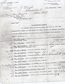
... ...lots 106 - 7...Whitehorse Historical Society Inc. 2-10 Deep Creek Road Mitcham melbourne cock stuart street blackburn whitehorse road mau rooks road mitcham morgan laburnum street lots 25 26 smith carween avenue lot 44 coghill barkly terrace lot 3 moody church street lot 4 cook lot 33 james lot 40 mountford thomas street lot 19 lett game street lot 15 sullivan builders pty ltd glen ebor avenue lot 26 davey mount pleasant road forest hill partridge dunlavin road lots 7 & 8 wright mcdowall street lots 106 - 7 gibb lot 9 Letter from A. ...Letter from A. M. Lonie of Maddock, Jameson & Lonie, solicitors to M.L. Grey Esq , Auctioneer,Letter from A. M. Lonie of Maddock, Jameson & Lonie, solicitors to M.L. Grey Esq , Auctioneer, 800 Whitehorse Rd, Mitcham regarding charging orders for land sales.Letter from A. M. Lonie of Maddock, Jameson & Lonie, solicitors to M.L. Grey Esq , Auctioneer,cock, stuart street, blackburn, whitehorse road, mau, rooks road, mitcham, morgan, laburnum street, lots 25, 26, smith, carween avenue, lot 44, coghill, barkly terrace, lot 3, moody, church street, lot 4, cook, lot 33, james, lot 40, mountford, thomas street, lot 19, lett, game street, lot 15, sullivan builders pty ltd, glen ebor avenue, lot 26, davey, mount pleasant road, forest hill, partridge, dunlavin road, lots 7 & 8, wright, mcdowall street, lots 106 - 7, gibb, lot 9 -
 Ringwood and District Historical Society
Document - Title Search, Lot 1 on Plan of Subdivision 30083W, Lots 12 & 13, 5-7 and 9-11 Homebush Court Ringwood East - 1990
... Lot 1 on Plan of Subdivision 30083W, Lots 12 & 13, 5-7 and 9-11 Homebush Court Ringwood East - 1990...Lot 1 on Plan of Subdivision 30083W, Lots 12 & 13, 5-7 and 9-11 Homebush Court Ringwood East - 1990 Document Title Search ...3 A4 pages - Land Victoria timestamped 18/02/2011. Sole proprietor Brett Clifford Coopersmith. References include Vol 09989 Folio 243, CT Vol 8171 Fol 598 & CT Vol 8213 Fol 101. -
Glenelg Shire Council Cultural Collection
Photograph - Photograph - Lighthouse Estate, 1953
... Black and white photograph of houses on Lots 6 and 7 at Lighthouse Estate....Front: Lighthouse Estate 23-2-53 Houses on Lot 6 and 7 typed centre bottom. Back: Purple PHT Stamp 1/8 145 (blue biro) 23-2-53 in black ink....Black and white photograph of houses on Lots 6 and 7 at Lighthouse Estate. Photograph Photograph - Lighthouse Estate ...Port of Portland Authority ArchivesFront: Lighthouse Estate 23-2-53 Houses on Lot 6 and 7 typed centre bottom. Back: Purple PHT Stamp 1/8 145 (blue biro) 23-2-53 in black ink.port of portland archives, lighthouse estate -
Whitehorse Historical Society Inc.
Legal record - Document, Certificate of Title, 1920
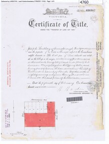
... Certificate of Title vol. 4395 fol. 878940, 25 November 1920, mortgage and rate notices for Lot 7 (410), Middleborough Road, owned by George Gay...Whitehorse Historical Society Inc. 2-10 Deep Creek Road Mitcham melbourne Gay George Shire of Blackburn and Mitcham Middleborough Road Blackburn No.410 Certificate of Title vol. 4395 fol. 878940, 25 November 1920, mortgage and rate notices for Lot 7 (410), Middleborough Road, owned by George Gay Certificate of Title vol. 4395 fol. 878940, 25 November 1920, mortgage and rate notices for Lot 7 (410), Middleborough Road, owned by George Gay Certificate of Title Legal record Document ...Certificate of Title vol. 4395 fol. 878940, 25 November 1920, mortgage and rate notices for Lot 7 (410), Middleborough Road, owned by George GayCertificate of Title vol. 4395 fol. 878940, 25 November 1920, mortgage and rate notices for Lot 7 (410), Middleborough Road, owned by George GayCertificate of Title vol. 4395 fol. 878940, 25 November 1920, mortgage and rate notices for Lot 7 (410), Middleborough Road, owned by George Gaygay, george, shire of blackburn and mitcham, middleborough road blackburn, no.410 -
 Ballarat RSL Sub-Branch Inc.
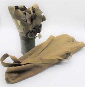
Gas mask US, Cambridge University Press, 1940s
... On interior of mask, “US MI/LOT/7 3SC.”...On interior of mask, “US MI/LOT/7 3SC.” Khaki colour gas mask constructed from cylindrical tin with open valve filter, attached to a plastic mask which attaches to the face with adjustable canvas straps. ...Gas mask similar in style to 1339.1, possibly dating from the 1940s. This mask and associated case were intended for noncombatant use i.e. for use by civilians during wartime.Khaki colour gas mask constructed from cylindrical tin with open valve filter, attached to a plastic mask which attaches to the face with adjustable canvas straps. Mask includes two circular cut outs with plastic windows with valve on left hand side. Printed instructions on canister. “MED ADULT” embossed on top centre of the mask component. On interior of mask, “US MI/LOT/7 3SC.”gas mask, equipment, civilian, gas warfare, second world war, world war two, world war ii, mustard gas, chemical warfare -
 Ringwood and District Historical Society
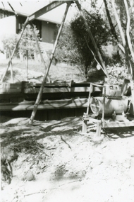
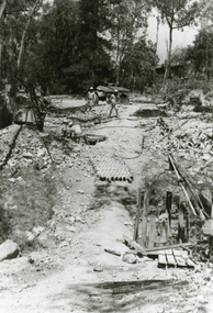
Photographs, 1979-80 MMBW pipe line project at Hubbard Reserve, North Ringwood � Boring hole in lot 7
... 1979-80 MMBW pipe line project at Hubbard Reserve, North Ringwood � Boring hole in lot 7...E561 N4 Feb 1980 A43 The boring hole, 39' deep, at lot 7 (Clarke's, 39 Burlock Ave) with the generator used to supply light....Ringwood and District Historical Society 125A Warrandyte Road Ringwood North melbourne E561 N4 Feb 1980 A43 The boring hole, 39' deep, at lot 7 (Clarke's, 39 Burlock Ave) with the generator used to supply light. ...Part of a 43-photo record of the MMBW�s engineering feat in drilling a 12 inch pipe line up to 40 feet deep through rock hardened by volcanic action associated with geological fault that occurs along the line. The work took place from October 1979 to May 1980 on the southern boundary of Hubbard Reserve, North Ringwood. The collection was presented to the Ringwood Historical Research Group by J Clarke on 9th June 1980.E561 N4 Feb 1980 A43 The boring hole, 39' deep, at lot 7 (Clarke's, 39 Burlock Ave) with the generator used to supply light. -
 Bendigo Historical Society Inc.
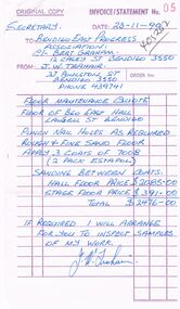
Document - BERT GRAHAM COLLECTION: BENDIGO EAST PROGRESS ASSOCIATRION, 23/11/1990
... Document, Bert Graham Collection, Bendigo East Progress Association, two (2) quotes for the hall floor.J.W Trahair, 27 Poulston Street, Bendigo for $2476.00, and Arthur Wilson, Lot 7, Chaikley's Road, Goornong, for $1674.45....History House 11 Mackenzie Street Bendigo goldfields BENDIGO Clubs bendigo east swimming club Document, Bert Graham Collection, Bendigo East Progress Association, two (2) quotes for the hall floor.J.W Trahair, 27 Poulston Street, Bendigo for $2476.00, and Arthur Wilson, Lot 7, Chaikley's Road, Goornong, for $1674.45. ...Document, Bert Graham Collection, Bendigo East Progress Association, two (2) quotes for the hall floor.J.W Trahair, 27 Poulston Street, Bendigo for $2476.00, and Arthur Wilson, Lot 7, Chaikley's Road, Goornong, for $1674.45.bendigo, clubs, bendigo east swimming club -
 Ringwood and District Historical Society
Photographs, 1979-80 MMBW pipe line project at Hubbard Reserve, North Ringwood � Tunnel shafts
... E561 N12 Feb 1980 A43 Line of tunnel shafts at 29-30 Burlock Avenue showing swivel cranes 5 and 6 from the bore-hole in Lot 7...Ringwood and District Historical Society 125A Warrandyte Road Ringwood North melbourne E561 N12 Feb 1980 A43 Line of tunnel shafts at 29-30 Burlock Avenue showing swivel cranes 5 and 6 from the bore-hole in Lot 7 Part of a 43-photo record of the MMBW�s engineering feat in drilling a 12 inch pipe line up to 40 feet deep through rock hardened by volcanic action associated with geological fault that occurs along the line. ...Part of a 43-photo record of the MMBW�s engineering feat in drilling a 12 inch pipe line up to 40 feet deep through rock hardened by volcanic action associated with geological fault that occurs along the line. The work took place from October 1979 to May 1980 on the southern boundary of Hubbard Reserve, North Ringwood. The collection was presented to the Ringwood Historical Research Group by J Clarke on 9th June 1980.E561 N12 Feb 1980 A43 Line of tunnel shafts at 29-30 Burlock Avenue showing swivel cranes 5 and 6 from the bore-hole in Lot 7 -
 The 5th/6th Battalion Royal Victoria Regiment Historical Collection
Container - Explosive Ordnance-CES, Grenade create, 1958
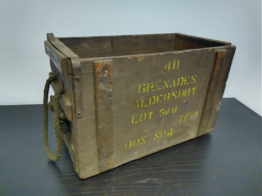
... 40 Grenades Aldershot Lot 548 7/58 Box No 4...The 5th/6th Battalion Royal Victoria Regiment Historical Collection 202 Burwood Rd Hawthorn melbourne Wark VC Club CES Ammunition 40 Grenades Aldershot Lot 548 7/58 Box No 4 wooden box with rope handles , metal brackets and a metal bracket to hold lid down. ...wooden box with rope handles , metal brackets and a metal bracket to hold lid down.40 Grenades Aldershot Lot 548 7/58 Box No 4wark vc club, ces, ammunition -
 Mt Dandenong & District Historical Society Inc.
Photograph
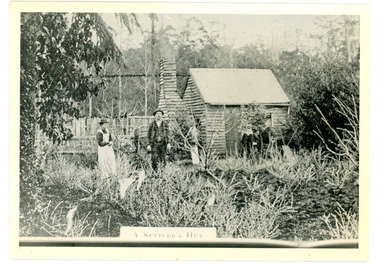
... The Keoghs took up Lot 7 in the Village Settlement in 1905. John Keogh was a big Irishman and cleared many of the giant trees on his Lot 7. ...Farndons Community Hall 42 Falls Road Mt Dandenong yarra-valley-and-the-dandenong-ranges The Keoghs took up Lot 7 in the Village Settlement in 1905. John Keogh was a big Irishman and cleared many of the giant trees on his Lot 7. ...The Keoghs took up Lot 7 in the Village Settlement in 1905. John Keogh was a big Irishman and cleared many of the giant trees on his Lot 7. They had little water for their crops so grew gooseberries and red currants rather than the more valuable strawberries. Mrs Keogh (nee Cleary) inherited money in 1906 and they built a new weatherboard house. The original bush hut remained as the kitchen. Son James (Jimmie) married Mary Walsh, a teacher at the local school. Jimmie built the small shop on the triangle of land cut off when the CRB road went through. Jimmie and his wife left the district when he joined Victoria Police. Jimmie came back to the area and finally sold the land of Lot 7 to Rimington's Nurseries. He moved his family to Kilsyth. In 1939 the shop was moved across the road to be used as an office by the road builders. It burned down that year.Black and white photograph of a man, woman and young male standing outside a wooden hut. There are crop remnants in the foreground and a wooden paling fence behind the hut. A label on the front reads A SETTLER'S HUT. Reverse of photograph has handwritten description by John Lundy-Clarke.Front: A SETTLER'S HUT Reverse: 1905 Keogh's hut on Falls Road then Main Road. This was later the kitchen of their extended home as described in the narrative "Mountain of Struggle". The figures are - Mrs Keogh. John Keogh settler. Son James Keogh.keogh, john keogh, james keogh, jimmie keogh, mary walsh, cleary, shop, store, gooseberries, rimington's nursery -
 Greensborough Historical Society
Certificate of Title, Certificate of Title Vol. 3182 Fol. 302, 15/02/1907
... Title in the name of Joseph Laidlay of Greensborough, fruitgrower, 14 acres being Lots 7, 8 and 22 on Plan of subdivision 4759, part of Crown portion 17, Parish of Keelbundora County of Bourke, dated 15th February 1907. ...Greensborough Historical Society 34A Glenauburn Road Lower Plenty Lower Plenty melbourne Title in the name of Joseph Laidlay of Greensborough, fruitgrower, 14 acres being Lots 7, 8 and 22 on Plan of subdivision 4759, part of Crown portion 17, Parish of Keelbundora County of Bourke, dated 15th February 1907. ...Title in the name of Joseph Laidlay of Greensborough, fruitgrower, 14 acres being Lots 7, 8 and 22 on Plan of subdivision 4759, part of Crown portion 17, Parish of Keelbundora County of Bourke, dated 15th February 1907. Northern boundary Greensborough (now Grimshaw) Road, Eastern boundary Henry Street.1 p. colour copy of Titlegreensborough, grimshaw street greensborough, henry street greensborough, joseph laidlay -
 Mt Dandenong & District Historical Society Inc.
Photograph
... Jim Keogh owned Lot 7 of the Village Settlement. When the new CRB road went through c1920 his block was cut through leaving a small triangle of land on the high side of the CRB road. ...Farndons Community Hall 42 Falls Road Mt Dandenong yarra-valley-and-the-dandenong-ranges Jim Keogh owned Lot 7 of the Village Settlement. When the new CRB road went through c1920 his block was cut through leaving a small triangle of land on the high side of the CRB road. ...Jim Keogh owned Lot 7 of the Village Settlement. When the new CRB road went through c1920 his block was cut through leaving a small triangle of land on the high side of the CRB road. He built a shop on this piece of land. The store burned down 31/12/1939. The woman on the step in this photo is Win Woodcock.Sepia image of a woman standing in front of a wooden store. Handwritten inscription on reverse by John Lundy-ClarkeJim Keogh's shop on the north west corner of Falls and Main Roads. Opposite diagonally from St Michael's Church of England. photo Nov 1926.jim keogh, keogh, store, shop, crb road, win woodcock -
 Ringwood and District Historical Society
Document - Folder, Reaghill Estate Subdivision, Ringwood, Victoria - circa 1958
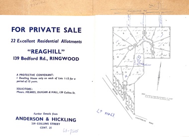
... Bifold land sale brochure glued to brown stationery folder with advertisement including map of original subdivision (circa 1958) and subsequent 1982 re-subdivision of Lot 7 Vista Avenue - LP41463 - Part of Crown Allotment 43, Parish of Ringwood, and 4-page brochure for sale of 4 luxury new homes built by Bovis Homes Aust. ...Bifold land sale brochure glued to brown stationery folder with advertisement including map of original subdivision (circa 1958) and subsequent 1982 re-subdivision of Lot 7 Vista Avenue - LP41463 - Part of Crown Allotment 43, Parish of Ringwood, and 4-page brochure for sale of 4 luxury new homes built by Bovis Homes Aust. ...Bifold land sale brochure glued to brown stationery folder with advertisement including map of original subdivision (circa 1958) and subsequent 1982 re-subdivision of Lot 7 Vista Avenue - LP41463 - Part of Crown Allotment 43, Parish of Ringwood, and 4-page brochure for sale of 4 luxury new homes built by Bovis Homes Aust. P/L as presented by Lyndsay Edmonds Homes. Subdivision includes Bedford Road, Homebush Court, Vista Avenue and Vista Court. Original protective covenant: "One dwelling house only on each of Lots 1-15 for a period of 15 years". Agent - Anderson & Hickling, 239 Collins Street, Melbourne. (Phone) Cent.25. -
 Ringwood and District Historical Society
Map, Borough of Ringwood, Victoria - Proposed Subway Road - 1943
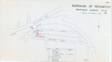
... Taylor, Lot 6 R.S. Sharp, Lot 7 William J. Wakeham, Lot 8 Janet R. Gibson /Mrs C. ...Taylor, Lot 6 R.S. Sharp, Lot 7 William J. Wakeham, Lot 8 Janet R. Gibson /Mrs C. ...Technical drawing by D.H. Oliver dated 22/9/43 showing residential lots affected by proposed road extending from Warrandyte Road railway underpass into Pitt Street and Bedford Road. Includes list of owners and occupiers of properties - Lot 4 Stanley Harris /R. Taylor, Lot 6 R.S. Sharp, Lot 7 William J. Wakeham, Lot 8 Janet R. Gibson /Mrs C. Burden, Lot 9 Mrs McClelland, Lot 10 part Mrs. Yetts, Lot 11 part 10 Church of Christ, Lot 54 Mrs Shwerkolt, Lot 55 Mrs Goodall.Scale: 2 chains = 1 inch. -
 Sunshine and District Historical Society Incorporated
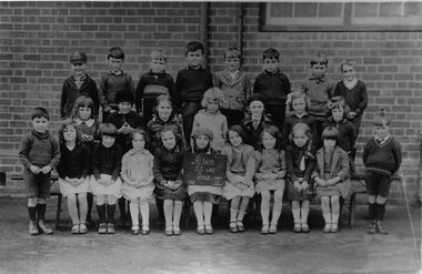
Mixed media - Albion State School No. 4265 1932 Grade II & Lot 267 (No 7) Sydney St Albion Title Deeds, 1932; ?
... Albion State School No. 4265 1932 Grade II & Lot 267 (No 7) Sydney St Albion Title Deeds...Photo of Grade II students of Albion State School in 1932 Grade II Three photocopies of the title deeds of Lot 267 (No 7) Sydney St Albion Sunshine 21st March 1912....Mixed media Albion State School No. 4265 1932 Grade II & Lot 267 (No 7) Sydney St Albion Title Deeds ...albion state school, state school, adelaide street, albion, student photograph -
 Ringwood and District Historical Society
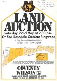
Flyer, Land Auction, Rosedale Crescent, Ringwood East - 1976
... Lot 1 Council Reserve. Lot 2 PI 16750. Lot 7 PI 13250. Lot 8 PI 13350. Lot 9 PI 13500. ...Lot 1 Council Reserve. Lot 2 PI 16750. Lot 7 PI 13250. Lot 8 PI 13350. Lot 9 PI 13500. ...Single page advertisement for auction of 7 residential blocks in Rosedale Crescent, Ringwood on 22nd May, 1976.Vendor Terms $1,500 deposit. Agent - Covey Wilson Pty Ltd., Ashley House, 409 St.Kilda Road, Melbourne. Phone 2674022 AH 805062, 7892533. Handwritten notation "LP 97896 Vol 9038 Fol 283, seven available lots 9, 10, 11, 12. Other lots on request Res C." Lot 1 Council Reserve. Lot 2 PI 16750. Lot 7 PI 13250. Lot 8 PI 13350. Lot 9 PI 13500. Lot 11 PI 12750. Lot 12 Sold 13500(?). -
 Mt Dandenong & District Historical Society Inc.
Photograph
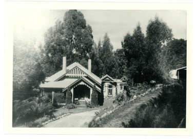
... Alf Dorey took up LOTs 6 and 7 in Section 2 . He lived in a house of split timbers on the slope west of where 'The Welkin' was built. ...Farndons Community Hall 42 Falls Road Mt Dandenong yarra-valley-and-the-dandenong-ranges Alf Dorey took up LOTs 6 and 7 in Section 2 . He lived in a house of split timbers on the slope west of where 'The Welkin' was built. ...Alf Dorey took up LOTs 6 and 7 in Section 2 . He lived in a house of split timbers on the slope west of where 'The Welkin' was built. Alf sold his LOTs in sections - a piece of LOT 6 going to Edwin L Bell who engaged Ern Badenhop to build a house known as The WelkinBlack and white photograph showing a driveway leading to an ornate house nestled in the trees. Another building can be seen on the rhs. Reverse of photograph has handwritten description by John Lundy-Clarke."The Welkin" Built about 1919 for Bell of matchmaking fame, by Ern Badenhop on Lot 6 Sect 2 Vill. Set. A. DOREY's. Was run as a guest house by Peters family.alf dorey, edwin l bell, bell, ern badenhop, badenhop, the welkin, welkin, peters -
 Eltham District Historical Society Inc
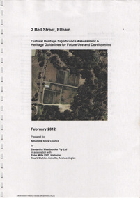
Document, Samantha Westbrooke Pty Ltd et al, 2 Bell Street, Eltham: Cultural Heritage Significance Assessment & Heritage Guidelines for Future Use & Development, 2012
... The site for the village of Eltham was surveyed in 1851 and the Township Plan shows that the property is made up of Lots 7 and 8 which were sold at auction in June 1852 to M. ...The site for the village of Eltham was surveyed in 1851 and the Township Plan shows that the property is made up of Lots 7 and 8 which were sold at auction in June 1852 to M. ...Prepared for Nillumbik Shire Council by Samantha Westbrooke Pty Ltd in association with Peter Mills PhD, Architectural Historian and Roark Muhlen-Schilte, Archaeologist. Covers history of early market gardening in Eltham with the commencement of European settlement in the late 1830s. The site for the village of Eltham was surveyed in 1851 and the Township Plan shows that the property is made up of Lots 7 and 8 which were sold at auction in June 1852 to M. O'Shea. The history of the Bell Street property is closely tied to the West family from the 1860s to 1930s; the earliest rate books for Eltham show William West farming in El;tham in 1864. In the aerly 1930s ownership of the creek side was transferred from the west family to the Fabbro family who shortly afterwards were impaced by the 1934 Diamond Creek flooding. Guido Fabbro relocated the original West home further up the hill and built a new Italianate style modern home in situ. The Fabbro family farmed the property. In 1993/4 Eltham Council acquired the creek-side market garden blocks to the south of 2 Bell Street which was recconceived in 1998 as the Barak Bushland Reserve. The Fabbro house was demolished shortly after and the lots were sold to a developer in 1994. The large steel shed now present on the 2 Bell Street property dates from soon after this sale.26 A4 pages color printcultural heritage significance assessment, peter mills, samantha westbrooke pty ltd, shire of nillumbik, 2 bell street, eltham, market gardening, west family, fabbro family, land use, barak bushland reserve, heritage assessment -
 Ringwood and District Historical Society
Newspaper, Scrapbook Clipping, Library Collection, Ringwood, Victoria
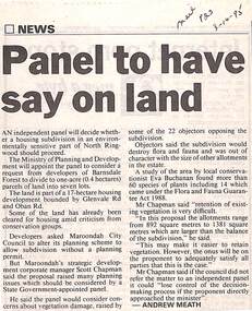
... The Ministry of Planning and Development will appoint the panel to consider a request from developers of Barnsdale Forest to divide one acre (0.4 hectares) parcels of land into 7 lots...The Ministry of Planning and Development will appoint the panel to consider a request from developers of Barnsdale Forest to divide one acre (0.4 hectares) parcels of land into 7 lots Newspaper Clipping from "The Mail", 3-10-95. ...Newspaper Clipping from "The Mail", 3-10-95. P23. By Andrew Meath. Panel to have Say on LandAn independent panel will decide whether a housing subdivision in an environmentally sensitive part of North Ringwood should proceed. The Ministry of Planning and Development will appoint the panel to consider a request from developers of Barnsdale Forest to divide one acre (0.4 hectares) parcels of land into 7 lots -
 Eltham District Historical Society Inc
Photograph, Fay Bridge, Footbridge, Fort Knox Self Storage, 197 Sherbourne Road, Eltham, n.d
... The 1911 subdivision of this farm created Lot 7 of some seven acres, which is the site of this factory. ...The 1911 subdivision of this farm created Lot 7 of some seven acres, which is the site of this factory. ...The footbridge which extended from the facility to the landscaped garden and water features is now gone. The footbridge and garden were previously part of a former hat factory in Sherbourne Road Eltham which has in the past been used for various purposes and presently a self storage business. The Karingal Yallock Creek passes through the front of the land and the creek environs are the subject of significant and unusual landscaping works, including some cascading water channels. Some of the landscaping was damaged by the Christmas Day floods of 2011, but the main elements remain intact. The landscaped area (as distinct from the factory itself) is the subject of a Heritage Overlay under the Nillumbik Planning Scheme. The basis of this overlay is a Heritage Report by Graeme Butler and Associates in 2006. As well as an assessment of the landscaped area, it includes one background information on the history of the site (although a complete history would require more research). The site was part of Crown Portion 3 of the Parish of Nillumbik that remained as the Montmorency Farm until early in the twentieth century. The 1911 subdivision of this farm created Lot 7 of some seven acres, which is the site of this factory. The Heritage Report lists the various owners of the site. From the rate records and aerial photos it is concluded that the site was used as an orchard and farmland until the 1940s. William F Crellin, orchardist, owned the site from 1912 to 1923. Then Edmund Williams owned it until 1951. In 1955 the site was owned by Rupert V. Kirsch and this is the name anecdotally associated with the hat factory, where the well-known brand of Fayrefield Hats were manufactured. There is some belief that this was built about the time of the Second World War and that hats for the armed forces were made there.fay bridge collection, eltham, fayrefield hat factory, foot bridge, sherbourne road, footbridge, fort knox eltham -
 Ringwood and District Historical Society
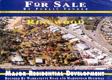
Flyer, Residential Development Sale by Public Tender, Ringwood, Victoria - 1993
... Total land 30,900 square metres. Lots 3 to 7 have plans available for 207 units. ...Total land 30,900 square metres. Lots 3 to 7 have plans available for 207 units. ...Double-sided brochure with map advertising major residential development bounded by Warrandyte Road and Maroondah Highway, Ringwood. Seven allotments facing Aird Street, Pratt Street, Bardia Street, Larissa Avenue and Suda Avenue offered as a whole or separately. Total land 30,900 square metres. Lots 3 to 7 have plans available for 207 units. Tenders close 5pm 12th August 1993. Agents - Michael Lewin, Simon Conquest, Talbot Birner Morley, 191 Balaclava Road Caulfield North (Tel) 5259222. -
 Bendigo Military Museum
Document - INSTRUCTIONS, ARMY TRAINING, STEWARDS COURSE, Aust Army, unknown
... Sgts Mess Stocktake. 7. Lots of additions, prices and mistakes....Sgts Mess Stocktake. 7. Lots of additions, prices and mistakes. 1. ...4. Mess Operation, setting of table, folding serviettes, tapping a keg of beer. 7. The prices will bring tears to your eyes, i.e. Packets of cigarettes 38 - 41 cents each.1. A4 size - culinary terms. RAASC Centre Puckapunyal - 5 pages. 2. Foolscap - Systems of food service. RAASC centre, Oct 1962 - 6 pages. 3. Foolscap - kitchen & personal hygiene, RAASC Centre Aug 1964 - 6 pages. 4. Foolscap - Mess Operation. RAASC Centre - 29 pages - Jan 1960. 5. A4 size - 1/71 Basic Stewards Course 3 Feb, 7-24 Feb 1971. GTF Area. 6. Single sheet ASCO Mess Requisition Form - N40A Dated 8/2/71. 7. 6 Task Force SGS Mess Stocktake and cash results.1. 3795952 Pte W.D. Patterson - has some ticks and pencilled changes. 2. 3795952 Pte W.D. Patterson. 3. 3795952 Pte W.D. Patterson. 4. 3795952 Pte W.D. Patterson. 5. Red ink amendments - dates & ticks. 6. ASCO form N.40A Mess requisition NR 67510 - Cannon Hill, Enogerra. 8/2/71. Sgts Mess Stocktake. 7. Lots of additions, prices and mistakes.messing, aust army -
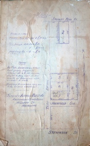
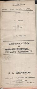 Bendigo Historical Society Inc.
Document - H.A. & S.R. WILKINSON COLLECTION: CONTRACT OF SALE
... Taylor (buyer) for land situate Hodgkinson Street, Bendigo having a frontage of approx. 52 feet by a depth of approx. 108 feet, being parts of lots 6 and 7 on plan of subdivision registered No.13862 part of Crown allotments 6 and 7 section 38C land described in Crown grant volume 1502 folio 300225 and Crown grant volume 2642 folio 528242. ...Taylor (buyer) for land situate Hodgkinson Street, Bendigo having a frontage of approx. 52 feet by a depth of approx. 108 feet, being parts of lots 6 and 7 on plan of subdivision registered No.13862 part of Crown allotments 6 and 7 section 38C land described in Crown grant volume 1502 folio 300225 and Crown grant volume 2642 folio 528242. ...This business was owned by father and son, Henry Archibald Wilkinson and Samuel Ronald "Ron" Wilkinson. Henry (1882-1954) was born in Shepparton and died in Bendigo. He was married to Grace Hovendon in 1908. Samuel Ronald "Ron" (1914-1995), Henry's son, was married to Florence Jean McKerlie in 1937.Conditions of sale by private contract dated 21st. October, 1935 between J. Mahon (seller) and H. Taylor (buyer) for land situate Hodgkinson Street, Bendigo having a frontage of approx. 52 feet by a depth of approx. 108 feet, being parts of lots 6 and 7 on plan of subdivision registered No.13862 part of Crown allotments 6 and 7 section 38C land described in Crown grant volume 1502 folio 300225 and Crown grant volume 2642 folio 528242. Price 50 pounds. Attached receipt and plans to build house on that land (W. H. Ellis builder) for 500 pounds also attached detailed list of materials and labour.organization, business, h.a. & s.r wilkinson real estate -
 Kew Historical Society Inc
Plan, Sydney Arnold Best & Co, Field Place, Kew, c.1929
... The first attempted subdivision of Tara Hall was advertised in 1927 in which Lots 5, 6 and 7 in this plan were also advertised. ...The first attempted subdivision of Tara Hall was advertised in 1927 in which Lots 5, 6 and 7 in this plan were also advertised. ...Pru Sanderson, in her groundbreaking ‘City of Kew Urban Conservation Study : Volume 2 - Development History’ (1988), summarised the periods of urban development and subdivisions of land in Kew. The periods that she identified included 1845-1880, 1880-1893, 1893-1921, 1921-1933, 1933-1943, and Post-War Development. These periods were selected as they represented periods of rapid growth or decline in urban development. An obvious starting point for Sanderson’s groupings involved population growth and the associated economic cycles. These cycles also highlighted urban expansion onto land that was predominantly rural, although in other cases it represented the decline and breakup of large estates. A number of the plans in the Kew Historical Society’s collection can also be found in other collections, such as those of the State Library of Victoria and the Boroondara Library Service. A number are however unique to the collection.The Kew Historical Society collection includes almost 100 subdivision plans pertaining to suburbs of the City of Melbourne. Most of these are of Kew, Kew East or Studley Park, although a smaller number are plans of Camberwell, Deepdene, Balwyn and Hawthorn. It is believed that the majority of the plans were gifted to the Society by persons connected with the real estate firm - J. R. Mathers and McMillan, 136 Cotham Road, Kew. The Plans in the collection are rarely in pristine form, being working plans on which the agent would write notes and record lots sold and the prices of these. The subdivision plans are historically significant examples of the growth of urban Melbourne from the beginning of the 20th Century up until the 1980s. A number of the plans are double-sided and often include a photograph on the reverse. A number of the latter are by noted photographers such as J.E. Barnes.An unnamed subdivision in Studley Park including five lots for sale in Studley Park Road, Highfield Grove and Tara Avenue. Unidentified on the plan, but clearly existing, are the Henty family mansion of Field Place and Tara Hall in Studley Park Road. The first attempted subdivision of Tara Hall was advertised in 1927 in which Lots 5, 6 and 7 in this plan were also advertised. Unusually, Lot 2 in Studley Park Road was created from the northern part of the Henty mansion, rather than Tara Hall. In the subdivision, lots were advertised at varying prices, with the highest price for land being Lot 2 in Studley Park Road. The plan notes that only one villa is to be allowed on each allotment.subdivision plans - kew, field place subdivision -- studley park – kew (vic.), highfield grove – kew (vic.), tara avenue – kew (vic.) -
 Eltham District Historical Society Inc
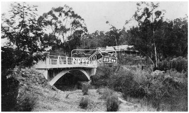
Photograph - Postcard, The Bridge, Hurstbridge, Vic
... It is noted that an advertisement running in The Argus February 22, 1951 offered the remaining 16 blocks for sale at £12.10.0 or £200 the lot. By March 7, the remaining blocks were advertised at £17.10.0 The Wattle Valley Estate took over 20 years to sell and then people could not build on them....It is noted that an advertisement running in The Argus February 22, 1951 offered the remaining 16 blocks for sale at £12.10.0 or £200 the lot. By March 7, the remaining blocks were advertised at £17.10.0 The Wattle Valley Estate took over 20 years to sell and then people could not build on them. michael aitken collection postcards hurstbridge monash bridge Bridge Diamond Creek (Creek) Mia Mia Shire of Eltham Pioneers Photograph Collection Wattle Valley Estate Digital file only Postcards scanned from the collection of Michael Aitken on loan to EDHS, 13 Feb 2018 The Bridge, Hurstbridge, Vic. ...Arched Bridge (Monash Bridge) The Rose Series P. 4036 Reproduced in a brochure advertising the "Wattle Valley Estate" 7 minutes from the bridge. The new bridge designed by Sir John Monash over the Diamond Creek near Hurst's original home "Mia Mia" seen in the distance. The Wattle Valley Estate was first advertised in August 1925 as weekend building allotments by the Greater Melbourne Land and Development Company. Advertised from £28.10.0 or £60 per block. In August 1926, 30 picked allotments of 60x150 feet were put up for auction Saturday August 14, 1926 with frontages to Valley View Road and Fawkner Crescent advertised in the “Heart of the Glorious Wattle Country” and “Within 15 Minutes of the Newly Electrified Railway Station”. The Advertiser on August 13, 1926 in an article promoting the auction stated “the estate is regarded as one of the best in the district, and will be sold practically without reserve.” It is noted that an advertisement running in The Argus February 22, 1951 offered the remaining 16 blocks for sale at £12.10.0 or £200 the lot. By March 7, the remaining blocks were advertised at £17.10.0 The Wattle Valley Estate took over 20 years to sell and then people could not build on them.Digital file only Postcards scanned from the collection of Michael Aitken on loan to EDHS, 13 Feb 2018michael aitken collection, postcards, hurstbridge, monash bridge, bridge, diamond creek (creek), mia mia, shire of eltham pioneers photograph collection, wattle valley estate -
 Eltham District Historical Society Inc
Negative - Photograph, The Bridge, Hurstbridge, Vic, c.1925
... It is noted that an advertisement running in The Argus February 22, 1951 offered the remaining 16 blocks for sale at £12.10.0 or £200 the lot. By March 7, the remaining blocks were advertised at £17.10.0 The Wattle Valley Estate took over 20 years to sell and then people could not build on them This image was also used in a brochure advertising the "Wattle Valley Estate", which forms part of the Shire of Eltham Pioneers Photograph Collection (Cross Reference Photo No....It is noted that an advertisement running in The Argus February 22, 1951 offered the remaining 16 blocks for sale at £12.10.0 or £200 the lot. By March 7, the remaining blocks were advertised at £17.10.0 The Wattle Valley Estate took over 20 years to sell and then people could not build on them This image was also used in a brochure advertising the "Wattle Valley Estate", which forms part of the Shire of Eltham Pioneers Photograph Collection (Cross Reference Photo No. ...Copied from brochure "Wattle Valley Estate" 7 minutes from the bridge. The new bridge designed by Sir John Monash over the Diamond Creek near Hurst's home of 'Mia Mia' at Hurstbridge. The Wattle Valley Estate was first advertised in August 1925 as weekend building allotments by the Greater Melbourne Land and Development Company. Advertised from £28.10.0 or £60 per block. In August 1926, 30 picked allotments of 60x150 feet were put up for auction Saturday August 14, 1926 with frontages to Valley View Road and Fawkner Crescent advertised in the “Heart of the Glorious Wattle Country” and “Within 15 Minutes of the Newly Electrified Railway Station”. The Advertiser on August 13, 1926 in an article promoting the auction stated “the estate is regarded as one of the best in the district, and will be sold practically without reserve.” It is noted that an advertisement running in The Argus February 22, 1951 offered the remaining 16 blocks for sale at £12.10.0 or £200 the lot. By March 7, the remaining blocks were advertised at £17.10.0 The Wattle Valley Estate took over 20 years to sell and then people could not build on them This image was also used in a brochure advertising the "Wattle Valley Estate", which forms part of the Shire of Eltham Pioneers Photograph Collection (Cross Reference Photo No.(s): 1056, 1057)This photo forms part of a collection of photographs gathered by the Shire of Eltham for their centenary project book,"Pioneers and Painters: 100 years of the Shire of Eltham" by Alan Marshall (1971). The collection of over 500 images is held in partnership between Eltham District Historical Society and Yarra Plenty Regional Library (Eltham Library) and is now formally known as the 'The Shire of Eltham Pioneers Photograph Collection.' It is significant in being the first community sourced collection representing the places and people of the Shire's first one hundred years.Digital image 4 x 5 inch B&W Negshire of eltham pioneers photograph collection, hurstbridge, bridge, diamond creek (creek), monash bridge, wattle valley estate -
 Eltham District Historical Society Inc
Negative - Photograph, Rose Stereograph Company, The Bridge, Hurstbridge, Vic, c.1925
... It is noted that an advertisement running in The Argus February 22, 1951 offered the remaining 16 blocks for sale at £12.10.0 or £200 the lot. By March 7, the remaining blocks were advertised at £17.10.0 The Wattle Valley Estate took over 20 years to sell and then people could not build on them This image was also used in a brochure advertising the "Wattle Valley Estate", which forms part of the Shire of Eltham Pioneers Photograph Collection (Cross Reference Photo No....It is noted that an advertisement running in The Argus February 22, 1951 offered the remaining 16 blocks for sale at £12.10.0 or £200 the lot. By March 7, the remaining blocks were advertised at £17.10.0 The Wattle Valley Estate took over 20 years to sell and then people could not build on them This image was also used in a brochure advertising the "Wattle Valley Estate", which forms part of the Shire of Eltham Pioneers Photograph Collection (Cross Reference Photo No. ...Copied from brochure "Wattle Valley Estate". The new bridge designed by Sir John Monash over the Diamond Creek near Hurst's original home "Mia Mia" seen in the distance. Reprinted from brochure advertising "Wattle Valley Estate" 7 minutes from bridge. The Wattle Valley Estate was first advertised in August 1925 as weekend building allotments by the Greater Melbourne Land and Development Company. Advertised from £28.10.0 or £60 per block. In August 1926, 30 picked allotments of 60x150 feet were put up for auction Saturday August 14, 1926 with frontages to Valley View Road and Fawkner Crescent advertised in the “Heart of the Glorious Wattle Country” and “Within 15 Minutes of the Newly Electrified Railway Station”. The Advertiser on August 13, 1926 in an article promoting the auction stated “the estate is regarded as one of the best in the district, and will be sold practically without reserve.” It is noted that an advertisement running in The Argus February 22, 1951 offered the remaining 16 blocks for sale at £12.10.0 or £200 the lot. By March 7, the remaining blocks were advertised at £17.10.0 The Wattle Valley Estate took over 20 years to sell and then people could not build on them This image was also used in a brochure advertising the "Wattle Valley Estate", which forms part of the Shire of Eltham Pioneers Photograph Collection (Cross Reference Photo No.(s): 1056, 1057). Also cross reference SEPP_1028 / 29 for other views of Mia Mia. Part of a slide show presentation "Bridges & Waterways of the Shire" by Russell Yeoman to the 13 September 1989 Society meeting. The presentation included slides of historic photos from the Shire of Eltham Pioneers collections as well as several recent views. This photo forms part of a collection of photographs gathered by the Shire of Eltham for their centenary project book,"Pioneers and Painters: 100 years of the Shire of Eltham" by Alan Marshall (1971). The collection of over 500 images is held in partnership between Eltham District Historical Society and Yarra Plenty Regional Library (Eltham Library) and is now formally known as the 'The Shire of Eltham Pioneers Photograph Collection.' It is significant in being the first community sourced collection representing the places and people of the Shire's first one hundred years.Digital image 4 x 5 inch B&W Negshire of eltham pioneers photograph collection, hurstbridge, mia mia, bridge, diamond creek (creek), monash bridge, wattle valley estate -
 Eltham District Historical Society Inc
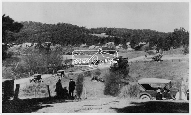
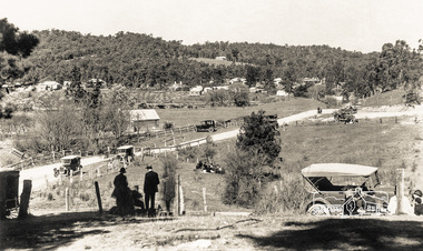
Negative - Photograph, Popular Picnicing at Hurstbridge, c.1925
... It is noted that an advertisement running in The Argus February 22, 1951 offered the remaining 16 blocks for sale at £12.10.0 or £200 the lot. By March 7, the remaining blocks were advertised at £17.10.0 The Wattle Valley Estate took over 20 years to sell and then people could not build on them Cross Ref EDHS_02665 Rose Series Postcard P. 4341, "View at Hurstbridge, Vic." ...It is noted that an advertisement running in The Argus February 22, 1951 offered the remaining 16 blocks for sale at £12.10.0 or £200 the lot. By March 7, the remaining blocks were advertised at £17.10.0 The Wattle Valley Estate took over 20 years to sell and then people could not build on them Cross Ref EDHS_02665 Rose Series Postcard P. 4341, "View at Hurstbridge, Vic." ...Picnickers enjoying a Sunday outing near the Wattle Valley Estate at Hurstbridge. Copied from brochure "Wattle Valley Estate". It is believed the picture is taken at the northwest corner of the intersection of Wattletree Road and Hurstbridge-Arthurs Creek Road looking southeast towards the township (most likely where the house is located on the property of what is today No. 2 Wattletree Road)- https://goo.gl/maps/VDorwCe1rJJUapjE6 According to a comment by Jean Verso (via @nillumbikcouncil FB page 3 Jan 2020) - "This view is from Wattle Tree Road with Haleys Gully Road to the right and across the creek to William Gray's nursery at Allwood. The building to the far left looks like Dorset House. The building on the left in the middle distance is still there today and has been used for storage and as a stable/tack room for a number of years." The Wattle Valley Estate was first advertised in August 1925 as weekend building allotments by the Greater Melbourne Land and Development Company. Advertised from £28.10.0 or £60 per block. In August 1926, 30 picked allotments of 60x150 feet were put up for auction Saturday August 14, 1926 with frontages to Valley View Road and Fawkner Crescent advertised in the “Heart of the Glorious Wattle Country” and “Within 15 Minutes of the Newly Electrified Railway Station”. The Advertiser on August 13, 1926 in an article promoting the auction stated “the estate is regarded as one of the best in the district, and will be sold practically without reserve.” It is noted that an advertisement running in The Argus February 22, 1951 offered the remaining 16 blocks for sale at £12.10.0 or £200 the lot. By March 7, the remaining blocks were advertised at £17.10.0 The Wattle Valley Estate took over 20 years to sell and then people could not build on them Cross Ref EDHS_02665 Rose Series Postcard P. 4341, "View at Hurstbridge, Vic." Also, other images from sales brochure SEPP_1055 / 1056This photo forms part of a collection of photographs gathered by the Shire of Eltham for their centenary project book,"Pioneers and Painters: 100 years of the Shire of Eltham" by Alan Marshall (1971). The collection of over 500 images is held in partnership between Eltham District Historical Society and Yarra Plenty Regional Library (Eltham Library) and is now formally known as the 'The Shire of Eltham Pioneers Photograph Collection.' It is significant in being the first community sourced collection representing the places and people of the Shire's first one hundred years.Digital image 4 x 5 inch B&W Neg1925, dorset house, fawkner crescent, haleys gully road, hurstbridge, hurstbridge-arthurs creek road, picnic, postcards, shire of eltham pioneers photograph collection, valley view road, wattle valley estate, wattletree road, exhibition yprl 2019-12 -
 Eltham District Historical Society Inc
Photograph - Postcard, Rose Stereograph Company, View at Hurstbridge, Vic, c.1925
... It is noted that an advertisement running in The Argus February 22, 1951 offered the remaining 16 blocks for sale at £12.10.0 or £200 the lot. By March 7, the remaining blocks were advertised at £17.10.0 The Wattle Valley Estate took over 20 years to sell and then people could not build on them Cross Ref SEPP_1057, “Popular Picnicing at Hurstbridge” rcopied from Wattle Valley estate sales brochure....It is noted that an advertisement running in The Argus February 22, 1951 offered the remaining 16 blocks for sale at £12.10.0 or £200 the lot. By March 7, the remaining blocks were advertised at £17.10.0 The Wattle Valley Estate took over 20 years to sell and then people could not build on them Cross Ref SEPP_1057, “Popular Picnicing at Hurstbridge” rcopied from Wattle Valley estate sales brochure. 1925 Dorset House Exhibition YPRL 2019-12 Fawkner Crescent Haleys Gully Road Hurstbridge Hurstbridge-Arthurs Creek Road Michael Aitken Collection Picnic Postcards rose stereograph company Shire of Eltham Pioneers Photograph Collection Valley View Road Wattle Valley Estate Wattletree Road Digital file only Postcards scanned from the collection of Michael Aitken on loan to EDHS, 13 Feb 2018 View at Hurstbridge, Vic. ...Rose Series Postcard P. 4341 “View at Hurstbridge, Vic.” Picnickers enjoying a Sunday outing near the Wattle Valley Estate at Hurstbridge. Copied from brochure "Wattle Valley Estate". It is believed the picture is taken at the northwest corner of the intersection of Wattletree Road and Hurstbridge-Arthurs Creek Road looking southeast towards the township (most likely where the house is located on the property of what is today No. 2 Wattletree Road)- https://goo.gl/maps/VDorwCe1rJJUapjE6 According to a comment by Jean Verso (via @nillumbikcouncil FB page 3 Jan 2020) - "This view is from Wattle Tree Road with Haleys Gully Road to the right and across the creek to William Gray's nursery at Allwood. The building to the far left looks like Dorset House. The building on the left in the middle distance is still there today and has been used for storage and as a stable/tack room for a number of years." The Wattle Valley Estate was first advertised in August 1925 as weekend building allotments by the Greater Melbourne Land and Development Company. Advertised from £28.10.0 or £60 per block. In August 1926, 30 picked allotments of 60x150 feet were put up for auction Saturday August 14, 1926 with frontages to Valley View Road and Fawkner Crescent advertised in the “Heart of the Glorious Wattle Country” and “Within 15 Minutes of the Newly Electrified Railway Station”. The Advertiser on August 13, 1926 in an article promoting the auction stated “the estate is regarded as one of the best in the district, and will be sold practically without reserve.” It is noted that an advertisement running in The Argus February 22, 1951 offered the remaining 16 blocks for sale at £12.10.0 or £200 the lot. By March 7, the remaining blocks were advertised at £17.10.0 The Wattle Valley Estate took over 20 years to sell and then people could not build on them Cross Ref SEPP_1057, “Popular Picnicing at Hurstbridge” rcopied from Wattle Valley estate sales brochure.Digital file only Postcards scanned from the collection of Michael Aitken on loan to EDHS, 13 Feb 20181925, dorset house, exhibition yprl 2019-12, fawkner crescent, haleys gully road, hurstbridge, hurstbridge-arthurs creek road, michael aitken collection, picnic, postcards, rose stereograph company, shire of eltham pioneers photograph collection, valley view road, wattle valley estate, wattletree road