Showing 1861 items matching "lower plenty, main road"
-
 Eltham District Historical Society Inc
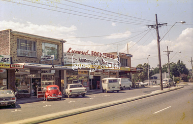
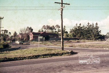
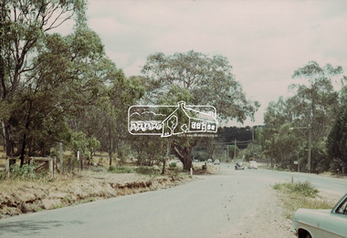
Photograph, Lower Plenty shops, Main Road, c.1976, 1976c
... Lower Plenty shops, Main Road, c.1976...lower plenty...shops...main road...Main Road, Lower Plenty, Victoria...Eltham District Historical Society Inc 728 Main Rd Eltham melbourne Streetscape development over time lower plenty shops main road shoe inn maunder's food store Agfa CNS Roll of 35mm colour negative film, 2 strips Lower Plenty shops, Main Road, c.1976 Photograph ...Streetscape development over timeRoll of 35mm colour negative film, 2 stripsAgfa CNSlower plenty, shops, main road, shoe inn, maunder's food store -
 Eltham District Historical Society Inc
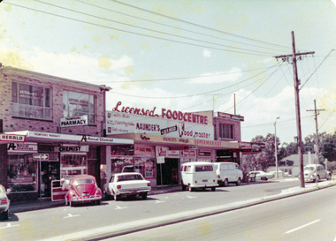
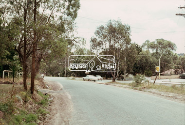
Photograph, Lower Plenty shops, Main Road, c.1976, 1976c
... Lower Plenty shops, Main Road, c.1976...lower plenty...shops...main road...Main Road, Lower Plenty, Victoria...Eltham District Historical Society Inc 728 Main Rd Eltham melbourne Streetscape development over time lower plenty shops main road Colour photograph Lower Plenty shops, Main Road, c.1976 Photograph ...Streetscape development over timeColour photographlower plenty, shops, main road -
 Eltham District Historical Society Inc
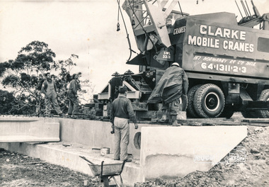
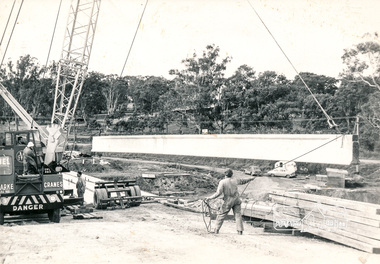
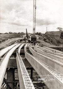
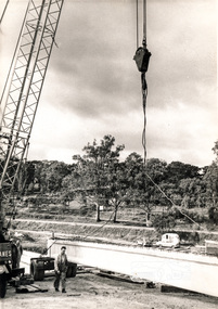
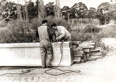
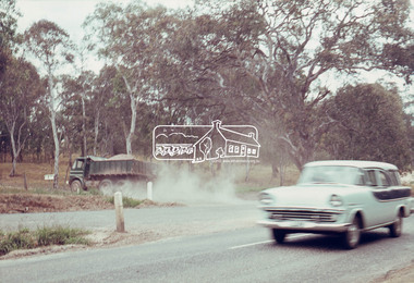
Photograph, Construction of Lower Plenty Bridge, Main Road, c.August 1966, 1966
... Construction of Lower Plenty Bridge, Main Road, c.August 1966...main road...lower plenty...Eltham District Historical Society Inc 728 Main Rd Eltham melbourne bridges bridge construction main road lower plenty plenty river cranes Black and white photograph of construction of northern Lower Plenty Bridge 1969 Construction of Lower Plenty Bridge, Main Road, c.August 1966 Photograph ...Black and white photograph of construction of northern Lower Plenty Bridge 1969bridges, bridge construction, main road, lower plenty, plenty river, cranes -
 Eltham District Historical Society Inc
Photograph, Construction of Lower Plenty Bridge, Main Road, c.August 1966, 1966
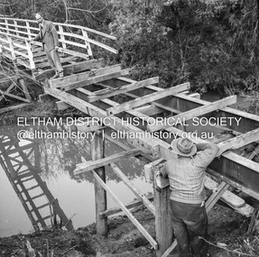
... Construction of Lower Plenty Bridge, Main Road, c.August 1966...plenty river...bridge construction...main road...lower...Construction activity of a new Main Road bridge over the Plenty River at Lower Plenty in 1966. ...The new bridge followed a realignment of the road and old Lower Plenty bridge remained in situ and is now part of the Plenty River Trail. plenty river bridge construction main road lower plenty bridges Black and white photograph of crane lowering concrete girder into place Construction of Lower Plenty Bridge, Main Road, c.August 1966 Photograph ...Construction activity of a new Main Road bridge over the Plenty River at Lower Plenty in 1966. The new bridge followed a realignment of the road and old Lower Plenty bridge remained in situ and is now part of the Plenty River Trail.Black and white photograph of crane lowering concrete girder into placeplenty river, bridge construction, main road, lower plenty, bridges -
 Eltham District Historical Society Inc
Photograph, Construction of Lower Plenty Bridge, Main Road, c.August 1966, 1966
... Construction of Lower Plenty Bridge, Main Road, c.August 1966...main road...plenty river...lower...Construction activity of a new Main Road bridge over the Plenty River at Lower Plenty in 1966. ...Construction of Lower Plenty Bridge, Main Road, c.August 1966 Photograph ...Construction activity of a new Main Road bridge over the Plenty River at Lower Plenty in 1966. The new bridge followed a realignment of the road and old Lower Plenty bridge remained in situ and is now part of the Plenty River Trail.Local significanceBlack and white photograph taken during construction of the Main Road bridge over the Plenty River. Includes structural members, construction personnel, vehicles and a Clarke mobile crane.mobile cranes, bridge construction, main road, plenty river, lower plenty, bridges -
 Eltham District Historical Society Inc
Photograph, Construction of Lower Plenty Bridge, Main Road, c.August 1966, 1966
... Construction of Lower Plenty Bridge, Main Road, c.August 1966...main road...lower plenty...Construction activity of a new Main Road bridge over the Plenty River at Lower Plenty in 1966. ...Black and white photograph of construction of new bridge, Main Road, Lower Plenty...The new bridge followed a realignment of the road and old Lower Plenty bridge remained in situ and is now part of the Plenty River Trail. bridge construction main road lower plenty plenty river bridges Black and white photograph of construction of new bridge, Main Road, Lower Plenty Construction of Lower Plenty Bridge, Main Road, c.August 1966 Photograph ...Construction activity of a new Main Road bridge over the Plenty River at Lower Plenty in 1966. The new bridge followed a realignment of the road and old Lower Plenty bridge remained in situ and is now part of the Plenty River Trail.Black and white photograph of construction of new bridge, Main Road, Lower Plentybridge construction, main road, lower plenty, plenty river, bridges -
 Eltham District Historical Society Inc
Negative - Photograph, J.A. McDonald, Eltham-Yarra Glen Road, Lower Plenty footbridge, Sep. 1955
... Road...Lower Plenty Footbridge...Lower Plenty...Lower Plenty Bridge...Lower Plenty Road...Main...Road as designated originated at the Shire of Eltham boundary at the Plenty River. West of the river the road was known as the Heidelberg-Eltham Road. The section from the Plenty River is now known as Lower Plenty Road which becomes Main Road. ...Eltham District Historical Society Inc 728 Main Rd Eltham melbourne The Eltham-Yarra Glen Road as designated originated at the Shire of Eltham boundary at the Plenty River. West of the river the road was known as the Heidelberg-Eltham Road. The section from the Plenty River is now known as Lower ...The Eltham-Yarra Glen Road as designated originated at the Shire of Eltham boundary at the Plenty River. West of the river the road was known as the Heidelberg-Eltham Road. The section from the Plenty River is now known as Lower Plenty Road which becomes Main Road. The footbridge no longer exists but was originally sited to the south, adjacent to the old Lower Plenty Bridge, now part of the Plenty River Trail. Record of various Shire of Eltham infrastructure works undertaken during the period of 1952-1962 involving bridge and road reconstruction projects, sometimes with Eltham Shire Council Project Reference numbers quoted. It was during this period that a number of significant improvements were made to roads and new bridges constructed within the shire that remain in place as of present day (2022). In many situations, the photos provide a tangible visible record of infrastructure that existed throughout the early days of the Shire. The album was put together by or under the direction of the Shire Engineer, J.A. McDonald.1955-09, eltham-yarra glen road, lower plenty footbridge, lower plenty, lower plenty bridge, lower plenty road, main road, plenty river trail, bridge construction, infrastructure, shire of eltham -
 Eltham District Historical Society Inc
Negative - Photograph, J.A. McDonald, Eltham-Yarra Glen Road, Lower Plenty footbridge, Sep. 1955
... Road...Lower Plenty Footbridge...J. Jolly...Lower Plenty...Lower Plenty Bridge...Lower Plenty Road...Main...Road as designated originated at the Shire of Eltham boundary at the Plenty River. West of the river the road was known as the Heidelberg-Eltham Road. The section from the Plenty River is now known as Lower Plenty Road which becomes Main Road. ...Main Rd Eltham melbourne Tony Carberry and J. Jolly The Eltham-Yarra Glen Road as designated originated at the Shire of Eltham boundary at the Plenty River. West of the river the road was known as the Heidelberg-Eltham Road. The section from the Plenty River is now known as Lower ...Tony Carberry and J. Jolly The Eltham-Yarra Glen Road as designated originated at the Shire of Eltham boundary at the Plenty River. West of the river the road was known as the Heidelberg-Eltham Road. The section from the Plenty River is now known as Lower Plenty Road which becomes Main Road. The footbridge no longer exists but was originally sited to the south, adjacent to the old Lower Plenty Bridge, now part of the Plenty River Trail. Record of various Shire of Eltham infrastructure works undertaken during the period of 1952-1962 involving bridge and road reconstruction projects, sometimes with Eltham Shire Council Project Reference numbers quoted. It was during this period that a number of significant improvements were made to roads and new bridges constructed within the shire that remain in place as of present day (2022). In many situations, the photos provide a tangible visible record of infrastructure that existed throughout the early days of the Shire. The album was put together by or under the direction of the Shire Engineer, J.A. McDonald.1955-09, eltham-yarra glen road, lower plenty footbridge, j. jolly, lower plenty, lower plenty bridge, lower plenty road, main road, plenty river trail, tony carberry, bridge construction, infrastructure, shire of eltham -
 Eltham District Historical Society Inc
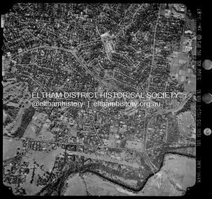
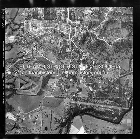
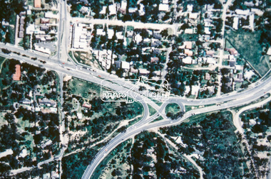
Photograph - Aerial Photograph, Landata, Montmorency / Lower Plenty, Mar. 1987
... ...Lower Plenty...Main Road...Centred on 354-356 Main Road, Lower Plenty bounded by Rattray Road, Montmorency to north, Yarra River to south, Falkiner Street, Eltham to east and Lower Plenty shops to west. ...Historic Aerial Imagery Source: Landata.vic.gov.au Aerial Photo Details: Project No :1716 Project : WESTERN PORT FORESHORES Run : 16 Frame : 132 Date : 03/1987 Film Type : B/W Camera : RC10 Flying Height : 5600 Scale : 10000 Film Number : 4102 GDA2020 : 37°43'51"S, 145°07'38"E MGA2020 : 334968, 5822406 (55) Melways : 21 E9 (ed. 42) Aerial Photo Lower Plenty Main Road Montmorency Phoebe Mason Collection Eltham Eltham Lower Park Falkiner Street Lower Plenty Shops Main Road Eltham Rattray Road Yarra River Electronic PDF file Montmorency / Lower Plenty Photograph Aerial Photograph Landata ...Centred on 354-356 Main Road, Lower Plenty bounded by Rattray Road, Montmorency to north, Yarra River to south, Falkiner Street, Eltham to east and Lower Plenty shops to west. Historic Aerial Imagery Source: Landata.vic.gov.au Aerial Photo Details: Project No :1716 Project : WESTERN PORT FORESHORES Run : 16 Frame : 132 Date : 03/1987 Film Type : B/W Camera : RC10 Flying Height : 5600 Scale : 10000 Film Number : 4102 GDA2020 : 37°43'51"S, 145°07'38"E MGA2020 : 334968, 5822406 (55) Melways : 21 E9 (ed. 42)aerial photo, lower plenty, main road, montmorency, phoebe mason collection, eltham, eltham lower park, falkiner street, lower plenty shops, main road eltham, rattray road, yarra river -
 Eltham District Historical Society Inc
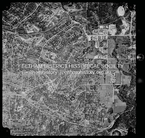
Photograph - Aerial Photograph, Landata, Montmorency, Vic, Apr. 1972
... ...Lower Plenty...Main Road...Main Road to south, Main Road to east and Alban Street to west. Historic Aerial Imagery Source: Landata.vic.gov.au Aerial Photo Details: Project No :985 Project : MELBOURNE 1972 Run : 28 Frame : 206 Date : 04/1972 Film Type : B/W Camera : RC10 Flying Height : 5700 Scale : 9600 Film Number : 2635 GDA2020 : 37°43'21"S, 145°07'46"E MGA2020 : 335154, 5823329 (55) Melways : 21 E7 (ed. 42) Aerial Photo Neil Webster Collection 1972-04 Eltham Alban Street Grand Boulevard Lower Plenty Main Road Melway 21E7 Meruka Drive Montmorency Olympic Avenue Digital jpg and electronic PDF file Montmorency, Vic. ...Centred on present day Olympic Avenue at Grand Boulevard, Montmorency bounded by Meruka Drive to north, Main Road to south, Main Road to east and Alban Street to west. Historic Aerial Imagery Source: Landata.vic.gov.au Aerial Photo Details: Project No :985 Project : MELBOURNE 1972 Run : 28 Frame : 206 Date : 04/1972 Film Type : B/W Camera : RC10 Flying Height : 5700 Scale : 9600 Film Number : 2635 GDA2020 : 37°43'21"S, 145°07'46"E MGA2020 : 335154, 5823329 (55) Melways : 21 E7 (ed. 42)aerial photo, neil webster collection, 1972-04, eltham, alban street, grand boulevard, lower plenty, main road, melway 21e7, meruka drive, montmorency, olympic avenue -
 Eltham District Historical Society Inc
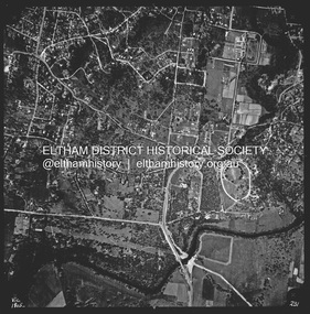
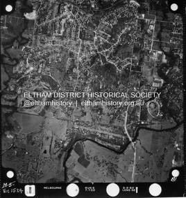
Photograph - Aerial Photograph, Landata, Lower Plenty, Vic, Apr. 1963
... ...Lower Plenty...Main Road...Centred on present day Old Eltham Road near Araluen Centre, Lower Plenty bounded by Cromwell Street to north, Yarra River to south, Main Road at Mount Pleasant Road to east and Panorama Avenue to west. ...Historic Aerial Imagery Source: Landata.vic.gov.au Aerial Photo Details: Project No :486 Project : MELBOURNE (1963) PROJECT Run : 7 Frame : 231 Date : 04/1963 Film Type : B/W Camera : RC8 Flying Height : 5100 Scale : 9600 Film Number : 1805 GDA2020 : 37°44'03"S, 145°07'56"E MGA2020 : 335420, 5822027 (55) Melways : 21 F10 (ed. 42) Aerial Photo Neil Webster Collection 1963-04 Araluen Cromwell Street Eltham Lower Plenty Main Road Melway 21F10 Mount Pleasant Road Old Eltham Road Panorama Avenue Yarra River Digital jpg and electronic PDF file Lower Plenty, Vic. ...Centred on present day Old Eltham Road near Araluen Centre, Lower Plenty bounded by Cromwell Street to north, Yarra River to south, Main Road at Mount Pleasant Road to east and Panorama Avenue to west. Historic Aerial Imagery Source: Landata.vic.gov.au Aerial Photo Details: Project No :486 Project : MELBOURNE (1963) PROJECT Run : 7 Frame : 231 Date : 04/1963 Film Type : B/W Camera : RC8 Flying Height : 5100 Scale : 9600 Film Number : 1805 GDA2020 : 37°44'03"S, 145°07'56"E MGA2020 : 335420, 5822027 (55) Melways : 21 F10 (ed. 42)aerial photo, neil webster collection, 1963-04, araluen, cromwell street, eltham, lower plenty, main road, melway 21f10, mount pleasant road, old eltham road, panorama avenue, yarra river -
 Eltham District Historical Society Inc
Photograph - Aerial Photograph, Landata, Montmorency / Lower Plenty, 28 Jan. 1946
... ...Lower Plenty...Main Road...Centred on 32 Grand Boulevard, Montmorency bounded by Rattray Road to north, Main Road, Lower Plenty to south, Bolton Street to east and Looker Road to west. ...Historic Aerial Imagery Source: Landata.vic.gov.au Aerial Photo Details: Project No :5 Project : MELBOURNE AND METROPOLITAN AREA PROJECT Run : 34 Frame : 61778 Date : 12/1945 (28.1.46) Film Type : B/W Camera : EAG4 Flying Height : 10200 Scale : 6000 Film Number : 212 GDA2020 : 37°43'30"S, 145°07'37"E MGA2020 : 334934, 5823043 (55) Melways : 21 E8 (ed. 42) Aerial Photo Bolton Steet Looker Road Lower Plenty Main Road Montmorency Phoebe Mason Collection Rattray Road Electronic PDF file Montmorency / Lower Plenty Photograph Aerial Photograph Landata ...Centred on 32 Grand Boulevard, Montmorency bounded by Rattray Road to north, Main Road, Lower Plenty to south, Bolton Street to east and Looker Road to west. Historic Aerial Imagery Source: Landata.vic.gov.au Aerial Photo Details: Project No :5 Project : MELBOURNE AND METROPOLITAN AREA PROJECT Run : 34 Frame : 61778 Date : 12/1945 (28.1.46) Film Type : B/W Camera : EAG4 Flying Height : 10200 Scale : 6000 Film Number : 212 GDA2020 : 37°43'30"S, 145°07'37"E MGA2020 : 334934, 5823043 (55) Melways : 21 E8 (ed. 42)aerial photo, bolton steet, looker road, lower plenty, main road, montmorency, phoebe mason collection, rattray road -
 Eltham District Historical Society Inc
Photograph - Aerial Photograph, Landata, Montmorency / Lower Plenty, Feb. 1956
... ...Lower Plenty...Main Road...Historic Aerial Imagery Source: Landata.vic.gov.au Aerial Photo Details: Project No : 250 Project : MELBOURNE OUTER SUBURBS PROJECT Run : 16A Frame : 53 Date : 02/1956 Film Type : B/W Camera : EAG9 Flying Height : 10000 Scale : 12000 Film Number : 1187 GDA2020 : 37°43'47"S, 145°07'25"E MGA2020 : 334645, 5822519 (55) Melways : 21 D9 (ed. 42) Aerial Photo Lower Plenty Main Road Montmorency Phoebe Mason Collection Bolton Steet Heidelberg Golf Club Rattray Road Electronic PDF file Montmorency / Lower Plenty Photograph Aerial Photograph Landata ...Centred on 20 Panorama Avenue, Lower Plenty bounded by Rattray Road to north, Yarra River to south, Bolton Street to east and Heidelberg Golf Club to west. Historic Aerial Imagery Source: Landata.vic.gov.au Aerial Photo Details: Project No : 250 Project : MELBOURNE OUTER SUBURBS PROJECT Run : 16A Frame : 53 Date : 02/1956 Film Type : B/W Camera : EAG9 Flying Height : 10000 Scale : 12000 Film Number : 1187 GDA2020 : 37°43'47"S, 145°07'25"E MGA2020 : 334645, 5822519 (55) Melways : 21 D9 (ed. 42)aerial photo, lower plenty, main road, montmorency, phoebe mason collection, bolton steet, heidelberg golf club, rattray road -
 Eltham District Historical Society Inc
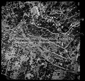
Photograph - Aerial Photograph, Landata, Montmorency / Lower Plenty, Jan. 1962
... ...Lower Plenty...Main Road...Centred on 147 Old Eltham Road, Lower Plenty bounded by Hurstbridge Railway Line to north, Yarra River to south, Main Road, Eltham to east and Heidelberg Golf Club to west. ...Historic Aerial Imagery Source: Landata.vic.gov.au Aerial Photo Details: Project No : 539 Project : MELBOURNE-GEELONG PROJECT Run : 6 Frame : 81 Date : 01/1962 Film Type : B/W Camera : RC5 Flying Height : 6000 Scale : 15840 Film Number : 1524 GDA2020 : 37°43'52"S, 145°07'26"E MGA2020 : 334685, 5822354 (55) Melways : 21 D9 (ed. 42) Aerial Photo Lower Plenty Main Road Montmorency Phoebe Mason Collection Eltham Eltham Lower Park Heidelberg Golf Club Hurstbridge Railway Line Main Road Eltham Yarra River Electronic PDF file Montmorency / Lower Plenty Photograph Aerial Photograph Landata ...Centred on 147 Old Eltham Road, Lower Plenty bounded by Hurstbridge Railway Line to north, Yarra River to south, Main Road, Eltham to east and Heidelberg Golf Club to west. Historic Aerial Imagery Source: Landata.vic.gov.au Aerial Photo Details: Project No : 539 Project : MELBOURNE-GEELONG PROJECT Run : 6 Frame : 81 Date : 01/1962 Film Type : B/W Camera : RC5 Flying Height : 6000 Scale : 15840 Film Number : 1524 GDA2020 : 37°43'52"S, 145°07'26"E MGA2020 : 334685, 5822354 (55) Melways : 21 D9 (ed. 42)aerial photo, lower plenty, main road, montmorency, phoebe mason collection, eltham, eltham lower park, heidelberg golf club, hurstbridge railway line, main road eltham, yarra river -
 Eltham District Historical Society Inc
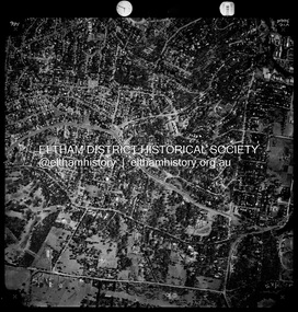
Photograph - Aerial Photograph, Landata, Montmorency / Lower Plenty, Jan. 1973
... ...Lower Plenty...Main Road...Centred on 385 Main Road, Lower Plenty bounded by Grand Boulevard, Montmorency to north, Old Eltham Road to south, Bolton Street to east and Panorama Avenue to west. ...Historic Aerial Imagery Source: Landata.vic.gov.au Aerial Photo Details: Project No :1043 Project : MONTMORENCY Run : 2 Frame : 124 Date : 01/1973 Film Type : B/W Camera : RC8 Flying Height : 2200 Scale : 4000 Film Number : 2722 GDA2020 : 37°43'48"S, 145°07'49"E MGA2020 : 335243, 5822507 (55) Melways : 21 E9 (ed. 42) Aerial Photo Lower Plenty Main Road Montmorency Phoebe Mason Collection Bolton Steet Grand Boulevard Old Eltham Road Panorama Avenue Electronic PDF file Montmorency / Lower Plenty Photograph Aerial Photograph Landata ...Centred on 385 Main Road, Lower Plenty bounded by Grand Boulevard, Montmorency to north, Old Eltham Road to south, Bolton Street to east and Panorama Avenue to west. Historic Aerial Imagery Source: Landata.vic.gov.au Aerial Photo Details: Project No :1043 Project : MONTMORENCY Run : 2 Frame : 124 Date : 01/1973 Film Type : B/W Camera : RC8 Flying Height : 2200 Scale : 4000 Film Number : 2722 GDA2020 : 37°43'48"S, 145°07'49"E MGA2020 : 335243, 5822507 (55) Melways : 21 E9 (ed. 42)aerial photo, lower plenty, main road, montmorency, phoebe mason collection, bolton steet, grand boulevard, old eltham road, panorama avenue -
 Eltham District Historical Society Inc
Photograph - Aerial Photograph, Landata, Montmorency / Lower Plenty, Nov. 1975
... ...Lower Plenty...Main Road...Centred on 328 Main Road, Lower Plenty bounded by Rattray Road, Montmorency to north, Rosehill Road to south, Falkiner Street to east and Lower Plenty shops to west. ...Eltham District Historical Society Inc 728 Main Rd Eltham melbourne Centred on 328 Main Road, Lower Plenty bounded by Rattray Road, Montmorency to north, Rosehill Road to south, Falkiner Street to east and Lower Plenty shops to west. ...Centred on 328 Main Road, Lower Plenty bounded by Rattray Road, Montmorency to north, Rosehill Road to south, Falkiner Street to east and Lower Plenty shops to west. Historic Aerial Imagery Source: Landata.vic.gov.au Aerial Photo Details: Project No :1243 Project : (ALSO A.P. 1227) Run : 24A Frame : 146 Date : 11/1975 Film Type : B/W Camera : RC8 Flying Height : 5000 Scale : 10000 Film Number : 2722 GDA2020 : 37°43'40"S, 145°07'32"E MGA2020 : 334820, 5822743 (55) Melways : 21 D8 (ed. 42)aerial photo, lower plenty, main road, montmorency, phoebe mason collection, eltham lower park, falkiner street, lower plenty shops, rattray road, rosehill road -
 Eltham District Historical Society Inc
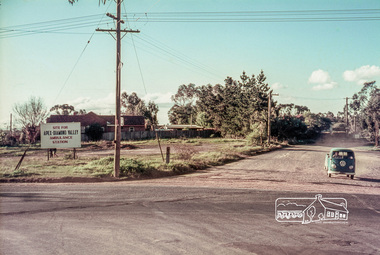
Slide, Site for the new Apex-Diamond Valley Ambulance Station, corner of Main Road and Looker Road, Montmorency, July 1969, 1969
... 1969-07, ambulance station, apex way, apex-diamond valley ambulance station, eltham ambulance station, looker road, lower plenty, main road, montmorency, Eltham Apex Club...Main Road towards Looker Road at the new site for the Apex-Diamond Valley Ambulance Station before construction of Apex Way, July 1969. The Eltham Apex Club conducted a Community Service Project (1965-1968) to raise funds for a new Ambulance Station to service the community. A site bounded by the intersection of Main Road, Grand Boulevard and Looker Road at Montmorency was purchased in 1969. In 1970, Eltham Shire Council undertook roadworks to construct Apex Way in preparation for the new station as well as duplicate Main Road, Lower Plenty..., east of Grand Boulevard including the new Lower Plenty Bridge, which had been opened in November 1966, bordering with the City of Heidelberg. 1969-07, ambulance station, apex way, apex-diamond valley ambulance station, eltham ambulance station, looker road, lower plenty, main road, montmorency, Eltham Apex Club 35 mm colour positive transparency Mount - Agfacolor Service (Blue) Site for the new Apex-Diamond Valley Ambulance Station, corner of Main Road and Looker Road, Montmorency, July 1969 Slide ...Looking northwest from Main Road towards Looker Road at the new site for the Apex-Diamond Valley Ambulance Station before construction of Apex Way, July 1969. The Eltham Apex Club conducted a Community Service Project (1965-1968) to raise funds for a new Ambulance Station to service the community. A site bounded by the intersection of Main Road, Grand Boulevard and Looker Road at Montmorency was purchased in 1969. In 1970, Eltham Shire Council undertook roadworks to construct Apex Way in preparation for the new station as well as duplicate Main Road, Lower Plenty, east of Grand Boulevard including the new Lower Plenty Bridge, which had been opened in November 1966, bordering with the City of Heidelberg.35 mm colour positive transparency Mount - Agfacolor Service (Blue)1969-07, ambulance station, apex way, apex-diamond valley ambulance station, eltham ambulance station, looker road, lower plenty, main road, montmorency, eltham apex club -
 Eltham District Historical Society Inc
Slide, Site for the new Apex-Diamond Valley Ambulance Station, corner of Main Road and Grand Boulevard, Montmorency, July 1969, 1969
... 1969-07, ambulance station, apex way, grand boulevard, lower plenty, main road, montmorency, eltham ambulance station, apex-diamond valley ambulance station, Eltham Apex Club...Main Road and Panorama Avenue, Montmorency showing the site for the new Apex-Diamond Valley Ambulance Station and before construction of Apex Way, July 1969. The Eltham Apex Club conducted a Community Service Project (1965-1968) to raise funds for a new Ambulance Station to service the community. A site bounded by the intersection of Main Road, Grand Boulevard and Looker Road at Montmorency was purchased in 1969. In 1970, Eltham Shire Council undertook roadworks to construct Apex Way in preparation for the new station as well as duplicate Main Road, Lower Plenty..., east of Grand Boulevard including the new Lower Plenty Bridge, which had been opened in November 1966, bordering with the City of Heidelberg. 1969-07, ambulance station, apex way, grand boulevard, lower plenty, main road, montmorency, eltham ambulance station, apex-diamond valley ambulance station, Eltham Apex Club 35 mm colour positive transparency Mount - Agfacolor Service (Blue) Site for the new Apex-Diamond Valley Ambulance Station, corner of Main Road and Grand Boulevard, Montmorency, July 1969 Slide ...View looking west along Grand Boulevard from the intersection with Main Road and Panorama Avenue, Montmorency showing the site for the new Apex-Diamond Valley Ambulance Station and before construction of Apex Way, July 1969. The Eltham Apex Club conducted a Community Service Project (1965-1968) to raise funds for a new Ambulance Station to service the community. A site bounded by the intersection of Main Road, Grand Boulevard and Looker Road at Montmorency was purchased in 1969. In 1970, Eltham Shire Council undertook roadworks to construct Apex Way in preparation for the new station as well as duplicate Main Road, Lower Plenty, east of Grand Boulevard including the new Lower Plenty Bridge, which had been opened in November 1966, bordering with the City of Heidelberg.35 mm colour positive transparency Mount - Agfacolor Service (Blue)1969-07, ambulance station, apex way, grand boulevard, lower plenty, main road, montmorency, eltham ambulance station, apex-diamond valley ambulance station, eltham apex club -
 Eltham District Historical Society Inc
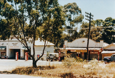
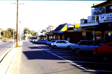
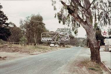
Photograph, Lower Plenty shops and garage
... ...lower plenty...main road...Eltham District Historical Society Inc 728 Main Rd Eltham melbourne shops service station lower plenty main road Colour photograph of old shops and service station Lower Plenty (prior to construction of present shopping centre). 4 x 6 print and 8 x 10 laminated print Lower Plenty shops and garage Photograph ...Colour photograph of old shops and service station Lower Plenty (prior to construction of present shopping centre). 4 x 6 print and 8 x 10 laminated printshops, service station, lower plenty, main road -
 Greensborough Historical Society
Photograph - Photograph (Copy), Anne Paul, Lot 2A Main Road Lower Plenty, 2007_05
... Lot 2A Main Road Lower Plenty...lower plenty...main road...Three views of entry into Lot 2A Main Road Lower Plenty, now Edward Willis Drive....Greensborough Historical Society 34A Glenauburn Road Lower Plenty Lower Plenty melbourne Three views of entry into Lot 2A Main Road Lower Plenty, now Edward Willis Drive. lower plenty main road lower plenty edward willis drive lower plenty 3 colour photographs printed on paper, handwritten captions Lot 2A Main Road Lower Plenty Photograph Photograph (Copy) Anne Paul ...Three views of entry into Lot 2A Main Road Lower Plenty, now Edward Willis Drive.3 colour photographs printed on paper, handwritten captionslower plenty, main road lower plenty, edward willis drive lower plenty -
 Greensborough Historical Society
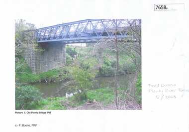
Photograph - Photograph (Copy), Anne Paul, Old Plenty Bridge Lower Plenty, 2003_05
... lower plenty...main road...Various views of entry into Lot 2A Main Road Lower Plenty, now Edward Willis Drive, including the old Plenty River Bridge....Greensborough Historical Society 34A Glenauburn Road Lower Plenty Lower Plenty melbourne Various views of entry into Lot 2A Main Road Lower Plenty, now Edward Willis Drive, including the old Plenty River Bridge. lower plenty main road lower plenty edward willis drive lower plenty plenty river bridge plenty river forum 3 colour photographs printed on paper, handwritten or typed captions Old Plenty Bridge Lower Plenty Photograph Photograph (Copy) Anne Paul Fred Buono ...Various views of entry into Lot 2A Main Road Lower Plenty, now Edward Willis Drive, including the old Plenty River Bridge.3 colour photographs printed on paper, handwritten or typed captionslower plenty, main road lower plenty, edward willis drive lower plenty, plenty river bridge, plenty river forum -
 Greensborough Historical Society
Slide - Photograph, John Ramsdale, Main Road shops, Lower Plenty: Slide 70, 1990s
... Main Road shops, Lower Plenty: Slide 70...Lower Plenty...main road...Photograph shows a shopping centre - Main Road Lower Plenty...Lower Plenty main road lower plenty No maker's marks. ...Photograph shows a shopping centre - Main Road Lower PlentyPart of the John Ramsdale collection of slides and audio visual material.Colour photograph scanned from slide.No maker's marks. No caption on slide.lower plenty, main road lower plenty -
 Greensborough Historical Society
Photograph - Digital Image, Lower Plenty and Yallambie Roads Lower Plenty 1974, 1974_
... lower plenty...yallambie road lower plenty...main...Road Lower Plenty Lower Plenty melbourne Lower Plenty 1974. This photograph shows the corner of Lower Plenty Road and Yallambie Road Lower Plenty in 1974. This road is now controlled by traffic lights and Lower Plenty Road is duplicated. lower plenty yallambie road lower plenty main road lower plenty lower plenty road lower plenty Digital copy of black and white photograph Lower Plenty and Yallambie Roads Lower Plenty 1974 Photograph - Digital Image ...Lower Plenty 1974. This photograph shows the corner of Lower Plenty Road and Yallambie Road Lower Plenty in 1974. This road is now controlled by traffic lights and Lower Plenty Road is duplicated.Digital copy of black and white photographlower plenty, yallambie road lower plenty, main road lower plenty, lower plenty road lower plenty -
 Eltham District Historical Society Inc
Album - Photograph Album, J.A. McDonald, Bridge and Road Reconstruction Works, Shire of Eltham, 1952-1962
... Road...Long Gully...Lower Plenty Bridge...Lower Plenty Footbridge...Lower Plenty Oval...Lower Plenty Road...Lower Plenty...Main...Jolly Kangaroo Ground Kangaroo Ground-Queenstown Road Kangaroo Ground-St Andrews Road Lilydale Shire Office Long Gully Bridge Long Gully Creek Long Gully Road Long Gully Lower Plenty Bridge Lower Plenty Footbridge Lower Plenty Oval Lower Plenty Road Lower Plenty Main Road Methodist Church Montmorency Mount Pleasant Road New Holland Old Healesville Road Opening Ceremony Oxley Bridge Para Road Paul Creek Bridge Paul Creek Road Paul Krafeznk Pinnacle Lane Plaques Plenty River Trail Plenty River Presbyterian Church Prof Donald Thomson Pryor Street railway crossing Railway Parade Rattray Road Reconstruction works Reichelt Avenue Research (Vic.) ...J.A. McDonald produced this record in the course of his responsibilities as Shire Engineer for Eltham Shire Council.Record of various Shire of Eltham infrastructure works undertaken during the period of 1952-1962 involving bridge and road reconstruction projects, sometimes with Eltham Shire Council Project Reference numbers quoted. It was during this period that a number of significant improvements were made to roads and new bridges constructed within the shire that remain in place as of present day (2022). In many situations, the photos provide a tangible visible record of infrastructure that existed throughout the early days of the Shire. The album was put together by or under the direction of the Shire Engineer, J.A. McDonald.a. gillies, alistair knox park, benchmark studies, bend of islands, blease road, box hill state school, box hill teachers college, box hill tip, bridge construction, bridge street bridge, bridge, brisbane street, brougham steet, bulldozer, cecil street, charis pelling, cherry tree road, city of preston, cr. a. brinkkotter, cr. charis pelling, cranes, cromwell street, diamond creek (creek), diamond street, dixons creek bridge, dixon's creek road, drott, eltham leisure centre, eltham north, eltham police station, eltham, eltham-yarra glen road, f. wood, fitzsimons lane bridge, flat rock road, flood damage, floods, floodwater, footpaths and gutters, ford service garage, g. blair, garden hill, glen park bridge, glenauburn road, grand hotel, haldane road, healesville, healesville-yarra glen road, heidelberg-kinglake road, henley road bridge, henley road, hill property, hurstbridge water scheme, hurstbridge, hurstbridge-arthurs creek road, infrastructure, j. jolly, kangaroo ground, kangaroo ground-queenstown road, kangaroo ground-st andrews road, lilydale shire office, long gully bridge, long gully creek, long gully road, long gully, lower plenty bridge, lower plenty footbridge, lower plenty oval, lower plenty road, lower plenty, main road, methodist church, montmorency, mount pleasant road, new holland, old healesville road, opening ceremony, oxley bridge, para road, paul creek bridge, paul creek road, paul krafeznk, pinnacle lane, plaques, plenty river trail, plenty river, presbyterian church, prof donald thomson, pryor street, railway crossing, railway parade, rattray road, reconstruction works, reichelt avenue, research (vic.), research oval, road construction, rymers corner, shire of eltham, shire of whittlesea, silvan road bridge, silver street bridge, silver street, sir dallas brooks, smedley property, st andrews, steels creek, susan street, tarrawarra, tony carberry, uniting church, upper yarra dam, upper yarra reservoir, w.e. wolf, waterfall property, watsons creek, wattletree road bridge, wattletree road, wattletree road bridge, worlingworth, yarra glen, york street, yow yow creek -
 Eltham District Historical Society Inc
Slide - Photograph, Aerial Photo (c.1987): Main Road, Fitzsimons Lane, Lower Plenty, c.Aug. 1990
... Aerial Photo (c.1987): Main Road, Fitzsimons Lane, Lower Plenty......Lower Plenty...Main Road...roads of Kinglake. In the byways category are views of some iof the Shire's bicycle paths including then recently completed sections of the Main Yarra Trail at Lower Plenty..... infrastructure roads aerial photographs Roundabout Bolton Steet Bolton Steet Shops Eltham Fitzsimons Lane Lower Plenty Main Road 35mm colour positive transparency (1 of 37) Mount - Agfachrome Agfa CS System black 8 dots Aerial Photo (c.1987): Main Road, Fitzsimons Lane, Lower Plenty Slide Photograph ...Part of a presentation, "Roads and Byways of the Shire of Eltham", by Russell Yeoman to the 12 September 1990 Society meeting. Slides shown included copies of old photos and recent images ranging from the suburban streets of Eltham and Montmorency to the mountain roads of Kinglake. In the byways category are views of some iof the Shire's bicycle paths including then recently completed sections of the Main Yarra Trail at Lower Plenty.35mm colour positive transparency (1 of 37) Mount - Agfachrome Agfa CS System black 8 dotsinfrastructure, roads, aerial photographs, roundabout, bolton steet, bolton steet shops, eltham, fitzsimons lane, lower plenty, main road -
 Eltham District Historical Society Inc
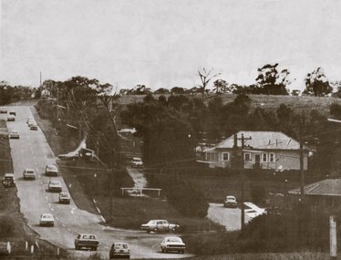
Photograph, Looking west along Old Eltham Road towards intersection with Main Road, Lower Plenty, 1968, 1968
... Looking west along Old Eltham Road towards intersection with Main Road, Lower Plenty, 1968...Lower Plenty, Main Road, Old Eltham Road...Eltham District Historical Society Inc 728 Main Rd Eltham melbourne Lower Plenty, Main Road, Old Eltham Road 35mm Colour positive transparency Mount - Agfacolor Service (Blue stepped) Looking west along Old Eltham Road towards intersection with Main Road, Lower Plenty, 1968 Photograph ...35mm Colour positive transparency Mount - Agfacolor Service (Blue stepped)lower plenty, main road, old eltham road -
 Eltham District Historical Society Inc
Photograph, Looking west along Old Eltham Road towards intersection with Main Road, Lower Plenty, 1968, 1968
... Looking west along Old Eltham Road towards intersection with Main Road, Lower Plenty, 1968...lower plenty, main road, old eltham road...Eltham District Historical Society Inc 728 Main Rd Eltham melbourne lower plenty, main road, old eltham road 35mm Colour positive transparency Mount - Agfacolor Service (Blue stepped) Looking west along Old Eltham Road towards intersection with Main Road, Lower Plenty, 1968 Photograph ...35mm Colour positive transparency Mount - Agfacolor Service (Blue stepped)lower plenty, main road, old eltham road -
 Eltham District Historical Society Inc
Photograph, Looking southwest along Main Road near intersection of Old Eltham Road, Lower Plenty, 1968, 1968
... Looking southwest along Main Road near intersection of Old Eltham Road, Lower Plenty, 1968...Caltex Service Station, Lower Plenty, Main Road, Old Eltham Road...Main Road, Lower Plenty, Victoria, Australia...Eltham District Historical Society Inc 728 Main Rd Eltham melbourne Caltex Service Station, Lower Plenty, Main Road, Old Eltham Road 35mm Colour positive transparency Mount - Agfacolor Service (Blue stepped) Looking southwest along Main Road near intersection of Old Eltham Road, Lower Plenty, 1968 Photograph ...35mm Colour positive transparency Mount - Agfacolor Service (Blue stepped)caltex service station, lower plenty, main road, old eltham road -
 Eltham District Historical Society Inc
Photograph, Looking south across Main Road towards intersection with Old Eltham Road, Lower Plenty, 1968, 1968
... Looking south across Main Road towards intersection with Old Eltham Road, Lower Plenty, 1968...lower plenty, main road, old eltham road...Main Road, Lower Plenty, Victoria, Australia...Eltham District Historical Society Inc 728 Main Rd Eltham melbourne lower plenty, main road, old eltham road 35mm Colour positive transparency Mount - Agfacolor Service (Blue stepped) Looking south across Main Road towards intersection with Old Eltham Road, Lower Plenty, 1968 Photograph ...35mm Colour positive transparency Mount - Agfacolor Service (Blue stepped)lower plenty, main road, old eltham road