Showing 44 items matching "maddingley"
-
 Ballarat Heritage Services
Photograph - Digital photographs, L.J. Gervasoni, CSR Timbrock Factory Maddingley - internal remains of boiler, 2015
... CSR Timbrock Factory Maddingley - internal remains of boiler......maddingley...CSR Timbrock Factory Maddingley - internal remains of boiler...25 Rowsley Station Road, Maddingley, Hepburn Shire, Victoria, Australia...Ballarat Heritage Services PO Box 2209 Bakery Hill Post Office goldfields http://vhd.heritagecouncil.vic.gov.au/places/69285 jbd timbrock rowsley station maddingley factory csr jack mcconnell heritage industry industrial machinery CSR Timbrock Factory Maddingley - internal remains of boiler CSR Timbrock Factory Maddingley - internal remains of boiler Photograph Digital photographs L.J. ...http://vhd.heritagecouncil.vic.gov.au/places/69285 CSR Timbrock Factory Maddingley - internal remains of boilerjbd, timbrock, rowsley station, maddingley, factory, csr, jack mcconnell, heritage, industry, industrial, machinery -
 Ballarat Heritage Services
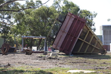
Photograph - Digital photographs, L.J. Gervasoni, Boiler House CSR Timbrock Factory Maddingley post demolition, 2016
... Boiler House CSR Timbrock Factory Maddingley post demolition......maddingley...Boiler House CSR Timbrock Factory Maddingley post demolition...25 Rowsley Station Road, Maddingley, Hepburn Shire, Victoria, Australia...Ballarat Heritage Services PO Box 2209 Bakery Hill Post Office goldfields http://vhd.heritagecouncil.vic.gov.au/places/69285 jbd timbrock rowsley station maddingley factory csr jack mcconnell heritage boiler house industry industrial demolition Boiler House CSR Timbrock Factory Maddingley post demolition Boiler House CSR Timbrock Factory Maddingley post demolition Photograph Digital photographs L.J. ...http://vhd.heritagecouncil.vic.gov.au/places/69285 Boiler House CSR Timbrock Factory Maddingley post demolitionjbd, timbrock, rowsley station, maddingley, factory, csr, jack mcconnell, heritage, boiler, house, industry, industrial, demolition -
 Ballarat Heritage Services
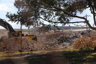
Digital photographs, L.J. Gervasoni, Boiler House CSR Timbrock Factory Maddingley Prior to Demolition, 2012, 2012
... Boiler House CSR Timbrock Factory Maddingley Prior to Demolition, 2012......maddingley...Digital images of the csr Boiler House Timbrock Factory at Maddingley prior to demolition....25 Rowsley Station Road, Maddingley, Hepburn Shire, Victoria, Australia...Ballarat Heritage Services PO Box 2209 Bakery Hill Post Office goldfields http://vhd.heritagecouncil.vic.gov.au/places/69285 jbd timbrock rowsley station maddingley factory csr jack mcconnell heritage boiler house industry industrial Digital images of the csr Boiler House Timbrock Factory at Maddingley prior to demolition. ...http://vhd.heritagecouncil.vic.gov.au/places/69285 Digital images of the csr Boiler House Timbrock Factory at Maddingley prior to demolition.jbd, timbrock, rowsley station, maddingley, factory, csr, jack mcconnell, heritage, boiler, house, industry, industrial -
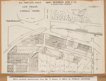
 Bacchus Marsh & District Historical Society
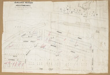
Map, Gaynor Street Area Land Sales, Maddingley, 1888
... Gaynor Street Area Land Sales, Maddingley, 1888....This map was produced for a major sale of land in the Maddingley area of Bacchus Marsh in 1888. The sale was conducted by two firms from Melbourne, Carney and Kelly 12 Swanston Street Melbourne. and 'Richardson, Kerr & Co. 40 Flinders Lane Melbourne. 136 blocks were for sale....A single page paper map showing land allotments for sale in the Maddingley area of Bacchus Marsh. Locations shown include Gaynor Street, Maddingley Road South, Parwan Road, Mitchem Street, Typpynge Street, Finn Street and East Maddingley Road. . ...Bacchus Marsh Victoria Maps Maddingley Victoria Maps Land Use Maddingley Victoria History Land Sales Bacchus Marsh Land Sales Maddingley A single page paper map showing land allotments for sale in the Maddingley area of Bacchus Marsh. ...This map was produced for a major sale of land in the Maddingley area of Bacchus Marsh in 1888. The sale was conducted by two firms from Melbourne, Carney and Kelly 12 Swanston Street Melbourne. and 'Richardson, Kerr & Co. 40 Flinders Lane Melbourne. 136 blocks were for sale.A single page paper map showing land allotments for sale in the Maddingley area of Bacchus Marsh. Locations shown include Gaynor Street, Maddingley Road South, Parwan Road, Mitchem Street, Typpynge Street, Finn Street and East Maddingley Road. . The map is pasted into a bound volume containing 76 maps or plans in total. High resolution digital image stored on BMDHS computer network. bacchus marsh victoria maps, maddingley victoria maps, land use, maddingley victoria history, land sales bacchus marsh, land sales maddingley -
 Bacchus Marsh & District Historical Society
Map, Gaynor Street Land Sales, Maddingley, circa 1880s-1890s
... Gaynor Street Land Sales, Maddingley, circa 1880s-1890s...This map was produced for a major sale of land in the Maddingley area of Bacchus Marsh. The precise date of the sale has not been determined. ...A single page paper map showing land allotments for sale in the Maddingley area of Bacchus Marsh. Locations shown include Gaynor Street, Maddingley Road South, Parwan Road, Mitchem Street, Typpynge Street, Finn Street and East Maddingley Road. . ...Bacchus Marsh Victoria Maps Maddingley Victoria Maps Land Use Maddingley Victoria History Land Sales Bacchus Marsh Land Sales Maddingley A single page paper map showing land allotments for sale in the Maddingley area of Bacchus Marsh. ...This map was produced for a major sale of land in the Maddingley area of Bacchus Marsh. The precise date of the sale has not been determined. Features present on the map such as the Bacchus Marsh Railway Station indicate the land sale must have taken place some time after 1887 when the Railway Station opened. A single page paper map showing land allotments for sale in the Maddingley area of Bacchus Marsh. Locations shown include Gaynor Street, Maddingley Road South, Parwan Road, Mitchem Street, Typpynge Street, Finn Street and East Maddingley Road. . The map is pasted into a bound volume containing 76 maps or plans in total. High resolution digital image stored on BMDHS computer network. bacchus marsh victoria maps, maddingley victoria maps, land use, maddingley victoria history, land sales bacchus marsh, land sales maddingley -
 Ballarat Heritage Services
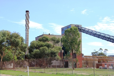
Digital photographs, L.J. Gervasoni, CSR Timbrock Factory Maddingley - Jack McConnell Architect, 2015
... CSR Timbrock Factory Maddingley - Jack McConnell Architect......maddingley...25 Rowsley Station Road, Maddingley, Hepburn Shire, Victoria, Australia...Ballarat Heritage Services PO Box 2209 Bakery Hill Post Office goldfields http://vhd.heritagecouncil.vic.gov.au/places/69285 jbd timbrock rowsley station maddingley factory csr jack mcconnell heritage industry industrial glass curtain wall modern Digital images CSR Timbrock Factory Maddingley - Jack McConnell Architect Digital photographs L.J. ...http://vhd.heritagecouncil.vic.gov.au/places/69285 Digital imagesjbd, timbrock, rowsley station, maddingley, factory, csr, jack mcconnell, heritage, industry, industrial, glass, curtain, wall, modern -
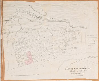 Bacchus Marsh & District Historical Society
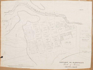
Map, Maddingley Township, Parish of Parwan, circa 1890s
... Maddingley Township, Parish of Parwan, circa 1890s...Maddingley is a locality or township within the broader township area of Bacchus Marsh. ...A single page paper map showing land allotments, streets, rivers, creeks, park lands, the railway line and Bacchus Marsh railway station in the township of Maddingley. The map is pasted into a bound volume containing 76 maps or plans in total. ...The main residential and commercial area of Maddingley is shown on this map in an area bounded by Bacchus Street, Barry Street, Griffith Street and Maddingley Road. ...Maddingley is a locality or township within the broader township area of Bacchus Marsh. This map is not dated. However features in Maddingley which appeared in the 1880s and 1890s are present in the map, These include the Bacchus Marsh Railway Station and the Bacchus Marsh Showgrounds. The main residential and commercial area of Maddingley is shown on this map in an area bounded by Bacchus Street, Barry Street, Griffith Street and Maddingley Road. Other streets visible are Franklin Street, Inglis Street, Labilliere Street, McCrae Street, Moore Street and part of Station Street.A single page paper map showing land allotments, streets, rivers, creeks, park lands, the railway line and Bacchus Marsh railway station in the township of Maddingley. The map is pasted into a bound volume containing 76 maps or plans in total. bacchus marsh victoria maps, maddingley victoria maps, land use, maddingley victoria history -
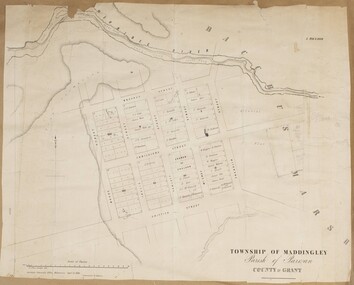 Bacchus Marsh & District Historical Society
Map, Maddingley Township, Parish of Parwan, County of Grant, 1856
... Maddingley Township, Parish of Parwan, County of Grant, 1856...Maddingley is a locality or township within the broader township area of Bacchus Marsh. ...A single page paper map showing land allotments, streets, and natural watercourses in the township of Maddingley. The map is pasted into a bound volume containing 76 maps or plans in total. ...Bacchus Marsh Victoria Maps Maddingley Victoria Maps Land Use Maddingley Victoria History Two inscriptions: 1. ...Maddingley is a locality or township within the broader township area of Bacchus Marsh. This map is dated 1856 but is based on an earlier survey in 1843. The main area of Maddingley shown on this map is an area bounded by Bacchus Street, Moore Street, Griffith Street and Franklin Street. Other streets visible are Inglis Street, Labilliere Street, McCrae Street. The area to the east of Franklin Street is not sub-divided and is described as an 'alluvial flat. A single page paper map showing land allotments, streets, and natural watercourses in the township of Maddingley. The map is pasted into a bound volume containing 76 maps or plans in total. Two inscriptions: 1. A.J. Skene Surveyor, 1843. ; 2. Surveyor-General's Office Melbourne, Sept 6, 1856. (Lithographed by R. Meikle)bacchus marsh victoria maps, maddingley victoria maps, land use, maddingley victoria history -
 Bacchus Marsh & District Historical Society
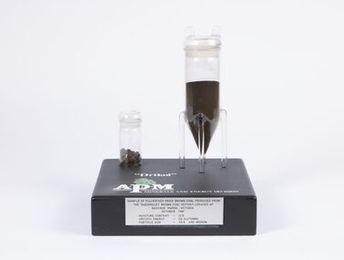
Geological specimen - Sample of Pulverised Dried Brown Coal, Maddingley Brown Coal Mine, 1981
... The Maddingley area of Bacchus Marsh was surveyed for brown coal deposits in the 1930s. ...Sample of pulverised brown coal produced from Maddingley brown coal deposit located at Bacchus Marsh Victoria, October 1981. ...Maddingley Brown Coal Mine...Coal Mines Mining Brown Coal Maddingley Brown Coal Mine Sample of pulverised brown coal produced from Maddingley brown coal deposit located at Bacchus Marsh Victoria, October 1981. ...The Maddingley area of Bacchus Marsh was surveyed for brown coal deposits in the 1930s. By the early 1940s brown coal in large quantities was being extracted and was transported to Melbourne where it was used to fire boilers for the Australian Paper Mills (APM) company. By the 1970s APM was using natural gas instead of coal. Maddingley brown coal was then used to fire boilers for the CRA/VISY cardboard factory at Bacchus Marsh. This factory closed down in 1990. During the 1990s the mine was acquired by the Calleja family company who ran transport and waste management operations.The Maddingley Brown coal mine was a major industry in Bacchus Marsh for 50 years. A sample of coal from the mine is a reminder of the importance of this local industry over an extended period of time.Two cylindrical plastic containers mounted on rectangular baseSample of pulverised brown coal produced from Maddingley brown coal deposit located at Bacchus Marsh Victoria, October 1981. Moisture content 12% - Specific energy - 22 GJ/Tonne - Particle size - 25% +90 Microncoal mines, mining, brown coal, maddingley brown coal mine -
 Bacchus Marsh & District Historical Society
Map, Maddingley Township, Parish of Parwan, 1880s
... Maddingley Township, Parish of Parwan, 1880s ...However places in the township of Maddingley which did not appear until the late 1880s such as the Bacchus Marsh Railway Station and line are shown on this map in their correct locations. ...A single page paper map showing land allotments, streets, rivers, creeks, park lands, the railway line and Bacchus Marsh railway station in the township of Maddingley. The map is pasted into a bound volume containing 76 maps or plans in total. ...Bacchus Marsh Victoria Maps Maddingley Victoria Maps Land Use Maddingley Victoria History Bottom of Map: Surveyor-General's Office, Melbourne, Sept 6th, 1856 A single page paper map showing land allotments, streets, rivers, creeks, park lands, the railway line and Bacchus Marsh railway station in the township of Maddingley. ...This map is dated Sept. 6th 1856. However places in the township of Maddingley which did not appear until the late 1880s such as the Bacchus Marsh Railway Station and line are shown on this map in their correct locations. This suggests the map has been derived from an earlier map. An earlier date of 1843 with a surveyor's name preceding it can also be seen on the map. The map is important because it indicates the location and dimensions of early but now discontinued use of land such as the showgrounds and police paddock and a site reserved for the Church of England which was not ultimately used for a permanent church. A single page paper map showing land allotments, streets, rivers, creeks, park lands, the railway line and Bacchus Marsh railway station in the township of Maddingley. The map is pasted into a bound volume containing 76 maps or plans in total. Bottom of Map: Surveyor-General's Office, Melbourne, Sept 6th, 1856bacchus marsh victoria maps, maddingley victoria maps, land use, maddingley victoria history -
 Bacchus Marsh & District Historical Society
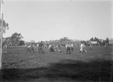
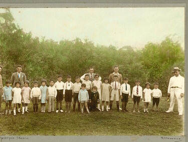
Photograph, Football Match at Maddingley Park Bacchus Marsh 1900s
... Football Match at Maddingley Park Bacchus Marsh 1900s...By close comparison with other images of Maddingley Park held by the Bacchus Marsh and District Historical Society the location has been identified as Maddingley Park, Bacchus Marsh. ...By close comparison with other images of Maddingley Park held by the Bacchus Marsh and District Historical Society the location has been identified as Maddingley Park, Bacchus Marsh. ...This photo is a very early example of an action image from an Australian Rules football match in a rural area in Victoria. The identity of the two teams is not confirmed. The team with the dark colored uniform is probably the Bacchus Marsh football team. The other team is possibly Parwan. The style of uniforms suggest the date of the photo is from around 1910 or possibly a few years earlier. This item has particular historic and social significance as an action image of two of the early sporting teams of Bacchus Marsh and district. These type of images are very rare for teams outside of the major metropolitan competitions such as the Victorian Football League of Victorian Football Association. It therefore provides a rare and fascinating depiction of an early football game as it was played and the ground conditions in which footballers played in the early 1900s.A black and white photograph produced from a digitized glass negative held by the State Library of Victoria titled, ‘Men and boys playing football on an oval set among trees and fields’ ca. 1910, Pictures Collection, State Library Victoria, H92.433/20. The description for the image held by the State Library of Victoria does not identify the location where the image was taken. By close comparison with other images of Maddingley Park held by the Bacchus Marsh and District Historical Society the location has been identified as Maddingley Park, Bacchus Marsh. A significant identifier for this image is the presence of the Evans Pavilion in the background which was built in 1896. Trees and statues in the background on the left side of the image also match other images of Maddingley Park from this time.australian rules football, bacchus marsh football club, australian rules football action images -
 Bacchus Marsh & District Historical Society
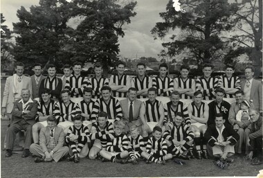
Photograph, Darley Football Team 1954
... This is incorrect as Maddingley Football club were the premiers in this year. ...Bacchus Marsh Express of Saturday 18 September 1954 reported "Decisive Win by Maddingley." The score was recorded as Maddingley 17.11 Darley 12.15. ...This is incorrect as Maddingley Football club were the premiers in this year. ...Darley Football club contested the 1954 Bacchus Marsh District Football Association Grand Final against Maddingley Football Club. This photograph is thought to have been taken in 1954. It is cited in some sources as the Premiership winning team of 1954. This is incorrect as Maddingley Football club were the premiers in this year. It is possibly a photo taken at the time of the Grand Final of 1954 and subsequently misidentified. Or, it may be a photo from another year in the 1950s.A black and white photograph print on a mounting board in a display folder, showing a group 30 men, 3 boys and one younger child seated on the knee of a man probably his father. The group is arranged in three rows, 10 in civilian clothes, the rest in vertically-striped guernseys and white shorts. In the front row, seated in the middle, are three boys, club mascots , dressed in uniform guernseys and shorts. Two of the men have towels slung over their shoulder, indicating that they were club trainers. The photo is taken in an outdoor setting, probably Maddingley Park. There are no names on the mounting board, but from information taken from "Bacchus Marsh. A Pictorial Chronicle", 1986, by Gwyn Moore and Jean Oomes. This source incorrectly identifies this team as Premiers 1954. Bacchus Marsh Express of Saturday 18 September 1954 reported "Decisive Win by Maddingley." The score was recorded as Maddingley 17.11 Darley 12.15. The names given in Moore and Oomes are: Back Row: l-r: M.Cook, B.Skinner, J.Cook, C.Reddrop, L.Holt, J.Cook, M.Carr, J.Carr, M. Younger, B.Carr, R.Stevens, W.Richardson, B.Giani. Middle Row: C.Casey, N.Thomson, N.Holt, G.Tudball, J.Ashby, L.Carr, L.Carr jnr., M.Younger, J.Moore, T.Densley, L.McKenzie Front Row: H.Cairns, P.Shea, L.Kight, M.Shea, R.Closter, A.Franklin, with mascots.darley football club, australian rules football -
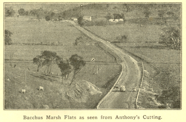 Federation University Historical Collection
Booklet, F.C. Mc C. Crisp, Bacchus Marsh Centenary Celebrations, 10/1936
... ...maddingley...Images include: * Bacchus Marsh Flats from Anthony's Cutting; * Manor house; * Scene in Maddingley Park * Werribee Valley; * Werribee Gorge * Maddingley Park lake; * ANA Hall and Post Office * Shire Hall and Soldiers' Memorial Hall, * State School No 28 * At Werribee Gorge ** The Gas Supply Co, Bacchus Marsh * Bacchus Marsh Shire Council, 1935-6 (named) Images depicted in the book were supplied by H.J.M. ...Lambert (Decorations manager) bacchus marsh merrimu guest house anthony's cutting captain bacchus manor house maddingley maddingley park werribee gorge bacchus marsh shire bacchus marsh shire council Brown covered book of 28 pages. ...Bacchus Marsh celebrated 100 years of white settlement in 1936. The centenary celebrations committee comprised of L.M. Dugdale (President), A.W. Bond (Hon. Secretary), Charles Dickie, W. Grant Morton, W.R. Vigor, C.J. McFarlane, G.H. Anderson, T.J. Shea, F.C. McC Crisp, Dr E. McDonald, Robert Elliott (treasurer), R.H. Lambert (Decorations manager)Brown covered book of 28 pages. The book includes an historical essay, official centenary programme, Electric Light Plant, Patriotic Bacchus Marsh, milk industry, Pioneer Women's Memorial Avenue, Bacchus Marsh Gas Works . The book includes numerous advertisement, some illustrated. Images include: * Bacchus Marsh Flats from Anthony's Cutting; * Manor house; * Scene in Maddingley Park * Werribee Valley; * Werribee Gorge * Maddingley Park lake; * ANA Hall and Post Office * Shire Hall and Soldiers' Memorial Hall, * State School No 28 * At Werribee Gorge ** The Gas Supply Co, Bacchus Marsh * Bacchus Marsh Shire Council, 1935-6 (named) Images depicted in the book were supplied by H.J.M. Vallancebacchus marsh, merrimu guest house, anthony's cutting, captain bacchus, manor house, maddingley, maddingley park, werribee gorge, bacchus marsh shire, bacchus marsh shire council -
 Federation University Historical Collection
Book, Back to Bacchus Marsh, 1957, 1957
... The book includes an historical essay, Maddingley Brown Coal, World war 11, Darley Military Camp, Darley Firebrick Co., industrial changes and numerous advertisements. ...Images include: * Grant Street Avenue *St Bernard's new Parish Hall and Schoolrooms * Maddingley No. 2 Cut * Terracing at Maddingley - part of the beautification scheme at Maddingley * Hospital entrance with War memorial Feature * Old Woolpack Inn * Jim Pyke * Infant Welfare and pre-School Centre, Young St * Bacchus Marsh Main Street looking East, 1872 * Andrew George Scott, alias Captain Moonlight * Grant Street Avenue * Ballarat State School No 28 featuring the World War One Memorial Clock Back to Bacchus Marsh, 1957 Book Crisp and sons ...A back to Bacchus Marsh was held from 12 to 20 October 1957.Brown covered book of 28 pages including the official programme for back to Bacchus Marsh, 1957. The book includes an historical essay, Maddingley Brown Coal, World war 11, Darley Military Camp, Darley Firebrick Co., industrial changes and numerous advertisements. Images include: * Grant Street Avenue *St Bernard's new Parish Hall and Schoolrooms * Maddingley No. 2 Cut * Terracing at Maddingley - part of the beautification scheme at Maddingley * Hospital entrance with War memorial Feature * Old Woolpack Inn * Jim Pyke * Infant Welfare and pre-School Centre, Young St * Bacchus Marsh Main Street looking East, 1872 * Andrew George Scott, alias Captain Moonlight * Grant Street Avenue * Ballarat State School No 28 featuring the World War One Memorial Clock maddingley brown coal, world war 11, old woolpack inn, darley military camp, darley firebrick, jim pyke, andrew george scott, captain moonlite, bacchus marsh, world war, bacchus marsh state school no 28, grant street avenue, bacchus marsh war memorial hospital, bacchus marsh avenue of honour, captain bacchus -
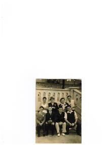 Ithacan Historical Society
Photograph, Ithacan Picnic
... A group of Ithacan men at an annual picnic at Maddingley Park, Bacchus Marsh....Ithacan Historical Society Ithaca House 329 Elizabeth Street Melbourne melbourne A group of Ithacan men at an annual picnic at Maddingley Park, Bacchus Marsh. Black and white photograph of eight, four standing and four seated in front of a sporting stand. ...A group of Ithacan men at an annual picnic at Maddingley Park, Bacchus Marsh.Black and white photograph of eight, four standing and four seated in front of a sporting stand. One man is holding a guitar. -
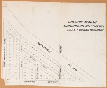 Bacchus Marsh & District Historical Society
Map, Bacchus Marsh Suburban Allotments Parwan Road Lodge & Dunn's Paddocks 1888
... A single page paper map showing allotments of land for sale along the Parwan Road in Maddingley. The map is pasted into a bound volume containing 76 maps or plans in total. ...Land Sales Bacchus Marsh Land Sales Maddingley Bacchus Marsh Victoria Maps Maddingley Victoria Maps A single page paper map showing allotments of land for sale along the Parwan Road in Maddingley. ...This map was created as a plan for an auction of land close to the Bacchus Marsh Railway Station. The auction took place on 23 October 1888. 102 allotments of land from an area known as Lodge and Dunn's paddocks was offered for sale. A single page paper map showing allotments of land for sale along the Parwan Road in Maddingley. The map is pasted into a bound volume containing 76 maps or plans in total. High resolution digital image stored on BMDHS computer network. land sales bacchus marsh, land sales maddingley, bacchus marsh victoria maps, maddingley victoria maps -
 Bacchus Marsh & District Historical Society
Map, Bacchus Marsh Tuesday 23rd Oct. 1888, Lodge & Dunn's Paddocks 1888. Business and Mansion Sites
... A single page paper map showing allotments of land for sale along the Parwan Road in Maddingley. The map is pasted into a bound volume containing 76 maps or plans in total. ...Land Sales Bacchus Marsh Land Sales Maddingley Bacchus Marsh Victoria Maps Maddingley Victoria Maps At bottom on left side: 'Harston & Co. ...This map was created as a plan for an auction of land close to the Bacchus Marsh Railway Station. The auction took place on 23 October 1888. 102 allotments of land from an area known as Lodge and Dunn's paddocks was offered for sale. The auction was conducted by auctioneers based in Melbourne and was advertised in Melbourne newspapers as well as in the Bacchus Marsh Express newspaper. The auction plan contains a range of details including the selling agents, Munro and Baillieu; W.P. Lockhart; and John Turner, all of Melbourne, deposit terms for purchases, price of railway passes for a return trip from Melbourne to Bacchus Marsh of 1 shilling, and a description of the land as having 'magnificent views and perfect drainage'. A single page paper map showing allotments of land for sale along the Parwan Road in Maddingley. The map is pasted into a bound volume containing 76 maps or plans in total. High resolution digital image stored on BMDHS computer network. At bottom on left side: 'Harston & Co. Lith, Melb.'land sales bacchus marsh, land sales maddingley, bacchus marsh victoria maps, maddingley victoria maps -
 Bacchus Marsh & District Historical Society
Photograph, Police Barracks 117 Main Street Bacchus Marsh 1883
... Prior to this the Police were stationed in the Police Paddocks at Maddingley in the area where Maddingley Park is now located. ...Prior to this the Police were stationed in the Police Paddocks at Maddingley in the area where Maddingley Park is now located. ...The Bacchus Marsh Police Barracks shown in this image were located in Main Street on the site of the present day Police Station. The Barracks were constructed around 1857 or 1858. Prior to this the Police were stationed in the Police Paddocks at Maddingley in the area where Maddingley Park is now located. This building was in use by the Police until 1930 when it was replaced by a new building. This later building was in use until the early 2000s but was demolished in 2003 and replaced by a larger Police building.Small sepia unframed photograph on card with gold border framing photograph. Housed in the album, 'Photographs of Bacchus Marsh and District in 1883 by Stevenson and McNicoll'. The image shows the Bacchus Marsh Police Police Barracks and stables in 1883. Two uniformed male police officers wearing helmets can be seen standing on the footpath in front of the building. Next to them on their left stand two boys, one holding a document, possibly a newspaper.. The Barracks is a sandstone building with a chimney on one side; it appears to have a slate roof. Two buildings can be seen behind the main building. A white picket fence with a double gate runs along the front of the complex.On the front: Stevenson & McNicoll. Photo. 108 Elizabeth St. Melbourne. COPIES CAN BE OBTAINED AT ANY TIME. On the back: LIGHT & TRUTH inscribed on a banner surmounted by a representation of the rising sun. Copies of this Portrait can be had at any time by sending the Name and Post Office Money Order or Stamps for the amount of order to STEVENSON & McNICOLL LATE BENSON & STEVENSON, Photographers. 108 Elizabeth Street, MELBOURNE. stevenson and mcnicoll 1883 photographs of bacchus marsh and district, bacchus marsh police station, police stations, police -
 Ithacan Historical Society
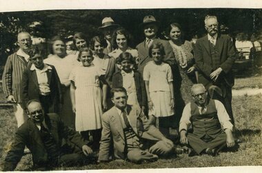
Photograph, Ithacan picnic, c1930s
... The photograph was taken at one of the annual Ithacan picnics in the 1030s held in a large sports ground, possibly Maddingley Recreation Reserve Bacchus. Everyone who came to the picnic is pictured....Ithacan Historical Society Ithaca House 329 Elizabeth Street Melbourne melbourne The photograph was taken at one of the annual Ithacan picnics in the 1030s held in a large sports ground, possibly Maddingley Recreation Reserve Bacchus. Everyone who came to the picnic is pictured. ...The photograph was taken at one of the annual Ithacan picnics in the 1030s held in a large sports ground, possibly Maddingley Recreation Reserve Bacchus. Everyone who came to the picnic is pictured.A black and white photograph of a large group of people photographed sitting and standing in front of a grandstand in a sports ground. -
 Bacchus Marsh & District Historical Society
Postcard, Join us in a trip around Bacchus Marsh Victoria
... The eight scenes are: Railway Station Bacchus Marsh; Bacchus Marsh Post Office; Main Street Bacchus Marsh; The Avenue Bacchus Marsh; Maddingley Bridge; Swimming Pool Bacchus Marsh; Rustic Bridge Maddingley Park; View Across Maddingley Flats. ...The eight scenes are: Railway Station Bacchus Marsh; Bacchus Marsh Post Office; Main Street Bacchus Marsh; The Avenue Bacchus Marsh; Maddingley Bridge; Swimming Pool Bacchus Marsh; Rustic Bridge Maddingley Park; View Across Maddingley Flats. ...This fold out series of black and white images shows scenes of Bacchus Marsh in the late 1930s or during the 1940s. The date of the set of images is not stated but it shows the Bacchus Marsh Swimming Pool constructed in 1938. The general purpose of the images to promote tourism suggests the collection may date from the post war period of the late 1940s or early 1950s when petrol rationing and other wartime restrictions were being discontinued. The eight scenes are: Railway Station Bacchus Marsh; Bacchus Marsh Post Office; Main Street Bacchus Marsh; The Avenue Bacchus Marsh; Maddingley Bridge; Swimming Pool Bacchus Marsh; Rustic Bridge Maddingley Park; View Across Maddingley Flats. The cover illustration of the fold out envelope shows a happy family in a new model car. The message of the image clearly being to encourage people to travel by motor car to places like Bacchus Marsh for recreation and to engage in the general pastime of tourism.One set of 8 fold out black and white photos showing various scenes of Bacchus, with a cover illustration of a family traveling in a motor car. Measurements: 112 x 90 mm folded; 112 x 750 mm unfoldedSouthern Series Registeredbacchus marsh history, bacchus marsh views, bacchus marsh postcards -
 Federation University Historical Collection
Booklet, Back to Bacchus Marsh, 1930, 1930
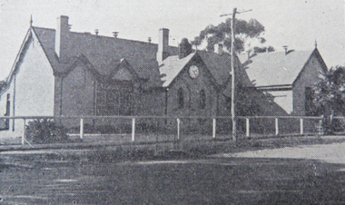
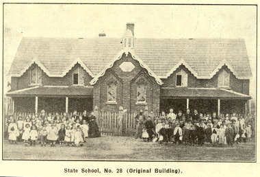
... ...maddingley...Contents include Bacchus Marsh and its soldiers, Red Cross, Lerderderg Gorge, Werribee Gorge, Lerderderg Park, Coimadai, Darely Firebrick Co., Myrniong, Underbank, Balliang, Rowsley, Parwan, schoosl, churches, Shire Council, Federal Milk Pty Ltd, Bacchus Marsh Milk, Old Maddingley Bridge Images include: * Bacchus Marsh looking east, 1930 * Bacchus Marsh Looking West, 1872 * Bacchus Marsh Looking West, 1930 * Aerial View of Bacchus Marsh Township looking east * Aerial View of Bacchus Marsh Township looking south * Bacchus Marsh Agricultural Society & Pastoral Society, 1893 (named), * Original Bacchus Marsh State School No 28 * Holy Trinity Bacchus Marsh * Bacchus Marsh Baptist Church * St Bernard's Catholic Church * Bacchus Marsh Methodist Church * St Andrew's Presbyterian Church Bacchus Marsh * View of Maddingley Park, showing Original Courthouse, 1890 * Werribee Gorge * Underbank Stud Farm * Ballarat State School Number 28. ...(Back to Bacchus Marsh, 1930) bacchus marsh maddingley maddingley park underbank lerderderg park coimadai darely firebrick co. myrniong balliang rowsley parwan schoosl churches shire council federal milk pty ltd bacchus marsh milk old maddingley bridge police police paddock maddingley gates crisp mccormack cain harkness howe bence mcdonald mcfarlane cosgrave flagg burnip scott lodge cameron vallance bacchus marsh state school bacchus marsh state school no 28. geology r.w. thompson lederderg gorge weribee gorge comadai darley firebrick company Signed 'C. ...The 1930 Back to Bacchus Marsh celebrations were held on 23 to 28 October 1930. The committee were Cr L.M. Gugdale (president), A.W. Bond (General secretary), W. Grant Morton, J.G. Wells, Dr E. McDonald, Charles Dickie, G.H. Anderson, F.M. Crisp, W.R. Vigor. Bacchus Marsh State School No. 28 was established in 1851 as a National School in a rented building on the right-hand side of Bacchus Marsh-Melbourne Road, just beyond Woolpack Inn. Several willow trees mark the site. H.G. Ball was the first Head Teacher of the school, and the enrolmen towas 34. In 1854 Governor Charles Hotham visited the school. In 1855 two new schools, East and West, were recommended. School No. 28 closed in 1862 and the sitre was sold. The present school site was purchased in 1865 for 67 pounds. The cost of the building was 782 pounds. (Visions and Realisations, Vol 3., 1973) A clock purchased by public subscription was placed in the front of the building to the memory of scholars who served during World War One. (Back to Bacchus Marsh, 1930)Brown covered book of 44 pages. Contents include Bacchus Marsh and its soldiers, Red Cross, Lerderderg Gorge, Werribee Gorge, Lerderderg Park, Coimadai, Darely Firebrick Co., Myrniong, Underbank, Balliang, Rowsley, Parwan, schoosl, churches, Shire Council, Federal Milk Pty Ltd, Bacchus Marsh Milk, Old Maddingley Bridge Images include: * Bacchus Marsh looking east, 1930 * Bacchus Marsh Looking West, 1872 * Bacchus Marsh Looking West, 1930 * Aerial View of Bacchus Marsh Township looking east * Aerial View of Bacchus Marsh Township looking south * Bacchus Marsh Agricultural Society & Pastoral Society, 1893 (named), * Original Bacchus Marsh State School No 28 * Holy Trinity Bacchus Marsh * Bacchus Marsh Baptist Church * St Bernard's Catholic Church * Bacchus Marsh Methodist Church * St Andrew's Presbyterian Church Bacchus Marsh * View of Maddingley Park, showing Original Courthouse, 1890 * Werribee Gorge * Underbank Stud Farm * Ballarat State School Number 28. Signed 'C. Hodgson'bacchus marsh, maddingley, maddingley park, underbank, lerderderg park, coimadai, darely firebrick co., myrniong, balliang, rowsley, parwan, schoosl, churches, shire council, federal milk pty ltd, bacchus marsh milk, old maddingley bridge, police, police paddock, maddingley gates, crisp, mccormack, cain, harkness, howe, bence, mcdonald, mcfarlane, cosgrave, flagg, burnip, scott, lodge, cameron, vallance, bacchus marsh state school, bacchus marsh state school no 28., geology, r.w. thompson, lederderg gorge, weribee gorge, comadai, darley firebrick company -
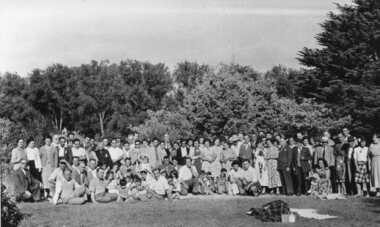 Ithacan Historical Society
Photograph, Ithacan picnic, c1947
... The picnics were usually held at location on the outskirts of Melbourne and for many years Bacchus Marsh's Maddingley Park was a popular location for the picnic...The picnics were usually held at location on the outskirts of Melbourne and for many years Bacchus Marsh's Maddingley Park was a popular location for the picnic The annual picnic has been held annually since 1918, except for 1919 when it was postponed due to outbreak of the Spanish Influenza in Melbourne, and in 2021 due to the Covid pandemic. ...The group photo was taken at the annual Ithacan Philanthropic Society picnic at Bacchus Marsh. The first picnic was held in 1918 at South Morang. The picnics were usually held at location on the outskirts of Melbourne and for many years Bacchus Marsh's Maddingley Park was a popular location for the picnicThe annual picnic has been held annually since 1918, except for 1919 when it was postponed due to outbreak of the Spanish Influenza in Melbourne, and in 2021 due to the Covid pandemic. In the early years the annual picnic gave families a chance to spend time in the countryside and to socialize with other Ithacans. It remains a popular event on the society's social calendar where families of generations with Ithacan ancestry catch up.A black and white photograph with a thin white border of a large group of people standing and sitting together in a large open area. There are trees in the background. Stamped on the back in black: 45 49. -
![Map, Millbank Estate Bacchus Marsh Thursday 4th October 1888 [Land sales], 1924](/media/collectors/5e461d8021ea67224c82f2a1/items/67765662eb6d2cbd24e0797f/item-media/67765682eb6d2cbd24e07a41/item-fit-380x285.jpg?cb=6) Bacchus Marsh & District Historical Society
Bacchus Marsh & District Historical SocietyMap, Millbank Estate Bacchus Marsh Thursday 4th October 1888 [Land sales], 1924
... The lots had frontages to Ballarat Road (Main Street), Maddingley Road (now Grant Street), Turner Street, Millbank Street, Clarinda Road (now Clarinda Street), and an unnamed street south of Turner Street (possibly known as Grant Street at this time) which connected to Maddingley Road through the vicinity of the present day Bacchus Marsh Hospital. ...The lots had frontages to Ballarat Road (Main Street), Maddingley Road (now Grant Street), Turner Street, Millbank Street, Clarinda Road (now Clarinda Street), and an unnamed street south of Turner Street (possibly known as Grant Street at this time) which connected to Maddingley Road through the vicinity of the present day Bacchus Marsh Hospital. ...The Millbank Estate was a parcel of land close to the centre of the shopping area of Bacchus Marsh which was sub-divided and offered for sale in 62? lots on the 4th October 1888. The lots had frontages to Ballarat Road (Main Street), Maddingley Road (now Grant Street), Turner Street, Millbank Street, Clarinda Road (now Clarinda Street), and an unnamed street south of Turner Street (possibly known as Grant Street at this time) which connected to Maddingley Road through the vicinity of the present day Bacchus Marsh Hospital. This was a significant sub-division of land and represented a major expansion of residential housing in Bacchus Marsh in the late 19th century. The map includes a wealth of detail about the time of the sale, where it will take place, who the selling agents were, the deposit terms for purchases and details of a special train from Melbourne to Bacchus Marsh on sale day. The location of the allotments in relation to the shopping and commercial area of Bacchus Marsh, Maddingley and the railway station are indicated on an inset map within the overall map and poster. The Millbank Estate area was an area which had once belonged to the Grant family who were prominent early citizens of Bacchus Marsh and lived in a house in this area known as 'Millbank'.This land sale map is a typical example of housing estate land sales advertising maps produced by real estate agents in this era. The map is significant for the detailed information it provides about when and where land was sold for new housing estates in Bacchus Marsh in the late nineteenth century.Single page map showing land allotments for sale at auction in Bacchus Marsh in October 1888. A significant portion of the map is missing from the bottom right side. land sales bacchus marsh, land subdivsion bacchus marsh, housing estates land sales bacchus marsh, grant family bacchus marsh, millbank estate land sales -
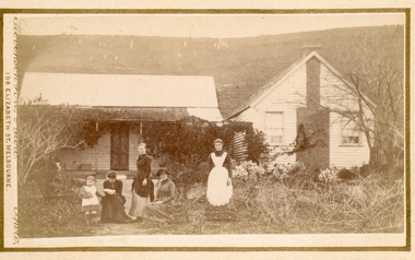 Bacchus Marsh & District Historical Society
Photograph, Group of women at a farmhouse near Bacchus Marsh 1883
... Tilleys Road in Maddingley is probably named for this family farm....Tilleys Road in Maddingley is probably named for this family farm. ...This image is one of several family group portraits taken by Stevenson and McNicoll on rural properties. This property has been identified as that of John Tilley at Parwan’s Creek. The people depicted are presumably members of the Tilley family. The dwelling has since been demolished. Tilleys Road in Maddingley is probably named for this family farm.Small sepia unframed photograph on card with gold border framing photograph. Housed in the Jeremeas Family Album which contains photographs of Bacchus Marsh and District in 1883 by Stevenson and McNicoll. The property has been identified as that of John Tilley at Parwan’s Creek. This property has since been demolished. Presumably, the photo is of members of the Tilley family. The image shows a family group of four women and one young child. It is unclear if the child is a boy or a girl, due to the custom of clothing young male children in dresses. The women are sitting or standing in two groups. To the right stands an older woman in a starched white apron, perhaps indicating that she is the housekeeper. The group on the left is of one woman standing and two women seated, one reading a newspaper or magazine. The young child reaches out one arm to her, perhaps for reassurance. The dwelling consists of two structures, one single storeyed cottage, which is perhaps the older part, and an adjoining weatherboard house with a steeply pitched roof and a prominent chimney at the front. The cottage has a shingled verandah partially covered by corrugated iron, which also covers the roof. Trees, a climbing vine and shrubs form a rather unkempt garden. On the hill rising behind the farmhouse there can be seen animals, possibly sheep, grazing.On the front: Stevenson & McNicoll. Photo. 108 Elizabeth St. Melbourne. COPIES CAN BE OBTAINED AT ANY TIME. On the back: LIGHT & TRUTH inscribed on a banner surmounted by a representation of the rising sun. Copies of this Portrait can be had at any time by sending the Name and Post Office Money Order or Stamps for the amount of order to STEVENSON & McNICOLL LATE BENSON & STEVENSON, Photographers. 108 Elizabeth Street, MELBOURNE. stevenson and mcnicoll 1883 photographs of bacchus marsh and district, farmhouses, families, women bacchus marsh -
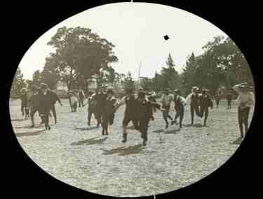 Bacchus Marsh & District Historical Society
Photograph, Two legged race, possibly at an A.N.A. Sports Carnival, Bacchus Marsh ca 1900s
... Another possible location is Maddingley Park, Bacchus Marsh, close to the location of the Showgrounds in the 1900s. ...Another possible location is Maddingley Park, Bacchus Marsh, close to the location of the Showgrounds in the 1900s. ...This image shows a two-legged race where participants are tied to the leg of another runner who then compete against other runners who are tethered together in the same way. These two-legged races are known to have been part of community sports carnivals in the 1900s in Bacchus Marsh. This event may have been part of the annual Australian Natives Association (A.N.A,) annual sports festival which was held over the Easter period. In the 1900s in Bacchus Marsh this sports carnival was held in the Bacchus Marsh Showgrounds which was located where the present day Bacchus Marsh High School now stands (2026). Another possible location is Maddingley Park, Bacchus Marsh, close to the location of the Showgrounds in the 1900s. A large tree in the background on the right hand side of the image resembles a distinctive shaped tree which still stands in Maddingley Park in 2026.One digital file acquired from State Library of Victoria. One print copy for BMDHS collection reproduced from digital file. BMDHS Location: Photo Album - Entertainment and Recreation parades and processions, events and activities, bacchus marsh and district images held by state library of victoria, sports and recreations, sports carnivals -
 Ithacan Historical Society
Photograph, Ithacan picnic
... For many years Maddingley Reserve, Bacchus Marsh was the regular location; and more recently Ferny Creek Reserve. ...For many years Maddingley Reserve, Bacchus Marsh was the regular location; and more recently Ferny Creek Reserve. ...The photograph was taken at an Ithacan Club annual picnic. The picnic were held on recreation grounds located on Melbourne's rural fringe. For many years Maddingley Reserve, Bacchus Marsh was the regular location; and more recently Ferny Creek Reserve. Running races continue to be run for all age groups are a popular activity during the day. In this photograph the children are lining up for the 75 yards race.A sepia photograph taken in the country of a row of children lining up at thew start of a race. Five men are standing behind them. -
 Ithacan Historical Society
Photograph, Picnic group, c late1930s
... The picnic was most likely held at Maddingley Park, Bacchus Marsh as it was the regular site for the picnic up until 1980 following which a move was made to the Ferny Creek Reserve, now the regular venue. ...The picnic was most likely held at Maddingley Park, Bacchus Marsh as it was the regular site for the picnic up until 1980 following which a move was made to the Ferny Creek Reserve, now the regular venue. ...The group gathered for the photograph were enjoying themselves at an annual Ithacan Picnic during the 1930s. The picnic was most likely held at Maddingley Park, Bacchus Marsh as it was the regular site for the picnic up until 1980 following which a move was made to the Ferny Creek Reserve, now the regular venue. Notable from early picnic photos is the effort that was made to dress for the picnic; men in suits and women in smart outfits.A black and white photograph of people standing in an sports ground. There are seven men and five ladies as well as three young girls and a boy. Three of the men are sitting in front of the group on the ground. -
 Bacchus Marsh & District Historical Society
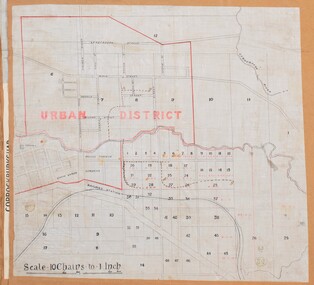
Map, Bacchus Marsh Urban District
... The 'urban district' is indicated by red drawn lines on the map and includes streets and blocks on the northern side of the Werribee River in Bacchus Marsh, and streets and blocks south of the Werribee in Maddingley. Scale 10 chains to 1 inch. The map is pasted into a bound volume containing 76 maps or plans in total. ...Bacchus Marsh Victoria Maps Maddingley Victoria Maps A single page paper map showing blocks of land in the urban district of Bacchus Marsh. ...The date of this map has not been established but the date would be sometime after 1887 as the Bacchus Marsh Railway Station, which opened in 1887, is shown on the map. A single page paper map showing blocks of land in the urban district of Bacchus Marsh. The 'urban district' is indicated by red drawn lines on the map and includes streets and blocks on the northern side of the Werribee River in Bacchus Marsh, and streets and blocks south of the Werribee in Maddingley. Scale 10 chains to 1 inch. The map is pasted into a bound volume containing 76 maps or plans in total. High resolution digital image stored on BMDHS computer network. bacchus marsh victoria maps, maddingley victoria maps -
 Bacchus Marsh & District Historical Society
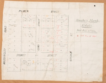
Map, Bacchus Marsh Estate sold 30th June 1888 and sold 28 December 1895
... Single page map showing allotments of land bounded by Pilmer Street, Graham Street, Sydney Street and Maddingley Road (Grant Street) in Bacchus Marsh.The area is dissected by Como Street down the central area. 43 blocks of land are shown with the names of buyers or sellers in 1888 written in black in. ...Bacchus Marsh Victoria Maps Land Sales Bacchus Marsh Pilmer Street Bacchus Marsh Graham Street Bacchus Marsh Sydney Street Bacchus Marsh Como Street Bacchus Marsh Maddingley Road Bacchus Marsh Grant Street Bacchus Marsh Single page map showing allotments of land bounded by Pilmer Street, Graham Street, Sydney Street and Maddingley Road (Grant Street) in Bacchus Marsh.The area is dissected by Como Street down the central area. 43 blocks of land are shown with the names of buyers or sellers in 1888 written in black in. ...Blocks of land in this area of Bacchus Marsh were sold in lots between 1888 and the late 1890s. This map shows sales made in 1888 and 1895.Single page map showing allotments of land bounded by Pilmer Street, Graham Street, Sydney Street and Maddingley Road (Grant Street) in Bacchus Marsh.The area is dissected by Como Street down the central area. 43 blocks of land are shown with the names of buyers or sellers in 1888 written in black in. Buyers or sellers for December 1895 are written in red ink. Part of a set of maps which are pasted into a bound volume containing 76 maps or plans in total. High resolution digital image stored on BMDHS computer network. bacchus marsh victoria maps, land sales bacchus marsh, pilmer street bacchus marsh, graham street bacchus marsh, sydney street bacchus marsh, como street bacchus marsh, maddingley road bacchus marsh, grant street bacchus marsh -
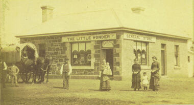 Bacchus Marsh & District Historical Society
Photograph, Alford's Little Wonder Store Bacchus Marsh 1883
... The Little Wonder Store was built in 1883 from materials of the demolished Maddingley School. It was located on the corner of Grant Street and Labilliere Street. ...Bacchus Marsh & District Historical Society Lerderderg Library Main Street Bacchus Marsh The Little Wonder Store was built in 1883 from materials of the demolished Maddingley School. It was located on the corner of Grant Street and Labilliere Street. ...The Little Wonder Store was built in 1883 from materials of the demolished Maddingley School. It was located on the corner of Grant Street and Labilliere Street. In 1886 James Alford obtained a licence to conduct the Railway Hotel and General Store there. A second storey was added later and the building continued to operate as the Railway Hotel. It was destroyed by fire in 1998. The photo also shows the covered wagon of a travelling salesman, who were known as ‘hawkers’, who were significant in the supply of goods and news to outlying towns and districts before the development of road and rail networks. Small sepia 'carte de viste' style unframed photograph on card with gold border framing photograph. Housed in the Jeremeas Family Album which contains photographs of Bacchus Marsh and District in 1883 by the photographers Stevenson and McNicoll. The photo shows a single-storey building of bluestone and brick with two signs on the front and side, the front sign reading “THE LITTLE WONDER” and the side sign “GENERAL STORE”. Above the door is a sign with the name ‘James Alford’. The windows display the merchandise of the store. Outside the store is a travelling salesman’s cart pulled by two horses. The salesman sits in the cart ready to drive off. Standing along the street outside the store are three men, three women and two young children.Printed On the front: Stevenson & McNicoll. Photo. 108 Elizabeth St. Melbourne. COPIES CAN BE OBTAINED AT ANY TIME. On the back: LIGHT & TRUTH inscribed on a banner surmounted by a representation of the rising sun. Copies of this Portrait can be had at any time by sending the Name and Post Office Money Order or Stamps for the amount of order to STEVENSON & McNICOLL LATE BENSON & STEVENSON, Photographers. 108 Elizabeth Street, MELBOURNE. stevenson and mcnicoll 1883 photographs of bacchus marsh and district, shops bacchus marsh, general stores bacchus marsh vic., hawkers, hotels bacchus marsh