Showing 560 items matching "map-railway victorian-railways"
-
 Orbost & District Historical Society
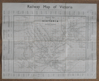
map, Railway Map of Victoria, 1.8.1965
... map-railway Victorian-Railways...railway was opened in 1916 to serve the agricultural and timber industry. Because of the decline in traffic and heavy operating costs, the line was finally closed in August, 1987. This item is associated with the history of the Orbost-Bairnsdale railway line and therefore reflects the role that the rail line played in the social and economic history of Orbost. map-railway Victorian-Railways A large rectangular shaped paper map of all railway stations in Victoria. ...The Bairnsdale-Orbost railway was opened in 1916 to serve the agricultural and timber industry. Because of the decline in traffic and heavy operating costs, the line was finally closed in August, 1987.This item is associated with the history of the Orbost-Bairnsdale railway line and therefore reflects the role that the rail line played in the social and economic history of Orbost.A large rectangular shaped paper map of all railway stations in Victoria. It is dated 1st August 1965. It is divided into grids. Stations are listed around the map. A key is provided and each station has a grid reference.map-railway victorian-railways -
 Ringwood and District Historical Society
Map, Victorian Railways Map showing country lines existing and under construction c1875 (or possibly 1890?)
... Map Showing Victorian Railways Railways Department No 162 Handwritten "1875"...Ringwood and District Historical Society 125A Warrandyte Road Ringwood North melbourne Map Showing Victorian Railways Railways Department No 162 Handwritten "1875" An 4 photocopy of map. ...An 4 photocopy of map. No details of original source. However there is a State Library Victoria record (See References) which states year as c1890 Map Showing Victorian Railways Railways Department No 162 Handwritten "1875" -
 Warrnambool and District Historical Society Inc.
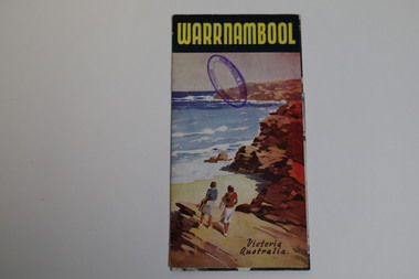
Pamphlet - Tourist Map and Guide, Victorian Railway Commissioners, Warrnambool Victoria Australia, c. 1950
... railway came to Warrnambool in 1890 and has always been promoted as a convenient mode of travel to the town/city. The illustration on the front cover of this pamphlet is reminiscent of the promotional illustrations and photographs that once featured in Victorian Railway carriages. Tourism is still an important aspect of Warrnambool's economy. This tourist guide is a fine example of those produced for the City of Warrnambool in the late 1940s and early 1950s. Tourism in Warrnambool Warrnambool Rail Warrnambool Tourist Guides Warrnambool Tourist Map and Guide .1 This is a single sheet of paper folded twice to make a pamphlet. It has a multi-coloured map (predominantly yellow), an illustration, several black and white photographs, printed text and coloured headings. .2 This is a single sheet of paper inserted into item 1. It is folded twice and contains black and white photographs. Warrnambool Victoria Australia Pamphlet Tourist Map and Guide Victorian Railway ...Warrnambool Tourist Map and Guide.1 This is a single sheet of paper folded twice to make a pamphlet. It has a multi-coloured map (predominantly yellow), an illustration, several black and white photographs, printed text and coloured headings. .2 This is a single sheet of paper inserted into item 1. It is folded twice and contains black and white photographs.non-fictionWarrnambool Tourist Map and Guidetourism in warrnambool, warrnambool rail, warrnambool tourist guides -
 Warrnambool and District Historical Society Inc.
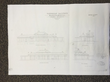
Map, Victorian Railway W'bool No1 & No2, 1897
... railway station buildings ‘Victorian Railways, Warrnambool, Station Buildings, Scale 8 feet to one inch, Contract No. 6379B (Nos. 1 and 2)’ These are two architect’s plans and drawings of the Warrnambool Railway Station building (1897). The drawings are black and white and the first plan shows the ground floor plan and the first floor plan and the outbuildings. The second plan shows drawings of the building with its elevation to the platform and its elevation to Merri Street. There are two stamps of the Railways Department, Melbourne. These are copies, not originals. Victorian Railway W'bool No1 & No2 Map ...These two sheets show the 1897 plans drawn up by the Victorian Railways for the erection of the Warrnambool Railway Station building. It is a two-storey building still existing today. The railway came to Warrnambool in 1890 and they must have used temporary buildings for seven years before this railway building was erected. It had offices, booking counter and public facilities on the ground floor and housing for the Station Master on the first floor. The building erected was a typical design for country town railway stations and many of similar design were erected in the 1880s and 90s. These plans are important because they show clearly the design of the Warrnambool Railway Station buildings when they were first erected in the 1890s.They will be very useful for researchers. The coming of the railway was a significant event in Warrnambool’s history and did much to make the port and shipping a less viable proposition.These are two architect’s plans and drawings of the Warrnambool Railway Station building (1897). The drawings are black and white and the first plan shows the ground floor plan and the first floor plan and the outbuildings. The second plan shows drawings of the building with its elevation to the platform and its elevation to Merri Street. There are two stamps of the Railways Department, Melbourne. These are copies, not originals. ‘Victorian Railways, Warrnambool, Station Buildings, Scale 8 feet to one inch, Contract No. 6379B (Nos. 1 and 2)’warrnambool, railway station buildings -
 Warrnambool and District Historical Society Inc.
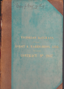
Document - Victorian Railways. Koroit & Warrnambool Line. Contract No. 2937, Circa 1888
... Victorian Railways began in 1854 and in the first 14 years up to 1868 had managed to complete about 250 miles of track. The next 60 years saw the system expand to nearly 3000 miles. By 1931 every town with a population over 500 had its own railway station. Early Victorian railway maps...Victorian Railways began in 1854 and in the first 14 years up to 1868 had managed to complete about 250 miles of track. The next 60 years saw the system expand to nearly 3000 miles. By 1931 every town with a population over 500 had its own railway station. Early Victorian railway maps ...The Victorian Railways began in 1854 and in the first 14 years up to 1868 had managed to complete about 250 miles of track. The next 60 years saw the system expand to nearly 3000 miles. By 1931 every town with a population over 500 had its own railway station. Early Victorian railway maps indicate that the extension from Colac to Warrnambool and then onwards to Koroit, occurred in the period of the 1880’s when the act known as the Octopus act saw a rapid expansion of lines. At the time there was much debate over where the expansion of the lines should take place, with one of the prime considerations for Warrnambool was the impact it would have on its port.The building of the railway to Warrnambool and onward to Koroit was a significant event for the town. Green cloth cover with tan suede corner points and spine. Title printed in gold on front cover. Title printed in gold on red on spine. 92 pages. The contract is printed and includes handwritten entries with specifications.Handwritten on front cover and inside front cover ” Copy for Engr in Chief” .On Page 2 transferred to Allan Reid * 24/1/88 Co Briscoe & Co Little Collins Street, Melbourne.warrnambool, railways, warrnambool to koroit railway, victorian railways contract no 2937 -
 Kiewa Valley Historical Society
Map - Railway Map of Victoria, Amended to 1/11/1945
... Victorian railways 1945 trains transport Plastic on parchment with detailed railway routes (in green) across Victoria including each district's 'Road Foremen' and 'Depots'. There is a length of flat wood attached by 10 tacks across the top of the map ...Railways began in the 1850s and were privately owned and operated. Later they were taken over by the Victorian Government reaching a peak in the early 1940s.Steam trains were followed by electric trains with both running after the war in 1945.Bright was the closest station to the Kiewa Valley but road transport was used more often as the Kiewa Valley Highway was improved with the construction of the Kiewa Hydro Electric Scheme. To travel to Melbourne or Sydney by train residents went via Wodonga/Albury where they also did their shopping.Plastic on parchment with detailed railway routes (in green) across Victoria including each district's 'Road Foremen' and 'Depots'. There is a length of flat wood attached by 10 tacks across the top of the mapvictorian railways 1945, trains, transport -
 Eltham District Historical Society Inc
Photograph, George Coop, Steam locomotive N-430 and the Victorian Centenary Jubilee train at Spencer Street Railway Station, Feb. 1951
... maps of the Snowy Mountains Hydro-Electric scheme. The Railways exhibit portrayed the century's growth and development of railways in Victoria and their influence on the prosperity of the State. During its 6,000 miles tour, from 1st February to 30th June, the train visited 168 stations and was inspected by 547,978 people. An entertainment unit accompanied the train and gave 100 performances which were attended by 96,400 people. Source: Report of The Victorian...maps of the Snowy Mountains Hydro-Electric scheme. The Railways exhibit portrayed the century's growth and development of railways in Victoria and their influence on the prosperity of the State. During its 6,000 miles tour, from 1st February to 30th June, the train visited 168 stations and was inspected by 547,978 people. An entertainment unit accompanied the train and gave 100 performances which were attended by 96,400 people. Source: Report of The Victorian ...The Centenary-Jubilee Train. The Centenary-Jubilee train was one of the outstanding successes of the Centenary and Jubilee celebrations in Victoria. The train, attractively painted green and gold, consisted of eleven cars, and toured Victoria to take to people in the country exhibits of interest associated with the celebrations. National Art Gallery paintings, rare manuscripts and pictures were displayed, as well as models showing the history of gold production, and models and illustrations of national projects controlled by the various departments of this State. The Commonwealth section included displays by the Army, Navy, Air Force and Post Office; a war materials exhibit from the Supply Department; and diagrams and maps of the Snowy Mountains Hydro-Electric scheme. The Railways exhibit portrayed the century's growth and development of railways in Victoria and their influence on the prosperity of the State. During its 6,000 miles tour, from 1st February to 30th June, the train visited 168 stations and was inspected by 547,978 people. An entertainment unit accompanied the train and gave 100 performances which were attended by 96,400 people. Source: Report of The Victorian Railways Commissioners for the Year Ended 30th June 1951Digital TIFF file Scan of Kopdak 620 black and white negative transparencygeorge coop collection, n-430, n-class steam locomotive, victorian centenary jubilee 1951 -
 Eltham District Historical Society Inc
Photograph, Tess Justine (Nillumbik Shire Council), Murray's Bridge over the Diamond Creek, Eltham North, 19 Feb 2022
... railway line came to Eltham in 1902. • The extension of the railway from Eltham to Hurstbridge was constructed in 1912 so no railway line even existed through Murray's property until 1912 and the Victorian Railways maps at the time show no such siding on Murray’s property. • In 1923 a new company was formed in anticipation of the old Diamond Creek Gold Mine being re-opened. ...railway line came to Eltham in 1902. • The extension of the railway from Eltham to Hurstbridge was constructed in 1912 so no railway line even existed through Murray's property until 1912 and the Victorian Railways maps at the time show no such siding on Murray’s property. • In 1923 a new company was formed in anticipation of the old Diamond Creek Gold Mine being re-opened. ...Murray's Bridge over the Diamond Creek on the Diamond Creek Trail just prior to demolition and replacement with a new steel bridge. Heritage advice obtained by Nillumbik Shire Council, following a suggestion by the Eltham District Historical Society (EDHS), is that the original bridge appears to have been a simplified version of the Country Roads Board’s (CRB) standard timber bridge design of the early-to-mid 1920s. In c1990 Murray’s bridge was renovated with three recycled steel girders as part of a bike/pedestrian path in the reserve. During these alterations many parts of the bridge were removed, and some were replaced. Heritage advice indicates the condition of Murray’s bridge is poor. The remaining original parts are all in poor condition, with severe weathering, splitting and rot, especially to the stringers retained on the bridge. Heritage advice is that Murray’s Bridge does not have sufficient significance in the cultural history of the Nillumbik area to warrant inclusion in the Nillumbik Shire Heritage Overlay and also does not have sufficient significance as a rare survivor to warrant inclusion in the Nillumbik Shire Heritage Overlay. There are no indications in the historical record that this site was individually important to the cultural history of this area. EDHS is comfortable with the heritage advice provided to Council and has worked closely on this project with Council. EDHS has suggested some of the removed timbers be used in the vicinity of the bridge for landscaping and possibly seating, so as to retain these remnants close to the site of the original bridge, which is the last old timber bridge along the lower reaches of the Diamond Creek. Mary (Sweeney) Murray and John Wright Murray selected 80 acres, Lot C Section 16 and Lot 5 Section 17 Parish of Nillumbik, under an occupation license in 1866. John died in 1867 and freehold was granted to his son John in 1873. The farm was known as ‘Laurel Hill’. John Junior was an Eltham Shire councillor and sometime president from 1887 up until 1897. He added Lot A Section 16 to the farm in ca1888. John and his younger brother James arranged to rent/purchase Lot B Section 17, across Diamond Creek to the west, in ca1900. It appears that John and James farmed separately for a few years, with a new homestead built for James ad family on the high point of Lot B Section 17 in ca1910. John sold off Lot 5 Section 17 in 1912. When John died in 1912 James took over the land on both sides of the Diamond Creek. The old homestead on the west side of the Creek disappeared. A farm bridge over Diamond Creek from this period may have been located close to the northern boundary of the farm. John Langlands, owner of the farm known as ‘Ihurst’ on the west side of Diamond Creek to the south of the Murray’s land, died in 1907. In 1909 his land was then subdivided into 100 lots to become the ‘Glen Park Estate’. Other similar subdivisions of nineteenth century farms around Eltham in this period included the ‘Franktonia (or Beard’s) Estate’ to the northeast and ‘Bonsack’s Estate’ between Eltham and Greensborough. Soon after the opening of the railway extension line from Eltham to Hurstbridge in 1912, Glen Park and nearby residents including James Murray agitated for a railway station or siding to be located half-way between Eltham and Hurstbridge, so that the Glen Park residents who used the railway daily did not have to walk into the Eltham or Hurstbridge stations. Some believed Coleman’s Corner (opposite Edendale Farm) was an appropriate spot for the platform. James Murray was among those who thought the railway should be located on his land, closer to half-way between Eltham and Hurstbridge stations. The Railways Commissioners warned that the locals would have to fund these works themselves. The Glen Park Estate residents initially had difficulty accessing Eltham by road, with only an old low-level bridge over Diamond Creek at the south end of their estate. A new timber trestle bridge across the creek, now on Wattletree Road, was opened in 1915. Road access to the north was gained in 1927 when the new Murray’s Road, which crossed the Murray’s land, was built. Residents continued to agitate for a Glen Park station. By 1926 the Railways Commissioners’ preferred site was on the Murray’s land. They arranged an estimate of cost of a full-length platform. The estimate was too much for the locals, who in 1928 argued unsuccessfully for a shorter and hence cheaper platform. By 1929 Murray had agreed to donate the land, but the locals would still have to fund the works. Murray decided, unilaterally it would appear, to commence work on a timber trestle road bridge over Diamond Creek to link the new Murray Road to the proposed station. Late in 1929 he stopped work on the bridge, for reasons unknown, but started work again and completed the bridge in 1931. There is no further newspaper evidence of the campaign for the Glen Park station until 1939, when Murray and another local, Mr Maxwell, met the Railways Commissioner. The Glen Park locale now included 45 homes on the west side of the creek and 20 on the Eltham side. Most of the residents used the train every day. The Commissioner remained adamant that only a full-length platform could be built for safety reasons. It appears the campaign dissolved at this point. The increasing move to cars may have had an impact. There is no evidence of Murray’s bridge ever being connected to Murray’s Road, or of it having wide use for any purpose by locals. James Murray died in 1947 and the farm was taken over by his son James (Jim). Jim started to sell off parts of the farm in the 1980s, retaining a few acres around the ca1910 homestead and building a new house there. Recreation reserves were established along the creek. In ca1990 Murray’s bridge was renovated with steel girders as part of a bike/pedestrian path in the reserve. The old farmhouse was demolished in ca2014. * * * A theory posted on local community Facebook groups was that the bridge was built in the 1860s and was built to be more robust than was necessary for the movement of cows from one side of the creek to the other. It was suggested the robustness was necessary to support the weight of gold ore being transferred from a mine on Murray’s land to a railway siding near Murrays Bridge (presumably for transfer and processing at Diamond Creek). Perhaps this may have been one of the motivators for Murray, who really knows? Knowing when mining operations ceased on his land and how that fits the overall timeline would be useful but at the time the bridge was built, local gold production was minimal at best. The known facts are: • The railway line came to Eltham in 1902. • The extension of the railway from Eltham to Hurstbridge was constructed in 1912 so no railway line even existed through Murray's property until 1912 and the Victorian Railways maps at the time show no such siding on Murray’s property. • In 1923 a new company was formed in anticipation of the old Diamond Creek Gold Mine being re-opened. The mine had been previously closed and flooded. It was noted in the press at the time that the mine was within a mile of the railway. Nothing really came of this. • Construction of Murrays Bridge was commenced by James Murray in early 1929 in anticipation of a proposed flag station being nominated on his land, but work ceased shortly afterwards. The proposed flag station was commonly referred to as Glen Park as the residents of the Glen Park Estate wanted Option 1, located near them with the platform adjacent to Colemans corner. This was probably never going to fly as it was virtually in eyesight of Eltham station. Allandale Road was the third option, but the Commissioners' preferred option was No. 2 - on Murray's property. • The Railway Commissioners were not going to finance any such station and the works had to be funded by private landowners and residents, hence Murray investing in this himself. • Murray recommenced work two years later and finished his bridge in 1931 but unfortunately for him, the proposed flag station never eventuated. The bluestone siding you reference may well have been built by Murray as part of the proposed station platform. • Up until then, apart from the Main Road bridge, which was washed away in 1924, virtually all local crossings over the Diamond Creek were low lying bridges – Kaylocks Bridge at Brougham Street, Diamond Street bridge, Glen Park Road bridge. It is expected that Murray also had a low-lying bridge to connect his land either side of the creek. These were all washed away or severely damaged multiple times in the 1920s. Lessons were learnt, and Murrays Bridge appears to have been built in accordance with Country Road Board standards of the time. Flood damage was ongoing, and even more recently constructed raised bridges kept getting washed away, e.g., the new Wattle Tree Road bridge in 1958 just months after completion. Murray’s bridge was reinforced with steel some 30 years ago presumably to provide additional floodwater resistance, given the history of bridges disappearing in floodwaters. • In March 1932 it was reported in the Advertiser that there were still some prospectors operating around Eltham North who apart from further scarring the face of the earth over the previous two years had gained significant experience but little gold - hardly a driving factor for constructing a dedicated railway siding and bridge to transfer gold ore. It is far more probable that James Murray was hoping to have the railway station located on his property and invested his money by building the bridge to lead to it as well as a station platform. Had the station eventuated, it may well have driven up the value of his land for subdivision and new housing estates like the Glen Park Estate. That did not eventuate. Whilst the bridge was indeed old (90 years), the core structure being completed in 1931, it had been modified substantially from original and hence had no significant historic value – i.e., it was not a representative example of its type, construction, and age. Given that the bridge was not worthy of saving, the Eltham District Historical Society with Council’s support, and the Eltham Woodworkers group endeavoured to see what suitable sized timbers were salvageable to fabricate a commemorative seat. Unfortunately, the experts at the Woodworkers group were unable to salvage any suitable length/width timbers to fabricate the seat due to the presence of rot. Last remaining wooden trestle bridge on the Diamond Creek Trail just prior to demolition and replacementBorn digital image (27)diamond creek (creek), diamond creek trail, murrays bridge, ‘laurel hill’, john wright murray, mary (sweeney) murra, john murray jnr, james murray, john langlands, ‘ihurst’, ‘glen park estate’, beard's estate, franktonia, bonsack's estate, glen park estate, glen park railway station -
 Glen Eira Historical Society
Article - OUTER CIRCLE RAILWAY
... Railway Line. They include ten black and white images of various aspects of the railway and three line maps. The first article is titled ‘Rail Link with the Past’. In the COLLINGWOOD COURIER dated 07/10/1970, author unknown. The second article titled ‘Ghost trains of the Outer’ by Kenneth Joachim in the HERALD dated 18/04/1975. The third article is titled ‘Tracks in Time’ by Norman Thompson from NEWS, dated 13/02/1973. The fourth article is titled ‘Our Ghost Railway’ by John Townsley from the HERALD, dated 06/11/1974. 3/A letter from Victorian...Railway Line. They include ten black and white images of various aspects of the railway and three line maps. The first article is titled ‘Rail Link with the Past’. In the COLLINGWOOD COURIER dated 07/10/1970, author unknown. The second article titled ‘Ghost trains of the Outer’ by Kenneth Joachim in the HERALD dated 18/04/1975. The third article is titled ‘Tracks in Time’ by Norman Thompson from NEWS, dated 13/02/1973. The fourth article is titled ‘Our Ghost Railway’ by John Townsley from the HERALD, dated 06/11/1974. 3/A letter from Victorian ...This file contains five items: 1/Two copies of a document titled THE OUTER CIRCLE RAILWAY by the Royal Historical Society of Victoria and the Australian Railway Historical Society, Vic div. It details the history of the construction of the Outer Circle Railway and discussed expenses and other factors affecting the construction of the line. Notes compiled by R.K Whitehead, Research and Archives Officer Australian Railway Historical Society Victoria Division. The document includes three maps of the outer circle railway line. 2/Four newspaper articles detailing the history of the Outer Circle Railway Line. They include ten black and white images of various aspects of the railway and three line maps. The first article is titled ‘Rail Link with the Past’. In the COLLINGWOOD COURIER dated 07/10/1970, author unknown. The second article titled ‘Ghost trains of the Outer’ by Kenneth Joachim in the HERALD dated 18/04/1975. The third article is titled ‘Tracks in Time’ by Norman Thompson from NEWS, dated 13/02/1973. The fourth article is titled ‘Our Ghost Railway’ by John Townsley from the HERALD, dated 06/11/1974. 3/A letter from Victorian Railways Chief Estate Officer N.A Wigmore to the Honorary Secretary of the Caulfield Historical Society, dated 19/11/1975 regarding the leasing of land along the Outer Circle Railway Reserve from Dandenong Road to the Hughesdale Station. 4/Two copies of an article titled ‘Outer Circle Railway’ in the CAULFIELD HISTORICAL SOCIETY NEWSLETTER undated detailing the history of the outer circle line. The article includes a map of the section of the line in Caulfield. 5/A Photocopy of two images of train line locations on the Outer Circle Line. One on Warrigal Road, looking south from Ashburton dated 1936. The second is of the Black Bridge over Gardiners Creek dated 1935.outer circle railway, normanby road, caulfield station, outer circle line, rosstown junction railway, monash john, caulfield historical society, poath road, deepdene dasher, ashby dasher, dandenong road, gippsy goods, mallee root mercury, outer circle railway reserve, railway lines, railway stations, steam trains -
Glen Eira Historical Society
Letter - Rosstown Railway
... File note from Joy Wu states that the calligraphy is not Mandarin or traditional Chinese. 2/Three sheets of hand-written working notes with information taken from the Victorian Government Gazette on THE ROSSTOWN AND MURRUMBEENA LAND COMPANY LIMITED, THE ROSSTOWN JUNCTION RAILWAY AND PROSPERITY COMPANY LIOMITED, and THE ROSSTOWN JUNCTION, ELSTERNWICK, AND OAKLEIGH RAILWAY COMPANY LIMITED, covering dates between 1887 and 1894. The notes concern meetings and creditors claims relevant to the companies, with reference numbers for the information source. Date and author of the notes are not recorded. 3/A black and white photocopy of the a partial map...railway lines present in the region. 4/A fold-out map and guide of the Rosstown Rail Trail, including a brief general history of Caulfield as well as a more extensive biography of William Murray Ross and the Rosstown Railway. The map marks and describes significant sites along the trail, including photographs of some of these sites, provided by DF Jowett. Documents Correspondence Webber’s Lundon Robert Chinese Characters Ethnic Communities Signatures Text Settlements Taxes Fraser John Grieves Lovell R.H. Price Davies Meetings Communication Activities Soon Hang Hi Commercial Events and Activities The Rosstown and Murrumbeena Land Company Limited VICTORIAN GOVERNMENT GAZETTE Bulmer Richard Parry John Osment Henry Shareholders Creditors Claims The Rosstown Junction Railway ...This file contains four items: 1/A black and white photocopy of a letter dated either 07/08/1889 or 09/08/1889, from Robert Lundon to an unidentified recipient discussing an agreement reached between the author – on behalf of the recipient – and Soon Hang Hi in regard, in regards to the allotment known as Webber’s. The agreement is outlined in the letter in what appears to be Chinese characters, and includes the marks of Robert Lundon and Soon Hang Hi. File note from Joy Wu states that the calligraphy is not Mandarin or traditional Chinese. 2/Three sheets of hand-written working notes with information taken from the Victorian Government Gazette on THE ROSSTOWN AND MURRUMBEENA LAND COMPANY LIMITED, THE ROSSTOWN JUNCTION RAILWAY AND PROSPERITY COMPANY LIOMITED, and THE ROSSTOWN JUNCTION, ELSTERNWICK, AND OAKLEIGH RAILWAY COMPANY LIMITED, covering dates between 1887 and 1894. The notes concern meetings and creditors claims relevant to the companies, with reference numbers for the information source. Date and author of the notes are not recorded. 3/A black and white photocopy of the a partial map of the Rosstown Railway and surrounding area, undated. The map includes the names of landholders in the areas of Brighton, Garden Vale and Elsternwick, as well as other railway lines present in the region. 4/A fold-out map and guide of the Rosstown Rail Trail, including a brief general history of Caulfield as well as a more extensive biography of William Murray Ross and the Rosstown Railway. The map marks and describes significant sites along the trail, including photographs of some of these sites, provided by DF Jowett.documents, correspondence, webber’s, lundon robert, chinese characters, ethnic communities, signatures, text, settlements, taxes, fraser john grieves, lovell r.h., price davies, meetings, communication activities, soon hang hi, commercial events and activities, the rosstown and murrumbeena land company limited, victorian government gazette, bulmer richard, parry john, osment henry, shareholders, creditors claims, the rosstown junction railway and property company limited, finch and best, lawyers, the rosstown junction elsternwick and oakleigh railway company limited, cameron w.c., phillips p.d., garden vale, elsternwick, elsternwick railway station, rosstown, rosstown railway, thomas street, bay street, kooyong road, melbourne and brighton railway, hawthorn road, bambra road, caulfield and frankston railway, booran road, grange road, koornang road, murrumbeena road, north road, north road railway station, east brighton railway station, south road, railway routes, railway lines, railways, land transport, murphy j., caulfield, hamilton t.f., dane p., holloway, webb, ailee john, payne t.b., brodie chas, dane john, o’neil h., mccombie john, mcmillane a., smyth c.d., cooper, ebden, landholders, jeffrey j.d., gill j., balcombe a.e., cooper h., mcnab j., white j., sutherland j., greeves a.f.a., newton m.c., chamley f.b., fowler j., inglis p., grant t., stooke j., swanson g., cochrane c., adams e.b., mccombie thas, keyes robert, brighton cemetery, burials grounds and graveyards, war-ein road, were j.b., holland j., mcmahon c., winter t.l.m., dendy henry, mitchell w., jackson s., were j.e., wickham francis dawe, bryant jane, east brighton railway station, railway stations, maps, allotments, land titles, roads and streets, rosstown rail trail, city of glen eira, tourism, trains, tourism information bureaus, tours, pamphlets, elsternwick railway park, oakleigh junction, princes park, ee gunn reserve, packer park, sites, jowett d.f., weickhardt i.g., return to rosstown: railways land sales and sugar beet ventures in caulfield, land sales, walking trails, ross william murray, transport objects, locomotion, walking, cycling, driving, sports, country mansions, people, caulfield john, builders, construction and demolition workers, occupations, careers, professionals, topography, geology, landforms, horticulture, market gardens, primary industry workers, city of caulfield, mood kee, pennington harold, annual general meetings, caulfield town hall, glen eira city council, carnegie, carnegie station, rosstown station, people by circumstance, migrants, sugar beet, sugar beet mill, sugar beet industry, mills, factories, sea beach lines, bent thomas, parliamentary representatives, neville street, miller street, lemann’s swamp reserve, koornang park, cane sugar industry, breweries, rabbit processing plants, health establishments, hospitals, food production establishments, abattoirs, thieves, social problems, vagrants, theft, squatting, financial economics, debt, finance industry, insurance companies, company managers, bentleigh, ross leila, the grange, leila road, wild cherry road, financial trouble, mortgages, gisborne street, archibald street, riddell parade, victoria railways, glen huntly road, clarence street, college street, gladstone parade, parrell street, aileen avenue, seaview street, land subdivisions, dover street, sussex street, landfill, marara road, booran road, woodville avenue, dorothy avenue, ormond park, royal avenue, ormond railway station, oakleigh road, melten avenue, miller street, munro avenue, lord reserve, neerim road, toolambool road, the rosstown hotel, rosanna street, murrumbeena crescent, commercial establishments, the national bank, rosstown road, kangaroo road, poath road, freda street, hughesdale kindergarten, oakleigh council, hughesdale community centre, civic establishments, galbally reserve, plaques, warrigal road, out and about brochures, orion estate -
Glen Eira Historical Society
Map - Victorian Railways
... railway stations in Glen Eira as part of the rail network. 2. Original pamphlet titled ‘Pocket History Vicrail 1839 – 1981’, dated 1981. Chronological history of milestones and dates, ie. 1981 Caulfield loop opened 24/01/1981 as part of underground rail loop. Image on front cover shows 2 images (steam train and stainless steel train). 3. Original pamphlet by Ministry of Transport titled ‘Your neighbourhood Public Transport System’ outlining fare structure. Stylised map of Caulfield (Glen Eira) neighbourhood. Carnegie Bentleigh Caulfield Elsternwick Glenhuntly Ormond Murrumbeena Railways Public Transport Bus Train Tram Railway Stations ‘Vicrail’ Underground Rail Loop Map Victorian ...This file contains three items. 1. Original railways grid map of Victoria with passenger mileages (in miles) which shows railway stations in Glen Eira as part of the rail network. 2. Original pamphlet titled ‘Pocket History Vicrail 1839 – 1981’, dated 1981. Chronological history of milestones and dates, ie. 1981 Caulfield loop opened 24/01/1981 as part of underground rail loop. Image on front cover shows 2 images (steam train and stainless steel train). 3. Original pamphlet by Ministry of Transport titled ‘Your neighbourhood Public Transport System’ outlining fare structure. Stylised map of Caulfield (Glen Eira) neighbourhood.carnegie, bentleigh, caulfield, elsternwick, glenhuntly, ormond, murrumbeena, railways, public transport, bus, train, tram, railway stations, ‘vicrail’, underground rail loop -
 Lorne Historical Society
Pamphlet - Tourist Brochure, Lovely Lorne
... Victorian Railways promoted tourist destinations around Victoria. Souvenirs Victorian Railways Publicity A folded paper tourist brochure about Lorne The front cover is a coloured painting of Lorne from above the Erskine River towards the main beach. , on the back is a black and white sketch tourist map of the roads, tracks and beauty spots. ...The Victorian Railways promoted tourist destinations around Victoria. A folded paper tourist brochure about Lorne The front cover is a coloured painting of Lorne from above the Erskine River towards the main beach. , on the back is a black and white sketch tourist map of the roads, tracks and beauty spots. Inside the first fold are 6 black and white photographs, Cumberland River, Mt St George, Phantom Falls, Cumberland Cliffs, Teddy’s Lookout, leafy walk towards the pier. Inside contains written descriptions of the highlights of Lorne and six black and white photographs, four general views of Lorne, Lover’s Walk, Erskine Falls . souvenirs, victorian railways, publicity -
Lorne Historical Society
Pamphlet - Tourist pamphlet Lorne, Lorne Victoria Australia
... Victorian Railways printed a series of brochures publicizing holiday destinations. Souvenirs pamphlets Victorian Railways A folded paper souvenir pamphlet. The cover is a colored picture of Lorne from Scotsman’s Hill with two bathing suited young women in the foreground, and a blurb extolling the virtues of Lorne. On the back is a red, yellow and blue map ...Victorian Railways printed a series of brochures publicizing holiday destinations.A folded paper souvenir pamphlet. The cover is a colored picture of Lorne from Scotsman’s Hill with two bathing suited young women in the foreground, and a blurb extolling the virtues of Lorne. On the back is a red, yellow and blue map of Lorne and district. Inside are eight black and white photographs of Lorne attractions,; the Main Street, tennis courts, Erskine River, walking tracks and the George River with the phrase ,” The resort that embraces everything for the perfect holiday.”souvenirs, pamphlets, victorian railways, -
 Otway Districts Historical Society
Book, Train Hobby Publications, Victorian Railways Narrow Gauge, Part 2, March 1999
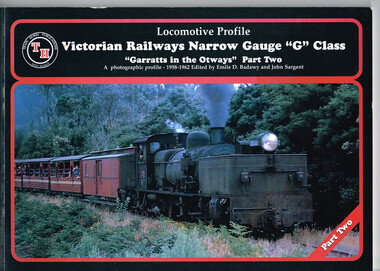
... Victorian Railways; narrow gauge; Emile D. Badawy; John Sargent; Victorian Railways Narrow Gauge "G" Class. "Garratts in the Otways" Part Two. A photographic profile - 1958-1962. Emile D. Badawy (ed.); John Sargent (ed.). 1999; Train Hobby Publications. ii, 56 p.; illus., map ...An historical series setting out Garratt engines and running stock running between Colac and Crowes (just past Lavers Hill), and then between Colac and Beech Forest in the Otways between 1958 and 1962 when the line closed.Victorian Railways Narrow Gauge "G" Class. "Garratts in the Otways" Part Two. A photographic profile - 1958-1962. Emile D. Badawy (ed.); John Sargent (ed.). 1999; Train Hobby Publications. ii, 56 p.; illus., map. Soft cover. colac; beech forest; crowes; garratt; victorian railways; narrow gauge; emile d. badawy; john sargent; -
 Otway Districts Historical Society
Book, Train Hobby Publications, Victorian Railways Narrow Gauge, Part 1, March 1998
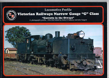
... Victorian Railway narrow gauge line from Colac to Crowes, and then from Colac to Beech Forest, in the Otways from 1954 until 1962 when the line closed. Colac; Beech Forest; Crowes; Victorian Railways; Garratt; narrow gauge; Emile D. Badawy; John Sargent; Victorian Railways Narrow Gauge "G" Class. "Garratts in the Otways" Part One. A photographic profile - 1954-1962. Emile D. Badawy (ed.); John Sargent (ed.). 1998; Train Hobby Publications; Studfield (Vic). ii, 48 p.; illus., maps ...The first in an historical series showing the Victorian Railway narrow gauge line from Colac to Crowes, and then from Colac to Beech Forest, in the Otways from 1954 until 1962 when the line closed.Victorian Railways Narrow Gauge "G" Class. "Garratts in the Otways" Part One. A photographic profile - 1954-1962. Emile D. Badawy (ed.); John Sargent (ed.). 1998; Train Hobby Publications; Studfield (Vic). ii, 48 p.; illus., maps. Soft cover.colac; beech forest; crowes; victorian railways; garratt; narrow gauge; emile d. badawy; john sargent; -
 Otway Districts Historical Society
Book, Focus on Beech Forest Line, Part Two, November 2006
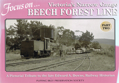
... Victorian Railways; narrow gauge; Beech Forest; Colac; Crowes; John E. Thompson; Edward A. Downs; railway; Focus on Victoria's Narrow Gauge Beech Forest Line, Part Two. A pictorial tribute to the late Edward A. Downs, Railway Historian. John E. Thompson. Puffing Billy Preservation Society; Belgrave (Vic); November 2006. iv, 42 p.; illus; maps ...In the earliest years of the Colac-Beech Forest-Crowes line all trains were hauled by NA-class 2-6-2 tank locomotives. From 1926, with the introduction of articulated Beyer Garrat locomotive G41, it hauled the majority of trains with the NA-class providing supplementary service as required. Late in 1945 G41 was out of action undergoing repairs at the depot in Colac so regular traffic again was handled by an NA-class for a short time before the Garratt returned. After this the line survived on pulpwood traffic long after the other narrow gauge lines had ceased regular operation until, on 30 June 1962, a dilapated G42 Garrett hauled the last train of goods wagons and vans to Beech Forest and return.Focus on Victoria's Narrow Gauge Beech Forest Line, Part Two. A pictorial tribute to the late Edward A. Downs, Railway Historian. John E. Thompson. Puffing Billy Preservation Society; Belgrave (Vic); November 2006. iv, 42 p.; illus; maps. Soft cover. ISBN 0 9579792 6 6victorian railways; narrow gauge; beech forest; colac; crowes; john e. thompson; edward a. downs; railway; -
 Otway Districts Historical Society
Book, Closed 50 Years Ago. Norman Houghton, 2012
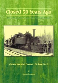
... railway was closed. The last goods train ran on 27 June 1962, and the last passenger excursion train on 30 June 1962. The railway was the lifeblood of the West Otways for several decades, enabling farmers and saw millers to bring into economic production the natural wealth of the region. Timber, butter, wool, livestock, potatoes, fodder and minerals flowed out for the benefit of Victorian consumers. colac; beech forest; weeaproinah; railway; Closed 50 years ago. The Colac to Beech Forest narrow guage railway. Commemorative booklet - 30 June 2012. Norman Houghton. Norman Houghton; Geelong (Vic); 2012. iv, 52 p.; illus., maps ...June 2012 represented 50 years since the Colac to Beech Forest to Weeaproinah narrow guage railway was closed. The last goods train ran on 27 June 1962, and the last passenger excursion train on 30 June 1962. The railway was the lifeblood of the West Otways for several decades, enabling farmers and saw millers to bring into economic production the natural wealth of the region. Timber, butter, wool, livestock, potatoes, fodder and minerals flowed out for the benefit of Victorian consumers.Closed 50 years ago. The Colac to Beech Forest narrow guage railway. Commemorative booklet - 30 June 2012. Norman Houghton. Norman Houghton; Geelong (Vic); 2012. iv, 52 p.; illus., maps. Soft cover.colac; beech forest; weeaproinah; railway; -
Port Melbourne Historical & Preservation Society
Flyer, Victorian Railways, Sandridge Rail Trail, 2005
... Port Melbourne Historical & Preservation Society Port Melbourne Town Hall 333 Bay Street Port Melbourne melbourne transport - railways recreation piers and wharves - station pier piers and wharves - railway pier hobson's bay railway company melbourne and hobson's bay united railway company montague street station golden fleece hotel st barnabas anglican church north port station lord raglan hotel Fold out flyer with black and white picture of train and three men on front cover. Back cover coloured image from Latrobe picture collection of park-like setting with steam train in background. Fold out section has history of railway, map, walk and ride descriptions Sandridge Rail Trail Flyer Victorian ...Fold out flyer with black and white picture of train and three men on front cover. Back cover coloured image from Latrobe picture collection of park-like setting with steam train in background. Fold out section has history of railway, map, walk and ride descriptionstransport - railways, recreation, piers and wharves - station pier, piers and wharves - railway pier, hobson's bay railway company, melbourne and hobson's bay united railway company, montague street station, golden fleece hotel, st barnabas anglican church, north port station, lord raglan hotel -
 Bendigo Historical Society Inc.
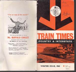
Book - RAILWAYS COLLECTION: TRAIN TIMES COUNTRY AND INTERSTATE WINTER ISSUE 1965
... RAILWAYS COLLECTION - Victorian Railways train times country and interstate - winter issue 1965 - as at May 3, 1965 price 6d - glossy cover in orange, black and white showing a Diesel train on the front. Back page has a fold out map...History House 11 Mackenzie Street Bendigo goldfields RAILWAYS Bendigo To Melbourne RAILWAYS COLLECTION - Victorian Railways train times country and interstate - winter issue 1965 - as at May 3, 1965 price 6d - glossy cover in orange, black and white showing a Diesel train on the front. Back page has a fold out map ...RAILWAYS COLLECTION - Victorian Railways train times country and interstate - winter issue 1965 - as at May 3, 1965 price 6d - glossy cover in orange, black and white showing a Diesel train on the front. Back page has a fold out map of rail routes.railways, bendigo to melbourne -
 Bendigo Historical Society Inc.
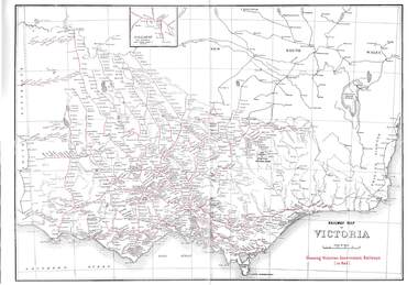
Map - RAILWAYS COLLECTION: 1946 RAILWAY MAP OF VICTORIA AUSTRALIA, 1946
... Railways Collection-1946 glossy paper Railway Map of Victoria Australia Reproduced courtesy of V/Line by the Railway Museum North Williamstown Victoria 1988 price 3 pence. The maps shown are Railway Map of Suburban Lines Melbourne and Railways map of Victoria Showing Victorian Government Railways in red....History House 11 Mackenzie Street Bendigo goldfields MAP Victoria Railways Collection-1946 glossy paper Railway Map of Victoria Australia Reproduced courtesy of V/Line by the Railway Museum North Williamstown Victoria 1988 price 3 pence. The maps shown are Railway Map of Suburban Lines Melbourne and Railways map of Victoria Showing Victorian Government Railways in red. ...Railways Collection-1946 glossy paper Railway Map of Victoria Australia Reproduced courtesy of V/Line by the Railway Museum North Williamstown Victoria 1988 price 3 pence. The maps shown are Railway Map of Suburban Lines Melbourne and Railways map of Victoria Showing Victorian Government Railways in red.map, victoria -
 Bendigo Historical Society Inc.
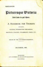
Book - PICTURESQUE VICTORIA
... railways, coaches, steamboats, fares, etc. Issued by the Victorian Railways December 1907. Printed by D W Paterson Co Melbourne, contains 246 pages with maps and black and white illustrations....railways, coaches, steamboats, fares, etc. Issued by the Victorian Railways December 1907. Printed by D W Paterson Co Melbourne, contains 246 pages with maps and black and white illustrations. ...Picturesque Victoria and how to get there, a handbook for tourists containing information regarding railways, coaches, steamboats, fares, etc. Issued by the Victorian Railways December 1907. Printed by D W Paterson Co Melbourne, contains 246 pages with maps and black and white illustrations.books, natural history, victoria -
 Bendigo Historical Society Inc.
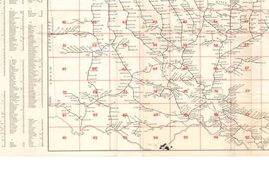
Document - RAILWAY MAP: VICTORIAN LINES 1973
... History House 11 Mackenzie Street Bendigo goldfields RAILWAYS Bendigo to melbourne Stations Railway map - Victorian lines 1973 with list of stations and grid reference for location of stations. Inset for detail of Ballarat and Melbourne lines and stations. Shows distance from Melbourne (Spencer Street station). Document RAILWAY ...Railway map - Victorian lines 1973 with list of stations and grid reference for location of stations. Inset for detail of Ballarat and Melbourne lines and stations. Shows distance from Melbourne (Spencer Street station).railways, bendigo to melbourne, stations -
 Bendigo Historical Society Inc.
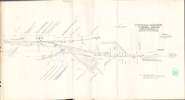
Document - BADHAM COLLECTION: VICTORIAN RAILWAYS MAP - NTH BENDIGO JUNCTION SIGNALLING DIAGRAM NO 4'80
... History House 11 Mackenzie Street Bendigo goldfields DOCUMENT Memo railway nth Bendigo junction signalling diagram no 4'80 Victorian railways map: Nth Bendigo junction signalling diagram no 480 showing signal and interlocking arrangements. Large paper map, A F chief electrical engineer 9.1.1980. Black ink diagram and writing. Document BADHAM COLLECTION: VICTORIAN RAILWAYS ...Victorian railways map: Nth Bendigo junction signalling diagram no 480 showing signal and interlocking arrangements. Large paper map, A F chief electrical engineer 9.1.1980. Black ink diagram and writing.document, memo, railway, nth bendigo junction signalling diagram no 4'80 -
 Bendigo Historical Society Inc.
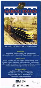
Document - BADHAM COLLECTION: VICTORIAN RAILWAYS- MAKING TRACKS BOOKLETS X 12
... Victorian Railways advertising brochures x 12. Glossy fold-out map and collage of old railway photos (without notations). ...History House 11 Mackenzie Street Bendigo goldfields BOOKS Magazines v/r advertising Victorian Railways advertising brochures x 12. Glossy fold-out map and collage of old railway photos (without notations). ...Victorian Railways advertising brochures x 12. Glossy fold-out map and collage of old railway photos (without notations). Articles include 'growing Victoria and various aspects of Railway life, celebrating 150 years of the Victorian Railways C 2004.books, magazines, v/r advertising -
Glenelg Shire Council Cultural Collection
Booklet - Booklet - South Western Victoria, n.d
... Victorian Railways. Contains black and white photos of cities and towns in the south west with a short description of each. Centre page full colour map of area. Blue cover, red print, image of man in bathers on a beach. Booklet Booklet - South Western Victoria Victorian Railways ...Forty-two page tourist brochure of South Western Victoria, produced by Victorian Railways. Contains black and white photos of cities and towns in the south west with a short description of each. Centre page full colour map of area. Blue cover, red print, image of man in bathers on a beach.Front: 'B.W. Vivian', ink, faded -
Glenelg Shire Council Cultural Collection
Flyer - Flyer - Portland, Victoria, Oct-38
... Victorian Railways. Contains several black and white photos of Portland, front cover red print, blue stylised bird and sea. Back cover has tourist map of Portland and District Flyer Flyer - Portland, Victoria Victorian Railways Print ...Single page flyer, folded 4 times. Tourist information for Portland, issued by Publicity and Tourist Services, Victorian Railways. Contains several black and white photos of Portland, front cover red print, blue stylised bird and sea. Back cover has tourist map of Portland and District -
 Federation University Historical Collection
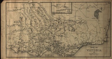
Map, Railway Map of Victoria, 1930
... map...railway...train-lines...victoria...Victorian Railways...Barker Library (top floor) Mount Helen goldfields map railway train-lines victoria Victorian Railways railway lines Cardboard map of Victorian railway system in 1930. ...Cardboard map of Victorian railway system in 1930. Maps out all train-lines in Victoria and into New South Wales. map, railway, train-lines, victoria, victorian railways, railway lines -
 Ballarat Tramway Museum
Magazine, Australian Railway and Locomotive Historical Society, "ARLHS Bulletin", 1943
... Railway and Locomotive Historical Society Bulletins for the period Jan 1943 to December 1943. Each page has been stencil duplicated. Index sheets for the journals at the front of the documents. March 1943 - pages 29 to 32 has an article "The Tramways of Bendigo - Bendigo Tramway Company Limited" written by Wal Jack. Has a large full page map prepared by C. C. Singleton. March 1943 - page 40 - has a short item on the St Kilda Brighton Tramway - three new tramcars (VR type). Item from the Journal of Victorian Model Railway...Railway and Locomotive Historical Society Bulletins for the period Jan 1943 to December 1943. Each page has been stencil duplicated. Index sheets for the journals at the front of the documents. March 1943 - pages 29 to 32 has an article "The Tramways of Bendigo - Bendigo Tramway Company Limited" written by Wal Jack. Has a large full page map prepared by C. C. Singleton. March 1943 - page 40 - has a short item on the St Kilda Brighton Tramway - three new tramcars (VR type). Item from the Journal of Victorian Model Railway Society" July 1943 - page 1 to 4, has an article "The Tramways of Geelong" - author not given, though probably largely Wal Jack. Has a large full page map prepared by C. C. Singleton. The Jan to June issues are loose, while the July to December issues have been hole punched and held together with a metal binder. "ARLHS Bulletin" Magazine Australian Railway ...Yields information about the tramways of Bendigo and the Geelong tramways and has a strong association with well known tramway enthusiasts of the era., Yields information about the tramways of Bendigo and the Geelong tramways and has a strong association with well known tramway enthusiasts of the era.Set of 12 Australian Railway and Locomotive Historical Society Bulletins for the period Jan 1943 to December 1943. Each page has been stencil duplicated. Index sheets for the journals at the front of the documents. March 1943 - pages 29 to 32 has an article "The Tramways of Bendigo - Bendigo Tramway Company Limited" written by Wal Jack. Has a large full page map prepared by C. C. Singleton. March 1943 - page 40 - has a short item on the St Kilda Brighton Tramway - three new tramcars (VR type). Item from the Journal of Victorian Model Railway Society" July 1943 - page 1 to 4, has an article "The Tramways of Geelong" - author not given, though probably largely Wal Jack. Has a large full page map prepared by C. C. Singleton. The Jan to June issues are loose, while the July to December issues have been hole punched and held together with a metal binder.museums bendigo, vr trams, geelong -
 Ballarat Tramway Museum
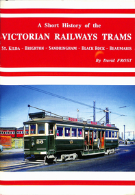
Book, David Frost, "A short history of the Victorian Railways Trams - St Kilda - Brighton - Sandringham - Black Rock - Beaumaris", May. 2006
... Victorian Railways Trams - St Kilda - Brighton - Sandringham - Black Rock - Beaumaris". Covers have colour photographs on the outside. Page 11 has a map of the two tramways with the tram lines and features shown in red. Written by David Frost, published May 2006 by Tramway Publications. Edited by Dean Filgate. Provides details of the background of the tramways, Elwood depot fire, Sandringham depot, closure and an Epilogue Has details of the Author. "A short history of the Victorian Railways ...Book - 20 pages + card covers, centre stapled titled "A short history of the Victorian Railways Trams - St Kilda - Brighton - Sandringham - Black Rock - Beaumaris". Covers have colour photographs on the outside. Page 11 has a map of the two tramways with the tram lines and features shown in red. Written by David Frost, published May 2006 by Tramway Publications. Edited by Dean Filgate. Provides details of the background of the tramways, Elwood depot fire, Sandringham depot, closure and an Epilogue Has details of the Author.trams, tramways, vr trams, elwood, st kilda brighton, sandringham, beaumaris