Showing 12950 items matching "maps "
-
 Melbourne Tram Museum
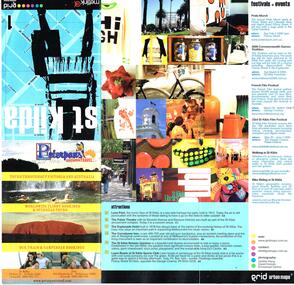
Pamphlet, Grid Urban Maps, "St Kilda grid urban maps", mid 2000's
... "St Kilda grid urban maps"...... Maps...Published by Grid Urban Maps - www.gridmaps.com.au - not functioning at 15/1/2019....Grid Urban Maps..."St Kilda grid urban maps" Pamphlet Grid Urban Maps ...Pamphlet - 12 fold sheet, full colour, titled "St Kilda grid urban maps" showing a map of St Kilda area, public transport routes, locations, description of attractions, festivals, events, and retail and food outlets with a small entry for each advertiser. Has Metlink logo. Published by Grid Urban Maps - www.gridmaps.com.au - not functioning at 15/1/2019.trams, tramways, st kilda, maps, events, public transport -
 Ringwood and District Historical Society
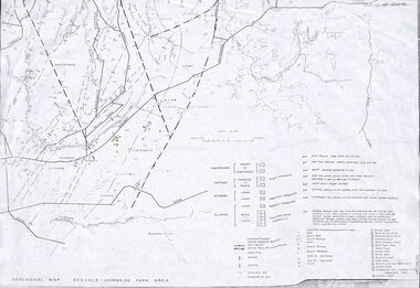
Map - Maps, Geological Map Donvale to Chirnside Park, also Victorian Railways Maps of Hawthorn to Lilydale Line incl Ringwood to East Ringwood - 1881
... Maps...Geological Map Donvale to Chirnside Park, also Victorian Railways Maps of Hawthorn to Lilydale Line incl Ringwood to East Ringwood - 1881...Map...Faint photocopies of sections of larger maps. Geological map includes location of mine shafts circa 1920....Geological Map Donvale to Chirnside Park, also Victorian Railways Maps of Hawthorn to Lilydale Line incl Ringwood to East Ringwood - 1881 Map Maps ...Faint photocopies of sections of larger maps. Geological map includes location of mine shafts circa 1920.Victory Shaft, North Victory Shaft, South Caledonia Shaft, Caledonia Shaft, North Caledonia Shaft, Black Swan Shaft, Reward Shaft, Consols Shaft, Blocks Shaft, Devonshire Shaft, Crown Shaft, Yarra Tunnel Reef Working, Bright's Shaft, Kingwood Antimony Company Shaft (Boardman's Shaft), Southern Shaft. -
 Buninyong Visitor Information Centre
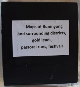
Document (item) - Information Folder, Maps of Buninyong and Surrounding Districts, 1990s
... Maps of Buninyong and Surrounding Districts...Maps...Collection of maps and copies of maps of the Buninyong district....Black vinyl covered ring binder with plastic pockets containing maps and historical articles....Buninyong Visitor Information Centre 408 Warrenheip Street Buninyong goldfields Collection of maps and copies of maps of the Buninyong district. ...Collection of maps and copies of maps of the Buninyong district.maps, mapping, buninyong -
 Bacchus Marsh & District Historical Society
Map, Bacchus Marsh Township and Nearby Districts Maps Volume
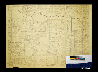
... Bacchus Marsh Township and Nearby Districts Maps Volume...Maps...Map...This volume of maps is believed to have been compiled by staff at the Shire of Bacchus Marsh and was presumably used to inform and assist Shire staff and Councillors in the carriage of their duties....There are 81 maps in total. Map 1 Liquidators Sale 1896. ...Map 2. Woodside Estate Sale 1913. Bacchus Marsh Township and Nearby Districts Maps Volume Map ...This volume of maps is believed to have been compiled by staff at the Shire of Bacchus Marsh and was presumably used to inform and assist Shire staff and Councillors in the carriage of their duties.This collection of maps are significant due to their rarity as many of them are unique maps made for local purposes in the Bacchus Marsh region. They are also of strong research value containing a wide variety of information including landholders, land sales, infrastructure, such as roads, bridges, public, commercial and private buildings, houses, land use, and geographic features over multiple decades from the late nineteen century into the middle part of the twentieth century.One bound volume of maps comprising cadastral maps, (indicating property owners and land boundaries), land plans and real estate auction plans and advertising material, and other maps indicating major infrastructure like proposed roads and irrigation areas. Most of the maps and plans are of Bacchus Marsh and nearby areas but some maps are of nearby towns such as Melton, Ballan and Blackwood. The volume comprises 52 pages. Most pages have a single map or plan pasted onto it but some contain 2 or 3 different maps. There are 81 maps in total. Map 1 Liquidators Sale 1896. Map 2. Woodside Estate Sale 1913. maps, maps bacchus marsh, maps bacchus marsh region -
 Whitehorse Historical Society Inc.
Map, Directory Maps of the County of Bourke, 1892
... Map...Directory Maps of the County of Bourke...Maps...Map...Bonney for the Victorian Shire Map Company. Scale: 40 chains to the inch....Directory maps of the County of Bourke, containing all the Parishes ... also a complete map of the Colony of Victoria, showing all the Counties, Parishes, Railways and stations to date, and the Mallee Blocks. ...Directory Maps of the County of Bourke Map Map ...Directory maps of the County of Bourke, containing all the Parishes ...Directory maps of the County of Bourke, containing all the Parishes ... also a complete map of the Colony of Victoria, showing all the Counties, Parishes, Railways and stations to date, and the Mallee Blocks. Lithographed by G.S.B. Bonney for the Victorian Shire Map Company. Scale: 40 chains to the inch.Directory maps of the County of Bourke, containing all the Parishes ...maps, victoria. county of bourke, t.r.b. morton & son -
 Lara RSL Sub Branch
Group of Maps World War One, Group of Maps World War One - Dardanelles and Anzac Gallipoli Maps Circ 1915, Circ 1916
... Group of Maps World War One - Dardanelles and Anzac Gallipoli Maps Circ 1915...Gallipoli 1915 Maps and Naval plan of Operations World War One ANZAC...Black & White 6. Color Map of ANZAC positions with topographical Details, notes. ...Australian War Memorial, 6. Map of ANZAC positions of World War One, Gallipoli 1915. ...Group of Maps World War One - Dardanelles and Anzac Gallipoli Maps Circ 1915 Group of Maps World War One ...Gallipoli 1915 Maps and Naval plan of Operations World War One ANZACRare examples that explain both ANZAC and Naval Operations during World War One Gallipoli & Dardanelles Passage .!. Black and White Photocopy of Gallipoli 1915 ANZAC Battlefield - detailed positions of troops and Cemeteries. 2.The Allied Failure to Force The Dardanelles Passage 18 March 1915 - detailed line of Attack Naval Organisation, Mine layout, Plan of Attack (and copy).. 3. Map of Turkey and surrounding area written in Turkish and German Languages. C0olor version main roads and distances. (and copy).. 4. Map of ANZAC Trench Diagram. World War One.Color. (and copy). 5.Panorama of Chunuk Blair from 3 miles south of Nibrunesi Point, 3 November 1915 and Anzac from 1 mile N. E. of Ari Burnu, 21 November 1915. Black & White 6. Color Map of ANZAC positions with topographical Details, notes. 1. Artwork and copyright by Srewart Cownie, Gallipoli 1915 ANZAC Battlefield with Landings and later evacuation marked. 2. Details of Naval actions taken in the Dardanelles Passage 18 March 1918. 3. Local area Map or Turkey. Shows roads network and townships. 4. ANZAC Trench Diagram, copyright Whitcombe & Tombs Limited , Wellington N.Z. 1919 5. Panorama of two coast views of ANZAC area. Australian War Memorial, 6. Map of ANZAC positions of World War One, Gallipoli 1915. Published by H.E.C. Roberinson, George Street, Sydney N.S.W.18 April 1916maps operational of anzac and naval opations during 1915 etc, dardanelles naval opations -
Lara RSL Sub Branch
Silk Maps, Four Collective maps
... Four Collective maps...Map 1....Silk Fabric ... "Western Pacific.Map 2....Silk fabric....Hong Kong /Canton.Map 3Cloth Map East Java South West Pacific.Map 4....Arakan/Irrawaddy fabric map.M...Map 4....Restricted..Edition 1 -gsgsFabric Map 1;1,000,000 Map 3....No 25 Timor/No 26 East Java .Map 2 Hong Kong/Canton restricted MAP 1,NACI - HO. ...Lara RSL Sub Branch McClelland Ave Lara Scientific or research signifigance. Map 4....Restricted..Edition 1 -gsgsFabric Map 1;1,000,000 Map 3....No 25 Timor/No 26 East Java .Map 2 Hong Kong/Canton restricted MAP 1,NACI - HO. ...Scientific or research signifigance.Map 1....Silk Fabric ... "Western Pacific.Map 2....Silk fabric....Hong Kong /Canton.Map 3Cloth Map East Java South West Pacific.Map 4....Arakan/Irrawaddy fabric map.MMap 4....Restricted..Edition 1 -gsgsFabric Map 1;1,000,000 Map 3....No 25 Timor/No 26 East Java .Map 2 Hong Kong/Canton restricted MAP 1,NACI - HO. No.S 12. -
 Buninyong Visitor Information Centre
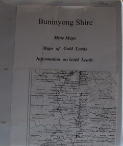
Document (item) - Information Folder, Buninyong Visitor Information Centre Volunteers, Buninyong Shire Mine Maps, 1990s
... Buninyong Shire Mine Maps......Maps...Refer to the photographs of the contents pages for the list of the sixty-one maps in this folder. Maps are not originals and were copied for research purposes only. ...White vinyl covered ring binder with plastic pockets containing copies of maps and gold leads in the Buninyong area....Gold Mining Mines Maps Buninyong Gold Leads Mining Companies White vinyl covered ring binder with plastic pockets containing copies of maps and gold leads in the Buninyong area. ...Refer to the photographs of the contents pages for the list of the sixty-one maps in this folder. Maps are not originals and were copied for research purposes only. gold, mining, mines, maps, buninyong, gold leads, mining companies -
 Ballarat Tramway Museum
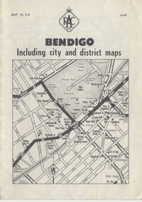
Map, Royal Automobile Club of Victoria, "Bendigo Including city and district maps - RACV", c1968
... "Bendigo Including city and district maps - RACV"...... Map...Map...Printed street map titled "Bendigo Including city and district maps", published by the RACV, showing the central part of Bendigo on the front cover, Bendigo Outlets and notes on the city itself. ...in ink on the Bendigo Outlet map, has various notes showing the location of crossing loops on and off the map and the location of the tram depot itself...."Bendigo Including city and district maps - RACV" Map Royal Automobile Club of Victoria ...Printed street map titled "Bendigo Including city and district maps", published by the RACV, showing the central part of Bendigo on the front cover, Bendigo Outlets and notes on the city itself. Has the tram lines shown dotted, only shows the full extent of the Golden Square line. Inside has a district road map. The front cover has the number "0468" in the bottom left hand corner, indicating the publication date.in ink on the Bendigo Outlet map, has various notes showing the location of crossing loops on and off the map and the location of the tram depot itself.trams, tramways, map, bendigo, racv, railways -
Warrnambool and District Historical Society Inc.
Map (series) - Local Parish Maps, Local Government maps 1942 and three fire maps
... Local Government maps 1942 and three fire maps....Map...The fire maps would have been used by CFA to locate areas of fire problems . ...The fire maps are South and North regions....Map Local Parish Maps. ...These show the Western District in detail with property owners named . The fire maps have properties which are numbered.western district maps, belfast, brucknell, caramut, cooramook, framlingham east, framlingham west, garvoc, laang, kangertong, meerai, minjah north, minjah, minhamite, nullawarre, narrawaturk, nirranda, paaratte, panmure, purnim, quamby north, tallangatta, quamby, timboon, wangoom, willatook, woolsthorpe, yangery, yarpturk, ecklin, yeth- youang.western district maps, belfast, brucknell, caramut, cooramook, framlingham east, framlingham west, garvoc, laang, kangertong, meerai, minjah north, minjah, minhamite, nullawarre, narrawaturk, nirranda, paaratte, panmure, purnim, quamby north, tallangatta, quamby, timboon, wangoom, willatook, woolsthorpe, yangery, yarpturk, ecklin, yeth- youang. -
 Sunshine and District Historical Society Incorporated
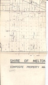
Map - Maps
... Maps...Map...Map...Collection of maps...2295.01 - Map Shire of Melton Composite Property Map 2295.02 - Map Parish of Tullamarine with property owners 2295.03 - Map Parish of Maribyrnong with property owners 1892 2295.04 - Map District map of Melton Bulla Keilor Broadmeadows Essendon Sunshine Footscray Altona and Williamstown 2295.05 - Map Riverside Projects Masterplan...Map 2295.01 - Map Shire of Melton Composite Property Map 2295.02 - Map Parish of Tullamarine with property owners 2295.03 - Map Parish of Maribyrnong with property owners 1892 2295.04 - Map District map of Melton Bulla Keilor Broadmeadows Essendon Sunshine Footscray Altona and Williamstown 2295.05 - Map Riverside Projects Masterplan Collection of maps Map Maps ...2295.01 - Map Shire of Melton Composite Property Map 2295.02 - Map Parish of Tullamarine with property owners 2295.03 - Map Parish of Maribyrnong with property owners 1892 2295.04 - Map District map of Melton Bulla Keilor Broadmeadows Essendon Sunshine Footscray Altona and Williamstown 2295.05 - Map Riverside Projects Masterplanmap -
 City of Moorabbin Historical Society (Operating the Box Cottage Museum)
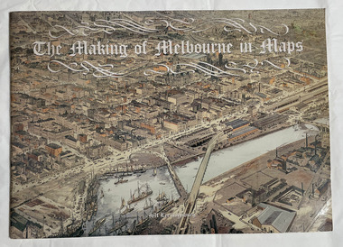
Book, Leeuwenburg, Jeff, The making of Melbourne in maps, 1987
... The making of Melbourne in maps...maps...1 atlas (57 p.) : ill., chiefly maps ;...City of Moorabbin Historical Society (Operating the Box Cottage Museum) Joyce Park Jasper Road Ormond melbourne maps Melbourne Cartographic material. 1 atlas (57 p.) : ill., chiefly maps ; The making of Melbourne in maps Book Leeuwenburg, Jeff Longman Cheshire ...Cartographic material.1 atlas (57 p.) : ill., chiefly maps ;Cartographic material.maps, melbourne -
Whitehorse Historical Society Inc.
Map, Directory Maps of the County of Bourke, 1892
... Map...Directory Maps of the County of Bourke...Maps...Map...(i) Title Page, (ii) Preface (iii) Heading section of Map of Melbourne and Suburbs (iv) Parish of Bulleen - includes 'North - East portion of the Parish of Nunawading (v) Village of Burwood. ...Copies of:(i) Title Page, (ii) Preface (iii) Heading section of Map of Melbourne and Suburbs (iv) Parish of Bulleen - includes 'North - East portion of the Parish of Nunawading (v) Village of Burwood. ...Note: 107(a), 107(b), 107(c) are copies of the same set of sheets. Directory Maps of the County of Bourke Map Map ...Copies of Directory maps:(i) Title Page, (ii) Preface (iii) Heading section of Map of Melbourne and Suburbs (iv) Parish of Bulleen - includes 'North - East portion of the Parish of Nunawading (v) Village of Burwood. Note: 107(a), 107(b), 107(c) are copies of the same set of sheets.Copies of:(i) Title Page, (ii) Preface (iii) Heading section of Map of Melbourne and Suburbs (iv) Parish of Bulleen - includes 'North - East portion of the Parish of Nunawading (v) Village of Burwood. Note: 107(a), 107(b), 107(c) are copies of the same set of sheets.Copies of Directory maps:(i) Title Page, (ii) Preface (iii) Heading section of Map of Melbourne and Suburbs (iv) Parish of Bulleen - includes 'North - East portion of the Parish of Nunawading (v) Village of Burwood. Note: 107(a), 107(b), 107(c) are copies of the same set of sheets.maps, parish of bulleen, parish of nunawading, burwood -
University of Melbourne, Burnley Campus Archives
Plan, Maplist: Catalogue of Victorian maps, 1984
... Maplist: Catalogue of Victorian maps...maps...Brochure showing all standard series mapping in Victoria available from Map Sales Centre as at October 1984. Includes: Geographic, Geological Planimetric, Aerial Photography, Photo Maps....Includes: Geographic, Geological Planimetric, Aerial Photography, Photo Maps. Maplist: Catalogue of Victorian maps Plan ...Brochure showing all standard series mapping in Victoria available from Map Sales Centre as at October 1984. Includes: Geographic, Geological Planimetric, Aerial Photography, Photo Maps.maps, catalogue -
Whitehorse Historical Society Inc.
Document, Historical maps and plans, 1855 1889
... Historical maps and plans...Maps...Copy of catalogue of historical maps and plans - Crown Lands Department...Whitehorse Historical Society Inc. 2-10 Deep Creek Road Mitcham melbourne Maps Historical maps Copy of catalogue of historical maps and plans - Crown Lands Department Copy of catalogue of historical maps and plans - Crown Lands Department Historical maps and plans Document Document ...Copy of catalogue of historical maps and plans - Crown Lands DepartmentCopy of catalogue of historical maps and plans - Crown Lands DepartmentCopy of catalogue of historical maps and plans - Crown Lands Departmentmaps, historical maps -
 Phillip Island and District Historical Society Inc.
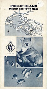
Map, Phillip Island District and Town Maps, 01/11/1967
... Phillip Island District and Town Maps ...Map...Map - PI District and Town Maps - Tourist brochure. ...Map-Phillip Island and District Maps - Tourist guide to Phillip Island tourist sites. ...Map - PI District and Town Maps - Tourist brochure. ...Map - PI District and Town Maps - Tourist brochure. Produced by the RSCV.HistoricalMap-Phillip Island and District Maps - Tourist guide to Phillip Island tourist sites. A3 page folded as a brochure. Blue print and photographs and advertisements.historical society -
 Melbourne Tram Museum
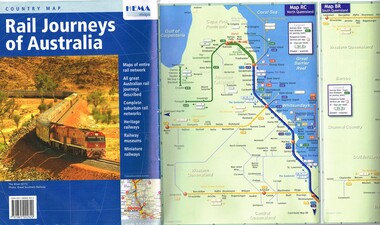
Map, HEMA Maps, "Rail Journeys of Australia", 2011
... ... Maps...Map...Published by HEMA Maps. Includes a combined diagrammatic map of Melbourne suburban railway and tramways and ferries. ...HEMA Maps..."Rail Journeys of Australia" Map HEMA Maps ...Map - 16 fold full colour gloss paper titled "Rail Journeys of Australia", published 2011m diagrammatic maps of the Australian rail network, complete suburban rail and tram networks, heritage railways, railway museums and miniature railways. Has a photo of The Ghan on the front. Published by HEMA Maps. Includes a combined diagrammatic map of Melbourne suburban railway and tramways and ferries. Has a note on the frequency and fares. Received during 2011 as a with compliments slip and asking if needed more. Slip gives the publishers details.trams, tramways, maps, australian railways, trams, melbourne -
 Ballarat Tramway Museum
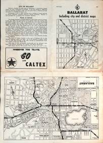
Map, RACV - Royal Automobile Club of Victoria, "Ballarat including city and district maps", 10/1961
... "Ballarat including city and district maps"...Map...Map...Each map in the bottom left-hand corner has the number "1061", possibly indicating the date. ...Four fold map printed on white paper, titled "Ballarat including city and district maps" - Map No. ...MAP 15.314 and dated 10-61. Produced by the RACV "Ballarat including city and district maps" Map RACV - Royal Automobile Club of Victoria ...Shows the central part of Ballarat, Ballarat Outlets, streets, principal attractions, Ballarat and district maps and information. Has the tram lines shown dotted, does not run out to Sebastopol or the Lydiard St North terminus. Each map in the bottom left-hand corner has the number "1061", possibly indicating the date. Has notes on the City, points of interest, and an advertisement for Caltex. See item 4929 for a larger version dated 1966. Yields information about the extent of Ballarat in the early 1960's shows the tram lines and other rail lines in the district. Four fold map printed on white paper, titled "Ballarat including city and district maps" - Map No. MAP 15.314 and dated 10-61. Produced by the RACVmap, tranways, ballarat, racv, railways -
 Lara RSL Sub Branch
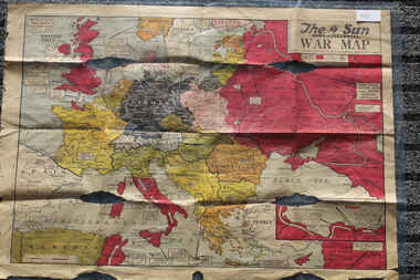
Newspaper - The Sun Newspaper Dated 5/8/1944 -specia - World War 2 Europe Map and History Of World War 2 and Nazi Tide Flows and Ebbs Across Europe, THe Sun Newspaper Dated 5/8//1944 - Special War Maps
... THe Sun Newspaper Dated 5/8//1944 - Special War Maps...Local Newspaper Dated 5/8/1944 - Special World War 2 Maps... World War 2 Europe Map and History Of World War 2 and Nazi Tide Flows and Ebbs Across Europe...Lara RSL Sub Branch McClelland Ave Lara The Sun Newspaper Dated 5/8/1944 world war 2 europe map and hisytory of world war 2 and nazi tide flows and ebbs across europe World War 2 Europe Map and History Of World War 2 and Nazi Tide Flows and Ebbs Across Europe Local Newspaper Dated 5/8/1944 - Special World War 2 Maps THe Sun Newspaper Dated 5/8//1944 - Special War Maps Newspaper The Sun Newspaper Dated 5/8/1944 -specia - World War 2 Europe Map and History Of World War 2 and Nazi Tide Flows and Ebbs Across Europe ...The Sun Newspaper Dated 5/8/1944 Local Newspaper Dated 5/8/1944 - Special World War 2 Maps World War 2 Europe Map and History Of World War 2 and Nazi Tide Flows and Ebbs Across Europeworld war 2 europe map and hisytory of world war 2 and nazi tide flows and ebbs across europe -
 Lara RSL Sub Branch
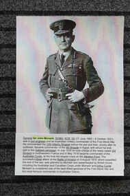
Work on paper - Internet research for World War 1 - Pictures and Maps 1918, World War 1 - Pictures and Maps 1918
... World War 1 - Pictures and Maps 1918...Internet Research printouts of World War 1 details - General Sir John Monash portrait, Maps of Battles etc...General Sir Jon Monash portrait and details of service, Maps of Battles of Wold War 1 1918 ...Lara RSL Sub Branch McClelland Ave Lara Internet Research material Relevant research material 1918 World War 1 world war 1 - 1918 internet research printed material australian at war 1918 General Sir Jon Monash portrait and details of service, Maps of Battles of Wold War 1 1918 Internet Research printouts of World War 1 details - General Sir John Monash portrait, Maps of Battles etc World War 1 - Pictures and Maps 1918 Work on paper Internet research for World War 1 - Pictures and Maps 1918 ...Internet Research materialRelevant research material 1918 World War 1Internet Research printouts of World War 1 details - General Sir John Monash portrait, Maps of Battles etcGeneral Sir Jon Monash portrait and details of service, Maps of Battles of Wold War 1 1918 world war 1 - 1918 internet research printed material australian at war 1918 -
 Eltham District Historical Society Inc
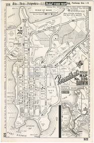
Document - Folder, Survey Maps and Technical Drawings
... Survey Maps and Technical Drawings......Maps...Pocket Card Map: Broadbent’s Official Map No. 326 Darwin 2. ...Pocket Card Map: Broadbent’s Official Map No. 326 Darwin 2. ...alan gardiner collection, maps -
 Melbourne Tram Museum
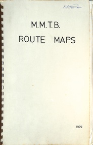
Map, Melbourne & Metropolitan Tramways Board (MMTB), MMTB Route Maps, 1979
... MMTB Route Maps......maps...Map...Series of colour maps for various tram and bus routes, dated 1979. ...Book - brown comb binding, card and clear plastic covers containing both bound and unbound maps and documents....Book - brown comb binding, card and clear plastic covers containing both bound and unbound maps and documents. MMTB Route Maps Map Melbourne & Metropolitan Tramways Board (MMTB) ...Series of colour maps for various tram and bus routes, dated 1979. Also contained, not scanned are letters, reports, and specifications for printing these maps for use in shelters etc. Some have the Transport Information Centre telephone printed on them. Some are finished with a plastic laminate finish on either one or both sides. Show the major cross streets, parks, schools, other tram routes, major stop numbers, and railway lines. See also item 3909 for another example of these. Trams 1 - City route guide - R9/77 - showing all route numbers and destinations that passed through the CBD. 2 - Bourke St tram routes - R4/77 - East Brunswick Blyth St and East Preston Tyler St and intermediate routes, routes 95, 96, 97, 90, 89 and 88. 3 - Malvern, East Malvern, Carnegie, and East Brighton Tram Routes (from St Kilda Junction) - R1/79 - shows routes 5, 3, 67, 66, 61, 62, and 64. 4 - Elizabeth St tram routes - R12/77 - Essendon Airport, West Maribyrnong, North Coburg lines, routes 50, 58, 60, 54, 57, 52. 49, 59, 18, 20 and 19 5 - Flinders St tram routes - R5/78 - North Balwyn, East Burwood, routes 48, 40, 41, Hartwell, 28, 74 and 75 6 - Kew - St Kilda Beach - R1/79 - Route 69. 7 - Mont - Albert City - R11/77, shows routes 43. 47. 45. 44 8 - St Kilda Rd Tram Routes R12/77 - details South Melbourne Beach, route 1 and route 2 and St Kilda Beach routes 15, 16, and 55 otherwise shows where the various routes branch off St Kilda Road 9 - Batman Ave tram routes - R9/77 - Wattle Park, North Richmond and Prahran - routes 70, 71, 78 and 79. 10 - Footscray - Moonee Ponds - R3/81 - Route 82 11 - Swanston St tram guide - R1/79 - lists all routes and route numbers that branch or cross Swanston St between Grattan St and St Kilda Junction. 12 - Toorak Camberwell and Glen Iris tram route with Camberwell Junction and Malvern Town Hall, R1/79, routes 8, 7, 6, 72, and 73 shown. 13 - West Preston - Beach tram routes - R12/77 - routes 10, 11, 9 and 12, 14 - William St tram routes - R12/77 - Route 55, 56, and 63 - South Melbourne Depot and Domain. Buses 1 - Footscray, Sunshine, Deer Park, Nth Altona & Fishermans Bend - R2/79 2 - Box Hill bus routes to Templestowe, Heidelberg & East Kew - R6/78 - notes superseded by R3/82 3 - Plan of Russell St Melbourne bus departure bays. 4 - Box Hill, Mitcham & Ringwood bus routes to East Doncaster & Warrandyte - R3/82 5 - City - Warrandyte & East Doncaster bus routes - R3/82 & R6/78 6 - Bulleen - City - Port Melbourne - Garden City Bus route - R6/78 7 - North Altona - City bus route - 11/78 8 - Clifton Hill - Elsternwick - R2/79 9 - La Trobe - Northland - West Heidelberg - City Bus Service via East Freeway - 11/79 and R3/81 10 - Box Hill, Mitcham & Ringwood Bus Routes to East Doncaster & Warrandyte - R10/84 - with the Metropolitan Transit logo.Yields information about tram and bus routes in late 1970s early 1980s.Book - brown comb binding, card and clear plastic covers containing both bound and unbound maps and documents.K C Painter on front cover in ink.tramways, mmtb, tram routes, maps, bus routes, route numbers, routes, route guide -
 Whitehorse Historical Society Inc.
Map - Civic maps, City of Nunawading, City of Nunawading Maps
... City of Nunawading Maps...Map...The City of Nunawading existed from 1925 to 1994. The maps show its residential holdings. They are undated but likely to have been used just before the City was abolished in 1994. ...8 printed maps of various sizes covering city of Nunawading. ...Scale 1:2500 City of Nunawading Maps Map Civic maps City of Nunawading ...A collection of maps of the City of Nunawading from Diana Coles, City of Whitehorse Community Chest.8 printed maps of various sizes covering city of Nunawading. Scale 1:2500non-fictionA collection of maps of the City of Nunawading from Diana Coles, City of Whitehorse Community Chest. coles diana, civic maps, city of nunawading, whitehorse road, blackburn road -
 Federation University Historical Collection
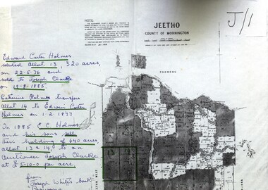
Map - Documents, Documents relating to Land - Selection of Maps of subdivisions; Titles; Cemetery sections
... Documents relating to Land - Selection of Maps of subdivisions; Titles; Cemetery sections...Map...Maps indicate the land owned in various areas of Victoria - Mornington Peninsula, Ascot / Creswick area...Land maps showing block divisions and owners. Edward Carter Holmes J.P. selected land and called it Launchley - later called Wambalano....Documents relating to Land - Selection of Maps of subdivisions; Titles; Cemetery sections Map Documents ...Maps indicate the land owned in various areas of Victoria - Mornington Peninsula, Ascot / Creswick areaLand maps showing block divisions and owners. Edward Carter Holmes J.P. selected land and called it Launchley - later called Wambalano.jeetho, county of mornington, edward carter holmes, joseph clarke, catherine holmes, talbot, william coghill, pre-emptive right, tourello pre-emptive right, glendonald pre-emptive right, clunes, smeaton, ascot, counties of ripon and talbot, certificate of title, ballaarat general cemetery, new cemetery, poowong, helen coghill -
 Victorian Aboriginal Corporation for Languages
Map, Country Fire Authority, Region 15 rural directory : Ballarat &? Midlands Area : fully detailed maps &? roads index of Ballarat &? the developing areas surrounding, 1996
... Map...Midlands Area : fully detailed maps &? roads index of Ballarat &? the developing areas surrounding...maps...Midlands Area : fully detailed maps &? roads index of Ballarat &? the developing areas surrounding Map Country Fire Authority ...mapsballarat, fire protection, victorian regional maps, emergency services -
 Victorian Aboriginal Corporation for Languages
Map, Country Fire Authority, Region 2 rural directory : Bendigo &? North Central Victoria: fully detailed maps &? roads index of Bendigo &? the developing areas surrounding, 1996
... Map...North Central Victoria: fully detailed maps &? roads index of Bendigo &? the developing areas surrounding...maps...North Central Victoria: fully detailed maps &? roads index of Bendigo &? the developing areas surrounding Map Country Fire Authority ...mapsbendigo, loddon, fire protection, victorian regional maps, directories -
Creswick Campus Historical Collection - University of Melbourne
Maps, 1967 - 1972
... Maps...Maps of various subjects: Gunbower Island 1972. ...Maps...Gilwell & Beenak. Maps Maps ...Maps of various subjects: Gunbower Island 1972. Barmah Forest 1967. Survey maps from aerial photography 1971 _Narnargoon.Tonimbuk. Gilwell & Beenak.Maps -
 City of Moorabbin Historical Society (Operating the Box Cottage Museum)
Map - Maps, T. H. Putt Real Estate Bentleigh, c 1940's
... Maps......maps...Map...A local Real Estate agent, T. H. Putt used the maps to assist with the selling of the subdivisions of market gardens of the City of Moorabbin....The maps in the book were most likely from the maps produced in the mid 1930’s. ...Putt Real Estate Bentleigh Map Maps ...The train line from the city to Frankston was electrified in 1922 which intensified the sale in the municipality of Moorabbin, particularly land which was in the vicinity of the railway stations. A local Real Estate agent, T. H. Putt used the maps to assist with the selling of the subdivisions of market gardens of the City of Moorabbin. Example of the progress of the Municipality of MoorabbinA black folder containing 29 pages of maps of the suburbs of the City of Moorabbin. The maps are sections of Melbourne and Metropolitan Board of Works (MMBW) plans which were produced from the 1890s to the 1950s. These maps were used to the design and development of Melbourne's sewerage and drainage system. The maps in the book were most likely from the maps produced in the mid 1930’s. Some of the MMBW maps have had extra subdivisions and information, such as measurements, owners names, and street names have been added. There are four maps which have been hand drawn and cover the part of East Bentleigh bordered by East Boundary Road, Centre Road, Warrigal Road and South Road. At the time this area was still market gardens. The maps have been mounted on material by J. Creffield Pty Ltd, 171 King Street, Melbourne Victoria. Creffield Pty Ltd, was a firm of map mounters, heliographers and printers, which commenced business in 1988. The company still operates today (2025) in West Melbourne as Creffield Digital Print. putt, real estate, moorabbin, bentleigh, bentleigh east, cheltenham, hampton, brighton, mckinnon, mmbw, melbourne metropolitan board of works, maps, t. h. putt -
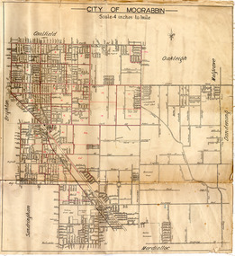
![Map - Maps, [John Batman in Melbourne], 1976](/media/collectors/4f729f5697f83e03086015b8/items/60965f673c71fad916b3a651/item-media/60965fc33c71fad916b3a805/item-fit-380x285.jpg?cb=6) Greensborough Historical Society
Greensborough Historical SocietyMap - Maps, [John Batman in Melbourne], 1976
... Maps...Map...Photocopies of 4 maps showing aspects of John Batman's time in Melbourne: Map of the settlement of the Yarra 1837; Batman's map of Port Phillip and his route of exploration, 1835, drawn by Wedge; Proposed route of Batman's initial exploratiion, and Enlargement of the Geelong region of Batman's map. ...Photocopy of maps, 4 pages....No citations on any copy. john batman melbourne port phillip Photocopy of maps, 4 pages. [John Batman in Melbourne] Map Maps ...Photocopies of 4 maps showing aspects of John Batman's time in Melbourne: Map of the settlement of the Yarra 1837; Batman's map of Port Phillip and his route of exploration, 1835, drawn by Wedge; Proposed route of Batman's initial exploratiion, and Enlargement of the Geelong region of Batman's map. No citations on any copy.Photocopy of maps, 4 pages.john batman, melbourne, port phillip -
4th/19th Prince of Wales's Light Horse Regiment Unit History Room
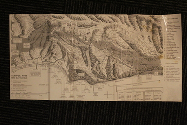
Maps, Major & Mrs Holt's Battle Map of Gallipoli, 2000
... Maps...Major & Mrs Holt's Battle Map of Gallipoli...Maps...Brochure containing battle field maps of Gallipoli campaign. Designed as a guide for visitors...Designed as a guide for visitors Major & Mrs Holt's Battle Map of Gallipoli Maps Slouch Hat Publications Tonie & Valmai Holt ...Brochure containing battle field maps of Gallipoli campaign. Designed as a guide for visitors97809585229662maps, gallipoli. holt