Showing 116 items matching "maps - kew (vic)"
-
 Kew Historical Society Inc
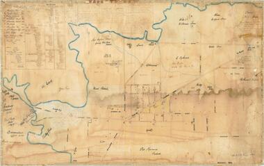
Map - Back to Kew 1875, Jesse Dannock, c.1931
... maps - kew (vic)...Kew Historical Society has an extensive collection of maps and plans; most relating to the former City of Kew (1860-1994). Within this collection, this hand-drawn map is unique. The most important and earliest original map of Kew in the collection, showing places of interest in early Kew. maps - kew (vic) mrs dannock's map cartography Hand-coloured map on heavy paper, depicting from Kew in 1875 from memory by Jesse Dannock. ...The Kew Historical Society has an extensive collection of maps and plans; most relating to the former City of Kew (1860-1994). Within this collection, this hand-drawn map is unique.The most important and earliest original map of Kew in the collection, showing places of interest in early Kew.Hand-coloured map on heavy paper, depicting from Kew in 1875 from memory by Jesse Dannock. The map includes the names of local institutions and old residents. These, and many of the street names are very faded and have been overwritten with biro at a later date.maps - kew (vic), mrs dannock's map, cartography -
 Kew Historical Society Inc
Map - Map of Kew and Hawthorn Districts
... maps - kew (vic)...Kew Historical Society Inc Kew Court House 188 High Street Kew melbourne Map of Kew, East Kew and Hawthorn produced for a Kew Real Estate Agent, RW Perry. The map is undated. maps - kew (vic) maps - hawthorn (vic) R.W. ...Map of Kew, East Kew and Hawthorn produced for a Kew Real Estate Agent, RW Perry. The map is undated.Two-colour map of Kew and Hawthorn Districts produced for by R.L. Jarrett for RW Perry, Real Estate & Insurance Agent. The map has unusual features such as a planned railway link from Kew Station to the former Outer Circle Railway. RW Perry / Real Estate & Insurance Agent, 602 High Street, East Kewmaps - kew (vic), maps - hawthorn (vic), r.w. perry, real estate agents -- kew (vic.) -
 Kew Historical Society Inc
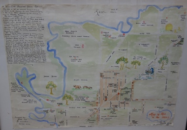
Map, Elizabeth Mackie, Kew 1875-1880s, c. 1985
... ...maps -- kew (vic.)...Kew. One of the most important maps of Kew in the KHS Collection is 'Back to Kew' created by Jesse Dannock. This water damaged map was in many places unreadable, and this re-creation by Elizabeth Mackie only included part of the original text. It was also liberally added to with pictorial symbols. elizabeth mackie plan of kew maps -- kew (vic ...Elizabeth Mackie was a member of the Kew Historical Society and a resident of 1 Molesworth Street. She researched and wrote the booklet 'Artists of Kew' and initiated research into authors with a connection to Kew. One of the most important maps of Kew in the KHS Collection is 'Back to Kew' created by Jesse Dannock. This water damaged map was in many places unreadable, and this re-creation by Elizabeth Mackie only included part of the original text. It was also liberally added to with pictorial symbols.A reinterpretation of the Back to Kew 1875 map created by Jesse Dannock in circa 1931. This hand-drawn map was created by Elizabeth Mackie in the 1980s.elizabeth mackie, plan of kew, maps -- kew (vic.), jesse dannock -
 Kew Historical Society Inc
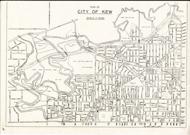
Plan, City of Kew, 1979
... plans - city of kew (vic.)...maps...Kew Historical Society Inc Kew Court House 188 High Street Kew melbourne Plan of the City of Kew produced for public distribution plans - city of kew (vic.) maps - kew (vic.) local government area - kew - victoria cartography Revised June 1979 Plan of City of Kew - Scale 1 : 15000 City of Kew Plan Plan City of Kew ...Plan of the City of Kew produced for public distributionPlan of City of Kew - Scale 1 : 15000Revised June 1979plans - city of kew (vic.), maps - kew (vic.), local government area - kew - victoria, cartography -
 Glen Eira Historical Society
Article - Outer Circle Linear Park
... Glen Eira Historical Society 965 Glen Huntly Rd Caulfield VIC 3162 melbourne OUTER CIRCLE LINEAR PARK, joint submission by cities of Kew, Camberwell, Malvern and Caulfield. A bound fifteen page submission, dated 08/07/1985, by four councils urging the creation of the Outer Circle Linear Park. Includes map ...OUTER CIRCLE LINEAR PARK, joint submission by cities of Kew, Camberwell, Malvern and Caulfield. A bound fifteen page submission, dated 08/07/1985, by four councils urging the creation of the Outer Circle Linear Park. Includes map and photographs. OUTER CIRCLE RAILWAY: A PLAN FOR A LINEAR PARK, report of the Outer Circle Study Group. Bound booklet of one hundred and thirty five typewritten and photocopied pages about the creation of this park. The Introduction was signed by Tom Roper, Minister for Planning and Environment, and by Joan Kirner, Minister for Conservation, Forests and Lands. Undated but the Introduction states that public submissions must be received by 31/05/1988. Includes maps, sketches of proposed facilities, a history of the former Outer Circle Railway Line, and a description of notable plants and trees. A double sided, one page leaflet, published by the Murrumbeena Outer Circle Parkland Retention Group, MOCPRG, with timeline of the park and map. Undated but the last date on the timeline is 1985. Includes small sheet headed WHAT CAN YOU DO? Cutting from the CAULFIELD CONTACT titled A NEW PARK IT’S OFFICIAL, dated 26/02/1988, on official announcement of the new park. Two copies of OUTER CIRCLE LINEAR PARK, a four paged pamphlet published by Outer Circle Linear Park Implementation Committee on the new park. Includes detailed map. Letter between Felicitie E. Campbell of the Caulfield Historical Society, dated 14/09/1988 supporting the naming of a section of the Linear Park as Boyd Park. Two pages typed and a hand written copy. Also a type written letter from Jim Badger, Manager, Cultural Services, City of Caulfield, supporting the naming as Boyd Park, dated 16/08/1988. An album of thirty five colour photographs by Peter Foeden and Associates, of the official opening of the Outer Circle Linear Park by Premier John Cain, 1988. Photographs are numbered and the album includes handwritten descriptions of each photograph. Two mounted photographs of the Caulfield section of Linear Park, undated. One black and white and one colour.outer circle linear park, outer circle railway, parks, saunders r. e., briggs a. g., quinn m., rudski b., outer circle study group, roper tom, kirner joan, dunstan david, railways, trees, murrumbeena, campbell felicitie e., badger jim, peter foeden and associates, campbell adack, lang robert, gallney cr., cain john, cain nancy, boyd john, boyd arthur, boyd merric, boyd penleigh, boyd robyn, boyd james, boyd guy, ballantyne mr. -
 Ringwood and District Historical Society
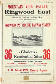
Flyer, Land Sale Brochure, Mountain View Estate, Ringwood East, Vic. - 1923
... Kew, Telephone Haw. 3428. Bi-fold advertisement for sale of residential allotments, including photographs, map, and summary of subdivision features and local facilities. Undated handwritten notation reads "streets don't exist today". Land Sale Brochure, Mountain View Estate, Ringwood East, Vic ...Bi-fold advertisement for sale of residential allotments, including photographs, map, and summary of subdivision features and local facilities. Undated handwritten notation reads "streets don't exist today".Subdivision layout includes Mullum Mullum Road, Rangeview Avenue, Press Avenue, and Mountview Avenue. Local Agent - J.B. McAlpin, Opposite Railway Station, Ringwood, Phone Ringwood 7. Vendor - T.J. Press, Builder, "Monterey", Second Avenue, Kew, Telephone Haw. 3428. -
 Narre Warren and District Family History Group
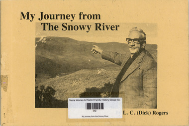
Book, LC 'Dick' Rogers, My journey from the Snowy River, 1982
... Vic.) Snowy River (NSW) The reminiscences of LC Rogers outlining his life as a drover in Victoria and Queensland. The author also describes the management of droving teams. Contents: Early days, Black Mountain Station, The bullock team, Dingoes, Shoeing horses, Bush days, Queensland experiences, Wulgulmerang, Later days at Wulgulmerang, Norwood - Swan Reach, Norwood - Kew, Travelling, The glorious future. Includes illustrations, maps ...The reminiscences of LC Rogers outlining his life as a drover in Victoria and Queensland. The author also describes the management of droving teams. Contents: Early days, Black Mountain Station, The bullock team, Dingoes, Shoeing horses, Bush days, Queensland experiences, Wulgulmerang, Later days at Wulgulmerang, Norwood - Swan Reach, Norwood - Kew, Travelling, The glorious future. Includes illustrations, maps and photographs.non-fictionThe reminiscences of LC Rogers outlining his life as a drover in Victoria and Queensland. The author also describes the management of droving teams. Contents: Early days, Black Mountain Station, The bullock team, Dingoes, Shoeing horses, Bush days, Queensland experiences, Wulgulmerang, Later days at Wulgulmerang, Norwood - Swan Reach, Norwood - Kew, Travelling, The glorious future. Includes illustrations, maps and photographs. droving, snowy river (vic.), snowy river (nsw) -
 Kew Historical Society Inc
Archive (series) - Subject File, Victoria Park : Concept Management Plan, Research Papers, 2004, 2004
... kew (vic) heritage studies - kew (vic.) Red cardboard wallet containing historical research by Graeme Butler, heritage architect, into the history of Victoria Park, Kew. The file also includes a draft Victoria Park Concept Master Plan, 2004. The research includes memoranda, maps ...Graeme Butler & AssociatesProject FilesProvenance OrderRed cardboard wallet containing historical research by Graeme Butler, heritage architect, into the history of Victoria Park, Kew. The file also includes a draft Victoria Park Concept Master Plan, 2004. The research includes memoranda, maps, photocopies of plans, forms, notes, aerial photos, and sundry references.graeme butler - heritage architect, victoria park - kew (vic), heritage studies - kew (vic.)graeme butler - heritage architect, victoria park - kew (vic), heritage studies - kew (vic.) -
 Kew Historical Society Inc
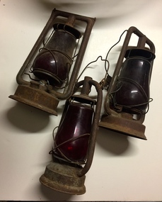
Equipment, City of Kew, Traffic Warning Lantern, 1945-1965
... Kew to the Society for safekeeping, rather than identifying them for destruction. The most significant items donated included old maps, including those issued by the Board of Works. Other items included photographs of public works undertaken by the Department. These traffic warning lanterns, while less historically significant, are indicative of a period of rapid urban development in the district during the post war period. traffic lanterns -- city of kew emergency lighting public works -- kew (vic.) ...One of three traffic warning lanterns donated by the City of Kew in 1984. The lanterns were used by the City Engineers Department for emergency street lighting to indicate dangerous conditions. The red glass in the lanterns symbolically represented danger.The Kew Historical Society is fortunate that the City Engineer, Mr Poulter, donated a number of items held by the City of Kew to the Society for safekeeping, rather than identifying them for destruction. The most significant items donated included old maps, including those issued by the Board of Works. Other items included photographs of public works undertaken by the Department. These traffic warning lanterns, while less historically significant, are indicative of a period of rapid urban development in the district during the post war period.City of Kew warning lantern (left) previously located in various streets and plant nurserytraffic lanterns -- city of kew, emergency lighting, public works -- kew (vic.) -
 Kew Historical Society Inc
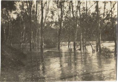
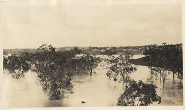
Photograph, Marnie McLeod, Floods of the River Yarra at Kew, 1916
... Kew are believed to be the earliest in the collection. Together with our original MMBW River Yarra map showing flood levels, these items, when compared allow researchers to gain a visual perspective of the extent of the flood in 1916. river yarra kew floods 1916 Inscription on reverse in pencil: "Flood River Yarra Kew Vic" Black and white photograph of flooded trees in Kew with rising dry ground in distance. ...The donation was accompanied by the following letter from the donor: "Hi. I found these in with family photos. Taken by family as Mamie McLeod was living in Fellows Street, Kew, so would be near there. Retain (or discard) as you see fit." [Donor's name and address withheld from public view]. To gain an insight into the flood levels at Kew, it is worth reading newspaper accounts of the event. The Age published an article - Valuable Gardens Destroyed at Kew - on 25 September 1916: "VALUABLE GARDENS DESTROYED AT KEW. From the heights of Studley Park, Kew, a splendid view of the flood waters can be obtained, and yesterday afternoon, despite continuous rain, crowds of citizens assembled there to witness the spectacle. There is a vast stretch of water some 300 or 400 yards broad, above the foot bridge connecting Gipps-street, Collingwood, and Studley Park. The river is only about 3 feet from the top of the embankment connecting with the ramp of the bridge on the Studiey Park side. When the upper llood waters come down it is almost a certainty that tne embankment will be submerged and the bridge rendered impassible. Below the bridge the waters again stretch out, and have submerged all the low-lying land on the Collingwood side and invaded the back premises ot the Kodak Co., Phoenix Biscuit Factory, a tannery adjoining thereto, the Shamrock Brewery, and Chinese gardens in the vicinity. At Walmer-street-bridge, at the end of Studley Park, the low-lying land on the Kew side is covered with water to the depth of many feet. Tlie land in question is owned in a great part by Mr Frank Lavers who haa gone in for intense culture on a pretty liberal scale on both the slopes of the hill and on the river flat. On the latter he is cultivating many acres of asparagus, and has at a considerable cost spent three years in preparing the ground and installing an irrigation system, reticulated from the Yan Yean water supply. This year the asparagus was put down, and the plants were in a promising condition. Tlie flood waters are now flowing fast over the land. The crop is ruined, and three years' work and expenditure destroyed. Mr. Laver's private residence fortunately is high above flood level, but two houses he owns off Young-street have been flooded out. Having been warned in time, the tenants removed their furniture hefore the water came down to Mr. Laver's residence, where they themselves have been given accommodation in the meantime. All the river flats in East Kew are under water. One or two low-lying houses have been flooded. Chipperfield's boat shed at Willsmere is nearly covered, and some Chinese gardens in the vicinity are several feet under water."This, and the other three photographs donated of floods in Kew are believed to be the earliest in the collection. Together with our original MMBW River Yarra map showing flood levels, these items, when compared allow researchers to gain a visual perspective of the extent of the flood in 1916. Black and white photograph of flooded trees in Kew with rising dry ground in distance.Inscription on reverse in pencil: "Flood River Yarra Kew Vic"river yarra, kew, floods 1916 -
 Kew Historical Society Inc
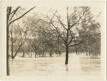
Photograph, Marnie McLeod, Floods on the River Yarra at Kew, 1916
... Kew are believed to be the earliest in the collection. Together with our original MMBW River Yarra map showing flood levels, these items, when compared allow researchers to gain a visual perspective of the extent of the flood in 1916. river yarra kew floods 1916 zig-zag bridge Inscription on reverse in ink "(pre 1920) Flood from Zig-zag bridge Yarra River, Kew Vic." ...The donation was accompanied by the following letter from the donor: "Hi. I found these in with family photos. Taken by family as Mamie McLeod was living in Fellows Street, Kew, so would be near there. Retain (or discard) as you see fit." [Donor's name and address withheld from public view]. To gain an insight into the flood levels at Kew, it is worth reading newspaper accounts of the event. The Age published an article - Valuable Gardens Destroyed at Kew - on 25 September 1916: "VALUABLE GARDENS DESTROYED AT KEW. From the heights of Studley Park, Kew, a splendid view of the flood waters can be obtained, and yesterday afternoon, despite continuous rain, crowds of citizens assembled there to witness the spectacle. There is a vast stretch of water some 300 or 400 yards broad, above the foot bridge connecting Gipps-street, Collingwood, and Studley Park. The river is only about 3 feet from the top of the embankment connecting with the ramp of the bridge on the Studiey Park side. When the upper llood waters come down it is almost a certainty that tne embankment will be submerged and the bridge rendered impassible. Below the bridge the waters again stretch out, and have submerged all the low-lying land on the Collingwood side and invaded the back premises ot the Kodak Co., Phoenix Biscuit Factory, a tannery adjoining thereto, the Shamrock Brewery, and Chinese gardens in the vicinity. At Walmer-street-bridge, at the end of Studley Park, the low-lying land on the Kew side is covered with water to the depth of many feet. Tlie land in question is owned in a great part by Mr Frank Lavers who haa gone in for intense culture on a pretty liberal scale on both the slopes of the hill and on the river flat. On the latter he is cultivating many acres of asparagus, and has at a considerable cost spent three years in preparing the ground and installing an irrigation system, reticulated from the Yan Yean water supply. This year the asparagus was put down, and the plants were in a promising condition. Tlie flood waters are now flowing fast over the land. The crop is ruined, and three years' work and expenditure destroyed. Mr. Laver's private residence fortunately is high above flood level, but two houses he owns off Young-street have been flooded out. Having been warned in time, the tenants removed their furniture hefore the water came down to Mr. Laver's residence, where they themselves have been given accommodation in the meantime. All the river flats in East Kew are under water. One or two low-lying houses have been flooded. Chipperfield's boat shed at Willsmere is nearly covered, and some Chinese gardens in the vicinity are several feet under water."This, and the other three photographs donated of floods in Kew are believed to be the earliest in the collection. Together with our original MMBW River Yarra map showing flood levels, these items, when compared allow researchers to gain a visual perspective of the extent of the flood in 1916. Panoramic view, believed to be looking north towards Fairfield from the Zig-Zag Bridge on the River Yarra. The inscription on the reverese identifies it as taken before 1920.Inscription on reverse in ink "(pre 1920) Flood from Zig-zag bridge Yarra River, Kew Vic."river yarra, kew, floods 1916, zig-zag bridge -
 Kew Historical Society Inc
Photograph, Marnie McLeod, Flood, River Yarra, Kew, 1916
... Kew are believed to be the earliest in the collection. Together with our original MMBW River Yarra map showing flood levels, these items, when compared allow researchers to gain a visual perspective of the extent of the flood in 1916. river yarra kew floods 1916 Inscription on reverse in ink "Flood R. Yarra Kew Vic ...The donation was accompanied by the following letter from the donor: "Hi. I found these in with family photos. Taken by family as Mamie McLeod was living in Fellows Street, Kew, so would be near there. Retain (or discard) as you see fit." [Donor's name and address withheld from public view]. To gain an insight into the flood levels at Kew, it is worth reading newspaper accounts of the event. The Age published an article - Valuable Gardens Destroyed at Kew - on 25 September 1916: "VALUABLE GARDENS DESTROYED AT KEW. From the heights of Studley Park, Kew, a splendid view of the flood waters can be obtained, and yesterday afternoon, despite continuous rain, crowds of citizens assembled there to witness the spectacle. There is a vast stretch of water some 300 or 400 yards broad, above the foot bridge connecting Gipps-street, Collingwood, and Studley Park. The river is only about 3 feet from the top of the embankment connecting with the ramp of the bridge on the Studiey Park side. When the upper llood waters come down it is almost a certainty that tne embankment will be submerged and the bridge rendered impassible. Below the bridge the waters again stretch out, and have submerged all the low-lying land on the Collingwood side and invaded the back premises ot the Kodak Co., Phoenix Biscuit Factory, a tannery adjoining thereto, the Shamrock Brewery, and Chinese gardens in the vicinity. At Walmer-street-bridge, at the end of Studley Park, the low-lying land on the Kew side is covered with water to the depth of many feet. Tlie land in question is owned in a great part by Mr Frank Lavers who haa gone in for intense culture on a pretty liberal scale on both the slopes of the hill and on the river flat. On the latter he is cultivating many acres of asparagus, and has at a considerable cost spent three years in preparing the ground and installing an irrigation system, reticulated from the Yan Yean water supply. This year the asparagus was put down, and the plants were in a promising condition. Tlie flood waters are now flowing fast over the land. The crop is ruined, and three years' work and expenditure destroyed. Mr. Laver's private residence fortunately is high above flood level, but two houses he owns off Young-street have been flooded out. Having been warned in time, the tenants removed their furniture hefore the water came down to Mr. Laver's residence, where they themselves have been given accommodation in the meantime. All the river flats in East Kew are under water. One or two low-lying houses have been flooded. Chipperfield's boat shed at Willsmere is nearly covered, and some Chinese gardens in the vicinity are several feet under water."This, and the other three photographs donated of floods in Kew are believed to be the earliest in the collection. Together with our original MMBW River Yarra map showing flood levels, these items, when compared allow researchers to gain a visual perspective of the extent of the flood in 1916. Small black and white photograph of flooded trees in Kew.Inscription on reverse in ink "Flood R. Yarra Kew Vicriver yarra, kew, floods 1916 -
 Kew Historical Society Inc
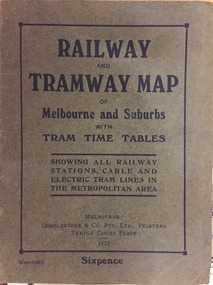
Map, Osboldstone & Co Pty Ltd, Railway and Tramway Map of Melbourne and Suburbs With Tram Timetables, 1917
... Kew Spur Line is also marked on the map. The Railway and Tramway Map of Melbourne and Suburbs With Tram Timetables is historically significant as it captures at a point in time, 1917, the development of public transport infrastructure in Melbourne. As such it illustrrates the theme: Connecting Victorians by transport and communications. railway maps -- melbourne (vic ...The Railway and Tramway Map of Melbourne and Suburbs With Tram Timetables lists existing Cable Tram Services before the entire network was electrified. By 1917 the tramways system was divided into regions including: the Melbourne Cable Tram Service; Prahran - Malvern Electric Trams; Hawthorn Electric Trams; Melbourne, Brunswick and Coburg Electric Trams; and Brighton Beach Electric Trams. The old Outer Circle railway line is marked as ending in Deepdene, with the remainder of the line to Fairfield marked as 'Unused'. The Kew tram along High Street in 1917 ended at the Harp Junction. The Kew Spur Line is also marked on the map.The Railway and Tramway Map of Melbourne and Suburbs With Tram Timetables is historically significant as it captures at a point in time, 1917, the development of public transport infrastructure in Melbourne. As such it illustrrates the theme: Connecting Victorians by transport and communications.Printed card-covered pocket sized map that folds out with three horizontal and vertical folds. Colour map, with scale, of the rail and tram networks on one side and sixteen sections of black and white printed text and timetable information on the reverse.railway maps -- melbourne (vic.), tramways maps -- melbourne (vic.), public transport -- melbourne (vic.) -- 1910-1920, cartography -
 Kew Historical Society Inc
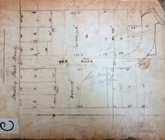
Plan - Subdivision Plan, Windella-Darnley Subdivision, Studley Park, 1920s
... Kew (Vic.) Merrion Place -- Kew (Vic.) Merrion Grove -- Kew (Vic.) Highbury Grove -- Kew (Vic.) "Antrim Avenue. See over for new plan" Version 1 of two subdivision plans (the later one is MAP.0027) for the section of Studley Park Road near the Junction on the south side. ...Subdivision plans are historically important documents used as evidence of the growth of suburbs in Australia. They frequently provide information about when the land was sold on which a built structure was subsequently constructed as well as evidence relating to surveyors and real estate and financial agents. The numerous subdivision plans in the Kew Historical Society's collection represent working documents, ranging from the initial sketches made in planning a subdivision to printed plans on which auctioneers or agents listed the prices for which individual lots were sold. In a number of cases, the reverse of a subdivision plan in the collection includes a photograph of a house that was also for sale by the agent. These photographs provide significant heritage information relating house design and decoration, fencing and household gardens.Version 1 of two subdivision plans (the later one is MAP.0027) for the section of Studley Park Road near the Junction on the south side. Named in the subdivision are the mansions of Darley and Windella (now demolished). Before the subdivision of Darley and Windella, both houses fronted Studley Park Road. Both houses appear to be advertised as lots in the subdivision. Bisecting the subdivision is a street, Antrim Avenue that was never constructed. A street, which was subsequently constructed in this vicinity, was Merrion Place, which now runs between Studley Park Road and Highfield Grove. There are 14 proposed lots in this subdivision."Antrim Avenue. See over for new plan"subdivision plans - kew, studley park, windella, darnley, studley park road -- kew (vic.), merrion place -- kew (vic.), merrion grove -- kew (vic.), highbury grove -- kew (vic.) -
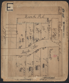 Kew Historical Society Inc
Plan - Subdivision Plan, Lodged Plan No.6518, 1920-1940
... Kew. The Plans in the collection are rarely in pristine form, being working plans on which the agent would write notes and record lots sold and the prices of these. The subdivision plans are historically significant examples of the growth of urban Melbourne from the beginning of the 20th Century up until the 1980s. A number of the plans are double-sided and often include a photograph on the reverse. subdivision plans - balwyn Deepdene Whitehorse Road -- Deepdene (Vic.) Deepdene Road -- Deepdene (Vic.) Burke Road -- Deepdene (Vic.) Reconciling this hand-drawn subdivision plan with a modern map ...The Kew Historical Society collection includes almost 100 subdivision plans pertaining to suburbs of the City of Melbourne. Most of these are of Kew, Kew East or Studley Park, although a smaller number are plans of Camberwell, Deepdene, Balwyn and Hawthorn. It is believed that the majority of the plans were gifted to the Society by persons connected with the real estate firm - J. R. Mathers and McMillan, 136 Cotham Road, Kew. The Plans in the collection are rarely in pristine form, being working plans on which the agent would write notes and record lots sold and the prices of these. The subdivision plans are historically significant examples of the growth of urban Melbourne from the beginning of the 20th Century up until the 1980s. A number of the plans are double-sided and often include a photograph on the reverse. Reconciling this hand-drawn subdivision plan with a modern map of the area is initially a challenge due to a change of street names. Argyle Road in the centre of the subdivision was to be renamed Deepdene Road, and the street named Deepdene Road on the plan was to become Deepdene Place. Of interest is the nursery on the corner of Argyle and Whitehorse Roads. During this period there were a number of nurseries servicing the Kew and Balwyn areas. The subdivision was essentially of the land formerly occupied by the house 'Deepdene'.subdivision plans - balwyn, deepdene, whitehorse road -- deepdene (vic.), deepdene road -- deepdene (vic.), burke road -- deepdene (vic.) -
Kew Historical Society Inc
Archive (Sub-series) - Subject File, JUDD Family, 1958
... Typically files will contain primary and secondary sources. c w rick fairhall parkhill - hillcrest avenue - kew (vic) thomas judd pioneers - kew (vic) Archive file containing information important information by and about the Judd family, pioneers of Kew, and owners of Park Hill (now in Hillcrest Avenue) from 1853. The file contains a number of original files provenanced to the Judd family including a subdivision brochure of the Park Hill Estate (1916) that includes a map of the subdivision, an early photo of the ten-roomed house. ...Various partiesReference, Research, InformationKHS OrderSubject file containing information important information by and about the Judd family, pioneers of Kew, and owners of Park Hill (now in Hillcrest Avenue) from 1853. The file contains a number of original files provenanced to the Judd family including a subdivision brochure of the Park Hill Estate (1916) that includes a map of the subdivision, an early photo of the ten-roomed house. Other primary sources include a seven page photocopy (& transcript) of notes on early Kew by Thomas Judd Jnr (1950). An undated letter accompanying the information refers to Miss Ina Balaam, the last descendant of the family to live in the house. The file also includes a photocopy of the obituary of Thomas Judd and a newspaper article/clipping from 1972, which includes a short history of the house and a photograph. Other items relating to Thomas Judd and James Bonwick are stored in archive boxes in the collection store.c w rick fairhall, parkhill - hillcrest avenue - kew (vic), thomas judd, pioneers - kew (vic)c w rick fairhall, parkhill - hillcrest avenue - kew (vic), thomas judd, pioneers - kew (vic) -
 Kew Historical Society Inc
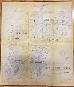
Plan, City Engineers Department (Heidelberg), City of Heidelberg Plan: Scale 20 chns to 1 inch, 1970-1993
... Kew melbourne Gwen Barton McWilliam (nee: Nelson), OAM, BA (1933- ). Gwen McWilliam is well known as an authority on the history of Boroondara and the author of a large number of books and pamphlets about the City. She was awarded the medal of the Order of Australia in 2001 ‘for service to the community of Hawthorn and district, particularly through the research, documentation and publication of its history.’ Primary source annotated by a distinguished local historian. city of heidelberg maps -- heidelberg (vic ...Gwen Barton McWilliam (nee: Nelson), OAM, BA (1933- ). Gwen McWilliam is well known as an authority on the history of Boroondara and the author of a large number of books and pamphlets about the City. She was awarded the medal of the Order of Australia in 2001 ‘for service to the community of Hawthorn and district, particularly through the research, documentation and publication of its history.’ Primary source annotated by a distinguished local historian.Plan of number of areas in the City of Heidelberg showing municipal and ward boundaries, subsequently annotated by the historian Gwen McWilliam, identifying significant landholdings, subdivisions and key dates.The base map was printed in 1970 and annotated c.1993. The plan was donated to the Kew Historical Society by Gwen McWilliam. Handwritten annotations by Gwen McWilliam, 1993city of heidelberg, maps -- heidelberg (vic.), gwen mcwilliam -
 Kew Historical Society Inc
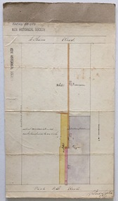
Plan, Survey Plan, Park Hill Road, Kew, 1880-1890
... Handdrawn survey plan by a former surveyor and town clerk of Kew surveys - kew, maps - kew, holland loxton, park hill road - kew Holland Loxton -- Surveyor Survey plans -- Parkhill Road -- Kew (Vic.) ...The streets identified on the survey plan - Cotham Road, Park Hill Road East, Park Hill Road West in Kew were each gazetted by the Victorian Government in 1865. The hand-coloured survey plan was completed by Holland Loxton, Town Clerk and Surveyor of the Borough of Kew from 1866. The unnamed survey plan includes names of land owners in addition to measurements (2 chains to 1 inch) and streets. Named owners include Webster, Payne and Francom which will enable us to narrow down the creation date of the survey.Handdrawn survey plan by a former surveyor and town clerk of KewHand drawn and coloured survey plan created by Holland Loxton, Surveyor and Town Clerk of Kew, showing land owned by Payne in Park Hill Road, Kew. The plan includes street names, land measurements and land owners.surveys - kew, maps - kew, holland loxton, park hill road - kew, holland loxton -- surveyor, survey plans -- parkhill road -- kew (vic.) -
 Kew Historical Society Inc
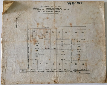
Plan - Subdivision Plan, J Hurrey, Section 115 in the Parish of Boroondara Near Richmond Bridge, 1853
... Kew. This subdivision plan is the earliest original map or plan in the collection which shows parts of what is now the City of Boroondara, dating from circa 1853. It provides important information for researchers on subsequent subdivisions following the original land sales in [Camberwell] Boroondara. The site, on the east side of Burke Road is a highly-significant and historic site. This is believed to be the only extant copy of the subdivision in public collections. parish of boroondara, subdivision plans - camberwell, section 115 - boroondara subdivision plans -- camberwell (vic ...Despite the plans claims that it is a subdivision near the Richmond Bridge, Section 115 was located at what is now Camberwell Junction. While the plan only lists government roads rather than named streets, the section was located on the east side of Burke Road, stretching up the hill from the current Junction. Research on Trove, conducted by Kerry Fairbank, discovered an advertisement for unsold lots in Section 115 which clarifies the extent and location of subsequent land sales in the original section. The original article can be viewed through the link in the catalogue record. The interesting link to Kew is the reference to James Beavan as the purchaser of lots 14 and 15. The historian Gwen McWilliam has notes that a Mr Beavan changed his name from Bevan. The Bevans were descendants of the Derricks family of Kew. This subdivision plan is the earliest original map or plan in the collection which shows parts of what is now the City of Boroondara, dating from circa 1853. It provides important information for researchers on subsequent subdivisions following the original land sales in [Camberwell] Boroondara. The site, on the east side of Burke Road is a highly-significant and historic site. This is believed to be the only extant copy of the subdivision in public collections.A small plan on parchment listing 28 lots, between one and two acres each, for sale in Section 115 in the Parish of Boroondara, dating from 1853 when the portion was subdivided.Obverse: Lot 16 "Joseph Duval", Lots 14 & 15 "James Beavan". Other annotations (measurements) are unreadable. Reverse: "KH-981 / Section 115 in the Parish of Boroondara / Near Richmond Bridge / 1640T. / J Duval / 14-15 J. Beavanparish of boroondara, subdivision plans - camberwell, section 115 - boroondara, subdivision plans -- camberwell (vic), riverscape road, burke road, camberwell junction -
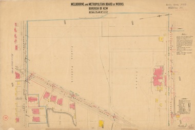 Kew Historical Society Inc
Plan, Melbourne & Metropolitan Board of Works : Borough of Kew : Detail Plan No.1297, 1904
... maps in this collection are invaluable and unique tools for researchers and heritage consultants. A number of the plans are not held in the collection of the State Library of Victoria so they have the additional attribute of rarity. melbourne and metropolitan board of works, detail plans mmbw 1297 cartography Kew (Vic.) — municipal collection Original survey plan, issued by the MMBW to a sewage contractor with responsibility for constructing sewers in the area identified on the plan within the Borough of Kew. ...The Melbourne and Metropolitan Board of Works (MMBW) plans were produced from the 1890s to the 1950s. They were crucial to the design and development of Melbourne's sewerage and drainage system. The plans, at a scale of 40 feet to 1 inch (1:480), provide a detailed historical record of Melbourne streetscapes and environmental features. Each plan covers one or two street blocks (roughly six streets), showing details of buildings, including garden layouts and ownership boundaries, and features such as laneways, drains, bridges, parks, municipal boundaries and other prominent landmarks as they existed at the time each plan was produced. (Source: State Library of Victoria)This plan forms part of a large group of MMBW plans and maps that was donated to the Society by the Mr Poulter, City Engineer of the City of Kew in 1989. Within this collection, thirty-five hand-coloured plans, backed with linen, are of statewide significance as they include annotations that provide details of construction materials used in buildings in the first decade of the 20th century as well as additional information about land ownership and usage. The copies in the Public Record Office Victoria and the State Library of Victoria are monochrome versions which do not denote building materials so that the maps in this collection are invaluable and unique tools for researchers and heritage consultants. A number of the plans are not held in the collection of the State Library of Victoria so they have the additional attribute of rarity.Original survey plan, issued by the MMBW to a sewage contractor with responsibility for constructing sewers in the area identified on the plan within the Borough of Kew. The plan was at some stage hand-coloured, possibly by the contractor, but more likely by officers working in the Engineering Department of the Borough and later Town, then City of Kew. The hand-coloured sections of buildings on the plan were used to denote masonry or brick constructions (pink), weatherboard constructions (yellow), and public buildings (grey). This plan of Kew encompasses the area bounded by Barkers Road, High Street and Stevenson Street. Because of the angle created by High Street, a number of houses on the northern side of High Street are shown. The area is dominated by one of the great original landholdings in Kew, described here as the ‘Findon Paddock’. ‘Findon’, the house from which the name of the paddock was taken fronts Stevenson Street and was clearly a rambling structure. The best-known occupant of Findon was Henry ‘Money Miller’ who bought the house in 1871. Miller was a member of Victoria’s first parliament and assisted in the framing of its constitution. Findon was to be subdivided as early as 1912, when the Findon Subdivision was advertised to be sold by auction. In the plan of the subdivision, the original house is not shown, so, presumably it had previously been demolished. Fincham & Son moved the organ, built by Henry Willis, which was installed in the house, first to ‘Whernside’ in Toorak, and later to the Box Hill Methodist Church.melbourne and metropolitan board of works, detail plans, mmbw 1297, cartography, kew (vic.) — municipal collection -
Kew Historical Society Inc
Archive (Sub-series) - Subject File, Kew Historical Society, Gallipoli & Beyond 2015, 2014
... kew (vic) - josiah earl barnes first world war boroondara historical societies association (bhsa) gallipoli & beyond - special projects wwi Gallipoli & Beyond was a Commonwealth funded project involving members of the Boroondara Historical Societies Association. The project involved roadshow, exhibitions, talks, and the publication of a history. The file contains newspaper and magazine, articles/clippings, promotional materials, certificates, etc. The Kew Historical Society participated in a number of events and held an exhibition on the embarkation photographs of Josiah Earl Barnes. The captions and the posters are held separately in the map ...Boroondara Historical Societies AssociationReference, Research, InformationProvenance orderGallipoli & Beyond was a Commonwealth funded project involving members of the Boroondara Historical Societies Association. The project involved roadshow, exhibitions, talks, and the publication of a history. The file contains newspaper and magazine, articles/clippings, promotional materials, certificates, etc. The Kew Historical Society participated in a number of events and held an exhibition on the embarkation photographs of Josiah Earl Barnes. The captions and the posters are held separately in the map drawers.photographers - kew (vic) - josiah earl barnes, first world war, boroondara historical societies association (bhsa), gallipoli & beyond - special projects, wwiphotographers - kew (vic) - josiah earl barnes, first world war, boroondara historical societies association (bhsa), gallipoli & beyond - special projects, wwi -
Kew Historical Society Inc
Archive (Sub-series) - Subject File, Kew Historical Society, GRIMES, Charles, 1962
... Typically files will contain primary and secondary sources. charles grimes commemorations - kew (vic.) european exploration - kew (vic) yarra river - history Charles Grimes was acting Surveyor-General of the Colony of New South Wales. He was the first European cartographer to map ...Various partiesReference, Research, InformationSecondary Values (KHS Imposed Order)Charles Grimes was acting Surveyor-General of the Colony of New South Wales. He was the first European cartographer to map the lower reaches of the Yarra River. The reference file contains both research on the ‘exploration’ by Grimes as well as information on a re-enactment, sponsored by the Kew Historical Society in 1978, to mark the 175th year of his party’s arrival in the area of what is now Dight’s Falls. In the file is a 13-page handwritten document to be used as a script for a speech during the reenactment, which also includes details of the costumes to be worn. There are additional unpublished manuscripts in the file about Grimes and his ‘journey’ by Mr Chinner and Mavis Rolley. The file also includes newspaper articles/clippings as well as sundry published articles.charles grimes, commemorations - kew (vic.), european exploration - kew (vic), yarra river - historycharles grimes, commemorations - kew (vic.), european exploration - kew (vic), yarra river - history -
Kew Historical Society Inc
Archive (Series) - Subject File, Kew Historical Society, Hawthorn (Vic) - History, 1958
... Maps of Kew’ (archive file) and the newspaper collection (boxed newspapers). The files currently stored in this archive file include: Allen, J Alex, ‘The Red Lion Inn and Early Hawthorn’ (RHSV 1946), Serpell, TE, ‘Early History of Hawthorn’ (5pp), and Bonwick, J, ‘A Sketch of Boroondara’ (1858). Hawthorn (Vic ...Various partiesReference, Research, InformationSecondary Values (KHS Imposed Order)Subject file containing typescripts relating to the early history of Hawthorn. The files were donated to the Society from the Preshil School archives. Some of the files were subsequently moved to other files or archive boxes including ‘Maps of Kew’ (archive file) and the newspaper collection (boxed newspapers). The files currently stored in this archive file include: Allen, J Alex, ‘The Red Lion Inn and Early Hawthorn’ (RHSV 1946), Serpell, TE, ‘Early History of Hawthorn’ (5pp), and Bonwick, J, ‘A Sketch of Boroondara’ (1858).hawthorn - history - 19th century, red lion inn, james bonwickhawthorn - history - 19th century, red lion inn, james bonwick -
Kew Historical Society Inc
Archive (Sub-series) - Subject File, Kew Historical Society, Hays Paddock (Kew East), 1958
... Typically files will contain primary and secondary sources. kew historical society - archives hays paddock - kew east (vic) parks and gardens - kew east (vic) Archive file containing many newspaper/magazine articles/clippings (1979-2016), some published by the City of Boroondara, and maps, summaries of reports (KNews, 1980) and proposals to create an ‘integrated playground’ at Hays Paddock. ...Various partiesReference, Research, InformationSecondary Values (KHS Imposed Order)Subject file containing many newspaper/magazine articles/clippings (1979-2016), some published by the City of Boroondara, and maps, summaries of reports (KNews, 1980) and proposals to create an ‘integrated playground’ at Hays Paddock.kew historical society - archives, hays paddock - kew east (vic), parks and gardens - kew east (vic)kew historical society - archives, hays paddock - kew east (vic), parks and gardens - kew east (vic) -
Kew Historical Society Inc
Archive (Sub-series) - Subject File, Kew Historical Society, HODDLE Survey, 1997
... Typically files will contain primary and secondary sources. kew historical society - archives kew (vic) - history robert hoddle - surveyor hoddle tree - kew (vic) jack hackett Photocopied correspondence and maps (surveys) relating to surveys ordered by Robert Hoddle, Government Surveyor. ...Various partiesReference, Research, InformationSecondary Values (KHS Imposed Order)Photocopied correspondence and maps (surveys) relating to surveys ordered by Robert Hoddle, Government Surveyor. Authors of letters and information include Gwen McWilliam and Jack Hackett. Much of the correspondence relates to the site of the ‘Hoddle Tree’, currently located in the Kew Golf Course. Jack Hackett’s original map is contained in the map drawers in the Society’s archive.kew historical society - archives, kew (vic) - history, robert hoddle - surveyor, hoddle tree - kew (vic), jack hackettkew historical society - archives, kew (vic) - history, robert hoddle - surveyor, hoddle tree - kew (vic), jack hackett -
 Kew Historical Society Inc
Book, Private and Public Memory: a history of Malvern / by Lynne Strahan, 1989
... Kew Historical Society Inc Kew Court House 188 High Street Kew melbourne malvern (vic) - history [vi], 289 p., [40] p. of plates : ill., maps, ports. ...[vi], 289 p., [40] p. of plates : ill., maps, ports.malvern (vic) - history -
![Book, Frank Tate: a biography / [by] RJW Selleck, 1982](/media/collectors/550653872162f11fb04854aa/items/5d03488021ea7b095053d265/item-media/5d03b35921ea670b18defdc1/item-fit-380x285.jpg?cb=6) Kew Historical Society Inc
Kew Historical Society IncBook, Frank Tate: a biography / [by] RJW Selleck, 1982
... Kew Historical Society Inc Kew Court House 188 High Street Kew melbourne notable residents - kew (vic) education - history - victoria frank tate (1864-1939) xii, 362 p., [13] p. of plates : maps Frank Tate: a biography / [by] RJW Selleck Book Book Melbourne University Press ...xii, 362 p., [13] p. of plates : mapsnotable residents - kew (vic), education - history - victoria, frank tate (1864-1939) -
![Book, The Northcote Side of the River / [by] Andrew Lemon, 1983](/media/collectors/550653872162f11fb04854aa/items/5d034cac21ea7b09505990ad/item-media/5d034cca21ea7b095059b2fd/item-fit-380x285.jpg?cb=6) Kew Historical Society Inc
Kew Historical Society IncBook, The Northcote Side of the River / [by] Andrew Lemon, 1983
... Kew Historical Society Inc Kew Court House 188 High Street Kew melbourne northcote (vic) - history 306 p. : ill., facsims., maps, ports The Northcote Side of the River / [by] Andrew Lemon Book Book Hargreen Publishing ...306 p. : ill., facsims., maps, portsnorthcote (vic) - history -
 Kew Historical Society Inc
Book, Jane Nigro, Greetings From Malvern: a commemorative collection of postcards and photographs, 1994
... Kew Historical Society, founded in 1958, has an extensive reference library, of which this book is a part. Volumes in the library are used by members for research into aspects of local history and/or to support the Society's collections of pictures, maps, fashion and artefacts. Reference books have entered the collection through donation, presentation, collection and purchase. malvern (vic ...Malvern, Vic. : Malvern Historical Society Inc., 1994 [40] p. : chiefly ill. ; 22 x 30 cm. non-fictionmalvern (vic.) -- pictorial works, malvern (vic.) -- history. -
 Kew Historical Society Inc
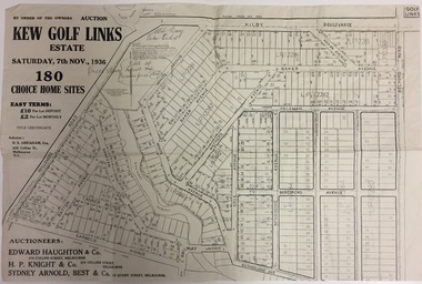
Plan - Subdivision Plan, Kew Golf Links Estate, 1936, 1936
... map are named after the proposed Kodak Factory to be built on the site. The subdivision of the Kew Golf Links Estate was a major subdivision of farmland in Kew. The site was at one stage designated for industrial development and the building of a new Kodak factory. The decision by Council to oppose the redevelopment makes the beginning of the period when all industrial development was banned in Kew. subdivision plans - kew (vic ...The Kew Golf Links Estate was a major subdivision in North Kew. It derived its title due to the land being previously occupied by the Kew Golf Club, which transferred its course to a number of locations before occupying its current site. The Plan advertises 180 choice home sites. The street names are somewhat different today as those on the map are named after the proposed Kodak Factory to be built on the site. The subdivision of the Kew Golf Links Estate was a major subdivision of farmland in Kew. The site was at one stage designated for industrial development and the building of a new Kodak factory. The decision by Council to oppose the redevelopment makes the beginning of the period when all industrial development was banned in Kew.Monochrome printed, folded subdivision plan for the Kew Golf Links Estate, to be auctioned on 7 November 1936. Streets named include: Carnegie Avenue, Willsmere Road, Kilby Boulevarde, Kodak Avenue, Coleman Avenue, Beresford Avenue, McConchie Avenue, Cole Avenue, White Avenue, Baker Avenue, Spruzen Avenue, Tanner Avenue, Ratten Avenue, Mathers Avenue, Railway Avenue, Sutherland Avenue, and Belford Road. The position of the Yarra River and a large Drainage Reserve are marked on the plan. Lots for sale are numbered. Existing buildings are designated with a square.subdivision plans - kew (vic), kodak factory - kew (vic)