Showing 106 items matching "maps bacchus marsh"
-
 Bacchus Marsh & District Historical Society
Map, Bacchus Marsh Township and Nearby Districts Maps Volume
... ...Maps Bacchus Marsh...This volume of maps is believed to have been compiled by staff at the Shire of Bacchus Marsh and was presumably used to inform and assist Shire staff and Councillors in the carriage of their duties....Most of the maps and plans are of Bacchus Marsh and nearby areas but some maps are of nearby towns such as Melton, Ballan and Blackwood. ...Maps Maps Bacchus Marsh Maps Bacchus Marsh Region One bound volume of maps comprising cadastral maps, (indicating property owners and land boundaries), land plans and real estate auction plans and advertising material, and other maps indicating major infrastructure like proposed roads and irrigation areas. ...This volume of maps is believed to have been compiled by staff at the Shire of Bacchus Marsh and was presumably used to inform and assist Shire staff and Councillors in the carriage of their duties.This collection of maps are significant due to their rarity as many of them are unique maps made for local purposes in the Bacchus Marsh region. They are also of strong research value containing a wide variety of information including landholders, land sales, infrastructure, such as roads, bridges, public, commercial and private buildings, houses, land use, and geographic features over multiple decades from the late nineteen century into the middle part of the twentieth century.One bound volume of maps comprising cadastral maps, (indicating property owners and land boundaries), land plans and real estate auction plans and advertising material, and other maps indicating major infrastructure like proposed roads and irrigation areas. Most of the maps and plans are of Bacchus Marsh and nearby areas but some maps are of nearby towns such as Melton, Ballan and Blackwood. The volume comprises 52 pages. Most pages have a single map or plan pasted onto it but some contain 2 or 3 different maps. There are 81 maps in total. Map 1 Liquidators Sale 1896. Map 2. Woodside Estate Sale 1913. maps, maps bacchus marsh, maps bacchus marsh region -
 Bacchus Marsh & District Historical Society
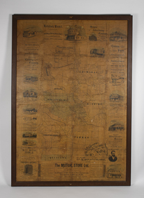
Map, The Unique Advertising Combine, The Unique Combine's New Map of the Shire of Bacchus Marsh, 1890
... Maps Bacchus Marsh Shire... Express newspaper on 29 March 1890 , page 2, indicated that subscribers to the Bacchus Marsh Express could obtain a copy of this map in the next issue of that newspaper. ...A map of the Shire of Bacchus Marsh produced in March 1890. ...Another similar example for the Shire of Mornington is held by the State Library of Victoria, Maps Bacchus Marsh Shire Shops Bacchus Marsh A map of the Shire of Bacchus Marsh produced in March 1890. ...This map was one of a number of similar maps produced for advertising purposes by a company called, 'The Unique Advertising Combine'. The company was located in Melbourne on Queens Walk. A brief item in the Bacchus Marsh Express newspaper on 29 March 1890 , page 2, indicated that subscribers to the Bacchus Marsh Express could obtain a copy of this map in the next issue of that newspaper. On the map is the detail that it was compiled by W.H. Bonney from official records supplied by D. A. Little, hire Secretary, (of Bacchus Marsh Shire).This map with its accompanying illustrations of local businesses and shops in Bacchus Marsh is an important documentary and visual snapshot of the town and district of Bacchus Marsh in the later part of the nineteenth century. The illustrations for some of the local businesses are the only known visual record of those particular buildings. The map is a rare surviving example of the material produced by The Unique Advertising Combine. Another similar example for the Shire of Mornington is held by the State Library of Victoria,A map of the Shire of Bacchus Marsh produced in March 1890. The map is mounted on a board and enclosed within a timber frame. The map includes an inset detail section showing the central part of the township of Bacchus Marsh including the main shopping and business streets. Land holdings with the first European land holders names indicated are included on the map. Rivers, creeks, major roads and the railway line are also shown on the map. Around the edges of the map are illustrated advertisements mostly for Bacchus Marsh businesses but which also includes some businesses located in Melbourne. maps bacchus marsh shire, shops bacchus marsh -
 Bacchus Marsh & District Historical Society
Map, Bacchus Marsh Region Parish Plans: Folded set of maps
... Maps Bacchus Marsh Region...Set of Victorian Lands Department Parish Plans covering the township of Bacchus Marsh and surrounding districts. Folded. BMDHS Location: AR/SU27/D2: Map Drawers...Bacchus Marsh & District Historical Society Lerderderg Library Main Street Bacchus Marsh Maps Bacchus Marsh Region Bacchus Marsh Victoria Maps Set of Victorian Lands Department Parish Plans covering the township of Bacchus Marsh and surrounding districts. ...Set of Victorian Lands Department Parish Plans covering the township of Bacchus Marsh and surrounding districts. Folded. BMDHS Location: AR/SU27/D2: Map Drawersmaps bacchus marsh region, bacchus marsh victoria maps -
 Bacchus Marsh & District Historical Society
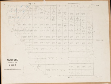
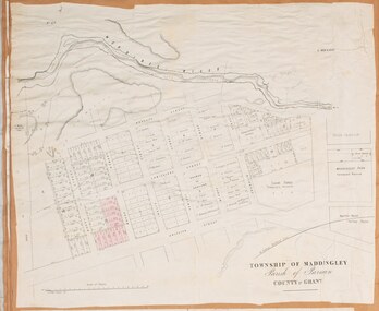
Map, Mouyong Parish Map, County of Grant
... Maps...Bacchus Marsh Region Parish Plans...Mouyong Parish Map, County of Grant Map Shire of Bacchus Marsh ...A single page paper map showing the map for the Parish of Mouyong in the County of Grant. Cadastral map showing land ownership. The map is pasted into a bound volume containing 76 maps or plans in total. High resolution digital image stored on BMDHS computer network. Photo lithographed at the Department of Lands and Survey Melbourne by T. F. McGauran, 9. 4. 07mouyong parish plan, mouyong parish maps, bacchus marsh region parish plans -
 Bacchus Marsh & District Historical Society
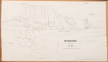
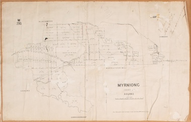
Map, Myrniong Parish Map 1904
... Maps...Bacchus Marsh Region Parish Plans...Myrniong Parish Map 1904 Map Shire of Bacchus Marsh ...A single page paper map showing the map for the Parish of Myrniong in the County of Bourke. A cadastral map showing parish boundaries and land ownership. The map is pasted into a bound volume containing 76 maps or plans in total. High resolution digital image stored on BMDHS computer network. myrniong parish plan, myrniong parish maps, bacchus marsh region parish plans -
 Bacchus Marsh & District Historical Society
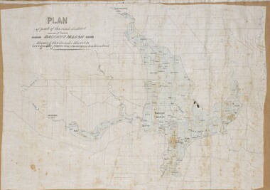
Map, Plan of part of the road district of Bacchus Marsh circa 1856-1862
... Maps...Bacchus Marsh Road District...Bacchus Marsh was constituted as the Bacchus Marsh Road District. This entity continued until 1862 when the name changed to the Bacchus Marsh and Maddingley Road District. This new entity lasted until 1871 when the local government authority in accordance with new statewide legislation became known as the Shire of Bacchus Marsh. The title of this plan being a plan of 'a portion of the road district of Bacchus Marsh' suggests that the plan was produced sometime between 1856 and 1862. The main purpose of this map...A single page paper map showing a plan of part of the road district of Bacchus Marsh. The map is pasted into a bound volume containing 76 maps or plans in total. ...maps or plans in total. High resolution digital image stored on BMDHS computer network. Plan of part of the road district of Bacchus Marsh circa 1856-1862 Map Shire of Bacchus Marsh ...Local government in much of Victoria including the Bacchus Marsh area began with the formation of 'local committees'. These local committees could make representations to a Central Road Board regarding plans for road construction. Road construction and maintenance were seen as the essential tasks of these early local government authorities. By 1856 the local committee in Bacchus Marsh was constituted as the Bacchus Marsh Road District. This entity continued until 1862 when the name changed to the Bacchus Marsh and Maddingley Road District. This new entity lasted until 1871 when the local government authority in accordance with new statewide legislation became known as the Shire of Bacchus Marsh. The title of this plan being a plan of 'a portion of the road district of Bacchus Marsh' suggests that the plan was produced sometime between 1856 and 1862. The main purpose of this map was to shown the irrigable land in the district and the sources from which water for irrigation could be drawn. Bacchus Marsh was an early irrigation district in Victoria. Irrigation trusts were formed in the 1880s and 1890s to manage irrigation districts. But this was the culmination of many years of earlier attempts to construct irrigation systems in the Bacchus Marsh area and create a system to manage irrigation more broadly. This map dating from around 1856-1862 is an important cartographic document which provides evidence of how the early planning for irrigation was developing in the Bacchus Marsh region.A single page paper map showing a plan of part of the road district of Bacchus Marsh. The map is pasted into a bound volume containing 76 maps or plans in total. High resolution digital image stored on BMDHS computer network. bacchus marsh victoria maps, bacchus marsh road district, local government, road districts, irrigation -
 Bacchus Marsh & District Historical Society
Map, Gorrockburkchap Parish Map, County of Grant c.1906
... Maps...Bacchus Marsh Region Parish Plans...Gorrockburkchap Parish Map, County of Grant c.1906 Map Shire of Bacchus Marsh ...The parish of Gorrockburkchap (sometimes spelled Gorrockburkghap) lies to the west and south west of the township of Bacchus Marsh. The locality of Rowsley is situated within this parish area.A single page paper map showing the parish plan for Gorrockburkchap in the County of Grant. A cadastral map showing parish boundaries and land ownership The map is pasted into a bound volume containing 76 maps or plans in total. High resolution digital image stored on BMDHS computer network. gorrockburkchap parish maps, rowsley victoria maps, bacchus marsh region parish plans -
 Bacchus Marsh & District Historical Society
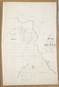
Map, 'Map of Darley' circa 1877-1897
... Maps...Bacchus Marsh Victoria Maps...This map shows the early laid out streets and roads for the village of Darley and the main roads and streets in the central area of the township of Bacchus Marsh. ...A single page paper map showing the village of Darley and the township of Bacchus Marsh. Scale 10 chains to 1 inch. ...Darley Victoria Maps Bacchus Marsh Victoria Maps A single page paper map showing the village of Darley and the township of Bacchus Marsh. ...This map shows the early laid out streets and roads for the village of Darley and the main roads and streets in the central area of the township of Bacchus Marsh. The date of the map is not known. Landmarks indicated on the map including the Anglican Church in Church Street (Gisborne Road), opposite the Presbyterian Church, and the Baptist Church at its pre-1898 Main Street location suggest the map is dated between 1877 and 1897. Landholders names can be seen on some of the allotments of land marked in this map, including the names Clifton, Cosgrove, O'Hagan, McFarlane, Nagle, O'Hagan, Simpson and Vallence.A single page paper map showing the village of Darley and the township of Bacchus Marsh. Scale 10 chains to 1 inch. The map is pasted into a bound volume containing 76 maps or plans in total. High resolution digital image stored on BMDHS computer network. darley victoria maps, bacchus marsh victoria maps -
 Bacchus Marsh & District Historical Society
Map, Myrniong Parish Map, County of Bourke, 1882
... Maps...Bacchus Marsh Region Parish Plans...Myrniong Parish Map, County of Bourke, 1882 Map Shire of Bacchus Marsh ...A single page paper map showing the map for the Parish of Myrniong in the County of Bourke. A cadastral map showing parish boundaries and land ownership. The map is pasted into a bound volume containing 76 maps or plans in total. High resolution digital image stored on BMDHS computer network. Photo-lithographed at the Department of Lands and Survey, Melbourne by J. Noone, 17.7.82myrniong parish plan, myrniong parish maps, bacchus marsh region parish plans -
![Map, Plan of Town Allotments Bacchus Marsh [1891-1897]](/media/collectors/5e461d8021ea67224c82f2a1/items/66acc1c90c778f9f64a3daec/item-media/66acc3990c778f9f64a3e09b/item-fit-380x285.jpg?cb=6) Bacchus Marsh & District Historical Society
Bacchus Marsh & District Historical SocietyMap, Plan of Town Allotments Bacchus Marsh [1891-1897]
... Maps...Shops Bacchus Marsh...The plan is pasted into a bound volume containing 76 maps or plans in total. Plan of Town Allotments Bacchus Marsh [1891-1897] Map Shire of Bacchus Marsh ...This plan of town allotments in Lerderderg Street and Bennett Street also includes the location of many of the buildings, shops, businesses and houses which were present in the retail and business area of Bacchus Marsh in the 1890s. The precise date of the plan is not known but it must be sometime between 1891 and 1897. The Post Office and the Wesleyan Church are both shown on this plan. Both of these were constructed in 1890. The plan does not show the Baptist Church in Main Street which was constructed in 1898. Hence the date is sometime between 1891 and 1897.This plan of Bacchus Marsh is one of the most detailed visual representations of the location of shops, businesses and houses in the central part of Bacchus Marsh. It provides very precise locations of most of the shops and houses in the town in the 1890s. A single page paper plan showing allotments of land fronting Lerderderg and Bennett Street. Buildings, businesses and houses along most of the streets are identified by hand written annotations. Streets identified on plan: Lerderderg Street - Bennett Street - Main Street - Gell Street - Young Street - Graham Street. Physical boundaries of the map are: North border - Lerderderg Street - South border - Main Street - West border Gell Street - East border - Young Street. The plan is pasted into a bound volume containing 76 maps or plans in total. bacchus marsh victoria maps, shops bacchus marsh -
![Map, [Coornmill land area available for leasing for grazing, Parish of Coornmill]. Circa 1904](/media/collectors/5e461d8021ea67224c82f2a1/items/677cde147f2053f3e5d277c3/item-media/677cdeea7f2053f3e5d27bb4/item-fit-380x285.jpg?cb=6) Bacchus Marsh & District Historical Society
Bacchus Marsh & District Historical SocietyMap, [Coornmill land area available for leasing for grazing, Parish of Coornmill]. Circa 1904
... Maps...Agriculture Bacchus Marsh Area...This map shows an area of land north of Bacchus Marsh in the Larderderg State Park area known as the Parish of Coornmill.The map indicates an area of land which was to be made available by public tender for grazing leaseholders. ...Circa 1904 Map Shire of Bacchus Marsh ...This map shows an area of land north of Bacchus Marsh in the Larderderg State Park area known as the Parish of Coornmill.The map indicates an area of land which was to be made available by public tender for grazing leaseholders. The plan to do this was discussed in the Bacchus Marsh Express newspaper on the 16 July, 1904, page 2, column 7. The area reserved for grazing leases is identified by red lines on the map. The Express described the area available for grazing was 12,000 acres.A single page paper map showing an area of land in the Parish of Corrnmill to be made available for grazing leases. A photo lithographed Lands Department Map. No scale indicated. The map is pasted into a bound volume containing 76 maps or plans in total. High resolution digital image stored on BMDHS computer network. coornmill parish maps, lerderderg state park maps, agriculture bacchus marsh area -
 Bacchus Marsh & District Historical Society
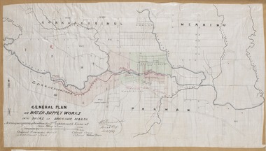
Map, General Plan for Water Supply Works, Shire of Bacchus Marsh 1887
... Maps...Water Supply Bacchus Marsh...A single page paper map showing a general plan for the supply of water in the Bacchus Marsh area.The plan shows the route of the 'Main Channel' near the Werribee River and a proposed route for a Parwan Channel. ...General Plan for Water Supply Works, Shire of Bacchus Marsh 1887 Map Shire of Bacchus Marsh ...Debate about water supply and its planning and development took place in the Bacchus Marsh region from the 1850s through into the twentieth century. This plan was part of documentation to support an application for an additional loan of money from the Ministry of Water Supply to the Bacchus Marsh Shire Water Supply Trust. The plan includes the route of a proposed water channel in the Parwan area, and other features of water supply infrastructure such as the location of standpipes and gates are also shown on the plan.A single page paper map showing a general plan for the supply of water in the Bacchus Marsh area.The plan shows the route of the 'Main Channel' near the Werribee River and a proposed route for a Parwan Channel. The location of 'Dryden's House' near the Werribee River is also shown and the locations of land held by T. (Tom) Oliver and the Racecourse Reserve in Maddingley. Scale 40 chains to 1 inch. The plan is signed by Bacchus Marsh Shire Engineer, W.E. Standfield. The map is pasted into a bound volume containing 76 maps or plans in total. High resolution digital image stored on BMDHS computer network. General Plan of Water Supply Works in the Shire of Bacchus Marsh. Accompanying application for 2nd additional Loan. Original Waterworks district. Additional area. W.E. Standfield, 30/8/87.water supply, water supply maps, water supply bacchus marsh, irrigation, bacchus marsh victoria maps -
 Bacchus Marsh & District Historical Society
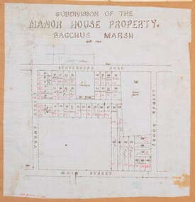
Map, Subdivision of the Manor House Property Bacchus Marsh c.1908
... Maps...Land Sales Bacchus Marsh...The map shows portions of land for sale from the subdivision of the Manor House property in Bacchus Marsh in 1908. ...maps or plans in total. High resolution digital image stored on BMDHS computer network. Subdivision of the Manor House Property Bacchus Marsh c.1908 Map Shire of Bacchus Marsh ...This land sales plan shows allotments of land offered for sale in the inner township area of Bacchus Marsh in 1908. The land put up for sale was from the estate of the late Mr and Mrs J.E. Crook. That being James Elijah Crook and his wife Harriet, (nee Athorn). The Crooks had been resident in Bacchus Marsh since the 1840s and were prominent members of the community. They were prominent in the business, social and civic affairs of the town and district. In the 1850s the Crooks acquired the Manor House and nearby land once owned by the Bacchus family. James Crook died in 1889. When Harriet Crook died in February 1908 their estate was offered for sale. This included the large stone home known as the Manor House and various parcels of land including around 50 allotments of land near the Manor House, bounded by Young, Lerderderg, Crook and Main Streets. Most of these allotments of land were sold in October 1908. The Manor House itself was passed in at the sale and continued to be owned by the Crook family for several decades after 1908.A single page map on a single page of a bound volume of maps. The map shows portions of land for sale from the subdivision of the Manor House property in Bacchus Marsh in 1908. The names of most of the buyers of the portions of land have been hand-written into the various allotments they purchased. The maps are pasted into a bound volume containing 76 maps or plans in total. High resolution digital image stored on BMDHS computer network. bacchus marsh victoria maps, land sales bacchus marsh, manor house bacchus marsh, crook family bacchus marsh -
 Bacchus Marsh & District Historical Society
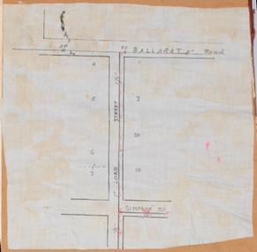
Map, Lord Street, Bacchus Marsh. Undated
... Maps...Lord Street Bacchus Marsh Maps...A small single page map showing the line of Lord Street Bacchus Marsh between Ballarat Road (Main Street) and Simpson Street. ...Bacchus Marsh & District Historical Society Lerderderg Library Main Street Bacchus Marsh Bacchus Marsh Victoria Maps Lord Street Bacchus Marsh Maps A small single page map showing the line of Lord Street Bacchus Marsh between Ballarat Road (Main Street) and Simpson Street. ...A small single page map showing the line of Lord Street Bacchus Marsh between Ballarat Road (Main Street) and Simpson Street. Part of a set of maps which are pasted into a bound volume containing 76 maps or plans in total. High resolution digital image stored on BMDHS computer network. bacchus marsh victoria maps, lord street bacchus marsh maps -
 Bacchus Marsh & District Historical Society
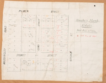
Map, Bacchus Marsh Estate sold 30th June 1888 and sold 28 December 1895
... Maps...Land Sales Bacchus Marsh...Blocks of land in this area of Bacchus Marsh were sold in lots between 1888 and the late 1890s. This map shows sales made in 1888 and 1895....maps or plans in total. High resolution digital image stored on BMDHS computer network. Bacchus Marsh Estate sold 30th June 1888 and sold 28 December 1895 Map Shire of Bacchus Marsh ...Blocks of land in this area of Bacchus Marsh were sold in lots between 1888 and the late 1890s. This map shows sales made in 1888 and 1895.Single page map showing allotments of land bounded by Pilmer Street, Graham Street, Sydney Street and Maddingley Road (Grant Street) in Bacchus Marsh.The area is dissected by Como Street down the central area. 43 blocks of land are shown with the names of buyers or sellers in 1888 written in black in. Buyers or sellers for December 1895 are written in red ink. Part of a set of maps which are pasted into a bound volume containing 76 maps or plans in total. High resolution digital image stored on BMDHS computer network. bacchus marsh victoria maps, land sales bacchus marsh, pilmer street bacchus marsh, graham street bacchus marsh, sydney street bacchus marsh, como street bacchus marsh, maddingley road bacchus marsh, grant street bacchus marsh -
 Bacchus Marsh & District Historical Society
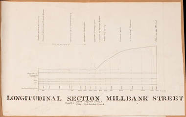
Drawing, Longitudinal Section Millbank Street Bacchus Marsh circa 1905
... Maps...Millbank Street Bacchus Marsh...Bacchus Marsh. The names of Millbank Street property owners, Cain, Shelley, Oliver and Ramsay are marked on this plan. Scale: Vertical 10 feet to 1 inch. Horizontal: 100 links to 1 inch Part of a set of maps...Bacchus Marsh & District Historical Society Lerderderg Library Main Street Bacchus Marsh Millbank Street is a short street located close to the central business and shopping area of Bacchus Marsh. In the early 1900s works to improve the drainage of the street were discussed and planned by Bacchus Marsh Shire Council. This plan is most probably the plan discussed at a Shire Council meeting in April 1905. Bacchus Marsh Victoria Maps ...Millbank Street is a short street located close to the central business and shopping area of Bacchus Marsh. In the early 1900s works to improve the drainage of the street were discussed and planned by Bacchus Marsh Shire Council. This plan is most probably the plan discussed at a Shire Council meeting in April 1905. Single page plan showing a longitudinal section view of MIllbank Street running from Clarinda Street to Grant Street in Bacchus Marsh. The names of Millbank Street property owners, Cain, Shelley, Oliver and Ramsay are marked on this plan. Scale: Vertical 10 feet to 1 inch. Horizontal: 100 links to 1 inch Part of a set of maps which are pasted into a bound volume containing 76 maps or plans in total. High resolution digital image stored on BMDHS computer network. bacchus marsh victoria maps, millbank street bacchus marsh -
 Bacchus Marsh & District Historical Society
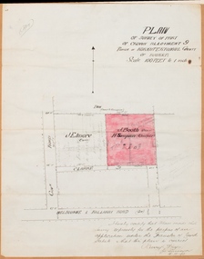
Map, Plan of Survey of Part of Crown Allotment 9, Parish of Korkuperrimul, 1890
... Maps...Clarke Street Bacchus Marsh Maps...This map documents a transfer of an allotment of land in Clarke Street Bacchus Marsh in 1890. ...Elmore, Bacchus Marsh Victoria Maps Clarke Street Bacchus Marsh Maps At bottom of map: I hereby certify that I have made this survey expressly for the purpose of an application under the Transfer of Land Statute that this plan is correct. ...This map documents a transfer of an allotment of land in Clarke Street Bacchus Marsh in 1890. Clarke Street is located on the eastern side of Bacchus Marsh not far from Main Street and Crook Street. It is now known as Candeloro Street. The map indicates J. Booth as the owner of the land and H. Simpson as the occupier. Next to this allotment is a an allotment of land owned by J. Elmore,Single page map showing Crown allotment 9, Parish of Korkuperrimul, County of Bourke. Scale 100 feet to inch. Part of a set of maps which are pasted into a bound volume containing 76 maps or plans in total. High resolution digital image stored on BMDHS computer network. At bottom of map: I hereby certify that I have made this survey expressly for the purpose of an application under the Transfer of Land Statute that this plan is correct. Barry B???, Lic. Surveyor, 16.10.90bacchus marsh victoria maps, clarke street bacchus marsh maps -
![Map, Liquidator's sale, 1896. [Woolpack Estate, Bacchus Marsh]](/media/collectors/5e461d8021ea67224c82f2a1/items/6779ee97032b72846b5995f2/item-media/6779ef33032b72846b599b30/item-fit-380x285.jpg?cb=6) Bacchus Marsh & District Historical Society
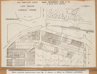
Bacchus Marsh & District Historical SocietyMap, Liquidator's sale, 1896. [Woolpack Estate, Bacchus Marsh]
... Maps...Woolpack Estate Bacchus Marsh Victoria...Most of the blocks of land were sold for higher than expected prices and most of the buyers were people from the town and district of Bacchus Marsh. The map includes various details about the land which is described on the map as an "important sale of rich alluvial irrigable flat land in the Bacchus Marsh Valley, and other properties". ...Also shown on the map are lots for sale at Robinson's Farm on Coimadai Creek and allotments near Bacchus Marsh railway station, including lots on Government Road (East Maddingley Road), View Street and Government Road (Parwan Road). ...] Map Shire of Bacchus Marsh ...The Woolpack Estate was an area of land owned by various landowners in the Bacchus Marsh area since the early Colonial period of the 1840s. The area was located on the eastern side of the Bacchus Marsh township about 7 kilometers from the town. The Lerderderg River ran through part of the land and so did the Melbourne to Ballarat Road. The historic Woolpack Inn associated with James Crook was also located on this land. By 1896 150 acres of this land was under the control of liquidators for the Federal Bank of Australasia who instructed that the land be sub-divided and sold in lots by public auction. A successful sale was held on 24 June 1896. Most of the blocks of land were sold for higher than expected prices and most of the buyers were people from the town and district of Bacchus Marsh. The map includes various details about the land which is described on the map as an "important sale of rich alluvial irrigable flat land in the Bacchus Marsh Valley, and other properties". The auction was conducted by the local agents W. Anderson and Bence in conjunction with Pearce Brothers also of Bacchus Marsh.A single page paper map showing a plan of 150 acres of land from the Woolpack Estate to be sold in various lots in June 1896. Also shown on the map are lots for sale at Robinson's Farm on Coimadai Creek and allotments near Bacchus Marsh railway station, including lots on Government Road (East Maddingley Road), View Street and Government Road (Parwan Road). No scale provided. The map is pasted into a bound volume containing 76 maps or plans in total. High resolution digital image stored on BMDHS computer network. land sales bacchus marsh, bacchus marsh victoria maps, woolpack estate bacchus marsh victoria -
 Bacchus Marsh & District Historical Society
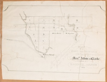
Map, Plan of the second portion of the property of Messers Atkins and Clarke situate at Bacchus Marsh 1856
... BMDHS Loc: AR/B12/S4 Bacchus Marsh Township and Nearby Districts Maps Volume In-house Digital copies: BMDHS, Computer Network: Maps\Bacchus Marsh Township and Nearby Districts Maps Volume...BMDHS Loc: AR/B12/S4 Bacchus Marsh Township and Nearby Districts Maps Volume In-house Digital copies: BMDHS, Computer Network: Maps\Bacchus Marsh Township and Nearby Districts Maps Volume Plan of the second portion of the property of Messers Atkins and Clarke situate at Bacchus Marsh 1856 Map Shire of Bacchus Marsh ...This plan of land allotments for sale indicates part of the property once owned by the Bacchus family in and around the township area of Bacchus Marsh. The Bacchus family sold their property in Bacchus Marsh to John Aitkins and Robert Nalder Clarke in March 1851. Aitkins and Clarke kept the property for a number of years until April 1856 when these allotments were put up for sale.This is a very early land sales plan for agricultural land close to the township of Bacchus Marsh. It therefore provides some clues as to how the early urban development of the township and agricultural development of the nearby area took place. Upon seeing the map in 1911 Bacchus Marsh Express newspaper editor Christopher Crisp wrote "The sale appears to have created the present township, which had a nucleus in earlier times further east", Express, 30 September, 1911, page 3.A single page paper plan showing allotments of land for sale. The subdivided land shown was owned by John Aitkins and Robert Nalder Clarke, but previously owned by the Bacchus Family and was in and around their Manor House (Mansion) property in Bacchus Marsh. This plan shows allotments in the second portion of land to be sold which was located east of the Manor House on the eastern side of the Lerderderg River. The land for sale was made up of 15 allotments. The plan is pasted into a bound volume containing 76 maps or plans in total. BMDHS Loc: AR/B12/S4 Bacchus Marsh Township and Nearby Districts Maps Volume In-house Digital copies: BMDHS, Computer Network: Maps\Bacchus Marsh Township and Nearby Districts Maps Volumebacchus marsh victoria maps, bacchus family, land sales, manor house bacchus marsh -
 Bacchus Marsh & District Historical Society
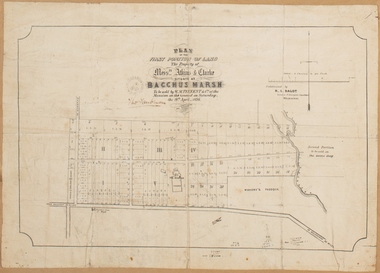
Map, Plan of the property of Messers Atkins and Clarke to be sold at the Mansion, Bacchus Marsh 19th April 1856. Copy 1
... Township and Nearby Districts Maps Volume In-house Digital copies: BMDHS, Computer Network: Maps\Bacchus Marsh Township and Nearby Districts Maps Volume...Copy 1 Map Shire of Bacchus Marsh ...This plan of land allotments for sale indicates the property once owned by the Bacchus family in and around the township area of Bacchus Marsh. The Bacchus family sold their property in Bacchus Marsh to John Atkins and Robert Nalder Clarke in March 1851. Atkins and Clarke kept the property for a number of years until April 1856 when these allotments were put up for sale.This plan is almost identical to another copy held by the Bacchus Marsh and District Historical Society, VC Record 452, BMDHS collection). This plan, VC Record 707 Copy 1, contains a little more detail overall than VC Record 452 Copy 2, such as who did the survey work for the plan (R.C. Bagot) and who the selling agents were, (W.M. Tennent), and on the right side of the plan near the Lerderderg River is indicated the general area for a second parcel of land from this sale which is to be sold. There is also a compass illustration indicating north and south compass points.This is a very early land sales plan for the township of Bacchus Marsh and it therefore provides some clues as to how the early urban development of the township took place. Upon seeing the map in 1911 Bacchus Marsh Express newspaper editor Christopher Crisp wrote "The sale appears to have created the present township, which had a nucleus in earlier times further east", Express, 30 September, 1911, page 3.A single page paper plan showing allotments of land for sale. The subdivided land shown was owned by John Atkins and Robert Nalder Clarke, but previously owned by the Bacchus Family and was in and around their Manor House (Mansion) property in Bacchus Marsh.There are 5 portions of land further divided into numerous small portions. The land for sale is bounded by the present day streets of Main Street, Young Street, McFarland Street, Morton Streets, Crook Street, and part of the eastern section extends to the Lerderderg River. Scale: 8 chains to 1 inch The plan is pasted into a bound volume containing 76 maps or plans in total. BMDHS Loc: AR/B12/S4 Bacchus Marsh Township and Nearby Districts Maps Volume In-house Digital copies: BMDHS, Computer Network: Maps\Bacchus Marsh Township and Nearby Districts Maps VolumeHeading: Plan of the first portion of land. The property of Messers Atkins and Clarke situate at Bacchus Marsh. To be sold by W.M. Tennent & Co. at the Mansion on the Ground on Saturday the 19th April 1856. Below heading: Jas Ferguson, Lithographer On upper right side: Subdivided by R.C. Bagot London and Liverpool Chambers, Melbourne. 'Thos Taubman'. Post Office Stamp: BACCHUS MARSH VICTORIA MY 6, 63bacchus marsh victoria maps, bacchus family, land sales, manor house bacchus marsh -
 Bacchus Marsh & District Historical Society
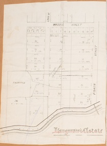
Map, Langmann's Estate Bacchus Marsh
... Little upon of a portion of the map. Little was Bacchus Marsh Shire Secretary and Engineer between 1886 and 1914 which dates the map to some time between 1886 and 1914....maps or plans in total. High resolution digital image stored on BMDHS computer network. Langmann's Estate Bacchus Marsh Map Shire of Bacchus Marsh ...The date of this map has not been determined. It bears the signature of D.A. Little upon of a portion of the map. Little was Bacchus Marsh Shire Secretary and Engineer between 1886 and 1914 which dates the map to some time between 1886 and 1914.A single page paper map showing a portions of land in part of Bacchus Marsh.The area shown is described as Langmann's Estate. The area is bounded by the Werribee River, Fisken Street, Waddle Street(sic.) (Waddell) and Lord Street. The map is pasted into a bound volume containing 76 maps or plans in total. High resolution digital image stored on BMDHS computer network. bacchus marsh victoria maps -
 Bacchus Marsh & District Historical Society
Map, Gaynor Street Land Sales, Maddingley, circa 1880s-1890s
... This map was produced for a major sale of land in the Maddingley area of Bacchus Marsh. ...A single page paper map showing land allotments for sale in the Maddingley area of Bacchus Marsh. Locations shown include Gaynor Street, Maddingley Road South, Parwan Road, Mitchem Street, Typpynge Street, Finn Street and East Maddingley Road. . ...Bacchus Marsh & District Historical Society Lerderderg Library Main Street Bacchus Marsh This map was produced for a major sale of land in the Maddingley area of Bacchus Marsh. ...This map was produced for a major sale of land in the Maddingley area of Bacchus Marsh. The precise date of the sale has not been determined. Features present on the map such as the Bacchus Marsh Railway Station indicate the land sale must have taken place some time after 1887 when the Railway Station opened. A single page paper map showing land allotments for sale in the Maddingley area of Bacchus Marsh. Locations shown include Gaynor Street, Maddingley Road South, Parwan Road, Mitchem Street, Typpynge Street, Finn Street and East Maddingley Road. . The map is pasted into a bound volume containing 76 maps or plans in total. High resolution digital image stored on BMDHS computer network. bacchus marsh victoria maps, maddingley victoria maps, land use, maddingley victoria history, land sales bacchus marsh, land sales maddingley -
 Bacchus Marsh & District Historical Society
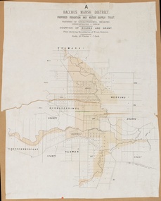
Map, Bacchus Marsh District (A). Proposed Irrigation and Water Supply Trust. Plan shewing boundaries of Trust District
... The Bacchus Marsh Irrigation and Water Supply Trust was formed in 1889. This map depicts the proposed area of the Trust....Printed paper map of the proposed Bacchus Marsh Irrigation and Water Supply district. ...Irrigation Water Supply Bacchus Marsh Irrigation and Water Supply Trust Printed paper map of the proposed Bacchus Marsh Irrigation and Water Supply district. ...The 1886 Irrigation Act in Victoria introduced the first legislation in Australia designed to enable the creation of a detailed scheme for agricultural irrigation. Part of the legislation saw the use of government funds for local irrigation projects. These local projects were managed by local irrigation trusts. The Bacchus Marsh Irrigation and Water Supply Trust was formed in 1889. This map depicts the proposed area of the Trust.Printed paper map of the proposed Bacchus Marsh Irrigation and Water Supply district. Circa 1889. Plan showing boundaries of Trust District. The District lies within the Parishes of Korkuperrimul, Merrimu, Parwan and Gorrockburkchap in the Counties of Bourke and Grant. At the top of the map above its title is the letter 'A; in capital lettering. Scale: 40 Chains = 1 inch.irrigation, water supply, bacchus marsh irrigation and water supply trust -
 Bacchus Marsh & District Historical Society
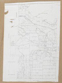
Map, Maddingley Township, Parish of Parwan, circa 1890s
... Maddingley is a locality or township within the broader township area of Bacchus Marsh. This map is not dated. However features in Maddingley which appeared in the 1880s and 1890s are present in the map, These include the Bacchus Marsh Railway Station and the Bacchus Marsh Showgrounds. ...A single page paper map showing land allotments, streets, rivers, creeks, park lands, the railway line and Bacchus Marsh railway station in the township of Maddingley. ...Maddingley Township, Parish of Parwan, circa 1890s Map Shire of Bacchus Marsh ...Maddingley is a locality or township within the broader township area of Bacchus Marsh. This map is not dated. However features in Maddingley which appeared in the 1880s and 1890s are present in the map, These include the Bacchus Marsh Railway Station and the Bacchus Marsh Showgrounds. The main residential and commercial area of Maddingley is shown on this map in an area bounded by Bacchus Street, Barry Street, Griffith Street and Maddingley Road. Other streets visible are Franklin Street, Inglis Street, Labilliere Street, McCrae Street, Moore Street and part of Station Street.A single page paper map showing land allotments, streets, rivers, creeks, park lands, the railway line and Bacchus Marsh railway station in the township of Maddingley. The map is pasted into a bound volume containing 76 maps or plans in total. bacchus marsh victoria maps, maddingley victoria maps, land use, maddingley victoria history -
 Eltham District Historical Society Inc
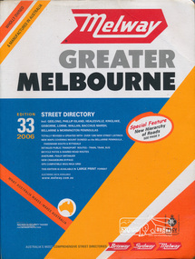
Book, Melway Publishing, Melway Greater Melbourne street directory : including Geelong, Phillip Island, Healesville, Kinglake, Gisborne, Lorne, Wallan, Bacchus Marsh Bellarine & Mornington Peninsulas; Edition 33, 2006, 2005
... Eastlink fully detailed new Craigieburn bypass GPS compatible WGS/MGA Grid Special feature: New Hierachy of Roads streets,roads,melbourne,map,melway Street directory with plastic cover, coloured maps, 902 pages Melway Greater Melbourne street directory : including Geelong, Phillip Island, Healesville, Kinglake, Gisborne, Lorne, Wallan, Bacchus Marsh Bellarine & Mornington Peninsulas; Edition 33, 2006 Book Melway Publishing ...Edition 33. 2006 Coloured detailed maps accessed by a street or location index. Cover: Totally revised and updated with over 1380 new street listings new maps covering Mount Duneed on the Bellarine Peninsula, Pakenham South and Rythdale. Detailed public transport routes - train, tram, bus, bicycle paths & shared road routes. Eastlink fully detailed new Craigieburn bypass GPS compatible WGS/MGA Grid Special feature: New Hierachy of Roads Street directory with plastic cover, coloured maps, 902 pagesstreets,roads,melbourne,map,melway -
 Federation University Historical Collection
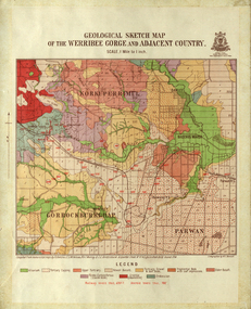
Map, Geological Sketch Map of the Werribee Gorge and Adjacent Country, 1914, 1914
... A coloured geological sketch map of the Werribee Gorge, Bacchus Marsh, Rowlesy, Darley, Parwan. ...Barker Library (top floor) Mount Helen goldfields werribee gorge bacchus marsh darley parwan w.e. bennett bennett r.a.f. murray c.c. brittlebank rowsley A coloured geological sketch map of the Werribee Gorge, Bacchus Marsh, Rowlesy, Darley, Parwan. ...A coloured geological sketch map of the Werribee Gorge, Bacchus Marsh, Rowlesy, Darley, Parwan. The scale is 1 mile to 1 inchwerribee gorge, bacchus marsh, darley, parwan, w.e. bennett, bennett, r.a.f. murray, c.c. brittlebank, rowsley -
 Ballarat Tramway Museum
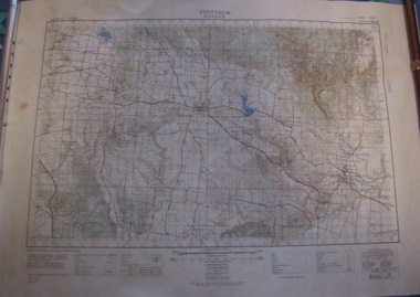
Map, Australian Survey Corps, "Victoria Ballan", 1933
... Topographic map of the Ballan area - includes Bacchus Marsh and Bungaree, No. 837, Zone 7, Army Map, dated 1933, 1:63360. ...Ballarat Tramway Museum South Gardens Reserve Wendouree Parade Ballarat Ballarat goldfields Trams tramways Bungaree Map Topographic map of the Ballan area - includes Bacchus Marsh and Bungaree, No. 837, Zone 7, Army Map, dated 1933, 1:63360. ...Topographic map of the Ballan area - includes Bacchus Marsh and Bungaree, No. 837, Zone 7, Army Map, dated 1933, 1:63360. Shows rail lines, roads, elevations, contours. Collected with relevance to the Museum's association with the area, at Bungareetrams, tramways, bungaree, map -
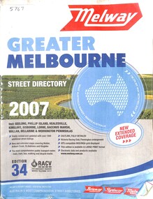 Sunshine and District Historical Society Incorporated
Book - Melway Greater Melbourne Street Directory 2007, Melway Publishing Pty Ltd, 2007
... maps of Great Melbourne area. In this Melway the coverage extends from Wallan, Whittlesea and Kinglake in the North to Mornington Peninsula in the South, Warburton and Tynong in the East to Bacchus Marsh and Geelong in the West. ...The series of Melway Directories provides the most comprehensive maps of Great Melbourne area. In this Melway the coverage extends from Wallan, Whittlesea and Kinglake in the North to Mornington Peninsula in the South, Warburton and Tynong in the East to Bacchus Marsh and Geelong in the West. Regional areas of Gisborne, Torquay, Anglesea, Lorne and Phillip Island are also included. Past editions of the Melway can provide invaluable material for researchers and historians.Paper back book with plastic jacketnon-fictionThe series of Melway Directories provides the most comprehensive maps of Great Melbourne area. In this Melway the coverage extends from Wallan, Whittlesea and Kinglake in the North to Mornington Peninsula in the South, Warburton and Tynong in the East to Bacchus Marsh and Geelong in the West. Regional areas of Gisborne, Torquay, Anglesea, Lorne and Phillip Island are also included. Past editions of the Melway can provide invaluable material for researchers and historians. -
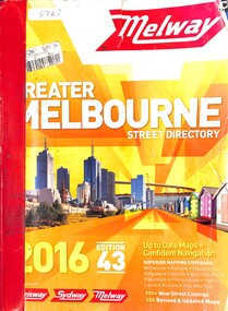 Sunshine and District Historical Society Incorporated
Book - Melway Greater Melbourne Street Directory 2016, Melway Publishing Pty Ltd, 2016
... maps of Great Melbourne area. In this Melway the coverage extends from Wallan, Whittlesea and Kinglake in the North to Mornington Peninsula in the South, Warburton and Tynong in the East to Bacchus Marsh and Geelong in the West. ...The series of Melway Directories provides the most comprehensive maps of Great Melbourne area. In this Melway the coverage extends from Wallan, Whittlesea and Kinglake in the North to Mornington Peninsula in the South, Warburton and Tynong in the East to Bacchus Marsh and Geelong in the West. Regional areas of Kilmore, Macedon, Gisborne, Riddells Creek, Bannockburn, Torquay, Anglesea, Lorne, Phillip Island and Koo Wee Rup are also included. Past editions can provide invaluable material for researchers and historians.Paper back booknon-fictionThe series of Melway Directories provides the most comprehensive maps of Great Melbourne area. In this Melway the coverage extends from Wallan, Whittlesea and Kinglake in the North to Mornington Peninsula in the South, Warburton and Tynong in the East to Bacchus Marsh and Geelong in the West. Regional areas of Kilmore, Macedon, Gisborne, Riddells Creek, Bannockburn, Torquay, Anglesea, Lorne, Phillip Island and Koo Wee Rup are also included. Past editions can provide invaluable material for researchers and historians. -
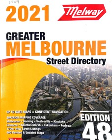 Sunshine and District Historical Society Incorporated
Book - Melway Greater Melbourne Street Directory 2021, Melway Publishing Pty Ltd, 2021
... maps of Great Melbourne area. In this Melway the coverage extends from Wallan, Whittlesea and Kinglake in the North to Mornington Peninsula in the South, Warburton and Tynong in the East to Bacchus Marsh and Geelong in the West. ...The series of Melway Directories provides the most comprehensive maps of Great Melbourne area. In this Melway the coverage extends from Wallan, Whittlesea and Kinglake in the North to Mornington Peninsula in the South, Warburton and Tynong in the East to Bacchus Marsh and Geelong in the West. Regional areas of Kilmore, Macedon, Gisborne, Riddells Creek, Bannockburn, Torquay, Anglesea, Lorne, Phillip Island and Koo Wee Rup are also included. Past editions of the Melway can provide invaluable material for researchers and historians.Paper back booknon-fictionThe series of Melway Directories provides the most comprehensive maps of Great Melbourne area. In this Melway the coverage extends from Wallan, Whittlesea and Kinglake in the North to Mornington Peninsula in the South, Warburton and Tynong in the East to Bacchus Marsh and Geelong in the West. Regional areas of Kilmore, Macedon, Gisborne, Riddells Creek, Bannockburn, Torquay, Anglesea, Lorne, Phillip Island and Koo Wee Rup are also included. Past editions of the Melway can provide invaluable material for researchers and historians.