Showing 608 items matching "margaret roberts"
-
 Bendigo Historical Society Inc.
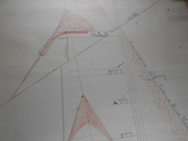
Plan - South Frederick The Great Mine, Sebastian
... ...Margaret Roberts...Forms part of the Margaret Roberts Collection of mining records....Forms part of the Margaret Roberts Collection of mining records. Plan South Frederick The Great Mine, Sebastian, ...SOUTH FREDERICK THE GREAT MINE Location Unreserved Crown Land along the southern boundary of Sebastian School, east of Three Chain Road, Frederick the Great/Carshalton Reef, Sebastian Map Reference Raywood 1:25000 - BV488.447 Mine site: Capped shaft still surrounded by its mullock paddock. At the base of the paddock on the northern side is a concrete winding engine foundation measuring 8 by 4 feet, and standing 2 feet high. The foundation has ¾-inch mounting bolts. Battery site 70 metres to the west of the mine site are the concrete foundations of a 10head battery. The foundations measure 16 by 11 feet, and stand 4 feet high. Part of the battery's loading ramp still survives, and on the eastern side of the battery foundations is a large concrete engine foundation. Near this engine foundation is a 3 foot square concrete pad, which still retains a circular impression. Presumably this was a stand for a gas producer cylinder. Located between the battery and the mine site is a rubbish dump which contains sections of an iron stack, and perhaps the remains of the gas producer cylinder. History Period of activity: 1871 (South Frederick the Great); 1881-1889 (Amalgamated South Frederick the Great); 1897-1906 (South Frederick the Great); 1933-1937 (South Frederick the Great) Line of reef: Sebastian/Carshalton Maximum recorded annual production: unknown Total production: 511ozs obtained from 1773 tons between 1934 and 1937 Deepest working level: 300 feet (Amalgamated South Frederick the Great) Deepest shaft: 307 feet (Amalgamated South Frederick the Great)(below water level) Source: City of Greater Bendigo: Marong Heritage Study chrome-extension://efaidnbmnnnibpcajpcglclefindmkaj/http://images.heritage.vic.gov.au/attachment/70493Mining SitesTransverse and longitudinal plans on one sheet, of South Frederick The Great Mine, Sebastian. Forms part of the Margaret Roberts Collection of mining records.bendigo, margaret roberts, gold, south frederick the great mine, margaret roberts collection, sebastian -
 Bendigo Historical Society Inc.
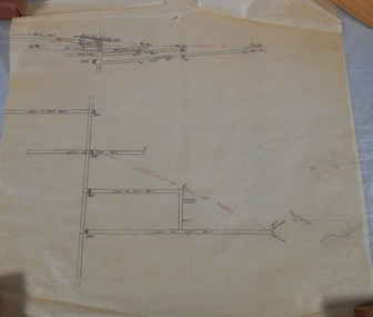
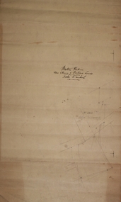
Plan - Mine Map
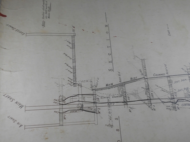
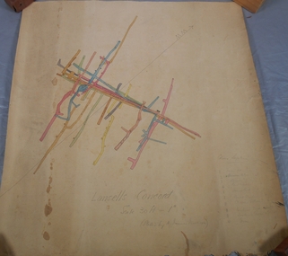
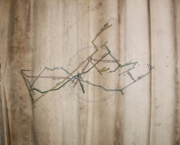
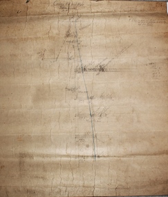
... ...Margaret Roberts...Forms part of the Margaret Roberts Collection of mining records....Forms part of the Margaret Roberts Collection of mining records. Plan Mine Map ...Transverse section of un-named mine showing underground workings and geological features. Forms part of the Margaret Roberts Collection of mining records.bendigo, margaret roberts, gold, map, mine, margaret roberts collection -
 Bendigo Historical Society Inc.
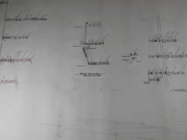
Plan - Confidence Cornish Kochs & Windmill Hill
... ...Margaret Roberts...Forms part of the Margaret Roberts Collection of mining records....Forms part of the Margaret Roberts Collection of mining records. Plan Confidence Cornish Kochs & Windmill Hill ...Koch's Pioneer Gold Mine: Koch's Pioneer Quartz Mining and Crushing Company was officially registered on June 30th., 1871 (Government Gazette No. 45, 1871). It operated at Long Gully, the first Manager was Andrew Lewis. Nominal capital was 90,000 pounds in thirty thousand shares of 3 pounds each. The initial partnership in a quartz crushing plant between Henry Koch, Simon Albert and Charles Wallin was dissolved in 1860 with Koch becoming the sole owner. In 1866 the crushing plant consisted of a 50 hp engine and 48 stamping heads capable of crushing 600 tons of quartz per week. By 1902 there were 72 stamps and this was by far the largest crushing plant in the area, serving many quartz mines. Henry Koch (1800-1889) was a German sailor who signed off when his ship reached Melbourne in 1851. Having heard of the gold discovery he proceeded to Bendigo where he was initially employed in puddling in the Myers Flat area. He was soon employed and then made partner in a quartz crushing plant that he became sole owner of in 1860. He was also landlord at the British and American Hotel and the Silver Mines Hotel. HE also started the Perseverance United gold claim. He married Anna Maria Theresia Heinz in 1857. In 1872 he sold the crushing plant for 75,000 pounds and took his family back to Germany. He resumed his trade as a ship builder although he maintained many Bendigo mining interests.Draftsman's drawing Confidence, Cornish, Kochs & Windmill Hill Long and Transverse Sections. Forms part of the Margaret Roberts Collection of mining records.bendigo, margaret roberts, gold, map, mine, margaret roberts collection, confidence cornish kochs & windmill hill -
 Bendigo Historical Society Inc.
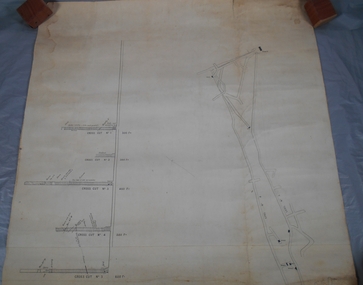
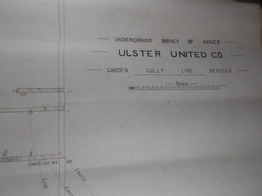
Plan - Ulster United Co
... ...Margaret Roberts...Forms part of the Margaret Roberts Collection of mining records....History House 11 Mackenzie Street Bendigo goldfields Bendigo Margaret Roberts gold Map Mine Ulster United Co Margaret Roberts Collection Draftsman's drawing Underground Survey of Mines Ulster United Co. ...Draftsman's drawing Underground Survey of Mines Ulster United Co. Garden Gully Line Bendigo Map. Forms part of the Margaret Roberts Collection of mining records.bendigo, margaret roberts, gold, map, mine, ulster united co, margaret roberts collection -
 Bendigo Historical Society Inc.
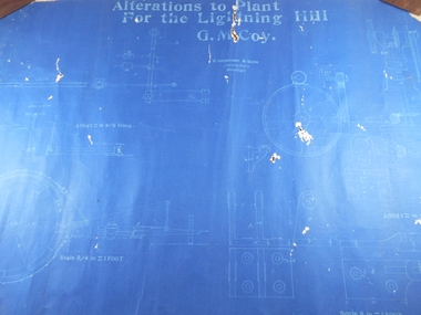
Administrative record - Lightning Hill Coy
... ...Margaret Roberts...Forms part of the Margaret Roberts Collection of mining records....Forms part of the Margaret Roberts Collection of mining records. Administrative record Lightning Hill Coy ...Draftsman's drawing Lightning Hill Coy Map. Forms part of the Margaret Roberts Collection of mining records.bendigo, margaret roberts, gold, map, mine, lightning hill coy -
 Bendigo Historical Society Inc.
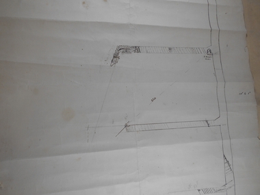
Plan - South Frederick The Great Mine, Sebastian, Mine map
... ...Margaret Roberts...Forms part of the Margaret Roberts Collection of mining records....Forms part of the Margaret Roberts Collection of mining records. Plan South Frederick The Great Mine, Sebastian, Mine map ...Draftsman's drawing of South Frederick The Great Mine, Sebastian. Forms part of the Margaret Roberts Collection of mining records.Pencil markings additions to mapbendigo, margaret roberts, gold, map, south frederick the great mine -
 Bendigo Historical Society Inc.
Plan - St Mungo Co
... ...Margaret Roberts...Forms part of the Margaret Roberts Collection of mining records....Forms part of the Margaret Roberts Collection of mining records. Plan St Mungo Co ...Draftsman's drawing St Mungo Co Mine Map. Forms part of the Margaret Roberts Collection of mining records.bendigo, margaret roberts, gold, map, mine, st mungo co -
 Bendigo Historical Society Inc.
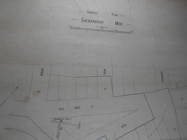
Administrative record - Shenandoah Mine Surface plan
... ...Margaret Roberts...Forms part of the Margaret Roberts Collection of mining records....Forms part of the Margaret Roberts Collection of mining records. Administrative record Shenandoah Mine Surface plan ...Draftsman's drawing Shenandoah Mine Surface Plan Map. Forms part of the Margaret Roberts Collection of mining records.bendigo, margaret roberts, gold, map, mine, shendandoah mine -
 Bendigo Historical Society Inc.
Administrative record - Central Blue Section
... ...Margaret Roberts...Forms part of the Margaret Roberts Collection of mining records....Bendigo Margaret Roberts gold Map Mine Central Blue Section Draftsman's drawing Central Blue Section Mine Map. ...Draftsman's drawing Central Blue Section Mine Map. Forms part of the Margaret Roberts Collection of mining records.bendigo, margaret roberts, gold, map, mine, central blue section -
 Bendigo Historical Society Inc.
Administrative record - Lightning Hill Coy
... ...Margaret Roberts...Forms part of the Margaret Roberts Collection of mining records....Forms part of the Margaret Roberts Collection of mining records. Administrative record Lightning Hill Coy ...Draftsman's drawing Alterations to Lightning Hill Coy plan Map. Forms part of the Margaret Roberts Collection of mining records.bendigo, margaret roberts, gold, map, mine, lightning hill coy -
 Bendigo Historical Society Inc.
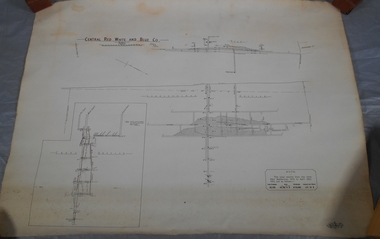
Administrative record - Central Red White and Blue Mine
... ...Margaret Roberts...Forms part of the Margaret Roberts Collection of mining records....Forms part of the Margaret Roberts Collection of mining records. Administrative record Central Red White and Blue Mine ...Draftsman's drawing Central Red, White, and Blue Mine Map. Forms part of the Margaret Roberts Collection of mining records.bendigo, margaret roberts, gold, map, mine, central red white and blue -
 Bendigo Historical Society Inc.
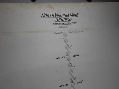
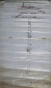
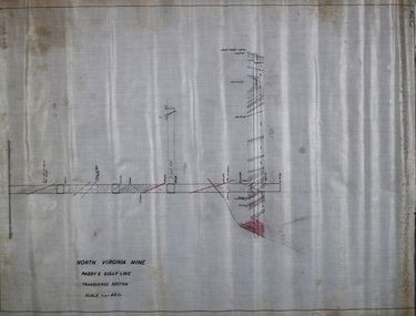
Administrative record - North Virginia Mine Bendigo Transverse Section
... ...Margaret Roberts...Forms part of the Margaret Roberts Collection of mining records....Bendigo Margaret Roberts gold Map Mine North Virginia Mine Bendigo Draftsman's drawing North Virginia Mine Transverse Section Map. ...Draftsman's drawing North Virginia Mine Transverse Section Map. Forms part of the Margaret Roberts Collection of mining records.bendigo, margaret roberts, gold, map, mine, north virginia mine bendigo -
 Bendigo Historical Society Inc.
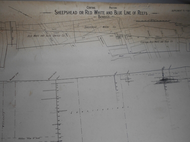
Administrative record - Sheepshead or Red White and Blue Mine
... ...Margaret Roberts...Forms part of the Margaret Roberts Collection of mining records....Forms part of the Margaret Roberts Collection of mining records. Administrative record Sheepshead or Red White and Blue Mine ...Draftsman's drawing Sheepshead or Red White and Blue Mine Map. Forms part of the Margaret Roberts Collection of mining records. Notes in pencil bendigo, margaret roberts, gold, map, mine, sheepshead or red white and blue reef -
 Bendigo Historical Society Inc.
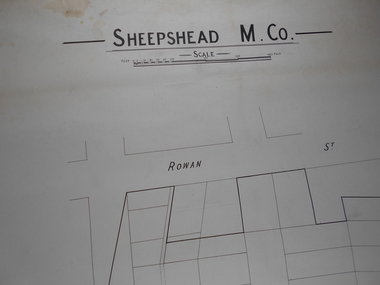
Map - Sheepshead M Co
... ...Margaret Roberts...Rowan Street marked on map Forms part of the Margaret Roberts Collection of mining records....Rowan Street marked on map Forms part of the Margaret Roberts Collection of mining records. Map Sheepshead M Co ...Draftsman's drawing Sheepshead Mine Map. Rowan Street marked on map Forms part of the Margaret Roberts Collection of mining records.bendigo, margaret roberts, gold, map, mine, sheepshead m.co -
 Bendigo Historical Society Inc.
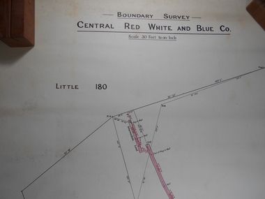
Administrative record - Central Red White and Blue
... ...Margaret Roberts...Draftsman's drawing Boundary Survey Central Red White and Blue Map Forms part of the Margaret Roberts Collection of mining records....History House 11 Mackenzie Street Bendigo goldfields Bendigo Margaret Roberts gold Map Mine Central Red White and Blue Draftsman's drawing Boundary Survey Central Red White and Blue Map Forms part of the Margaret Roberts Collection of mining records. ...Draftsman's drawing Boundary Survey Central Red White and Blue Map Forms part of the Margaret Roberts Collection of mining records.bendigo, margaret roberts, gold, map, mine, central red white and blue -
 Bendigo Historical Society Inc.
Plan - Central Red White and Blue Mine Map
... ...Margaret Roberts...Handwritten signature of Garnet G Buich, Licensed Mining Surveyor Forms part of the Margaret Roberts Collection of mining records....Bendigo Margaret Roberts gold Map Mine Central Red White and Blue Margaret Roberts Collection Draftsman's drawing Boundary Survey of Central Red White and Blue Co Map. ...Draftsman's drawing Boundary Survey of Central Red White and Blue Co Map. Handwritten signature of Garnet G Buich, Licensed Mining Surveyor Forms part of the Margaret Roberts Collection of mining records.bendigo, margaret roberts, gold, map, mine, central red white and blue, margaret roberts collection -
 Bendigo Historical Society Inc.
Administrative record - Lansell's Concord Mine Map
... ...Margaret Roberts...Additional pencil markings for legend Forms part of the Margaret Roberts Collection of mining records....History House 11 Mackenzie Street Bendigo goldfields Bendigo Margaret Roberts gold Map Mine Lansell's Concord Draftsman's drawing Lansells Concord Mine Map. ...Draftsman's drawing Lansells Concord Mine Map. Additional pencil markings for legend Forms part of the Margaret Roberts Collection of mining records.bendigo, margaret roberts, gold, map, mine, lansell's concord -
 Bendigo Historical Society Inc.
Plan - Great Extended Hustlers Mine
... ...Margaret Roberts...Plan of Great Extended Hustlers Mine on a horizontal plane, showing drives shaded in red and blue Forms part of the Margaret Roberts Collection ...May, 1914, when seven men were killed in an underground explosion. Bendigo Margaret Roberts gold Great Extended Hustlers Hustlers Hill Plan of Great Extended Hustlers Mine on a horizontal plane, showing drives shaded in red and blue Forms part of the Margaret Roberts Collection Plan Great Extended Hustlers Mine ...The Great Extended Hustlers Mine was located on the now named 'Hustlers Reserve' on Hustlers Hill, North Bendigo. It was the site of a major mine disaster on 2nd. May, 1914, when seven men were killed in an underground explosion. Plan of Great Extended Hustlers Mine on a horizontal plane, showing drives shaded in red and blue Forms part of the Margaret Roberts Collection bendigo, margaret roberts, gold, great extended hustlers, hustlers hill -
 Bendigo Historical Society Inc.
Plan - Casley's Red White and Blue Mine
... ...Margaret Roberts...Forms part of the Margaret Roberts Collection of mining memorabilia....Forms part of the Margaret Roberts Collection of mining memorabilia. ...Casley's Red White and Blue Gold Mine was located between Burns Street and the Spring Gully Reservoir, Spring Gully. SHEEPSHEAD REEF, DIAMOND HILL, BENDIGO Location BURNS STREET SPRING GULLY, GREATER BENDIGO CITY Municipality GREATER BENDIGO CITY Level of significance Heritage Inventory Site Heritage Inventory (HI) Number H7724-0212 (Heritage Victoria database: chrome-extension://efaidnbmnnnibpcajpcglclefindmkaj/https://vhd.heritagecouncil.vic.gov.au/places/8513/download-report Bendigo Advertiser, 27 February, 1914: '...the Government made a special grant of £1000 to the Company on conditions that the shaft was sunk 200 ft from the present lowest level of 893ft'Hand drawn cross section plan of Casley's Red White and Blue Mine. Forms part of the Margaret Roberts Collection of mining memorabilia.bendigo, margaret roberts, gold, casley's red white and blue, spring gully, burns street, reservoir -
 Bendigo Historical Society Inc.
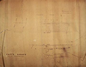
Plan - Tait's Shaft, South Costerfield
... ...Margaret Roberts...Plan forms part of the Margaret Roberts Collection ...Plan forms part of the Margaret Roberts Collection Plan Tait's Shaft, South Costerfield ...Bendigo Advertiser 1873, 11 September, : 'Mr. Tait is now in charge of the South Costerfield'. 'Tait and Hamilton's Half Way House' was a hotel between the McIvor diggings and Rushworth.Longitudinal section of Tait's Shaft, South Costerfield. Plan printed on light tan paper, black text. Plan forms part of the Margaret Roberts Collection bendigo, margaret roberts, gold, tait, south costerfield, tait and hamilton's, half way house, mcivor diggings -
 Bendigo Historical Society Inc.
Plan - North Virginia Mine, 1934
... Margaret Roberts...Cundy, 12/5/34' Plan forms part of the Margaret Roberts Collection of mining records. ...Cundy, 12/5/34' Plan forms part of the Margaret Roberts Collection of mining records. Plan North Virginia Mine ...Written on top of plan: 'North Virginia" and underneath title, 'W.H. Cundy, 12/5/34' Plan forms part of the Margaret Roberts Collection of mining records. margaret roberts, gold, gold mine, bendigo, north virginia mine -
 Bendigo Historical Society Inc.
Plan - New Chum Railway Eureka
... ...Margaret Roberts...Forms part of the Margaret Roberts Collection ...Forms part of the Margaret Roberts Collection Plan New Chum Railway Eureka ...New Chum Railway Mine was located in between Breen Street and the Railway Line in Golden Square. Nearest intersection, Breen and Laurel Streets. Latitude & Longitude (WGS84): 36° 46' 20'' South , 144° 15' 57'' East Latitude & Longitude (decimal): -36.77235,144.26581 Plan on white paper of New Chum Railway Gold Mine, Eureka Gold Mine and South Bellevue lease boundaries. Forms part of the Margaret Roberts Collection bendigo, margaret roberts, gold, new chum railway mine, eureka, breen street, railway line, golden square -
 Bendigo Historical Society Inc.
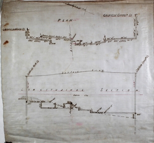
Plan - Goldfields Consolidated Co
... Margaret Roberts...Plan forms part of the Margaret Roberts Collection of mining records. ...Plan forms part of the Margaret Roberts Collection of mining records. Plan Goldfields Consolidated Co. ...Goldfields North and Goldfields Consolidated Co. were located on Diamond Hill, Spring Gully. Plan and longitudinal section of Goldfields North and Goldfields Consolidated Co. Plan drawn on off white paper. Plan forms part of the Margaret Roberts Collection of mining records. margaret roberts, gold, gold mine, goldfields consolidated co., bendigo -
 Bendigo Historical Society Inc.
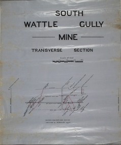
Map - South Wattle Gully Co
... Margaret Roberts...Plan forms part of the Margaret Roberts Collection of mining records. ...Margaret Roberts gold Chewton shaft South Wattle Gully Co gold mine Plan drawn on wax paper. ...Plan drawn on wax paper. Written on top of plan: South Wattle Gully Mine, Transverse Section. Plan forms part of the Margaret Roberts Collection of mining records. margaret roberts, gold, chewton, shaft, south wattle gully co, gold mine -
 Bendigo Historical Society Inc.
Administrative record - Great Columbian Mining Company Minute Book 1898 - 1904, 1898 - 1904
... ...Margaret Roberts...The Minute Book is part of the Margaret Roberts Collection of mining documents....The Minute Book is part of the Margaret Roberts Collection of mining documents. ...Maroon hard cover book, buff binding on spine and corners of cover. Two hundred and seventy pages. Written on first page: ' The Great Columbian Mining Company No Liability'. Minute book forms part of the Margaret Roberts Collection of Mining records. Preliminary meeting of shareholders was held at City Chambers, High Street, Bendigo on 12th September 1898; James Hedley Chairman. The Minute Book is part of the Margaret Roberts Collection of mining documents.bendigo, margaret roberts, , goldmining, mccoll and rankin, city chambers bendigo, the great columbian mining co. -
 Bendigo Historical Society Inc.
Plan - Prince of Wales No. 2 shaft
... Margaret Roberts...Plan forms part of the Margaret Roberts Collection of mining records. ...Plan forms part of the Margaret Roberts Collection of mining records. Plan Prince of Wales No. 2 shaft ...Princ e of Wales No. 2 shaft was located approx.130 metres west of the corner of Williams Road and Hopkins Avenue, Eaglehawk. Drawn on paper, plan shows cross section of mine workings. Written in pencil on top of plan 'Prince of Wales No. 2'. Plan forms part of the Margaret Roberts Collection of mining records. margaret roberts, gold, gold mine, bendigo, prince of wales no. 2 gold mine, williams road, hopkins avenue -
 Bendigo Historical Society Inc.
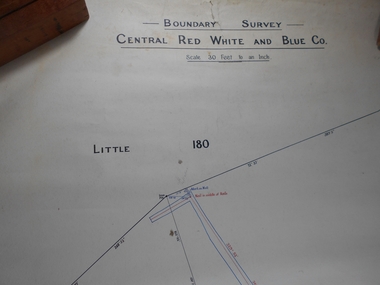
Plan - Central Red, White and Blue Mine
... ...Margaret Roberts Collection...Cundy, Surveyor Forms part of the Margaret Roberts Collection of mining records....Cundy, Surveyor Forms part of the Margaret Roberts Collection of mining records. Plan Central Red, White and Blue Mine ...The Central Red White and Blue Gold Mine was Bendigo's leading gold mine from 1910 - 1913. During the mine's operation, the main shaft was sunk 670 metres, and retrieved over 2500KG of gold. The Central Red White and Blue Gold Mine was located on the corner of Chum St and Honeysuckle St in Golden Square. Extract from Whitelaw Report: Central Red White and Blue Mine, Bendigo. Author: H E Whitelaw Share Abstract Early in 1910, some considerable time after it had become generally known that a rich reef at a depth of 405 ft was being worked southward from the privately owned Lansell's Little 180 shaft and immediately following the plotting of the Geological Survey pitch diagram of the Sheepshead line of reefs, some wide awake local mining men seized the opportunity to secure the holding known as Eadie's which, overlapping Lansell's lease and containing a stretch of the Sheepshead reef channel between the Little 180 north and south shafts, had been declared void some five years previously. That the Lansell Estate did not acquire this property on its becoming available is puzzling in the light of the fact that in Eadie's day the late Mr G W Lansell, on discovering auriferous spurs in the south shaft (now the Central Blue) had offered 2,000 pounds for, and a percentage of gold won from the lease. https://search.informit.org/doi/10.3316/aesis.200105326 Draftsman's drawing of Central Red, White and Blue Mine Map. Printed by Troedel & Cooper Pty Ltd. Mr. H. Cundy, Surveyor Forms part of the Margaret Roberts Collection of mining records.bendigo, gold, map, mine, central red white & blue, margaret roberts collection, sheepshead reef -
 Bendigo Historical Society Inc.
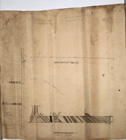
Plan - North Virginia Mine
... Margaret Roberts...Plan forms part of the Margaret Roberts Collection of mining records. ...Plan forms part of the Margaret Roberts Collection of mining records. Plan North Virginia Mine ...Drawn on off-white paper, transverse section of North Virginia Mine, Paddy's Gully line. Scale 40 ft to an inch. Plan forms part of the Margaret Roberts Collection of mining records. margaret roberts, gold, gold mine, north virginia mine -
 Bendigo Historical Society Inc.
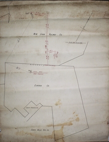
Plan - New Chum and Victoria Lease
... Margaret Roberts...Plan forms part of the Margaret Roberts Collection of mining records. ...Plan forms part of the Margaret Roberts Collection of mining records. Plan New Chum and Victoria Lease ...New Chum Gully is one of the earliest and most important alluvial and quartz mining gully of Bendigo goldfields. It was also one of the more lucrative reefs and became the site of extensive quartz reef mining with some of the richest mines of the field, led by George Lansell and Daniel Barnet Lazarus. These included the nearby mine sites of New Chum and Victoria, New Chum United, Old Chum, Lansells 222 and Lazarus as well as operating extensive battery buildings and pyrites works that were all located in New Chum Gully between Booth, Thistle Streets and Maple Street. (City of Greater Bendigo, Heritage Report, 27 Pallett Street, Golden Square)New Chum and Victoria Lease plan. Written on outside of plan: ' Western Portion, New Chum and Victoria Lease, 2 chains to an inch'. Plan forms part of the Margaret Roberts Collection of mining records. margaret roberts, gold, gold mine, new chum and victoria lease, victoria hill, bendigo