Showing 15 items matching "melbourne arts precinct"
-
 University of Melbourne, Burnley Campus Archives
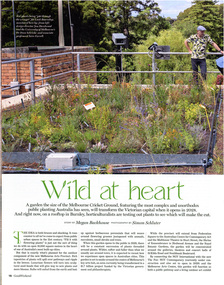
Magazine - Magazine article, The Age, Wild At Heart, 22.02.2025
... ...melbourne arts precinct...Article in the Saturday Age Good Weekend, February 22, 2025 pp16-18 about Laark Boorndap, the outdoor component of the new Melbourne Arts Precinct. The University of Melbourne's role in testing plants on the roof of the Administration Building at Burnley Campus. ...University of Melbourne, Burnley Campus Archives 500 Yarra Boulevard Richmond melbourne saturday age good weekend laark boondap melbourne arts precinct testing plants roof gardens administration building hassell jon hazelwood dean shrieke claire farrell Article in the Saturday Age Good Weekend, February 22, 2025 pp16-18 about Laark Boorndap, the outdoor component of the new Melbourne Arts Precinct. ...saturday age good weekend, laark boondap, melbourne arts precinct, testing plants, roof gardens, administration building, hassell, jon hazelwood, dean shrieke, claire farrell -
 University of Melbourne, Burnley Campus Archives
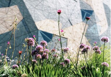
Postcard, The University of Melbourne, Test Garden, 2025
... ...melbourne arts precinct...roof gardens test garden map melbourne arts precinct 2 postcards with an image of the Test Garden at Fed Square, built as part of the Melbourne Artas Prceinct (MAP) Transformation. ...roof gardens, test garden, map, melbourne arts precinct -
 City of Melbourne Libraries
Photograph, Bull, Hugh Jones, 1897-1993, Princes Bridge Centenary pylons under construction
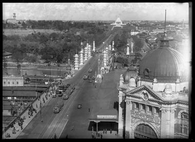
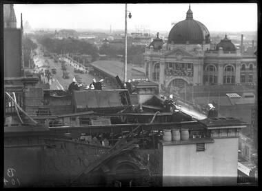
... South of the river and west of the bridge is an area today developed into the Melbourne arts precinct of Hamer Hall and the Arts Centre. ...South of the river and west of the bridge is an area today developed into the Melbourne arts precinct of Hamer Hall and the Arts Centre. ...Princes Bridge Centenary pylons under construction Possibly taken from Young and Jacksons Hotel (formerly Princes Bridge Hotel) on the corner of Flinders and Swanston streets, Flinders Street Station’s clocks and main entrance dominate, along with its distinctive copper dome and decorative façade. The time on the main clock is 1.40pm, and the sign underneath, reflecting Melbourne’s upcoming Centenary reads, “We must accommodate our Centenary visitors! Citizens! Do your share by taking paying guests.” At left is the original Princes Bridge Station, today the site of Federation Square. The riverside tram terminus advertises a Café/Tobacconist/Refreshment Room selling cigars & cigarettes, fountain drinks & confectionery, and in smaller text: “Leave your boot repairs here”. Nearly everyone is dressed in dark suits, coats and hats. The footpaths are wide and there are no traffic lights. The roadway stretches towards the Shrine of Remembrance, not yet dedicated but very dominant on the skyline. Government House is clearly visible across the wide parkland that would come to be known as Kings Domain and that is an area of deep importance to the people of the Eastern Kulin. Originally, Birrarung was part of a network of swamps and lagoons linked to the course of the river. From 1896, Public Works Department engineer Carlo Catani, oversaw a new channel to straighten the river and the swamps and lagoons were filled with spoil from the channel works. From the same vantage point today, only the top of the tower of Government House would be visible. The photo captures the pylons along Princes Bridge, mid-construction and being installed to mark Melbourne’s Centenary. The pylons were not without controversy. Both The Argus and The Age bemoaned them for being “made almost entirely of imported softwood timber”, denying work to native hardwood timber workers and sawmillers, and leading visitors to think Australia did not have its own exceptional native hardwoods. The pylons were also variously described in their incomplete state, as unimaginative and resembling an oilfield. Published: The Age 5 September 1934 Featured in "Newsworthy: Melbourne in photographs 1933-1936" exhibition at East Melbourne Library, October to December 2023. Exhibition caption by project volunteer, Louise McKenzie Photographer notations on slide: "Pylons + St Kilda Rd C57" Published: Age (Melbourne, Vic. : 1854 - 1954), Wednesday 5 September 1934, page 11 Published title: DECORATIONS -- THEN AND NOW. Published caption: "Although not completed yet, some impression of the effect of the decorations on Princes-bridge may be obtained from the first picture which shows the majestic sweep of St Kilda road with the Shrine of Remembrance and Government House dominating the horizon. The area to the left of St. Kilda-road and in front of Government House is portion of the area which it is proposed to call the King's Domain, which extends to Domain-road and Anderson-street..." Description: East-facing, elevated view of Flinders Street Station and Princes Bridge, featuring partially completed pylons erected for Melbourne's Centenary celebrations. The Shrine of Remembrance and Government House can be seen in the distance. In the foreground are trams, cars and trucks, pedestrians, Batman Avenue tram terminus and refreshment rooms. Signage on Flinders Street Station encourages citizens to accommodate Centenary visitors. The Melbourne Centenary was held 1934-35 in celebration John Batman's proclamation that Melbourne "the place for a village". Centenary events included a visit by Prince Henry, Duke of Gloucester. A Centenary Cake measuring 50 feet in height and ten tons in weight was cut into 250,000 pieces and sold at 1 shilling per piece for charity. Spectacular floodlighting of city landmarks, the creation of the Pioneer Women's Memorial Garden, and the MacRobertson Air Race from London, were other notable activities. Research by project volunteer, Louise McKenzie: The photo in The Age collage of 5 September 1934 has a slightly cropped foreground. The original photo has been taken from an elevated vantage point, most probably the roof of the Nicholas Building on the corner of Flinders and Swanston streets. The right foreground is dominated by the main “clocks” entrance to Flinders Street Station, showing its distinctive copper dome and decorative façade. The time on the main clock is 1.40 pm. The main sign on the front of the Station reads, "We Must Accommodate our Centenary Visitors! Citizens! Do your share by taking paying guests. Write to The Official Centenary Accommodation Bureau, 436 Collins St. City. Tel M 4671”. Another sign at eye level at the main entrance says: “Cheap Trips on Sundays”. The sign on the end of the roof along the eastern side of the station reads, “The Babies Need Your Help! Support Broadmeadows Foundling Hospital Appeal. July and August”. Run by the Sisters of St Joseph of the Sacred Heart, St Joseph’s Foundling Hospital was a purpose built infants’ home for up to 300 babies, plus accommodation for expectant mothers, mainly single women. In the early 1930s, the department (Victorian Children’s Welfare Department) contracted St Joseph’s Foundling Hospital to care for an additional 60 infant state wards, and up to 175 non wards at any given time. In 1931 it also operated a mothercraft training school. The centre foreground shows the commencement of Princes Bridge. Beneath the left side of the bridge was the site of the original Princes Bridge Station, by this time incorporated into Flinders Street Station, and today the area is the site of Federation Square. It was linked to Flinders Street station by the railway tracks that ran underneath the northern approach to the bridge. This photo shows a tram terminus which has a Café/Tobacconist/Refreshment Room, selling cigars & cigarettes, fountain drinks & confectionary, and a sign: Leave your boot repairs here. In the foreground is a wide roadway running south/north, comprising two vehicle lanes each heading north/south, and a central section containing two sets of tram tracks. There are cars, buses and delivery vans on the roadway. The trams visible are Glen Iris (Route No. 6; tram no. 448), Toorak (Route No. 8, tram no. 333), ? (No. 7), ? (No. 1), and ? (No. 2A). The footpaths are extremely wide. There is a square newspaper/magazine stand on the eastern side footpath. And also a “Ferry” sign. There are no traffic lights, but a policeman is visible on the roadway. There are pedestrians – men, women, children, a porter with trolley, women with prams. Clothing comprises dark suits, coats and hats for nearly everyone. There are double headed “Collins Street” lights along the side of the roadway, and along the northern riverbank. The roadway in the foreground is an extension of Swanston Street, which becomes Princes Bridge, then St Kilda Road, stretching towards the Shrine of Remembrance, and diverting past it. The Shrine had not yet been officially dedicated, and looks very white and dominant on the skyline. On the LHS of St Kilda Road, Government House is clearly visible across the wide parkland to be known as Kings Domain. The Kings Domain area is important to the people of the Eastern Kulin nation, and also has historical importance for its association with the early settlement of Melbourne and the foundation of British colonial administration in Victoria. On the southern side of the Yarra River (Birrarung) an historic rowing boathouse is visible, located adjacent to the Alexandra Gardens. Originally Birrarung was part of a network of swamps and lagoons linked to the course of the river. From 1896, under the guidance of engineer Carlo Catani* a new channel to straighten the river was created and the swamps and lagoons were filled with spoil from the channel works. The gardens were then created and completed in time for a Royal visit by the Duke of York in May 1901. The gardens are named after Alexandra of Denmark, the wife of King Edward VII. Both these areas, plus the Royal Botanic Gardens Victoria, Shrine of Remembrance Reserve, Sidney Myer Music Bowl, Government House, and the Queen Victoria Gardens together form the Domain Parklands. The extent of the subsequent plantings is evident today, where from the same vantage point only the top of the tower of Government House would be visible. *Catani was born in Florence in 1852, but after arriving in Melbourne worked as a civil engineer for the Victorian Government. His last major project was the reclamation of the foreshore of St Kilda, envisaged in the style of a European resort, complete with a split level esplanade, bathing pavilions, dance halls, amusements and a French-Italian style of landscape complete with palms. The gardens at the end of Fitzroy Street, St Kilda, now bear his name. The historic boathouse visible across the Yarra is another glimpse into Melbourne’s past. “Boathouse Row” comprises 7 amateur rowing clubs, the first established in 1859 (Melbourne University Boat Club). Other Clubs were Richmond, Melbourne, Banks, Melbourne Grammar School, Yarra Yarra and Mercantile. South of the river and west of the bridge is an area today developed into the Melbourne arts precinct of Hamer Hall and the Arts Centre. But at this time it was the home of Wirths Olympia Circus, which comprised Wirths Pleasure Park (an amusement park), a 5,000 seat auditorium – Hippodrome, a roller skating rink, a glaciarium, a cinema, and the Green Mill Dance Hall. Dog shows were also held at Olympia. The Green Mill Dance Hall closed in 1950, and the remainder of the Wirth buildings on site were destroyed by fire in December 1953. The feature of the photo is the pylons erected along Princes Bridge to mark Melbourne’s Centenary in 1934. The sixteen plastered pylons were designed by Roy Prentice, the second person to qualify as an architect at The University of Melbourne’s Bachelor of Architecture degree, in 1933, aged 27. Simon Reeves in his article marking the 100th birthday of Roy Prentice on 20 June 2006 reports that the State Electricity Commission sponsored this work, and the Argus reported that “… the pylons were “illuminated from within to give the effect of soft radiance”. Australia Home Beautiful 1 Oct 1934 reports in a very detailed and comprehensive article: The 10 taller pylons, including flagpole, were 48 ft, with a base of 8 ft. Timber-framed and faced with fibrous plaster and galvanised sheet iron, each structure was securely bolted to a concrete foundation three feet in depth. Panels of glass let into the shaft of each pylon were indirectly lit by 40, 100 watt lamps, and the upper bank of internal lamps were dyed so as to flood the panels with a deep red light. The decorative painted shields and flagpoles/pennants were illuminated by three 200 watt projectors concealed in the roof of each pylon, and were part of an electric night light decoration scheme involving 28 miles of wire to supply more than 20,000 lights. An article in the Argus on 18 October 1934 provided minute detail of the lighting erected in Melbourne for the Centenary, converting it “… into a coloured fairyland by night.” The estimated cost of 10 pounds per hour the lights were on. The display included 800 standard light poles 30 feet high which were tiered with electric bulbs concealed in inverted cones, 138 specially designed “Venetian poles” draped in flags trophies and streamers. The streets included in the electric night light decoration scheme were Bourke Street from Spring to William, the entire length of Collins Street, Flinders Street from Elizabeth to Spring, Lonsdale Street from Elizabeth to Swanston, Swanston and Elizabeth Streets from Flinders to Lonsdale, and parts of Springs and Spencer Streets. Together with the Princes Bridge pylons, approximately 28 miles of wire was required to supply power to the more than 20,000 lights. And that is just in the city of Melbourne. It was estimated the same amount of lighting was duplicated among other local councils. The pylons were not without controversy. The Argus on 28 August 1934 in an article headed “Imported Timber in Pylons” reported that the Princes Bridge pylons are “made almost entirely of imported softwood timber”, and have therefore denied work to native hardwood timber workers and sawmillers. The same day the Melbourne Age ran a similar story, bemoaning the fact that foreign oregon had been used which may lead tourists to think Australia did not have its own exceptional native hardwoods. A Camberwell City Councillor described the pylons as unimaginative, and the Herald reported that skeletons of pylons for the Centenary decorations in their present form led the area to resemble an oilfield! The Yarra River and Princes Bridge have long been a focal point of Melbourne life. In the early days of European settlement in Melbourne a rope-hauled punt carried people across the Yarra River. A surge in population and increased shipping traffic created a need for a bridge. There was difficulty in agreeing on a suitable site for the bridge (options were crossing at Elizabeth, Swanston, Queen or Market Streets), but the NSW Government favoured Swanston Street and the Melbourne Town Council decided on a temporary bridge across the Yarra spanning from the foot of Swanston Street. This first bridge was a single span timber toll bridge designed by Scottish born bridge designer David Lennox, and completed in 1845. It was 120 feet long, had a roadway of 17 feet wide, and a footpath on one side of 4 feet. It was leased to the Melbourne Bridge Company in the name of Robert A Balbirnie. The tollhouse was on the north side of the river and the toll keeper, Patrick Doherty, was credited with saving nine lives during the four years he was in charge of the toll station. The second bridge was stone (completed 1850), and named Prince’s Bridge after the HRH Prince of Wales, later Edward VII. It was designed with an elliptical single arc and an exceedingly small rise in proportion to the span. However, this design created an obstacle for flood waters, and together with Melbourne’s increasing population it was quickly apparent that a new bridge was required. At its opening on 15 November 1850 coincided with the imminent declaration of Victoria as a separate colony, it provided a moment of great celebration for Melbournians and “The opening ceremony was described as the grandest processional display witnessed in the colony.” (ToMelbourne.com.au) Princes Bridge in its present form, as depicted in this photograph, was designed by Jenkins, D’Ebro and Grainger, and constructed in 1886-88 by David Munro. John Grainger (father of Australian composer Percy Grainger) did the majority of the design work for the bridge. The structure was to have three arches each 96 feet wide measured across the river, and the banks on both sides were raised to allow more space for floodwater to flow. St Kilda Road was originally many feet below the current level. The bridge is of architectural significance for its substantial size, giant half columns, extensive use of wrought and cast iron, decorative elements (cast-iron lamps) and the skilled stonemasonry in the construction of the abutments and piers. Its main design features are similar to those of Blackfriars Bridge in London (1870). The bluestones were quarried from Footscray, the Malmsbury stones were from quarries at Kyneton, and the granite from Harcourt. The cost was met by the State of Victoria, City of Melbourne, and six out of seven of its municipalities, and their coats of arms feature on the bridge. The building of the bridge reflected the boom period of Melbourne, including the Victorian gold rush 1851- late 1860s, and its contractor, David Munro, was also responsible for the construction of Queens Bridge and Sandridge Railway Bridge. The Centenary pylons are no longer in place, but today this intersection still plays a major part in Melbourne’s daily life: people still meet “under the clocks” at Flinders Street station, and the route in and out of the city along St Kilda Road is often a feature of parades such as Moomba, the Grand Final Parade, and of course the Anzac Day Parade which commences at the Princes Bridge intersection and finishes at the Shrine of Remembrance. There are many tram routes, which cross the Bridge, and it directs pedestrians towards the Arts Precinct, the various components of Domain Park, plus the Southbank restaurant and rowing precincts. Even though this is a street scene, it feels very intimate; the viewer is instantly immersed in the activity of a Melbourne afternoon, looking down St Kilda Road from a viewpoint near today’s Federation Square. References: DECORATIONS -- THEN AND NOW. (1934, September 5). The Age (Melbourne, Vic. : 1854 - 1954), p. 11. Retrieved September 21, 2023, from http://nla.gov.au/nla.news-article205880269 'Flinders Street railway station', Wikipedia, https://en.wikipedia.org/wiki/Flinders_Street_railway_station 'St Joseph’s Foundling Hospital (1901-75)', Finding Records, Department of Health and Human Services, State of Victoria, https://www.findingrecords.dhhs.vic.gov.au/collectionresultspage/St-JosephsFoundling-Hospital-Babies-Home#departmental-administration 'Alexandra Gardens', City of Melbourne, https://www.melbourne.vic.gov.au/community/parks-open-spaces/major-parks-gardens/Pages/alexandra-gardens.aspx 'Wirths Circus', Wikipedia, https://en.wikipedia.org/wiki/Wirth's_Circus 'Roy Prentice: Centenary Architect', Built Heritage Pty Ltd, Simon Reeves, https://www.builtheritage.com.au/downloads/prentice.pdf 'Princes Bridge', Heritage Council Victoria, https://vhd.heritagecouncil.vic.gov.au/places/817 PORT PHILLIP. (1846, April 1). The Sydney Morning Herald (NSW : 1842 - 1954), p. 3. Retrieved September 21, 2023, from http://nla.gov.au/nla.news-article12886251 'Edward VII', Wikipedia, https://en.wikipedia.org/wiki/Edward_VII 'Princes Bridge', ToMelbourne.com, https://tomelbourne.com.au/princes-bridge/ 'Princes Bridge', eMelbourne, https://www.emelbourne.net.au/biogs/EM01189b.htm 'Princes Bridge', Australia for everyone, http://australiaforeveryone.com.au/files/melbourne/princes-bridge.html 'Victorian gold rush', Wikipedia, https://en.wikipedia.org/wiki/Victorian_gold_rush IMPORTED TIMBER IN PYLONS (1934, August 28). The Argus (Melbourne, Vic. : 1848 - 1957), p. 9. Retrieved September 21, 2023, from http://nla.gov.au/nla.news-article10952507 Princes-Bridge Pylons. (1934, August 28). The Age (Melbourne, Vic. : 1854 - 1954), p. 7. Retrieved September 21, 2023, from http://nla.gov.au/nla.news-article205532235 Pylons Appear Near Princes Bridge (1934, August 18). The Herald (Melbourne, Vic. : 1861 - 1954), p. 1. Retrieved September 21, 2023, from http://nla.gov.au/nla.news-article243104375 PRINCES-BRIDGE PYLONS. (1934, September 20). The Age (Melbourne, Vic. : 1854 - 1954), p. 10. Retrieved September 21, 2023, from http://nla.gov.au/nla.news-article205873535 28 Miles of Wire (1934, October 18). The Argus (Melbourne, Vic. : 1848 - 1957), p. 1 (The Junior Argus). Retrieved September 21, 2023, from http://nla.gov.au/nla.news-article10977836 'Historical references for Boathouse Row, Melbourne', http://boathouserowmelbourne.com.au/history/ 'ITALIAN DELEGATION TO HONOUR CARLO CATANI, DESIGNER OF THE ST KILDA FORESHORE, St Kilda Historical Society, 2001, https://web.archive.org/web/20070928061938/http://www.skhs.org.au/~SKHSarticles/articles/Carlo_Catani.html# HISTORY IN LIGHTS (1934, July 12). The Herald (Melbourne, Vic. : 1861 - 1954), p. 16. Retrieved September 21, 2023, from http://nla.gov.au/nla.news-article243172436 'Dressing Melbourne for the Duke', The Australian home beautiful: a journal for the home builder. Vol 12 No. 10 (1 October 1934), page 21, 58. Retrieved September 14, 2023, from http://nla.gov.au/nla.obj-2950922209Photographer notations on slide: "Pylons + St Kilda Rd C57".centenaries, bridges, lighting, flinders street railway station -
 Glen Eira Historical Society
Ephemera - SHELFORD GIRLS’ SCHOOL AND KINDERGARTEN
... This file contains 7 items relating to advertising for the school and its events: 1/1 2 page advertisement for Shelford, dated February 2010, from an unknown publication. 2/1 1 page advertisement for Shelford Scholarships from ‘DUX 2010’, South Edition, published by Leader News. 3/1 advertisement for Shelford tours and the opening of the Performing Arts Precinct 03/04/2011, published in the ‘Melbourne Weekly Bayside’ 23/03/2011. 4/1 advertisement for Shelford tours and the opening of the Performing Arts Precinct 03/04/2011 published in the ‘Caulfield/Port Phillip Leader’ 29/03/2011. 5/1 advertisement advertising Shelford school and its upcoming events, published in the ‘Melbourne Weekly Bayside’, 11/05/2011. 6/1 advertisement advertising Shelford school and its upcoming events, published in the ‘Caulfield/Port Phillip Leader’, 17/05/2011 7/1 advertisement for Shelford school from ‘DUX 2011’, South Edition, published by Leader News....Glen Eira Historical Society 965 Glen Huntly Rd Caulfield VIC 3162 melbourne This file contains 7 items relating to advertising for the school and its events: 1/1 2 page advertisement for Shelford, dated February 2010, from an unknown publication. 2/1 1 page advertisement for Shelford Scholarships from ‘DUX 2010’, South Edition, published by Leader News. 3/1 advertisement for Shelford tours and the opening of the Performing Arts Precinct 03/04/2011, published in the ‘Melbourne Weekly Bayside’ 23/03/2011. 4/1 advertisement for Shelford tours and the opening of the Performing Arts Precinct 03/04/2011 published in the ‘Caulfield/Port Phillip Leader’ 29/03/2011. 5/1 advertisement advertising Shelford school and its upcoming events, published in the ‘Melbourne Weekly Bayside’, 11/05/2011. 6/1 advertisement advertising Shelford school and its upcoming events, published in the ‘Caulfield/Port Phillip Leader’, 17/05/2011 7/1 advertisement for Shelford school from ‘DUX 2011’, South Edition, published by Leader News. education schools Shelford music sport Shelford Girls’ School and Kindergarten art Anglican Church Hood Crescent Caulfield Ciolli Judy theatres Dillon Paul Walker Kathy drama tertiary education secondary education secondary schools primary education preschool education advertisements advertising Ephemera SHELFORD GIRLS’ SCHOOL AND KINDERGARTEN ...This file contains 7 items relating to advertising for the school and its events: 1/1 2 page advertisement for Shelford, dated February 2010, from an unknown publication. 2/1 1 page advertisement for Shelford Scholarships from ‘DUX 2010’, South Edition, published by Leader News. 3/1 advertisement for Shelford tours and the opening of the Performing Arts Precinct 03/04/2011, published in the ‘Melbourne Weekly Bayside’ 23/03/2011. 4/1 advertisement for Shelford tours and the opening of the Performing Arts Precinct 03/04/2011 published in the ‘Caulfield/Port Phillip Leader’ 29/03/2011. 5/1 advertisement advertising Shelford school and its upcoming events, published in the ‘Melbourne Weekly Bayside’, 11/05/2011. 6/1 advertisement advertising Shelford school and its upcoming events, published in the ‘Caulfield/Port Phillip Leader’, 17/05/2011 7/1 advertisement for Shelford school from ‘DUX 2011’, South Edition, published by Leader News.education, schools, shelford, music, sport, shelford girls’ school and kindergarten, art, anglican church, hood crescent, caulfield, ciolli judy, theatres, dillon paul, walker kathy, drama, tertiary education, secondary education, secondary schools, primary education, preschool education, advertisements, advertising -
 Greensborough Historical Society
Newspaper - Newspaper Clipping, The Whittlesea Post, Bundoora Homestead to become arts precinct, 1997_
... Greensborough Historical Society 34A Glenauburn Road Lower Plenty Lower Plenty melbourne A collection of articles about Bundoora Homestead and Mount Cooper. bundoora homestead mount cooper Collection of newspaper articles; text and black and white images. Bundoora Homestead to become arts precinct ...A collection of articles about Bundoora Homestead and Mount Cooper.Collection of newspaper articles; text and black and white images.bundoora homestead, mount cooper -
 Eltham District Historical Society Inc
Photograph, Fred Mitchell, Arts Precinct, St Kilda Road, Southbank, 1996, 1996
... Eltham District Historical Society Inc 728 Main Rd Eltham melbourne fred mitchell collection 1996 Arts Precinct Southbank St Kilda Road Digital copy of colour photograph Arts Precinct, St Kilda Road, Southbank, 1996 Photograph Fred Mitchell ...Digital copy of colour photographfred mitchell collection, 1996, arts precinct, southbank, st kilda road -
 Sunshine and District Historical Society Incorporated
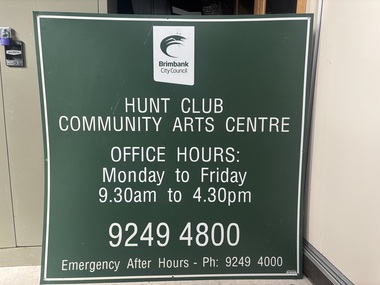
Sign - Hunt Club Community Arts Centre Sign
... Arts Centre, 775 Ballarat Road, Deer Park 3023. Brimbank Library, 301 Hampshire Road, Sunshine 3020. melbourne The two storey The Hunt Club Hotel was built in 1886, replacing a much earlier single storey hotel from the 1850's, that burnt down the same year. In 1982, the City of Sunshine purchased the historic Hunt Club Hotel and surrounding land from ICI. The building was then repurposed by the Brimbank City Council and opened in 1985 as a community arts precinct ...The two storey The Hunt Club Hotel was built in 1886, replacing a much earlier single storey hotel from the 1850's, that burnt down the same year. In 1982, the City of Sunshine purchased the historic Hunt Club Hotel and surrounding land from ICI. The building was then repurposed by the Brimbank City Council and opened in 1985 as a community arts precinct offering art classes, exhibitions, artist studios, community arts projects, a garden amphitheatre for performances and rooms for hire for community and business groups.The Hunt Club Community Arts Centre is located in one of the few surviving 19th‑century buildings in Deer Park and surrounding district.Metal sign painted green with white writing.Brimbank City Council Hunt Club Community Arts Centre Office Hours Monday to Friday 9:30am to 4:30pm 92494800 Emergency After Hours Ph 9249 400the hunt club and community arts centre, ballarat road, deer park -
 Sunshine and District Historical Society Incorporated
Photograph - Deer Park ICI Employee's Houses Photograph
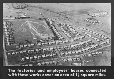
... Arts Centre, 775 Ballarat Road, Deer Park 3023. Brimbank Library, 301 Hampshire Road, Sunshine 3020. melbourne The Deer Park ICI Employees Housing Estate was built in stages from the 1920s to the 1950s to house workers and managers of the Nobel/ICI explosives and chemical works. It is now recognised as a State‑significant company town precinct ...The Deer Park ICI Employees Housing Estate was built in stages from the 1920s to the 1950s to house workers and managers of the Nobel/ICI explosives and chemical works. It is now recognised as a State‑significant company town precinct for its rare surviving examples of employer‑built housing in Victoria. When Nobel merged into ICIANZ (Imperial Chemical Industries of Australia and New Zealand) in 1928, the company expanded the housing program. Sassella Park, centre left was sold to the Shire of Braybrook by Mr. Antonio Sassella in 1925. In December 1929, Sassella Park officially opened as a sports ground, thus Sassella Park predating the ICI housing estate expansion, the post‑war suburban development and the 1950s–60s civic infrastructure boom throughout Deer Park.This photograph captures one of the few purpose‑built industrial housing estates in Victoria. ICI deliberately built a company‑town layout with , Recreation Reserve, Deer Park Hall, the Hunt Club Hotel was used as an ICI training Centre, Social Club and Community Facilities.The factories and Employee's houses connected with these works cover an area of 1 1/2 square milesdumfries street, station road, kynoch street, welwyn parade, downes way, irvine street, slough street, milbank drive, huddersfield road, sassella park, sassella park caretakers house, ici, kororoit creek, deer park -
 City of Melbourne Libraries
Photograph, Bull, Hugh Jones, 1897-1993, Fire at Cathedral Hotel, Swanston Street, Melbourne
... Melbourne Arts Centre. Adjacent to the station is a large covered area, still extant today as part of the Station precinct. ...Melbourne Arts Centre. Adjacent to the station is a large covered area, still extant today as part of the Station precinct. ...Fire at the Cathedral Hotel! Southward view Firemen in their shiny brass Merryweather style helmets battle a fire in the roof of the Cathedral Hotel, Tuesday 3 March 1936. It was located on the corner of Swanston Street and Flinders Lane and so named for its proximity to St Paul’s Cathedral, just visible at top left. The fire broke out in between the roof space and wooden ceiling of the hotel at around 4.30 pm, causing disruption to afternoon commuters – hence the banked-up trams along St Kilda Road. The hoses snaking across the roof have been dragged up through the hotel’s front door. The scene of devastation on the roof appears to be a result of both the fire and firefighting efforts. The panoramic background is dominated by the dome of Flinders Street Station, the wide, treed boulevard of St Kilda Road, and a densely built-up industrial area south of the Yarra with its elevated signage and substantial buildings. Featured in "Newsworthy: Melbourne in photographs 1933-1936" exhibition at East Melbourne Library, October to December 2023. Exhibition caption by project volunteer, Louise McKenzie. Photographer notations on slide: "Fire at Cathedral Hotel Swanston St 1936 B104" Description: This photo, taken from an adjacent building, shows 12 firemen fighting a fire on the roof of the Cathedral Hotel, Melbourne. There is evidence of considerable damage to the roof of the building as a result of the fire and fire fighting efforts. The photo gives a feeling of elevation, as the firemen are in focus, with an out of focus panoramic background, showing the dome of Flinders Street Station, and St Kilda Road down to the Shrine. Research by project volunteer, Louise McKenzie: The Age reported on 4 March 1936 that the fire broke out in rubbish between the roof space and wooden ceiling of the Cathedral Hotel at 4.30 pm. “The Eastern Hill fire brigade was notified by telephone, and an almost simultaneous call was also received at fire brigade headquarters from a street alarm.” The firemen in their dark uniforms with brass buttons, gold epaulettes and shiny brass Merryweather helmets, stand out against the broken slate tiles and dislodged timber of the damaged roofing, all of which look blackened and in disarray. Two pale water hoses snake thickly across the roof. It is a scene of some devastation and chaos. Three chimney pots by contrast sit plump and strong against the damage. The Cathedral Hotel is located on the corner of Swanston Street and Flinders Lane, so named due to its proximity to St Pauls Cathedral (just visible at far left) on the corner of Flinders and Swanston streets. This intersection is a hub and focus of Melbourne activity. The backgrounded Melbourne skyline, while not in clear focus, is of interest. On the right is the impressive dome of Flinders Street Station, with the clock at 4.50 pm. Its grand frontage, and some of the façade along Flinders Street, are visible. To the left is the wide and grand-scaled St Kilda Road, leading down to the Shrine of Remembrance. There are many trams on Princes Bridge (mostly heading northward), together with some trucks and pedestrians. The pedestrian walkway along Princes Bridge is wide, and the Bridge balustrade lined with flag poles. The middle background shows a large number of trees. This was the site of Wirths Brothers Circus, an impressive complex including an octagonal circus Hippodrome (5000 seat auditorium), Pleasure Park, roller skating rink, and Dance Hall. Today it is the site of the Melbourne Arts Centre. Adjacent to the station is a large covered area, still extant today as part of the Station precinct. Floating above the horizon is sign advertising 'DUNLOP', located in the formerly industrial area which is today’s Southbank. Port Phillip Bay is faintly visible in the distance. The city seems sprawling, but uncrowded, and well punctuated by trees. Two photos were included an Age pictorial, one showing the firefighters at work, the other a crowd scene at street level (see References). These images are not part of the McKenzie Collection. References: No title (1936, March 4). The Age (Melbourne, Vic. : 1854 - 1954), p. 13. Retrieved February 5, 2024, from http://nla.gov.au/nla.news-article205256255 FIRE AT A CITY HOTEL. (1936, March 4). The Age (Melbourne, Vic. : 1854 - 1954), p. 12. Retrieved February 5, 2024, from http://nla.gov.au/nla.news-article205256231 FIRE IN ROOF OF CITY HOTEL (1936, March 4). The Argus (Melbourne, Vic. : 1848 - 1957), p. 8. Retrieved February 5, 2024, from http://nla.gov.au/nla.news-article11018696 Hotel Roof Fire Draws Crowd (1936, March 4). Examiner (Launceston, Tas. : 1900 - 1954), p. 8 (DAILY). Retrieved February 5, 2024, from http://nla.gov.au/nla.news-article52000751 'Flinders Lane Melbourne 1966', Peter Andrew Barrett, Facebook, 12 June 2020, https://www.facebook.com/120943481324886/photos/a.512123662206864/3025002490918956/?type=3Photographer notations on slide: "Fire at Cathedral Hotel Swanston St 1936 B104".fires, 1930-1939, hotels -
 Sunshine and District Historical Society Incorporated
Photograph - Punthill Apartment Hotel Sunshine Opening Photographs, John Alchin, 2024
... Arts Centre, 775 Ballarat Road, Deer Park 3023. Brimbank Library, 301 Hampshire Road, Sunshine 3020. melbourne The new Punthill Apartments Hotel Derby Road Sunshine was built on the former Sunshine Potteries site The complex was officially opened on the 11th November 2024, marking a major addition to the Veriu Group’s expanding apartment‑hotel portfolio. The hotel consists of 90 apartments consisting of studio, 1-bed, 2-bed or 3-bedroom rooms. It is located adjacent to Sunshine Station, positioned to benefit from the Sunshine Precinct ...The new Punthill Apartments Hotel Derby Road Sunshine was built on the former Sunshine Potteries site The complex was officially opened on the 11th November 2024, marking a major addition to the Veriu Group’s expanding apartment‑hotel portfolio. The hotel consists of 90 apartments consisting of studio, 1-bed, 2-bed or 3-bedroom rooms. It is located adjacent to Sunshine Station, positioned to benefit from the Sunshine Precinct Masterplan and future Melbourne Airport Rail link. The Labour State Member for Laverton, Sarah Connolly, cut the ribbon at the opening. Local food businesses provided the food, ARGO Farm Machinery provided a Massey Ferguson tractor display, and the Sunshine & District Historical Society provided a small of display of objects and photographs of interest.This photograph collection documents the opening of the Punthill Apartments Hotel in Derby Road Sunshine.5625.01 - Punthill Apartment Hotel Sunshine Opening 2024 Photo 01.JPG 5625.02 - Punthill Apartment Hotel Sunshine Opening 2024 Photo 02.JPG 5625.03 - Punthill Apartment Hotel Sunshine Opening 2024 Photo 03.JPG 5625.04 - Punthill Apartment Hotel Sunshine Opening 2024 Photo 04.JPG 5625.05 - Punthill Apartment Hotel Sunshine Opening 2024 Photo 16.JPG 5625.06 - Punthill Apartment Hotel Sunshine Opening 2024 Photo 22.JPG 5625.07 - Punthill Apartment Hotel Sunshine Opening 2024 Photo 23.JPG 5625.08 - Punthill Apartment Hotel Sunshine Opening 2024 Photo 24.JPG 5625.09 - Punthill Apartment Hotel Sunshine Opening 2024 Photo 25.JPG 5625.10 - Punthill Apartment Hotel Sunshine Opening 2024 Photo 12.JPG 5625.11 - Punthill Apartment Hotel Sunshine Opening 2024 Photo 17.JPG 5625.12 - Punthill Apartment Hotel Sunshine Opening 2024 Photo 21.JPG 5625.13 - Punthill Apartment Hotel Sunshine Opening 2024 Photo 18.JPG 5625.14 - Punthill Apartment Hotel Sunshine Opening 2024 Photo 09.JPG 5625.15 - Punthill Apartment Hotel Sunshine Opening 2024 Photo 05.JPG 5625.16 - Punthill Apartment Hotel Sunshine Opening 2024 Photo 19.JPG 5625.17 - Punthill Apartment Hotel Sunshine Opening 2024 Photo 20.JPG 5625.18 - Punthill Apartment Hotel Sunshine Opening 2024 Photo 14.JPG 5625.19 - Punthill Apartment Hotel Sunshine Opening 2024 Photo 15.JPG 5625.20 - Punthill Apartment Hotel Sunshine Opening 2024 Photo 13.JPG derby road, sunshine, punthill apartment hotel, hotel -
 Sunshine and District Historical Society Incorporated
Photograph - Matthews Hill Farmhouse Photograph
... Arts Centre, 775 Ballarat Road, Deer Park 3023. Brimbank Library, 301 Hampshire Road, Sunshine 3020. melbourne The Matthews Hill area forms part of the Grand Junction Estate and Matthews Hill Precinct, one of Sunshine’s earliest residential subdivisions ...The Matthews Hill area forms part of the Grand Junction Estate and Matthews Hill Precinct, one of Sunshine’s earliest residential subdivisions. - The Grand Junction Estate was first subdivided in 1886. - The southern half of what is now Matthews Hill was subdivided between 1911 and 1925. - This makes the precinct one of Sunshine’s earliest planned residential neighbourhoods, predating much of the interwar suburban expansion. The precinct stretches between Dickson Street and Matthews Street, bounded by Kingaroy Road, McKay Street, Servante Street, and the railway line. This is the original Matthew's Hill farmhouse. It was located on the North East corner of Derby Road (Now Mattrews Street) and Cornwall Road Sunshine.This is one of a few photographs of the original farmhouses in Sunshine. The local area is known as Matthews Hill, named after the original farm owner.5626 - Matthews Hill Farmhouse Photo 01.JPEGmatthews hill, sunshine, matthews street -
 Melbourne Tram Museum
Magazine, Yarra Trams, "Tramlines - issues 13 August 2008", Aug. 2008
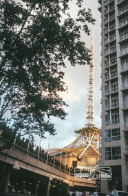
... melbourne Trams tramways C2 class Environment Platform stops Route 86 TramTracker Tickets Events Magazine or newsletter, A3 gloss paper full colour folded to A4 - titled "Tramlines - issues 13 August 2008" published by Yarra Trams. Front cover has a photo of C2, bumblebee 5113 turning into Bourke St from Spring St with the bumblebee symbol on the sheet as well. Other stories are report from CEO Dennis Cliche, wind powered trams, environmental news, laying of new track for the platform stops at the Arts Precinct ...Magazine or newsletter, A3 gloss paper full colour folded to A4 - titled "Tramlines - issues 13 August 2008" published by Yarra Trams. Front cover has a photo of C2, bumblebee 5113 turning into Bourke St from Spring St with the bumblebee symbol on the sheet as well. Other stories are report from CEO Dennis Cliche, wind powered trams, environmental news, laying of new track for the platform stops at the Arts Precinct St. Kilda Road, Route 86, TramTracker, tickets and the International Film Festival.trams, tramways, c2 class, environment, platform stops, route 86, tramtracker, tickets, events -
 Bendigo Historical Society Inc.
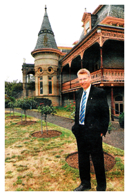
Newspaper - Fortuna Articles - "Great Bravery is now required for villa", Dec 05 2008
... The Villa Fortuna Action Group is the only organization with a public proposal for the site, aiming to create an arts and cultural precinct similar to Melbourne's Abbotsford Convent.The group plans to present its vision to newly elected councillors. ...The Villa Fortuna Action Group is the only organization with a public proposal for the site, aiming to create an arts and cultural precinct similar to Melbourne's Abbotsford Convent.The group plans to present its vision to newly elected councillors. ...Villa Fortuna is described as having unprecedented local historical importance and whimsical architecture, making it a cultural asset for Bendigo. Saving the villa requires a bold and visionary individual or group willing to take on the challenges of restoration, including significant financial and logistical commitments. If restored, the villa could become a major attraction, hosting events, tours, and community activities that would benefit the local economy and tourism sector. The main obstacle is not whether the villa should be saved, but what sacrifices—financial and otherwise—are necessary to achieve this goal. The Villa Fortuna Action Group has developed a plan for the site, but more stakeholders may become involved. The Department of Defence, current owner, is proceeding cautiously with no urgency to sell. The upcoming public opening is seen as a potential turning point, with the document stressing that Bendigo cannot afford to lose this historic property, regardless of the cost. Mayor Kevin Gibbins opposes transforming Fortuna Villa into an arts and cultural precinct, as proposed by the Villa Fortuna Action Group. He believes the property should address local needs such as aged care, dementia, disabilities, and respite for carers. Gibbins emphasizes these are his personal views, not official council policy. Gibbins is concerned about the council's ability to finance the maintenance of the large property, even if acquired at no cost. He questions the justification for using ratepayers' money for new arts projects when there is already a masterplan for the existing art gallery that requires significant funding and staged development. The Villa Fortuna Action Group is the only organization with a public proposal for the site, aiming to create an arts and cultural precinct similar to Melbourne's Abbotsford Convent.The group plans to present its vision to newly elected councillors. The Department of Defence is preparing Fortuna Villa in Bendigo for sale, likely early next year. A tentative timeline suggests most site assessments will be drafted by Christmas, with finalization expected in the new year. Thorough assessments are underway to understand the site's characteristics, including heritage and environmental aspects.These assessments are detailed and time-consuming to ensure accuracy and completeness. An open day for the public and media is part of the ongoing community consultation process. Additional consultation activities are planned but not yet finalized. The City of Greater Bendigo is a key stakeholder in the disposal process and will receive relevant site information.The property has not yet been valued.Fortuna Article - "Great Bravery is now required for villa" - The Bendigo Advertiser Friday Dec 05 2008 by Nino Bucci This item contains the following: 11217.24a Colour Photo of the stained glass window on the staircase 11217.24b Colour Photo of David French outside the villa 11217.24c Colour Photo of the Grand conservatory 11217.24d Part of page 14 - Article "Great Bravery is now required for villa" 11217.24e Part of page 14 - Article "Mayor defends his view for the site" 11217.24f Part of page 14 - Article "Fortuna's future is one step closer"non-fictionbendigo, fortuna, george lansell, villa fortuna action group, myor of bendigo kevin gibbins -
 Bendigo Historical Society Inc.
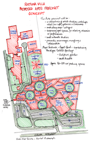
Document - Fortuna - Villa Proposed Arts Precinct Concept, Abt 2000
... While early proposals to turn the historic Fortuna Villa Estate into a public arts precinct (similar to Melbourne's Abbotsford Convent) gained community traction, the site has transitioned. ...While early proposals to turn the historic Fortuna Villa Estate into a public arts precinct (similar to Melbourne's Abbotsford Convent) gained community traction, the site has transitioned. ...While early proposals to turn the historic Fortuna Villa Estate into a public arts precinct (similar to Melbourne's Abbotsford Convent) gained community traction, the site has transitioned. The iconic gold rush mansion and grounds at 22 Chum Street is now a private residence and exclusive community space for the neighboring residential development, offering public functions and high teas by booking. The Tomkinson Group gained approval in 2016 to provide key town planning, engineering, surveying and project management services for the redevelopment of Bendigo’s iconic Fortuna Villa. They have been involved in consultation with Heritage Victoria, Council Planning, Heritage & Engineering, Environmental, Landscape and Heritage consultants all working cooperatively towards a sensitive urban renewal residential design for the site. The planning permit application was approved in 2016 and construction is set to start in late 2017. The residential development is great opportunity for the proposed re-invigoration of Bendigo’s historic “Fortuna Villa”, and Tomkinson Group is proud to be an integral part of the process. The concept consists of 79 high end architecturally designed townhouses, built to subtly enjoy the beautiful views and acres of parkland once part of the mansion estate. The exciting 55 million dollar project proposed for the mansion grounds will sensitively allow for a unique medium density housing development, diversifying the housing options available in Bendigo, whilst maintaining the integrity of the historic Villa and a portion of the grounds, which will be open to the public for high teas and functions. The project is not without its challenges however. The topography is steep, the soil has been contaminated and contains fill from mining days, and the historic aspects of the property must be treated with a great deal of care, however the positives far outweigh the negatives. Together with the architect and client we have resolved these issues to allow this exciting development to proceed. The site has an idyllic central city location, fantastic views of both Bendigo and the Villa itself, and the established grounds provide an attractive aesthetic basis for the proposed residences.Fortuna - Villa Proposed Arts Precinct Concept This item contains the following documents: 11217.72a Sketch of the proposed Arts Precinct off Chum Street 11217.72b 28 pages of proposed sketches and designs 11217.72c Four A3 size plans of Fortunanon-fictionbendigo, fortuna, george lansell, fortuna proposed arts precinct, tomkinson fortuna villa project -
 Sunshine and District Historical Society Incorporated
Photograph - The Hunt Club And Community Arts Centre opening 1988 Photographs, C. McGee, 26th November 1988
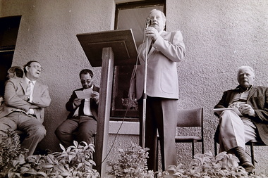
... The opening of the Hunt Club Community & Arts Centre is one of the most important cultural milestones in Deer Park’s modern history — the moment when a 19th‑century hotel, once the social base of the Melbourne Hunt Club, was formally reborn as a community arts precinct....The opening of the Hunt Club Community & Arts Centre is one of the most important cultural milestones in Deer Park’s modern history — the moment when a 19th‑century hotel, once the social base of the Melbourne Hunt Club, was formally reborn as a community arts precinct. ...The opening of the Hunt Club Community & Arts Centre is one of the most important cultural milestones in Deer Park’s modern history — the moment when a 19th‑century hotel, once the social base of the Melbourne Hunt Club, was formally reborn as a community arts precinct.Dr Jim Cairns Opening Hunt Club 728the hunt club and community arts centre, ballarat road, deer park, jim cairns