
Showing 272 items matching "mile creek"
-
 Otway Districts Historical Society
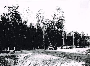
Photograph, Beechy: At 10 mile creek, 1900
... Beechy: At 10 mile creek....Colac; Beech Forest; railway; 10 mile creek; Water Tanks;...At 10 mile creek (Water Tanks) during the building of the Colac-Beech Forest railway in 1900....Colac; Beech Forest; railway; 10 mile creek; Water Tanks; At 10 mile creek (Water Tanks) during the building of the Colac-Beech Forest railway in 1900. ...At 10 mile creek (Water Tanks) during the building of the Colac-Beech Forest railway in 1900.colac; beech forest; railway; 10 mile creek; water tanks; -
 The Beechworth Burke Museum
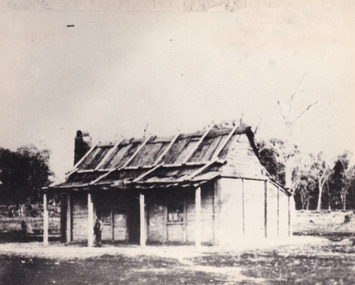
Photograph - Photograph - Reproduction, 1868
... ...eleven mile creek...This image, taken in 1868, is of of the Kelly family Homestead, located in Eleven Mile Creek, Greta West, Victoria. Ned Kelly built the homestead for his mother and siblings in 1877....Eleven Mile Creek, Greta West, Victoria...This image, taken in 1868, is of of the Kelly family Homestead, located in Eleven Mile Creek, Greta West, Victoria. Ned Kelly built the homestead for his mother and siblings in 1877. ...This image, taken in 1868, is of of the Kelly family Homestead, located in Eleven Mile Creek, Greta West, Victoria. Ned Kelly built the homestead for his mother and siblings in 1877.This photo of the Kelly family homestead, which is now in ruins, is one of very few images of the Kelly family's home that were taken, and as a rare glimpse of a site that was central both to Ned Kelly's personal story, but also the site of many skirmishes and arrests.Black and white rectangular photograph printed on matte photographic paper, mounted on board.obverse: sticky tape reside along the top edge reverse: 3545-2 kelly album, ned kelly, homestead, eleven mile creek, burke museum, kelly family -
 Otway Districts Historical Society
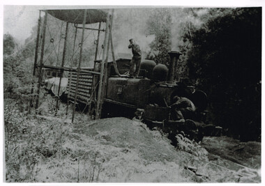
Photograph, Les Ogden, Locomotive 14A taking water at 10 mile tank, 1960-61
... colac; beech forest; ten mile creek; locomotive 14a; w. brady; l. ogden; railway;...10 Mile Creek, Bw. Barongarook and Birnam, Victoria, 3249, Australia...It was very near the end. colac; beech forest; ten mile creek; locomotive 14a; w. brady; l. ogden; railway; Locomotive 14A and a mixed goods trucks taking water at 10 mile tank in c.1960=61. ...By 1960/61 all the factors operating against a narrow gauge railway were in place for the Colac-Beech Forest line. As well as using a 2-6-2 Tank engine over 60 years old, 14A, the train by this stage only had a louvre van, two NQ trucks and a guard's van to bring to Colac. It was very near the end.Locomotive 14A and a mixed goods trucks taking water at 10 mile tank in c.1960=61. The driver controlling the water is W. Brady while the fireman, Les Ogden, peers into the smoke box. B/W.colac; beech forest; ten mile creek; locomotive 14a; w. brady; l. ogden; railway; -
 Koorie Heritage Trust
Book, Barned, Betty Jean, Woodend : On the Five Mile Creek, 1985
... Woodend : On the Five Mile Creek...Woodend : On the Five Mile Creek Book Barned, Betty Jean THE DOMINION PRESS-HEDGES AND BELL ...7-174 P.; plates; tables; 21 cm.woodend - history -
Art Gallery of Swan Hill
Drawing, JESS, Elizabeth, Nine mile creek at dusk, Broken Hill, 1992
... Nine mile creek at dusk, Broken Hill...Nine mile creek at dusk, Broken Hill Drawing JESS, Elizabeth ... -
 Bendigo Historical Society Inc.
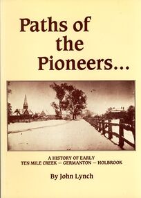
Book - STRAUCH COLLECTION: PATHS OF THE PIONEERS
... History-NSW-Holbrook-Germanton-Ten Mile Creek...Soft covered book Paths of the Pioneers, A history of early Ten Mile Creek - Germanton - Holbrook , compiled from the files of the newspapers which have served Germanton, Holbrook, Albury and Wagga Wagga, 104 pages with a map and black & white photographs....HISTORY Australian new south wales History-NSW-Holbrook-Germanton-Ten Mile Creek John Lynch Soft covered book Paths of the Pioneers, A history of early Ten Mile Creek - Germanton - Holbrook , compiled from the files of the newspapers which have served Germanton, Holbrook, Albury and Wagga Wagga, 104 pages with a map and black & white photographs. ...Soft covered book Paths of the Pioneers, A history of early Ten Mile Creek - Germanton - Holbrook , compiled from the files of the newspapers which have served Germanton, Holbrook, Albury and Wagga Wagga, 104 pages with a map and black & white photographs.John Lynchhistory, australian, new south wales, history-nsw-holbrook-germanton-ten mile creek -
 The Beechworth Burke Museum
Photograph - Photograph - Reproduction, Unknown c1852-1940
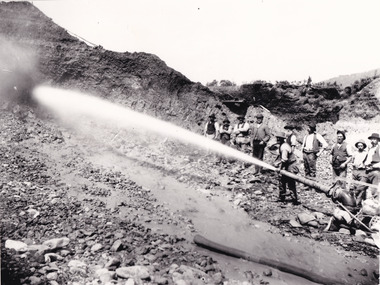
... ...Three Mile Creek...The miners are located in the Three Mile Creek division, in the Beechworth Mining District established January 4th 1858 under An Act for Amending the Laws Relating to the Goldfields by the Governor-in-Council. ...Beechworth Mining District Mining Three Mile Creek Division Three Mile Creek Black and white rectangular photograph printed on matte photographic paper, unmounted print. ...Depicted in the photograph are ten miners standing at a cliff face using a high pressure hose, in Beechworth, Victoria. The miners are located in the Three Mile Creek division, in the Beechworth Mining District established January 4th 1858 under An Act for Amending the Laws Relating to the Goldfields by the Governor-in-Council. The Ovens Gold Rush began at Beechworth in February 1852 and was followed by Yackandandah and the 'Indigo Goldfield'. The strategies applied to mining in Beechworth were distinct in comparison to other goldfields in Victoria such as Bendigo and Ballarat. The miners in Beechworth utlised 'hydraulic sluicing' to remove washdirt, the long water races and deep tailraces constructed through solid rock with an estimated 900 miles of water races cut through the Beechworth fields by 1880, demonstrating great engineering feats. The photograph taken is significant as it is a visual representation of the mining strategy, 'hydraulic sluicing' that was particularly unique to the Beechworth mines, particularly in Victoria and an engineering feat.Black and white rectangular photograph printed on matte photographic paper, unmounted print.beechworth mining district, mining, three mile creek division, three mile creek -
 The Beechworth Burke Museum
Photograph - Photograph - Reproduction, W. D. Gibbon, Early 1900s
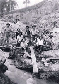
... ...three mile creek...This photograph was taken in 1911 at Three Mile Creek, about five kilometers south of Beechworth town. ...This photograph was taken in 1911 at Three Mile Creek, about five kilometers south of Beechworth town. ...This photograph was taken in 1911 at Three Mile Creek, about five kilometers south of Beechworth town. Significant digging took place at this location from late 1855, which led to a flood of workers and stores to follow, though daily earnings were slim compared to the nearby Woolshed site. This remained the case even after workers at Three Mile Creek attempted to protest around Beechworth during an election in November 1855. Three Mile Creek was one of seven significant divisions of the Beechworth Mining District formalised by the Governor-in-Council in 1858, though by the time this photograph was taken, the boundaries of the original seven districts had shifted to create seventeen divisions. The Three Mile Goldfields was a site of rich alluvial gold deposits located about 5km south of Beechworth in Victoria. Today, the location of this gold deposit is called Baarmutha. It was a popular area for gold mining in the 1850s but became largely abandoned by the following decade. In 1865, a man named John Pund (a man second from the left in the back row of this photograph shares this surname) recognized that the area could be potentially rich if a better water supply could be obtained. He secured a 15 year license with three other miners. Within the next five years, these men had constructed 19 km of water race going from Upper Nine Mile Creek to Three Mile Creek. By 1881, these four men had delivered 950,000 gallons to the Three Mile Sluicing area which is depicted in this photograph. Pund would later go into partnership with John Alston Wallace who would become owner of the Star Hotel in Beechworth. The Three Mile sluicing location continued to be operational until 1950. The eleven miners in this photograph are: Back row: Led Guthrie, P. Pund, F. Beel, [Unknown] Miller Front row: Paddy McNamara, J. King, W. Beel, [Unknown] Garland, J. Clarke, J. Ryan, H. Bartsh In the background of the photograph is a huge dirt wall that appears to suffer damage caused by hydraulic sluicing. Hydraulic sluicing is a specialised mining technique that involves directing high pressure water flows at dirt to uncover gold. The technique played a significant role in shaping Beechworth's landscape during the gold rush to create the topography seen today.The search for gold is ingrained into the history of Victoria and therefore, images like this one which portray an open cut sluicing site can reveal important information for society and technology for the date when the photograph was taken. This image is of important historical significance for its ability to convey information about sluicing and the methods used to find gold in the late 1800s and early 1900s. It also shows a location where sluicing was undertook which provides insight into the impact of sluicing on the environment at a time when it was done. Images, like this one, of Australian gold rush history can reveal important information about the social and environmental impact of this period. This image depicts diggers standing in a mining location and therefore, this image has the capacity to reveal or support significant information for researchers studying the fashion and social status of diggers in Australia in approximately 1911. It can also provide information on the landscape of Australia in this period and the impact of mining for gold on both society and the Australian landscape. The Burke Museum is home to a substantial collection of Australian mining photographs which can be used to gain a deeper understanding into life on the gold fields, technology used in mining, the miners themselves and the impact of the gold digging on the environment.Black and white / sepia rectangular reproduced photograph printed on glossy photographic paper mounted on board.beechworth, beechworth museum, mining, mining team, three mile creek, sluicing, hydraulic sluicing, photography, gold sluicing, gold mining, pund mining -
 The Beechworth Burke Museum
Photograph
... ...Three Mile Creek...Three Mile was a part of the Beechworth Mining District which was established in 1858. The District contained seven divisions: Spring Creek, Snake Valley, Three Mile Creek, Buckland, Woolshed, Yackandandah and Omeo. ...Beechworth Mining District Three Mile Creek Division Three Mile Creek three mile mine water race water races Mining pipe Baarmutha Gold Mining Sluicing Reverse: SW-50-1 / 1997 3140 / unreadable pencil markings Black and white square photograph printed on matte photographic paper. ...Taken in the 1950s, depicted is a crowd of men, women and children in a mine cutting at the Three Mile Mine, Baarmutha. The majority of the crowd do not appear to be mine workers. Some appear to be inspecting or interacting with the equipment. Three Mile was a part of the Beechworth Mining District which was established in 1858. The District contained seven divisions: Spring Creek, Snake Valley, Three Mile Creek, Buckland, Woolshed, Yackandandah and Omeo. Over time the role of Mining Districts was reduced until the Beechworth Mining District, and other Mining Districts in the area, was put under the administration of the Mines Department in 1975. Water races were commonly used in gold mining as the miners require large volumes of water to separate the gold from the dirt. Beechworth was the site of many firsts in Victorian colonial goldfield water management. Laws and regulations for water management and the control of water rights were established at Beechworth. The first Victorian water permits were also issued there, and the first sales of water for mining. This photograph is historically significant as an example of the importance of the gold rush in Beechworth. The photograph also depicts water infrastructure which has a significant history regarding usage and policy development within the Beechworth Mining District. Black and white square photograph printed on matte photographic paper.Reverse: SW-50-1 / 1997 3140 / unreadable pencil markingsbeechworth mining district, three mile creek division, three mile creek, three mile mine, water race, water races, mining, pipe, baarmutha, gold mining, sluicing -
 The Beechworth Burke Museum
Photograph, 1920-1950
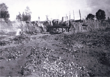
... ...three mile creek...The Three Mile Mine was unproductive until 1865 when John Pund and three other miners secured a fifteen year license and constructed a water race from Upper Nine Mile Creek to Three Mile Creek. In the early twentieth century Pund & Co. averaged over one thousand ounces of gold per year from the mine. ...The Three Mile Mine was unproductive until 1865 when John Pund and three other miners secured a fifteen year license and constructed a water race from Upper Nine Mile Creek to Three Mile Creek. In the early twentieth century Pund & Co. averaged over one thousand ounces of gold per year from the mine. ...This image taken between 1920-1930 depicts open-cut hydraulic sluicing at the Three Mile Mine, located about five kilometres south of Beechworth. Alluvial, or surface, mining began on this site in the 1850s, but was soon replaced by hydraulic sluicing methods. By the start of 1880 it is estimated that nine hundred miles of water races had been cut though soil and rock in the Beechworth district. Hydraulic sluicing employs high pressure jets of water to blast away large areas of earth and wash it down to be run through a sluice box. Gold gets caught in the sluice and the remaining slurry is washed away. Large water quantities were required for hydraulic sluicing, and the long water races and deep tailraces that were constructed were considered great engineering feats. This method of mining is extremely effective, but causes significant environmental damage and impacts to waterways and agricultural operations. Miners at Beechworth built extensive networks of races and dams to secure reliable supplies of water on a scale far greater than elsewhere in Victoria. By the 1880s Beechworth's water barons continued to hold more than half of all the water right licences on issue and undertook sluicing operations on a massive scale. The manipulation of surface and ground water via race networks was well planned and recorded in detail by local mining surveyors. The maps that were created, combined with modern geo-spatial technologies, provide a vital key in understanding the great lengths to which miners went to capture and control critical water resources. Today, Three Mile mine is called Baarmutha. The Three Mile Mine was unproductive until 1865 when John Pund and three other miners secured a fifteen year license and constructed a water race from Upper Nine Mile Creek to Three Mile Creek. In the early twentieth century Pund & Co. averaged over one thousand ounces of gold per year from the mine. After Pund's death in 1915, GSG Amalgamated Co operated the site, continuing sluicing until 1950. This image of hydraulic sluicing methods shows the extent of water-works engineering in the landscape. This photograph has historic and research potential for understanding changes to the landscape, the evolution of mining methods, and the extensive construction, manipulation and management of water networks in the Beechworth district. Black and white rectangular photograph on matte paperReverse: 7597-1 / Sluice Mining / Copied from original on loan from Webb (Qld) / Donated Nov 2009 / Baarmutha Three Mile Mine c1920-1950 / Managed by the Plain Bros then Parkinsons / Current Location is: Beechworth Animal Shelter / used for Baarmuthaburke museum, beechworth museum, beechworth, gold fields, gold rush, victorian gold rush, hydraulic sluicing, spring creek, netwown falls, mining tunnels, water races, tailraces, gold ming history, colonial australia, australian gold rushes, mining technology, beechworth historic district, indigo gold trail, indigo shire, john pund, water manipulation, water engineering, three mile creek, three mile mine, water race, large-scale mining methods, historical mining construction, alluvial mining, mining environmental impacts, baarmutha, water barons -
Clunes Museum
Book, Royal Readers - Fifth Reading Book
... If School number 740 is correct then; Tourello (Primary School No. 740; previously known as Sheepwash Common School No. 740 1864-1868, Sheepwash Primary School 1868-1877) Could have been locally known as Mile Creek State School?...Hand written in black ink cursive; Kenneth McKenzie, Mile Creek State School No. 1110 or 140 or 740. ...If School number 740 is correct then; Tourello (Primary School No. 740; previously known as Sheepwash Common School No. 740 1864-1868, Sheepwash Primary School 1868-1877) Could have been locally known as Mile Creek State School? royal reader primary school text Hand written in black ink cursive; Kenneth McKenzie, Mile Creek State School No. 1110 or 140 or 740. ...If School number 740 is correct then; Tourello (Primary School No. 740; previously known as Sheepwash Common School No. 740 1864-1868, Sheepwash Primary School 1868-1877) Could have been locally known as Mile Creek State School?Hard cover, dark blue front cover pages 1-416 (some back pages missing), contains stories, poetry and word meanings and their context.Hand written in black ink cursive; Kenneth McKenzie, Mile Creek State School No. 1110 or 140 or 740. There are scribbles in coloured pencil on the inside front cover.royal reader, primary school text -
 The Beechworth Burke Museum
Audio - Oral History, Jennifer Williams, Evelyn Jensen, 13th April 2000
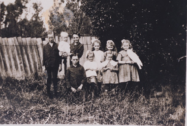
... ...three mile creek...mile to their house. This was because they have no access to water at their home. This lack of water also meant they had to either bathe in the creek or carry the water back home for a bath. ...Mytleford Road Beechworth three mile creek three mile beechworth twin nozzleman Goldrush gold rush work mother young mother children siblings baby grandmother father isolation bush water watertanks kerosene tins wash day bath day creek gardening provide poor money oral history twentieth century recording story Evelyn Jensen / This is a digital copy of a recording that was originally captured on a cassette tape. ...Miss Evelyn Jensen was born in 1908 near Mytleford Road in Beechworth. Miss Jensen was a twin but she also had twelve brothers and sisters. Miss Jensen went to school when she was nine years old but did not enjoy it. Her father was a nozzleman and had a role in finding and collecting gold. More specifically, a nozzleman operated a steel barrel with an interchangeable brass nozzle that sprayed high pressure water onto rock and similar surfaces. This broke down the surface for gold to be found. Unfortunately, when he began most of the gold was already gone. Miss Jensen's mother died when Miss Jensen was sixteen. As a result, Miss Jensen had to take care of the children and run the house. This included looking after a few months old baby. Her father was away at work most days so all of the responsibility fell on her. Her grandmother was present but she was too old to help Miss Jensen. Miss Jensen and her family lived a very long way from the main town and often had to carry kerosene tins full of water half a mile to their house. This was because they have no access to water at their home. This lack of water also meant they had to either bathe in the creek or carry the water back home for a bath. On wash day, they washed their clothes in the creek too. Miss Jensen never married but continued to provide for her family. She spent her days gardening and cooking. They did not have much money so gardening was a way that they provided food for themselves. This oral history recording was part of a project conducted by Jennifer Williams in the year 2000 to capture the everyday life and struggles in Beechworth during the twentieth century. This project involved recording seventy oral histories on cassette tapes of local Beechworth residents which were then published in a book titled: Listen to what they say: voices of twentieth century Beechworth. These cassette tapes were digitised in July 2021 with funds made available by the Friends of the Burke.Miss Jensen's oral history is significant because it demonstrates the struggles of living remotely during this early part of the twentieth century. When Miss Jensen's mother died, she had to take on a lot of responsibility and did not have much support. This history sheds light on these struggles of being a young caregiver but it also gives details on how large families lived in isolated places. An example of this is the way that Miss Jensen often had to do the washing in the creek because that was the only place there was running water. In addition, Miss Jensen's story is significant because her father was a nozzleman. It indicates one of the processes was used to find gold. This oral history account is socially and historically significant as it is a part of a broader collection of interviews conducted by Jennifer Williams which were published in the book 'Listen to what they say: voices of twentieth-century Beechworth.' While the township of Beechworth is known for its history as a gold rush town, these accounts provide a unique insight into the day-to-day life of the town's residents during the 20th century, many of which will have now been lost if they had not been preserved.This is a digital copy of a recording that was originally captured on a cassette tape. The cassette tape is black with a horizontal white strip and is currently stored in a clear flat plastic rectangular container. It holds up 40 minutes of recordings on each sideEvelyn Jensen /mytleford road, beechworth, three mile creek, three mile beechworth, twin, nozzleman, goldrush, gold rush, work, mother, young mother, children, siblings, baby, grandmother, father, isolation, bush, water, watertanks, kerosene tins, wash day, bath day, creek, gardening, provide, poor, money, oral history, twentieth century, recording, story -
Federation University Historical Collection
Reports, Thylacines and Large Predators Sightings, 1950-2011, 1950-2011
... ...mile creek...The folder was collected for research being conducted by David Waldron. australian mythical animals collection david waldron tiger greenwald tasmanian tiger roberts wadsworth mary wadsworth portland leo gillick merino ann matthews h. mincham footprint helena lucas cape bridgewater wilbert wilson puma paw rocklands reservoir paw cast emmaville panther mulgoa jack victory samela harris narrabri c.j. johnson wandsworth robertson edward hallstron yetman d. liddicoot f. hallam liger ben lomand ben lomand panther methvern park john hutton black mountain elvy adams joe clifford armidale australian marsupial cat glenn innes barraba manilla uralla stan wyatt ashford emaville kingston laurence miller a.t. o'farrell pad marks edward hallstrom tasmanian devil wonthaggi jim drodge cyril maurier j. wright jack brennocks marsupial wolf hyaena b.l. meeby circus animals blue mountains jack duane coff's harbour daylesford lyonville j.r. templeton otways p.w. hunt emmaville panther dingos coolatai panther wilson's promontory hambley-clark mark foster broken hill puma tarnagulla tarnagulla puma jan juc grampians tom croderick clifford andrews bunyip wedderburn john lavery mt korong rare fauna research society peter chappell denmark mt barker mike voss ernie palm southern pantgher yowie min min mongarlowe river monga state forest john reid thylacine prospect reservoir sugarloaf john higgins kyneton ravenswood bendigotom austin hamilton ron strachan samuel wilson albert austin jaguars inverell r.s. paterson ian lobsey black sal new england panther kingstown a.f. o'farrell mile creek Folder of newsclips and articles relating to "Big Cats", Thylacines, and other large predators ...The folder or correspondence is the result of a Freedom of Information request made to the Department of Sustainability and Environment in 2011. The folder was collected for research being conducted by David Waldron.Folder of newsclips and articles relating to "Big Cats", Thylacines, and other large predators. * The Argus, 04 May 1940 - 'Strange Animal a Dog' at Daylesford (Lyonville) sighted by J.R. Templeton australian mythical animals collection, david waldron, tiger, greenwald, tasmanian tiger, roberts wadsworth, mary wadsworth, portland, leo gillick, merino, ann matthews, h. mincham, footprint, helena lucas, cape bridgewater, wilbert wilson, puma paw, rocklands reservoir, paw cast, emmaville, panther, mulgoa, jack victory, samela harris, narrabri, c.j. johnson, wandsworth, robertson, edward hallstron, yetman, d. liddicoot, f. hallam, liger, ben lomand, ben lomand panther, methvern park, john hutton, black mountain, elvy adams, joe clifford, armidale, australian marsupial cat, glenn innes, barraba, manilla, uralla, stan wyatt, ashford, emaville, kingston, laurence miller, a.t. o'farrell, pad marks, edward hallstrom, tasmanian devil, wonthaggi, jim drodge, cyril maurier, j. wright, jack brennocks, marsupial wolf, hyaena, b.l. meeby, circus animals, blue mountains, jack duane, coff's harbour, daylesford, lyonville, j.r. templeton, otways, p.w. hunt, emmaville panther, dingos, coolatai panther, wilson's promontory, hambley-clark, mark foster, broken hill, puma, tarnagulla, tarnagulla puma, jan juc, grampians, tom croderick, clifford andrews, bunyip, wedderburn, john lavery, mt korong, rare fauna research society, peter chappell, denmark, mt barker, mike voss, ernie palm, southern pantgher, yowie, min min, mongarlowe river, monga state forest, john reid, thylacine, prospect reservoir, sugarloaf, john higgins, kyneton, ravenswood, bendigotom austin, hamilton, ron strachan, samuel wilson, albert austin, jaguars, inverell, r.s. paterson, ian lobsey, black sal, new england panther, kingstown, a.f. o'farrell, mile creek -
Federation University Historical Collection
Reports, Big Cats Sightings and Stock Kills 2000-2011, 2000-2011
... ...four mile creek...The folder was collected for research being conducted by David Waldron. australian mythical animals collection david waldron Department of Primary Industries rangers peter walsh Warragul creek Binginwarri Coongulla Straford Licola Blanket Hill Darramin Blanket Hill Woodside BEach heyfield puma panther cowwarr glenmaggie bolands bluff darrimen bolands bluff binginnwarri dawson the springs mt taylor black range driffield west Snowy plains airstrip glenmaggie north jack smith lake munro briagaling dutson downs connors plain giffard west darriment Joyces Road Junction Giffard West wallaby creek south Gippsland Highway avon river orbost four mile creek Folder of reports of Big Cat by rangers. ...The folder or correspondence is the result of a Freedom of Informaition request made to the Department of Primary Industries in 2011. The folder was collected for research being conducted by David Waldron.Folder of reports of Big Cat by rangers. australian mythical animals collection, david waldron, department of primary industries, rangers, peter walsh, warragul creek, binginwarri, coongulla, straford, licola, blanket hill, darramin, blanket hill, woodside beach, heyfield, puma, panther, cowwarr, glenmaggie, bolands bluff, darrimen, bolands bluff, binginnwarri, dawson, the springs, mt taylor, black range, driffield west, snowy plains airstrip, glenmaggie north, jack smith lake, munro, briagaling, dutson downs, connors plain, giffard west, darriment, joyces road junction, giffard west, wallaby creek, south gippsland highway, avon river, orbost, four mile creek -
 The Beechworth Burke Museum
Photograph, 1920 - 1930
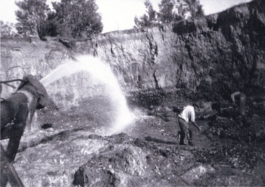
... three mile creek...It also shows the evolution of the mining methods and has potential for understanding future engineering endeavors in the context of victorian mine goldfields. three mile creek three mile goldfields three mile beechworth Goldfields #beechworth Hydraulic mining Hydraulic Sluice Burke Museum Reverse: Copied from original on loan from Webb (QLD)/ Donated Nov 2009/ Barnawatha Three Mile Mine c1920-1950/ Owned by Plain Bros then Parkinsons/ Managed by John Weir, Peter Jenson, Jack Cox/ Slicing. ...Taken between circa 1920 - 1930 this photograph depicts a Hydraulic water jet in the foreground and a man dressed in dark trousers, a white long sleeved shirt and broad-brimmed workers hat digging around in the Three Mile Mine at Barramutha. The mine was an important gold resource and was typically mined using a method known as hydraulic sluicing whereby high powered water jets are used to dislodge rock or move sediment. The remaining water sediment slurry is directed through sluice boxes to remove the gold. The Beechworth mining district was one of six mining districts established by the governor-in-council on 4th of January 1858 under the provisions of An Act for Amending the Laws Relating to the Goldfields (21 Vic no. 32).This photograph shows cultural and research value into the historical methods of hydraulic sluicing in the Beechworth mining disctrict. It also shows the evolution of the mining methods and has potential for understanding future engineering endeavors in the context of victorian mine goldfields.Black and White rectangular photograph printed on matte photographic paper. Reverse: Copied from original on loan from Webb (QLD)/ Donated Nov 2009/ Barnawatha Three Mile Mine c1920-1950/ Owned by Plain Bros then Parkinsons/ Managed by John Weir, Peter Jenson, Jack Cox/ Slicing. three mile creek, three mile goldfields, three mile beechworth, goldfields, #beechworth, hydraulic mining, hydraulic sluice, burke museum -
 The Beechworth Burke Museum
Photograph, 1920 - 1930
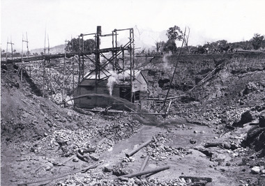
... three mile creek...It also shows the evolution of the mining methods and has potential for understanding future engineering endeavors in the context of victorian mine goldfields. three mile creek three mile goldfields three mile beechworth Goldfields #beechworth Hydraulic mining Hydraulic Sluice Burke Museum Reverse: Copied from original on loan from Webb (QLD)/ Donated Nov 2009/ Barnawatha Three Mile Mine c1920-1950 Minehead & Slicing/ Managed by John Weir, Peter Jensen, Jack Cox/ Owned by/ the Plain Bros then Parkinsons/ John worked for Pqarkinsons. ...Taken between circa 1920 - 1950 this photograph depicts the open mine in the Three Mile Mine at Barramutha. The mine was an important gold resource and was typically mined using a method known as hydraulic sluicing whereby high powered water jets are used to dislodge rock or move sediment. The remaining water sediment slurry is directed through sluice boxes to remove the gold. The Beechworth mining district was one of six mining districts established by the governor-in-council on 4th of January 1858 under the provisions of An Act for Amending the Laws Relating to the Goldfields (21 Vic no. 32).This photograph shows cultural and research value into the historical methods of hydraulic sluicing in the Beechworth mining disctrict. It also shows the evolution of the mining methods and has potential for understanding future engineering endeavors in the context of victorian mine goldfields.Black and White rectangular photograph printed on matte photographic paper.Reverse: Copied from original on loan from Webb (QLD)/ Donated Nov 2009/ Barnawatha Three Mile Mine c1920-1950 Minehead & Slicing/ Managed by John Weir, Peter Jensen, Jack Cox/ Owned by/ the Plain Bros then Parkinsons/ John worked for Pqarkinsons. three mile creek, three mile goldfields, three mile beechworth, goldfields, #beechworth, hydraulic mining, hydraulic sluice, burke museum -
 The Beechworth Burke Museum
Photograph, Circa 1920 - 1950
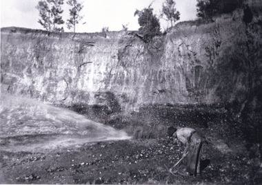
... three mile creek...It also shows the evolution of the mining methods and has potential for understanding future engineering endeavors in the context of victorian mine goldfields. three mile creek three mile goldfields three mile beechworth Goldfields #beechworth Hydraulic mining Hydraulic Sluice Burke Museum Reverse: 7597.3/ Copied from original on loan from Webb (QLD)/ Donated Nov 2009/ Barnawatha Three Mile Mine 1920-1950/ Owned by Plain Bros then Parkinsons/ Managed by John Weir, Peter Jenson, Jack Cox/ Slicing. ...Taken between circa 1920 - 1950 this photograph depicts a man dressed in dark trousers, a white long sleeved shirt and broad-brimmed workers hat digging around in the Three Mile Mine at Barramutha. The mine was an important gold resource and was typically mined using a method known as hydraulic sluicing whereby high powered water jets are used to dislodge rock or move sediment. The remaining water sediment slurry is directed through sluice boxes to remove the gold. The Beechworth mining district was one of six mining districts established by the governor-in-council on 4th of January 1858 under the provisions of An Act for Amending the Laws Relating to the Goldfields (21 Vic no. 32). This photograph shows historic and research value into the historical methods of hydraulic sluicing in the Beechworth mining disctrict. It also shows the evolution of the mining methods and has potential for understanding future engineering endeavors in the context of victorian mine goldfields. Black and white rectangular photograph printed on matte photographic paper.Reverse: 7597.3/ Copied from original on loan from Webb (QLD)/ Donated Nov 2009/ Barnawatha Three Mile Mine 1920-1950/ Owned by Plain Bros then Parkinsons/ Managed by John Weir, Peter Jenson, Jack Cox/ Slicing. three mile creek, three mile goldfields, three mile beechworth, goldfields, #beechworth, hydraulic mining, hydraulic sluice, burke museum -
 Greensborough Historical Society
Newspaper Clipping, Diamond Valley Leader, Last drinks for Pat's pub, 13/03/2019
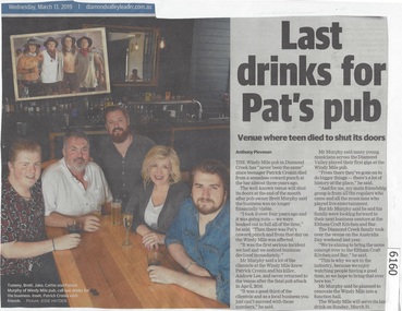
... mile...diamond creek...The Windy Mile pub in Diamond Creek has 'never been the same" since teenager Patrick Cronin died from a senseless coward punch at the bar almost three years ago.The Windy Mile will serve its last drink on Sunday, March 31 2019....The Windy Mile pub in Diamond Creek has 'never been the same" since teenager Patrick Cronin died from a senseless coward punch at the bar almost three years ago.The Windy Mile will serve its last drink on Sunday, March 31 2019. windy mile diamond creek patrick cronin Cronin family News article 1 page, black text. ...The Windy Mile pub in Diamond Creek has 'never been the same" since teenager Patrick Cronin died from a senseless coward punch at the bar almost three years ago.The Windy Mile will serve its last drink on Sunday, March 31 2019.News article 1 page, black text.windy mile, diamond creek, patrick cronin, cronin family -
Clunes Museum
Photograph - PHOTOGRAPHS
... Bates (Brother); and 'Afghan Worker' .2 Location "Mile Creek" sawmill...Bates (Brother); and 'Afghan Worker' .2 Location "Mile Creek" sawmill Two laminated black and white photographs of groups of men in front of what appears to be a mine site. ...Two laminated black and white photographs of groups of men in front of what appears to be a mine site..1 on Reverse; McClean great grandfather was Bates Four individuals noted on front as Richard Bates (Mine Manager); John Bates (Brother); ? Bates (Brother); and 'Afghan Worker' .2 Location "Mile Creek" sawmillbates, afghan -
 Orbost & District Historical Society
newspaper clipping, Orbost Forty Years Ago, 1929?
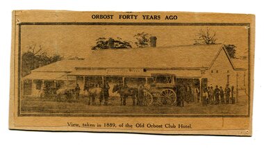
... In June 1889 there was a rush to Mackenzie River, about 28 miles from Orbost, on Twelve Mile Creek. An estimated 80 men rushed the ground, but yields were patchy and large numbers eventually left. ...In June 1889 there was a rush to Mackenzie River, about 28 miles from Orbost, on Twelve Mile Creek. An estimated 80 men rushed the ground, but yields were patchy and large numbers eventually left. ...The first hotel built in Orbost was the Club in 1885 an old wooden place on the corner built for J. A. Petersen of the Mitchell Hotel Bairnsdale, with the licence in the name of Mr Thomas Maguire (stepson of Petersen). In June 1889 there was a rush to Mackenzie River, about 28 miles from Orbost, on Twelve Mile Creek. An estimated 80 men rushed the ground, but yields were patchy and large numbers eventually left. They were coming and going almost daily.The Club Hotel was the first hotel built in Orbost and remains a significant building in the town. It was an important hub for the township with many whole town meetings held there.A yellowed black / white newspaper clipping of a photograph of people with a horse and cart outside a one-storey hotel building. It is glued onto a piece of cardboard.Caption at bottom - "View taken in 1889 of the Old Orbost Club Hotel"orbost-club-hotel -
Glenelg Shire Council Cultural Collection
Negative - Negative - Sapling Creek, Nelson, Victoria, c. 1936
... Entrance to the scrub near Sapling Creek, 7 miles from Nelson Vic...Entrance to the scrub near Sapling Creek, 7 miles from Nelson Vic Negative Negative - Sapling Creek, Nelson, Victoria Miss Zillah Maschmedt, photographer ...Transparency for black and white photo. Entrance to the scrub near Sapling Creek, 7 miles from Nelson Vic -
 The Beechworth Burke Museum
Photograph, Unknown c1925
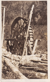
... The Wallaby Mine overlooks the Nine Mile Creek roughly eight kilometers from Beechworth. ...The Wallaby Mine overlooks the Nine Mile Creek roughly eight kilometers from Beechworth. ...Depicted in the photograph is mining machinery at Wallaby Mine, Hurdle Flat in Stanley, Victoria. The Wallaby Mine overlooks the Nine Mile Creek roughly eight kilometers from Beechworth. At the Wallaby Mine remains a twelve head stamp battery that was built in 1912 replacing the previous battery that was destroyed by bushfires. The stamp battery was used to extract gold by crushing rocks, a common method used in the late 1800s until the early 1900s. Gold mining heavily contributed to the development of Victoria since 1851, especially as a source of wealth in the 1800s.This photograph is historically significant as it provides insight into the mining industry around Beechworth in the 1920s including the development of mining technologies and the technological history of gold mining in Victoria.A black and white photograph featuring a mine in the center printed on matte photographic paper.Reverse: 83/ The Wallaby Mine Hurdle Flat about 1925/ 97.2504 mining, wallaby mine, hurdle flat -
Glenelg Shire Council Cultural Collection
Negative - Negative - Sapling Creek, Glenelg River, Nelson, Victoria, c. 1936
... Transparency for black and white photo. 'Sapling Creek' 26 miles upstream from mouth of Glenelg River at Nelson, Vic...Transparency for black and white photo. 'Sapling Creek' 26 miles upstream from mouth of Glenelg River at Nelson, Vic Negative Negative - Sapling Creek, Glenelg River, Nelson, Victoria Miss Zillah Maschmedt, photographer ...Transparency for black and white photo. 'Sapling Creek' 26 miles upstream from mouth of Glenelg River at Nelson, Vic -
 Orbost & District Historical Society
black and white photograph, C 1890s
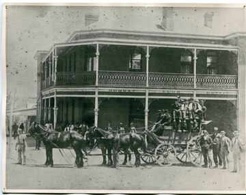
... In June 1889 there was a rush to Mackenzie River, about 28 miles from Orbost, on Twelve Mile Creek. An estimated 80 men rushed the ground, but yields were patchy and large numbers eventually left. ...In June 1889 there was a rush to Mackenzie River, about 28 miles from Orbost, on Twelve Mile Creek. An estimated 80 men rushed the ground, but yields were patchy and large numbers eventually left. ...The first hotel built in Orbost was the Club in 1885 an old wooden place on the corner built for J. A. Petersen of the Mitchell Hotel Bairnsdale, with the licence in the name of Mr Thomas Maguire (stepson of Petersen). William Archer was the proprietor at the time of the photograph. The coach driver was Sam Dyer and the coach is leaving for the goldfields at Combienbar. In June 1889 there was a rush to Mackenzie River, about 28 miles from Orbost, on Twelve Mile Creek. An estimated 80 men rushed the ground, but yields were patchy and large numbers eventually left. They were coming and going almost daily.The Club Hotel was the first hotel built in Orbost and remains a significant building in the town. It was an important hub for the township with many whole town meetings held there.A faded black / white photograph (with two copies) with a horse-drawn carriage loaded with men and the Orbost Club Hotel behind them. The photo is on a grey buff card.on back - " H. Adams. Driven by Sam Dyer - Leaving for the Combienbar Goldfields"orbost-club-hotel combienbar-goldfields -
 National Wool Museum
Steelyard
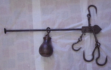
... Steelyard used for weighing wool and wheat on "Moor Park" on Yarriariak Creek, twenty miles from Horsham, Victoria....Steelyard used for weighing wool and wheat on "Moor Park" on Yarriariak Creek, twenty miles from Horsham, Victoria. Sheep stations management Wool Growing Hamilton Mr Robert G Sheep stations - management Steelyard used for weighing wool and wheat on "Moor Park" on Yarriariak Creek. ...Steelyard used for weighing wool and wheat on "Moor Park" on Yarriariak Creek, twenty miles from Horsham, Victoria.Steelyard used for weighing wool and wheat on "Moor Park" on Yarriariak Creek.sheep stations management, wool growing, hamilton, mr robert g, sheep stations - management -
 Coal Creek Community Park & Museum
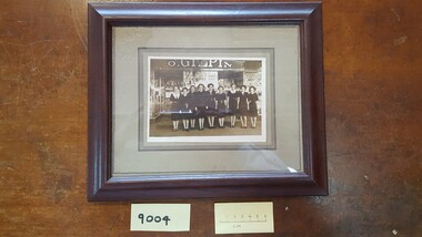
Photograph - O. Gilpin store staff Dimboola, c.1935, c. 1935
... Walker, V.Bond, I.Christensen, L.Mattinson, D.Shipsides, J. Miles, '(Coal Creek Historical Village per I. Devlin) Note : (M) Abbreviaton for Manager....Walker, V.Bond, I.Christensen, L.Mattinson, D.Shipsides, J. Miles, '(Coal Creek Historical Village per I. Devlin) Note : (M) Abbreviaton for Manager. on back of frame: Dimboola, 1935? ...This photo is reproduced in the book on Oliver Gilpin's life by his granddaughter Muriel Perry, titled 'Just a pocket for the money', 1995, p.84. The staff names have been labeled as 'Kath? (M), E.Myles, M.Haly, D. Walker, V.Bond, I.Christensen, L.Mattinson, D.Shipsides, J. Miles, '(Coal Creek Historical Village per I. Devlin) Note : (M) Abbreviaton for Manager.Photograph of nine female staff standing in front of O. Gilpins Dimboola store, circa 1935on back of frame: Dimboola, 1935? Names on back of photograph. -
 The Beechworth Burke Museum
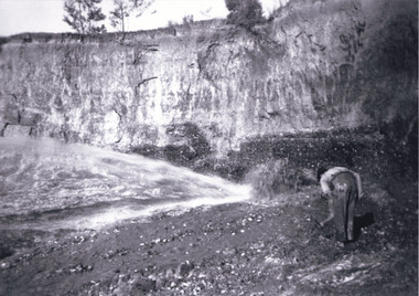
Photograph, c1920
... , Snake Valley, Three Mile Creek, Buckland, Woolshed, Yackandandah and Omeo. ..., Snake Valley, Three Mile Creek, Buckland, Woolshed, Yackandandah and Omeo. ...This photo shows the large mining cavity with a hydraulic sluicing machine in operation at Baarmutha Three Mile Mine, Beechworth . The Beechworth Mining District was one of six mining districts established by the Governor-in-Council on 4 January 1858 under the provisions of An Act for Amending the Laws Relating to the Goldfields (21 Vic no.32). The District was further divided into seven divisions: Spring Creek, Snake Valley, Three Mile Creek, Buckland, Woolshed, Yackandandah and Omeo. The boundaries of each of these divisions and of the whole district are described in the Governor-in-Council's proclamation printed in the Government Gazette, 5 January 1858, pages 3-5. Hydraulic mining is a form of mining that uses high-pressure jets of water to dislodge rock material or move sediment. In the placer mining of gold or tin, the resulting water-sediment slurry is directed through sluice boxes to remove the gold. It is also used in mining kaolin and coal.This photograph shows the impact the gold rush era had on Australia and the earth.A black and white rectangular photograph printed on photographic paperCopied from original on loan film (WEBB QLD) / Donated 2009 NOV/ Baarmutha Three Mile Mine c1920-1950/ Managed by John Weir Peter Jereen Jack Cox / Owned by Plain Bros then Parkinsons Sluicing.mining, gold fields, beechworth, gold rush, burke museum, photograph, mining cavity, hydraulic mining, hydraulic sluicing, baarmutha -
 The Beechworth Burke Museum
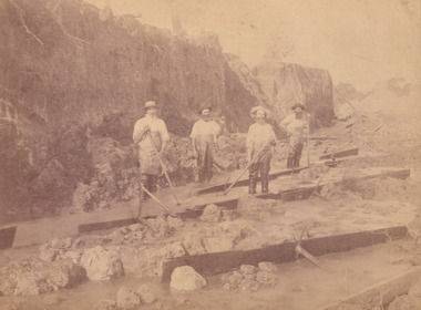
Photograph, c.1870
... Within the next five years, these men had constructed 19 km of water race going from Upper Nine Mile Creek to Three Mile Creek. By 1881, these four men had delivered 950,000 gallons to the Three Mile Sluicing area which is depicted in this photograph. ...Within the next five years, these men had constructed 19 km of water race going from Upper Nine Mile Creek to Three Mile Creek. By 1881, these four men had delivered 950,000 gallons to the Three Mile Sluicing area which is depicted in this photograph. ...This photograph was taken in approximately 1870 and depicts four male miners standing in mining sluice at the Three Mile Goldfields. These men are wearing typical attire for 1870s gold miners. They wear white shirts, tan coloured pants with water proof shoes and most of the men are wearing an apron to prevent their clothing from becoming too dirty from the mud. Each man is wearing a wide brim hat and hold large wooden tools used for sorting through the sluice. Three of the four men have full beards. The photograph was donated to the Burke Museum by R. Ziegenbein before 2001 but the photographer and the individuals captured in the photo are unknown. The image depicts the landscape of the Three Mile Goldfields during a period when open cut sluicing was undertaken to reach gold. Open cut sluicing is a method used to extract gold and other precious metals from beneath the surface of the earth. This technique involved the use of high-powered hoses which broke down the soil enabling miners to come along and search this soil for gold. After the gold rush of the early 1850s, diggers had to enlist the assistance of heavy machinery and techniques like hydraulic sluicing in order to reach gold because the surface alluvial gold had already been discovered and removed. This heavy machinery was not used until after 1853. The Three Mile Goldfields was a site of rich alluvial gold deposits located about 5 km south of Beechworth in Victoria. Today, the location of this gold deposit is called Baarmutha. It was a popular area for gold mining in the 1850s but became largely abandoned by the following decade. In 1865, a man named John Pund recognized that the area could be potentially rich if a better water supply could be obtained. He secured a 15 year license with three other miners. Within the next five years, these men had constructed 19 km of water race going from Upper Nine Mile Creek to Three Mile Creek. By 1881, these four men had delivered 950,000 gallons to the Three Mile Sluicing area which is depicted in this photograph. Pund was later go into partnership with John Alston Wallace who would become owner of the Star Hotel in Beechworth. The Three Mile sluicing location continued to be operational until 1950. Sluice box workers were a vital part of gold mining regardless of how inefficient they were in the recovery of gold. After using hydraulic sluicing to cut away the earth, miners would use the big wooden boxes depicted in the image to catch the earth which would then be sifted for gold. However, accidents would occur often which would result in the gold washing away and unable to be recovered. It was not a very efficient system because the gold, which was alluvial and thus very fine, would often pass through the sluice box undetected.The search for gold is ingrained into the history of Victoria and therefore, images like this one which portray an open cut sluicing site can reveal important information for society and technology for the date when the photograph was taken. This image is of important historical significance for its ability to convey information about sluicing and the methods used to find gold in the late 1800s and early 1900s. It also shows a location where sluicing was undertook which provides insight into the impact of sluicing on the environment at a time when it was done. Images, like this one, of Australian gold rush history can reveal important information about the social and environmental impact of this period. This image depicts diggers standing in a mining location and therefore, this image has the capacity to reveal or support significant information for researchers studying the fashion and social status of diggers in Australia in approximately 1870. It can also provide information on the landscape of Australia in this period and the impact of mining for gold on both society and the Australian landscape. The Burke Museum is home to a substantial collection of Australian mining photographs which can be used to gain a deeper understanding into life on the gold fields, technology used in mining, the miners themselves and the impact of the gold digging on the environment.Sepia toned rectangular photograph printed on matte photographic paper and mounted on board.[illegible] about 1870 / 97 2514.1 / 2594 30three mile goldfields, goldfields, 1870, 1870 gold, australia, australian landscape, miners, gold miners, diggers, gold diggers, beechworth, victoria, sluice box workers, sluicing, sluice, mining -
 Bendigo Historical Society Inc.
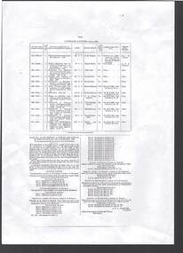
Document - BOARD OF WORKS, MELBOURNE: CONTRACTS ACCEPTED & LAND SALES FOR 1860
... Contracts accepted are for Raising and removing sunken ship Marilla; Removal of Toll-gate from Mount Alexander Road and re-erection of same at Middle Gully; Erection of toll-house on Melbourne/Ballarat Road near Ballan; Erection of toll-house on Bendigo Road at Kangaroo Flat; Castlemaine to Ballarat - Erection of toll-house at Campbell's Creek; Construction of 2870 chains of Lower Western Road, west of Camperdown; Erection of two bridges and other improvements on the Clunes to Amherst Road; Erection of timber bridge, & c., over Two-mile Creek - Beechworth to Bowman Forest; Formation of roadway at head of Buckland Gap - Beechworth to Bowman Forest; Construction of culvert, & c., Rowe's Creek - Beechworth to Bowman Forest; Ararat and South-western sea-board road - erection of bridge over Dennicull Creek and other improvements. ...Contracts accepted are for Raising and removing sunken ship Marilla; Removal of Toll-gate from Mount Alexander Road and re-erection of same at Middle Gully; Erection of toll-house on Melbourne/Ballarat Road near Ballan; Erection of toll-house on Bendigo Road at Kangaroo Flat; Castlemaine to Ballarat - Erection of toll-house at Campbell's Creek; Construction of 2870 chains of Lower Western Road, west of Camperdown; Erection of two bridges and other improvements on the Clunes to Amherst Road; Erection of timber bridge, & c., over Two-mile Creek - Beechworth to Bowman Forest; Formation of roadway at head of Buckland Gap - Beechworth to Bowman Forest; Construction of culvert, & c., Rowe's Creek - Beechworth to Bowman Forest; Ararat and South-western sea-board road - erection of bridge over Dennicull Creek and other improvements. ...Page 2223 titled Contracts Accepted - (Series 1860). Contracts accepted are for Raising and removing sunken ship Marilla; Removal of Toll-gate from Mount Alexander Road and re-erection of same at Middle Gully; Erection of toll-house on Melbourne/Ballarat Road near Ballan; Erection of toll-house on Bendigo Road at Kangaroo Flat; Castlemaine to Ballarat - Erection of toll-house at Campbell's Creek; Construction of 2870 chains of Lower Western Road, west of Camperdown; Erection of two bridges and other improvements on the Clunes to Amherst Road; Erection of timber bridge, & c., over Two-mile Creek - Beechworth to Bowman Forest; Formation of roadway at head of Buckland Gap - Beechworth to Bowman Forest; Construction of culvert, & c., Rowe's Creek - Beechworth to Bowman Forest; Ararat and South-western sea-board road - erection of bridge over Dennicull Creek and other improvements. Land Sales - 4 Lots - Elsternwick, parish of Prahran, County of Bourke; 2 Lots - Dandenong, County of Bourke; 20 Lots - Lillydale, Parish of Yering, County of Evelyn, 1 suburban Lot - County of Evelyn, Parish of Yering; 1 Allotment - Romsey, County of Bourke, Parish of Lancefield; 5 Lots - County of Mornington, Parish of Langwarrin, and 2 Lots - County of Mornington, Parish of Fingal. Lots to be sold at the Auction Rooms of Mr. William Perry, Great Collins Street, Melbourne. A F A Greaves, President, Office of the Board of Land and Works, Melbourne.bridge, construction, timber bridges, board of works, melbourne - contracts accepted & land sales, 'marilla', f m pingree, jno r bailey, robert heron, john gray, donald ross, hector mclean, c j glynn and co, john nicholls and co, michael cleary, thomas cairncross, brown and gibson, queen victoria, mr william perry, mr de castella, willoughby, barker, a f a greeves, board of land and works melbourne -
 Orbost & District Historical Society
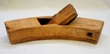
plane, early 20th century
... This roughing plane was used by Peter Jensen who came to Martin's Creek (35 miles north of Orbost) in 1890 having been told that Martin's Creek would be on the railway line. ...This roughing plane was used by Peter Jensen who came to Martin's Creek (35 miles north of Orbost) in 1890 having been told that Martin's Creek would be on the railway line. ...This roughing plane was used by Peter Jensen who came to Martin's Creek (35 miles north of Orbost) in 1890 having been told that Martin's Creek would be on the railway line. He was a cooper who made the casks from silver wattles. He cleared the area for farming and then built an accommodation house, Danebo.Ths item is an example of a woodworking tool used in the late 19th to early 20th century.Large smooth wooden roughing plane. It is curved and has a large metal blade. roughing-plane tool jensen-peter
