Showing 107 items matching "mount dandenong north"
-
 Mt Dandenong & District Historical Society Inc.
Photograph, The Gap at Kalorama 1913, 1913
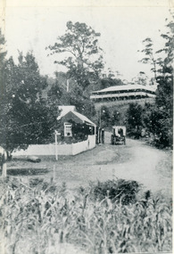
... ‘Mountjoy’ guest house. Mount Dandenong North Post Office. Jeeves coach....Farndons Community Hall 42 Falls Road Mt Dandenong yarra-valley-and-the-dandenong-ranges FiveWays Mountjoy Post Office Mt Dandenong North The Gap Jeeves coach The Gap Kalorama 1913. ‘Mountjoy’ guest house. Mount Dandenong North Post Office. ...1913 scene looking up to Mountjoy Guest House at the Kalorama Gap (FiveWays). Post Office and tea rooms with white picket fence. Jeeves Coach on the road. This photograph has a detailed inscription on the back handwritten by John Lundy-Clarke in 1974. The Gap Kalorama 1913. ‘Mountjoy’ guest house. Mount Dandenong North Post Office. Jeeves coach.fiveways, mountjoy, post office, mt dandenong north, the gap, jeeves, coach -
 Mt Dandenong & District Historical Society Inc.
Photograph, The Busy Corner, 1907
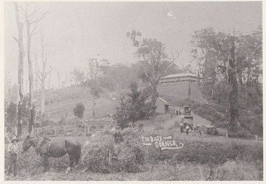
... ...mount dandenong north...Farndons Community Hall 42 Falls Road Mt Dandenong yarra-valley-and-the-dandenong-ranges jeeves theo hand fred jeeves isaac jeeves barbers road beulah tea rooms post office mount dandenong north mt dandenong north kalorama coach mountjoy “Jeeves Saddle” in 1907. ...View of Jeeves Saddle in 1907 showing everyday life and including important people and businesses from early settlement - Dodd's grocery and meat cutting carts; Beulah tea Rooms/Post Office; Mrs Hand, Fred Jeeves, Theo Hand.This photograph has a detailed inscription on the back handwritten by John Lundy-Clarke in 1974.“Jeeves Saddle” in 1907. Isaac Jeeves special strip of land Crown Allotment “C” 7 chains wide, lay between the sledge load of pea stalks and the far end of the verandah on Mrs Hand’s “Beulah Tea Rooms” which soon afterwards became the Mt Dandenong North Post Office. The coach road came up from the right behind the tall stump. The big woman in black was Mrs Hand. The wagon at the shop was Dodd’s grocery cart. The nearer wagon was the first coach on the mountain which had belonged to Briarty. The small cart was Dodd’s meat cutting cart. The elm trees are in the centre of the picture and above them is Price’s sign advertising their shop and newsagency. The big house is “Mountjoy” burnt 1975. Walker’s house is among the big trees left centre. Boy at horse’s head is Fred Jeeves. Boy on sledge is Theo Hand. The horse is “Blossom”. Barbers Road goes to the left from behind the elm trees.jeeves, theo hand, fred jeeves, isaac jeeves, barbers road, beulah tea rooms, post office, mount dandenong north, mt dandenong north, kalorama, coach, mountjoy -
 Mt Dandenong & District Historical Society Inc.
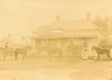
Photograph, Post Office and 'Mountjoy', Mt. Dandenong North, 1913
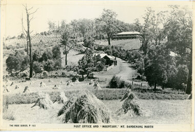
... The closed in far end of the verandah was the Mount Dandenong North Post Office. The large house is “Mountjoy” owned and run by the Jeeves Family from 1908 till 1943. ...The closed in far end of the verandah was the Mount Dandenong North Post Office. The large house is “Mountjoy” owned and run by the Jeeves Family from 1908 till 1943. ...Rose Series post card #182Copy of Rose Series postcard #182 showing Kalorama Gap in 1913. Haystacks in foreground with Mountjoy Guest House and Beulah Tea Rooms/Mt Dandenong North Post Office in centre. This photograph has a detailed inscription on the back handwritten by John Lundy-Clarke in 1974.Kalorama Gap in 1913 The elm trees are in the centre of the picture. One of these is really two as two suckers of the further tree were twisted together by Fred Jeeves in 1898 and grew as one tree. The other was planted in 1880. The shop is the shop of Mrs Eliza Hand and daughter Florence. The closed in far end of the verandah was the Mount Dandenong North Post Office. The large house is “Mountjoy” owned and run by the Jeeves Family from 1908 till 1943. It was built in 1905 by the Paynters who sold to Ellis Jeeves in 1908.He moved his line of coaches from “Kalorama” his old homestead and housed the horses in a line of stables behind “Mountjoy”. Price’s house, which contained their shop, the first one on the mountain, opened 1906, can be seen faintly behind the pine tree opposite the bend in the road, which was the main road then and now is Ridge Road. The Price’s house just shows in two tiny pieces, one on each side of the pine tree half way up. The house to the right of and high up the pine tree is Walker’s cottage which exists today opposite Jack Kidd’s home at the far edge of Lt 2 Village Settlement and was between Main Road and Barbers Road which runs down the left behind the elms. Walker’s homestead can be seen near left edge of picture 2/3 way up. The roof of the Methodist Church shows among trees left of picture. This, like Mrs Hand’s shop was built on portions separated from Isaac Jeeves’ Selection “C” known as Jeeves Saddle. kalorama gap, five ways, mountjoy, john lundy-clarke, beulah tea rooms, post office, fred jeeves, paynter, jeeves, frederick jeeves, price, walker, jack kidd -
 Mt Dandenong & District Historical Society Inc.
Photograph, Kalorama Gap Under Snow 1921, 1921
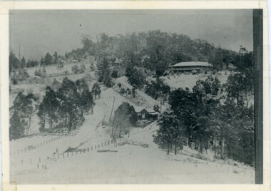
... Mrs Hands shop can be clearly seen, which was the Mount Dandenong North Post Office. The old Main Road runs up the centre of the picture and turns to the right and disappears behind “Mountjoy” the big guest house built by Paynters in 1905 and sold to Ellis Jeeves 1908, whose family ran it till 1943. ...Mrs Hands shop can be clearly seen, which was the Mount Dandenong North Post Office. The old Main Road runs up the centre of the picture and turns to the right and disappears behind “Mountjoy” the big guest house built by Paynters in 1905 and sold to Ellis Jeeves 1908, whose family ran it till 1943. ...View of Kalorama Gap under snow taken in 1921. Mountjoy Guest House is at top right and Beulah Tea Rooms is in the centre. This photograph has a detailed inscription on the back handwritten by John Lundy-Clarke in 1974.Kalorama Gap under snow 1921 The leafless elm trees are low in the centre and the dual nature of the nearer one can be clearly seen, two small suckers of the older farther tree being twisted together in 1898 by Fred Jeeves. The older tree was planted 1880. Mrs Hands shop can be clearly seen, which was the Mount Dandenong North Post Office. The old Main Road runs up the centre of the picture and turns to the right and disappears behind “Mountjoy” the big guest house built by Paynters in 1905 and sold to Ellis Jeeves 1908, whose family ran it till 1943. At the bend of the road behind the big pine tree and the dark blackwood can be seen faintly the gable of Price’s house that contained the first shop on the mount. Above it is H Walker’s cottage on Ridge Road that still exists, his homestead is on the left of the picture on the same level. Below this house and to the left can be seen Ted Prices hay and corn store. The present estate agency lies between these two buildings, on the road which had recently been built. This can be seen winding from the lower left corner of picture to the left of the elms. The CRB had recently fenced the road and this is clearly seen as it circles behind trees in the left centre. Barber’s Road crosses CRB Road to the left of the dray under the leafless elm and the Coach Road dives down to the right just behind the pair of blackwoods to right of the elms. The picture was taken from just above the boundary of Isaac Jeeves’s selection Crown Allotment “C” (Jeeves Saddle) which stretched across the Gap to the other side of Mrs Hand’s shop, monopolising the gap from 1871 to 1879. Price’s house remains partly as the small house – “Mirra Laken”. kalorama gap, fiveways, post office, mountjoy, guest house, snow -
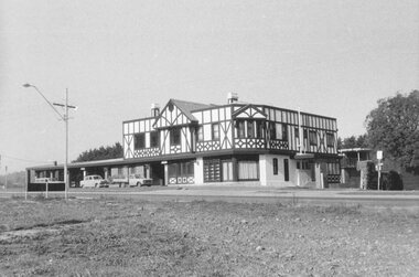 Ringwood and District Historical Society
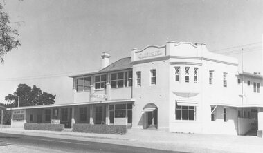
Photograph, Club Hotel, Mount Dandenong Road, Ringwood East 1973
... Ringwood and District Historical Society 125A Warrandyte Road Ringwood North melbourne Black and white photographs of Tudor style Club hotel Club Hotel, Mount Dandenong Road, Ringwood East 1973 Photograph ...Black and white photographs of Tudor style Club hotel -
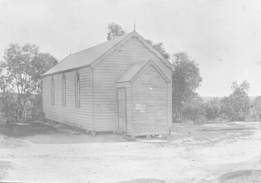 Ringwood and District Historical Society
Photograph, United Methodist Free Church Ringwood- 1904
... Ringwood and District Historical Society 125A Warrandyte Road Ringwood North melbourne Typed below large copy: "United Methodist Church 1904 - Cnr. Mt. Dandenong Rd. & Whitehorse Road." Black and white photograph (2 copies- 1 original mounted on lightly embossed cardboard, 1 larger copy) United Methodist Free Church Ringwood- 1904 Photograph ...Black and white photograph (2 copies- 1 original mounted on lightly embossed cardboard, 1 larger copy)Typed below large copy: "United Methodist Church 1904 - Cnr. Mt. Dandenong Rd. & Whitehorse Road." -
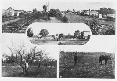 Ringwood and District Historical Society
Photograph, Photos from a Weekly Times newspaper article featuring images of early Ringwood and East Ringwood circa 1910 (6 photos), Circa 1910
... Ringwood and District Historical Society 125A Warrandyte Road Ringwood North melbourne Shops, houses and hotel(s) were originally regarded as being in central Ringwood and later as Ringwood East after the commercial and residential developments gradually centered further west around the Railway Station precinct after train services commenced Written on backing sheet, "Photos from Weekly Times. Check with H.A." Five photographs; Ringwood Railway Crossing; Ringwood Shopping Strip; Pruning Demonstration; Shops, houses and hotel(s) in Mount Dandenong ...Shops, houses and hotel(s) were originally regarded as being in central Ringwood and later as Ringwood East after the commercial and residential developments gradually centered further west around the Railway Station precinct after train services commencedFive photographs; Ringwood Railway Crossing; Ringwood Shopping Strip; Pruning Demonstration; Shops, houses and hotel(s) in Mount Dandenong Road; Ploughing.Written on backing sheet, "Photos from Weekly Times. Check with H.A." -
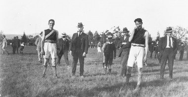 Ringwood and District Historical Society
Photograph, Footballers at Mount Dandenong Road Recreation Ground oval. c 1914
... North melbourne Man in centre with hat and pipe possibly A. J. (Jun) Sugden, headmaster of Wantirna School, and Bob Skerrett on right hand side with hat. Black and white photograph Footballers at Mount Dandenong ...Black and white photographMan in centre with hat and pipe possibly A. J. (Jun) Sugden, headmaster of Wantirna School, and Bob Skerrett on right hand side with hat. -
 Ringwood and District Historical Society
Photograph, Club Hotel, Mount Dandenong Road, East Ringwood in February 1960
... North melbourne Black and white photographs of Club Hotel February 1960 (1 original, three copies). The hotel has a long association with the Reddish family, thus given the name of "Daisy's Hotel". Included 2 copies of the photograph. Ryman Healthcare bought the site in 2019, including the garden supply business next door, making up a 2.2ha area. The proposal was for a $220 million retirement village to be built. The location is next to Ringwood Lake with the old hotel being knocked down in the early 2020s. Club Hotel, Mount Dandenong ...Black and white photographs of Club Hotel February 1960 (1 original, three copies). The hotel has a long association with the Reddish family, thus given the name of "Daisy's Hotel". Included 2 copies of the photograph. Ryman Healthcare bought the site in 2019, including the garden supply business next door, making up a 2.2ha area. The proposal was for a $220 million retirement village to be built. The location is next to Ringwood Lake with the old hotel being knocked down in the early 2020s. -
 Ringwood and District Historical Society
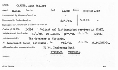
Document, M.B.E. Award Certificate
... North melbourne Award - M.B.E. Rank - Major Service - British Army Citation - Gallant and distinguished services in Italy. A4 size photocopy of M.B.E. award certificate presented to Allan Ballard Carter of 29 Mount Dandenong Road, Ringwood, Victoria by The Governor of Victoria at Government House, Melbourne, on 19/4/1950. ...A4 size photocopy of M.B.E. award certificate presented to Allan Ballard Carter of 29 Mount Dandenong Road, Ringwood, Victoria by The Governor of Victoria at Government House, Melbourne, on 19/4/1950.Award - M.B.E. Rank - Major Service - British Army Citation - Gallant and distinguished services in Italy. -
 Ringwood and District Historical Society
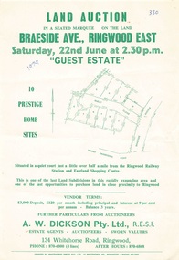
Flyer - Land Auction, Guest Estate, Ringwood East - 1974
... Ringwood and District Historical Society 125A Warrandyte Road Ringwood North melbourne Subdivision layout includes Mount Dandenong Road, Braeside Avenue and Guest Close, Ringwood East. ...Two copies of single page with green print advertising auction of ten home sites on Saturday 22nd June (1974). Details include subdivision map and vendor terms. Second copy of flyer includes handwritten notation of allotment sale prices.Subdivision layout includes Mount Dandenong Road, Braeside Avenue and Guest Close, Ringwood East. Agent: A.W. Dickson, 136 Whitehorse Road, Ringwood, Phone 870-6000, after hours 870-6868. Printed by Whitehorse Press Pty. Ltd., 14 Whitehorse Road, Ringwood, Phone 870-7855. -
 Ringwood and District Historical Society
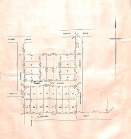
Card - Double-sided Display, Land Subdivision Map Samples
... Ringwood and District Historical Society 125A Warrandyte Road Ringwood North melbourne Side 1 - Layout of 20 residential allotments in Shasta Avenue, Merrilong Street, Northwood Street and Alexandra Road, Ringwood East, Victoria (Undated). Side 2 - Extract from Land Auction advertisement for sale of 23 allotments in Ridge Road, Oakley Street and Mount Dandenong Tourist Road, Mount Dandenong, Victoria - circa 1950s. ...Side 1 - Layout of 20 residential allotments in Shasta Avenue, Merrilong Street, Northwood Street and Alexandra Road, Ringwood East, Victoria (Undated). Side 2 - Extract from Land Auction advertisement for sale of 23 allotments in Ridge Road, Oakley Street and Mount Dandenong Tourist Road, Mount Dandenong, Victoria - circa 1950s. -
 Ringwood and District Historical Society
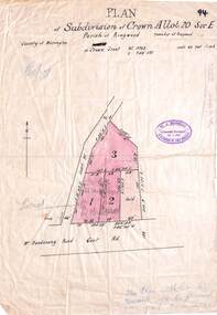
Map, Subdivision Plan - Crown Allotment 20 Section E, Parish of Ringwood, Township of Ringwood, County of Mornington. (Undated, circa 1920s)
... North melbourne Rubber-stamped with circa 1920s stamp of W.J. Bonwick, Licensed Surveyor, 19 Clarence Street, East Malvern, Telephone U4833. Wax/parchment paper printout of numbered subdivision allotments and store, corner of Mount Dandenong Road and Braeside Avenue, Ringwood. ...Wax/parchment paper printout of numbered subdivision allotments and store, corner of Mount Dandenong Road and Braeside Avenue, Ringwood.Rubber-stamped with circa 1920s stamp of W.J. Bonwick, Licensed Surveyor, 19 Clarence Street, East Malvern, Telephone U4833. -
 Ringwood and District Historical Society
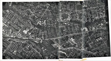
Photograph, Composite Aerial Views of Ringwood, Victoria - 1972
... Two composite black & white aerial photographs with north-facing view over Maroondah Highway, including Railway Station precinct, Civic Centre precinct, Eastland, Mount Dandenong Road, Bedford Road, Ringwood Street, Warrandyte Road, Mullum Road, Loughnan's Road....Two composite black & white aerial photographs with north-facing view over Maroondah Highway, including Railway Station precinct, Civic Centre precinct, Eastland, Mount Dandenong Road, Bedford Road, Ringwood Street, Warrandyte Road, Mullum Road, Loughnan's Road. ...Two composite black & white aerial photographs with north-facing view over Maroondah Highway, including Railway Station precinct, Civic Centre precinct, Eastland, Mount Dandenong Road, Bedford Road, Ringwood Street, Warrandyte Road, Mullum Road, Loughnan's Road.Department of Crown Lands and Survey. Maroondah Highway Project - Run 3 - 20.1.72 - 3,900' ASL. -
 Ringwood and District Historical Society
Photograph, Maroondah Highway East, Ringwood c1920. 'Paris Bakery - Baker and General Storekeeper' (Owned by the Herry Family.)
... Ringwood and District Historical Society 125A Warrandyte Road Ringwood North melbourne Image shows building on Maroondah Highway with two horse driven carts at front, and another gentleman holding a horse. Louis Herry had a bakery and general store in Lilydale and opened another in Mount Dandenong Road, opposite the Club Hotel. ...2 photographs (1 black and white, 1 sepia)Image shows building on Maroondah Highway with two horse driven carts at front, and another gentleman holding a horse. Louis Herry had a bakery and general store in Lilydale and opened another in Mount Dandenong Road, opposite the Club Hotel. His wife, Kate, mostly ran the Ringwood store. The store was previously owned by the Blood Bros, after they moved premises closer to the railway station. From the Place of Many Eagles book, "Louis was born in Purdu, France, in 1855, and came to Ringwood from Walhalla in 1887 and erected a weatherboard house and shop opposite the Club Hotel, using a Miner's Right to secure the land. When he arrived, Louis was a married man with three children, Leopold (1882), Marie (1884), John (1886). He had married Kate Handforth at Walhalla in 1879. In later years Elizabeth, Minellia, Louis and Denise were born. Kate's father was known as the midwife of the Gippsiand township because he had once been a fourth year medical student in England, but earnt a living as a goldbuyer in Victoria. Marie Herry would grow up remembering her grandfather calling sometimes at Ringwood; he would bring the children jubilee Mixture to eat and he carried a revolver in his pocket. Often he would play the violin while Marie would stepdance on the kitchen table." Leo served in WWI, whose name appears on the Ringwood Clocktower. -
 Ringwood and District Historical Society
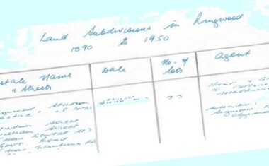
Document - Research Notes, Richard Carter, Land Subdivisions in Ringwood 1890-1950
... North melbourne Pg1 RINGWOOD STATION ESTATE LP3070 (Year?) Station Street, William Street (now Kendall Street), Wantirna Road, Station Street Pg1 RINGWOOD TOWNSHIP ESTATE LP5577 (1913) Station Road (now Warrandyte Road), Pratt Street (part now Aird Street), Whitehorse Road Pg2 RINGWOOD ORCHARD ESTATE LP4315 (1914) Brysons Road, Hillcrest Road, Anzac Avenue, Sulva Road Pg3 RINGWOOD RAILWAY ESTATE LP7522 (1918) Whitehorse Road (now Mount Dandenong Road), Dublin Road, Freeman Street, Patterson Street, Bona Street Pg4 THE RINGWOOD ESTATE LP7578 (1919) Warrandyte Road, Hobart Street, Paxton Street, Arnold Street Pg5 GARDEN FARMS ESTATE (LP?) ...Handwritten table listing main local pre-1950s subdivisions in the Ringwood area, with estate names, streets, number of allotments for sale, and where known, vendor agent, LP (Lodged Plan) title registration number, and auction/sale date, some with sale price.Pg1 RINGWOOD STATION ESTATE LP3070 (Year?) Station Street, William Street (now Kendall Street), Wantirna Road, Station Street Pg1 RINGWOOD TOWNSHIP ESTATE LP5577 (1913) Station Road (now Warrandyte Road), Pratt Street (part now Aird Street), Whitehorse Road Pg2 RINGWOOD ORCHARD ESTATE LP4315 (1914) Brysons Road, Hillcrest Road, Anzac Avenue, Sulva Road Pg3 RINGWOOD RAILWAY ESTATE LP7522 (1918) Whitehorse Road (now Mount Dandenong Road), Dublin Road, Freeman Street, Patterson Street, Bona Street Pg4 THE RINGWOOD ESTATE LP7578 (1919) Warrandyte Road, Hobart Street, Paxton Street, Arnold Street Pg5 GARDEN FARMS ESTATE (LP?) (1919) Canterbury Road, Armstrong Road, Bungalook Road, Orchard Road, Bayswater Road (now Mountain Highway) Pg6 THE RINGWOOD ESTATE (SECOND SUB-DIVISION) LP7604 (1919) Warrandyte Road, Tamar Street, Derwent Street, Mersey Street Pg7 RINGWOOD STATION ESTATE LP7703 (1919) Bedford Road, Williams Grove (now Lena Grove) Pg8 RINGWOOD TOWNSHIP ESTATE LP8198 (1919) Wantirna Road, Ellison Street, Haig Street, Greenwood Avenue Pg9 EASTFIELD ESTATE (LP?) (1920) Eastfield Road, Longview Road, Pleasant Rise, The Mount Pg10 ELECTRIC RAILWAY ESTATE RINGWOOD LP9473 (1922) Campbell Street, Myrtle Avenue, George Street (now Tudor Court), Henry Street (now Myrtle Avenue), Williams Grove (now Lena Grove) Pg11 RINGWOOD PARK ESTATE LP7884 (1922 - two stages) Wonga Road (now Loughnan Road), William Street, Andrew Street, Harrison Street Pg12 HEATHMONT STATION ESTATE LP11009 (Date? - after 1922) Lisgoold Street, Viviani Crescent, Balrour Avenue, Station Street (now part Heathmont Road and part Wainui Street) Pg13 RINGWOOD RAILWAY ESTATE LP10507 (1923) Whitehorse Road, Sherbrooke Avenue, Burwood Avenue, Bonview Avenue, Heatherbrae Avenue, Grant Crescent Pg14 GARDEN HOMES ESTATE (LP?) (1923) Mullum Road, The Centreway, Wattle Crescent (now Wattle Avenue) Reserve Crescent (now Reserve Road) Pg15 DUBLIN ROAD ESTATE LP11993 (1923) Alexandra Road, Vonadawn Avenue, Green Street, Wood Street, Howard Avenue, Bedford Road, Dublin Road Pg16 CARLINGA ESTATE RINGWOOD LP9620 (1923) Bourke Street, Bond Street, Ringwood Street Pg17 PRATT'S JUNCTION ESTATE (LP?) (1923) Junction Street, Georges Road, Oliver Street, Whitehorse Road Pg18 EAST RINGWOOD ESTATE LP10492 (1923) Bona Street, Patterson Street, Miller Grove, Fairview Avenue, Eastfield Road, Whitehorse Road (now Mount Dandenong Road) Pg19 COLEMAN'S HEATHMONT ESTATE LP9974 (1923) Canterbury Road, Bedford Road, Alvena Crescent, Coleman Street, Leonard Street (now Royal Avenue) Pg20 RINGWOOD HEIGHTS ESTATE LP10506 (1924) Whitehorse Road, Bonview Avenue, Grant Crescent, Hillcrest Avenue, Heatherbrae Avenue, Margaret Street, Mary Street Pg21 EAST RINGWOOD STATION ESTATE LP10551 (1924) Knaith Road, Wenwood Street, Lois Street, Victoria Street, Station Street (now Railway Avenue) Pg22 GRAND VIEW ESTATE LP11019 (1924) Whitehorse Road, Rupert Street, Herbert Street, Leonard Street Pg23 RINGWOOD RAILWAY ESTATE & RINGWOOD HEIGHTS ESTATE - FINAL SECTIONS LP10506 & LP10507 (1924) Whitehorse Road, Sherbrooke Avenue, Burwood Avenue, Bonview Avenue, Heatherbrae Avenue, Margaret Street, Mary Street, Grant Crescent Pg24 RINGWOOD EAST ELECTRIC STATION ESTATE (LP?) (1924) Railway Parade (now Patterrson Street), Federal Road, Howship Avenue (part now French Street), Dublin Road, Rosedale Crescent Pg25 BEDFORD PARK (now Ringwood Secondary College) (LP?) (1924) Bedford Road, Adams Street, Anderson Street, Joyce Street, Graham Road Pg26 CROWN JEWEL ESTATE LP11645 (Private sales after 1924) Mount Dandenong Road, Mirabel Avenue, Valda Avenue, Evon Avenue, Velma Grove Pg27 GRAND CENTRAL ESTATE LP10917 (1925) Heathmont Road, Great Ryrie Street, Douglas Street, Garden Street, Bellevue Avenue Pg28 RINGWOOD (unnamed estate - 1926) Nelson Street, Seymour Street, Whitehorse Road Pg29 EAST RINGWOOD RAILWAY STATION ESTATE (YEAR? - 25 shops 60 villas) Railway Avenue, Dublin Road, Lawrence Grove, Stanley Avenue, Knaith Road Pg30 CHARM VIEW ESTATE (LP?) (year? - after 1926) Canterbury Road, Heathmont Road, Dickasons Road, Bennjett Avenue, Orchid Street Pg31 SUNBEAM ESTATE LP12150 (Circa 1925) Govt Road (now Old Lilydale Road), Sunbeam Avenue, Holland Road, Everard Street (now Everard Road) Pg32 FAIRVIEW ESTATE EAST RINGWOOD LP10853 (Circa 1924) Eastfield Road, Patterson Street, Margaret Street (now Short Street) Pg33 EAST RINGWOOD TOWNSHIP ESTATE LP3025 (Circa 1924 - 35 allotments) Mount Dandenong Road, Grey Street, Eastfield Road Pg34 EAST RINGWOOD TOWNSHIP ESTATE LP3025 (Circa 1924 - 49 allotments) and STATE SCHOOL ESTATE (26 allotments) and EAST RINGWOOD STATION ESTATE (14 shop sites) Mount Dandenong Road, Grety Street, Dunn Street, Eastfield Road, King Street, Holland Road, Dublin Road, Patterson Street, Bona Street Pg35 EAST RINGWOOD CENTRAL ESTATE LP17004 (1948) Knaith Road, Shasta Avenue, Talofa Avenue, Russet Road, Dublin Road Pg36 WARE ESTATE LP43360 (1958) Ware Crescent, Davey Drive, Grey Road (now Grey Street), Mount Dandenong Road Pg37 Lot 57 Kendall Street LP3070 (1939) £75.0.0 Pg37 Lot 14 LP7346 (year?) £225 Pg37 Lot 8 WHITE HORSE ESTATE LP14010 (year?) Maroondah Hwy, Seymour Street £98.9.0 Pg37 Lots 4-14 incl. LP10902 (year?) £300 Pg37 Lots 69&70 LP2216 (1939) Bedford Road, Pitt Street £500 Pg37 Lots 60&70 LP2216 (year?) £460 Pg37 MOUNTAIN VIEW ESTATE LP10902 (1936) Lots 1&2, 19-22 Wantirna Road, Daisy Street £50 Pg38 RAILWAY STATION ESTATE RINGWOOD EAST LP7522 (1925) Lots 16 to 19 £250 Pg38 RINGWOOD PARK ESTATE (LP?) (1924) Lot 112 Munro Street £230 Pg38 RINGWOOD TOWNSHIP ESTATE (LP?) (1925) Lot 57 Wantirna Road £850 Pg38 ELECTRIC RAILWAY ESTATE LP9473 (1925) Lot 98 & 99 £180 (30/- foot) Pg38 ELECTRIC RAILWAY ESTATE LP9473 (year?) Lot 100 £233.12.6 incl improvements (£2.12.6 foot) Pg38 Lot 22&23 Bedford Road Heathmont (LP & year?) £675 incl improvements Pg39 Lot 9 Mullum Mullum Road LP8221 (1923) £150 Pg39 Lot 27 Haig Street LP8198 (1925) £825 Pg39 Lot 56 Haig Street cnr Wantirna Road LP8198 (1923) £171 Pg39 Lots 3 & 4 Loughnan Road LP9626 (192?) £147 Pg39 Lots 98 & 99 Myrtle Avenue LP9473 (1925) £180 Pg39 Lots 80 & 81 Myrtle Avenue LP9473 (1929) £150 Pg39 Lot 30 Sherbrooke Avenue LP10507 (1926) £700 incl improvements Pg40 Lot 10 (year?) LP7703 £750 Pg40 Lot 36 (year?) LP7522 £25 Pg40 Lot 38 Pitt Street LP2216 (year?) £350 Pg40 Lot 7 Dublin Road cnr Green Street LP11993 (year?) £300 -
 Ringwood and District Historical Society
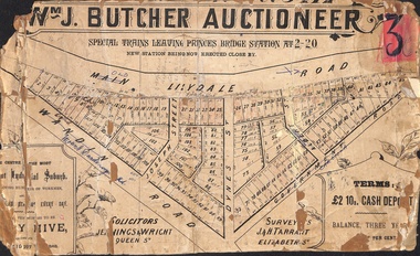
Poster - Land Sale, Wm J. Butcher, Auctioneer - Albert Park Estate, Ringwood - c.1890
... North melbourne Solicitors - Jenningw & Wright, Queen Street. Surveyors - J.&H. Tarrant, Elizabeth Street. Terms £2 10s cash deposit, balance three years at six per cent. Central section of land sale subdivision advertisement glued to heavy cardboard backing. Photocopied SLV image of original advertisement shows map of 117 allotments for sale in Main Lilydale Road (later Old Lilydale Road), Wandin Road (later Mount Dandenong ...Central section of land sale subdivision advertisement glued to heavy cardboard backing. Photocopied SLV image of original advertisement shows map of 117 allotments for sale in Main Lilydale Road (later Old Lilydale Road), Wandin Road (later Mount Dandenong Road), Joseph Street, Dynes Street, Albert Street (later Wyrunga Street) and Government Road (later Carcoola Road), Ringwood East.Solicitors - Jenningw & Wright, Queen Street. Surveyors - J.&H. Tarrant, Elizabeth Street. Terms £2 10s cash deposit, balance three years at six per cent. -
 Ringwood and District Historical Society
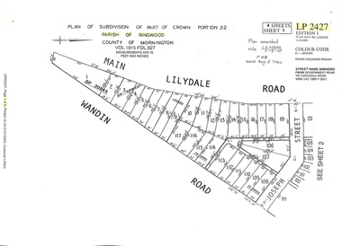
Document - Subdivision Map, Part of Crown Portion 22 Parish of Ringwood, County of Mornington. Vol 1915 Fol 827 - LP2427
... Ringwood and District Historical Society 125A Warrandyte Road Ringwood North melbourne Sheet 1 includes Main Lilydale Road (later Old Lilydale Road), Wandin Road (later Mount Dandenong Road), and Joseph Street, Ringwood East. ...LANDATA Land Victoria 4-sheet plan dated January 2003 - copy of original 1889 subdivision, amended with 1947 amendments by Assistant Registrar of Titles.Sheet 1 includes Main Lilydale Road (later Old Lilydale Road), Wandin Road (later Mount Dandenong Road), and Joseph Street, Ringwood East. Additional Plan markings SP30844, SP32804, LP144251, PS332061, PS305232. Sheet 2 includes Main Lilydale Road (later Old Lilydale Road), Wandin Road (later Mount Dandenong Road), and Dynes Street, Ringwood East. Additional Plan markings LP43708, LP44231, LP124702. Sheet 3 includes Main Lilydale Road (later Old Lilydale Road), Dynes Street, Albert Street (later Wyrunga Street), and Carcoola Road, Ringwood East. Additional Plan markings LP114181, LP114180, LP18261, LP214030, LP67300, PS354509, PS335500. Sheet 4 includes Main Lilydale Road (later Old Lilydale Road), Albert Street (later Wyrunga Street), and Carcoola Road, Ringwood East. Additional Plan markings PS315494, PS319495. -
 Ringwood and District Historical Society
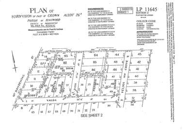
Document - Subdivision Plan, LP11645 Part of Crown Allotment 26A, Parish of Ringwood, County of Mornington Vol 5164 Fol 1032616 - 1926
... Ringwood and District Historical Society 125A Warrandyte Road Ringwood North melbourne Sheet 1 includes Mount Dandenong Road, Valda Avenue and Velma Grove, Ringwood East. ...LANDATA Land Victoria 2-sheet plan printout dated 2009Sheet 1 includes Mount Dandenong Road, Valda Avenue and Velma Grove, Ringwood East. Additional markings include SP35514, SP22189, SP34206, SP35514, SP26794, PS319109, PS319010 and PS304868. Sheet 2 includes Mount Dandenong Road, Valda Avenue, Mirabel Avenue and Velma Grove, Ringwood East. Additional markings include SP26430, SP25320, PS341575, PS319110, PS319010, LP48415, SP22732, SP25844, PS304936 and PS304937. -
 Ringwood and District Historical Society
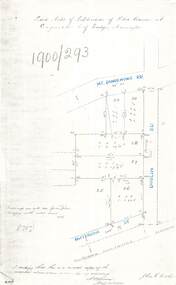
Document - Copy of Lands Department Field Notes - Subdivision of Police Reserve at Ringwood, County of Mornington, Field Notes 1900/293 - Part of O.P. R72C surveyed 1900
... Ringwood and District Historical Society 125A Warrandyte Road Ringwood North melbourne Foolscap size photocopy of survey map with handwritten notations. References include Mount Dandenong Road, Dublin Road, Patterson Street, Melbourne to Lilydale railway line, I certify that this is a correct copy of recorded observations made by my assistant (signed) W. ...Foolscap size photocopy of survey map with handwritten notations. References include Mount Dandenong Road, Dublin Road, Patterson Street, Melbourne to Lilydale railway line, I certify that this is a correct copy of recorded observations made by my assistant (signed) W. Thorn, Staff Surveyor. -
 Ringwood and District Historical Society
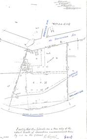
Document - Copy of Lands Department Field Notes - Subdivision of Ringwood, Victoria, Field Notes 1904/188 - Part of O.P. R72D Surveyed 28.4.1904
... Ringwood and District Historical Society 125A Warrandyte Road Ringwood North melbourne Foolscap size photocopy of survey map with handwritten notations. References include Mount Dandenong Road to Lilydale, M. ...Foolscap size photocopy of survey map with handwritten notations. References include Mount Dandenong Road to Lilydale, M. Dickson (sold), Church of England, P. Schonnenberger, Helen Lindsay, W.B. iron roof & shingles, I certify that this is a correct copy of the recorded observations and measurement made by me and my assistant (signed) W. Thorn 12/5/04 -
 Ringwood and District Historical Society
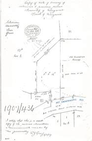
Document - Copy of Lands Department Field Notes - Survey of Extension to Recreation Reserve, Township of Ringwood, Victoria, Field Notes 1907/436 - Part of O.P. R72D Surveyed 6.8.1907
... Ringwood and District Historical Society 125A Warrandyte Road Ringwood North melbourne Foolscap size photocopy of survey map with handwritten notations. References include New Lilydale Road 3 chains wide (Mount Dandenong Road), Silurian, undulating, poor grass, Corner cut off to allow for road in future subdivision, Old recreation reserve, (circled area) oval now in use, A. ...Foolscap size photocopy of survey map with handwritten notations. References include New Lilydale Road 3 chains wide (Mount Dandenong Road), Silurian, undulating, poor grass, Corner cut off to allow for road in future subdivision, Old recreation reserve, (circled area) oval now in use, A. Gisler, I certify that this is a correct copy of the recorded observations & measurements made by me personally (signed) R.J. Gray 6/8/07. -
 Ringwood and District Historical Society
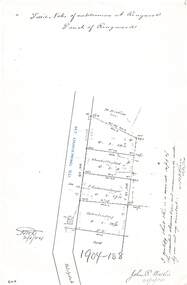
Document - Copy of Lands Department Field Notes - Parish of Ringwood, Victoria, Field Notes 1909/174 - Part of O.P. R72D surveyed 12.3.1909
... Ringwood and District Historical Society 125A Warrandyte Road Ringwood North melbourne Foolscap size photocopy of survey map with handwritten notations. References include Mount Dandenong Road, pathway, 2 room house, scillion, shed, WC, 17C sold, Cr lands, orchard, 17E sold, Township boundary, I certify that these field notes are a true copy of the actual results of observations and measurements taken by me on the ground (signed) D. ...Foolscap size photocopy of survey map with handwritten notations. References include Mount Dandenong Road, pathway, 2 room house, scillion, shed, WC, 17C sold, Cr lands, orchard, 17E sold, Township boundary, I certify that these field notes are a true copy of the actual results of observations and measurements taken by me on the ground (signed) D. Barker 12.3.09. -
 Ringwood and District Historical Society
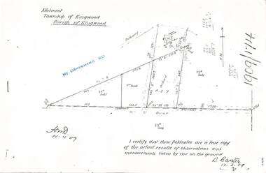
Document - Copy of Lands Department Field Notes - Parish of Ringwood, Victoria, Field Notes - OP34838 - surveyed in 1919 by D. Barker
... Ringwood and District Historical Society 125A Warrandyte Road Ringwood North melbourne 5615b Foolscap size photocopy of survey map with handwritten notations. References include Braeside Avenue, Mount Dandenong Road, Rosedale Court, Railway Avenue, cyclone fence, Sec A, WB house, old tennis court netted, stable, old shed, tank stand, orchard, Township Boundary, netting fence, Railway fence, Ringwood to Lilydale Railway, I certify that these fieldnotes are a true copy of the actual results of observations & measurements taken by me on the ground (signed) D. ...5615b Foolscap size photocopy of survey map with handwritten notations. References include Braeside Avenue, Mount Dandenong Road, Rosedale Court, Railway Avenue, cyclone fence, Sec A, WB house, old tennis court netted, stable, old shed, tank stand, orchard, Township Boundary, netting fence, Railway fence, Ringwood to Lilydale Railway, I certify that these fieldnotes are a true copy of the actual results of observations & measurements taken by me on the ground (signed) D. Barker (1919). -
 Ringwood and District Historical Society
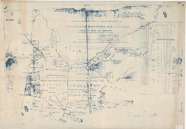
Map, Plan of Country Lands in the Parishes of Nunawading Ringwood and Scoresby - circa 1855
... North melbourne "Surveyed and plotted by N.M. Bickford, Superintendant of Mr. Hodgkinson's Field Party". "The land comprised in this survey is of inferior quality, moderately undulating, and thickly wooded. It is watered by Dandenong Creek and Deep Creek." Inset map showing location of (*proposed) cemetery on southern corner of Lillydale Road from Melbourne and Sawmill Road, later Mount ...Blueprint copy of Survey Map detailing original Selectors' names and property locations. List of Parish map references including property bearings, distances in Links, and markings on trees. Descriptive remarks include areas marked "Farmer's Common", "Poor soil thickly/moderately timbered with stringy bark", and location of water and firewood reserves."Surveyed and plotted by N.M. Bickford, Superintendant of Mr. Hodgkinson's Field Party". "The land comprised in this survey is of inferior quality, moderately undulating, and thickly wooded. It is watered by Dandenong Creek and Deep Creek." Inset map showing location of (*proposed) cemetery on southern corner of Lillydale Road from Melbourne and Sawmill Road, later Mount Dandenong Road. (*Cemetery did not eventuate.) -
 Ringwood and District Historical Society
Legal record - Fire Insurance document (C.E.Carter), Fire Insurance - Commercial Union Assurance Co Ltd for Charles W Bruce, 1943
... Ringwood and District Historical Society 125A Warrandyte Road Ringwood North melbourne Policy issued to Charles W. Bruce, for dwelling in Mount Dandenong Road, Ringwood. ...Standard form of Fire Insurance Policy issued by Commercial Union Assurance Co LtdPolicy issued to Charles W. Bruce, for dwelling in Mount Dandenong Road, Ringwood. -
 Ringwood and District Historical Society
Photograph - Newspaper Clipping, Early View of Club Hotel, Ringwood East
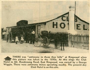
... The Club Hotel featured in the article was located on the north side of Mount Dandenong Road. It was destroyed by fire in 1890 prior to re-opening later on the south side where it operated until sale and demolition in 2020 to make way for a retirement village. ...The Club Hotel featured in the article was located on the north side of Mount Dandenong Road. It was destroyed by fire in 1890 prior to re-opening later on the south side where it operated until sale and demolition in 2020 to make way for a retirement village. ...The newspaper clipping caption is incorrect. The Club Hotel featured in the article was located on the north side of Mount Dandenong Road. It was destroyed by fire in 1890 prior to re-opening later on the south side where it operated until sale and demolition in 2020 to make way for a retirement village. (See PDF attached - "SS0067 Vic Collections 3754b - Club Hotel Fire 1890").Early View of Club Hotel, Ringwood East. Weatherboard with iron roof. Single chimney on one end. Picket fence on RHS. Two horse-drawn vehicles standing out front including three adults and two children. Source/date of newspaper unknown. Later newspaper item also attached reporting hotel being destroyed by fire in 1890.Caption: There was 'antimony in them thar hills' at Ringwood when this picture was taken in the 1890s. At that time the Club Hotel in Mt Dandenong Road, East Ringwood was owned by a George Wiggin. There were antimony mines operating nearby. The present-day Club Hotel is on this site. -
 Ringwood and District Historical Society
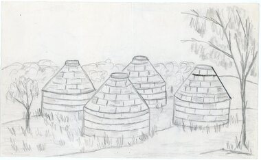
Work on paper - Pencil sketch, Artist unknown, initials D.M, Sketch of pottery kilns at East Ringwood, corner of Velma Grove and Mount Dandenong Road (Oxford Road). Kilns shut down in 1926, c.1926
... North melbourne Kilns; D.M. Sketch of the four pottery kilns at East Ringwood, corner of Velma Grove and Mount Dandenong Road (Oxford Road). ...Sketch of the four pottery kilns at East Ringwood, corner of Velma Grove and Mount Dandenong Road (Oxford Road). The kilns shut down in 1926. Judging by the handwriting, the artist and author appears to be John Rodaughan, East Ringwood historian, whose other works include history on Burnt Bridge Hotel and other parts of East Ringwood. The back of the sketch includes a rough hand-drawn map, that appears to be of the insulator works area, between Mt Dandenong Road and Evon Avenue. The timeline includes generic milestones in blue ink and those associated with Ringwood in red writing.Kilns; D.M. -
 Ringwood and District Historical Society
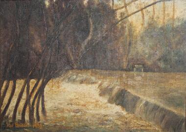
Painting, "Busch's Weir" - Oil on canvas by Hermann Otto ("Hof") Busch (1880-1960), 1953
... Ringwood and District Historical Society 125A Warrandyte Road Ringwood North melbourne In the 1930s, Hermann Busch constructed a concrete wall across Dandenong Creek, forming "Busch's Weir" on his Bayswater property, "Waldheim". The weir wall was demolished in the 1960s. Hof Busch 1953 One of two paintings of weir across Dandenong Creek, mounted ...In the 1930s, Hermann Busch constructed a concrete wall across Dandenong Creek, forming "Busch's Weir" on his Bayswater property, "Waldheim". The weir wall was demolished in the 1960s.One of two paintings of weir across Dandenong Creek, mounted in beveled edge wooden frame with ornate corner moldings. (See Reg #4856B for other of two paintings in the pair)Hof Busch 1953 -
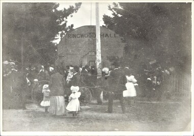 Ringwood and District Historical Society
Photograph, Ringwood Hall, Mount Dandenong Road, Ringwood - circa 1900, Circa 1900
... Ringwood and District Historical Society 125A Warrandyte Road Ringwood North melbourne Ringwood Hall was located near the Club Hotel in Mount Dandenong Road prior to construction of Mechanics Institute/Town Hall in Maroondah Highway in 1909. ...Ringwood Hall was located near the Club Hotel in Mount Dandenong Road prior to construction of Mechanics Institute/Town Hall in Maroondah Highway in 1909.Black & white photo of crowd gathered at original Ringwood Hall, Mount Dandenong Road, Ringwood. "Old Ringwood Hall nr. Club Hotel, later burnt down approx 1909". "Old Ringwood Hall prior to Mech Inst of 1909".