Showing 52 items matching moyne shire
-
 Ballarat Heritage Services
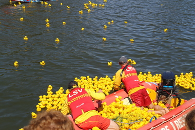
Digital photographs, L.J. Gervasoni, Moyneyana Ducks, c2013
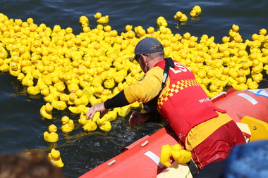
... Moyne River, Port Fairy, Moyne Shire, Victoria, Australia ...Each new year's day there is a duck race at Port Fairy on the Moyne River. Colour photograph of rubber ducks in the Moyne River on new year's day. landscape, river, moyneyana, duck race, fundraiser, slsc, surf life saving club, port fairy, rubber ducks, moyne river -
 Ballarat Heritage Services
Digital photographs, L.J. Gervasoni, Moyneyana ducks, c2013
... Moyne River, Port Fairy, Moyne Shire, Victoria, Australia ...landscape, river, moyneyana, duck race, fundraiser, slsc, surf life saving club, port fairy, rubber ducks, moyne river -
 Ballarat Heritage Services
Digital photographs, L.J. Gervasoni, Underwater Scene at Pea Soup Beach, Port Fairy, c2013
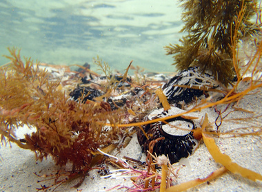
... Pea Soup, Port Fairy, Moyne Shire, Victoria, Australia ...Underwater photograph showing seaweed.landscape, port fairy, beach, pea soup beach, sand, kelp, seaweed, seascape, waterscape, underwater -
 Ballarat Heritage Services
Digital photographs, L.J. Gervasoni, Underwater Scene at Pea Soup Beach, Port Fairy, c2013
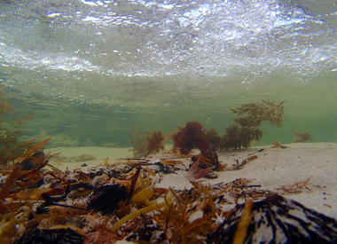
... Pea Soup, Port Fairy, Moyne Shire, Victoria, Australia ...Colour underwater photograph of seaweed.landscape, port fairy, beach, pea soup beach, sand, kelp, seaweed, seascape, waterscape, underwater -
 Ballarat Heritage Services
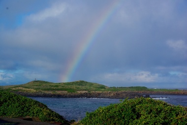
Digital photographs, L.J. Gervasoni, Griffith Island, Port Fairy, c2013
... Griffith Island, Port Fairy, Moyne Shire, Victoria ...Colour photograph of Griffiths Island. landscape, port fairy, beach, waterscape, moyne river, griffith island, rainbow, weather -
 Ballarat Heritage Services
Digital photographs, L.J. Gervasoni, getting the ducks back in the boat, c2013
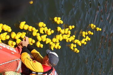
... Moyne River, Port Fairy, Moyne Shire, Victoria, Australia ...Colour photograph of the Duck Race on teh Moyne River held on New Year's Day at Port Fairy. landscape, port fairy, beach, waterscape, moyne river, moyneyana, new years day, duck race -
 Ballarat Heritage Services
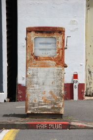
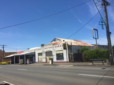
Photograph - Digital photographs, L.J. Gervasoni, Koroit Garage, 2015
... Commercial Road, Koroit, Moyne Shire, Victoria, Australia ...An old garage in Koroit.Digital images of a petrol bowser in Koroit, Victoria. bowser, fuel, pump, garage, motor, motor garage, mechanics, petrol bowser, petrol station -
 Ballarat Heritage Services
Photograph - Digital photographs, L.J. Gervasoni, Koroit Garage, 2017, 2015
... Commercial Road, Koroit, Moyne Shire, Victoria, Australia ...An old garage in Koroit.Digital images of a petrol bowser in Koroit, Victoria. bowser, fuel, pump, garage, motor, motor garage, mechanics, petrol bowser, petrol station -
 Ballarat Heritage Services
Photograph - Digital photographs, L.J. Gervasoni, Kathleen Gervasoni at former Carleton Inn, Killarney, Victoria, 2015
... Princes Highway, Killarney, Moyne Shire, VIC, Australia ...Michael O'Dea, who built the Carleton Inn, was a member for the Belfast Road Board. Digital images of Kathleen Gervasoni at Carleton Inn, Killarney. She is the Great Grandaughter of Michael O'Dea who built the Inn.kathleen carroll, carleton inn, killarney, victoria, michael o'dea -
 Federation University Historical Collection
Book, Toni Woolley et al, Port Fairy Community and Organisational Plan, 1999
... moyne shire council... analysis of services and service quality moyne shire council ...Port Fairy Community and Organisational Plan. University of Ballarat Students' Project.White bound book of 35 pages plus 6 appendices.port fairy, toni woolley, tamara lang, janelle gilbert, ben balshaw, grant caromody, executive summary, introduction, background to port fairy, methodology, limitations, appraisal of tourism planning and development to date, assessment of local community issues, attitudes and involvement in tourism, roles of local and regional tourism associations, effectiveness of local & regional tourism associations, analysis of services and service quality, moyne shire council, friends of port fairy, tourism victoria, country victoria tourism, great ocean road marketing, shipwreck coast tourism, port fairy tourism association inc, moyne shire, department of natural resources and environment, the western coastal board, tourism accreditation board of victoria, george borg, craig delahoy, michael hearn, jodie honan, judith kershaw, andrea lowenthal, neil martin, john ploenges, james purcell, peter strickland, mark thompson, libby wilson, michael pearlman, battle of the moyne, tourism planning, great ocean road -
 Peterborough History Group
Booklet - 1934 Western District Centenary Magazine, Terang Express, Western District Centenary Souvenir, 1934
... moyne shire.... Sold for ? in Barry Jenkins General Store moyne shire ..."The Western District Centenary Souviner"Published in 1934 as an anniversary edition for Edward Henty making his historic landing on the shores of Portland Bay on November 19, 1834Has tourism and business advertisements for Peterborough businesses. Refers to families and and early settlers of Peterborough. Sold for ? in Barry Jenkins General StoreA magazine shaped booklet. Cover replaced with wall paper and bound with tape and string. Forward stuck to front cover. Browned with age and taped on a few pagesWholly set up, Printed and Published at THE TERANG EXPRESS""Office, Terangmoyne shire, peterborough 3270, western district souvenir, peterborough general store, london bridge, great ocean road -
 Peterborough History Group
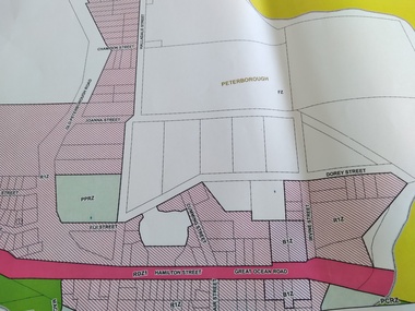
Map - Peterborough Planning Map
... moyne shire zoning map... of Peterborough peterborough town planning maps moyne shire zoning map ...Planning information as at 2012Showing the changing face of PeterboroughA3 size printed copies (2) of planning, environmental and other overlays for the town of Peterborough in 2012peterborough, town planning, maps, moyne shire zoning map -
 Ballarat Heritage Services
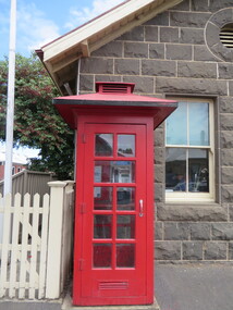
Photograph - Photograph - Colour, Clare Gervasoni, Koroit Post Office, 2015, 21/12/2015
... Mason of Port Fairy. (Moyne Shire Heritage Study 2006 Stage 2... Mason of Port Fairy. (Moyne Shire Heritage Study 2006 Stage 2 ...The town borrows its name from the Koroitch Gundidj people who occupied the area prior to European settlement. (https://en.wikipedia.org/wiki/Koroit, accessed 21 December 2016) Koroit was first surveyed as a township in 1847. Around the 1850 the district had the highest population of Irish immigrants in rural Australia. The Koroit Post Office was designed by architect and engineer John Mason of Port Fairy. (Moyne Shire Heritage Study 2006 Stage 2, Volume 2: Environmental History, Prepared for Moyne Shire Council Helen Doyle in association with Context Pty Ltd, 2006.) Rosebrook Bridge, Rosebrook (1853; replaced) Post Office buildings, Bank Street, Port Fairy (c.1857) The author Henry Handel Richardson lived in the Koroit Post Office as a child after her family moved to Koroit in 1878. Remembering Koroit from her youth, the third volume in her The Fortunes of Richard Mahony trilogy is set in the town. When the author was six, her father Walter died in Koroit on 1 August 1879 and was buried at the Koroit cemetery. (https://en.wikipedia.org/wiki/Koroit, accessed 21 December 2016) In 1878 Mary Richardson was appointed postmistress of the Koroit Post Office at a salary of 72 pounds with free quarters, firewood and kerosene. She lived at the back of the Post Office. (From a Green and Pleasant Land by H. McCorkell and P. Yule.) Photographs showing the bluestone Koroit Post Office, phone box and postbox. It is located at 99 Commercial Road, Koroit. "Historic Area Statement of Significance: The significance of Koroit derives from its role as the urban centre of one of the most concentrated Irish Roman Catholic rural districts in Australia, noted for its mixed livestock and cropping argicultural patterns. This is reflected in two separate and distinctive areas in the town - the administrative/commercial area and the church precinct. The administrative and commercial area (focussing on the Boundary-Commercial Road/High Street intersection and the Koroit Hotel) consists of a number of significant public buildings and leads to a street of relatively intact humble shopfronts and kerbline verandahs, visually punctuated by opposing bank facades. The church precinct is dominated by a group of Catholic buildings larger in scale and more complete in range than those in any comparably sized Victorian town." http://vhd.heritagecouncil.vic.gov.au/places/69338#sthash.ELLuSMvg.dpuf, accessed 21 December 2016."koroit, post office, phone box, payphone, bluestone, henry handel richardson, koroit post office -
 Warrnambool and District Historical Society Inc.
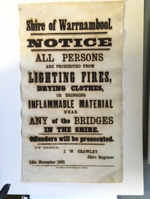
Document, Shire of Warrnambool Fire - Washing-Bridge 1882, 1882
... into the Moyne Shire in the 1990's with some being included... of it was incorporated into the Moyne Shire in the 1990's with some being ...This notice relates to the prohibition of lighting fires,drying clothes or bringing inflamable material near any of the bridges in the shire. Offenders will be prosecuted. With a date of 1882 and the fact that bridges were mostly made of wood, it would have been of concern that the destruction of bridges was not only of great inconvenience but also of considerable expense. But the reality of bridges providing shelter and warmth in the colder months and the ensuring fires and burnt bridges has more than likely precipitated this notice. J W Crawley was shire engineer from 1876 until 1895 and for 10 of those years he trained his son J W Crawley who succeeded his father and served in the position for 40 years.He in turn was succeeded by his son Rolf Crawley in 1935. In 1963 the bridge over the Hopkins Falls at Wangoom was named the Crawley bridge in honour of service to the Shire of Warrnambool by members of the Crawley family. The Shire of Warrnambool was proclaimed in 1863 and covered an area of over 600 square miles. Much of it was incorporated into the Moyne Shire in the 1990's with some being included into the boundaries of City of Warrnambool. This banner is an interesting piece of history. It shows the issues confronting early settlers such as shelter and the chores of daily life but also the importance placed on infrastructure which was slowly taking place around the district. It was in the era of drainage and roadworks and hence bridges were an important part of that infrastructure. The name J W Crawley is one of importance in the Warrnambool district for his service over many years. Rectangular piece of cloth printed in black ink. The back is plain.Shire of Warrnambool By order of J W Crawley Shire Engineer, 13th November 1882. Thos Smith gas Printing Works Koroit Street Warrnambool.warrnambool, shire of warrnambool, bridges of warrnambool shire, j w crawley, warrnambool shire engineer, crawleys of warrnambool -
 Warrnambool and District Historical Society Inc.
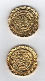
Medallions, Borough of Koroit, 1985
... into the Shire of Warrnambool as the Koroit Riding. In 1994 the Shire... part of the Shire of Moyne. These medals are interesting ...These medals were produced in 1985 to denote the closing of the Koroit Borough. Koroit is 18 kilometres north west of Warrnambool and the Borough of Koroit, established in 1870, covered 23.07 square kilometres. In 1985 the Borough of Koroit was incorporated into the Shire of Warrnambool as the Koroit Riding. In 1994 the Shire of Warrnambool ceased to exist and Koroit became part of the Shire of Moyne.These medals are interesting mementoes of the Borough of Koroit, a municipal authority that no longer exists.These identical gold coloured metal, almost circular, medallions feature a coat of arms with indistinguishable text and emblems , a second text and a wreath of laurel around the rim. The edge is notched and indented at the base.. The reverse side has text on a circular centre with the back of the laurel wreath surrounding it. Obverse BOROUGH OF KOROIT1870 Reverse 1870 1985koroit borough, warrnambool history -
 Warrnambool and District Historical Society Inc.
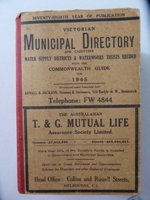
Stamp, W'bool Co.op Commons Seal, 1945
... shires to form the present day Shire of Moyne. ... shires to form the present day Shire of Moyne. This book is very ...This is a Victorian Municipal Directory for 1945, containing general information on all municipalities in Victoria, a Gazeteer, a Commonwealth Guide and a Water Supply Record. Municipal Directories were published annually in Victoria from 1867 on. This directory came from the Shire of Mortlake which was established in 1864 when it had an area of 2137 square kilometres. The Shire of Mortlake was abolished in 1994 and merged with other neighbouring shires to form the present day Shire of Moyne. This book is very useful to researchers as it contains much information on the City, Borough and Shire structures, the Council employees and Government employees of all the municipalities. It has, therefore, important local information on Warrnambool and the surrounding areas in 1945. This is a soft cover book of 1114 pages. It has a buff- coloured cover with red binding on the spine. The printed material on the covers is printed in black. It has a blue stamp of the Shire of Mortlake on several pages. The book contains several advertisements for Melbourne businesses. ‘Shire of Mortlake’ shire of mortlake, local government in victoria, warrnambool history -
 Warrnambool and District Historical Society Inc.
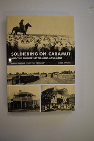
Book, StarPrinting Service Pty ltd, Soldiering On – Caramut and the Soldier Settler Movement, 2018
... in Western Victoria in the Shire of Moyne on the Hamilton Highway, 55... in the Shire of Moyne on the Hamilton Highway, 55 kilometres north ...This book records the history of the post World War Two soldier settlement farms in the Caramut area. Number two in a series of books on Soldier Settlements in Western Victoria.This is a soft cover book of 315 pages. It has a buff-coloured cover with black and white photographs and white printing on the front cover and black printing on the spine. The book includes printed material, black and white photographs, maps and plans. non-fiction This book records the history of the post World War Two soldier settlement farms in the Caramut area. Number two in a series of books on Soldier Settlements in Western Victoria.james affleck, peterborough, soldier settlement, caramut, history of warrnambool, soldier settlement, caramut -
 Warrnambool and District Historical Society Inc.
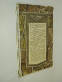
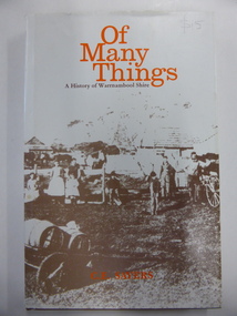
Book, Of Many Things, 1987
... into the Shire of Moyne. ... into the Shire of Moyne. This book is the official history of the Shire ...This book is the official history of the Shire of Warrnambool from 1863 to 1987. It was written by C.E. Sayers for the Shire of Warrnambool. Sayers also wrote the history of Warrnambool called By These We Flourish for the Warrnambool City Council. The Shire of Warrnambool was established in 1863 and the first meeting was held in January 1864. In 1992 the Shire covered an area of 1605 square kilometres and had a population of 8,940 and included the areas around Koroit, Allansford, Peterborough, Port Fairy and Nirranda. The Shire of Warrnambool was abolished in 1994 and was incorporated with other municipalities into the Shire of Moyne. This book is the official history of the Shire of Warrnambool and this copy is kept for future reference when the book is superseded or out of print. This is a hard cover book of 196 pages. It has a brown cover with gold lettering on the spine. The dust cover has a white background with an image on the front cover in brown and grey tonings of a rural property in the Shire of Warrnambool. The lettering on the dust cover is orange on the front cover and black on the spine. The book has a foreword, an introduction, 14 chapters of text, appendices and an index. There are many black and white photographs.shire of warrnambool, history of warrnambool, of many things -
 Port Fairy Historical Society Museum and Archives
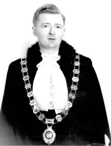
Photograph, Brophy, John Sarsfield Mayor of Borough of Port Fairy 1956 1957 1975 1976 1977 1978
John Sarsfield Brophy Mayor 1956 1957 1975 1976 1977 1978 CEO of Port Fairy Hospital Greatly involved in the Moyneyana Festival which raises money for the Port Fairy Hospital or Moyne Health Services as it is now known.Black & white portrait of John Brophy in mayoral robes, jabot and gold chainbelfast, mayor, portrait, government, shire, council, municipal, local-government -
 Port Fairy Historical Society Museum and Archives
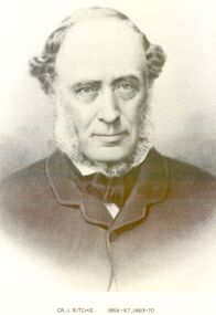
Photograph, Cr J Ritchie Shire of Belfast President1866-67 1869-70
Cr J Ritchie came from Scotland at Hobart in 1833 having been 9 months on the outward journey. he took up land at South Esk and remained there for 6 years.later on advice of the Henry brothers he came to Victoria and after a preliminary inspection of the land charted the brig “William” and with all of his possessions, including 2000 sheep and two servants he arrived in Portland Bay in January 1840 and as he already held a squatting licence No 230 became a settler in the district. he moved along the coast toward Goose Lagoon but due to a drought the water had dried up and forced him to move further eastward to the Upeer Hopkins but the lack of any but brackish water he was forced to return to Aringa. Aringa comprised of 26,000 acres between the Shaw and Moyne Rivers, 640 acres became freehold at one pound and acre with the right to take up leasehold at a low rate according to the number of stock. At Aringa he designed and built his first home part of which still stands today. He married Sarah Elizabeth Davis in 1852 at Weerongurt Station (Mr John Cox’s property). Mrs Ritchie died in 1920. he was elected Shire of Belfast President for the periods of 1866-67 and 1869-70 John had originally chosen to practice law as his vocation in Scotland but abandoned law for the open air life and died at the age of 86 years in 1887 elected Shire of Belfast President for the periods of 1866-67 and 1869-70Black and white portrait photograph Cr J Ritchie 1866-67 1869-70belfast, president, council, portrait, government, shire, municipal, local-government -
Glenelg Shire Council Cultural Collection
Map - Map - RACV Road Map, 1970s
RACV road map, Portland district, Port MacDonnell to Warrnambool. Large coloured map of Portland District, small maps of Portland, Mt Gambier, Hamilton, Mount Eccles National Park, Coonawarra Wineries. When folded, black and white phot of child fishing on jetty on Moyne River, Port Fairy on coverroad touring, racv, map -
Glenelg Shire Council Cultural Collection
Functional object - Lifebuoy, n.d
City of Portland Collection|Kurtze Museum|19/4/2000. The lifebuoy came from the S S Casino. A popular cargo ship, the Casino was a regular sight on the Moyne river and along the coast. The ship was an integral part of coastal life until she was shipwrecked in the 1930's, and objects from the Casino can now be found in collections from across the region.S S CasinoCanvas covered ring of bouyant material (possibly cork), with rope loop fixed to 4 ponts on the outside edge. Inscription "S.S. CASINO" centre top, "PORT FAIRY" at centre bottom, a flag painted centre left and centre right.Front: Centre top "S. S. CASINO"|Centre bottom "PORT FAIRY"|flag on centre left and centre rightss casino, port fairy, cargo ship, lifebuoy