Showing 95 items matching "mt william road"
-
 Halls Gap & Grampians Historical Society
Photograph - B/W
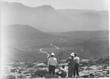
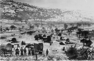
... ...Mt William Road...Photo shows construction workers looking over valley with rough formation of Mt William road. There are 4 men in photo, 2 wearing hard-hats. ...Halls Gap & Grampians Historical Society Centennial Hall 117-119 Grampians Road Halls Gap grampians ACCESS ROUTES Roads ACCESS ROUTES Mt William Road WMT Mt William construction 1966-68 Photo shows construction workers looking over valley with rough formation of Mt William road. ...Photo shows construction workers looking over valley with rough formation of Mt William road. There are 4 men in photo, 2 wearing hard-hats. There appears to be 2 vehicles on the road.WMT Mt William construction 1966-68access routes, roads, access routes, mt william road -
 Halls Gap & Grampians Historical Society
Photograph - B/W, C 1960s (?)
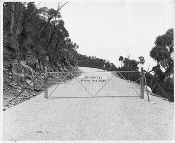
... A photo of the gate barring vehicle access to the top portion of the Mt William Road. The photo is part of a Ministry of Tourism campaign....The photo shows an iron gate across a road (Mt William Road). There is a man standing on the edge of the road in the background. ...Halls Gap & Grampians Historical Society Centennial Hall 117-119 Grampians Road Halls Gap grampians A photo of the gate barring vehicle access to the top portion of the Mt William Road. The photo is part of a Ministry of Tourism campaign. ...A photo of the gate barring vehicle access to the top portion of the Mt William Road. The photo is part of a Ministry of Tourism campaign.The photo shows an iron gate across a road (Mt William Road). There is a man standing on the edge of the road in the background. A sign on the gate reads 'No vehicles beyond this point'.'Ministry of Tourism of Victoria, 276 Collins St., Melbourne, Nag. No.... , Date ..., Locality Grampians, Subject Gate-Mount William Road.' stamped on back.access routes, roads, scenery, mount william -
 Halls Gap & Grampians Historical Society
Photograph - B/W
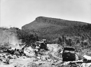
... ...Mt William Road...Photo shows men & machinery forming the road up Mt William. There are 8 men, 1 bull-dozer, 1 jeep...Halls Gap & Grampians Historical Society Centennial Hall 117-119 Grampians Road Halls Gap grampians ACCESS ROUTES Roads ACCESS ROUTES Mt William Road Photo shows men & machinery forming the road up Mt William. ...Photo shows men & machinery forming the road up Mt William. There are 8 men, 1 bull-dozer, 1 jeepaccess routes, roads, access routes, mt william road -
 Halls Gap & Grampians Historical Society
Photograph - B/W
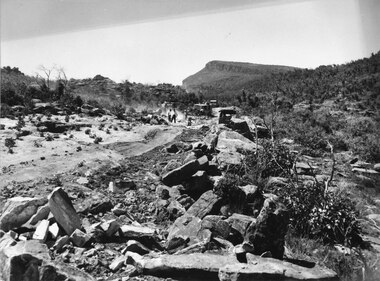
... ...Mt William Road...Photo shows men & machines on construction work for road to Mt William...Halls Gap & Grampians Historical Society Centennial Hall 117-119 Grampians Road Halls Gap grampians ACCESS ROUTES Roads ACCESS ROUTES Mt William Road Photo shows men & machines on construction work for road to Mt William Photograph B/W ...Photo shows men & machines on construction work for road to Mt Williamaccess routes, roads, access routes, mt william road -
 Halls Gap & Grampians Historical Society
Photograph - B/W
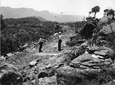
... ...Mt William Road...Photo shows 2 men standing on rough formation of road to Mt William. One man is wearing a hard-hat, the other a felt hat....Halls Gap & Grampians Historical Society Centennial Hall 117-119 Grampians Road Halls Gap grampians ACCESS ROUTES Roads ACCESS ROUTES Mt William Road Photo shows 2 men standing on rough formation of road to Mt William. ...Photo shows 2 men standing on rough formation of road to Mt William. One man is wearing a hard-hat, the other a felt hat.access routes, roads, access routes, mt william road -
 Halls Gap & Grampians Historical Society
Photograph - B/W
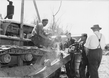
... ...Mt William Road...Halls Gap & Grampians Historical Society Centennial Hall 117-119 Grampians Road Halls Gap grampians ACCESS ROUTES Roads ACCESS ROUTES Mt William Road Photo shows 5 men surrounding bulldozer. ...Photo shows 5 men surrounding bulldozer. One is looking straight at camera, another is u;sing welding equipment.access routes, roads, access routes, mt william road -
 Halls Gap & Grampians Historical Society
Photograph - B/W
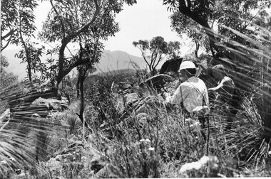
... ...Mt William Road...Halls Gap & Grampians Historical Society Centennial Hall 117-119 Grampians Road Halls Gap grampians ACCESS ROUTES Roads ACCESS ROUTES Mt William Road Photo shows construction workers taking a break. ...Photo shows construction workers taking a break. Men are seated, surrounded by thick bush & flowers.access routes, roads, access routes, mt william road -
 Halls Gap & Grampians Historical Society
Photograph - B/W, C 1960s
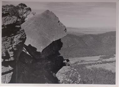
... The Fyans Valley is below with the Mt. William range behind it. Roads traverse the valley. Some buildings can be seen....Halls Gap & Grampians Historical Society Centennial Hall 117-119 Grampians Road Halls Gap grampians Slab of rock is known as the The Fallen Giant SCENERY Wonderland Range Photo shows large slab of rock with other rock outcrops. The Fyans Valley is below with the Mt. William ...Slab of rock is known as the The Fallen GiantPhoto shows large slab of rock with other rock outcrops. The Fyans Valley is below with the Mt. William range behind it. Roads traverse the valley. Some buildings can be seen.scenery, wonderland range -
 Federation University Historical Collection
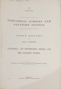
Booklet - Report, John Ferres, Government Printer, Royal Commission on Industrial and Reformatory Schools and the Sanatory Station, 1872 and 1874
... Mt Helen Campus Federation University Australia E.J. Barker Library (top floor) Mount Helen goldfields The Industrial Schools and Quarantine Station Royal Commission took place in 1872, with the final report published in 1874. quarantine industrial schools reformatory schools royal commission gavin duffy st kilda road industrial school industrial schools commission red hill philanthropic school flat islands port phillip bay pauper children johanna margaret hill american industrial schools cuthbert fox james walker pilot schooner rip captain h.h. o'neil william mccrae t.m. girdlestone william austin zeal j.a. panton Industrial Schools and Quarantine Station Royal Commission Quarantine Station Point Nepean Sanatory Station Queenscliff Point nepean philanthropic school red hill rip George Ferguson Bowen orphan asylums On front cover "From Tom Evans MLA" .1) First report of the Royal Commission on Industrial and Reformatory Schools and the Sanatory Station. 65 pages. .2) Second and final report of the Royal Commission on Industrial and Reformatory Schools and the Sanatory Station. 16 pages. ...The Industrial Schools and Quarantine Station Royal Commission took place in 1872, with the final report published in 1874..1) First report of the Royal Commission on Industrial and Reformatory Schools and the Sanatory Station. 65 pages. .2) Second and final report of the Royal Commission on Industrial and Reformatory Schools and the Sanatory Station. 16 pages. This report included defects in the system and recomendations.On front cover "From Tom Evans MLA"quarantine, industrial schools, reformatory schools, royal commission, gavin duffy, st kilda road industrial school, industrial schools commission, red hill philanthropic school, flat islands port phillip bay, pauper children, johanna margaret hill, american industrial schools, cuthbert fox, james walker, pilot schooner rip, captain h.h. o'neil, william mccrae, t.m. girdlestone, william austin zeal, j.a. panton, industrial schools and quarantine station royal commission, quarantine station point nepean, sanatory station, queenscliff, point nepean, philanthropic school red hill, rip, george ferguson bowen, orphan asylums -
 Federation University Historical Collection
Booklet, Eyres Brothers Centenary
... Mt Helen Campus Federation University Australia E.J. Barker Library (top floor) Mount Helen goldfields Eyres brothers edward newman william eyres thomas eyres 16 page booklet with blue and grey cover. It covers information Eyres Brothers between 1855 and 1955, and their Man Road ...16 page booklet with blue and grey cover. It covers information Eyres Brothers between 1855 and 1955, and their Man Road business "Eyres Brothers and Newman'. THe publication includes illustrations. eyres brothers, edward newman, william eyres, thomas eyres -
 Eltham District Historical Society Inc
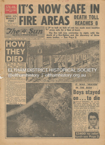
Newspaper - Newspaper articles, Sun News-Pictorial, It's Now Safe in Fire Areas; Death Toll Reacxhes 8, The Sun News-Pictorial, Thursday, January 18, p1, 1962
... William Ockwell...Leslie Ockwell...Linda May Ockwell...Black Friday...Victorian Bushfires – 1939...Warrandyte...Arthur Brown...Harold Vernon Betton...Bloom Road...William Smith...Olinda...Bushfire Relief Fund...Yarra Glen...Healesville...Railway Line...St. Andrews...Smith’s Gully...Otway Ranges...Eric Watts...Edith Varty...Inverness Road...Mt...Tom Fielding Collection Victorian Bushfires - 1962 Victorian Bushfires – 1962 Ronald Ockwell Geoffrey Ockwell Woori Yallock William Ockwell Leslie Ockwell Linda May Ockwell Black Friday Victorian Bushfires – 1939 Warrandyte Arthur Brown Harold Vernon Betton Bloom Road William Smith Olinda Bushfire Relief Fund Yarra Glen Healesville Railway Line St. Andrews Smith’s Gully Otway Ranges Eric Watts Edith Varty Inverness Road Mt ...Various news articles pertaining to the January 1962 Victorian bushfires in the Dandenong and Healesville districts which by the third day had encompassed large areas of the State. Specific Eltham Shire districts mentioned include Warrandyte on page 1, St. Andrews and Smith’s Gully on page 2, St. Andrews on page 3 and 43, Panton Hill and Warrandyte on p23 and Hurstbridge on page 44 • It's Now Safe in Fire Areas; Death Toll Reaches 8, p1 (Illust.) • How they died, pp1-2 • It was “heaven” in the bush … Boys stayed on . . . to die, pp1-2 (Illust.) • Towns take stock as danger drops, p2 • £5400 to the relief fund, p2 • Fire now threat to Otways, p2 • Pensioners lose all, p2 • “…If Only The Rain Had Come” … and then it came to town, p3 (Illust.) • Our best rain since May • It halted at Grandma’s front gate, p5 (Illust.) • Now that the rain has come; It’s time for the clean-up, p6 • Wisps of smoke where flames danced, p7 • Charitry’s a loser, p7 • War Service homes claim, p7 • Help’s on way, p7 (Illust.) • Came with their gifts …, p7 • Fire summons for youth; “sparked the rest”, p9 • Three gaoled, p9 • They had to camp out at Wye River, p9 (Illust.) • “Probe Fires” – Stoneham, p9 • The Fourth Day: Scorched Earth!, pp22-23 (Illust.) • This home was saved but - , p22 (Illust.) • Relief Centre, p23 (Illust.) • Homeless, p23 (Illust.) • So little was left, p43 (Illust.) • Tommy saved his cat, p43 (Illust.) • Some were lucky … and some were tired, p44 (Illust.) tom fielding collection, victorian bushfires - 1962, victorian bushfires – 1962, ronald ockwell, geoffrey ockwell, woori yallock, william ockwell, leslie ockwell, linda may ockwell, black friday, victorian bushfires – 1939, warrandyte, arthur brown, harold vernon betton, bloom road, william smith, olinda, bushfire relief fund, yarra glen, healesville, railway line, st. andrews, smith’s gully, otway ranges, eric watts, edith varty, inverness road, mt. evelyn, wye river, panton hil, heather sullivan, warrandyte hall, montrose, kalorama, mrs e. tucker, shirley tucker, margaret tucker, joane tucker, roger tucker, trevor tucker, ann quinton, tom dunstan, hurstbridge hall -
 Camperdown & District Historical Society
Photograph - Renny Hill homestead, Camperdown, c1890s
... road ''Renny Hill'', built c1876, was the home of William Andrew Taylor (1849-1927) and Isabella Park Taylor, nee Dawson (1842-1929). Isabella was a friend to First Nations people and together with her father, James Dawson, recorded their languages and customs. William Taylor was a farmer, Councillor and civic leader. In 1883 he gifted the world's oldest statue of Robert Burns to the people of Camperdown. Mt ...''Renny Hill'', built c1876, was the home of William Andrew Taylor (1849-1927) and Isabella Park Taylor, nee Dawson (1842-1929). Isabella was a friend to First Nations people and together with her father, James Dawson, recorded their languages and customs. William Taylor was a farmer, Councillor and civic leader. In 1883 he gifted the world's oldest statue of Robert Burns to the people of Camperdown.Black and white image of ''Renny Hill'' homestead, Camperdown Renny Hill built 1876? Built for Isabella Park (Dawson) Taylor and William Taylormt sugarloaf, mount sugarloaf, cdhs, renny hill, djargurd wurrung, djargurdwurrung, cdhsfirstnations -
 Halls Gap & Grampians Historical Society
Photograph - Coloured, C 1960
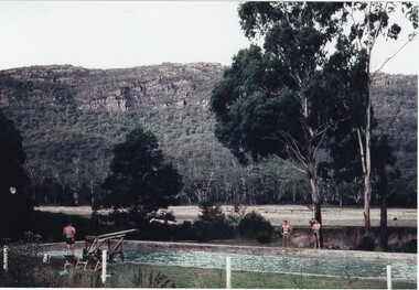
... Halls Gap & Grampians Historical Society Centennial Hall 117-119 Grampians Road Halls Gap grampians Jack Deller at end of diving board Graeme Chappell diving off of board Darryl Williams left and Doug Bottoms right opposite side of pool Occasion was Graeme's 21st birthday PEOPLERECREATION Sport AGFA People enjoying pool and diving board at Myrtlebank Guest House overlooked by Mt William Range. ...Jack Deller at end of diving board Graeme Chappell diving off of board Darryl Williams left and Doug Bottoms right opposite side of pool Occasion was Graeme's 21st birthdayPeople enjoying pool and diving board at Myrtlebank Guest House overlooked by Mt William Range.AGFApeoplerecreation, sport -
 Halls Gap & Grampians Historical Society
Photograph - Sepia, C 1900
... Halls Gap & Grampians Historical Society Centennial Hall 117-119 Grampians Road Halls Gap grampians Mt William Gold Mining MINING Gold mining Mafeking 1 copy B/W, 1 copy sepia 1 copy on display Looking towards Sugar Load and Mason's house from Spion Kop Six men in foreground with 2 covered wagons snow scene Photograph Sepia ...Mt William Gold MiningLooking towards Sugar Load and Mason's house from Spion Kop Six men in foreground with 2 covered wagons snow scene1 copy B/W, 1 copy sepia 1 copy on display mining, gold mining, mafeking -
 Halls Gap & Grampians Historical Society
Photograph - B/W, C 1900
... Road leading to Mt William goldfield 1900. George Mason's farmhouse on right hand side of road....ACCESS ROUTES Roads MINING Ladysmith Road leading to Mt William goldfield 1900. George Mason's farmhouse on right hand side of road. ...In early 1900, three Emmett brothers, with support from George Mason, set about following up a report of gold in the area. Confirmation of gold led to a gold rush in June 1900. Traffic from Ararat and Willaura passed Mason's Farm and it was on Mason's land that the first settlement, Ladysmith, sprang up.Road leading to Mt William goldfield 1900. George Mason's farmhouse on right hand side of road.access routes, roads, mining, ladysmith -
 Halls Gap & Grampians Historical Society
Photograph - B/W, C 1890
... Road Halls Gap grampians The man with the horse is Charles D'Alton, his cousin Alfred is beckoning him to come on. Charles was ther son of William D'Alton if "Silver Springs" on Dairy Creek, and Fred (Alfred) was the son of John D'Alton, Stawell Borough engineer. Fred and Charles were responsible for finding many of today's walking track routes through the Wonderland Range and in the Mt ...The man with the horse is Charles D'Alton, his cousin Alfred is beckoning him to come on. Charles was ther son of William D'Alton if "Silver Springs" on Dairy Creek, and Fred (Alfred) was the son of John D'Alton, Stawell Borough engineer. Fred and Charles were responsible for finding many of today's walking track routes through the Wonderland Range and in the Mt. Rosea area. The second copy is a transparency (slide) , no. 182 in the slide box.Photo shows man, left side corner with pack horse andother man middle ground with arm raised"Charles D'Alton beckoning to his cousin Alfred to come on" finding the best routegilbert rogers, vehicle track, people, d'alton -
 Halls Gap & Grampians Historical Society
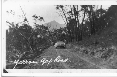
Photograph - B/W, C 1926
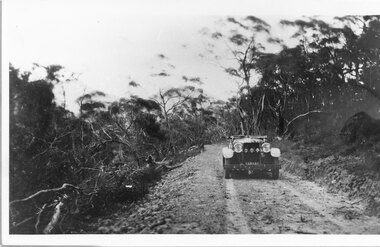
... Mirranatwa Gap was originally known as Yarram Gap; this name was given to the opposite gap on the Mt William side of the Dunkeld Road sometime in the mid 20th century. ...Halls Gap & Grampians Historical Society Centennial Hall 117-119 Grampians Road Halls Gap grampians Mirranatwa Gap was originally known as Yarram Gap; this name was given to the opposite gap on the Mt William side of the Dunkeld Road sometime in the mid 20th century. ...Mirranatwa Gap was originally known as Yarram Gap; this name was given to the opposite gap on the Mt William side of the Dunkeld Road sometime in the mid 20th century. An early touring car, claimed to be the first, crossing Mirranatwa (then Yarram) Gap.Photo shows car on Yarram Gap Road Road is rocky and unsealed. trees on left side of photo has been felledaccess routes, roads, yarram gap -
 Halls Gap & Grampians Historical Society
Photograph - B/W, C 1930s
... Halls Gap & Grampians Historical Society Centennial Hall 117-119 Grampians Road Halls Gap grampians Mirranatwa Gap was originally known as Yarram Gap The name later given to the adjacent gap in the Mt William Range sometime in the mid 20th century. ...Mirranatwa Gap was originally known as Yarram Gap The name later given to the adjacent gap in the Mt William Range sometime in the mid 20th century. This is an early touring car, claimed to be the first , crossing Mirranatwa gapPhoto shows car on road with man standing beside it. Road unsealed Trees on left side of road have been felled. access routes, roads, yarram gap -
 Halls Gap & Grampians Historical Society
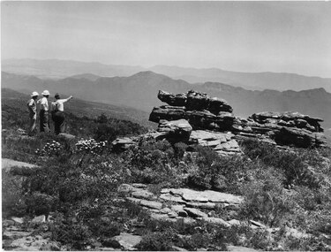
Photograph - B/W, C 1960s
... A track to the top of Mt William existed many years before, an all weather road was constructed in the early 1960s Not only did engineers and construction workers enjoy some spectacular scenery during "smokos" but so have thousands of tourists Some even experiencing the freezing gale force winds which greeting Major Thomas Mitchell and his party in July 1836s...Halls Gap & Grampians Historical Society Centennial Hall 117-119 Grampians Road Halls Gap grampians A track to the top of Mt William existed many years before, an all weather road was constructed in the early 1960s Not only did engineers and construction workers enjoy some spectacular scenery during "smokos" but so have thousands of tourists Some even experiencing the freezing gale force winds which greeting Major Thomas Mitchell and his party in July 1836s ACCESS ROUTES Walking track Roads Mount William WMT (Wimmera Mail Times} Photo shows 3 men looking over to Wonderland Range from Mt William. ...A track to the top of Mt William existed many years before, an all weather road was constructed in the early 1960s Not only did engineers and construction workers enjoy some spectacular scenery during "smokos" but so have thousands of tourists Some even experiencing the freezing gale force winds which greeting Major Thomas Mitchell and his party in July 1836sPhoto shows 3 men looking over to Wonderland Range from Mt William. Two men are wearing hard hats The third man a felt hat - he is pointing to a point in the distanceWMT (Wimmera Mail Times}access routes, walking track, roads, mount william -
 Halls Gap & Grampians Historical Society
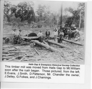
Photograph - B/W
... Halls Gap & Grampians Historical Society Centennial Hall 117-119 Grampians Road Halls Gap grampians This timber mill was moved from Halls Gap to Mt William soon after the rush began. ...This timber mill was moved from Halls Gap to Mt William soon after the rush began. Those pictured (from left to right) are: E Evans, J Smith, D Patterson, Mr Chandler (the owner), J Delley, G Folkes and J Chamings.The photo shows seven men grouped around a large saw, which is driven by a traction engine. There arethree large logs and wood scraps in the foreground and a pile of sawdust can be seen behind the saw.timber industries, logging, sawmilling -
 Halls Gap & Grampians Historical Society
Photograph - B/W, C 1960s
... Halls Gap & Grampians Historical Society Centennial Hall 117-119 Grampians Road Halls Gap grampians This photo was taken in the Mt William area and was material for a Ministry of Tourism campaign. ...This photo was taken in the Mt William area and was material for a Ministry of Tourism campaign.The photo shows a man seated on a rock and looking out over a valley (Mt William area, south west)'This Photograph is with, The Compliments of The . . . ,Ministry of Tourism, Government of Victoria, Please acknowledge, Photo: Michael Chesire' stamped on back. 'Grampians Mt. William' written on back in red pen.scenery, mount william -
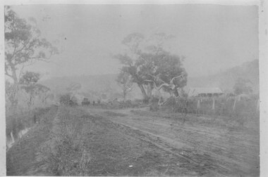 Halls Gap & Grampians Historical Society
Photograph - B/W
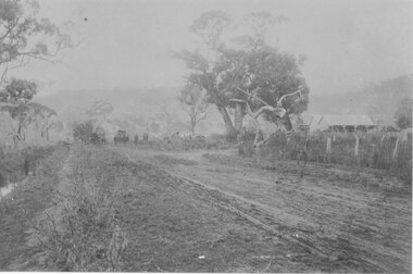
... This is a photo of Mason's house, on the road to Ladysmith in the Mt William gold fields....Halls Gap & Grampians Historical Society Centennial Hall 117-119 Grampians Road Halls Gap grampians This is a photo of Mason's house, on the road to Ladysmith in the Mt William gold fields. BUILDINGS Houses The photo appears to have been taken on a foggy day. ...This is a photo of Mason's house, on the road to Ladysmith in the Mt William gold fields.The photo appears to have been taken on a foggy day. It shows an unsealed road flanked by a few gum trees and with a ditch containing water on the left. On the right in the middle distance there is a house with a twin pitched roof and a veranda at the front. In the distance on the road is a vehicle and what appears to be a few people. The are mountains in the far background.buildings, houses -
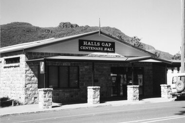 Halls Gap & Grampians Historical Society
Photograph - Coloured
... Road Halls Gap grampians Halls Gap Hall c2000. for further info see Rec.389. BUILDINGS Halls A stone faced building with a veranda in front. The supports are surrounded by rock piers. A sign appears over the door "Halls Gap Centenary Hall". A vehicle is parked in front of Building. Mt. William ...Halls Gap Hall c2000. for further info see Rec.389. A stone faced building with a veranda in front. The supports are surrounded by rock piers. A sign appears over the door "Halls Gap Centenary Hall". A vehicle is parked in front of Building. Mt. William Range is in background.buildings, halls -
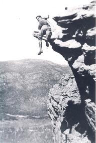 Halls Gap & Grampians Historical Society
Photograph - Transparency, C 1920s
... Road Halls Gap grampians Gilbert Francis Rogers (1884-1950). Born In Gawler,S.A. came to Halls Gap as a photographer. He soon became a guide as well as a photographer, often setting up his camera and then posing in the most unusual positions PEOPLE Gilbert Rogers Man with wearing boots with photographic equipment set up ,balancing on a ridge of a mountain range. Mt. William ...Gilbert Francis Rogers (1884-1950). Born In Gawler,S.A. came to Halls Gap as a photographer. He soon became a guide as well as a photographer, often setting up his camera and then posing in the most unusual positionsMan with wearing boots with photographic equipment set up ,balancing on a ridge of a mountain range. Mt. William Range is in the background, Fyans Valley/Halls Gap is visible below.people, gilbert rogers -
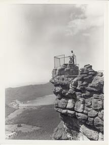 Halls Gap & Grampians Historical Society
Photograph - B/W, C 1960s
... Halls Gap & Grampians Historical Society Centennial Hall 117-119 Grampians Road Halls Gap grampians Photo is of 'The Pinnacle' lookout with Lake Bellfield in the background flanked by the Mt. William ...Photo is of 'The Pinnacle' lookout with Lake Bellfield in the background flanked by the Mt. William range. the photo is typical of 'tourism' photos taken by the Victorian Railways.Photo shows a man and a woman on top of a rocky outcrop that overlook a valley. A lake with a dam wall and rock tiers cut into the hillside can be seen as well as cleared areas some buildings. the lookout is enclosed with a wire fence.scenery, lookouts -
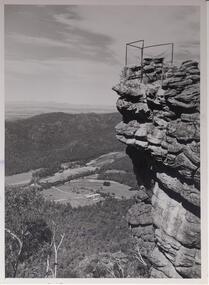 Halls Gap & Grampians Historical Society
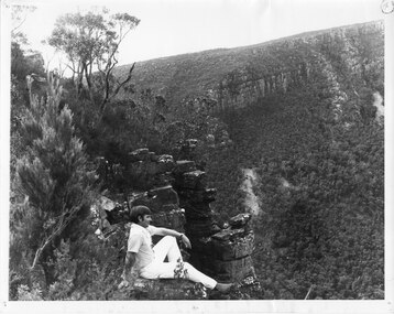
Photograph - B/W, C 1960s
... Photo shows rocky outcrop surrounded by a wire fence and overlooking a valley with roads,some cleared areas and buildings. The Mt. William range can be seen middle left in the photo....Photo shows rocky outcrop surrounded by a wire fence and overlooking a valley with roads,some cleared areas and buildings. The Mt. William range can be seen middle left in the photo. ...Lookout is known as 'The Pinnacle'. Valley is the Fyans Valley.Photo shows rocky outcrop surrounded by a wire fence and overlooking a valley with roads,some cleared areas and buildings. The Mt. William range can be seen middle left in the photo.On back notes "bellfield' but neither Bellfield Peak or Bellfield lookout can be seen.scenery, lookouts -
 Mortlake and District Historical Society
Travellers ticket, Unknown, Unknown - 19th Century
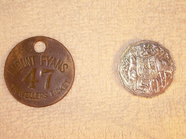
... road Metal 'traveller's tickets' were issued at the gate of Mt. Fyans to itinerant workers and travellers passing through the district; they could be redeemed at the homestead for a meal and/or a bed for the night at the station workers' lodgings. Mt Fyans was a significant pastoral property in the Dundonnel area of the Western District. Originally settled in 1841 by Lachlan Mckinnon, by 1856 the Mt.Fyans portion comprised over 48,000 acres. By 1898 when it was sub-divided on the death of then owner William ...Metal 'traveller's tickets' were issued at the gate of Mt. Fyans to itinerant workers and travellers passing through the district; they could be redeemed at the homestead for a meal and/or a bed for the night at the station workers' lodgings. Mt Fyans was a significant pastoral property in the Dundonnel area of the Western District. Originally settled in 1841 by Lachlan Mckinnon, by 1856 the Mt.Fyans portion comprised over 48,000 acres. By 1898 when it was sub-divided on the death of then owner William Cumming, it comprised 9000 acres. Pastoral properties relied heavily on a semi-skilled workforce whose numbers were seasonally varied - hence the need for itinerant labour. Circular metal 'travellers ticket' with hole punched through at the top for hanging/ storage. MOUNT FYANS 47 TRAVELLERS TICKETmt fyans western district pastoral property workforce intinerant swagmen -
 Eltham District Historical Society Inc
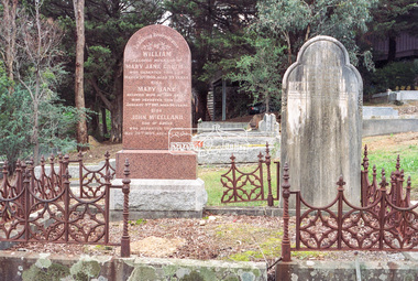
Negative - Photograph, Harry Gilham, Graves of William J and Mary Jane (nee Vance) Crozier and their sons Thomas Vance and John McClelland Crozier, Eltham Cemetery, Victoria, 1 Aug 2007
... It was situated on twenty-four acres along the track at its rise, about half-a-mile east of Maria Street (Main Road) bounded by Mt Pleasant Road on the south and Pitt Street northwards. William Crozier used the land for cultivation and grazing. ...It was situated on twenty-four acres along the track at its rise, about half-a-mile east of Maria Street (Main Road) bounded by Mt Pleasant Road on the south and Pitt Street northwards. William Crozier used the land for cultivation and grazing. ...William Crozier was born 1823 in County Armagh, Ireland. Mary Jane Vance was born 1829 in Desecrete, County Tyrone, Ireland. They were married in 1848. On New Year's Eve, 1849, together with their baby daughter Sarah, William and Mary embarked from Plymouth aboard the Eliza Caroline, as assisted immigrants, for Port Phillip, arriving 31 March 1850 from where they journeyed out to Eltham on a bullock wagon. The Croziers were Episcopalians and soon after arriving in Eltham the Wesleyans of Little Eltham were holding services in the Crozier's home, among other locations. It was not until January 1856 that the Wesleyan church first acquired land in Henry Street for a chapel, which later became the home of the Eltham Hall. The Crozier home, known as ‘Belmont’ was weatherboard with a rammed earth floor. It was situated on twenty-four acres along the track at its rise, about half-a-mile east of Maria Street (Main Road) bounded by Mt Pleasant Road on the south and Pitt Street northwards. William Crozier used the land for cultivation and grazing. The track the Eltham Wesleyans took, by foot or horse, was along the Mt Pleasant Road, and like most roads of the time, a dusty trail in summer and a hoof and cart rutted quagmire in winter. William and Mary Crozier had seven children: Sarah, (1848 Ireland), John McClelland (1851 Eltham), Eliza (1855 Eltham), William (1857 Eltham), Jane(1859 Yarraville), Charlotte Amelia (1861 Yarraville), and Thomas Vance (1864 Eltham). The Crozier farm prospered and in 1870, William applied for, and was granted a leasehold on an additional sixty-three-acre selection, half-a-mile east of his twenty-four-acre Mt Pleasant Road property. Upon this property he built a two-roomed dwelling of slats and bark and a storeroom of log and bark, ten feet square. In 1880 he applied for a Crown grant of the property. Tragedy struck the family in 1882 when the youngest, Thomas Vance at age 17 accompanied by John Anderson, went into "Hall's Dam" to bathe, neither of them being able to swim. On wading out together, Crozier suddenly slipped into a part about 10ft. deep, and sank, after rising only once. Anderson pluckily tried to save him, nearly losing his own life in the attempt, saving himself when sinking for the last time by seizing hold of a projecting root. The body was not recovered until two hours after, when Mr. Thomas Bell, a farmer in the locality, who was attracted to the spot, on hearing of the occurrence, although unable to swim, plunged in with a rope around his waist, and succeeded with some difficulty in bringing it to the surface. Their eldest son, John also died prematurely at age 42 when he was killed by a falling tree branch whilst engaged in ring-barking trees at Eltham. A still cold wind was blowing and John, and others who were working with him, sheltered themselves at lunch time by sitting on the side of a large tree. When thus seated, the wind detached a limb of the tree which sheltered them, and though they heard the cracking, they had not time to get clear before the limb fell. It struck John on the head, and felled him to the ground, He appeared to be suffering severe pain, and two of his companions conveyed him to the Melbourne Hospital, where during the night he was operated upon for a fracture of the skull. Despite the operation being successful, John ultimately succumbed to his injuries the following afternoon. In good times William was known for his wealth of reminiscences of the early days of the district however his health failed him for several years until his death in March 1909. He was a man of very industrious habits, of a retiring disposition and much esteemed by those who knew him best. Mary died in January 1915 after a long illness. They are buried together along with their sons John and Thomas in the Eltham Cemetery. In Loving Remembrance William Beloved husband of Mary Jane Crozier Who departed this life March 31st 1909, aged 85 years Also Mary Jane Beloved wife of the above Who departed this life January 3rd 1915, aged 86 years Also John McCelland Son of the above Who departed this life May 20th 1894, aged 42 years also Sacred Memory of Thomas Vance Dearly beloved son of William J. Crozier Who departed this life at Eltham, February 3rd 1882 Aged 17 yearseltham cemetery, gravestones, memorials, film - kodak gold gc 400-9, john mccelland crozier, mary jane crozier (nee vance), scan - 35mm negative, thomas vance crozier, william crozier, william j crozier -
 Eltham District Historical Society Inc
Slide - Photograph, Eltham Cemetery, Mt Pleasant Road, Eltham, 27 May 1990
... He travelled on to St Katherines, St Helena, where he talked on the history of the church and cemetery. eltham activities shire of eltham historical society cemetery excursion eltham cemetery graves Anna Brinkkotter Anton Brinkkotter Anton William Brinkkotter 35mm colour positive transparency (1 of 23) Mount - Agfachrome Agfa CS System black 8 dots Eltham Cemetery, Mt Pleasant Road, Eltham Slide Photograph ...Local Cemetery Excursion Sunday 27 May 1990 departed Eltham Shire Office at 9.30am and finish mid afternoon. Visits to Eltham , Kangaroo Ground, Queenstown (Smiths Gully), Nillumbik (Diamond Creek), St Katherines (St Helena) Hurst family graves at Hurstbridge and a little known early cemetery at Grteensborough. Attended by 20 members. In each case we were introduced to the cemetery with a brief talk. At Eltham, Frank Burgoyne gave us the benefit of his knowledge as a member of the cemetery trust and at Kangaroo Ground, Bruce Ness spoke in a similar capacity. The lunch stop was at Hurstbridge where we visited the Hurst family graves. The President of Nillumbik Historical Society, Jock Ryan, joined us at the Nillumbik (Diamond Creek) cemetery. He travelled on to St Katherines, St Helena, where he talked on the history of the church and cemetery.35mm colour positive transparency (1 of 23) Mount - Agfachrome Agfa CS System black 8 dotseltham, activities, shire of eltham historical society, cemetery excursion, eltham cemetery, graves, anna brinkkotter, anton brinkkotter, anton william brinkkotter -
 Eltham District Historical Society Inc
Photograph, Betty Lynch (left), Russell and Marion Yeoman at the Everard Memorial, Mt Everard, Kinglake National Park, c.April, 2004, 2004
... William Everard and sister of Blanche Shallard This photo appears to have been taken at a later date to the dedication ceremony of 22 April. This lockup used to be located at the Police Station in Pryor Street and was then stored in Youth Road before being acquired for the Local History Centre betty lynch everard memorial mt everard kinglake national park blanche shallard Colour photograph Betty Lynch (left), Russell and Marion Yeoman at the Everard Memorial, Mt Everard, Kinglake National Park, c.April, 2004 Photograph Photograph ...Betty Lynch OAM, daughter of William Everard and sister of Blanche Shallard This photo appears to have been taken at a later date to the dedication ceremony of 22 April.This lockup used to be located at the Police Station in Pryor Street and was then stored in Youth Road before being acquired for the Local History Centre Colour photographbetty lynch, everard memorial, mt everard, kinglake national park, blanche shallard