Showing 21 items matching "muckleford"
-
 Ballarat Heritage Services
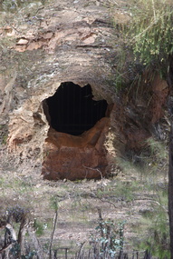
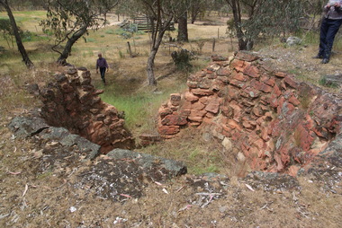
Photograph - Colour, Adit at Frenchman's Reef, Muckleford State Forest, 2017, 17/10/2017
... Adit at Frenchman's Reef, Muckleford State Forest, 2017...Colour photographs a tunnel at Frenchmans Reef in the Muckleford State Forest....Muckleford State Forest, Victoria, Australia...Ballarat Heritage Services PO Box 2209 Bakery Hill Post Office goldfields muckleford state forest goldfields mining tunnel Frenchman's Reef frenchmans reef Colour photographs a tunnel at Frenchmans Reef in the Muckleford State Forest. ...Colour photographs a tunnel at Frenchmans Reef in the Muckleford State Forest.muckleford state forest, goldfields, mining, tunnel, frenchman's reef, frenchmans reef -
 Ballarat Heritage Services
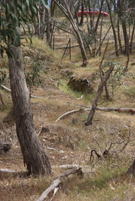
Photograph - Colour, Clare Gervasoni, Former Goldfield in the Muckleford State Forest, 2017, 17/10/2017
... Former Goldfield in the Muckleford State Forest, 2017...Colour photographs showing former goldminig sights in the Muckleford State Forest....Ballarat Heritage Services PO Box 2209 Bakery Hill Post Office goldfields muckleford state forest goldfields mining Colour photographs showing former goldminig sights in the Muckleford State Forest. ...Colour photographs showing former goldminig sights in the Muckleford State Forest.muckleford state forest, goldfields, mining -
 Ballarat Heritage Services
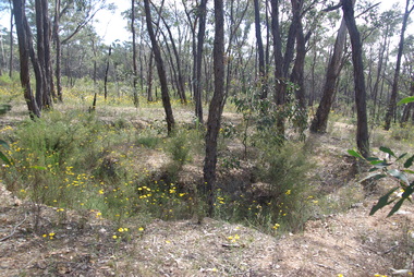
Photograph - Colour, Clare Gervasoni, Former Goldfield in the Muckleford State Forest, 2017, 17/10/2017
... Former Goldfield in the Muckleford State Forest, 2017...Colour photographs showing former goldminig sights in the Muckleford State Forest....Ballarat Heritage Services PO Box 2209 Bakery Hill Post Office goldfields muckleford state forest goldfields mining Colour photographs showing former goldminig sights in the Muckleford State Forest. ...Colour photographs showing former goldminig sights in the Muckleford State Forest.muckleford state forest, goldfields, mining -
 Uniting Church Archives - Synod of Victoria
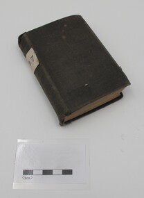
Book, Wesleyan Conference Office, Memoirs of the Rev. David Stoner, n.d
... There is a book plate inside the book indicating that the book was the property of Muckleford Wesleyan Sabbath School. It has square paper label on its spine. 344 p. ..."WSS Muckleford" Spine: "127"...Muckleford Wesleyan Sabbath School Rev David Stoner 1794 - 1826 "WSS Muckleford" Spine: "127" Small hardcover book covered with dark cloth using black thread to secure it. ...Small hardcover book covered with dark cloth using black thread to secure it. There is a book plate inside the book indicating that the book was the property of Muckleford Wesleyan Sabbath School. It has square paper label on its spine. 344 p. There is an image of David Stoner opposite the title page.muckleford wesleyan sabbath school, rev david stoner 1794 - 1826 -
 Lions Club of Maldon Inc.
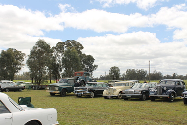
Photographs, Mucklefest 2016
... muckleford...Photographs taken at the 2016 Muckleford Mucklefest held at the Muckleford Railway Station...Lions Club of Maldon Inc. 61-63 High St Maldon goldfields muckleford mucklefest maldon vintage machinery museum mount alexander vintage engine club victorian goldfields railway walmer fire brigade train railway Photographs taken at the 2016 Muckleford Mucklefest held at the Muckleford Railway Station Mucklefest 2016 Photographs Robert Thompson Robert Thompson ...Photographs taken at the 2016 Muckleford Mucklefest held at the Muckleford Railway Stationmuckleford, mucklefest, maldon vintage machinery museum, mount alexander vintage engine club, victorian goldfields railway, walmer fire brigade, train, railway -
 Castlemaine Art Museum
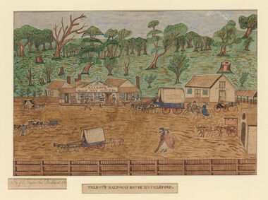
Painting, J. Taylor, Talbot's Half-way House Muckleford, c. 1864
... Talbot's Half-way House Muckleford...Castlemaine Art Museum 14 Lyttleton Street Castlemaine goldfields Talbot's Half-way House Muckleford Painting J. Taylor ...Gift of the Talbot Family, 1962 -
 Maldon Brass Band Inc.
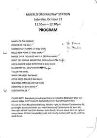
Document, Setlist Muckleford Railway Station 23/10/2010
... Setlist Muckleford Railway Station 23/10/2010...Francis Street Maldon goldfields Setlist Muckleford Railway Station 23/10/2010 Document ... -
 Warrnambool and District Historical Society Inc.
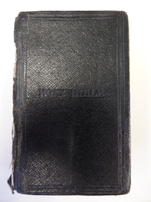
Book, Holy Bible, 1924
... But Doris Ware, the recipient of this, was probably the woman born in Echuca in 1887, the daughter of John and Sarah Ware and no other details are available on her. Muckleford is a town near Castlemaine. ...‘Presented to Doris Ware from the Muckleford Methodist Sunday School. C.W. Talbot Sec.’ ’25.2.28’ ...Doris Ware History of Warrnambool ‘Presented to Doris Ware from the Muckleford Methodist Sunday School. C.W. Talbot Sec.’ ’25.2.28’ This is a black leather-covered book of 1016 pages. ...The Ware families were prominent early settlers in the Warrnambool district. But Doris Ware, the recipient of this, was probably the woman born in Echuca in 1887, the daughter of John and Sarah Ware and no other details are available on her. Muckleford is a town near Castlemaine. This book has been in the collection of the Warrnambool and District Historical Society for many years so it is presumed it has some connection to the local pioneering Ware families.This is a black leather-covered book of 1016 pages. The cover has embedded lettering on the front cover and gold lettering on the spine. The cover has come apart from the binding and has been mended with adhesive tape. The spine section of the cover is completely detached from the binding. The inscription is handwritten in black ink with later writing in blue ink. ‘Presented to Doris Ware from the Muckleford Methodist Sunday School. C.W. Talbot Sec.’ ’25.2.28’ doris ware, history of warrnambool -
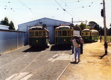 Ballarat Tramway Museum
Photograph - Colour Photograph/s - set of 8, Carolyn Dean, 22/11/2000 12:00:00 AM
... ... Muckleford...Set of eight colour prints of the Ballarat COTMA Conference 2000 visits to the MTPA depot at Haddon, the township of Clunes and to CMR Muckleford Photographed on 22/11/2000 at Haddon and on 23/11/2000 at Clunes and Muckleford. ...Set of eight colour prints of the Ballarat COTMA Conference 2000 visits to the MTPA depot at Haddon, the township of Clunes and to CMR Muckleford Photographed on 22/11/2000 at Haddon and on 23/11/2000 at Clunes and Muckleford. ...Set of eight colour prints of the Ballarat COTMA Conference 2000 visits to the MTPA depot at Haddon, the township of Clunes and to CMR Muckleford Photographed on 22/11/2000 at Haddon and on 23/11/2000 at Clunes and Muckleford. Photographs by Carolyn Dean. .1 - No. 663, 670 and 407 at Haddon MTPA depot .2 - COTMA delegates at Haddon BBQ .3 - No. 407 on operating track at Haddon .4 - Clunes war memorial .5 - Clunes township main street .6 - Muckleford station nameboard .7 - J549 at Muckleford station .8 - ditto Printed on Kodak paper.On rear of each print is "263.3 or .4, or .5" and date "22.11.00" or "23.11.00" in ink.btm, haddon, cotma, muckleford, clunes, tram 663, tram 670, tram 407 -
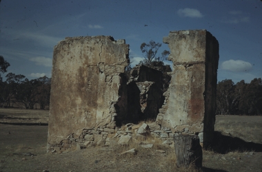 Bendigo Historical Society Inc.
Slide - MALDON & SURROUNDING AREAS, Apr 1968
... House remains at Muckleford....House remains at Muckleford. Slide MALDON & SURROUNDING AREAS ...Slide. Maldon & Surrounding Areas. House remains at Muckleford.slide, maldon & surrounding areas., maldon & surrounding areas. -
 Old Castlemaine Schoolboys Association Inc.
Book, A history of Seventeen Central Victoria Schools
... Baringhup, Baringhup East, Baringhup West, Bradford, Brokenback, Eastville, Gowar, Muckleford, Muckleford South, Neereman, Nuggetty, Porcupine Flat, Shelbourne, Shelbourne South, Tarrangower, Walmer, Walmer North...Old Castlemaine Schoolboys Association Inc. 123 Mostyn Street CASTLEMAINE goldfields Baringhup, Baringhup East, Baringhup West, Bradford, Brokenback, Eastville, Gowar, Muckleford, Muckleford South, Neereman, Nuggetty, Porcupine Flat, Shelbourne, Shelbourne South, Tarrangower, Walmer, Walmer North A history of Seventeen Central Victoria Schools Book Ken James Sue Barnett Ken James Sue Barnett ...Baringhup, Baringhup East, Baringhup West, Bradford, Brokenback, Eastville, Gowar, Muckleford, Muckleford South, Neereman, Nuggetty, Porcupine Flat, Shelbourne, Shelbourne South, Tarrangower, Walmer, Walmer North -
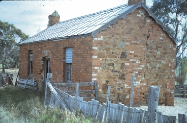 Bendigo Historical Society Inc.
Slide - MALDON & SURROUNDING AREAS, Apr 1968
... An old house on the Muckleford to Castlemaine Road....An old house on the Muckleford to Castlemaine Road. Slide MALDON & SURROUNDING AREAS. ...Slide. Maldon & Surrounding Areas. An old house on the Muckleford to Castlemaine Road.slide, maldon & surrounding areas., maldon & surrounding areas. -
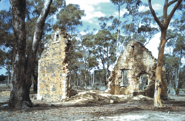 Bendigo Historical Society Inc.
Slide - MALDON & SURROUNDING AREAS, Apr 1968
... The remains of Gower School, on the side of Muckleford Road....The remains of Gower School, on the side of Muckleford Road. Slide MALDON & SURROUNDING AREAS. ...Slide. Maldon & Surrounding Areas. The remains of Gower School, on the side of Muckleford Road.slide, maldon & surrounding areas., maldon & surrounding areas. -
 Ballarat Heritage Services
Photograph - Colour, Clare Gervasoni, Thornhill Reef Quartz Roasting Kilns, 2017, 17/10/2017
... Colour photographs of the Thornhill Reef Quartz Roasting Kilns in the Muckleford State Forest....Ballarat Heritage Services PO Box 2209 Bakery Hill Post Office goldfields muckleford state forest goldfields mining Colour photographs of the Thornhill Reef Quartz Roasting Kilns in the Muckleford State Forest. ...Colour photographs of the Thornhill Reef Quartz Roasting Kilns in the Muckleford State Forest.muckleford state forest, goldfields, mining -
 Bendigo Historical Society Inc.
Document - LANDS OFFICE: SANDHURST AND DISTRICT CROWN LAND SOLD BY AUCTION 1854
... ... Muckleford...Harcourt, Lockwood, Muckleford' Blue lined pages with copy of advertisement for town lots for auction. ...Harcourt, Lockwood, Muckleford' Blue lined pages with copy of advertisement for town lots for auction. ...Document: booklet, brown paper cover secured by string on spine. Written on front cover ' copy of sale books, January 16, 17. 18, 19, 26 1854. Harcourt, Lockwood, Muckleford' Blue lined pages with copy of advertisement for town lots for auction. LH page columns: price per acre, amount, deposit. RH page balance, purchaser, name, residence. White sticker fixed to pocket: Book 4 Sandhurst Land Sales, including outlying areas 16 January 1854 to 19 January 1854.lands office, bendigo, sandhurst, harcourt, muckleford, lockwood, land sales, auctions -
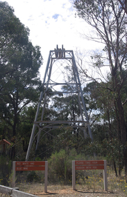 Ballarat Heritage Services
Photograph - Colour, Red, White and Blue Mine near Maldon, 2017, 17/10/2017
... Colour photograph of the Red, White and Blue historic mine site in the Muckleford State Forest, showing an intact poppet head with tubular steel legs, winding wheels and remains of timberwork....It was also known as the Golden Age Mine and as Malney's Red, White and Blue Mine. red, white and blue mine maldon golden age mine maloney's red, white and blue muckleford state forest Colour photograph of the Red, White and Blue historic mine site in the Muckleford State Forest, showing an intact poppet head with tubular steel legs, winding wheels and remains of timberwork. ...The Red, White and Blue mine is a site of historical, areaological and scientific importance to Victoria, and is listed on the Victorian Heritage Register of significant heritage places. It was also known as the Golden Age Mine and as Malney's Red, White and Blue Mine. Colour photograph of the Red, White and Blue historic mine site in the Muckleford State Forest, showing an intact poppet head with tubular steel legs, winding wheels and remains of timberwork.red, white and blue mine, maldon, golden age mine, maloney's red, white and blue, muckleford state forest -
 Bendigo Historical Society Inc.
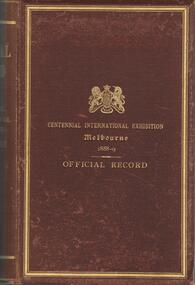
Book - CENTENNIAL INTERNATIONAL EXHIBITION, MELBOURNE 1888-1889
... Shaw, Goornong, page 310 A. Trinkaus, Muckleford, page 311 Albert Bruhn listed in competitors for Burgoyne Prize Bendigo Pottery Co, page 606....Shaw, Goornong, page 310 A. Trinkaus, Muckleford, page 311 Albert Bruhn listed in competitors for Burgoyne Prize Bendigo Pottery Co, page 606. ...Maroon cover, gold print and trim, 1138 pages. On front of book 'Centennial International Exhibition Melbourne, 1888-9 Official Record' Patrick Payes, Mayor of the City of Sandhurst (Bendigo) was a member of the Commission and listed with other members of the Commission. The International Exhibition of Works of Industry and Art at Melbourne was held to commemorate the centenary ' of the founding of the first Colony of Australia' Some Bendigo exhibits include: Page 631: exhibit 1797, Harry J., Knape Street, American Gully, Sandhurst, Victoria - working model of a gold mine. Exhibit 1810, Percy and Hunter, Wattle street Sandhurst, Victoria - safety fuses for blasting operations. Exhibit 1811, Plainbeck, Hermann, Sandhurst, Model of a mine. The wine exhibits: page 304 - 317 A. Bruhn, EmuCreek page 305 - 306 F.Grosse, Strathfieldsaye page 307 W. Jones, Mandurang, page 309 H. Meyer, Mandurang, page 309 E. Schroeder, Castlemaine, page 310 F.K. Shaw, Goornong, page 310 A. Trinkaus, Muckleford, page 311 Albert Bruhn listed in competitors for Burgoyne Prize Bendigo Pottery Co, page 606.australia, history, centennial international exhibition -
Ballarat Heritage Services
Document, Castlemaine Research Notes for CAGHM interpretation
... ...Muckleford...Ballarat Heritage Services PO Box 2209 Bakery Hill Post Office goldfields Castlemaine Swimming Pool Aboriginies Major mitchell gold commerce religion Education sport music federation Geology Dja Dja Wurrung Mt franklin Protectorate Edward Stone Parker Alexander Kennedy Campaspe Coliban Mount Alexander Muckleford Plaistowe Joyce borthers Strathloddon Yapeem Straford Lodge James Orr Chinese Campbell's Creek yapeen Fryers Creek Guildford harcourt Newstead Yappen Word doc of resarch relating to Castlemaine, Victoria Castlemaine Research Notes for CAGHM interpretation, Document ...Word doc of resarch relating to Castlemaine, Victoriacastlemaine swimming pool, aboriginies, major mitchell, gold, commerce, religion, education, sport, music, federation, geology, dja dja wurrung, mt franklin protectorate, edward stone parker, alexander kennedy, campaspe, coliban, mount alexander, muckleford, plaistowe, joyce borthers, strathloddon, yapeem, straford lodge, james orr, chinese, campbell's creek, yapeen, fryers creek, guildford, harcourt, newstead, yappen -
 Federation University Historical Collection
Book, Victorian Government Legislative Assembly, The Select Committee on Castlemaine and Sandhurst water supply, Report from the Select Committee on Castlemaine and Sandhurst Water Supply, together with the proceedings of the Committee, minutes of evidence and appendices, 19/5/1865 (exact)
... ...muckleford...He was assistant engineer for the Ballaarat and Ballarat East Water Supply Committee and helped plan local reservoirs. water supply victoria castlemaine directories sandhurst directories ballarat directories james blackburn edward wardle daylesford water race c j taylor george avery fletcher bagge ohlfsen bagge george foote john h reilly ambrose johnson george francis timber preservation james forbes alfred surplice malcolm carmichael robert adams frederick hugh thomas h o christerpherson william downe thomas lawrence brown francis hadgson nixon strangways guildford maldon muckleford lauriston malmesbury franklinford walmer strathloddon downe ferdinand krause m7082 trentham castlemaine drummond metcalfe sutton grange lockwood ravenswood mandurang yandoit c.h. ohlfsen bagge moorabool reservoir gong gong reservoir harry beale's reservoir pincott reservoir frank pinkerton water A signature by "Ferdinand M. ...This book contains the report from the select committee on Castlemaine and Sandhurst water supply; with the proceedings of the committee, minutes of evidence and appendices. It also contains the report Of the Engineer-In-Chief of Railways, and reply of the Chief Engineer of Water Supply on the works constructed by the Victorian Water Supply Department, presented to both houses of parliament by His Excellency’s command. Ferdinand M. Krause, was a lecturer at the Ballarat School of Mines in Geology Mineralogy Mining Engineering and Surveying. He was a Fellow of the Geological Society and a Fellow of the Linnian Society. He was assistant engineer for the Ballaarat and Ballarat East Water Supply Committee and helped plan local reservoirs.A brown cloth hard cover, foolscap book with leather spine. Title is written in black on the title page. "Water Supply Reports" is engraved in gold on spine. It includes a table showing the monthly and yearly rainfall and shade temperature at Ballarat, 2nd February, 1885. It also includes two reports and two replies, a map No.7082.2 of Victorian Water Supply, Castlemaine and Sandhurst district general plan including lines of Aqueduct, Reservoirs. No. 7082.3 of Victorian Mining districts, Mining Divisions and The Gold Fields in 1866 - includes districts to be supplied under the Waterworks Act, 1965. It also includes: *Report of the Engineer-in-chief of Railways and Reply of the Chief Engineer of Water Supply on the works constructed by the Victorian Water Supply Department, 1869. * Coliban Water Scheme, 1864 * Ballarat and Ballarat East Water Supply (1869) including the Ballarat Water Supply List containing names of occupiers and nature of improvements on lands comprised within the proposed reserve of Gong Gong Reservoir, Ballaarat. At Warrenheip the names included: Honora McCallin, William Honan, C. McMahon, Patrick McMahon, J.P. Beach, J.H. Smith, Michael Nestor, Martin Quinn, Martin McIntyre, Robert Higgins, Coleman Kane, Robert Bond. At Ballarat: William Clarke, Richard White, John Hosking, Wesleyan Chapel, J. Hewitt, Robert McRobinson. At Bungaree: John Pullin, John Llewellyn. William Daw, Smith and Wynne, William Brough, A. Alexander. * Ballarat and Ballaarat East Water Supply report upon the advisability, or otherwise, of constructing a reservoir at the junction of the Yarrowee Creek and Gile's Creek, upon a site known as Gile's Reservoir (printed by Frank Pinkerton). This report has numerous notes written on it (most probably by Krause) and includes the capacity of Harry Beale's Reservoir, Pimcott's Reservoir and the Proposed Gong Gong Reservoir. * Statement as to the position of the Ballaarat and Ballaarat East Borough Councils in Connection with Water Supply, September 1869. * Ballarat and Ballaarat East Water Supply - General Statement upon the Ballaarat and Ballaarat east Scheme of Water Supply. Includes information on Moorabool reservoir, Harry Beale's Reservoir, Lal Lal Creek, Two Mile Creek, Beale's Dam, Yarrowee Creek, Gong Gong Reservoir, Kirk's Dam, Devil's Creek, Moorabool Creek. Additional handwritten notes (probably by Krause) * Engineer's Report on the resolution of the COmmittee of Water Supply, of the 7th July 1868. The report refers to the Country around Mount Warrenheip. Names mentioned are L. Abraham, Great North-West Gold Mining Company, Border Sawmills, Ferdinand Krause, Ohlfsen Bagge, W.H. Shaw, A signature by "Ferdinand M. Krause" at the top corner of the title page. A few pages have handwriting on the margins, it is believed to be his handwriting. water supply victoria, castlemaine directories, sandhurst directories, ballarat directories, james blackburn, edward wardle, daylesford water race, c j taylor, george avery fletcher, bagge, ohlfsen bagge, george foote, john h reilly, ambrose johnson, george francis, timber preservation, james forbes, alfred surplice, malcolm carmichael, robert adams, frederick hugh thomas, h o christerpherson, william downe, thomas lawrence brown, francis hadgson nixon, strangways, guildford, maldon, muckleford, lauriston, malmesbury, franklinford, walmer, strathloddon, downe, ferdinand krause, m7082, trentham, castlemaine, drummond, metcalfe, sutton grange, lockwood, ravenswood, mandurang, yandoit, c.h. ohlfsen bagge, moorabool reservoir, gong gong reservoir, harry beale's reservoir, pincott reservoir, frank pinkerton, water -
 Bendigo Historical Society Inc.
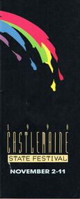
Document - CASTLEMAINE STATE FESTIVAL, CASTLEMAINE, 2 November 1990
... Another Stroll round Castlemaine, Historical Society. Muckleford Tour, Naturalists Club. 'Sketches' The Argus Guitar Quartet, Jochen Sxhubert, Tania Ravbar, Samantha Tout, Chi Ly.Scores for Instruments and Voices, Phylis Bachelor. ...Stroll round Castlemaine Historical Society. Muckleford Tour Naturalists Club. 'Sketches' The Argus Guitar Quartet Jochen Sxhubert Tania Ravbar Samantha Tout Chi Ly.Scores for Instruments and Voices Phylis Bachelor. ...Castlemaine State Festival, Castlemaine. 2 November 1990. Programme. From the Chairmen - Mr Bereck Segan. Melbourne Committee: B R Segan, O.B.E. (Chairman), M Besen, A.O. (Deputy Chairman), Mrs H Dore (Hon. Sec.), C Anzarut, N Bourke, Ms M Coillet, Prof. C Duckworth, G Fairfax, A.M., K MacKenzie-Forbes, A.M., Mrs B Margetts, Dr F R Moulds, I.S.O., R Nordlinger, J Parker, M.B.E., A Porter, Ms M Prendergast, C Pyett, Ms D Reilly, Mrs, Ms L Schiftan, P M Schiftan, D Segan, B J Stewart, Ms S Walker, Dr R Wlikie. Melbourne Committee: I O'Halloran, (Chairman), Mrs M Rilen (Hon.Sec.), Miss R Wood (Treas), Mrs L Bennet, Mrs M Bock, S Cox, Cr T Daniell, Mrs H Griffiths, B Heydon, N Jennings, Mrs C McKellar, Miss M Oliver, L O'Toole, F Ransome-Smith, J Shortal, Dr D Silver, Mrs V Victor-Gordon, Mes E Warren, Miss L Waters. Welcome to the 1990 Castlemaine State Festival. As one festival closes, planning for the next commences immediately.. . Mr Ian O'Halloran, Chairman, Castlemaine. Castlemaine State Festival Administration, Festival Manager: Phee Broadway, Manager's Assistant: Mary Harris, Technical Manager: Lis Pain, Drawing Prize Co-ordinator: Bev Singleton, Farnham Concert Co-Ordinator: Noel Jennings with Victorian Rock Foundation. Event Listings: Opening by Hon. Jim Kennan M.P., Deputy Premier and Minister for the Arts Castlemaine Stadium. Melbourne Symphony Orchestra, Conductor - Hiroyuki Iwaki, Soloist - Dong -Suk Kang. Royal Variety Club Grand Final Theatre Royal, Town Crier Mr Neville Stonehouse. Kilmna Wildflower Walk. 'Melbourne: Architecture Today and the year 2000' Professor Peter McIntyre, A.O. Wine tasting. Selected Antique Fair. Organ Recital, organist Michael Bottomly. Mickleford Tour. A Closer Look at Castlemaine, Castlemaine Historical Society. 'Local Brew' Love Letters by A R Gurney, Starring Julia Blake and Terry Norris Directed by George Fairfax A.M. The Noel Watson Show. John Pringle and Miriam Gormley sing Operatic Gems with the Rantos Collegium and conductor Nicholas Braithwaite. The Incredible Shrinking Mortgage Show', Pat Wilson and Adrian Barnes. Festival Nightcap, Mr P P an acrobatic delight. Breakfast with Potts in the Park. A Stroll Around Town, Historical Society guide. Gardens Open. Selected Antique Fair. Festive Family Fun, musician Natasha Moszenin, Fratellini Brothers, Tim Hurley, Wally Fair Ground Organ, Foundry Band, Megan Jones, Mr P P. A guided Tour, Mrs Marjorie Rilen. Goetz Richter - Violin, Jeanett Carrigan - Piano. 'King Lear', Berenice Kavanagh and Suzanne Kersten. The Chagell Ensemble, Rita Reichman, Piano, Semmy Stalhammer, Violin. Trevor Jones, Viola. David Pereira, Cello. Steven Reeves, Double Bass. 'The Incredible Shrinking Mortagage Show' Pat Wilson and Adrian Barnes. Festival Hymns. 'Recital' Hellen Noonan, Douglas Horton, David Chesworth, Jacqui Everett, Jude Gunson. Music for Flute and Piano, Dereck Jones - Flute, Jeanell Carrigan - Piano. 'Brass With Class' William Evans - trumpet, David Farrend - trumpet, Russell Davis - french horn, Ken McClimont - trombone, Eric Klay - bass trombone. Piano Recital - Richard Mapp. Chris Ludwick's Society Synocopators - Cup Eve Cabaret, Chris Ludowyk - trombone, Peter Gaudion- Trumpet, Richard Miller - reeds, Pip Avent - tuba, Cal Duffy's - drums. 'Cup Eve Comedy' Rachel Berger and Richard Stubbs. Festival Nightcap Mr P P. Botanical Gardens Tour Kevin Walsh. Alice's Adventures in Wonderland Glenn Elston. By arrangement with Feipp and Park Projects and Elston, Hocking and Woods Pty Ltd. Family Concert, Piano for 4 hands Jocelyn Abbott and Richard Mapp, actor Justin Shortal. Cup Day Sports Carnival. Fashion Parade, luncheon available at Georgians in George Clark Place. The Melba Trio, Carolyn Hayes - Oboe, Jane Stacvy - cor anglais, Seng Tong - Oboe. 'Images' Prudence Davis - flute, Jeffrey Crellin - oboe, Peter Lynch - guitar. 'Sounds in Time' Andree Cozens - soprano, Berenice Kavanagh - words, Dudley - Simons - piano, John Snowden - Guitar, Peter Taylor - Set design & lighting. 'Music for Celestial Voices' Laurence - Jenkins - organ, Mary Anderson - harp, Margot Anderson - harp, Margot Cory - soprano. 'Proms for Preps' Nehama Patkin. Organ Recital Keeith Bottomley. Kaweka Walk, Kaweka Reserve Committee. 'Camille Claudel'. The Tudor Choristers Musical Director - John O'Donnell. 'Something for Everyone' Nehama Patkin - piano, guitar and voice, Peter Clinch - saxaphone and clarinet, major Australian Orchastras. 'The Dock Brief' & 'What Shall We Tell Caroline' Neville Stonehouse, Kay Barker, David Bickart, Angela Walter. 'Bluebeard' The Rag & Bone Theatre Company. Poedijono and the Javanese Gamelan, Poedijono (Teacher), musician, dancer and puppeteer. Botanical Gardens Tour, Kevin Walsh, horticulturist and garden writer. 'Music through the Ages' 'Pizzicato' - classical guitar ensemble, Castlemaine Courthouse, Bruce Millar, Meryl Wilkinson, Greg Wilkinson, Greg James, Joan Maher, Danny Silver. Bach and Vivaldi - Elysium Ensemble Greg Dikmans - Art Director, flute & recorder, Julie Hewison - violin, Lucinda Moon - violin, Janet Ferandez - viola, Miriam Morris - cello, Rosemanry Westbrook - double bass, John O'Donnell - harpsichord. 'Handle by Candle' Laurence Jenkins. Sarah Grunstein at the Piano, Sarah Grunstein. 'Let the Children Sing' Castlemaine Children's Choir, director Michael Bottomley, soloist Peter Bottomley. 'Made in Australia' Phillip Day, Bruce Waston, & 'Twankydillo'. The Dancers Company of the Australian Ballet, Les Sylphides, Dame Peggy van Praagh, Sir John Betjeman, Robert Ray. 'The Wooden Child' Handspan Theatre, Douglass Horton, Ken Evans, Andre Greenwell, Peter J Wilson, Philip Lethean. Botanic Gardens Tour Kevin Walsh. Divine Accidents and Heavenly Venues' William (Bill) Akers, A.M., Director of Productions, Australian Ballet. Jazz at the Jail. Another Stroll round Castlemaine, Historical Society. Muckleford Tour, Naturalists Club. 'Sketches' The Argus Guitar Quartet, Jochen Sxhubert, Tania Ravbar, Samantha Tout, Chi Ly.Scores for Instruments and Voices, Phylis Bachelor. Fred Shade, flute; Mara Miller, Violin; Len Vorster, piano; Loris Synan, soprano; and the students of the Faculty of Music, Melbourne University. Music for Four Hands at One Keyboard, Jocelyn Abbot and Richard Mapp. Paul Grabowsky and the Groovematics, Paul Graboesky, piano. Andrew Gander, Drums. Doug de Vries, guitar. Bob Venier, Trumpet, Flugelhorn. Ian Chaplin, saxophone. Garry Costello, double bass. Shelley Scown, vocals. 'My Most Loved Songs' David Bickart - Basso. Chapliapin, McEachern, Pinza, Robeson, Dawson. A Stroll Around Town, Historical Society. Breakfast at Buda. Garden Open. Festival Eucharist, choir and orchestra Directed by Kevin Bottomley. Music, Madness, Magic. Itchy Feet Pep Band, 'Sound Steppers', 'Legs on the Wall', Andrew Elliot, Antebodies. A Guided Tour of Angligan Parish Church. John Farnham in Concert, The Chain Reaction Tour. John Farnham. Exhibitions: Aspects of France: The Australian Artist's View. Artsits include John Russell, Lloyd Rees, David Davies, John Dent, Eric Wilson, E Phillips Fox, Ethal Carrick, Rupert Bunny, Max Meldrum, Will Ashton, George Bell and others. Annemieke Mein: Embroidery and Applique. Castlemaine Artists Incorporated 6th Biennial Exhibition. Dominique Segan Castlemaine State Festival Drawing Prize 1990. 'Provocative Pieces'. 'Feathered Friends' Barbara Muir. Through the Looking Glass. Handmade - For Pleasure, Julie Cook - dolls and puppets; Traude Beilharz - hats; Gwen Cook - embroidery; Erika Beilharz - woven pieces. 'High Art' students of Castlemaine. 'Works in Wood' Laurie Vella. Old Telegraph Station, Pioneers and Old Residents Association, Jubilee booklet on sale. Studio Exhibition, Juliana Hilton: Prints, paintings decorated screens and furniture. Val Restarick: Pottery and outdoor planters. 2nd Biennial Ernest Leviny Commemorative Silver Exhibition, leading contemporary silversmiths; Hendrick Foster, Tony Kean, Mike Wilson, Flynn Bros, Andrew Last, Mark Edgoose, Peter Gerter, Beatrice Schlabowsly, Marian Hoskings, Karyn Kirby, Chris Sherwin, Peter McBride, Fran Allison. Ray Stanyer - Ceramic Paintings. Norman Anderson - Water Colour Studies. 'Australian & Baroque' David Terry. 'Mediterranean Images' Val Restarick. Framing Shop, Brian Harding. Exhibition of Women Artists, Liz Caffin, Mary Quinlton, Debra Watkins, Lorraine Le Plastrier. Maine Images, Jacki Bickart, Valarie Blake, Sue Breeney, Kate Burtchell, Janet Chapman, Diana Davidson, Betty Hall, Deidre Hull, Molly Maddox, Norma McKenzie, Beth Oag, Rhyll Plant, Michell Phillipson, Diane Thompson. Ceramics, Ian Drumond. 'The Esplanade of Palms' (Brickworks Exhibition), John Wilkins. Han Built Pottery, George Butcher. Hollis Gallery, Richard Hollis, Kathy Hollis. 'End of an Era', Castlemaine Technical College Student Exhibition. 'Building A Country', Commissioned by the Latrobe Library, the Australian State Library of Victoria. The Festival Exhibition. 'Colour - Three Way's, Alice Clague, Geoffrey Clague, Howard Tozer. Tonal Oil Painters and Tapestry Exhibition by a group of local artists, Albert Pollard, Shirley Anderson, Valerie Blake, Ivy Brown, Marjorie Byrne, Janet Chapman, Frances Cree, Colleen Hall, Loretta Harris, Phyllis McClure, Lorraine McDowell, Norma McLean, Margaret Maher, Winsome Morrat, Jean Perry, Martha Phillips, Alison Ross, Norma Sneddon, Val Story, Irene Szabo, Jean Wells, and Alan Winzor. Roma Dodson.'BarleyTwist Cottage', Bill Davies, Linda Long, Fred Kuhnl. Photography Exhibition: Faces and Souls. Children's Books and Illustrations, Meet the authors and illustrators. Burnett Gallery and Garden, Drew Lawson, photographer of Eaglehawk. Decorated Cakes & Sugar Craft Exhibition, Barbara Porter. Sponsored by Marong Hotel. The Central Victorian Unique Design & Restoration Centre, historical photographs, sketches, etc. Badger's Keep Nursery & Mr Badger's Shop, Margaret Lees, Bill Jackson. Carriage Builders & Restorers. 'Harmonious Inspirations X Four' Kristina Browning, Catherine Tait, Rod Pitt, Lindy McAboy, Castle Mice by Sonia. Historic Cottage, 'Orvil Dean Stud', John and Anne Murdock, Judy Dean. The Heritage of Maldon, Geoffery Stocks. Stanyer's Pottery, Dragon Magic, Annett Annand, Ellan Hansa. 2(two) copies of this program.event, entertainment, castemaine state festival, castlemaine state festival, castlemaine 1990. programme. chairmen - mr bereck segan. committee:b r segan, o.b.e. (chairman), m besen, a.o. (deputy chairman), mrs h dore (hon. sec.), c anzarut, n bourke, ms m coillet, prof. c duckworth, g fairfax, a.m., k mackenzie-forbes, a.m., mrs b margetts, dr f r moulds, i.s.o., r nordlinger, j parker, m.b.e., a porter, ms m prendergast, c pyett, ms d reilly, mrs, ms l schiftan, p m schiftan, d segan, b j stewart, ms s walker, dr r wlikie. melbourne committee: i o'halloran, (chairman), mrs m rilen (hon.sec.), miss r wood (treas), mrs l bennet, mrs m bock, s cox, cr t daniell, mrs h griffiths, b heydon, n jennings, mrs c mckellar, miss m oliver, l o'toole, f ransome-smith, j shortal, dr d silver, mrs v victor-gordon, mes e warren, miss l waters. mr ian o'halloran, chairman, castlemaine. castlemaine state festival administration, festival manager: phee broadway, manager's assistant: mary harris, technical manager: lis pain, drawing prize co-ordinator: bev singleton, farnham concert co-ordinator: noel jennings with victorian rock foundation. event listings: opening by hon. jim kennan m.p., deputy premier and minister for the arts castlemaine stadium. melbourne symphony orchestra, condustor - hiroyuki iwaki, soloist - dong -suk kang. royal variety club grand final theatre royal, town crier mr neville stonehouse. kilmna 'melbourne: professor peter mcintyre, a.o. organist michael bottomly. mickleford tour. castlemaine historical society. love letters by a r gurney, starring julia blake terry norris directed by george fairfax a.m. the noel watson show.john pringle and miriam gormley operatic rantos collegium and conductor nicholas braithwaite. the incredible shrinking mortgage show', pat wilson and adrian barnes., mr p p an acrobatic delight. potts in the park. a stroll around town, historical society guide. selected antique fair. festive family fun, musician natasha moszenin, fratellini brothers, tim hurley, wally fair ground organ, foundry band, megan jones, . a guided tour, mrs marjorie rilen. goetz richter - violin, jeanell carrigan - piano. 'king lear', berenice kavanagh and suzanne kersten. the chagell ensemble, rita reichman, piano, semmy stalhammer, violin. trevor jones, viola. david pereira, cello.steven reeves, double bass. pat wilson and adrian barnes. festival hymns. 'recital' hellen noonan, douglas horton, david chesworth, jacqui everett, jude gunson. music for flute and piano, dereck jones - flute, jeanell carrigan - piano. 'brass with class' william evans - trumpet, david farrend - trumpet, russell davis - french horn, ken mcclimont - trombone, eric klay - bass trombone. piano recital - richard mapp. chris ludwick's society synocopators - cabaret, chris ludowyk - trombone, peter gaudion- trumpet, richard miller - reeds, pip avent - tuba, cal duffy's - drums. 'cup eve comedy' rachel berger and richard stubbs. festival nightcap mr p p. botanicla gardens tour kevin walsh. alice's adventures in wonderland glenn elston. by arrangemnent with feipp and park projects and elston, hocking and woods pty ltd. family concert, piano for 4 hands jocelyn abbott richard mapp, actor justin shortal. cup day sports carnival. fashion parade, lucheon available ar georgians in george clark place. the melba trio, carolyn hayes - oboe, jane stacvy - cor anglais, seng tong - oboe. 'images' prudence davis - flute, jeffrey crellin - oboe, peter lynch - guitar. 'sounds in time' andree cozens - soprano, berenice kavanagh - words, dudley - simons - piano, john snowden - guitar, peter taylor - set design & lighting. 'music for celestial voices' laurence - jenkins - organ, mary anderson - harp, margot anderson - harp, margot cory - soprano. 'proms for preps' nehama patkin. organ recital keeith bottomley. kaweka walk, kaweka reserve committee. 'camille claudel'. the tudor choristers musical director - john o'donnell. 'something for everyone' nehama patkin - piano, guitar and voice, peter clinch - saxophone and clarinet, major australian orchastras.'the dock brief' & 'what shall we tell caroline' neville stonehouse, kay barker, david bickart, angela walter. 'bluebeard' the rag & bone theatre company. poedijono and the javanese gamelan, poedijono (teacher), musician, dancer and puppeteer. botanical gardens tour, kevin walsh, horticulturist and garden writer. 'music through the ages' 'pizzicato' - classical guitar ensemble, courthouse, bruce millar, meryl wilkinson, greg wilkinson, greg james, joan maher, danny silver. bach and vivaldi - elysium ensemble greg dikmans - art director, flute & recorder, julie hewison - violin, lucinda moon - violin, janet ferandez - viola, miriam morris - cello, rosemanry westbrook - double bass, john o'donnell - harpsichord. 'handle by candle' laurence jenkins. sarah grunstein at the piano, sarah grunstein. 'let the children sing' castlemaine children's choir, director michael bottomley, soloist peter bottomley. 'made in australia' phillip day, bruce waston, & 'twankydillo'. the dancers company of the australian ballet, les sylphides, dame peggy van praagh, sir john betjeman, robert ray. 'the wooden child' handspan theatre, douglass horton, ken evans, andre greenwell, peter j wilson, philip lethlean. botanic gardens tour kevin walsh. divine accidents and heavenly venues' william (bill) akers, a.m., director of productions, australian ballet. jazz at the jail. stroll round castlemaine, historical society. muckleford tour, naturalists club. 'sketches' the argus guitar quartet, jochen sxhubert, tania ravbar, samantha tout, chi ly.scores for instruments and voices, phylis bachelor. fred shade, flute; mara miller, violin; len vorster, piano; loris synan, soprano; students of the faculty of music, melbourne university. music for four hands at one keyboard, jocelyn abbot and richard mapp. paul grabowsky and the groovematics, paul graboesky, piano. andrew gander, drums. doug de vries, guitar. bob venier, trumpet, flugelhorn. ian chaplin, saxophone. garry costello, double bass. shelley scown, vocals. 'my most loved songs' david bickart - basso. chapliapin, mceachern, pinza, robeson, dawson. stroll around town, historical society. breakfast at buda. garden open. festival eucharist, choir and orchestra directed by kevin bottomley. music, madness, magic. itchy feet pep band, 'sound steppers', 'legs on the wall', andrew elliot, antebodies. a guided tour of angligan parish church. john farnham in concert. exhibitions: aspects of france: the australian artist's view. artsits include john russell, lloyd rees, david davies, john dent, eric wilson, e phillips fox, ethal carrick, rupert bunny, max meldrum, will ashton, george bell and others. annemieke mein: embroidery and applique. castlemaine artists incorportated 6th biennieal exibition. dominique segan castlemaine state festival drawing prize 1990. 'provocative pieces'.'feathered friends' barbara muir. through the looking glass. handmade - for pleasure, julie cook - dolls and puppets; traude beilharz - hats; gwen cook - embroidery; erika beilharz - woven pieces. 'high art' students of castlemaine. 'works in wood' laurie vella. old telegraph station, pioneers and old residents association, jubilee booklet on sale. studio exhibition, juliana hilton: prints, paintings decorated screens and furniture. val restarick: pottery and outdoor planters. 2nd biennial ernest leviny commemorative silver exhibition, leading contemporary silversmiths; hendrick foster, tony kean, mike wilson, flynn bros, andrew last, mark edgoose, peter gerter, beatrice schlabowsly, marian hoskings, karyn kirby, chris sherwin, peter mcbride, fran allison. ray stanyer - ceramic paintings. norman anderson - water colour studies. 'australian & baroque' david terry. 'mediterranean images' val restarick. framing shop, brian harding. exhibition of women artists, liz caffin, mary quinlton, debra watkins, lorraine le plastrier. maine images, jacki bickart, valarie blake, sue breeney, kate burtchell, janet chapman, diana davidson, betty hall, deidre hull, molly maddox, norma mckenzie, beth oag, rhyll plant, michell phillipson, diane thompson. ceramics, ian drumond. 'the esplanade of palms' (brickworks exhibition), john wilkins.han built pottery, george butcher. hollis gallery, richard hollis, kathy hollis. 'end of an era', castlemaine technical college student exhibition. 'building a country', commissioned by the latrobe library, the australian state library of victoria. the festival exhibition. 'colour - three way's, alice clague, geoffery clague, howard tozer. tonal oil painters and taperstry exhibition by a group of local artists, albert pollard, shirley anderson, valerie blake, ivy brown, marjorie byrne, janet chapman, frances cree, colleen hall, loretta harris, phyllis mcclure, lorraine mcdowell, norma mclean, margaret maher, winsome morrat, jean perry, martha phillips, alison ross, norma sneddon, val story, irene szabo, jean wells, and alan winzor. roma dodson.'barleytwist cottage', bill davies, linda long, fred kuhnl. photogralhy exhibition: faces and souls. children's books and illustrations, meet the authors and illustrators. burnett gallery and garden, drew lawson, photographer of eaglehawk. decorated cakes & sugar craft exhibition, barbara porter. sponsored by marong hotel. the central victorian unique design & restoration centre, historical photographs, sketches, etc. badger's keep nursery & mr badger's shop, margaret lees, bill jackson. carriage builders & restorers. 'harmonious inspirations x four' kristina browning, catherine tait, rod pitt, lindy mcaboy, castle mice by sonia. historic cottage, 'orvil dean stud', john and anne murdock, judy dean. the heritage of maldon, geoffery stocks. stanyer's pottery, dragon magic, annett annand, ellan hansa. -
Federation University Historical Collection
Book, Historic Sites Survey: North Central Study Area, 1979, 1979
... Barker Library (top floor) Mount Helen goldfields The North Central Study Area included the Shires of Avoca, Bet Bet, east Loddon, Goulburn, Untly, Kara Kara, Korong, Maldon, Marong, Metcalfe, McIvor, Newstead, Strathfieldsaye, Stawell, Talbot, Clunes, Tullaroop and Waranga. castlemaine mount alexander goldfield maldon percydale warrenmang moliagul tarnagulla stuart mill the whipstick whroo rushworth graytown ironbark forest st arnoaud new bendigo landsborough inglewood kurting wedderburn wehla kooroora langham flat mcintyre rheola diamond hill fosterville coliban water works green gully newstead muckleford forest costerfield graytown bailieston waranga irrigaiton system eucalyptus distillery mia mia bridge korokubeal township researce concegella slate quarry chewton fryerstown kingower timor talbot majorca carisbroook clunes st arnaud taradale icomos dunolly limestone castlemaine slate quarry harcourt granite taradale railway viaduct loddon united waterworks trust gouldburn weir carisbrook lock-up history of tree planting in streets history of public reserves r.u. nicholls nurseryman thomas lang francis moss ballarat botanical gardens ballarat school of mines botanical gardens lake wendouree victoria park, ballarat muont holled smith ballaarat old cemetery planting eastern oval ballarat east botanical gardens ballarat east town hall gardens eureka stockade reserve ballarat observatory plantings yarrowee creek plantings yarrowee bluestone channels ballarat woollen mill band and albion mullock heap black hill plantings yarrowee creek channels canadian creek channel specimen vale channel poverty point reserve union jack reserve buninyong imperial mine, buninyong victoria street plantings bridge mall sturt street gardens ballarat avenue of honour plantings white flat oval plantings camp street elms burnt creek 153 page book with white plastic binding. ...The North Central Study Area included the Shires of Avoca, Bet Bet, east Loddon, Goulburn, Untly, Kara Kara, Korong, Maldon, Marong, Metcalfe, McIvor, Newstead, Strathfieldsaye, Stawell, Talbot, Clunes, Tullaroop and Waranga. 153 page book with white plastic binding. It is an historic sites survey for the North Central Study Area commissioned by the Land Conservation Council, the Ministry for COnservation and the Australian Heritage Commission. castlemaine, mount alexander goldfield, maldon, percydale, warrenmang, moliagul, tarnagulla, stuart mill, the whipstick, whroo, rushworth, graytown ironbark forest, st arnoaud, new bendigo, landsborough, inglewood, kurting, wedderburn, wehla, kooroora, langham flat, mcintyre, rheola, diamond hill, fosterville, coliban water works, green gully, newstead, muckleford forest, costerfield, graytown, bailieston, waranga irrigaiton system, eucalyptus distillery, mia mia bridge, korokubeal township researce, concegella slate quarry, chewton, fryerstown, kingower, timor, talbot, majorca, carisbroook, clunes, st arnaud, taradale, icomos, dunolly, limestone, castlemaine slate quarry, harcourt granite, taradale railway viaduct, loddon united waterworks trust, gouldburn weir, carisbrook lock-up, history of tree planting in streets, history of public reserves, r.u. nicholls nurseryman, thomas lang, francis moss, ballarat botanical gardens, ballarat school of mines botanical gardens, lake wendouree, victoria park, ballarat, muont holled smith, ballaarat old cemetery planting, eastern oval, ballarat east botanical gardens, ballarat east town hall gardens, eureka stockade reserve, ballarat observatory plantings, yarrowee creek plantings, yarrowee bluestone channels, ballarat woollen mill, band and albion mullock heap, black hill plantings, yarrowee creek channels, canadian creek channel, specimen vale channel, poverty point reserve, union jack reserve buninyong, imperial mine, buninyong, victoria street plantings, bridge mall, sturt street gardens, ballarat avenue of honour plantings, white flat oval plantings, camp street, elms, burnt creek