Showing 63 items matching "murray river valley"
-
 Koorie Heritage Trust
Book, Blandowski, William, Australia : William Blandowski's Illustrated Encyclopedia of Aboriginal Australia, 2010
... Aboriginal Australians -- Murray River Valley (N.S.W.-S. Aust) -- Social life and customs -- 19th century -- Pictorial works. | Aboriginal Australians -- Murray River Valley (N.S.W....Koorie Heritage Trust Levels 1 & 3, Yarra Building Federation Square, Melbourne melbourne Aboriginal Australians -- Murray River Valley (N.S.W.-S. Aust) -- Social life and customs -- 19th century -- Pictorial works. | Aboriginal Australians -- Murray River Valley (N.S.W. ...Blandowski's "Australia" is simultaneously an encyclopedia of Aboriginal life, a visual record of Blandowski's travels from 1849 to 1857 and a collage which combines photograghs, original images and the works of other artists. William Blandowski was an explorer, natural scientist and artist who led a Victorian government expedition to the junction of the Murray and Darling Rivers from 1856 to 1857. This is the first publication in English of his nineteenth century illustrated encyclopaedia of Aboriginal life.v-vii, 188 P. map, ill. notes; photographs; facs. plates; footnotes; timeline; annotations.Blandowski's "Australia" is simultaneously an encyclopedia of Aboriginal life, a visual record of Blandowski's travels from 1849 to 1857 and a collage which combines photograghs, original images and the works of other artists. William Blandowski was an explorer, natural scientist and artist who led a Victorian government expedition to the junction of the Murray and Darling Rivers from 1856 to 1857. This is the first publication in English of his nineteenth century illustrated encyclopaedia of Aboriginal life.aboriginal australians -- murray river valley (n.s.w.-s. aust) -- social life and customs -- 19th century -- pictorial works. | aboriginal australians -- murray river valley (n.s.w.-s. aust) -- rites and ceremonies -- 19th century -- pictorial works. | material culture. | hunting, gathering and fishing. | body - scarification. | ceremonies. | recreation - games. | weapons - clubs and fighting sticks - fighting. | death - mortuary customs. | death - mortuary / funeral ceremonies - burial. -
 Wodonga & District Historical Society Inc
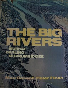
Book - The Big Rivers: Murray Darling Murrumbidgee, Max Colwell, 1978
... murray river (n.s.w.-s.a.)...murray river valley...Wodonga & District Historical Society Inc Hut 97, Bonegilla Migrant Experience, 132 Bonegilla Road Bonegilla the-murray murray river (n.s.w.-s.a.) murray river valley darling river murrumbidgee river description and travel nsw description and travel south australia A geography, description and travel guide to the "Big Rivers" of the Murray- Darling basin, including many photos of the region. ...A geography, description and travel guide to the "Big Rivers" of the Murray- Darling basin, including many photos of the region.non-fictionA geography, description and travel guide to the "Big Rivers" of the Murray- Darling basin, including many photos of the region.murray river (n.s.w.-s.a.), murray river valley, darling river, murrumbidgee river, description and travel nsw, description and travel south australia -
Koorie Heritage Trust
Book, Beveridge, Peter, The Aborigines of Victoria and Riverina, 2008 [i.e. 1889]
... | Aboriginal Australians -- Murray River Valley (N.S.W.-S.A.) | Aboriginals - Murray River vocabulary..... | Aboriginal Australians -- Murray River Valley (N.S.W.-S.A.) | Aboriginals - Murray River vocabulary. ...The Beveridge family of Tyntynder were early settlers. The author was in daily contact with the Aboriginals of the Swan Hill and Murray River tribes, acquired their language and learned much of their customs. His writings were published after his death and this volume contains illustrations from Smyth's Aborigines of Victoria and Garran's Picturesque Atlas of Australasia. It also has biographical notes on Peter Beveridge and others.xxxiv, 221 p. : ill. ; 21 cm.The Beveridge family of Tyntynder were early settlers. The author was in daily contact with the Aboriginals of the Swan Hill and Murray River tribes, acquired their language and learned much of their customs. His writings were published after his death and this volume contains illustrations from Smyth's Aborigines of Victoria and Garran's Picturesque Atlas of Australasia. It also has biographical notes on Peter Beveridge and others.aboriginal australians -- victoria. | aboriginal australians -- murray river valley (n.s.w.-s.a.) | aboriginals - murray river vocabulary. -
Koorie Heritage Trust
Book, Beveridge, Peter, The Aborigines of Victoria and Riverina, 1889
... | Aboriginal Australians -- Murray River Valley (N.S.W.-S.A.).... | Aboriginal Australians -- Murray River Valley (N.S.W.-S.A.) The author arrived in Victoria at the age of 10 years in 1839. ...The author arrived in Victoria at the age of 10 years in 1839. His family gave their name to the Victorian town. He and his brother settled at 'Tyntynder' outside Swan Hill in 1845. His brother was killed by Aborigines. Brought into daily contact with the Aborigines of the area he gradually acquired their language and was permitted to learn much denied to other whites. By 1883 he had amassed a large amount of information which he put into the form of a Paper, read before the Royal Society of New South Wales. This paper may be regarded as the skeleton of the volume now publishjed. Victoria -- Riverina Aboriginals, Victoria -Swan Hill region. Lifestyle; customs and beliefs. Tyntynder(Vic) Aboriginals - Murray River tribes; language; magic; religion and practices.191p.; vocab. list; The author arrived in Victoria at the age of 10 years in 1839. His family gave their name to the Victorian town. He and his brother settled at 'Tyntynder' outside Swan Hill in 1845. His brother was killed by Aborigines. Brought into daily contact with the Aborigines of the area he gradually acquired their language and was permitted to learn much denied to other whites. By 1883 he had amassed a large amount of information which he put into the form of a Paper, read before the Royal Society of New South Wales. This paper may be regarded as the skeleton of the volume now publishjed. Victoria -- Riverina Aboriginals, Victoria -Swan Hill region. Lifestyle; customs and beliefs. Tyntynder(Vic) Aboriginals - Murray River tribes; language; magic; religion and practices.aboriginal australians -- victoria. | aboriginal australians -- murray river valley (n.s.w.-s.a.) -
Koorie Heritage Trust
Book, Beauglehole, A. C, The distribution and conservation of vascular plants in the Murray Valley area, Victoria, 1986
... Botany -- Murray River Valley (N.S.W.-S.A.)...Koorie Heritage Trust Levels 1 & 3, Yarra Building Federation Square, Melbourne melbourne Botany -- Murray River Valley (N.S.W.-S.A.) ii, 81 p. : ill., maps ; 21 x 30 cm. + col. map. ...ii, 81 p. : ill., maps ; 21 x 30 cm. + col. map.botany -- murray river valley (n.s.w.-s.a.) -
Beechworth Honey Archive
Map- Albury/Wodonga
... Shows Albury and Wodonga, Murray River, Hume Highway, Murray Valley Highway and Riverina Highway. ...Shows Albury and Wodonga, Murray River, Hume Highway, Murray Valley Highway and Riverina Highway. ...(5x) Map centred on Albury and Wodonga. Shows Albury and Wodonga, Murray River, Hume Highway, Murray Valley Highway and Riverina Highway. Scale 1:50,000. Paper is white on back and yellow on front. Ca 1974-1975 Labelled 'Albury series R 652'map, albury, wodonga, paper, beechworth honey -
 Kiewa Valley Historical Society
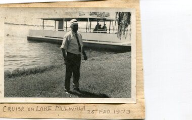
Photographs x 3- Cruise on Lake Mulwala, 25/2/1973
... Kiewa Valley Historical Society Mount Beauty Information Centre 31 Bogong High Plains Rd Mt Beauty high-country Lake Mulwala is a man–made reservoir created through the construction of the Yarrawonga Weir across the Murray River, is located between Bundalong and Yarrawonga in Hume region of Victoria and Mulwala in the Riverina region of New South Wales, in eastern Australia. ...Lake Mulwala is a man–made reservoir created through the construction of the Yarrawonga Weir across the Murray River, is located between Bundalong and Yarrawonga in Hume region of Victoria and Mulwala in the Riverina region of New South Wales, in eastern Australia. The weir was constructed in 1939 to provide water for irrigation of the surrounding district. The weir also serves as a crossing of the Murray between the two towns. It is a popular tourist destination for boating, fishing and other water recreation.Photographs demonstrate local Kiewa Valley residents enjoying a visit to the picturesque area of Lake Mulwala. Also provides a pictorial history of 1973.3 black and white photographs mounted on buff card. Photographs of a cruise on Lake Mulwala 25th Feb. 1973 1. Photo of unidentified man standing on the shore of Lake Mulwala beside cruise launch. 2. Group photo of people standing by cruise boat as others disembark. Woman in centre holding handbag may be Clare Roper (unconfirmed) 3. Photo of 2 men aboard cruise launch looking out over Lake Mulwala1. Handwritten at bottom of photo in black ink. 'Cruise on Lake Mulwala. 25th Feb. 1973' 2. Painted sign above cruise launch- Scenic Lake Cruises 3. No markingsclare roper -
 Kiewa Valley Historical Society
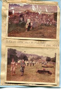
Photographs x 2- D Reids home at Mill Park 1973, 2/12/1973
... Kiewa Valley Historical Society Mount Beauty Information Centre 31 Bogong High Plains Rd Mt Beauty high-country David Reid (1820-1906) was a pastoralists and politician. He left school at 16 and after meeting the overlander John Gardiner he decided to look for land south of the Murray River. ...David Reid (1820-1906) was a pastoralists and politician. He left school at 16 and after meeting the overlander John Gardiner he decided to look for land south of the Murray River. Equipped by his father with some 500 head of cattle, 2 bullock wagons and teams and 6 assigned servants, he reached the Ovens River on 8 September 1838. David settled at Currargarmonge, near Wangaratta. At the end of 1843 he took up land near Yackandandah. In 1847 he took up a section of the family run of which Woorajay (Wooragee) formed a part. He built the first water driven flour-mill in the district on his Yackandandah run in 1845; his woolclip of 1848 was one of the first to be handled by R. Goldsbrough and was claimed to come from sheep descended from stock imported in the 1820s from George III's flock. Going into politics, he held the Legislative Assembly seat of Murray from October 1859 to May 1862. David Reid was a highly regarded grazier and local politician who was significantly involved in settlement around the Yackandandah area. Photo demonstrates ongoing interest in the local history of the area and its early residents2 colour photographs mounted together on buff card 1. Man and 2 children (unidentified) standing outside the remains of the Reid home. 2 Dec, 1973 2. Group of unidentified people on a tour of the old homestead of D. Reid. 2 Dec, 19731. Handwritten in black ink under photo 'D. Reid's home 1845. At Mill Park. 2 Dec 1973 2. Handwritten in blue ink under photo 'Snapshots Clare Roper"clare roper -
 Kiewa Valley Historical Society
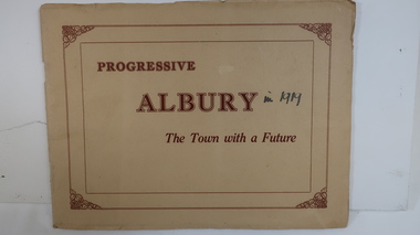
Book - Albury, NSW, Progressive Albury The Town with a Future
... Kiewa Valley Historical Society Mount Beauty Information Centre 31 Bogong High Plains Rd Mt Beauty high-country Albury is in NSW on the Murray River across the border from Wodonga. ...Albury is in NSW on the Murray River across the border from Wodonga. From 1839 it has grown and has a population of c8000 in 1919. Many of its buildings are grand and include 'Mates' a 'progressive up-to-date' Department Store.Residents of the Kiewa Valley shop in Albury and Wodonga as together these are their closest main cities.Cream cardboard cover with reddish print inside rectangular border with grape decoration in each corner. 20 pages held by 2 staples. Each page has 1 or 2 black and white photos. Photos have their title printed underneath.On cover - "in 1919"albury, shopping, murray river, mates department store, grand buildings -
 Kiewa Valley Historical Society
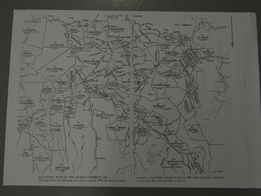
Maps - Squatting Runs of the Murray District 1848 x2, July 26,1848
... Valley Historical Society Mount Beauty Information Centre 31 Bogong High Plains Rd Mt Beauty high-country The Port Phillip Gazette was the second newspaper published in Melbourne, in the then Port Phillip district, now Victoria. In 1948 it was published bi-weekly. The map shows the original names of squatters along the Kiewa River. The names of the district are mostly current today although some are spelt differently. Squatting Runs; Kiewa Valley; Port Phillip District; 2 copies - 1 laminated & 1 paper of the map of "Squatting Runs of the Murray ...The Port Phillip Gazette was the second newspaper published in Melbourne, in the then Port Phillip district, now Victoria. In 1948 it was published bi-weekly.The map shows the original names of squatters along the Kiewa River. The names of the district are mostly current today although some are spelt differently.2 copies - 1 laminated & 1 paper of the map of "Squatting Runs of the Murray District 1848." The area is recorded (eg. Tawanga, Dederang, Gundowring, Kergunia, Merrimarenbung all along the Kiewa River) under which the names of the squatter is recorded, the number of acres and the licence number. Scale is 8 miles to the inch.squatting runs; kiewa valley; port phillip district; -
 Kiewa Valley Historical Society
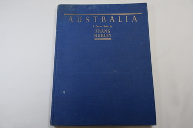
Book - Book- Photos, Australia - A Camera Study by / Frank / Hurley
... Valley Historical Society Mount Beauty Information Centre 31 Bogong High Plains Rd Mt Beauty high-country Frank Hurley (1885-1962) was an Australian photographer and adventurer. He participated in trips to Antartica and was an official photographer with the Australian forces during both world wars. This book was first published in 1955. Photographs include the Hume Reservoir, Mt Buffalo and the Alpine High Country of Mt Kosciusko. (pages 140-144) All are associated with the type of country at each end of the Kiewa River. The Kiewa River flows into the Murray ...Frank Hurley (1885-1962) was an Australian photographer and adventurer. He participated in trips to Antartica and was an official photographer with the Australian forces during both world wars. This book was first published in 1955.Photographs include the Hume Reservoir, Mt Buffalo and the Alpine High Country of Mt Kosciusko. (pages 140-144) All are associated with the type of country at each end of the Kiewa River. The Kiewa River flows into the Murray River just below the Hume Dam and Mt Buffalo and Mt Kosciusko are part of the Alpine High country near the Bogong High Plains. Clare Roper lived on a farm in the Kiewa Valley.Blue hard cover, bound book with the title in gold at the top. 208 pages. Mostly Black & white photos but some coloured.Inside back of first page - written 'Clare Roper'frank hurley photographer, australian photography, clare roper -
 Kiewa Valley Historical Society
Reel Fishing, Circa 1920's to 1940's
... Murray Cod and trout in the Kiewa Rivers and Murray River. This old Pilot side cast fishing reel was made in the late 20's & early 30's They were used in the mid 1950s. Although the original inhabitants (Aborigine tribe) would have used spears for fishing the use of reels and rods by non indigenous fisher persons are also very effective especially if raised in the valley....Kiewa Valley Historical Society Mount Beauty Information Centre 31 Bogong High Plains Rd Mt Beauty high-country These reels where used by a local family in catching Murray Cod and trout in the Kiewa Rivers and Murray River. ...These reels where used by a local family in catching Murray Cod and trout in the Kiewa Rivers and Murray River. This old Pilot side cast fishing reel was made in the late 20's & early 30's They were used in the mid 1950s. Although the original inhabitants (Aborigine tribe) would have used spears for fishing the use of reels and rods by non indigenous fisher persons are also very effective especially if raised in the valley.These items are significant because they demonstrate the harvesting of fish from valley rivers and streams is one of continuation from the first human habitation of this region. The ability to harvest the natural food source of the valley's rivers and streams has come from earlier survival requirement to one of recreational pleasure. Brass & Wooden Frame Side Casting Fishing Reel. This reel has 2 winding bakelite handles.Pilot, Tag states W. Davies Please return.recreation, river, kiewa, fishing, industry, reel, side, casting, davies -
Marysville & District Historical Society
THE TRIANGLE NEWS-VOL 37 NO 36-OCTOBER 1 2010
... Marysville & District Historical Society 39 Darwin Street Marysville yarra-valley-and-the-dandenong-ranges marysville victoria australia national water week goulburn-murray water shepparton water treatment river to tap tour alexandra goulburn broken catchment donation to yea community murrindindi shire council THE TRIANGLE NEWS-VOL 37 NO 36-OCTOBER 1 2010 ...marysville, victoria, australia, national water week, goulburn-murray water, shepparton water treatment, river to tap tour alexandra, goulburn broken catchment, donation to yea community, murrindindi shire council -
 Orbost & District Historical Society
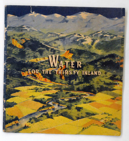
book, Water For the Thirsty Inland, 1945
... Water For the Thirsty Inland was published by The Murrumbidgee Valley Water Users Association as a case for diversion of part of the Snowy River waters to the Murrumbidgee. In 1950 The Murrumbidgee Valley Water Users Association and the League established the Murray-Murrumbidgee Development Committee to ensure the Snowy Scheme was completed....Orbost & District Historical Society Ruskin Street Orbost gippsland Water For the Thirsty Inland was published by The Murrumbidgee Valley Water Users Association as a case for diversion of part of the Snowy River waters to the Murrumbidgee. In 1950 The Murrumbidgee Valley Water Users Association and the League established the Murray-Murrumbidgee Development Committee to ensure the Snowy Scheme was completed. ...Water For the Thirsty Inland was published by The Murrumbidgee Valley Water Users Association as a case for diversion of part of the Snowy River waters to the Murrumbidgee. In 1950 The Murrumbidgee Valley Water Users Association and the League established the Murray-Murrumbidgee Development Committee to ensure the Snowy Scheme was completed.This book is a significant research tool for the history of the diversion of the Snowy River.A 44 pp book, titled Water For The Thirsty Inland. On the front cover is a coloured print of a painting of a river (Snowy River?) from the mountains to the flats. The text of the title is white with a black shadow. The book contains b/w photographs and the print is black and green.Some pencilled notes on back.snowy-river murrumbidgee-valley-water-users' irrigation -
Eltham District Historical Society Inc
Document - Folder, Oyston, Peter
... Murray River Performing Group, The Flying Fruit Fly Circus, West Theatre and Theatreworks. He taught at the Royal Academy of Dramatic Art in London and directed more than 200 productions in Australia and other countries. He had one daughter. Contents Newspaper article: "Director takes his curtain call", Diamond Valley...Murray River Performing Group, The Flying Fruit Fly Circus, West Theatre and Theatreworks. He taught at the Royal Academy of Dramatic Art in London and directed more than 200 productions in Australia and other countries. He had one daughter. Contents Newspaper article: "Director takes his curtain call", Diamond Valley ...Peter Oyston died in 2011. His career included being Founding Dean of drama at the Victorian College the Arts and director of Playbox Theatre. He was a champion of theatre companies including The Murray River Performing Group, The Flying Fruit Fly Circus, West Theatre and Theatreworks. He taught at the Royal Academy of Dramatic Art in London and directed more than 200 productions in Australia and other countries. He had one daughter. Contents Newspaper article: "Director takes his curtain call", Diamond Valley Leader, 19 October 2011, Obituary of Peter Oyston.Newspaper clippings, A4 photocopies, etcpeter oyston, victorian college of the arts, bend of islands, playbox theatre, the fying fruit fly circus, theatreworks, royal academy of dramatic arts london, dominque oyston, ray mooney, west theatre, the murray river performing group -
 Eltham District Historical Society Inc
Document - Property Binder, 559 Main Road, Eltham
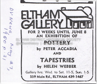
... Valley News, Tuesday, July 8, 1986, p27; exhibition of five artists at Eltham Gallery. On reverse, numerous advertisements for food and entertainment Newspaper advertisement: The Age ,17 June 1989, Exhibition, Donald Ramsay "Watching the river flow". Newspaper article: Landmark gallery says goodbye, Diamond Valley Leader, 24 November 2004, Gallery site sold to Sentinel Equities, present tenant Julie Skate, quotes from former part-owner Val Murray. ...Valley News, Tuesday, July 8, 1986, p27; exhibition of five artists at Eltham Gallery. On reverse, numerous advertisements for food and entertainment Newspaper advertisement: The Age ,17 June 1989, Exhibition, Donald Ramsay "Watching the river flow". Newspaper article: Landmark gallery says goodbye, Diamond Valley Leader, 24 November 2004, Gallery site sold to Sentinel Equities, present tenant Julie Skate, quotes from former part-owner Val Murray. ...Newspaper advertisement: Diamond Valley News, 27 May 1980, Exhibition, Peter Accadia, pottery, and Helen Webber, tapestries. Newspaper article: Five for the price of one, Diamond Valley News, Tuesday, July 8, 1986, p27; exhibition of five artists at Eltham Gallery. On reverse, numerous advertisements for food and entertainment Newspaper advertisement: The Age ,17 June 1989, Exhibition, Donald Ramsay "Watching the river flow". Newspaper article: Landmark gallery says goodbye, Diamond Valley Leader, 24 November 2004, Gallery site sold to Sentinel Equities, present tenant Julie Skate, quotes from former part-owner Val Murray. Newspaper article: Rift over gallery plans, Diamond Valley Leader, 21 February 2007, purchasers Jethro Tull and Suzanne Still plan to build offices, gallery and cafe; Eltham Gateway Action Group objected while supporting need for a gallery elsewhere. Newspaper article: New try for gallery-cafe ready soon, Diamond Valley Leader, 18 April 2007, purchaser Jethro Tull to have a new plan ready in two weeks for gallery and cafe. Newspaper article: Gateway for artists, Diamond Valley Leader, 25 May 2007, Jenni Mitchell opened a new gallery pending decision by Nillumbik Council. Newspaper article: Art gallery proposal rejected, Diamond Valley Leader, 30 May 2007, Nillumbik Council against planned new building. Newspaper article: Artful win for gallery, Diamond Valley Leader, 30 January 2008, VCAT approved mudbrick art gallery. Newspaper article: Rocky road to create a landmark, Diamond Valley Leader, 13 February 2008, VCAT approved Robert Marshall's design, artists's impression, Eltham Gateway Action Group opposed.main road, property, businesses, eltham gallery, wiregrass gallery, eltham gateway action group, robert marshall, mud brick building, eltham (vic), 559 main road eltham, artists, bernhard rust, bob smith, jan neil, john adams, marian sussex, michael wilson, tony dopheide, 47-55 main street diamond creek, 50 were street montmorency, 55 rattray road montmorency, 410 main road lower plenty, abbey of diamond creek, adams north riding restaurant, advertising, eltham barrel, montmorency, mustard seed restaurant, peking house restaurant, st andrews, tamara's -
 Marysville & District Historical Society
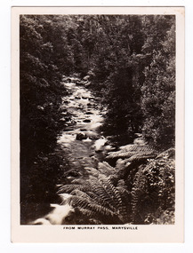
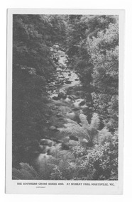
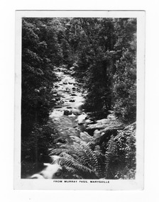
Photograph (item) - Black and white photograph, Rose Stereograph Company, From Murray Pass, Marysville, 1913-1967
... Marysville & District Historical Society 39 Darwin Street Marysville yarra-valley-and-the-dandenong-ranges An early black and white photograph of the Taggerty River from Murray Pass near Marysville, Victoria. ...An early black and white photograph of the Taggerty River from Murray Pass near Marysville, Victoria.An early black and white photograph of the Taggerty River from Murray Pass near Marysville, Victoria. Murray Pass is off the Lady Talbot Drive. Lady Talbot Drive a 24 kilometer scenic rainforest car journey which passes a number of walks and waterfalls in the Yarra Ranges National Park. Lady Talbot Drive is named after Lady Sarah Elizabeth, the wife of Sir Reginald Talbot, who was the Governor of Victoria from 25th April, 1904 to 6th July 1908.The photograph was also used to produce the Rose Series postcard P. 2309.marysville, victoria, photograph, taggerty river, murray pass, lady talbot forest drive, p. 2309, rose series postcard, souvenir, rose stereograph company, sir reginald talbot, lady sarah elizabeth talbot -
 Marysville & District Historical Society
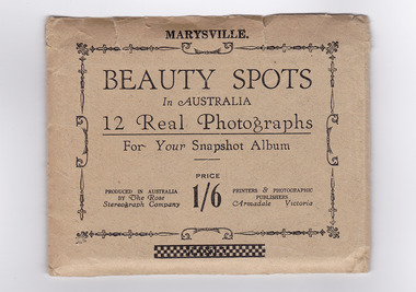
Photograph (item) - Black and white photographs, Rose Stereograph Company, Beauty Spots In Australia-Marysville, 1913-1967
... valley-and-the-dandenong-ranges An envelope with 12 black and white photographs of scenic attractions taken in and around Marysville in Victoria. The photographs were used for a series of photographs and postcards published by the Rose Stereograph Company in Armadale, Victoria. An envelope with photographs of scenic attractions taken in and around Marysville in Victoria. keppel falls (image 1) cumberland falls (image 2) track to cora lynn falls (image 3) nichol's lookout (image 4) cameron cascades (image 5) stevenson falls (image 6) taggerty river (image 7) main street (image 8) glover walk (image 9) from murray pass (image 10) cora lynn falls (image 11) taggerty river (image 12) rose series postcard rose stereograph company souvenir 12 Real Photographs/ For Your Snapshot Album PRODUCED IN AUSTRALIA/ BY The Rose/ Stereograph Company PRINTERS & PHOTOGRAPHIC/ PUBLISHERS/ Armadale, Victoria PRICE/ 1/6 An envelope with 12 black and white photographs of scenic attractions taken in and around Marysville in Victoria. ...An envelope with 12 black and white photographs of scenic attractions taken in and around Marysville in Victoria. The photographs were used for a series of photographs and postcards published by the Rose Stereograph Company in Armadale, Victoria.An envelope with photographs of scenic attractions taken in and around Marysville in Victoria.12 Real Photographs/ For Your Snapshot Album PRODUCED IN AUSTRALIA/ BY The Rose/ Stereograph Company PRINTERS & PHOTOGRAPHIC/ PUBLISHERS/ Armadale, Victoria PRICE/ 1/6keppel falls (image 1), cumberland falls (image 2), track to cora lynn falls (image 3), nichol's lookout (image 4), cameron cascades (image 5), stevenson falls (image 6), taggerty river (image 7), main street (image 8), glover walk (image 9), from murray pass (image 10), cora lynn falls (image 11), taggerty river (image 12), rose series postcard, rose stereograph company, souvenir -
 Marysville & District Historical Society
Postcard (item) - Black and white postcard, Rose Stereograph Company, At Murray Pass, Marysville, 1913-1967
... Marysville & District Historical Society 39 Darwin Street Marysville yarra-valley-and-the-dandenong-ranges A postcard in a series produced by the Rose Stereograph Company in Victoria, Australia as a souvenir of Marysville. An early black and white photograph of the Taggerty River from Murray Pass near Marysville, Victoria. ...A postcard in a series produced by the Rose Stereograph Company in Victoria, Australia as a souvenir of Marysville.An early black and white photograph of the Taggerty River from Murray Pass near Marysville, Victoria. Murray Pass is located on the Lady Talbot Drive. Lady Talbot Drive a 24 kilometer scenic rainforest car journey which passes a number of walks and waterfalls in the Yarra Ranges National Park. Lady Talbot Drive is named after Lady Sarah Elizabeth, the wife of Sir Reginald Talbot, who was the Governor of Victoria from 25th April, 1904 to 6th July 1908. This postcard was produced by the Rose Stereograph Company as a souvenir of Marysville.SOUTHERN CROSS SERIES 2309/ COPYRIGHT/ AT MURRAY PASS, MARYSVILLE, VIC. POST CARD. Correspondence Addressmarysville, victoria, photograph, taggerty river, murray pass, lady talbot forest drive, southern cross series, 2309, postcard, souvenir, lady talbot drive, sir reginald talbot, sarah elizabeth talbot -
 Marysville & District Historical Society
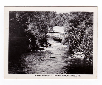
Photograph (item) - Black and white photograph, Murray Views, Murray Views No. 11. Taggerty River, Marysville, Vic, Post 1929
... valley-and-the-dandenong-ranges An early black and white photograph of the Steavenson River in Marysville, Victoria. An early black and white photograph of the Steavenson River in Marysville, Victoria. The Steavenson Falls is named after the Victorian Assistant Commissioner of Roads and Bridges, John Steavenson who arrived here in the early 1860s. This photograph was published by Murray ...An early black and white photograph of the Steavenson River in Marysville, Victoria.An early black and white photograph of the Steavenson River in Marysville, Victoria. The Steavenson Falls is named after the Victorian Assistant Commissioner of Roads and Bridges, John Steavenson who arrived here in the early 1860s. This photograph was published by Murray Views in Gympie, Queensland, as a souvenir of Marysville.marysville, victoria, photograph, murray views, souvenir, steavenson river, john steavenson -
 Marysville & District Historical Society
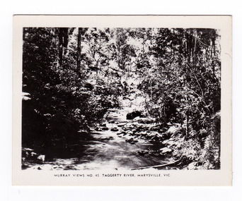
Photograph (item) - Black and white photograph, Murray Views, Murray Views No. 45. Taggerty River, Marysville, Vic, Post 1929
... Marysville & District Historical Society 39 Darwin Street Marysville yarra-valley-and-the-dandenong-ranges An early black and white photograph of the Taggerty River in Marysville, Victoria. An early black and white photograph of the Taggerty River in Marysville, Victoria. This photograph was produced by Murray ...An early black and white photograph of the Taggerty River in Marysville, Victoria. An early black and white photograph of the Taggerty River in Marysville, Victoria. This photograph was produced by Murray Views in Gympie, Queensland as a souvenir of Marysville.taggerty river, marysville, victoria, murray views, photograph, souvenir -
 Marysville & District Historical Society
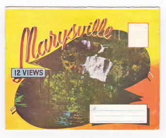
Postcard (item) - Colour photographs, Murray Views, Marysville 12 Views, 1950's
... river (image 3)...fruit salad farm (image 4)...main street marysville (image 5)...road scene marysville (image 6)...the crossways (image 7)...cumberland valley (image 8)...black spur (image 9)...nicholl's lookout (image 10)...tree ferns (image 11)...bridge (image 12)...marysville...victoria...postcard...souvenir...murray...valley-and-the-dandenong-ranges A fold out postcard of 12 colour photographs of scenes and landscapes in and around Marysville in Victoria. A fold out postcard 12 colour photographs of scenes and landscapes in and around Marysville in Victoria. These photographs were produced by Murray Views in Gympie, Queensland as a souvenir of Marysville. steavenson falls (image 1) tourists in marysville (image 2) taggerty river (image 3) fruit salad farm (image 4) main street marysville (image 5) road scene marysville (image 6) the crossways (image 7) cumberland valley (image 8) black spur (image 9) nicholl's lookout (image 10) tree ferns (image 11) bridge (image 12) marysville victoria postcard souvenir murray views Marysville/ 12 VIEWS PRODUCED BY MURRAY VIEWS./ GYMPIE./ Q COPYRIGHT SAMUEL LEE & CO., PRINTERS. ...A fold out postcard of 12 colour photographs of scenes and landscapes in and around Marysville in Victoria.A fold out postcard 12 colour photographs of scenes and landscapes in and around Marysville in Victoria. These photographs were produced by Murray Views in Gympie, Queensland as a souvenir of Marysville.Marysville/ 12 VIEWS PRODUCED BY MURRAY VIEWS./ GYMPIE./ Q COPYRIGHT SAMUEL LEE & CO., PRINTERS. STEAVENSON'S FALLS, MARYSVILLE, VIC. TOURISTS AT MARYSVILLE, VIC. "FRUIT SALAD FARM", MARYSVILLE MAIN STREET, MARYSVILLE, VIC. ROAD SCENE, MARYSVILLE, VIC. THE CROSSWAYS, MARYSVILLE, VIC ROAD TO CUMBERLAND VALLEY, MARYSVILLE PANORAMA FROM BLACK SPUR, MARYSVILLE ROAD, MARYSVILLE, VIC. NICHOLL'S LOOKOUT, MARYSVILLE, VIC. TREE FERNS, MARYSVILLE, VIC. THE BRIDGE, MARYSVILLE, VIC.steavenson falls (image 1), tourists in marysville (image 2), taggerty river (image 3), fruit salad farm (image 4), main street marysville (image 5), road scene marysville (image 6), the crossways (image 7), cumberland valley (image 8), black spur (image 9), nicholl's lookout (image 10), tree ferns (image 11), bridge (image 12), marysville, victoria, postcard, souvenir, murray views -
 Marysville & District Historical Society
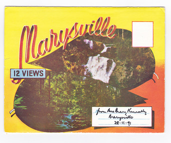
Postcard (item) - Colour photographs, Murray Views, Marysville 12 Views, 1950's
... river (image 3)...fruit salad farm (image 4)...main street marysville (image 5)...road scene marysville (image 6)...the crossways (image 7)...cumberland valley (image 8)...black spur (image 9)...nicholl's lookout (image 10)...tree ferns (image 11)...bridge (image 12)...marysville...victoria...postcard...souvenir...murray...valley-and-the-dandenong-ranges A fold out postcard of 12 colour photographs of scenes and landscapes in and around Marysville in Victoria. A fold out postcard 12 colour photographs of scenes and landscapes in and around Marysville in Victoria. These photographs were produced by Murray Views in Gympie, Queensland as a souvenir of Marysville. steavenson falls (image 1) tourists in marysville (image 2) taggerty river (image 3) fruit salad farm (image 4) main street marysville (image 5) road scene marysville (image 6) the crossways (image 7) cumberland valley (image 8) black spur (image 9) nicholl's lookout (image 10) tree ferns (image 11) bridge (image 12) marysville victoria postcard souvenir murray views Marysville/ 12 VIEWS from Mrs Mary Keneally/ Marysville/ 28.11.91 PRODUCED BY MURRAY VIEWS./ GYMPIE./ Q COPYRIGHT SAMUEL LEE & CO., PRINTERS. ...A fold out postcard of 12 colour photographs of scenes and landscapes in and around Marysville in Victoria.A fold out postcard 12 colour photographs of scenes and landscapes in and around Marysville in Victoria. These photographs were produced by Murray Views in Gympie, Queensland as a souvenir of Marysville.Marysville/ 12 VIEWS from Mrs Mary Keneally/ Marysville/ 28.11.91 PRODUCED BY MURRAY VIEWS./ GYMPIE./ Q COPYRIGHT SAMUEL LEE & CO., PRINTERS. STEAVENSON'S FALLS, MARYSVILLE, VIC. TOURISTS AT MARYSVILLE, VIC. "FRUIT SALAD FARM", MARYSVILLE MAIN STREET, MARYSVILLE, VIC. ROAD SCENE, MARYSVILLE, VIC. THE CROSSWAYS, MARYSVILLE, VIC ROAD TO CUMBERLAND VALLEY, MARYSVILLE PANORAMA FROM BLACK SPUR, MARYSVILLE ROAD, MARYSVILLE, VIC. NICHOLL'S LOOKOUT, MARYSVILLE, VIC. TREE FERNS, MARYSVILLE, VIC. THE BRIDGE, MARYSVILLE, VIC.steavenson falls (image 1), tourists in marysville (image 2), taggerty river (image 3), fruit salad farm (image 4), main street marysville (image 5), road scene marysville (image 6), the crossways (image 7), cumberland valley (image 8), black spur (image 9), nicholl's lookout (image 10), tree ferns (image 11), bridge (image 12), marysville, victoria, postcard, souvenir, murray views -
 Marysville & District Historical Society
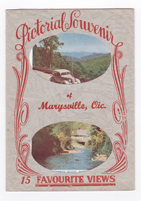
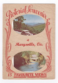
Postcard (item) - Colour and black and white photographs, Murray Views, Pictorial Souvenur of Marysville, Vic. 15 Favourite Views, 1950's
... MURRAY VIEWS. GYMPIE. Q. COPYRIGHT SAMUEL LEE & CO., PRINTERS Serial No. R 4152 NICHOLL'S LOOKOUT, MARYSVILLE, VIC. TAGGERTY RIVER, MARYSVILLE, VIC ROAD SCENE, MARYSVILLE, VIC. MAIN STREET, MARYSVILLE, VIC. THE CROSSWAYS, MARYSVILLE, VIC. FRUIT SALAD FARM, MARYSVILLE, VIC. ROAD TO CUMBERLAND VALLEY... (image 2) road scene (image 3) main street marysville (image 4) crossways hotel (image 5) fruit salad farm (image 6) cumberland valley (image 7) crossways cabaret (image 8) tree ferns (image 9) steavenson falls (image 10) marysville view (image 11) tourists marysville (image 12) taggerty river (image 13) buxton road (image 14) black spur (image 15) Pictorial Souvenir/ of/ Marysville, Vic./ 15 Favourite Views PRODUCED BY MURRAY VIEWS. ...A fold out postcard of 15 colour and black and white photographs of scenes and landscapes in and around Marysville in Victoria.A fold out postcard of 15 colour and black and white photographs of scenes and landscapes in and around Marysville in Victoria. These photographs were produced by Murray Views in Gympie, Queensland as a souvenir of Marysville.Pictorial Souvenir/ of/ Marysville, Vic./ 15 Favourite Views PRODUCED BY MURRAY VIEWS. GYMPIE. Q. COPYRIGHT SAMUEL LEE & CO., PRINTERS Serial No. R 4152 NICHOLL'S LOOKOUT, MARYSVILLE, VIC. TAGGERTY RIVER, MARYSVILLE, VIC ROAD SCENE, MARYSVILLE, VIC. MAIN STREET, MARYSVILLE, VIC. THE CROSSWAYS, MARYSVILLE, VIC. FRUIT SALAD FARM, MARYSVILLE, VIC. ROAD TO CUMBERLAND VALLEY, MARYSVILLE, VIC. CROSSWAYS CABARET, MARYSVILLE, VIC. TREE FERNS, MARYSVILLE, VIC. STEVENSON'S FALLS, MARYSVILLE, VIC. Looking towards Marysville, Vic. Tourists at Marysville, Vic. Taggerty River, Marysville, Vic. On Buxton Road, Marysville, Vic. Panorama from Black Spur, Marysville Road, Marysville, Vic.marysville, victoria, souvenir, postcard, nicholl's lookout (image 1), taggerty river (image 2), road scene (image 3), main street marysville (image 4), crossways hotel (image 5), fruit salad farm (image 6), cumberland valley (image 7), crossways cabaret (image 8), tree ferns (image 9), steavenson falls (image 10), marysville view (image 11), tourists marysville (image 12), taggerty river (image 13), buxton road (image 14), black spur (image 15) -
 Marysville & District Historical Society
Postcard (item) - Colour and black and white photographs, Pictorial Souvenir of Marysville, Vic. 15 Favourite Views
... MURRAY VIEWS. GYMPIE. Q. COPYRIGHT SAMUEL LEE & CO., PRINTERS Serial No. R 4152 NICHOLL'S LOOKOUT, MARYSVILLE, VIC. TAGGERTY RIVER, MARYSVILLE, VIC ROAD SCENE, MARYSVILLE, VIC. MAIN STREET, MARYSVILLE, VIC. THE CROSSWAYS, MARYSVILLE, VIC. FRUIT SALAD FARM, MARYSVILLE, VIC. ROAD TO CUMBERLAND VALLEY... (image 2) road scene (image 3) main street marysville (image 4) crossways hotel (image 5) fruit salad farm (image 6) cumberland valley (image 7) crossways cabaret (image 8) tree ferns (image 9) steavenson falls (image 10) marysville view (image 11) tourists marysville (image 12) taggerty river (image 13) buxton road (image 14) black spur (image 15) Pictorial Souvenir/ of/ Marysville, Vic./ 15 Favourite Views PRODUCED BY MURRAY VIEWS. ...A fold out postcard of 15 colour and black and white photographs of scenes and landscapes in and around Marysville in Victoria.A fold out postcard of 15 colour and black and white photographs of scenes and landscapes in and around Marysville in Victoria. These photographs were produced by Murray Views in Gympie, Queensland as a souvenir of Marysville.Pictorial Souvenir/ of/ Marysville, Vic./ 15 Favourite Views PRODUCED BY MURRAY VIEWS. GYMPIE. Q. COPYRIGHT SAMUEL LEE & CO., PRINTERS Serial No. R 4152 NICHOLL'S LOOKOUT, MARYSVILLE, VIC. TAGGERTY RIVER, MARYSVILLE, VIC ROAD SCENE, MARYSVILLE, VIC. MAIN STREET, MARYSVILLE, VIC. THE CROSSWAYS, MARYSVILLE, VIC. FRUIT SALAD FARM, MARYSVILLE, VIC. ROAD TO CUMBERLAND VALLEY, MARYSVILLE, VIC. CROSSWAYS CABARET, MARYSVILLE, VIC. TREE FERNS, MARYSVILLE, VIC. STEVENSON'S FALLS, MARYSVILLE, VIC. Looking towards Marysville, Vic. Tourists at Marysville, Vic. Taggerty River, Marysville, Vic. On Buxton Road, Marysville, Vic. Panorama from Black Spur, Marysville Road, Marysville, Vic.marysville, victoria, souvenir, postcard, nicholl's lookout (image 1), taggerty river (image 2), road scene (image 3), main street marysville (image 4), crossways hotel (image 5), fruit salad farm (image 6), cumberland valley (image 7), crossways cabaret (image 8), tree ferns (image 9), steavenson falls (image 10), marysville view (image 11), tourists marysville (image 12), taggerty river (image 13), buxton road (image 14), black spur (image 15) -
 Marysville & District Historical Society
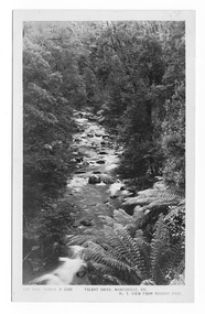
Postcard (item) - Black and white postcard, Rose Stereograph Company, Talbot Drive, Marysville, Vic. No. 4, View from Murray Pass, 1913-1967
... Marysville & District Historical Society 39 Darwin Street Marysville yarra-valley-and-the-dandenong-ranges An early black and white photograph of the view of the Taggerty River from Murray Pass near Marysville in Victoria. ...An early black and white photograph of the view of the Taggerty River from Murray Pass near Marysville in Victoria.An early black and white photograph of the Taggerty River from Murray Pass near Marysville, Victoria. Murray Pass is located on the Lady Talbot Drive. Lady Talbot Drive a 24 kilometer scenic rainforest car journey which passes a number of walks and waterfalls in the Yarra Ranges National Park. Lady Talbot Drive is named after Lady Sarah Elizabeth, the wife of Sir Reginald Talbot, who was the Governor of Victoria from 25th April, 1904 to 6th July 1908. This postcard was produced by the Rose Stereograph Company as a souvenir of Marysville.POST CARD The "Rose" Series/ De Luxe A Real Photograph/ Produced in Australia Published by the Rose Stereograph Co./ Armadale, Victoria. Dear Harold/ This is the prettiest card I/ could get for you. Probably we will/ go this trip in a day or two./ Yours Nance xxx xxxmarysville, victoria, photograph, taggerty river, murray pass, lady talbot forest drive, 2309, postcard, souvenir, lady talbot drive, sir reginald talbot, sarah elizabeth talbot, rose series postcard -
 Marysville & District Historical Society
Postcard (item) - Black and white postcard, Rose Stereograph Company, At Murray Pass, Marysville, Vic, 1913-1967
... Marysville & District Historical Society 39 Darwin Street Marysville yarra-valley-and-the-dandenong-ranges A postcard in a series produced by the Rose Stereograph Company in Victoria, Australia as a souvenir of Marysville. An early black and white photograph of the Taggerty River from Murray Pass near Marysville, Victoria. ...A postcard in a series produced by the Rose Stereograph Company in Victoria, Australia as a souvenir of Marysville.An early black and white photograph of the Taggerty River from Murray Pass near Marysville, Victoria. Murray Pass is located on the Lady Talbot Drive. Lady Talbot Drive a 24 kilometer scenic rainforest car journey which passes a number of walks and waterfalls in the Yarra Ranges National Park. Lady Talbot Drive is named after Lady Sarah Elizabeth, the wife of Sir Reginald Talbot, who was the Governor of Victoria from 25th April, 1904 to 6th July 1908. This postcard was produced by the Rose Stereograph Company as a souvenir of Marysville.POST CARD. Correspondence Addressmarysville, victoria, photograph, taggerty river, murray pass, lady talbot forest drive, southern cross series, 2309, postcard, souvenir, lady talbot drive, sir reginald talbot, sarah elizabeth talbot -
 Marysville & District Historical Society
Photograph (item) - Black and white photograph, Rose Stereograph Company, From Murray Pass, Marysville, 1913-1967
... Marysville & District Historical Society 39 Darwin Street Marysville yarra-valley-and-the-dandenong-ranges An early black and white photograph of the Taggerty River from Murray Pass near Marysville, Victoria. ...An early black and white photograph of the Taggerty River from Murray Pass near Marysville, Victoria.An early black and white photograph of the Taggerty River from Murray Pass near Marysville, Victoria. Murray Pass is off the Lady Talbot Drive. Lady Talbot Drive a 24 kilometer scenic rainforest car journey which passes a number of walks and waterfalls in the Yarra Ranges National Park. Lady Talbot Drive is named after Lady Sarah Elizabeth, the wife of Sir Reginald Talbot, who was the Governor of Victoria from 25th April, 1904 to 6th July 1908.The photograph was also used to produce the Rose Series postcard P. 2309.marysville, victoria, photograph, taggerty river, murray pass, lady talbot forest drive, p. 2309, rose series postcard, souvenir, rose stereograph company, sir reginald talbot, lady sarah elizabeth talbot -
Marysville & District Historical Society
Article (item) - Book Extract, Aboriginal History, Unknown
... valley...kilmore...mount william...jt gellibrand...william buckley...major mitchell...port phillip...murray river...The extract also covers current (1991) status of Aboriginal affairs and European settlement of the area. kulin nation woiworung taungurong bunurong watherong jajowrong wurrundjeri-willam waring-ilam-balluk goulburn valley acheron valley upper goulburn district eildon-thornton eildon homestead o'rourke thornton assistant protector thomas yarra valley kilmore mount william jt gellibrand william buckley major mitchell port phillip murray river yorta yorta yowung-illam-balluk waring-illam-balluk ngurai-illam-wurrung kurnai nation protectorate system victoria george robinson chief protector willam thomas james dredge edward parker charles sievewright central board for the protection of aborigines presbyterian mission anglican mission moravian mission wonga munnarin beaning murrin murrin parugean baruppin koo-gurrin acheron river little river acheron run peter snodgrass stephen jones barak dividing range black spur watts river badger creek healesville coranderrk victorian christmas bush aboriginal and torres strait islander heritage protection act 1984 archaelological and aboriginal relics preservation act 1972 camp jungai rubicon warrawa college victorian archaeological survey hume and hovell molesworth broadford william hamilton alexandra mansfield avenel tallarook worrough john cotton trawool valley seymour pyalong gold mining central victoria strath creek reedy creek yea jamieson marysville jordan goldfields comet mine wandong melbourne-albury railway rabbit plague narbethong lord kitchener puckapunyal military camp 1944 decentralisation policy eildon weir hume freeway bypass timber industry australian paper manufacturers mill An extract from a book regarding a brief history of the Kulin nation of the North Central district of Victoria. ...An extract from a book regarding a brief history of the Kulin nation of the North Central district of Victoria.An extract from a book regarding a brief history of the Kulin nation of the North Central district of Victoria. This history covered is both prior to European history and post-European history. The extract also covers current (1991) status of Aboriginal affairs and European settlement of the area.kulin nation, woiworung, taungurong, bunurong, watherong, jajowrong, wurrundjeri-willam, waring-ilam-balluk, goulburn valley, acheron valley, upper goulburn district, eildon-thornton, eildon homestead, o'rourke, thornton, assistant protector thomas, yarra valley, kilmore, mount william, jt gellibrand, william buckley, major mitchell, port phillip, murray river, yorta yorta, yowung-illam-balluk, waring-illam-balluk, ngurai-illam-wurrung, kurnai nation, protectorate system, victoria, george robinson, chief protector, willam thomas, james dredge, edward parker, charles sievewright, central board for the protection of aborigines, presbyterian mission, anglican mission, moravian mission, wonga, munnarin, beaning, murrin murrin, parugean, baruppin, koo-gurrin, acheron river, little river, acheron run, peter snodgrass, stephen jones, barak, dividing range, black spur, watts river, badger creek, healesville, coranderrk, victorian christmas bush, aboriginal and torres strait islander heritage protection act 1984, archaelological and aboriginal relics preservation act 1972, camp jungai, rubicon, warrawa college, victorian archaeological survey, hume and hovell, molesworth, broadford, william hamilton, alexandra, mansfield, avenel, tallarook, worrough, john cotton, trawool valley, seymour, pyalong, gold mining, central victoria, strath creek, reedy creek, yea, jamieson, marysville, jordan goldfields, comet mine, wandong, melbourne-albury railway, rabbit plague, narbethong, lord kitchener, puckapunyal military camp, 1944 decentralisation policy, eildon weir, hume freeway bypass, timber industry, australian paper manufacturers mill -
 Eltham District Historical Society Inc
Binder, Eltham District History, Eltham Road Board, 1856-1871; Research by Keith Chappel, 1971-1974
... river plenty...robert alan bell...robert benn (ship)...robert cadden...robert cunningham white...robert david taylor...robert hepburn...robert kenneth marshall...robert miller...robert reid...robert stewart hull moody...robinia joyce...rodda family...rosemount...rupert norman maskell...ryans road...s. evans...s. wekey...samuel evans...samuel phillips...samuel ramsden...samuel w. scott...searle...shire of diamond valley...sigismund wekey...sly grog seller...sources...south province...south yarra...st kilda...stanley simpson addison...strathbogie...strippers of bark...stuart alexander donaldson...sweeneys lane...sweeny...sylvia ruth houston...t. archer...t. huntley...t. murray...francis watson rosier frank haley frank wayne maas franklin william nankervis frederick charles barrett frederick edward falkiner frederick eldred griffith frederick filed durham frederick gration frederick kirk gration frederick vincent squire fredrick ninck g. drabble g. haley g. hodgkins g. lee g. thomas g. thomson g.d. boursiquot g.f. belcher garden hill geoffrey charles dreverman geology george d'arley boursiquot george ellis parker george fletcher george frederick belcher george haley george hirt george louie cresp george love george robertson george turnbull george wise godalmin street gold mining goodman gordon melville government gazette graham lindsay bride grazing greenhill greensborough grierson gun maker h. g. james h. stooke h. taylor h.g. jhones h.t. beams harold edward bartlett heatherleigh heidelberg helen louise wells henry creswell henry gilbert jones henry holloway henry peers herbert eric rundle herbert hewitt herbert rutter hoddle holiday resort horace hilton house of assembly hugh larimour hurst i. barrow i. rooks ian g smedley ian gordon smedley industry isaac rooks isidore t. wilmor j. alison j. brown j. cameron j. carfrae & co. j. ferguson j. frank j. garthwaite j. greaves j. greitzner j. irish j. lindsay j. murray j. o'brien j. stevenson j. wilson j.b. phipps j.b. rodda j.f. imley j.g. foxton j.g. fraser j.h.f. hawke j.k. zahn j.m. holloway j.p. imley jack cato jack clendinnen gill jacob belcham jacob greitzner jakeb greitzner james bailey james cox james d mealy james darley mealy james frank james frederick mackay james graham james johnstone james kay bryce james mclaren james murray james oliver white james pearson imley james pearsons imley james rosier james ryan jane thompson jersey johann karl zahn john a porter john alexander hampton lewis john alison john b. wilson john barter bennett john blackmore phipps john blakemore phipps john carfrae john dane john g. foxton john gerald searle john greaves john green foxton john greenlaw foxton john henry sabelberg john johnstone john lee smith john lindsay john lindsay beale john mann john mason john pape john porter john samuel lithgow john stevenson john verran mcconnell john wilson jonathan scott joseph anderson panton joseph bromley shallard joseph garthwaite joseph smedley joseph walter henry bradbury josiah morris holloway k.e. dunstan m kinglake keelbundora kenneth chareles crompton kenneth donald macmillan kenneth frederick hines kenyon kerby street kinglake school krelbundora l. jenyns l.m. bill lancefield land act 1862 land act 1865 land act 1869 land alienation land settlement legislative council leopold kershaw lawry leslie christopher docksey leslie edward clarke little eltham school m. o'shea m.h. fitzpatrick mail run mail service main road map margaret moody martin fogarty mary leak maxwell alexander spence medical practitioner michael o'shea miss haley moira morang mr. ford mrs galbraith n. gillies n. rodda name names neil stewart roberts norman ernest charles williams opening orchard district p. ryan p.a.c o'farrell p.p. cotter parish of nillumbik parish of nillumbik 1856 patrick costello patrick turnbull percy downer peter andrew charles o'farrell peter fair peter graham petr lawlor phillip cumming photographer plenty river polling place polling places porter street portrait post office post office directory 1868 princes bridge proclamation r. boston r. hepburn r. lane r. wadeson r.d. mess r.s.h. moody radley (rodney) douglas quin rag mill railway lines raymond clive duncan registrar research state school no. 2959 reserve for aborigines reynolds road richard jones and co richard robert woolcott river plenty robert alan bell robert benn (ship) robert cadden robert cunningham white robert david taylor robert hepburn robert kenneth marshall robert miller robert reid robert stewart hull moody robinia joyce rodda family rosemount rupert norman maskell ryans road s. evans s. wekey samuel evans samuel phillips samuel ramsden samuel w. scott searle shire of diamond valley sigismund wekey sly grog seller sources south province south yarra st kilda stanley simpson addison strathbogie strippers of bark stuart alexander donaldson sweeneys lane sweeny sylvia ruth houston t. archer t. huntley t. murray t. stephens t. watkins t.a. stork t.b. daling t.b. darling t.c. darling t.milthorpe t.p. cross tannery tenders terence alphonsus collins the explorers and early colonists of victoria the story of the camera in australia thomas bell darling thomas clarke thomas darling thomas foster chuck thomas grant thomas henry bowman thomas herbert power thomas irvine thomas maltby thomas mccombie thomas scarce thomas sweeny thornton street town of eltham vaccinations act victorian government gazette virtue hall station virtue hill w. archer w. brown w. gordon w. inglis w. jones w. matthew w. mcdonald w. williams w. wilson w.r. belcher w.t. fitzpatrick walter craig walter wipple warringal water wheel wattle glen whittlesea william acland william adams william b. burnley william buckingham william c. farrell william cleve william craig william frederick ford william george gray william henry hull william john taylor william john turner clarke william johnson william jones william lorimer william morris william redmond belcher william thomas cochrane william vasey houghton william walker william wandliss herbert william white willie haley willie stanley dawson yan yean yarra flats yarra river yielima york street yow yow gully zig zag road Frederick George hurst Grimshaw mrs s marshall mrs mcclelland bushfire parish of greensborough f. baker h. hude j.l. caudwell m. borelli p.e. clarke church of england reserve m. miller t.j. carr i.d. marshall t.c. pickering m.e. lazarus w.r. gathercole j.p. adam p.f. plunkett state school reserve t. wilkinson a.e. hopkinson m.l. merritt w.e. apted e. cohen g. brandt j.j. foubister h. foubister w.h. hopkinson mechanics institute & free library j.o. hughes church of england trusts corporation c.a. brennan j.a.d. brennan e.m. tucker j. carter e. carter p.e. plunkett j. plunkett cricket and recreation reserve d.j. & e.i. ross w. wigham l.s. mendes Two binders containing 486 A4 pages (photocopied) of mostly handwritten notes from research undertaken of Public Office Records of Victoria various holdings. ...Eltham District History, Eltham Road Board, 1856-1871Two binders containing 486 A4 pages (photocopied) of mostly handwritten notes from research undertaken of Public Office Records of Victoria various holdings. Some photocopies from source reference books. Includes 20 page subject index (handwritten) at front and 5 pages of notes and sources at rear and a photocopy of short biography of Keith Chappel.a. foley, a. harkness, a. mackie, a. mcintyre, a. von ziegler, a.a. vivian, a.d. kinninmont, a.d. quadri, a.h. grimshaw, a.w. page, aboriginal reserve, aborigines, abraham quarman, abraham rooks, abraham taylor, adam goudie, aenaes harrison, agnes black, agnes charlton, agnes dalrymple, ah chong, ah cock, ah hein, ah lie, ah sing, albert lunson, albert ness, albert parker, albert ramseyor, alert hunt, alex cameron, alex eason, alex mcandrew, alexander crichton, alexander donaldson, alexander falconer, alexander innes, alexander james, alexander mcdonald, alexander miller, alexander thompson, alexander walker, alexander white, alfred armstrong, alfred burgess, alfred davey, alfred deschamp, alfred eddy, alfred hinley, alfred hooper, alfred hubbard, alfred lowman, alfred smith, alfred whelpton, alice power, allen heeps, allwood, amelia neuman, amos taylor, anderson, andersons creek, andrew brown, andrew byrne, andrew harkness, andrew herbert, andrew ross, andrew smith, angus mcdonald, ann emmott, ann mcphee, ann odea, ann plunkett, ann snell, ann tatty, annie ashmore, annie herbert, annie stuart, anthony beale, anthony currie, ants nest, archibald mcphee, arthur connor, arthur lyttle, arthur rooke, arthur young, arthurs creek, arthurs creek school, august ostling, b.o. wallis, barkers creek, barr, belton, benjamin bain, benjamin jenken, benjamin lawford, benjamin rice, benjamin shaw, benjamin smith, benjamin wallis, benjamin walton, berry, bismark hotel, black calf gully, black thursday, boomers gully, bridget bunker, bridget hailes, bridget kearse, bruno hirt, burns, bushranger, c. twiss, c.h. bade, caleb sherar, caledonia, caledonia diggings, campbell hunter, carl euman, caroline davey, catherine kennedy, cathren brock, cecilia farman, chamberlain, chapman, charles caldwell, charles campbell, charles dale, charles draper, charles fowler, charles green, charles hawkins, charles hempel, charles hirt, charles hirtson, charles jefer, charles jesse, charles kerchevell, charles lidgerwood, charles morris, charles peake, charles prince, charles rielly, charles roberts, charles rowand, charles simms, charles souter, charles swan, charles verso, charles wells, charles whelpton, charles williams, charles wingrove, charles woodley, charleys gully, charlotte beltison, charlotte goodwin, ching ah hock, christine brennan, christine mckenzie, christmas hills hotel, christmas hills school, christopher battaila, christopher twiss, chune grove, church of england, church of england school, clarissa milton, cleir hills, colin amos, constable quirke, constable talty, cornelius haley, cornelius stewart, cottles bridge, councillors hotel, cricket, cucksons brewery, d. nicholson, d.w. morrissey, dalry, daniel charleston, daniel harding, daniel jepps, daniel mccarthy, daniel mckenzie, daniel mcloughlin, daniel oloughlin, david boyd, david christian, david clark, david creighton, david rogers, david rolfe, david sharp, david shawcross, david smith, david stevenson, diamond accommodation store, diamond reef mine, dickson, dixon bertram, donald cameron, donald mcmillan, donaldson, dougald mcphee, dr barclay, dugald mcphee, dugald taylor, duncan fraser, duncan smith, dungey, e. hildebrand, e. stichlins, e.f. falkiner, e.j. hughes, e.m. garsed, e.w. morrissey, edith staff, edmund clarke, edmund cuckson, edmund hall, edmund picket, edward bage, edward beltison, edward bunker, edward ford, edward hindley, edward jackson, edward jones, edward kelly, edward qualtrough, edward staff, edward tresain, edward weller, edward whelpton, edward whilpson, edwin biley, edwin cartwright, edwin cohen, edwin deschamp, edwin mcleish, edwin rodda, edwin smith, effie rodda, eliza bellamy, eliza dawson, eliza howell, eliza nield, eliza smith, elizabeth cockshutt, elizabeth eiles, elizabeth fitch, elizabeth gillespie, elizabeth harris, elizabeth herbert, elizabeth hollow, elizabeth le juge, elizabeth plunkett, elizabeth whelpton, ellen hurst, ellen kearse, ellen quarman, ellen sweeney, ellen white, ellis, eltham cemetery, eltham hotel, eltham lower park, eltham market, eltham police station, eltham pound, eltham quarry, eltham racecourse, eltham roads board, eltham school, emile hude, emily anderson, emily blamire, emily coutie, emma smith, emma taylor, ephraim wyett, ernest baillie, ernest henrick, ernest steer, esther porter, ethel baillie, evan jones, evelyn hotel, evelyn observer, ewen cameron, ewen jones, f. chrimes, f. grundel, f.e. falkiner, f.r. howard, fanny benson, fanny white, felix hude, felix noisette, ferdinand ramseyer, flora vale, florence hurst, fogarty, forbes mackenzie, fords creek, frances kearse, francis baker, francis hales, francis raselli, francis steer, frank eiles, frank rogerson, frank tanner, fraser, fred hurst, frederick falkiner, frederick hurst, frederick muller, frederick nink, frederick walker, frederick wharington, friedrich muller, fryers gully, furphy, g. donaldson, g. houghton, g. turnbull, geanetta hude, george assender, george bear, george beare, george benson, george bird, george boston, george brain, george brandt, george burley, george buswell, george coutie, george eiles, george ewings, george ford, george godber, george goodman, george gray, george griffiths, george hall, george herbert, george horn, george kirk, george langhorne, george mann, george mclelland, george mosely, george neumayer, george orchard, george parish, george porter, george purcell, george ralph, george reid, george rocke, george rogers, george rolfe, george stebbing, george stebbings, george stebbins, george switzer, george symons, george thompson, georgina hilton, glenda moriss, glengloy, gold, goulstone, greensborough police station, gulf station, h. jennings, h. mann, h.h. farquason, hannah sunderland, happy valley, harkness, harold scarce, harriet hunt, harriet smith, harry hollow, hazel glen, healesville, heinrich hirt, helena peters, henrietta hill, henry arthur, henry ashmore, henry austin, henry brown, henry dendy, henry dineen, henry fowler, henry gardner, henry green, henry griffin, henry hart, henry hirst, henry hirt, henry hopkinson, henry hude, henry hurst, henry inch, henry jones, henry mills, henry scarce, henry st paul, henry stevens, henry stooke, henry thomson, henry vogt, henry wallace, henry wilson, herbert rodda, herman henrick, hermann lampe, hermann steinmann, hester staff, hitchill, holbert, honoree hude, hotel de france, hugh mccann, humphrey peers, humphrey spicer, hurstbridge, hurstbridge general store, i.h. clarke, ida adelskold, ignatz kinzel, ira pimm, irene donaldson, isaac briggs, isaac hickson, isaac hill, isaac kerr, isaac varby, isaac williams, isabella donaldson, isabelle herbert, j. dungate, j. eccleston, j. harkness, j. hartley, j. hude, j. irvine, j. jones, j. manduell, j. mason, j. mcdonald, j. mcnamara, j. nichenson, j. renahen, j. scott, j. seymour, j.a. goold, j.a. panton, j.c. hughes, j.d. thompson, j.f. hughes, j.f. johnstone, j.g. walter, j.h. taylor, j.p. morris, jack ewart, jacob belsham, jacob goldstein, jacob morast, jam loon, james alexander, james anderson, james andrew, james andrews, james baines, james batchelor, james bond, james bradford, james brennan, james brock, james brown, james brunning, james buchanan, james cockburn, james cowan, james dalrymple, james donaldson, james duckworth, james goodwin, james harding, james harrison, james hartley, james hawkins, james hewish, james holinger, james hughes, james inglis, james jamieson, james johnson, james johnston, james kaye, james kew, james lindsay, james lindsey, james lynan, james macpherson, james mann, james martley, james mayger, james mccutcheon, james mcmahon, james mcpherson, james mess, james miller, james mitton, james morton, james murdoch, james murdock, james nickinson, james orford, james purcell, james qualtrough, james rudall, james simpson, james smith, james spence, james stonachan, james stuart, james suman, james surman, james sutherland, james thompson, james thomson, james walker, james walters, james watts, jane cleave, jane donaldson, jane mess, jane sadler, jane shaw, jane thomson, janefield, jean borelli, jeanette hudi, jeanne hude, johann muller, john ainsworth, john andrew, john baillie, john barr, john beale, john bell, john bellin, john blake, john blyth, john brock, john brown, john byers, john cameron, john candler, john carter, john cobbock, john cockshank, john cockshutt, john coleman, john connell, john crozier, john darroch, john dennis, john donaldson, john elsworthy, john fenton, john fitch, john gardner, john gast, john graham, john grimshaw, john haines, john haley, john harper, john harris, john hassall, john hayes, john heales, john herbert, john holland, john holman, john hood, john horner, john horton, john hughes, john jardine, john johns, john johnston, john jones, john kearse, john kilpatrick, john knell, john lawrey, john macadam, john mandell, john manduell, john marker, john mccoll, john mccolly, john mcdonald, john mcintyre, john mckimmie, john mcnamara, john mitchell, john moore, john morgan, john muller, john murray, john pearson, john peterson, john petty, john pullen, john quinn, john rawlings, john ryder, john sabelberg, john scott, john semar, john serman, john seymour, john shawcross, john smith, john staff, john steer, john stephens, john sweeney, john thompson, john thomson, john trahy, john walker, john weller, john wells, john williams, john williamson, john yates, john yeoman, john young, johnn mcdonnell, joseph bull, joseph burns, joseph caldwell, joseph caudwell, joseph coutie, joseph elliott, joseph emmott, joseph fayver, joseph furphy, joseph hall, joseph hibbert, joseph hilton, joseph johns, joseph lithgow, joseph panton, joseph rodda, joseph sands, joseph sanson, joseph schubert, joseph scott, joseph shaw, joseph smith, joseph spedder, joseph stevenson, joseph verco, joseph wilson, josiah hollis, josiah hullis, josiah thomas, judith furphy, julie williams, junction hotel, kangaroo forest, kangaroo ground, kangaroo ground cemetery, kangaroo ground general store, kangaroo ground hotel, kangaroo ground police station, kangaroo ground post office, kangaroo ground school, kate bolger, kath scarce, katherine kearse, kidd, kinglake, kinglake hotel, kingstown, l. storey, lan quan, lang, latimour, laura henrick, laurence paterson, leon berlioz, levinia henrick, lillian gillan, linton, little eltham, long gully, louis henrick, louis le juge, louis smith, louisa steinmann, louise miller, lower plenty bridge hotel, lucy tidell, lydia qualtrough, m.j. careton, m.s. adams, macrudden, maggs, mail coach, maplestone, margaret graham, margaret hollins, margaret kearse, margaret kennedy, margaret kinrade, margaret lynch, margaret mcbirney, margaret steinmann, marguerite borelli, maria reilly, maria st paul, maria trew, marian trew, marianne miller, marie wright, marion hillier, mark bunker, martha herbert, martin brennan, mary alexander, mary beltison, mary bradford, mary bridgman, mary brock, mary bull, mary eiles, mary hopkinson, mary kearse, mary lean, mary mcinerney, mary miller, mary parmington, mary pearson, mary pickles, mary robertson, mary rodda, mary ross, mary smith, mary surman, mary weller, matilda jordan, matilda mcmillan, matthias watson, mawson, mechanics institute, michael callanan, michael fenton, michael kearse, michael mctyne, michael merritt, michael oday, michael odea, midgley hall, mills, minnie watts, miss bellon, morgans gully, mount joy, mr donnan, mr omeare, mr page, mrs greenaway, mrs havard, mrs hude, mrs morris, muller, murrays bridge, n.d. whyte, ned kelly, new caledonia creek, nicholas rodda, nillumbik, norman mcphee, old caledonia gully, oliver gourlay, one tree hill, owen finnegan, panton hill, panton hill hotel, panton hill post office, panton hill school, parambool, patrick armstrong, patrick bourke, patrick burke, patrick callaghan, patrick green, patrick harrington, patrick kearse, patrick lynch, patrick mcintyre, patrick o'callaghan, patrick rodgers, patrick sheahan, peach grove, perinella bull, perry, peter carrucan, peter flyn, peter ford, peter lawlor, peter patterson, peter snodgrass, peter watson, philip korfman, phillip gakden, phillip kaufman, phillip korfman, pierce brennan, pierce power, poo long, pound bend, pretty hill, queenstown, queenstown cemetery, queenstown police station, queenstown school, r. mackie, r.a. davidson, rebecca noisette, rebecca weller, reefers hotel, research, research gully, research gully hotel, research hotel, research school, rev dobinson, rhoda coutie, richard brook, richard capper, richard dunstan, richard goulding, richard heales, richard lane, richard matthews, richard rodda, richard searle, richard smith, richard wallis, richard warren, richard woolcott, robert alice, robert bourke, robert burke, robert charlton, robert clarke, robert cunningham, robert dugdale, robert grant, robert hall, robert harris, robert hempel, robert hill, robert hurst, robert lowman, robert mcadam, robert mckee, robert nink, robert norman, robert pontessey, robert sharp, robert smith, robert steel, robert stevenson, robert strong, robert surnam, robert wood, robina joyce, rogerson, roman catholic church, rossiter, rudolph muller, ruth mess, ruth sadler, ruth stevenson, s. smith, s. stewart, salters rush, sam deacon, samuel bird, samuel brace, samuel cameron, samuel candler, samuel cole, samuel cracknell, samuel dagley, samuel flier, samuel furphy, samuel merriman, samuel moseley, samuel mosley, samuel smith, sarah howard, sarah moseley, sarah raston, sarah walters, second watery gully school, self, shin hun, simon armstrong, smiths gully, smiths gully mechanics institute, smiths gully school, sophia greenaway, spanish gully, st andrews, st andrews hotel, st helena, stack, stanley smith, stephen gonnet, stephenson turner, stephensons bridge, steven anderson, stevensons corner, sumner, susan dickson, susan street, susan walke, sutherland, t. davidson, t. mclaughlin, t. symons, t.a. aldwell, t.b. drummond, t.b. henderson, t.e. johnston, t.h. subelly, tarrawarra, theis, theodore sabelberg, theresa lynch, thomas anderson, thomas armstrong, thomas baillie, thomas batt, thomas bell, thomas benson, thomas bibbs, thomas boardman, thomas bradford, thomas bull, thomas cattery, thomas cochrane, thomas cook, thomas cottle, thomas cousins, thomas downward, thomas edwards, thomas evans, thomas grierson, thomas haines, thomas harmer, thomas hunniford, thomas huntford, thomas hurry, thomas jardine, thomas jones, thomas kearse, thomas kennedy, thomas marland, thomas martin, thomas mcinerney, thomas morrison, thomas mundy, thomas murphy, thomas murray, thomas peacock, thomas plunkett, thomas postlethwaite, thomas prior, thomas qualtrough, thomas smith, thomas stone, thomas sunderland, thomas swatling, thomas sweeney, thomas symons, thomas walke, thomas wall, thomas wright, thomas young, tim shaw, toll gate, tom collins, tommys hut, true, upper diamond creek, upper diamond creek school, view hill, virtue hall, w. cockayne, w. craig, w. foster, w. marriott, w. ridley, w. trenoweth, w.a. page, w.b. andrew, w.b. burnley, w.b. phillips, w.c. shortt, w.w. herbert, walter barlow, walter hillier, walter joyce, walter knell, walter mckimmie, walter mcnicoll, walter thomson, walter wippell, warburton carr, warrandyte, warrens hotel, watery gully, watsons creek, watsons creek hotel, wattle glen school, wellers hotel, weymss donaldson, whipstick gully, white cloud, wild dog creek, wild dog gully, wiliam albert, william aitken, william albert, william anderson, william andrews, william barr, william barrow, william bell, william bond, william bowden, william bremmer, william brewer, william bridgman, william burnley, william buswell, william cant, william clarke, william cleave, william crozier, william dawson, william dodging, william ellis, william finn, william fitzgibbon, william ford, william foster, william garland, william ghosley, william golding, william goodwin, william graham, william gray, william grimshaw, william hall, william harding, william herbert, william hoilett, william hopkinson, william howitt, william howlett, william hubbard, william hunt, william inglis, william jarrold, william joyce, william kidd, william kilpatrick, william kommer, william lodge, william mclaughlin, william mcmurray, william mitton, william moore, william mosley, william murphy, william nicholson, william normage, william norman, william nuttall, william phillips, william quarman, william ronald, william sadler, william scott, william seaville, william sharp, william smith, william spicer, william taylor, william thomson, william tobin, william underwood, william walsh, william walshe, william walters, william watkins, william west, william wilmot, william wilson, william wolverston, william woods, wolfe, woodley, yarra bank, yow yow creek, a. brewer, a. easson, a. edwards, a. melville, a.m. ross, a.r. larrimour, aborigine reserve, advertisements, agricultural district, alan bernhard horsley, albert frederick charles glover, albert h price, albert h.c. price, albert henry charles price, alex easson, alexander campbell, alexander melville, alexander thomas haley, alexander thomson, alfred j. lowman, alice may peake, alie haley, alistair knox, alistair samuel knox, allandale road, allendale road, allwood run, andrew, andrew mckay, anton william brinkkotter, archibald brown, argus, arthur chichester allen, arthur edwin cracknell, arthur john braid, arthur robert traynor, atlas of australia 1886, b. lawford, b. mess, barry thale houston, basil y hall, basil yaldwyn hall, bell street, benjamin baxter, benjamin bowater, benjamin thomas taylor, benjaomin o. wallis, bible street, billis, bolton street, brewery, brisbane street, buckingham, bushrangers, c. brown, c. carroll, c. hirt, c.s. haley, c.s. wingrove, c.t. harris, caledonia run, cam, cattle, charis meta alexander pelling, charles brown, charles ellis, charles hicks bath, charles newman, clara gonnet, claude bryan gibbs, clifford henry goulding seear, coleraine, colin t. bell, collectors, collingwood, commissioner airey, coplin thomas bell, cornelius john stewart, cornelius sharp haley, cornelius sharpe haley, county of evelyn, culla hill, cutto hill, d. ryan, daily news newspaper, dalton street, daniel jepp, derek cecil o'beirne, diamond creek, diamond creek post office, diamond creek railway station, diamond creek run, diamond creek station, diamond creek township, divisions, doctor, donald alfred neil, donald charles maling, donald ingersole, donald kennedy, douglas anderson, e. cameron, e. falkiner, e. stooke, e.t. peers, edward dumaresq, edward heller, edward james, edward wilson, edwin stooke, elections, electoral districts, electoral roll, electrified railway, eltham, eltham district description, eltham district history, eltham district road board, eltham post office, eltham railway station, eltham road district, eltham road district board, eltham shire council, eltham shire councillors, eltham shire history, eltham town common, eltham village, eltham-hurstbridge railway, ely street, eric dudley butler, eric nichol staff, eric percival harmer, ernest james andrews, eve may edwards, evelyn and mornington division, evelyn division, everard albert hale, ewn hugh cameron, f. stone, f.d. wickham, flour mill, fountain of friendship hotel, francis bradley, francis joseph favier, francis regiereals(?), francis watson rosier, frank haley, frank wayne maas, franklin william nankervis, frederick charles barrett, frederick edward falkiner, frederick eldred griffith, frederick filed durham, frederick gration, frederick kirk gration, frederick vincent squire, fredrick ninck, g. drabble, g. haley, g. hodgkins, g. lee, g. thomas, g. thomson, g.d. boursiquot, g.f. belcher, garden hill, geoffrey charles dreverman, geology, george d'arley boursiquot, george ellis parker, george fletcher, george frederick belcher, george haley, george hirt, george louie cresp, george love, george robertson, george turnbull, george wise, godalmin street, gold mining, goodman, gordon melville, government gazette, graham lindsay bride, grazing, greenhill, greensborough, grierson, gun maker, h. g. james, h. stooke, h. taylor, h.g. jhones, h.t. beams, harold edward bartlett, heatherleigh, heidelberg, helen louise wells, henry creswell, henry gilbert jones, henry holloway, henry peers, herbert eric rundle, herbert hewitt, herbert rutter, hoddle, holiday resort, horace hilton, house of assembly, hugh larimour, hurst, i. barrow, i. rooks, ian g smedley, ian gordon smedley, industry, isaac rooks, isidore t. wilmor, j. alison, j. brown, j. cameron, j. carfrae & co., j. ferguson, j. frank, j. garthwaite, j. greaves, j. greitzner, j. irish, j. lindsay, j. murray, j. o'brien, j. stevenson, j. wilson, j.b. phipps, j.b. rodda, j.f. imley, j.g. foxton, j.g. fraser, j.h.f. hawke, j.k. zahn, j.m. holloway, j.p. imley, jack cato, jack clendinnen gill, jacob belcham, jacob greitzner, jakeb greitzner, james bailey, james cox, james d mealy, james darley mealy, james frank, james frederick mackay, james graham, james johnstone, james kay bryce, james mclaren, james murray, james oliver white, james pearson imley, james pearsons imley, james rosier, james ryan, jane thompson, jersey, johann karl zahn, john a porter, john alexander hampton lewis, john alison, john b. wilson, john barter bennett, john blackmore phipps, john blakemore phipps, john carfrae, john dane, john g. foxton, john gerald searle, john greaves, john green foxton, john greenlaw foxton, john henry sabelberg, john johnstone, john lee smith, john lindsay, john lindsay beale, john mann, john mason, john pape, john porter, john samuel lithgow, john stevenson, john verran mcconnell, john wilson, jonathan scott, joseph anderson panton, joseph bromley shallard, joseph garthwaite, joseph smedley, joseph walter henry bradbury, josiah morris holloway, k.e. dunstan, m kinglake, keelbundora, kenneth chareles crompton, kenneth donald macmillan, kenneth frederick hines, kenyon, kerby street, kinglake school, krelbundora, l. jenyns, l.m. bill, lancefield, land act 1862, land act 1865, land act 1869, land alienation, land settlement, legislative council, leopold kershaw lawry, leslie christopher docksey, leslie edward clarke, little eltham school, m. o'shea, m.h. fitzpatrick, mail run, mail service, main road, map, margaret moody, martin fogarty, mary leak, maxwell alexander spence, medical practitioner, michael o'shea, miss haley, moira, morang, mr. ford, mrs galbraith, n. gillies, n. rodda, name, names, neil stewart roberts, norman ernest charles williams, opening, orchard district, p. ryan, p.a.c o'farrell, p.p. cotter, parish of nillumbik, parish of nillumbik 1856, patrick costello, patrick turnbull, percy downer, peter andrew charles o'farrell, peter fair, peter graham, petr lawlor, phillip cumming, photographer, plenty river, polling place, polling places, porter street, portrait, post office, post office directory 1868, princes bridge, proclamation, r. boston, r. hepburn, r. lane, r. wadeson, r.d. mess, r.s.h. moody, radley (rodney) douglas quin, rag mill, railway lines, raymond clive duncan, registrar, research state school no. 2959, reserve for aborigines, reynolds road, richard jones and co, richard robert woolcott, river plenty, robert alan bell, robert benn (ship), robert cadden, robert cunningham white, robert david taylor, robert hepburn, robert kenneth marshall, robert miller, robert reid, robert stewart hull moody, robinia joyce, rodda family, rosemount, rupert norman maskell, ryans road, s. evans, s. wekey, samuel evans, samuel phillips, samuel ramsden, samuel w. scott, searle, shire of diamond valley, sigismund wekey, sly grog seller, sources, south province, south yarra, st kilda, stanley simpson addison, strathbogie, strippers of bark, stuart alexander donaldson, sweeneys lane, sweeny, sylvia ruth houston, t. archer, t. huntley, t. murray, t. stephens, t. watkins, t.a. stork, t.b. daling, t.b. darling, t.c. darling, t.milthorpe, t.p. cross, tannery, tenders, terence alphonsus collins, the explorers and early colonists of victoria, the story of the camera in australia, thomas bell darling, thomas clarke, thomas darling, thomas foster chuck, thomas grant, thomas henry bowman, thomas herbert power, thomas irvine, thomas maltby, thomas mccombie, thomas scarce, thomas sweeny, thornton street, town of eltham, vaccinations act, victorian government gazette, virtue hall station, virtue hill, w. archer, w. brown, w. gordon, w. inglis, w. jones, w. matthew, w. mcdonald, w. williams, w. wilson, w.r. belcher, w.t. fitzpatrick, walter craig, walter wipple, warringal, water wheel, wattle glen, whittlesea, william acland, william adams, william b. burnley, william buckingham, william c. farrell, william cleve, william craig, william frederick ford, william george gray, william henry hull, william john taylor, william john turner clarke, william johnson, william jones, william lorimer, william morris, william redmond belcher, william thomas cochrane, william vasey houghton, william walker, william wandliss herbert, william white, willie haley, willie stanley dawson, yan yean, yarra flats, yarra river, yielima, york street, yow yow gully, zig zag road, frederick george hurst, grimshaw, mrs s marshall, mrs mcclelland, bushfire, parish of greensborough, f. baker, h. hude, j.l. caudwell, m. borelli, p.e. clarke, church of england reserve, m. miller, t.j. carr, i.d. marshall, t.c. pickering, m.e. lazarus, w.r. gathercole, j.p. adam, p.f. plunkett, state school reserve, t. wilkinson, a.e. hopkinson, m.l. merritt, w.e. apted, e. cohen, g. brandt, j.j. foubister, h. foubister, w.h. hopkinson, mechanics institute & free library, j.o. hughes, church of england trusts corporation, c.a. brennan, j.a.d. brennan, e.m. tucker, j. carter, e. carter, p.e. plunkett, j. plunkett, cricket and recreation reserve, d.j. & e.i. ross, w. wigham, l.s. mendes