Showing 120 items matching nepean highway
-
 Glen Eira Historical Society
Elsternwick
... Nepean Highway... Glen Eira roads Point Ormond Glenhuntly Railway Station Nepean ...This file contains three items., Photocopied and three page retyped article, undated c.1930s and source unknown from Real Estate Agent Philippe Batters 03/09/1997., Three page document from Keith James Smith, undated, on research on Elsternwick and Glen Huntly Road shops and traders., Three articles from THE AGE 13/05/2000 and 15-16/02/2013 and MELB BAYSIDE WEEKLY 03/11/2010 giving snap shots of Elsternwick housing and facts.batters philippe, real estate agents, elsternwick, paddocks, glen huntly road, watler, kelly, elsternwick park, slaughter yards, glen eira roads, point ormond, glenhuntly railway station, nepean highway, grange road, holdsworth’s jewellers, staniland grove, coles store, shops, orrong road, fosseys, hattams mensware, woolworths, dalgarnos crockery and kitchenware, chapmans gifts, garth’s shoe store, garth, jack, allen’s furniture and auction rooms, elsternwick market, adam’s cakes, mr. green’s pet shop, turner, mr., grocer shop, moores lendring library, hopetown gardens, gardens, jack hatheralls butchershop, butchers, chinese laundry, chinese community, laundries, mr. & mrs. darbyshires milkbar, st. johns church, kooyong road, hasseles garage, garages, royal parade, glenhuntly, camden, hawthorn road, blacksmiths, camden town, dolls hospital, caulfield state school 773, independent picture, theatres, camden theatre, southern indoor bowl centre, larch street, montessorie school, collins milk bar, milk bars, collins, lin, hartrick, miss, armond, mr., lennie, mr., rothells sausage factory, north road, red bus service transport, furlonger, miss, dance studio, moran and cato grocery, cato family, newsagent, tozer, brook, furniture store, green gables, american style soda fountain and milk bar, hoyts renown theatre, state savings bank, riddell parade, clarence street, aileen avenue, smith, keith james, camden town, sports club, peer, gary, gary peer & associates, brukarz, jack, ray white real estate, real estate agents, classic cinema theatres, st. george’s road, elizabeth street, allison road, gladstone park, myrtle street, victoria street, caulfield, st kilda east, lisbon house, orrong road, house names, rippon lea estate, caulfield south, carnegie, gordon street, carre street, main street, clarence street, elsternwick club, jewish holocaust museum, daily planet, brothels, wesley college, elsternwick primary, st. joseph’s primary, scholem aleichen college, liebler yavneh, hopetoun gardens, harleston park -
Glen Eira Historical Society
Letter - Elsternwick Congregational Church – Caulfield Union Church
... Nepean Highway... Whiteway Neon P.L. N. and D. Panagiotou Nepean Highway H.C. Sleigh ...One page of Caulfield Council’s E.S. and P. Committee agenda, item and minutes dated 14/05/1971 concerning permit application from St. John’s Uniting Church for the Victorian Music Theatre Pty Ltd to Conduct singing lessons in the church building. Typed letter dated 08/12/1987 from National Trust to St. John’s Parish noting the Trust’s classification of the church building and the accompanying citation. Typed letter dated 20/07/1988 from the historic buildings council to Caulfield Historical Society concerning the hearing to discuss inclusion of the church building on the register to be held on 24/08/1988. Copy of historic building council’s agenda item undated describing the significance of the former Union Church. Thirteen page assessment of the architectural significance of the former Union Church dated 24/08/1988 by Anne Neale. Includes sketch of the exterior and references. Handwritten notations by Jim O’Loghlin dated 24/08/1988. Photocopy of the page from the Victoria Government Gazette dated 05/10/1988 advertising the amendment of the register of historic buildings to include the former Union Church building. A twelve page document produced by the Historic Buildings Council Victoria, date unknown, which describes the council’s operations and activities.st. john’s parish of the uniting church, e.s. and p. committee, congregational church, orrong road, victorian music theatre pty ltd, king street, glen huntly road, melbourne neon ltd, balaclava road, whiteway neon p.l., n. and d. panagiotou, nepean highway, h.c. sleigh ltd., poath road, carden w. j., warren r.p., talbot avenue, new l. mrs., elsternwick, zoning, st. georges road, architectural features, caulfield union church, towers, de lacy evans george, mcmurtie mcnaughton and stewart, glen eira road, neale anne i., mcloghlin jim, architectural styles, gothic style, caulfield, caulfield historical society, gregson w. rev., st. aloysius caulfield, brick -
Glen Eira Historical Society
Article - Classic Retirement Village, Brighton
... Nepean Highway..., With Photographs, About Brighton Classic Nepean Highway Thomas Street ...Newspaper Article Dated 24/09/2009 From The Age Concerning Suburb Name Change of Bentleigh To Brighton For Brighton Classic. Newspaper Article Source And Date In 2010 Unknown, Concerning Tenth Anniversary Of Brighton Classic Residences. Brighton Classic Newsletter Dated Winter 2002 Describing The Lifestyle And Apartments For Sale Includes Photographs Undated 18 Page Brochure, With Photographs, About Brighton Classicnepean highway, thomas street, brighton classic, brighton east, bentleigh west primary school, glen eira council, bentleigh, becton corporation, loeliger sue, retirement homes and villages, aged people, flats, bentleigh woollen mills -
Glen Eira Historical Society
Plan - Nettalie
... Nepean Highway... Hotel Hotham Street Horne Street Nepean Highway North Road ...An A4 photocopy of the 'Plan of the Caulfield Road District' dated 1867. This plan shows the location of the properties owned by A Shaw and Blundell on Balaclava and Orrong Roads where Nettalie is situated. The plan includes all the landowners listed where their property was, the street names and other landmarks of 1867 including railways, hotels and reserves.caulfield, caulfield north, elsternwick, st kilda east, parish of prahran, parish of moorabbin, caulfield road district, melbourne and brighton railway, rosstown railway, elsternwick railway station, caulfield railway station, rosstown railway station, murrumbeena railway station, baptist church, paddy’s swamp reserve, cemetery reserve, leman swamp reserve, caulfield racecourse reserve, brighton cemetery, the vine caulfield hotel, the tam o’shanter hotel, melbourne hunt hotel, royal hotel, hotham street, horne street, nepean highway, north road, orrong road, dandenong road, princes highway, kooyong road, alma road, inkerman road, balaclava road, glen eira road, glen huntly road, hawthorn road, cemetery road, bambra road, redan road, kambrook road, neerim road, booran road, racecourse road, grange road, koornang road, murrumbeena road, crosbie road, kangaroo road, poath road, ford w, lempriere, cople j, riddell j c, manifold j, testar t, billing r h, semple, blundell, shaw a, butchart g, stephen j w, stephen g sir, hart j, duncan g, blackie r, stephen f, mccombie t, woollaston h, higgins j, lloyd j c, daish j, mcleod j, hughes d, wilson a, jamieson g, webb g h, renwick s, pennington h, dunn j, kirkpatrick w, ricketson w, toad a, sayce j, watts t, widgery, store, guess j, anketell j, clack j, sissen w, clayton g, dickson d, bevan j, hart t, anderson j, hart mrs, webb h, masters s, waghorn j, hemming c, hiam c, farquhar w, newing t, payne t, cooper r, snipe s, chambers j, forster w, summers r, harriman b, warrick, o’connell, long j, peck r, cochrane c, murray ross w, evans c, kennedy j, maclean n, forster, lyall w, dean j, newton h, looker w, baker c, johnston, crosbie j, kerr, jones, parr, nelson c, montgomery l, parsons w, james j c, sibon c, smith sydney w, plans, maps, land subdivisions, land use, settlements, roads and streets, hotels, churches, police stations, post offices, land surveys, railway stations, railways, schoolhouses, commerce, clergy residences, official buildings, local government, road districts -
Glen Eira Historical Society
Document - Brewer Road, 8, Bentleigh
... Nepean Highway... Bentleigh West State School Nepean Highway Brick houses Furniture ...A copy of a two page valuation letter, dated 18/04/1966, to McKenzie and Ross Solicitors to a valuator, regarding the estate of John H Holmes at Brewer Road, 8, Bentleigh and including a description of the land and house improvements. The file also includes two pages of handwritten working notes for the purposes of the property valuation. The file also includes a two page typed document, undated, containing an inventory and valuation of furniture and effects of the property.holmes john h, brewer road, bentleigh, thomas street, bentleigh west state school, nepean highway, brick houses, furniture, furnishings -
Glen Eira Historical Society
Map - Brady’s Stables, Elsternwick
... Nepean Highway... Elsternwick Railway Station Nepean Highway Stables ...Hand drawn map and plan (250mm x 200mm) of Brady’s Stables, Elsternwick, undated and unattributed. The file also includes a brief handwritten research note by Peta Darke dated 09/08/2011.brady’s stables, elsternwick, glenhuntly road, glen huntly road, brighton road, elsternwick railway station, nepean highway, stables -
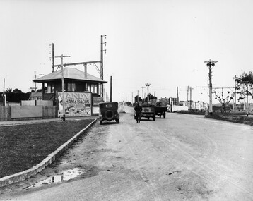 City of Kingston
Photograph - Black and white, c. 1930
... Nepean Highway... and streetscapes in what is now the City of Kingston. The Nepean Highway ...This image is part of a larger collection of images from the Public Transport Corporation displaying train stations and streetscapes in what is now the City of Kingston.The Nepean Highway is a major highway running through the City of Kingston. This image is one of many that depicts its importance to the local community as it undergoes many changes over time.Black and white photograph depicting the level crossing at Moorabbin. While the gates at the level crossing are open, two cars are making their way across the crossing, while a third car is parked on the side of the road, in front of a large billboard/hoarding for ham and bacon products. There is a man standing on the road as if watching the cars go through the crossing. The road appears to be unsealed. Black printed text on a round white sticker adhered to the reverse: 148 Handwritten in red ink: 60% Blue ink stamped on reverse: COPYRIGHT / Public Transport Corporation / For re-ordering photographs / Please quote negative No ADU907 / Enquiries C/- PTC Photographic Unit / Telephone switchboard 619 111moorabbin, trains, railway crossing, level crossing, cars, roads, nepean highway -
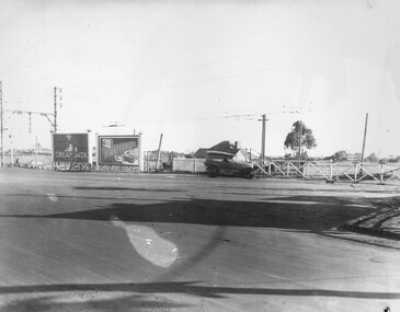 City of Kingston
Photograph - Black and white, c. 1930
... Nepean Highway... and streetscapes in what is now the City of Kingston. The Nepean Highway ...This image is part of a larger collection of images from the Public Transport Corporation displaying train stations and streetscapes in what is now the City of Kingston.The Nepean Highway is a major highway running through the City of Kingston. This image is one of many that depicts its importance to the local community as it undergoes many changes over time.Black and white photograph of the level crossing at Neapean Highway Moorabbin. Photograph is a slightly side view, with a blurred image of a car approaching the level crossing. The gates are closed. To the left of the image is a pair of billboards. The billboard on the left is promoting Creamoata, a New Zealand brand of oats, and the billboard on the right is promoting Kraft cheese.White round sticker on reverse with black printed text: 147 Handwritten in red ink on reverse: 100% Blue ink stamped on reverse: COPYRIGHT / Public Transport Corporation / For re-ordering photographs / Please quote negative No ADV 1030 / Enquiries C/- PTC Photographic Unit / Telephone switchboard 619 111moorabbin, level crossing, railway crossing, cars, advertising, nepean highway -
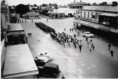 Old School House Museum
Photograph
... Copy of an older photo, Corner of Bay St (Nepean Highway..., Corner of Bay St (Nepean Highway) and Playne St Frankston ...Copy of an older photo, Corner of Bay St (Nepean Highway) and Playne St Frankston. Marching band followed by Possible service men or scouts -
Clunes Museum
Container - BOTTLE
... SIZE, DISPENSED BY W.I. BUSH AND CO. 3 NEPEAN HIGHWAY, MENTONE..., DISPENSED BY W.I. BUSH AND CO. 3 NEPEAN HIGHWAY, MENTONE, VIC ...BROWN SCREWTOP BOTTLE CONTAINING OIL OF CLOVES - ONE POUND SIZE, DISPENSED BY W.I. BUSH AND CO. 3 NEPEAN HIGHWAY, MENTONE, VIC.local history, medicine, dentistry, medical pharmacy -
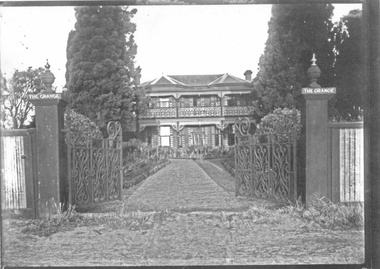 City of Moorabbin Historical Society (Operating the Box Cottage Museum)
Photograph - 3 black & white Photographs, 'The Grange' ( 'Baydon Hill' ) Moorabbin, c 1920
... Tuck, originally named 'Baydon Hill' , at 1011 Nepean Highway... Nepean Highway Moorabbin built by Mr Charles Tuck c1853 known... Nepean Highway Moorabbin built by Mr Charles Tuck c1853 known ...'The Grange ' was a 2 storey home built 1857 by Mr Charles Tuck, originally named 'Baydon Hill' , at 1011 Nepean Highway, Moorabbin ( South Brighton). Mr Charles Tuck was Veterinary Surgeon from Baydon Hill, Wiltshire, England, who migrated to Australia c1850. He married his cousin Miss Jan Chaudler in Melbourne in1853. He was at the Ballarat gold-fields at the time of the riots and then they settled in South Brighton ( later Moorabbin) and built a large Georgian Styled home called 'Baydon Hill'. The Tucks had a large family - 9 children. Charles enjoyed a prosperous Veterinary Practice as his advice was needed for stock purchases by the farmers / settlers. Charles died in 1893 and Jane left the property c 1903 and died at Blackburn in 1928. The House had 5 owners, the last being the Healey family c1920 and at some stage the name was changed to 'The Grange' and the gates shown were installed. The Healey Family were also prosperous in developing vegetables and flower seeds and seedlings. 'The Grange' was sold to Moorabbin City Council 1972 and then used by the City of Moorabbin Historical Society for meetings and storage of historical material. It was demolished amidst considerable controversy 1983 and the District Police Offices were built on the site. ( S.T.Mulvany, Grand-daughter of Charles Tuck 26/7/1974)The Grange was a significant property 1853 -1983 in Moorabbin. It was built by Mr Charles Tuck 1857and in1900 extended from Point Nepean Road to South Road - 10acres. Mr Harold James Healey purchased the property in c1920 and leased a portion to a Chinese market gardener. Later with his sons he established a profitable Plant Nursery that they managed for 42years.. Keith Healey, a son, remodelled the house extensively mid 20thC .The Moorabbin City Council purchased it in 1972 for $255,000 and it was demolished amid controversy 1983. The District Police Offices are now on the site.3x black and white photographs of the property at 1011 Nepean Highway Moorabbin built by Mr Charles Tuck c1853 known as 'The Grange'. Originally it was named 'Baydon Hill' because he migrated from Baydon Hill, Wiltshire, England c1850. These photographs are c 1880, 1920 and 1950 showing the original and later additions made to the property by some of the 5 owners.Written in pencil on back a) " This Photo donated by Mr Neil Follett - at the time it came into his possession he had a photography studio in Cheltenham. Photographer unknown"; Folio 6 b) The Grange c 1950 Folio 6/10 c) 'Baydon Hill' ( alias "The Grange" ) / Donated by Mrs Elsa Jones, daughter of Leslie Stephen Tuck, youngest son of Charles Tuck Folio 6 /18tuck charles, tuck jane, veterinary surgeons, livestock, market gardeners, early settlers, dendy's special survey, brighton, moorabbin, ballarat, gold diggings, horses, chickens, cattle, bullocks, flower shows, fruit garden, mulvaney s. t., healey haold james, healey keith, moorabbin city council, chinese market gardeners, plant nursery, tuck leslie stephen, jones elsa -
 City of Kingston
Photograph - Black and white, 20 December 1945
... ), Nepean Highway and Jamieson Street. Highett Gas Works is visible...), the Methodist Children Homes (now Southland), Nepean Highway ...This aerial photograph depicts the changing landscape of Cheltenham and Highett since WWII. Photographed in 1945, there is a mix of urban dwellings and industrial development and precedes the major transformation of Cheltenham with the development of the Southland shopping centre in the 1960s and expansion in the 1990s.A large part of Cheltenham was originally established as a rural market gardening community. The railway line and station brought urban development to the area and in the north, the Highett area was dominated by the Highett Gas Works. Cheltenham became a major destination for shopping in the 1960s with the opening of Southland.Aerial photograph taken in 1945 of Cheltenham and Highett within the City of Kingston. The image includes the Highett Reserve, (top right), the Methodist Children Homes (now Southland), Nepean Highway and Jamieson Street. Highett Gas Works is visible in the top left and the land now named William Fry Reserve at the intersection of Bay Road and Nepean Highway. A visible large parcel of land on the corner of Bay Road and Nepean Highway was developed in the 1990s as the west side addition to Southland. The densely vegetated area in the upper right sector of the image is now dense with housing. Tulip Grove, Heather Grove and Gilford Street are visible bottom left. This image is possibly from the collection of aerial photographs commissioned by the Department of Crown Lands and Survey and taken by Adastra Airways.Black ink: 57252 White lettering: VIC-10 57252 20.12.45 [lens information indecipherable] PROJ. No.5 MELB. METROP AREA Black pencil: 80highett, cheltenham, highett gas works, urbanisation -
 City of Kingston
Photograph - Black and white, 20 December 1945
... ), Nepean Highway and Jamieson Street. Highett Gas Works is visible...), Nepean Highway and Jamieson Street. Highett Gas Works is visible ...This aerial photograph depicts the changing landscape of Cheltenham and Highett since WWII. Photographed in 1945, there is a mix of urban dwellings and industrial development and precedes the major transformation of Cheltenham with the development of the Southland shopping centre in the 1960s and expansion in the 1990s.A large part of Cheltenham was originally established as a rural market gardening community. The railway line and station brought urban development to the area and in the north, the Highett area was dominated by the Highett Gas Works. Cheltenham became a major destination for shopping in the 1960s with the opening of Southland.Aerial photograph taken in 1945 of Cheltenham and Highett within the City of Kingston. The image includes the Highett Reserve, (top right), the Methodist Children Homes (now Southland), Nepean Highway and Jamieson Street. Highett Gas Works is visible in the top left and the land now named William Fry Reserve at the intersection of Bay Road and Nepean Highway. A visible large parcel of land on the corner of Bay Road and Nepean Highway was developed in the 1990s as the west side addition to Southland. The densely vegetated area in the upper right sector of the image is now dense with housing. Tulip Grove, Heather Grove and Gilford Street are visible bottom left. This image is possibly from the collection of aerial photographs commissioned by the Department of Crown Lands and Survey and taken by Adastra Airways.Black type: Reverse lettering VIC-10 57252 20.12.45 [lens information indecipherable] PROJ. No.5 MELB. METROP AREA White lettering: Reverse writing 57252cheltenham, highett, highett gas works, urbanisation -
City of Kingston
Photograph - Black and white, 17 January 1951
... (top left), Park Road, Cheltenham (top right), Nepean Highway... on the Nepean Highway was a significant feature of the landscape and has ...Moorabbin, Cheltenham and Highett are suburbs in the City of Kingston with a diverse mix of development and zoning. This 1954 image shows the market gardens, farms and paddocks of the Moorabbin and Cheltenham area. which have gradually been sub-divided into The Highett Gas Works is visible and Cheltenham Park and Victoria Golf Club.The suburbs of Cheltenham and Moorabbin were originally developed with extensive market gardens. Over time the district has been transformed with the farms and paddocks replaced by housing, factories and shopping centres. The Highett Gas Works on the Nepean Highway was a significant feature of the landscape and has now been demolished. and the site has undergone remediation.Aerial photograph of Cheltenham, Moorabbin and Highett within the City of Kingston. The area depicted in this 1951 aerial view includes Wickham Road, Highett (bottom right), Keys Road, Moorabbin (bottom left), Centre Dandenong Road Cheltenham (top left), Park Road, Cheltenham (top right), Nepean Highway (left section), Graham Road and Middleton Street, Highett (bottom right). Cheltenham Park and Victoria Golf Club are visible. Nepean Highway and the Frankston railway line run centrally through the image.White type: 1416-37 538 RUN239 LENS 5312" MELBOURNE METROPOLITAN 12150 17-1-51 ↆ M539 Black pencil: N [arrow]cheltenham, highett, highett gas works, market gardens -
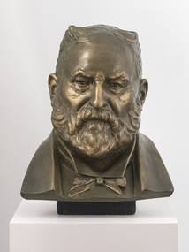 Bayside Gallery - Bayside City Council Art & Heritage Collection
Sculpture, Margaret Baskerville, Sir Thomas Bent, c. 1911
... Baskerville that is located on the corner of Bay Street and Nepean... Baskerville that is located on the corner of Bay Street and Nepean ...This work is a plaster maquette of a large bronze statue of politician and land speculator Sir Thomas Bent by Margaret Baskerville that is located on the corner of Bay Street and Nepean Highway, Brighton.Margaret Baskerville, Sir Thomas Bent c.1911, patinated plaster, 55 x 49 x 49 cm. Bayside City Council Art and Heritage Collection. Donated by Charles Douglas Richardson, 1931.patinated plaster thomas bent, politician, mayor, premier, bust, sculpture, margaret baskerville, land speculator, speaker, local government, councillor, member of lower house, portrait -
Glen Eira Historical Society
Document - BOX FAMILY
... Nepean Road/Highway... St. Kilda Road Nepean Road/Highway McKinnon Ormond Carnegie ...Extensively detailed family history from 1838 in UK to present day. Provides much local history and social history into early pioneering and market gardening families. Forty one page computer print out with numerous black and white photographs.box w.h. george, box george, box mary nee cripps, box caroline, box william, box henry, box john, box anna, box eliza, box elizabeth nee avis, box francis, box lydia, moeller a., mclean n., robilliard george james, box ester, box fanny (downard), box eleanor, philbrick richard, fairlam richard, hale jasper, dendy henry, renick mark, renick stefanie (nee riemann), brighton cemetery, ormond, east brighton, prahran, centre road, jasper road, manchester road, mckinnon road, north road, brighton, box cottage, moorabbin historical society, thomas street, elsternwick, paterson road, east bentleigh, tucker road, jasper road, harwood thomas, box violet, hordeen lebbens, augustus arthur, wattle, pioneers, ancient order of foresters, council of moorabin, elster creek, primitive methodist church, lewis’ timber yard, grape growing, paling house, wells, water wagon, market gardens, farming, aboriginal people, king billy, chinese, kayon (?), kay you (yu?), cheong ki, boxer rebellion, chinese missionary, brickmakers, midwife, corben’s monumental masons, sculptor, cottage, parlour, verandah, scullery, le man’s swamp, flower nursery, chook houses, ladies college, moorabbin roads board, western market, eastern market, victoria market, st. kilda road, nepean road/highway, mckinnon, ormond, carnegie, oakleigh, murrumbeena, moorabbin, mordialloc, heathcote, bentleigh, brighton east, manchester road, brighton council, city of moorabbin, west joseph, porter harriet, moore henry, moeller a (moller), box mary, lindsay mccurry elizabeth, lindsay elizabeth, lindsay henry, lindsay frederick, schmidt william, robilliard james cpt., beckett ida, beckett nellie, beckett martha, beckett martha maud, robinson eleanor, robinson joyce, dowling thomas, anderson william snowden, mccurry henry mr & mrs, box emily jane (nee mccurry), jorgensen justin, jorgensen dr., jorgenson bertha, ross william murray, st. kilda, merrie creek, pentridge (now coburg), murray road, wyuna dunoos st, grange road, rosstown, tucker rd, elizabeth st, common school no 213 east brighton, bentleigh, steel roads tracks, rabbits, cheltenham, brighton cemetery, cheltenham cemetery, paterson road, east boundary road, baptist church, lay preachers, missionaries- china, oakleigh tyre works, belfast hotel sandhurst (bendigo), mornington, gas street lighting, brighton historical society, moorabbin primary school, bravis road, lewis street, chalmers street, grange road, butcher shops, ormond state school, oakleigh council, wedding dress, methodist children’s home cheltenham, bentleigh baptist church, auctioneer, lindsay mark, balkham jane, balkham stephen, reitman august william, fitzwilliam catherine, quashdorf (?phonetic) mr, box violet, montford paul, reitman stephanie (renick mrs), reitman william, box ada, downard alicia (lill), downard arthur, downard edward, graham elizabeth, downard octavia rose, downard william alfred, downard arthur henry (harvey), downard fanny, thompson eliza jane, box lena caroline, viloudaki rebecca, box anna (pay), pay henry, box eliza (gurr), johnson geoffrey, rushall eleanor (nellie), gurr eliza nee box, gurr jabez henry tasman, marriot william mrs, ross william murray, box gladys (nee battersby), box dulcie (bussell), bussell samuel robert, bussell norma (hoult), bussell darren lyle, bussell craig andrew, bussell sylvia june (barry), barry j. haydon, barry rachael alexandra, barry phillipa anne, barry vanessa kate, bussell joan lorraine (millie), millie john, bussell harold leslie, euston mr, purdue edgar robert, box lydia elizabeth, wilkinson coral doreen, mitchell donald, centre road, court pride of st george aof, dunoon street, vickery street, darey street/ave., oakleigh state school, methodist church, mill street, koornang road, regent street, marriage road, box olivia christina, box ernest charles, box walter william, lawson robert, lawson nancy eunice (curtis), box walter stanley, box eleanor (nellie) rushall, box martha, box john, box nellie gladys, andrews william (bill), box ray, mccurry mrs elizabeth, box william henry george, schreiber family, jorgensen family, downward arthur, downward alicia – lill, downward octavia rose, downward william alfred, downward arthur henry/harvey, cummings ida, cummings william, downward alice (nee cleary), downward ada, downward lucy (mrs bailey), downward alice, downward arthur harvey, bailey lawrence, bailey ian, bailey carol viola (bartlett), bailey colin harvey, bailey julie alison (hardware), bailey val, bailey adina, bailey david, bartlett brian, bartlett bradley grant, bartlett clayton lawrence, hardware michael, hardware dion michael colin, hardware jevon michael bailey, box elanor, box alice amelia (dale), dale george, dale elizabeth, dale lilly, dale john, dale thomas, dale rose, dale ethelbert, dale george, dale elsie, box thomas henry, box annie lavinia (rogers), rogers annie elizabeth, rogers william richard, box arthur walter, nelson dagma marie (box), box walter kingston, box marie, box cecilia eliza (ainger), ainger james, box ida may, cumming william george, cumming wendy (nee mansell), cumming susan, cumming paul, cumming felicity (steel), cumming shane, cumming melissa, cumming angel, box harold, box dorothy may (jackson), jackson frederick, jackson margaret (walker), jackson judith, walker david, walker michelle (neville), neville andrew, walker darren, walker rebecca (coyne), walker joshua, walker bradley, johnson steven, johnson carl, johnson judith (jackson), johnson peter, johnson melissa (hamid), johnson craig, ely johnson/jackson judith, ely steven, linham arthur, box thelma elizabeth (eagle), eagle keith, eagle nancye elizabeth (harpin), harkin john, harkin mary anne (howe), howe barry, howe samuel, harkin michael, harkin christopher, harkin elizabeth, eagle roddan, eagle carolyn (mansell), eagle gerard, eagle kerri – lee, box avis ann (eldridge), eldridge alf, eldridge robert, eldridge sandra, eldridge adam, eldridge nicholas, eldridge patric, eldridge john, eldridge carol (biggs), eldridge robert james, eldridge catherine elizabeth, eldridge meredith, box william john, box maud (nee hanchette), box malcome, box sandra (ede), box stephen, box nicolle, box andrew, box christine (dormer), box corrina, box jennifer (turpin), turpin phillip, box herbert, box olwyn (richard), box elaine henry, henry bruce, henry james, henry robin, henry david, box richard, box nerida (bowen), box duncan, box john, box cerwiden, box ewan, box bryan, box collen (malony), box kieran, box eden, box christopher, box pam (smith), box sue (tirchett), box thomas, box william, box george frederick, box olive (cameron), box eliza jane (thompson), box francis george, box lena caroline, box-hembrow mable alma, box charles francis, clinch mr., box robinson jessie melinda, box clay edith florence, north brighton, waun alex, waun robert, marquis peter, sheppard w., warnbach mr, marriott william mrs, box dorothy (seabrook), box hazel, box jessie, box frank (francis), seabrook len, box henry, seabrook albert, seabrook stanley allan, barry j. haydon, barry rachel alexandra, millie john, bussell harold leslie, bussell sue, bussell leanne melinda, bussell benjamin leslie, bussell lynette, box george, box jean (holms), box george, box alisa (hughes), hughes justin, hughes ebony, hughes tasman, box robin, box veronica (roman), box andrea roman, box lisa roman, box jodi roman, box malcome, box sue (kerrison), box amanda, box anthony, clay john (jack) francis, clay lynda blanche (nee sibte), clay vivien, clay majory joy, lipman vernon (vern) ronald, clay kenneth graham, clay laura jean -
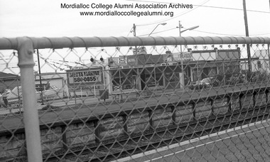 Mordialloc College Alumni Association Inc (MCAA)
Photograph, 1981 - Aspendale Station photographed from Station Street
... Photograph depicts shops on Nepean Highway side... photographed from Station Street Photograph depicts shops on Nepean ...Photograph depicts shops on Nepean Highway side of Aspendale Station - Siesta Marine, the pin-ball parlour, Velo’s hairdresser/barber and The Coq au Vin Restaurant corner Foster Streetaspendale shops -
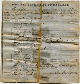 City of Moorabbin Historical Society (Operating the Box Cottage Museum)
Certificate - Certificate of Marriage for Stephen Tuck & Catherine Draper, 1857
... of the district, he had a market garden on Nepean Highway, Cheltenham... garden on Nepean Highway, Cheltenham. The family continued ...Stephen Tuck was one of the original settlers of the district, he had a market garden on Nepean Highway, Cheltenham. The family continued the market garden for over 70 years. It was subdivided and sold as residential blocks in 1940. Original Marriage Certificate of Stephen Tuck and Catherine Draper, in Moorabbin on 19 January 1857.stephen tuck, cheltenham, market gardens, city of moorabbin, land sales, marriage, catherine draper -
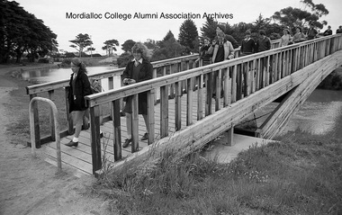 Mordialloc College Alumni Association Inc (MCAA)
Photograph, 1985 - Mordialloc-Chelsea High School students cross the newly completed footbridge
... Creek so that students no longer had to cross over the Nepean... the Nepean Highway bridge. This enabled a safer and quicker journey ...The footbridge finally linked either side of a Mordialloc Creek so that students no longer had to cross over the Nepean Highway bridge. This enabled a safer and quicker journey for many pupils living north of the school.Image digitised from negativemordialloc creek, foot bridge -
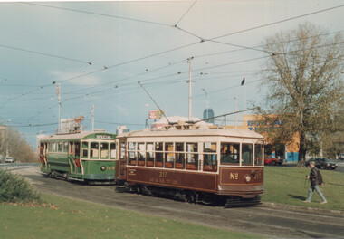 Melbourne Tram Museum
Photograph - TMSV tour trams 217 & 164, Keith Stodden, 13/6/1988
... , Elizabeth St) and the East Brighton (Hawthorn Road and Nepean...) and the East Brighton (Hawthorn Road and Nepean Highway) Yields ...Photographs show trams S164 and X 217 on a TMSV tour 13/6/1988 at Haymarket junction (Royal Parade and Flemington Road, Elizabeth St) and the East Brighton (Hawthorn Road and Nepean Highway) Yields information about TMSV toursSet of two colour prints.tramways, trams, tmsv, tours, haymarket, east brighton, tram 217, tram 164 -
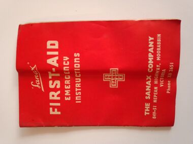 Warrnambool RSL Sub Branch
Equipment - WW2 Field Medical Kit- contents, part of, Sanax FIRST AID EMERGENCY INSTRUCTIONS Booklet
... . THE SANAX COMPANY 849-51 NEPEAN HIGHWAY MOORABIN VICTORIA. Phone... INSTRUCTIONS. THE SANAX COMPANY 849-51 NEPEAN HIGHWAY MOORABIN VICTORIA ...Small booklet, 23 pages. Red Cover of thin cardFront Cover: Sanax FIRST AID EMERGENCY INSTRUCTIONS. THE SANAX COMPANY 849-51 NEPEAN HIGHWAY MOORABIN VICTORIA. Phone XU2651 Inside Pages: first-aid treatment instructions and advertising of Sanax products -
City of Kingston
Photograph - Black and white, 20 December 1945
... Street. A large block of land runs between the Nepean Highway... Street. A large block of land runs between the Nepean Highway ...This aerial image covers a section of Cheltenham, with a large paddock yet to be converted to an industrial and later a commercial zone.This aerial photograph provides evidence of the changing landscape of Cheltenham and Highett since WWII. Photographed in 1945, the image features a large block of land now the site of site the major transformation of Cheltenham with the development of the Southland shopping centre in the 1960s and expansion in the 1990s.Aerial photograph of the Cheltenham area in the City of Kingston. This 1945 image is concentrated on the area between Bay Road and Garfield Lane with the distinctive bend into Jean Street. A large block of land runs between the Nepean Highway and the rail line. This is now the area occupied by the extension of Southland in the 1990s.cheltenham, southland, aerial photograph, highett -
 City of Kingston
Photograph - Black and white, c.1945
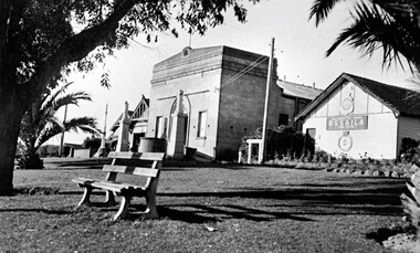
... This photograph shows the Protestant Hall on Nepean Highway...This photograph shows the Protestant Hall on Nepean Highway ...This photograph shows the Protestant Hall on Nepean Highway Cheltenham, which at the time of the photograph was used by the Returned Sailors' Soldiers' and Aimen's Imperial Leage of Australia (RSSAILA). The building facade, World War I memorials, fire station building and road plantation are also in view. The Protestants Hall was built by the Cheltenham Protestant Hall Company Limited in 1886. The hall has been used for a wide variety of purposes; in earlier times it served as the Sunday School for the Methodist Home for Children, and later as a schoolhouse when the Beaumaris School (now Cheltenham State School) No 84 met with overcrowding problems. It was also a popular venue for annual balls and regular dances held by church groups and sporting organisations. The City of Moorabbin purchased the building in the 1920's for use by the Returned Soldiers and Sailors League, in whose hands it remained until the late 1970s when it was taken over by a catering firm. During the 1920s, and right up to the late 1950s, it also served as Cheltenham's picture theatre. The three memorial columns, one from the South African War, one from World War I and one from World War II previously located in front of the hall were relocated when Nepean Highway was widened. The Protestant Hall still stands at 1261 Nepean Highway CheltenhamBlack and white digital image depicting three buildings. The right hand building bears a sign that reads RSSAILA. There are trees and a bench seat in the foreground. There is a World War I memorial pictured. world war i, world war ii, protestant hall, cheltenham, returned sailors' soldiers' and aimen's imperial leage of australia (rssaila), returned and service's league (rsl) -
City of Kingston
Photograph - Black and white, 20 December 1945
... Street. A large block of land runs between the Nepean Highway... of land runs between the Nepean Highway and the rail line ...This aerial image covers a section of Cheltenham, with a large paddock yet to be converted to an industrial and later a commercial zone.This aerial photograph provides evidence of the changing landscape of Cheltenham and Highett since WWII. Photographed in 1945, the image features a large block of land now the site of site the major transformation of Cheltenham with the development of the Southland shopping centre in the 1960s and expansion in the 1990s.Aerial photograph of the Cheltenham area in the City of Kingston. This 1945 image is concentrated on the area between Bay Road and Garfield Lane with the distinctive bend into Jean Street. A large block of land runs between the Nepean Highway and the rail line. This is now the area occupied by the extension of Southland in the 1990s. It is a negative version of VKHC124.cheltenham, southland, market garden -
 City of Moorabbin Historical Society (Operating the Box Cottage Museum)
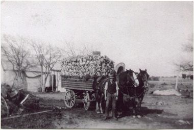
Photograph, Black & White, V Peterson East Boundary Rd East Bentleigh loaded wagon c1900, original c1900
... the Plateways that ran along Centre Road and Nepean Highway. ... and Nepean Highway. The early settlers like the Petersons ...The Peterson family were early settlers in Moorabbin Shire and established a market garden in East Boundary Road East Bentleigh. Vic Peterson and family loaded the crop - cabbages - onto the horse drawn wagon and set off to the Melbourne market using the Plateways that ran along Centre Road and Nepean Highway. The early settlers like the Petersons , in the Parish of Moorabbin County of Bourke after Henry Dendy's Special Survey Brighton 1841, established market gardens, fruit & flower gardens, poultry & dairy farms, vineyards as well as shop businesses, blacksmiths, chemists, nursing homes and schools & Churches.Black & White photograph showing Vic Peterson beside the horse drawn wagon loaded with 35dozen ( 12x 35) cabbages setting off to market c 1900 Original re-digitised by H Stanley 2005Back Hand written informationwagons, vulcan trucks, draught horses,, peterson vic, marriott dick, cabbage crops, vegetable crops, poliomyelitis epidemics 20thc , elster creek, plateways moorabbin shire, smith j l; smith mary ann, stanley helen, smith vic, smith harry redvers, chaff cutter, horse drawn carts, toll gates brighton, motor cars 1900, steam engines, early settlers, bentleigh, mckinnon, parish of moorabbin, city of moorabbin, county of bourke, moorabbin roads board, shire of moorabbin, henry dendy's special survey 1841, were j.b.; bent thomas, o'shannassy john, king richard, charman stephen, highett william, ormond francis, maynard dennis, market gardeners, vineyards, orchards -
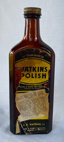 City of Moorabbin Historical Society (Operating the Box Cottage Museum)
Domestic object - Watkins Polish, J. R. Watkins Co (USA), 20thC
... at Highett on a six acres on the east side of Nepean Highway... at Highett on a six acres on the east side of Nepean Highway ...The J. R. Watkins Co. opened its first overseas branch in Australia in 1935. The J. R. Watkins built a large factory at Highett on a six acres on the east side of Nepean Highway (no. 1123) in 1954. The J. R. Watkins company was founded in 1868 in Plainview, Minnesota USA, moving to Winona in 1885, by J. R. Watkins.Example of industry in the City of Moorabbin.Amber glass bottle with a metal screw on lid. A paper label is on the front of the bottle 'Watkins Polish" printed in yellow, black and white.PRINTED ON LABEL: 11 Fluid ounces - WATKINS POLISH - Gives a hard dry lustre excellent for Dusting For cleaning, dusting and polishing furniture, pianos, woodwork, linoleum, hardwood floors and all polished surfaces. Directions: If the article to be polished is dirty or gummy, clean it by washing with mild soap and warm water. Apply Watkins Polish with a damp, soft cloth (Dampened with water and wrung almost dry). The Polish may be poured on the damp cloth or on the surface to be polished. In either case rub it all with a dry cloth to obtain a high polish. When dusting, dampen the cloth with Watkins Polish - it keeps down the dust and gives a lustre which is neither greasy not gummy. The J. R. Watkins Co. Melbourne - Sydney - Adelaide - Kogarah EMBOSED ON BOTTLE: "The J.R.Watkins co. Made in Australia" the j. r. watkins co, highett, polish -
 Bayside Gallery - Bayside City Council Art & Heritage Collection
Sculpture, Margaret Baskerville, Sir Thomas Bent, 1913
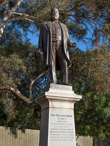
... in her career. Originally located in the centre of the Nepean... career. Originally located in the centre of the Nepean Highway ...Arguably Margaret Baskerville’s most famous work, the bronze statue of politician and land speculator Sir Thomas Bent was Baskerville’s first public commission and a significant turning point in her career. Originally located in the centre of the Nepean Highway, in Brighton, it became somewhat of signpost for many Melbournians until it was relocated to the corner of Bay Street in 1980.The statue of Sir Thomas Bent is of historic and social significance to the State of Victoria. The statue is historically significant for commemorating Bent's long, active and infamous political career in Victoria. He was responsible for many important speculative ventures both within his electorate and in the wider context of Victoria. Although not without thought for personal gain, Bent was a committed advocate of public utilities, railways, roads, tramways and gasworks. The statue is historically significant as the first large public commission given to a woman sculptor in Victoria. This work helped the sculptor, Margaret Baskerville, preserve her name as Victoria's first professional woman sculptor. The statue is socially significant as testimony to the late nineteenth century land boom and the financial and political corruption and scandals that accompanied it. https://vhd.heritagecouncil.vic.gov.au/places/12614bronze and granite thomas bent, politician, mayor, premier, bust, sculpture, margaret baskerville, speaker, member of parliament, member of lower house, local government, councillor, brighton, public art, bayside -
 City of Moorabbin Historical Society (Operating the Box Cottage Museum)
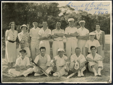
Photograph, Black & White, St Matthew's Church of England Cricket Team c 1940, c1940
... of England was erected in Cheltenham beside the Nepean Highway near... was erected in Cheltenham beside the Nepean Highway near Charman Road ...The Cheltenham parish was created in 1865 by excising a portion of the parish of St Andrews Brighton. A small brick church was completed in 1867 to serve a rural community stretching from Brighton South (Moorabbin) to Mordialloc. 1867 St Matthew's Church of England was erected in Cheltenham beside the Nepean Highway near Charman Road. The early settlers established a tennis club, cricket team and social groups.St Matthew's Church of England Cheltenham was erected in 1867 and was integral to the spiritual well being and social life of the early settlers.Black & White photograph of the St Matthews Church of England Cricket team Cheltenham c 1940Front ; Church of England Cricket Team 1940 Back ; Written - Ladies / Hilda Biehl, Bertha Schneeberber, Mrs Wootton, / We made afternoon tea from / a kerosene tin for 30 players / each Saturday they played at home !!smith j l; smith mary ann, stanley helen, chaff cutter, horse drawn carts, toll gates brighton, motor cars 1900, steam engines, early settlers, bentleigh, parish of moorabbin, city of moorabbin, county of bourke, moorabbin roads board, shire of moorabbin, henry dendy's special survey 1841, were j.b.; bent thomas, o'shannassy john, king richard, charman s, highett william, ormond francis, maynard dennis, market gardeners, vineyards, orchards, -
 City of Kingston
Photograph - Black and white, c. 1970
... The Highett Gas Works were a landmark along the Nepean...The Highett Gas Works were a landmark along the Nepean ...The Highett Gas Works were a landmark along the Nepean Highway for many years. With the cessation of the gasification of coal and the introduction of natural gas to Victoria, the gas holders were demolished and the Sir William Fry Reserve was developed on the southern end of the site. The Gas and Fuel redeveloped the northern end of the site with modern offices and laboratories for the organisation's scientific services. At this time, the chimney and retort house were retained.The Highett Gasworks had its beginning in 1939 operated by the Central Brighton and Moorabbin Gas Co Ltd. The company had expanded its gas production facilities to Highett where it had purchased 45 acres of land adjacent to the Melbourne-Frankston railway line. The first gasholder was erected on the Highett site in 1927 and connected with high pressure mains to the Brighton Gas Works. In 1939 the building program including gasometers, the vertical retort house and coal store was completed and gas making commenced. Its area of supply covered approximately 70 square miles and included the municipalities of Brighton, Sandringham, Moorabbin, Mordialloc, Chelsea and part of Dandenong. The Gas and Fuel Corporation eventually took over operations and with the disaggregation and privatisation of the organisation, the site was eventually closed c. 2002.Black and white aerial photograph featuring the Highett Gas Works with gasholders and retort house. In the top right-hand corner, a former Highett Primary School on Graham Road can be viewed. Photograph includes Bay Road, Royal Avenue, Princess Avenue and Jackson Road (Highett) and Alfred, Turner and Sandford Streets (Moorabbin).Handwritten in black ink: [indecipherable] in a circle Handwritten in red ink: 70% Four velcro display adhesivesgasification of coal, gas and fuel corporation of victoria, gasholders, highett, moorabbin, utilities -
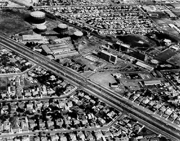
City of Kingston
Photograph - Black and white, 5 January 1984
... and Nepean Highway (bottom left), Balmoral Drive/McSwain Street... and Nepean Highway has now been replaced by high rise apartments ...Cheltenham and Heatherton are suburbs in the City of Kingston that were originally established as a rural market gardening community. The market gardens, farms and paddocks have gradually been sub-divided into housing and industrial estates and associated infrastructure such as schools and shopping facilities. This aerial image covers a diverse section of the City of Kingston, taking in the suburbs of Cheltenham, Heatherton, Mentone and Parkdale. By 1984, the market gardens of the district have been replaced by housing and factories. The Nylex factory is visible and now closed. Mentone Bowl on the corner of Warrigal Road and Nepean Highway has now been replaced by high rise apartments, another feature of the changing landscape in the City of Kingston. The vacant land now occupied by the Moorabbin Airport Direct factory Outlet (DFO) is also depicted.Aerial photograph of Cheltenham, Heatherton, Mentone and Parkdale within the City of Kingston. The area depicted in the 1984 aerial view includes Centre Dandenong Road and Cheltenham East Primary School (top left), Kingston Heath Reserve (top right), intersection of Lower Dandenong Road, Warrigal Road, Balcombe Road and Nepean Highway (bottom left), Balmoral Drive/McSwain Street Parkdale (bottom right).White text: 3831-179 Lens information [indecipherable] RINGWOOD M/S 7922-3 RUN 16 [Clockface image] 5,300' ASL VIC DLS© 5-1-84cheltenham, heatherton, mentone, parkdale, market gardens, urbanisation