Showing 170 items matching "nepean highway"
-
 Glen Eira Historical Society
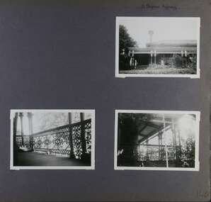
Album - Album page, 31 Nepean Highway, Circa 1972
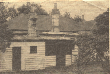
... 31 Nepean Highway......nepean highway...Page 140 of Photograph Album with three (landscape) photographs of Roseneath on Nepean Highway. ...Handwritten: 31 Nepean Highway [top right] / 140 [bottom right]...31 Nepean Highway, Elsternwick, Melbourne, Victoria, Australia..."Roseneath" compares with "Cumbernauld" (pre 1872) at 504 Hawthorn Road and "Glenmoore" (1870) at 1 St Georges Road. trevor hart verandah chimneys porch decorative brackets single storey cast iron columns return verandah garden nepean highway roseneath italianate 1870's elsternwick cast iron work victorian style polychrome bricks william millar slate roofs brick houses house names Handwritten: 31 Nepean Highway [top right] / 140 [bottom right] Page 140 of Photograph Album with three (landscape) photographs of Roseneath on Nepean Highway. 31 Nepean Highway Album Album page ...This photograph is part of the Caulfield Historical Album 1972. This album was created in approximately 1972 as part of a project by the Caulfield Historical Society to assist in identifying buildings worthy of preservation. The album is related to a Survey the Caulfield Historical Society developed in collaboration with the National Trust of Australia (Victoria) and Caulfield City Council to identify historic buildings within the City of Caulfield that warranted the protection of a National Trust Classification. Principal photographer thought to be Trevor Hart, member of Caulfield Historical Society. Most photographs were taken between 1966-1972 with a small number of photographs being older and from unknown sources. All photographs are black and white except where stated, with 386 photographs over 198 pages. Victorian Heritage Database - HO48 - 31 Nepean Highway Elsternwick https://vhd.heritagecouncil.vic.gov.au/places/35531 (at 15/08/2021) "Roseneath" at 31 Point Nepean Road is a bi-chromatic Italianate villa built for William Millar in 1874. It is aesthetically and historically important. "Roseneath's aesthetic value derives from its survival as a substantially intact bi-chromatic brick villa, distinguished by the symmetrical north and south facing bays and by its spacious grounds. Its historical value rests on its comparatively early date and link with Shire councillor William Millar. The choice of bi-chromatic brick, which was highly fashionable at the time, is also of note. "Roseneath" compares with "Cumbernauld" (pre 1872) at 504 Hawthorn Road and "Glenmoore" (1870) at 1 St Georges Road.Page 140 of Photograph Album with three (landscape) photographs of Roseneath on Nepean Highway. Handwritten: 31 Nepean Highway [top right] / 140 [bottom right]trevor hart, verandah, chimneys, porch, decorative brackets, single storey, cast iron columns, return verandah, garden, nepean highway, roseneath, italianate, 1870's, elsternwick, cast iron work, victorian style, polychrome bricks, william millar, slate roofs, brick houses, house names -
 Glen Eira Historical Society
Document - Roseneath, Nepean Highway, 31, Elsternwick
... Roseneath, Nepean Highway, 31, Elsternwick...... Nepean Highway...31 Nepean Highway, Elsternwick, Victoria, Australia...Ward Andrew Millar William Boyle Andrew Worthington George Tulloch Annie Cross Anastasia Meek Alex Caulfield Roseneath Elsternwick Nepean Highway McMillan Street Point Nepean Road Rusden Street Cumbernauld Hawthorn Road Glenmoore St. ...A photocopy of a Caulfield Conservation Study conducted in January 1995 by historian Andrew Ward of the house Roseneath named thus by 1904. The document includes a photocopied photograph of the front façade, although the features are unclear. The document, which includes a bibliography, details the history of Roseneath, including owners and occupiers, as well as the architectural features of significance and historical value.ward andrew, millar william, boyle andrew, worthington george, tulloch annie, cross anastasia, meek alex, caulfield, roseneath, elsternwick, nepean highway, mcmillan street, point nepean road, rusden street, cumbernauld, hawthorn road, glenmoore, st. georges road, caulfield south, shire of caulfield, east st. kilda riding, historic buildings register, national trust register, national estate register, italianate style, architectural styles, architectural features, mansions, brick houses, verandahs, cast iron work, bluestone, bay windows, land subdivisions, merchants, judges, leases, councillors -
 City of Kingston
Photograph - Digital image, Black and white, Roads - Junction of Nepean Highway and South Road, c. 1950
... Roads - Junction of Nepean Highway and South Road...Nepean Highway...Junction of Nepean Highway and South Road, Moorabbin - Moorabbin Hotel on right. ...Black and white image of Nepean Highway and South Road junction point of view from Kingston Town Hall...City of Kingston Parkdale Library 96 Parkers Road, Parkdale Parkdale Junction of Nepean Highway and South Road, Moorabbin - Moorabbin Hotel on right. ...Junction of Nepean Highway and South Road, Moorabbin - Moorabbin Hotel on right. Shops in centre demolished for road widening in 1980'sBlack and white image of Nepean Highway and South Road junction point of view from Kingston Town HallPrinted in black text a round white sticker: 234 Handwritten in red ink 80% Yellow post it note written in blue ink: CHAP 7 234 / - Nepean Hwy + South Roadnepean highway, south road, moorabbin, moorabbin hotel -
 Chelsea & District Historical Society Inc
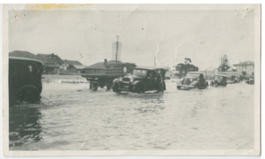
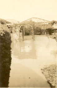
Photograph - Chelsea Flood December 1934, Point Nepean Road (Nepean Highway)
... Point Nepean Road (Nepean Highway)......Nepean Highway...Black and white photo of flood waters across Point Nepean Road (now Nepean Highway). Cars and trucks are driving through the water....Chelsea & District Historical Society Inc The Chelsea Activity Hub 3-5 Showers Ave Chelsea 3196 melbourne In December 1934, 700 houses were inundated with water, when the Dandenong Creek and Patterson River broke their banks. flood chelsea Dandenong Creek Nepean Highway Point Nepean Road Black and white photo of flood waters across Point Nepean Road (now Nepean Highway). ...In December 1934, 700 houses were inundated with water, when the Dandenong Creek and Patterson River broke their banks.Black and white photo of flood waters across Point Nepean Road (now Nepean Highway). Cars and trucks are driving through the water.flood, chelsea, dandenong creek, nepean highway, point nepean road -
Glen Eira Historical Society
Ephemera - ROSENEATH, NEPEAN HIGHWAY, 31, ELSTERNWICK
... ROSENEATH, NEPEAN HIGHWAY, 31, ELSTERNWICK...31 Nepean Highway, Elsternwick, Victoria, Australia...Captain Lloyd Mary Lloyd Nova Lloyd Eileen Meek Anastasia Mary Meek William John Meek Monica Venus Engineers Marine surveyors Social events and activities Wills and estates Real estate Advertisements Ephemera ROSENEATH, NEPEAN HIGHWAY, 31, ELSTERNWICK ...This file contains 8 pages and one property notice. The file contains: 1/descriptions from Andrew Ward’s Heritage Planning Report. Notes on residents of ‘Roseneath’ from 1866 to 1963. Articles include household goods sale, public notices, wills and estate notices from Trove and census record. Details from Ancestry.com 2016. 2/Property sale notice of ‘Roseneath’ dated 04/03/2016 from Leader newspaper.‘roseneath’, house names, point nepean road, elsternwick, bogle andrew esq., auctions, wragge william, wragge mary, wragge william charles, miller william, councillors, rusden street, mcmillan street, subdivision, boyle andrew, merchants, shire of caulfield, east st kilda riding, breckinhill lodge, bogle andrew mrs., wragge w mrs, st kilda cemetery, cemeteries, kirkham councillor, long councillor, riddell councillor, lempriere councillor, ilberry concillor, worthington george, judges, tulloch annie, st kilda ladies benevolent society, worthington mrs, wheeldon isaac, tulloch w.g., breweries, elsternwick, madame berry west company, tulloch and son, mccracken’s brewery, elsternwick station, ‘elderslie’, glenhuntly road, wheeldon sarah, cross anastacia, brick houses, meek alexander charles, meek una eveline, meek david, meek jane, meek james, meek alexander, meek kathleen, meek william, lloyd i. captain, lloyd mary, lloyd nova, lloyd eileen, meek anastasia mary, meek william john, meek monica venus, engineers, marine surveyors, social events and activities, wills and estates, real estate, advertisements -
 Melbourne Tram Museum
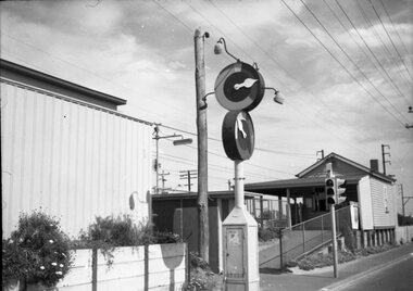
Negative - Marshalite traffic light Nepean Highway, Hugh Ballment, c1954
... Marshalite traffic light Nepean Highway ......Nepean Highway...station. traffic lights Marshalite railways Nepean Highway Negative - 127 film black and white Negative Marshalite traffic light Nepean Highway Hugh Ballment ...The photograph shows a Marshalite traffic signal at a railway station along the Frankston line - such signals were provided at Chelsea, Bonbeach and Aspendale.Yields information about the Marshalite traffic lights installed at ? station.Negative - 127 film black and whitetraffic lights, marshalite, railways, nepean highway -
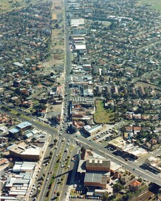 City of Kingston
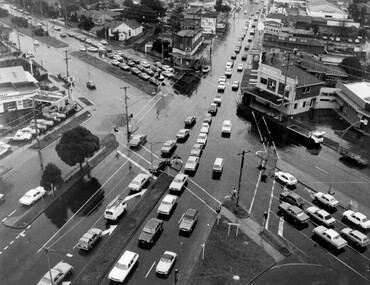
Photograph - Colour, c. 1982
... Nepean Highway...This aerial photograph of South Road and Nepean Highway, Moorabbin shows the area where houses and shops on the south side of the Nepean Highway have demolished for the widening of the highway. ...Colour photograph of an aerial view of South Road and Nepean Highway, Moorabbin. The image shows houses on the south side of the Nepean Highway that have demolished for widening of road. ...City of Kingston Parkdale Library 96 Parkers Road, Parkdale Parkdale This aerial photograph of South Road and Nepean Highway, Moorabbin shows the area where houses and shops on the south side of the Nepean Highway have demolished for the widening of the highway. ...This aerial photograph of South Road and Nepean Highway, Moorabbin shows the area where houses and shops on the south side of the Nepean Highway have demolished for the widening of the highway. The pressures of rapid urban development in Moorabbin and beyond, especially to the south of Moorabbin caused bottlenecks and delays, especially at the South Road and Nepean Highway intersection, hence the scheme to widen Nepean Highway.The pressures of rapid urban development in terms of people, housing construction, industrial development and commercial activity, in Moorabbin and beyond, especially to the south would put pressure on road infrastructure in the region. In the early 1980s, a major road expansion of the Nepean Highway was implemented to increase capacity on this major thoroughfare for vehicle commuters. Car use had also increased with commuters from the increasingly populous southern suburbs travelling to their place of work in the Melbourne CBD.Colour photograph of an aerial view of South Road and Nepean Highway, Moorabbin. The image shows houses on the south side of the Nepean Highway that have demolished for widening of road. It features housing and commercial buildings looking north towards Cummins Road.Handwritten blue ink: 82 - 5452 - 11 Handwritten red ink: 112% Handwritten black ink: Ch. 7nepean highway, south road, moorabbin, roads, transport, infrastructure -
 Chelsea & District Historical Society Inc
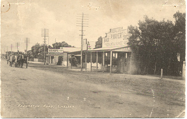
Photograph - Main Road (now Nepean Highway) Chelsea, c 1915
... Main Road (now Nepean Highway) Chelsea...Black and white postcard of the main road, Chelsea (now Nepean Highway) showing P. Mayer's Store and Bishop's Store. ...Photograph Main Road (now Nepean Highway) Chelsea ...Black and white postcard of the main road, Chelsea (now Nepean Highway) showing P. Mayer's Store and Bishop's Store. Bishop's store is on the corner of Wimbourne Avenue, Chelsea. The road is unmade and two wagons are traveling down the road.Frankston Road, Chelseachelsea, mr p. mayer, mr bishop, wagons -
 Melbourne Tram Museum
Letter, Australian Electric Traction Association (AETA), "Proposal to build a tramline down Nepean Highway to Southland", May. 1977
... "Proposal to build a tramline down Nepean Highway to Southland"...The Nepean Highway was being widened at the time. Produced by the AETA. ...The Nepean Highway was being widened at the time. Produced by the AETA. ...Letter with supplementary document - "Proposal to build a tramline down Nepean Highway to Southland", advocating residents support a study into a possible tram line to Southland, May 1977. The Nepean Highway was being widened at the time. Produced by the AETA. Printed by duplicating process on white foolscap paper.trams, tramways, public transport, mmtb, proposals, moorabbin -
 City of Kingston
Photograph - Black and white, Nepean Highway, Cheltenham, c. 1925
... Nepean Highway, Cheltenham...Black and white image of the Cheltenham Post Office, Mechanics Institute Hall and Billiard Room looking across the Nepean Highway....City of Kingston Parkdale Library 96 Parkers Road, Parkdale Parkdale Black and white image of the Cheltenham Post Office, Mechanics Institute Hall and Billiard Room looking across the Nepean Highway. Nepean Highway, Cheltenham Photograph Black and white ...Black and white image of the Cheltenham Post Office, Mechanics Institute Hall and Billiard Room looking across the Nepean Highway. -
 Chelsea & District Historical Society Inc
Photograph - Chelsea Flood December 1934, Carrum Hotel, Nepean Highway
... Carrum Hotel, Nepean Highway......Nepean Highway...Carrum Hotel, Nepean Highway Photograph Chelsea Flood December 1934 ...In December 1934, 700 houses were inundated with water, when the Dandenong Creek and Patterson River broke their banks.Black and white photo of flood waters in the garden of Carrum Hotel, showing an archway and in the background is a partially built building.flood, chelsea, dandenong creek, nepean highway, point nepean road, carrum hotel -
 City of Kingston
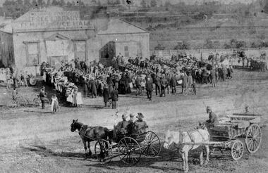
Photograph - Digital image, Black and white, Assembly at Mechanics Hall Temperance Hall and Free Library Cheltenham, c.1900
... ...Nepean Highway...Gathering of people outside the Mechanics Hall, Temperance Hall and Free Library, Nepean Highway, Cheltenham - in background the railway line and paddocks...Black and white image of people gathering outside the Mechanics Hall, Temperance Hall and Free Library, Nepean Highway, Cheltenham - in background the railway line and paddocks...City of Kingston Parkdale Library 96 Parkers Road, Parkdale Parkdale Gathering of people outside the Mechanics Hall, Temperance Hall and Free Library, Nepean Highway, Cheltenham - in background the railway line and paddocks Temperance Hall Nepean Highway Cheltenham Library Mechanics Hall Round red sticker: X16 [crossed out] Handwritten in blue ink circled: A5 Handwritten in red ink: 89% Black and white image of people gathering outside the Mechanics Hall, Temperance Hall and Free Library, Nepean Highway, Cheltenham - in background the railway line and paddocks Assembly at Mechanics Hall Temperance Hall and Free Library Cheltenham Photograph Digital image, Black and white ...Gathering of people outside the Mechanics Hall, Temperance Hall and Free Library, Nepean Highway, Cheltenham - in background the railway line and paddocksBlack and white image of people gathering outside the Mechanics Hall, Temperance Hall and Free Library, Nepean Highway, Cheltenham - in background the railway line and paddocksRound red sticker: X16 [crossed out] Handwritten in blue ink circled: A5 Handwritten in red ink: 89%temperance hall, nepean highway, cheltenham, library, mechanics hall -
 City of Kingston
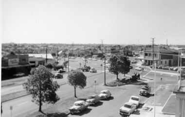
Photograph - Black and white, c. 1950
... ...Nepean Highway...The image shows a line of traffic travelling along South Road in response to traffic light signlas while an increasing number of cars are banking up along Nepean Highway, also in response to traffic light signals....Black and white photograph with an aerial view of the intersection of Nepean Highway and South Road, taken from above the Moorabbin Council Chambers....Moorabbin Traffic lights Cars Nepean Highway Handwritten in black ink Pic [indecipherable] / 1000 Handwritten in red ink: 150% Black and white photograph with an aerial view of the intersection of Nepean Highway and South Road, taken from above the Moorabbin Council Chambers. ...The image shows a line of traffic travelling along South Road in response to traffic light signlas while an increasing number of cars are banking up along Nepean Highway, also in response to traffic light signals.This image provides a strong contrast to images from earlier eras of the same intersection. The amount of traffic has increased enormously as well as commercial development.Black and white photograph with an aerial view of the intersection of Nepean Highway and South Road, taken from above the Moorabbin Council Chambers.Handwritten in black ink Pic [indecipherable] / 1000 Handwritten in red ink: 150%moorabbin, traffic lights, cars, nepean highway -
 Chelsea & District Historical Society Inc
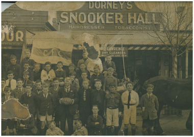
Photograph - Chelsea Football Club, Junior team in front of Dorney's Store, 1922
... ...Nepean Highway...Mr Dorney's Hairdressing and Billiard Saloon was situated at 415 Nepean Highway, Chelsea. The premises was destroyed by fire in August 1937....The group are posed in front of William (Bill) Dorney's Hairdressing shop & Billiard saloon in Nepean Highway, Chelsea...Mr Dorney's Hairdressing and Billiard Saloon was situated at 415 Nepean Highway, Chelsea. The premises was destroyed by fire in August 1937. football Chelsea Junior Football Club Chelsea Sport William Dorney Shop Nepean Highway Horse and cart Black and white photo of junior football players of Chelsea Junior Football Club. ...The Chelsea Junior Football Club with Bill Dorney in front of Bill Dorney Shop. Mr Dorney had taken the boys for a ride on his horse and cart. Mr Dorney's Hairdressing and Billiard Saloon was situated at 415 Nepean Highway, Chelsea. The premises was destroyed by fire in August 1937.Black and white photo of junior football players of Chelsea Junior Football Club. The group are posed in front of William (Bill) Dorney's Hairdressing shop & Billiard saloon in Nepean Highway, Chelseafootball, chelsea junior football club, chelsea, sport, william dorney, shop, nepean highway, horse and cart -
Glen Eira Historical Society
Document - Glenfern
... ... Nepean Highway...Nepean Highway, Elsternwick, Victoria, Australia...Watson Thomas Lauder Watson James Brookman Agnes Montgomery Watson Jessie Watson Thomas Watson Thomas Greenless Watson Kathleen Hall Kathleen Glendora House names Nepean Highway Elsternwick Offices of parliament Document Glenfern ...This file contains four items about the Watson family, sometime owners of Glenfern: 1/ Photocopy of Thomas Lauder Watson family tree, great grandfather of the Watsons of Glenfern, period 1820 to 1988. 2/ Photocopy of James Watson and Agnes Montgomery Bookman Marriage Register entry dated 20/06/1883. 3/ Photocopy of a record for Thomas Watson held on the ScotlandsPeople website noting that his spouse was born 17/10/1816. 4/ Print of article from brightoncemetery.com website on Thomas Greenless Watson, 1859-1912, parliamentary official. Article on his schooling, and his further business history, his marriage details and tribute from Premier William Watt, 1871-1946.watson thomas lauder, watson james, brookman agnes montgomery, watson jessie, watson thomas, watson thomas greenless, watson kathleen, hall kathleen, glendora, house names, nepean highway, elsternwick, offices of parliament -
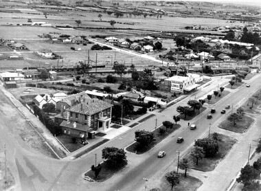
 Bayside Gallery - Bayside City Council Art & Heritage Collection
Photograph, Department of Crown Lands and Survey, Victoria, Brighton, Brighton East and Bentleigh, c. 1965-71
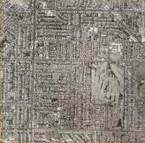
... ...nepean highway...The significant landmark featured is Dendy Park, on the corner of Dendy Street and Nepean Highway. The main roads shown include Centre Road at the top, Nepean Highway diagonally across the photograph and South Road at the bottom....The significant landmark featured is Dendy Park, on the corner of Dendy Street and Nepean Highway. The main roads shown include Centre Road at the top, Nepean Highway diagonally across the photograph and South Road at the bottom. ...The Department of Crown Lands and Survey (1857-1983) was responsible for the administration of survey and mapping and the sale, occupation and management of crown land throughout its existence. This aerial photograph shows parts of Brighton, Brighton East and Bentleigh and was taken circa 1965-71.brighton, department of crown lands and survey, aerial photograph, bayside, port phillip bay, map, cartographic material, bentleigh, brighton east, dendy park, dendy street, centre road, nepean highway, south road, football -
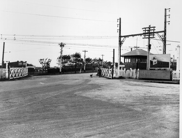
 City of Kingston
Photograph - Black and white
... This photograph depicts the road diversion on Nepean Highway that was implemented to allow construction of the railway line underneath the Nepean Highway at Moorabbin. ...Black and white photograph of road diversion on Nepean Highway, Moorabbin to allow the construction of the railway line below the Nepean Highway at Moorabbin and also to trench the station. ...City of Kingston Parkdale Library 96 Parkers Road, Parkdale Parkdale This photograph depicts the road diversion on Nepean Highway that was implemented to allow construction of the railway line underneath the Nepean Highway at Moorabbin. ...This photograph depicts the road diversion on Nepean Highway that was implemented to allow construction of the railway line underneath the Nepean Highway at Moorabbin. An "Allourie" Cheese, Honey Canned Ham van is prominent on the left of the image, the railway gates are central and the old Moorabbin Station is visble. Beyond the dates, pedestrians are visible crossing the Nepean Highway. This image is part of a larger collection of images from the Public Transport Corporation displaying train stations and streetscapes in what is now the City of Kingston.In 1958 excavations began for the removal of the level crossing gates at the southern end of the Moorabbin shopping centre on Nepean Highway. The station was also lowered below ground. A diversion route was created to enable the flow of traffic in both directions along the highway.Black and white photograph of road diversion on Nepean Highway, Moorabbin to allow the construction of the railway line below the Nepean Highway at Moorabbin and also to trench the station. This image is part of a larger collection of images from the Public Transport Corporation displaying train stations and streetscapes in what is now the City of Kingston.White adhesive dot sticker: Printed black 199 Handwritten in red ink: 80% Handwritten in black ink on yellow Post-It Note: [indecipherable] 199 - Diversion for Crossing Stamped in blue ink: COPYRIGHT Public Transport Corporation, For reordering photographs, Please quote negative No m 5687, Enquiries C/- PTC Photographic Unit, Telephone switchboard 619 1111railway crossing, railway station, city of moorabbin -
City of Moorabbin Historical Society (Operating the Box Cottage Museum)
Pamphlet - St Finbar's Parish Church, East Brighton - Celebrating 150 Years 1848-1998, 1998
... ...Nepean Highway...St Finbar's Roman Catholic Church corner of Nepean Highway and Centre Road, East Brighton....City of Moorabbin Historical Society (Operating the Box Cottage Museum) Joyce Park Jasper Road Ormond melbourne St Finbar's Roman Catholic Church corner of Nepean Highway and Centre Road, East Brighton. St Finbar's Roman Catholic Church East Brighton was erected in 1871 and was integral to the spiritual well being and social life of the early settlers. early settlers parish of moorabbin city of moorabbin county of bourke shire of moorabbin were j.b. market gardeners Nepean Highway East Brighton St Finbar's Parish Centre Road Religion Roman Catholic Four page AO5 brochure inviting people to join in historic 150 year celebration. ...St Finbar's Roman Catholic Church corner of Nepean Highway and Centre Road, East Brighton.St Finbar's Roman Catholic Church East Brighton was erected in 1871 and was integral to the spiritual well being and social life of the early settlers.Four page AO5 brochure inviting people to join in historic 150 year celebration. Contains brief history of the Parish of St Finger's East Brighton.early settlers, parish of moorabbin, city of moorabbin, county of bourke, shire of moorabbin, were j.b., market gardeners, nepean highway, east brighton, st finbar's parish, centre road, religion, roman catholic -
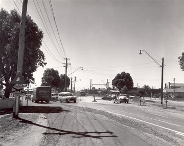
 City of Kingston
Photograph - Black and white, c. 1950
... The intersection of Warrigal Road and Nepean Highway is now a major intersection, serviced by traffic lights. ...Black and white photograph of the intersection of Warrigal Road and Nepean Highway, Mentone. ...City of Kingston Parkdale Library 96 Parkers Road, Parkdale Parkdale The intersection of Warrigal Road and Nepean Highway is now a major intersection, serviced by traffic lights. ...The intersection of Warrigal Road and Nepean Highway is now a major intersection, serviced by traffic lights. In the 1950s it was a joining of two sealed roads, although covered in gravel, and with wide gravel shoulders. There are no traffic signs and the few houses visible are not set very far back from the road. This image is one of many in the collections that focuses on either roads or the railway. The development of roads and the railway was crucial to the ongoing development of the area.Black and white photograph of the intersection of Warrigal Road and Nepean Highway, Mentone. Handwritten in blue ink on reverse: 218 Handwritten in red ink on reverse: 75%mentone, roads, suburbs -
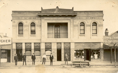 Chelsea & District Historical Society Inc
Photograph - Chelsea Shops, Butcher shop - Chelsea Wine Bar - Upholsterer, 1920's
... ...Nepean Highway...The Chelsea Wine Cafe was situated in Point Nepean Highway opposite the Chelsea railway station. ...Chelsea & District Historical Society Inc The Chelsea Activity Hub 3-5 Showers Ave Chelsea 3196 melbourne The Chelsea Wine Cafe was situated in Point Nepean Highway opposite the Chelsea railway station. ...The Chelsea Wine Cafe was situated in Point Nepean Highway opposite the Chelsea railway station. It offered meals, accommodation and wine. In late 1936 the building was pulled down.Two black and white photos of Chelsea Wine Cafe also in the photos are a butcher shop and an upholsterer.Chelsea Wine Cafe Cash Butcher Upholsterer - All classes of Furniture chelsea, chelsea wine cafe, point nepean road, nepean highway -
 City of Kingston
Photograph - Black and white, c. 1930
... ...Nepean Highway...Black and white photograph depicting railway crossing at Nepean Highway Moorabbin. The level crossing gates are open and a man is walking through with his dog. ...Moorabbin Trains Railway crossing Level crossing Nepean Highway White round sticker with indecipherable black printed text which has been scribbled over with black pen. ...This image is part of a larger collection of images from the Public Transport Corporation displaying train stations and streetscapes in what is now the City of Kingston.The Nepean Highway is a major highway running through the City of Kingston. This image is one of many that depicts its importance to the local community as it undergoes many changes over time.Black and white photograph depicting railway crossing at Nepean Highway Moorabbin. The level crossing gates are open and a man is walking through with his dog. To the right of the crossing is a billboard/hoarding promoting what appears to be a brand of radio/wireless.White round sticker with indecipherable black printed text which has been scribbled over with black pen. White round sticker with black printed text: 175 Handwritten in red ink: 50% Blue ink stamped on reverse: COPYRIGHT / Public Transport Corporation / For re-ordering photographs / Please quote negative No ADV 903 / Enquiries C/- PTC Photographic Unit / Telephone switchboard 619 111moorabbin, trains, railway crossing, level crossing, nepean highway -
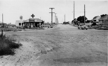
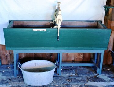 City of Moorabbin Historical Society (Operating the Box Cottage Museum)
Functional object - Laundry Equipment, wooden double wash trough, c1900
... ...nepean highway...c1900 This large wooden double wash trough with 'Acme' clothes wringer came from the old 'Exchange Hotel' now known as The Tudor Inn, Nepean Highway, Cheltenham....City of Moorabbin Historical Society (Operating the Box Cottage Museum) Joyce Park Jasper Road Ormond melbourne c1900 This large wooden double wash trough with 'Acme' clothes wringer came from the old 'Exchange Hotel' now known as The Tudor Inn, Nepean Highway, Cheltenham. The Exchange Hotel, Point Nepean Road, Cheltenham, (now The Tudor Inn Hotel Nepean Highway,) was built in the late 1800s. ...c1900 This large wooden double wash trough with 'Acme' clothes wringer came from the old 'Exchange Hotel' now known as The Tudor Inn, Nepean Highway, Cheltenham.The Exchange Hotel, Point Nepean Road, Cheltenham, (now The Tudor Inn Hotel Nepean Highway,) was built in the late 1800s. By 1915 it was a prominent meeting place for early settler families of Moorabbin Shire. The trough is typical of those used in large laundries c1900 The ACME wringers were used in most households until c1960 Wooden, double washing trough, on a wooden stand c1900moorabbin, cheltenham, brighton, nepean highway, exchange hotel, the tudor inn hotel, clothing, early settlers, pioneers, market gardeners, acme manufacturing company, glasgow. -
City of Moorabbin Historical Society (Operating the Box Cottage Museum)
Booklet - Eightieth Celebration of the Patronal Festival - St Matthew's Church Cheltenham - commemoration of the Dedication 1867-1947, 1947
... ...Nepean Highway...St Matthew's Church of England was erected in Cheltenham beside the Nepean Highway near Charman Road. The early settlers established a tennis club, cricket team and social groups....City of Moorabbin Historical Society (Operating the Box Cottage Museum) Joyce Park Jasper Road Ormond melbourne St Matthew's Church of England was erected in Cheltenham beside the Nepean Highway near Charman Road. The early settlers established a tennis club, cricket team and social groups. ...St Matthew's Church of England was erected in Cheltenham beside the Nepean Highway near Charman Road. The early settlers established a tennis club, cricket team and social groups.St Matthew's Church of England Cheltenham was erected in 1867 and was integral to the spiritual well being and social life of the early settlers.Booklet on the history of St Matthew's Church, Cheltenhamst. matthew's church of england cheltenham, anglican church, early settlers, parish of moorabbin, city of moorabbin, county of bourke, shire of moorabbin, were j.b., market gardeners, cheltenham, charman road, nepean highway -
City of Moorabbin Historical Society (Operating the Box Cottage Museum)
Book - Pioneers of Faith - St Matthew's Cheltenham 1867 - 1992, by Sue Polites, 1992
... ...Nepean Highway...St Matthew's Church of England was erected in Cheltenham beside the Nepean Highway near Charman Road. The early settlers established a tennis club, cricket team and social groups....City of Moorabbin Historical Society (Operating the Box Cottage Museum) Joyce Park Jasper Road Ormond melbourne St Matthew's Church of England was erected in Cheltenham beside the Nepean Highway near Charman Road. The early settlers established a tennis club, cricket team and social groups. ...St Matthew's Church of England was erected in Cheltenham beside the Nepean Highway near Charman Road. The early settlers established a tennis club, cricket team and social groups.St Matthew's Church of England Cheltenham was erected in 1867 and was integral to the spiritual well being and social life of the early settlers.Book about the history of St Matthew's Church, Cheltenham from 1867 to 1992. The book contains photos.st. matthew's church of england cheltenham, anglican church, early settlers, parish of moorabbin, city of moorabbin, county of bourke, shire of moorabbin, market gardeners, cheltenham, charman road, nepean highway -
 City of Kingston
Photograph - Black and white, c. 1930
... ...Nepean Highway...Black and white photograph of aerial view of intersection of Nepean Highway and South Road. Moorabbin Council Chambers are situated on the corner with the library, old shire building, Moorabbin railway station, St David's Anglican Church market gardens and open paddocks in the background....Moorabbin Council Railway station Railway Suburbs Paddocks Nepean Highway White round sticker on reverse with black printed text: 143 Handwritten in red ink on reverse: 156% / k000786 Black and white photograph of aerial view of intersection of Nepean Highway and South Road. ...During the 1930s Moorabbin was an area with open grasslands, still often used for market gardening. The development of the city (and, later, suburb) can be seen emerging from the railway station.The Nepean Highway is a major highway running through the City of Kingston. This image is one of many that depicts its importance to the local community as it undergoes many changes over time.Black and white photograph of aerial view of intersection of Nepean Highway and South Road. Moorabbin Council Chambers are situated on the corner with the library, old shire building, Moorabbin railway station, St David's Anglican Church market gardens and open paddocks in the background.White round sticker on reverse with black printed text: 143 Handwritten in red ink on reverse: 156% / k000786moorabbin, council, railway station, railway, suburbs, paddocks, nepean highway -
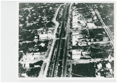 Chelsea & District Historical Society Inc
Photograph - Aerial Photo of Chelsea, c 1923
... ...Nepean Highway...Street in photo are Station Street, Chelsea Road, Nepean Highway, Thames Promenade, Bath Street and The Strand. ...Street in photo are Station Street, Chelsea Road, Nepean Highway, Thames Promenade, Bath Street and The Strand. ...Points of interest in the photo are Fox Theatre in Station Street and Masons Theatre on the corner of Chelsea Road and Station Street; Chelsea Railway Station with a goods train going past. Street in photo are Station Street, Chelsea Road, Nepean Highway, Thames Promenade, Bath Street and The Strand. Black and white aerial photo of Chelsea. chelsea, aerial photo, station street, chelsea road, the strand, bath street, fox theatre, masons theatre, chelsea railway station, thames promenade, nepean highway -
 Bayside Gallery - Bayside City Council Art & Heritage Collection
Photograph, Department of Crown Lands and Survey, Victoria, Brighton, Brighton East and Bentleigh, c. 1965-71
... ...nepean highway...The main roads shown include Centre Road at the top, Hampton Street on the left, a section of Nepean Highway diagonally across the right and South Road at the bottom....The main roads shown include Centre Road at the top, Hampton Street on the left, a section of Nepean Highway diagonally across the right and South Road at the bottom. ...The Department of Crown Lands and Survey (1857-1983) was responsible for the administration of survey and mapping and the sale, occupation and management of crown land throughout its existence. This aerial photograph shows parts of Brighton and Brighton East and was taken circa 1965-71.brighton, department of crown lands and survey, aerial photograph, bayside, port phillip bay, map, cartographic material, brighton east, dendy park, dendy street, centre road, nepean highway, south road, brighton golf course, golf -
City of Moorabbin Historical Society (Operating the Box Cottage Museum)
Booklet - Church of St Matthew Cheltenham Souvenir Diamond Jubilee (of current building) 1867 - 1927, 1927
... ...Nepean Highway...St Matthew's Church of England was erected in Cheltenham beside the Nepean Highway near Charman Road. The early settlers established a tennis club, cricket team and social groups....St Matthew's Church of England was erected in Cheltenham beside the Nepean Highway near Charman Road. The early settlers established a tennis club, cricket team and social groups. ...St Matthew's celebrated it Silver Jubilee in September 1927 with Church Services and social gatherings, a concert, a social and a dance. St Matthew's Church of England was erected in Cheltenham beside the Nepean Highway near Charman Road. The early settlers established a tennis club, cricket team and social groups.St Matthew's Church of England Cheltenham was erected in 1867 and was integral to the spiritual well being and social life of the early settlers.Souvenir booklet of text and pictures produced for the Diamond Jubilee for the St Matthew's Church of England, Cheltenham - 18 pagesst. matthew's church of england cheltenham, anglican church, early settlers, parish of moorabbin, city of moorabbin, county of bourke, shire of moorabbin, were j.b., market gardeners, cheltenham, charman road, nepean highway -
 Chelsea & District Historical Society Inc
Photograph - Captain Lonsdale's Cottage, At Carrum
... ...Nepean Highway...Alexander and put up as a beach house in Point Nepean Road (Nepean Highway). In 1959, the cottage was removed from Carrum and was recovered by the National Trust....Alexander and put up as a beach house in Point Nepean Road (Nepean Highway). In 1959, the cottage was removed from Carrum and was recovered by the National Trust. ...The cottage was built for Captain William Lonsdale (1799-1864), the first Police Magistrate of Melbourne. The cottage was built by the Royal Engineers in Sydney and flat packed to Melbourne in 1837, erected at Jolimont. In 1891 the cottage had to be removed to make way for the Jolimont Railway. It was bought by A. M. Alexander and put up as a beach house in Point Nepean Road (Nepean Highway). In 1959, the cottage was removed from Carrum and was recovered by the National Trust.Newspaper cutting, picture of Captain Lonsdale's Cottage, when it was situated in Point Nepean Road, Carrumcottage, beach house, nepean highway, point nepean road, captain lonsdale, carrum -
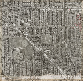
 Bayside Gallery - Bayside City Council Art & Heritage Collection
Photograph, Department of Crown Lands and Survey, Victoria, Brighton, Elwood and Elsternwick, c. 1965-71
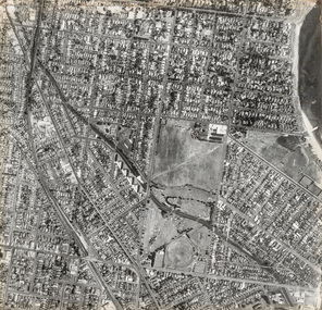
... ...Nepean Highway...The main roads shown include North Road at the top, Nepean Highway on the left, St Kilda Street on the right and Glen Huntly Road at the bottom....The main roads shown include North Road at the top, Nepean Highway on the left, St Kilda Street on the right and Glen Huntly Road at the bottom. ...The Department of Crown Lands and Survey (1857-1983) was responsible for the administration of survey and mapping and the sale, occupation and management of crown land throughout its existence. This aerial photograph shows parts of Brighton, Elwood and Elsternwick and was taken circa 1965-71.brighton, department of crown lands and survey, aerial photograph, bayside, port phillip bay, map, cartographic material, elwood, elsternwick, elsternwick park, elwood tram depot, elwood pier, new street, glen huntly road, st kilda street, nepean highway