Showing 97 items matching "parwan"
-
 Bacchus Marsh & District Historical Society
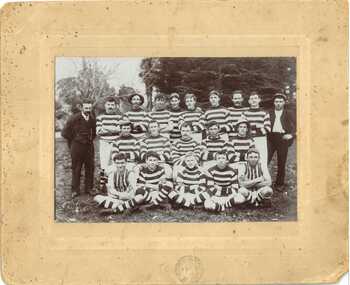
Photograph, A.E. Beseler, Parwan Football Club
... Parwan Football Club...Parwan Football Club was formed in May 1912. ...Under the paper, hand-written in blue ink: PARWAN FOOTBALL CLUB...Bacchus Marsh & District Historical Society Lerderderg Library Main Street Bacchus Marsh Parwan Football Club was formed in May 1912. ...Parwan Football Club was formed in May 1912. The specific date of this photo is not given, but it is likely that it was taken between 1912 and 1914, when the football competition was suspended. This photo is one of the oldest known photographic records of an Australian Rules football team in the Bacchus Marsh area. Australian Rules football was played in this area as early as the 1870s. An organized competition to play regular matches was formed in the early years of the twentieth century. This item has historic and social significance as an image of one of the early sporting teams of Bacchus Marsh and district. It is a typical example of team photographs of this era. It is evidence of the transition of football from a social informal setting to an organised activity and signals the growth of importance of sport, in this case Australian Rules football, as a cultural and social activity central to the Australian ethos. A sepia photograph print mounted on mounting board, showing a group of 20 men arranged in three rows. Two men, standing at either end of the group, are wearing street clothes. The remaining men are wearing a uniform of striped guernseys, white knickerbockers, knee high socks and lace up boots. Two of the men are wearing front-laced guernseys. Three are wearing striped caps, which could be part of the uniform, two a flat cap and two are wearing brimmed hats. There is a consistency in the uniform they are wearing, indicating that team sport is becoming more organised.On the front, a circular professional stamp reading: PHOTO ARTIST BACCHUS MARSH. A. BESELER. On the reverse: A white paper rectangle pasted onto the board, with hand-written notations: Back - with numbers 1-10. Against no.1 Doherty. Against no. 3 Dodemaide. Middle_ numbers 1-5. Front_ numbers 1-5. Under the paper, hand-written in blue ink: PARWAN FOOTBALL CLUBaustralian rules football, parwan football club -
 Bacchus Marsh & District Historical Society
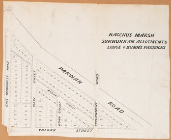
Map, Bacchus Marsh Suburban Allotments Parwan Road Lodge & Dunn's Paddocks 1888
... Bacchus Marsh Suburban Allotments Parwan Road Lodge & Dunn's Paddocks 1888...A single page paper map showing allotments of land for sale along the Parwan Road in Maddingley. The map is pasted into a bound volume containing 76 maps or plans in total. ...Bacchus Marsh Suburban Allotments Parwan Road Lodge & Dunn's Paddocks 1888 Map Shire of Bacchus Marsh ...This map was created as a plan for an auction of land close to the Bacchus Marsh Railway Station. The auction took place on 23 October 1888. 102 allotments of land from an area known as Lodge and Dunn's paddocks was offered for sale. A single page paper map showing allotments of land for sale along the Parwan Road in Maddingley. The map is pasted into a bound volume containing 76 maps or plans in total. High resolution digital image stored on BMDHS computer network. land sales bacchus marsh, land sales maddingley, bacchus marsh victoria maps, maddingley victoria maps -
 Bacchus Marsh & District Historical Society
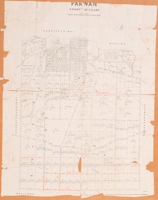
Map, Parwan Parish Map, County of Grant, 1909
... Parwan Parish Map, County of Grant, 1909...A single page paper map showing the map for the Parish of Parwan in the County of Grant. A cadastral map showing parish boundaries and land ownership. ...Bacchus Marsh & District Historical Society Lerderderg Library Main Street Bacchus Marsh Bacchus Marsh Region Parish Plans Parwan Parish Maps Parwan Parish Plan Photo-lithographed at the Department of Lands and Survey, Melbourne by T.F. ...A single page paper map showing the map for the Parish of Parwan in the County of Grant. A cadastral map showing parish boundaries and land ownership. The map is pasted into a bound volume containing 76 maps or plans in total. High resolution digital image stored on BMDHS computer network. Photo-lithographed at the Department of Lands and Survey, Melbourne by T.F. McGauran, 7.7.09. bacchus marsh region parish plans, parwan parish maps, parwan parish plan -
 Bacchus Marsh & District Historical Society
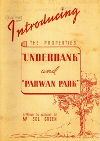
Booklet, Introducing the Properties Underbank and Parwan Park offering on account of Mr Sol Green
... Introducing the Properties Underbank and Parwan Park offering on account of Mr Sol Green...Facsimile reproduction of a real estate booklet originally produced in 1947 by Sands and McDougall Pty Ltd for sale of the Underbank and Parwan Park properties in Bacchus Marsh. Facsimile reprint of original publication. ...BMDHS Location: AR/SU4 Introducing the Properties Underbank and Parwan Park offering on account of Mr Sol Green Booklet ...Solomon (Sol) Green was a major bookmaker, businessman, real estate investor, racehorse owner and trainer, and philanthropist. His connection to Bacchus Marsh was through his ownership of the Underbank Stud property which he purchased in 1924. He also owned the Parwan Park property for some time. Both of these properties were put up for sale in 1947 just a year before the death of Sol Green in 1948.Stapled printed softcover booklet. 20 pages. 200mm x 290mm. Facsimile reproduction of a real estate booklet originally produced in 1947 by Sands and McDougall Pty Ltd for sale of the Underbank and Parwan Park properties in Bacchus Marsh. Facsimile reprint of original publication. Date of reprint copy c.2022. Original copy, printed 1947, is also held by Bacchus Marsh and District Historical Society. BMDHS Location: AR/SU4non-fictionSolomon (Sol) Green was a major bookmaker, businessman, real estate investor, racehorse owner and trainer, and philanthropist. His connection to Bacchus Marsh was through his ownership of the Underbank Stud property which he purchased in 1924. He also owned the Parwan Park property for some time. Both of these properties were put up for sale in 1947 just a year before the death of Sol Green in 1948. solomon green 1868-1948, bookmakers, parwan park, underbank stud, land sales bacchus marsh -
 Bacchus Marsh & District Historical Society
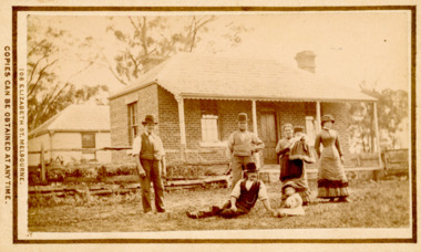
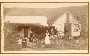
Photograph, Tom Oliver and family at Woodside, Parwan 1883
... Tom Oliver and family at Woodside, Parwan 1883...Thomas Oliver, a farmer, advocated for a school at Parwan near Bacchus Marsh. This image depicts him and members of his family at his property, Woodside in 1883. ...Tom Oliver and family at Woodside, Parwan 1883 Photograph ...The family in this photograph is believed to be the Oliver family. Thomas Oliver, a farmer, advocated for a school at Parwan near Bacchus Marsh. This image depicts him and members of his family at his property, Woodside in 1883. The Woodside property was formerly owned by John Cook. The Olivers lived at Woodside during the 1870s and 1880s. Thomas Oliver retired around 1888 and moved to 'Elam's Cottage' in Bacchus Marsh. Three months after moving to Bacchus Marsh he died.Small sepia unframed photograph on card with gold border framing photograph. Housed in the album, 'Photographs of Bacchus Marsh and District in 1883 by Stevenson and McNicoll'. An image depicting a family group in front of a farm house. There are three men, two women and two small children standing or lying on a grassed area in front of the house, which has a post-and-rail fence. The farmhouse is a simple rectangular- shaped brick house with two chimneys and a tiled or slate roof. Behind the house can be seen a second building, also one-storeyed with a tiled or slate hip roof. On the front: Stevenson & McNicoll. Photo. 108 Elizabeth St. Melbourne. COPIES CAN BE OBTAINED AT ANY TIME. On the back: LIGHT & TRUTH inscribed on a banner surmounted by a representation of the rising sun. Copies of this Portrait can be had at any time by sending the Name and Post Office Money Order or Stamps for the amount of order to STEVENSON & McNICOLL LATE BENSON & STEVENSON, Photographers. 108 Elizabeth Street, MELBOURNE. stevenson and mcnicoll 1883 photographs of bacchus marsh and district, farms, farmers, oliver family parwan vic. -
 Bacchus Marsh & District Historical Society
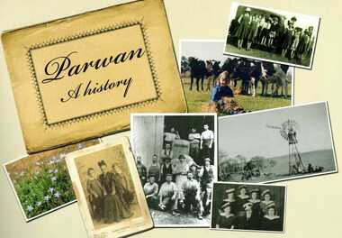
Book, Parwan: A History, 2010
... Parwan: A History...Includes a separate folded sheet inside a pocket which has a reproduction of a map of the Parwan Parish in the County of Grant. On the reverse of this sheet are two reproductions. ...Citation: Parwan: A History by Dianne Van Leuvan. Published by Parwan History Group, Bacchus Marsh, Vic., 2010. ...Explores the history of the small farming community on the outskirts of Bacchus Marsh. It contains a plethora of fascinating details about the early years of this farming community from the 1830s until the early 2000s. There is a brief section at the beginning which looks at the history of the area prior to the colonial era. The book contains numerous sections about families and individual people who have lived in the Parwan area and includes many images of places and people. Citation: Parwan: A History by Dianne Van Leuvan. Published by Parwan History Group, Bacchus Marsh, Vic., 2010.Paperback printed book. 128 pages. with illustrations and photographs, some coloured. Includes facsimiles, maps, and index. Includes a separate folded sheet inside a pocket which has a reproduction of a map of the Parwan Parish in the County of Grant. On the reverse of this sheet are two reproductions. One is a land auction plan for February 1910 advertising the sale of portions of land from the Nerowie Estate. The other reproduction is a section of a map showing some of the blocks of land in the Nerowie Estate which has the heading, 'Nerowie Titles 1898'. A pocket inside the back cover contains a separate booklet which is an index, and two pages of 'Additional Information'.non-fictionExplores the history of the small farming community on the outskirts of Bacchus Marsh. It contains a plethora of fascinating details about the early years of this farming community from the 1830s until the early 2000s. There is a brief section at the beginning which looks at the history of the area prior to the colonial era. The book contains numerous sections about families and individual people who have lived in the Parwan area and includes many images of places and people. Citation: Parwan: A History by Dianne Van Leuvan. Published by Parwan History Group, Bacchus Marsh, Vic., 2010.parwan vic. history -
 Victorian Interpretive Projects Inc.
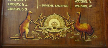
Parwan State School (916) World War One Honour Board, 2014
... Parwan State School (916) World War One Honour Board, 2014...parwan...Watson; W. Watson. Parwan State School (916) World War One Honour Board, 2014 ...This honor roll is held by the Bacchus Marsh RSLThe names on the honour board are: W. Blake; F.G. Blake; A.K. Cumming; A.V. Chapple; W.J. Cocherill; A.P. Cecil; C.R. Edwards; W.B. Edwards; R.W. Edwards; T. Hawkins; R.J. Lindsay; D.S. Lindsay; C.D. Cumming; N.H. Cumming; T.L. Cocherill; W.F. Hehir; N. McLachlan; J. McLachlan; S. Osborne; E.A. Smith; A. Ladhams; T. Phillips; J.A. Sweetman; R.H. Serjeant; W.T. Serjeant; T. Shannon; P. Triggs; C.M. Todd; M. Whelan; R. Watson; W. Watson.parwan, parwan state school, world war, world war 1, honour board, honor board, blake, cumming, chapple, cocherill, cecil, edwards, hawkins, lindsay, hehr, mclachlan, osborne, smith, ladhams, philips, sweetman, serjeant, shannon, triggs, todd, whelan, watson, bacchus marsh rsl, mmm -
 Bacchus Marsh & District Historical Society
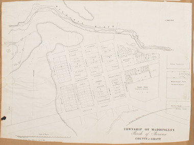
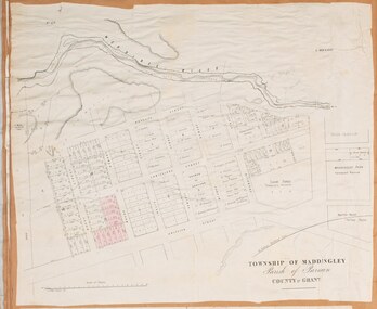
Map, Maddingley Township, Parish of Parwan, 1880s
... Maddingley Township, Parish of Parwan, 1880s ...Maddingley Township, Parish of Parwan, 1880s Map Shire of Bacchus Marsh ...This map is dated Sept. 6th 1856. However places in the township of Maddingley which did not appear until the late 1880s such as the Bacchus Marsh Railway Station and line are shown on this map in their correct locations. This suggests the map has been derived from an earlier map. An earlier date of 1843 with a surveyor's name preceding it can also be seen on the map. The map is important because it indicates the location and dimensions of early but now discontinued use of land such as the showgrounds and police paddock and a site reserved for the Church of England which was not ultimately used for a permanent church. A single page paper map showing land allotments, streets, rivers, creeks, park lands, the railway line and Bacchus Marsh railway station in the township of Maddingley. The map is pasted into a bound volume containing 76 maps or plans in total. Bottom of Map: Surveyor-General's Office, Melbourne, Sept 6th, 1856bacchus marsh victoria maps, maddingley victoria maps, land use, maddingley victoria history -
 Bacchus Marsh & District Historical Society
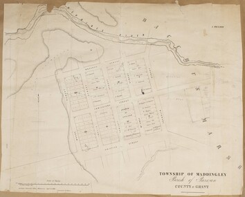
Map, Maddingley Township, Parish of Parwan, circa 1890s
... Maddingley Township, Parish of Parwan, circa 1890s...Maddingley Township, Parish of Parwan, circa 1890s Map Shire of Bacchus Marsh ...Maddingley is a locality or township within the broader township area of Bacchus Marsh. This map is not dated. However features in Maddingley which appeared in the 1880s and 1890s are present in the map, These include the Bacchus Marsh Railway Station and the Bacchus Marsh Showgrounds. The main residential and commercial area of Maddingley is shown on this map in an area bounded by Bacchus Street, Barry Street, Griffith Street and Maddingley Road. Other streets visible are Franklin Street, Inglis Street, Labilliere Street, McCrae Street, Moore Street and part of Station Street.A single page paper map showing land allotments, streets, rivers, creeks, park lands, the railway line and Bacchus Marsh railway station in the township of Maddingley. The map is pasted into a bound volume containing 76 maps or plans in total. bacchus marsh victoria maps, maddingley victoria maps, land use, maddingley victoria history -
 Bacchus Marsh & District Historical Society
Map, Maddingley Township, Parish of Parwan, County of Grant, 1856
... Maddingley Township, Parish of Parwan, County of Grant, 1856...Maddingley Township, Parish of Parwan, County of Grant, 1856 Map Shire of Bacchus Marsh ...Maddingley is a locality or township within the broader township area of Bacchus Marsh. This map is dated 1856 but is based on an earlier survey in 1843. The main area of Maddingley shown on this map is an area bounded by Bacchus Street, Moore Street, Griffith Street and Franklin Street. Other streets visible are Inglis Street, Labilliere Street, McCrae Street. The area to the east of Franklin Street is not sub-divided and is described as an 'alluvial flat. A single page paper map showing land allotments, streets, and natural watercourses in the township of Maddingley. The map is pasted into a bound volume containing 76 maps or plans in total. Two inscriptions: 1. A.J. Skene Surveyor, 1843. ; 2. Surveyor-General's Office Melbourne, Sept 6, 1856. (Lithographed by R. Meikle)bacchus marsh victoria maps, maddingley victoria maps, land use, maddingley victoria history -
 Federation University Historical Collection
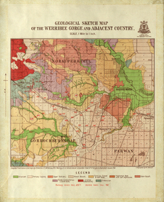
Map, Geological Sketch Map of the Werribee Gorge and Adjacent Country, 1914, 1914
... ...parwan...A coloured geological sketch map of the Werribee Gorge, Bacchus Marsh, Rowlesy, Darley, Parwan. The scale is 1 mile to 1 inch...Barker Library (top floor) Mount Helen goldfields werribee gorge bacchus marsh darley parwan w.e. bennett bennett r.a.f. murray c.c. brittlebank rowsley A coloured geological sketch map of the Werribee Gorge, Bacchus Marsh, Rowlesy, Darley, Parwan. ...A coloured geological sketch map of the Werribee Gorge, Bacchus Marsh, Rowlesy, Darley, Parwan. The scale is 1 mile to 1 inchwerribee gorge, bacchus marsh, darley, parwan, w.e. bennett, bennett, r.a.f. murray, c.c. brittlebank, rowsley -
 Bacchus Marsh & District Historical Society
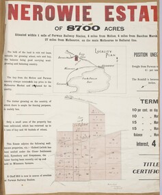
Map, Nerowie Estate Land Sale 1910
... The Nerowie Estate was a large rural property of 8,700 acres (3520 hectares) near the locality of Parwan only a few kilometers east of Bacchus Marsh. ...A single page paper map showing the land offered for sale from the Nerowie Estate at Parwan near Bacchus Marsh in 1910. The map is pasted into a bound volume containing 76 maps or plans in total. ...It had once formed a large part of the land owned by the pioneering Staughton family. Nerowie Estate Parwan Land Sales Parwan Land Sales Bacchus Marsh Staughton Family Bacchus Marsh A single page paper map showing the land offered for sale from the Nerowie Estate at Parwan near Bacchus Marsh in 1910. ...The Nerowie Estate was a large rural property of 8,700 acres (3520 hectares) near the locality of Parwan only a few kilometers east of Bacchus Marsh. It had once formed a large part of the land owned by the pioneering Staughton family.A single page paper map showing the land offered for sale from the Nerowie Estate at Parwan near Bacchus Marsh in 1910. The map is pasted into a bound volume containing 76 maps or plans in total. High resolution digital image stored on BMDHS computer network. nerowie estate parwan, land sales parwan, land sales bacchus marsh, staughton family bacchus marsh -
 Bacchus Marsh & District Historical Society
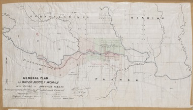
Map, General Plan for Water Supply Works, Shire of Bacchus Marsh 1887
... The plan includes the route of a proposed water channel in the Parwan area, and other features of water supply infrastructure such as the location of standpipes and gates are also shown on the plan....A single page paper map showing a general plan for the supply of water in the Bacchus Marsh area.The plan shows the route of the 'Main Channel' near the Werribee River and a proposed route for a Parwan Channel. The location of 'Dryden's House' near the Werribee River is also shown and the locations of land held by T. ...The plan includes the route of a proposed water channel in the Parwan area, and other features of water supply infrastructure such as the location of standpipes and gates are also shown on the plan. ...Debate about water supply and its planning and development took place in the Bacchus Marsh region from the 1850s through into the twentieth century. This plan was part of documentation to support an application for an additional loan of money from the Ministry of Water Supply to the Bacchus Marsh Shire Water Supply Trust. The plan includes the route of a proposed water channel in the Parwan area, and other features of water supply infrastructure such as the location of standpipes and gates are also shown on the plan.A single page paper map showing a general plan for the supply of water in the Bacchus Marsh area.The plan shows the route of the 'Main Channel' near the Werribee River and a proposed route for a Parwan Channel. The location of 'Dryden's House' near the Werribee River is also shown and the locations of land held by T. (Tom) Oliver and the Racecourse Reserve in Maddingley. Scale 40 chains to 1 inch. The plan is signed by Bacchus Marsh Shire Engineer, W.E. Standfield. The map is pasted into a bound volume containing 76 maps or plans in total. High resolution digital image stored on BMDHS computer network. General Plan of Water Supply Works in the Shire of Bacchus Marsh. Accompanying application for 2nd additional Loan. Original Waterworks district. Additional area. W.E. Standfield, 30/8/87.water supply, water supply maps, water supply bacchus marsh, irrigation, bacchus marsh victoria maps -
 Bacchus Marsh & District Historical Society
Photograph, Group of women at a farmhouse near Bacchus Marsh 1883
... This property has been identified as that of John Tilley at Parwan’s Creek. The people depicted are presumably members of the Tilley family. ...The property has been identified as that of John Tilley at Parwan’s Creek. This property has since been demolished. ...This property has been identified as that of John Tilley at Parwan’s Creek. The people depicted are presumably members of the Tilley family. ...This image is one of several family group portraits taken by Stevenson and McNicoll on rural properties. This property has been identified as that of John Tilley at Parwan’s Creek. The people depicted are presumably members of the Tilley family. The dwelling has since been demolished. Tilleys Road in Maddingley is probably named for this family farm.Small sepia unframed photograph on card with gold border framing photograph. Housed in the Jeremeas Family Album which contains photographs of Bacchus Marsh and District in 1883 by Stevenson and McNicoll. The property has been identified as that of John Tilley at Parwan’s Creek. This property has since been demolished. Presumably, the photo is of members of the Tilley family. The image shows a family group of four women and one young child. It is unclear if the child is a boy or a girl, due to the custom of clothing young male children in dresses. The women are sitting or standing in two groups. To the right stands an older woman in a starched white apron, perhaps indicating that she is the housekeeper. The group on the left is of one woman standing and two women seated, one reading a newspaper or magazine. The young child reaches out one arm to her, perhaps for reassurance. The dwelling consists of two structures, one single storeyed cottage, which is perhaps the older part, and an adjoining weatherboard house with a steeply pitched roof and a prominent chimney at the front. The cottage has a shingled verandah partially covered by corrugated iron, which also covers the roof. Trees, a climbing vine and shrubs form a rather unkempt garden. On the hill rising behind the farmhouse there can be seen animals, possibly sheep, grazing.On the front: Stevenson & McNicoll. Photo. 108 Elizabeth St. Melbourne. COPIES CAN BE OBTAINED AT ANY TIME. On the back: LIGHT & TRUTH inscribed on a banner surmounted by a representation of the rising sun. Copies of this Portrait can be had at any time by sending the Name and Post Office Money Order or Stamps for the amount of order to STEVENSON & McNICOLL LATE BENSON & STEVENSON, Photographers. 108 Elizabeth Street, MELBOURNE. stevenson and mcnicoll 1883 photographs of bacchus marsh and district, farmhouses, families, women bacchus marsh -
 Bacchus Marsh & District Historical Society
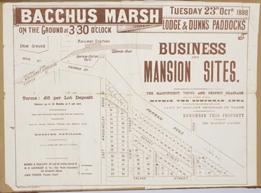
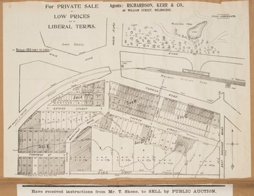
Map, Bacchus Marsh Tuesday 23rd Oct. 1888, Lodge & Dunn's Paddocks 1888. Business and Mansion Sites
... A single page paper map showing allotments of land for sale along the Parwan Road in Maddingley. The map is pasted into a bound volume containing 76 maps or plans in total. ...A single page paper map showing allotments of land for sale along the Parwan Road in Maddingley. The map is pasted into a bound volume containing 76 maps or plans in total. ...This map was created as a plan for an auction of land close to the Bacchus Marsh Railway Station. The auction took place on 23 October 1888. 102 allotments of land from an area known as Lodge and Dunn's paddocks was offered for sale. The auction was conducted by auctioneers based in Melbourne and was advertised in Melbourne newspapers as well as in the Bacchus Marsh Express newspaper. The auction plan contains a range of details including the selling agents, Munro and Baillieu; W.P. Lockhart; and John Turner, all of Melbourne, deposit terms for purchases, price of railway passes for a return trip from Melbourne to Bacchus Marsh of 1 shilling, and a description of the land as having 'magnificent views and perfect drainage'. A single page paper map showing allotments of land for sale along the Parwan Road in Maddingley. The map is pasted into a bound volume containing 76 maps or plans in total. High resolution digital image stored on BMDHS computer network. At bottom on left side: 'Harston & Co. Lith, Melb.'land sales bacchus marsh, land sales maddingley, bacchus marsh victoria maps, maddingley victoria maps -
 Bacchus Marsh & District Historical Society
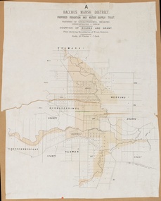
Map, Bacchus Marsh District (A). Proposed Irrigation and Water Supply Trust. Plan shewing boundaries of Trust District
... The District lies within the Parishes of Korkuperrimul, Merrimu, Parwan and Gorrockburkchap in the Counties of Bourke and Grant. ...The District lies within the Parishes of Korkuperrimul, Merrimu, Parwan and Gorrockburkchap in the Counties of Bourke and Grant. ...The 1886 Irrigation Act in Victoria introduced the first legislation in Australia designed to enable the creation of a detailed scheme for agricultural irrigation. Part of the legislation saw the use of government funds for local irrigation projects. These local projects were managed by local irrigation trusts. The Bacchus Marsh Irrigation and Water Supply Trust was formed in 1889. This map depicts the proposed area of the Trust.Printed paper map of the proposed Bacchus Marsh Irrigation and Water Supply district. Circa 1889. Plan showing boundaries of Trust District. The District lies within the Parishes of Korkuperrimul, Merrimu, Parwan and Gorrockburkchap in the Counties of Bourke and Grant. At the top of the map above its title is the letter 'A; in capital lettering. Scale: 40 Chains = 1 inch.irrigation, water supply, bacchus marsh irrigation and water supply trust -
 National Wool Museum
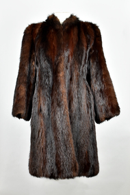
Textile - Fox Fur Coat, Nettlebergs Pty. Ltd, 1950
... ...Parwan...One was Greystones at Glenmore, owned by the O'Keith family and the other was at Parwan, owned by the Miles Family. In the late 1940's and early 1950's, the Government put a bounty on the fox head. ...One was Greystones at Glenmore, owned by the O'Keith family and the other was at Parwan, owned by the Miles Family. In the late 1940's and early 1950's, the Government put a bounty on the fox head. ..."The foxes were shot in the 1950's by my Father, Charles Winnet Daniel Allen at two properties around Bacchus Marsh. One was Greystones at Glenmore, owned by the O'Keith family and the other was at Parwan, owned by the Miles Family. In the late 1940's and early 1950's, the Government put a bounty on the fox head. A pair of ears were sent to the Council and you were paid 2 pennies and the skins were sold to a skin buyer. My Father would go out on moon lit nights and shoot the foxes then skin them, which he would peg on a board to dry. He took 21 fox skins to Nettlebergs Pty. Ltd., Furriers at 173 Elizabeth Street Melbourne, Victoria, to have this coat made for my Mother, Gladys Eileen Allen. It cost Twenty Pound and Nine Shillings to have the skins made into this coat. My Father died on the 1st July 1982 and my Mother on the 15th October 1993, aged 76. This coat was inherited by me Theresa Joy Hodge (nee Allen) on the passing of my Mother. I have worn it on cold days, but seeing that I am 84 and the coat is 74 years old, I would like to donate it to you, as I have no-one to leave it to and hope that you and the visitors to your Museum will enjoy looking at it." Theresa Hodge, 2025 Theresa was a dairy farmer, who grew up in Bacchus Marsh with her parents, before moving to South Australia in 1980 to a 167 acre farm in Burrungale.Dark brown fox fur coat with silk lining. Three eye and hook clasps at front edges of coat.fox fur coat, fashion, hunting, pest eradication, farming, rural life, bacchus marsh, greystones, glenmore, parwan, fox, nettlebergs pty ltd, furriers, clothing, theresa hodge, charles allen, gladys allen -
 Bacchus Marsh & District Historical Society
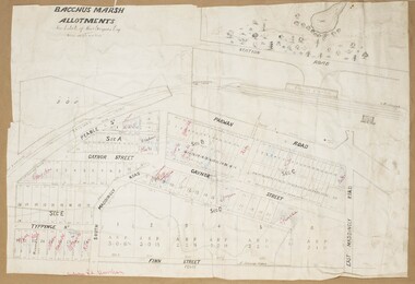
Map, Gaynor Street Land Sales, Maddingley, circa 1880s-1890s
... Locations shown include Gaynor Street, Maddingley Road South, Parwan Road, Mitchem Street, Typpynge Street, Finn Street and East Maddingley Road. . ...Locations shown include Gaynor Street, Maddingley Road South, Parwan Road, Mitchem Street, Typpynge Street, Finn Street and East Maddingley Road. . ...This map was produced for a major sale of land in the Maddingley area of Bacchus Marsh. The precise date of the sale has not been determined. Features present on the map such as the Bacchus Marsh Railway Station indicate the land sale must have taken place some time after 1887 when the Railway Station opened. A single page paper map showing land allotments for sale in the Maddingley area of Bacchus Marsh. Locations shown include Gaynor Street, Maddingley Road South, Parwan Road, Mitchem Street, Typpynge Street, Finn Street and East Maddingley Road. . The map is pasted into a bound volume containing 76 maps or plans in total. High resolution digital image stored on BMDHS computer network. bacchus marsh victoria maps, maddingley victoria maps, land use, maddingley victoria history, land sales bacchus marsh, land sales maddingley -
 Bacchus Marsh & District Historical Society
Map, Gaynor Street Area Land Sales, Maddingley, 1888
... Locations shown include Gaynor Street, Maddingley Road South, Parwan Road, Mitchem Street, Typpynge Street, Finn Street and East Maddingley Road. . ...Locations shown include Gaynor Street, Maddingley Road South, Parwan Road, Mitchem Street, Typpynge Street, Finn Street and East Maddingley Road. . ...This map was produced for a major sale of land in the Maddingley area of Bacchus Marsh in 1888. The sale was conducted by two firms from Melbourne, Carney and Kelly 12 Swanston Street Melbourne. and 'Richardson, Kerr & Co. 40 Flinders Lane Melbourne. 136 blocks were for sale.A single page paper map showing land allotments for sale in the Maddingley area of Bacchus Marsh. Locations shown include Gaynor Street, Maddingley Road South, Parwan Road, Mitchem Street, Typpynge Street, Finn Street and East Maddingley Road. . The map is pasted into a bound volume containing 76 maps or plans in total. High resolution digital image stored on BMDHS computer network. bacchus marsh victoria maps, maddingley victoria maps, land use, maddingley victoria history, land sales bacchus marsh, land sales maddingley -
 Bacchus Marsh & District Historical Society
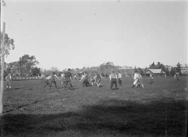
Photograph, Football Match at Maddingley Park Bacchus Marsh 1900s
... The other team is possibly Parwan. The style of uniforms suggest the date of the photo is from around 1910 or possibly a few years earlier. ...The other team is possibly Parwan. The style of uniforms suggest the date of the photo is from around 1910 or possibly a few years earlier. ...This photo is a very early example of an action image from an Australian Rules football match in a rural area in Victoria. The identity of the two teams is not confirmed. The team with the dark colored uniform is probably the Bacchus Marsh football team. The other team is possibly Parwan. The style of uniforms suggest the date of the photo is from around 1910 or possibly a few years earlier. This item has particular historic and social significance as an action image of two of the early sporting teams of Bacchus Marsh and district. These type of images are very rare for teams outside of the major metropolitan competitions such as the Victorian Football League of Victorian Football Association. It therefore provides a rare and fascinating depiction of an early football game as it was played and the ground conditions in which footballers played in the early 1900s.A black and white photograph produced from a digitized glass negative held by the State Library of Victoria titled, ‘Men and boys playing football on an oval set among trees and fields’ ca. 1910, Pictures Collection, State Library Victoria, H92.433/20. The description for the image held by the State Library of Victoria does not identify the location where the image was taken. By close comparison with other images of Maddingley Park held by the Bacchus Marsh and District Historical Society the location has been identified as Maddingley Park, Bacchus Marsh. A significant identifier for this image is the presence of the Evans Pavilion in the background which was built in 1896. Trees and statues in the background on the left side of the image also match other images of Maddingley Park from this time.australian rules football, bacchus marsh football club, australian rules football action images -
 National Wool Museum
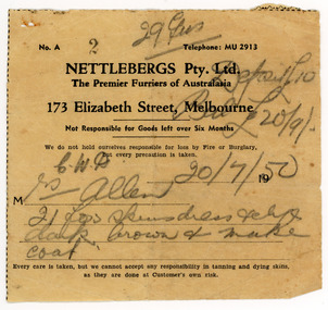
Document - Receipt, Fox Fur Coat, Nettlebergs Pty Ltd, Nettlebergs Pty. Ltd, 20/7/1950
... ...Parwan...One was Greystones at Glenmore, owned by the O'Keith family and the other was at Parwan, owned by the Miles Family. In the late 1940's and early 1950's, the Government put a bounty on the fox head. ...One was Greystones at Glenmore, owned by the O'Keith family and the other was at Parwan, owned by the Miles Family. In the late 1940's and early 1950's, the Government put a bounty on the fox head. ...This receipt is for a fox fur coat made in Melbourne in 1950 by Nettlebergs. It is associated with the fox fur coat in the National Wool Museum Collection, NWM-9090. "The foxes were shot in the 1950's by my Father, Charles Winnet Daniel Allen at two properties around Bacchus Marsh. One was Greystones at Glenmore, owned by the O'Keith family and the other was at Parwan, owned by the Miles Family. In the late 1940's and early 1950's, the Government put a bounty on the fox head. A pair of ears were sent to the Council and you were paid 2 pennies and the skins were sold to a skin buyer. My Father would go out on moon lit nights and shoot the foxes then skin them, which he would peg on a board to dry. He took 21 fox skins to Nettlebergs Pty. Ltd., Furriers at 173 Elizabeth Street Melbourne, Victoria, to have this coat made for my Mother, Gladys Eileen Allen. It cost Twenty Pound and Nine Shillings to have the skins made into this coat. My Father died on the 1st July 1982 and my Mother on the 15th October 1993, aged 76. This coat was inherited by me Theresa Joy Hodge (nee Allen) on the passing of my Mother. I have worn it on cold days, but seeing that I am 84 and the coat is 74 years old, I would like to donate it to you, as I have no-one to leave it to and hope that you and the visitors to your Museum will enjoy looking at it." Theresa Hodge, 2025 Theresa was a dairy farmer, who grew up in Bacchus Marsh with her parents, before moving to South Australia in 1980 to a 167 acre farm in Burrungale.Single sided paper receipt with black printed text and handwritten text in pencil.front: [printed] No. A / 2 / Telephone: MU 2913 / NETTLEBERGS Pty. Ltd. / The Premier Furriers of Australasia / 173 Elizabeth Street, Melbourne / Not Responsible for Goods left over Six Months / We do not hold ourselves responsible for loss by Fire or Burglary, / but every precaution is taken. / 19 / M / Every care is taken, but we cannot accept any responsibility in tanning and dying skins, / as they are done at Customer's own risk. front: [handwritten] 29 ? / Deposit £10 / Bal £20/9 / C. W. A. 20/7/50 / Mrs Allen / 21 fox skins dress pelts / dark brown + make / coatfox fur coat, fashion, hunting, pest eradication, farming, rural life, bacchus marsh, greystones, glenmore, parwan, fox, nettlebergs pty ltd, furriers, clothing, theresa hodge, charles allen, gladys allen -
 National Wool Museum
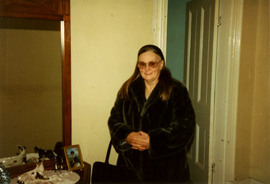
Photograph - Theresa Joy Hodge Wearing Fox Fur Coat, 1995
... ...Parwan...One was Greystones at Glenmore, owned by the O'Keith family and the other was at Parwan, owned by the Miles Family. In the late 1940's and early 1950's, the Government put a bounty on the fox head. ...One was Greystones at Glenmore, owned by the O'Keith family and the other was at Parwan, owned by the Miles Family. In the late 1940's and early 1950's, the Government put a bounty on the fox head. ...This photograph shows Theresa Joy Hodge wearing the fox fur coat her father made, which is now part of the National Wool Museum Collection, NWM-9090. "The foxes were shot in the 1950's by my Father, Charles Winnet Daniel Allen at two properties around Bacchus Marsh. One was Greystones at Glenmore, owned by the O'Keith family and the other was at Parwan, owned by the Miles Family. In the late 1940's and early 1950's, the Government put a bounty on the fox head. A pair of ears were sent to the Council and you were paid 2 pennies and the skins were sold to a skin buyer. My Father would go out on moon lit nights and shoot the foxes then skin them, which he would peg on a board to dry. He took 21 fox skins to Nettlebergs Pty. Ltd., Furriers at 173 Elizabeth Street Melbourne, Victoria, to have this coat made for my Mother, Gladys Eileen Allen. It cost Twenty Pound and Nine Shillings to have the skins made into this coat. My Father died on the 1st July 1982 and my Mother on the 15th October 1993, aged 76. This coat was inherited by me Theresa Joy Hodge (nee Allen) on the passing of my Mother. I have worn it on cold days, but seeing that I am 84 and the coat is 74 years old, I would like to donate it to you, as I have no-one to leave it to and hope that you and the visitors to your Museum will enjoy looking at it." Theresa Hodge, 2025 Theresa was a dairy farmer, who grew up in Bacchus Marsh with her parents, before moving to South Australia in 1980 to a 167 acre farm in Burrungale.Colour photograph showing an interior view of a woman wearing sunglasses and a fox fur coat. She is standing in front of a doorway, and beside a dresser which has a mirror, ornaments and a photograph.back: [handwritten] 1995 Winter / Theresa Allen back: [printed] Kodak / Official Sponsor / of the / Olympic Gamesfox fur coat, fashion, hunting, pest eradication, farming, rural life, bacchus marsh, greystones, glenmore, parwan, fox, nettlebergs pty ltd, furriers, clothing, theresa hodge, charles allen, gladys allen -
 National Wool Museum
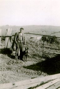
Photograph - Charles Winnet Daniel Allen, Bacchus Marsh, 1939
... ...Parwan...One was Greystones at Glenmore, owned by the O'Keith family and the other was at Parwan, owned by the Miles Family. In the late 1940's and early 1950's, the Government put a bounty on the fox head. ...One was Greystones at Glenmore, owned by the O'Keith family and the other was at Parwan, owned by the Miles Family. In the late 1940's and early 1950's, the Government put a bounty on the fox head. ...This photograph shows Theresa Joy Hodge's father Charles Winnet Daniel Allen on property in the Bacchus Marsh area, where he shot foxes which which were turned into a fox fur coat, which is now part of the National Wool Museum Collection, NWM-9090. "The foxes were shot in the 1950's by my Father, Charles Winnet Daniel Allen at two properties around Bacchus Marsh. One was Greystones at Glenmore, owned by the O'Keith family and the other was at Parwan, owned by the Miles Family. In the late 1940's and early 1950's, the Government put a bounty on the fox head. A pair of ears were sent to the Council and you were paid 2 pennies and the skins were sold to a skin buyer. My Father would go out on moon lit nights and shoot the foxes then skin them, which he would peg on a board to dry. He took 21 fox skins to Nettlebergs Pty. Ltd., Furriers at 173 Elizabeth Street Melbourne, Victoria, to have this coat made for my Mother, Gladys Eileen Allen. It cost Twenty Pound and Nine Shillings to have the skins made into this coat. My Father died on the 1st July 1982 and my Mother on the 15th October 1993, aged 76. This coat was inherited by me Theresa Joy Hodge (nee Allen) on the passing of my Mother. I have worn it on cold days, but seeing that I am 84 and the coat is 74 years old, I would like to donate it to you, as I have no-one to leave it to and hope that you and the visitors to your Museum will enjoy looking at it." Theresa Hodge, 2025 Theresa was a dairy farmer, who grew up in Bacchus Marsh with her parents, before moving to South Australia in 1980 to a 167 acre farm in Burrungale.Black and white photograph featuring a man standing on a rural property with a dog beside him. A gate, fencing and water tank are shown in the background.back: [handwritten] 1939 / Charles Winnet Daniel / Allen back: [printed] FUJIFILM / Fujicolour Crystal Archive / Paperfox fur coat, fashion, hunting, pest eradication, farming, rural life, bacchus marsh, greystones, glenmore, parwan, fox, nettlebergs pty ltd, furriers, clothing, theresa hodge, charles allen, gladys allen -
 National Wool Museum
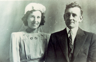
Photograph - Wedding Photo of Gladys Harris and Charles Allen, 1937
... ...Parwan...One was Greystones at Glenmore, owned by the O'Keith family and the other was at Parwan, owned by the Miles Family. In the late 1940's and early 1950's, the Government put a bounty on the fox head. ...One was Greystones at Glenmore, owned by the O'Keith family and the other was at Parwan, owned by the Miles Family. In the late 1940's and early 1950's, the Government put a bounty on the fox head. ...This photograph shows Charles Winnet Daniel Allen and Gladys Eileen Harris on their wedding day, 18th December 1937. This photographs relates to the fox fur coat which is now part of the National Wool Museum Collection, NWM-9090. "The foxes were shot in the 1950's by my Father, Charles Winnet Daniel Allen at two properties around Bacchus Marsh. One was Greystones at Glenmore, owned by the O'Keith family and the other was at Parwan, owned by the Miles Family. In the late 1940's and early 1950's, the Government put a bounty on the fox head. A pair of ears were sent to the Council and you were paid 2 pennies and the skins were sold to a skin buyer. My Father would go out on moon lit nights and shoot the foxes then skin them, which he would peg on a board to dry. He took 21 fox skins to Nettlebergs Pty. Ltd., Furriers at 173 Elizabeth Street Melbourne, Victoria, to have this coat made for my Mother, Gladys Eileen Allen. It cost Twenty Pound and Nine Shillings to have the skins made into this coat. My Father died on the 1st July 1982 and my Mother on the 15th October 1993, aged 76. This coat was inherited by me Theresa Joy Hodge (nee Allen) on the passing of my Mother. I have worn it on cold days, but seeing that I am 84 and the coat is 74 years old, I would like to donate it to you, as I have no-one to leave it to and hope that you and the visitors to your Museum will enjoy looking at it." Theresa Hodge, 2025 Theresa was a dairy farmer, who grew up in Bacchus Marsh with her parents, before moving to South Australia in 1980 to a 167 acre farm in Burrungale.Black and white photograph a man and a woman standing together. The woman is wearing a wedding gown and headpiece, and the man is wearing a suit.back: [handwritten] Wedding Photo of Gladys Harris / and Charles Allen 1937 / 17-3-1994 / 18-12-37 / Church of England / 18-12-1937 / ORIGINAL: / a. Surmon back: [printed] ALLEYNE HOCKLEY / 12 WILKIE STREET / CASTLEMAINE 3450 / Phone 721425 back: [printed] Kodak / PAPERfox fur coat, fashion, hunting, pest eradication, farming, rural life, bacchus marsh, greystones, glenmore, parwan, fox, nettlebergs pty ltd, furriers, clothing, theresa hodge, charles allen, gladys allen, wedding -
![Map, Liquidator's sale, 1896. [Woolpack Estate, Bacchus Marsh]](/media/collectors/5e461d8021ea67224c82f2a1/items/6779ee97032b72846b5995f2/item-media/6779ef33032b72846b599b30/item-fit-380x285.jpg?cb=6) Bacchus Marsh & District Historical Society
Bacchus Marsh & District Historical SocietyMap, Liquidator's sale, 1896. [Woolpack Estate, Bacchus Marsh]
... Also shown on the map are lots for sale at Robinson's Farm on Coimadai Creek and allotments near Bacchus Marsh railway station, including lots on Government Road (East Maddingley Road), View Street and Government Road (Parwan Road). No scale provided. The map is pasted into a bound volume containing 76 maps or plans in total. ...Also shown on the map are lots for sale at Robinson's Farm on Coimadai Creek and allotments near Bacchus Marsh railway station, including lots on Government Road (East Maddingley Road), View Street and Government Road (Parwan Road). No scale provided. The map is pasted into a bound volume containing 76 maps or plans in total. ...The Woolpack Estate was an area of land owned by various landowners in the Bacchus Marsh area since the early Colonial period of the 1840s. The area was located on the eastern side of the Bacchus Marsh township about 7 kilometers from the town. The Lerderderg River ran through part of the land and so did the Melbourne to Ballarat Road. The historic Woolpack Inn associated with James Crook was also located on this land. By 1896 150 acres of this land was under the control of liquidators for the Federal Bank of Australasia who instructed that the land be sub-divided and sold in lots by public auction. A successful sale was held on 24 June 1896. Most of the blocks of land were sold for higher than expected prices and most of the buyers were people from the town and district of Bacchus Marsh. The map includes various details about the land which is described on the map as an "important sale of rich alluvial irrigable flat land in the Bacchus Marsh Valley, and other properties". The auction was conducted by the local agents W. Anderson and Bence in conjunction with Pearce Brothers also of Bacchus Marsh.A single page paper map showing a plan of 150 acres of land from the Woolpack Estate to be sold in various lots in June 1896. Also shown on the map are lots for sale at Robinson's Farm on Coimadai Creek and allotments near Bacchus Marsh railway station, including lots on Government Road (East Maddingley Road), View Street and Government Road (Parwan Road). No scale provided. The map is pasted into a bound volume containing 76 maps or plans in total. High resolution digital image stored on BMDHS computer network. land sales bacchus marsh, bacchus marsh victoria maps, woolpack estate bacchus marsh victoria -
 Federation University Historical Collection
Booklet, Back to Bacchus Marsh, 1930, 1930
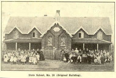
... ...parwan...Contents include Bacchus Marsh and its soldiers, Red Cross, Lerderderg Gorge, Werribee Gorge, Lerderderg Park, Coimadai, Darely Firebrick Co., Myrniong, Underbank, Balliang, Rowsley, Parwan, schoosl, churches, Shire Council, Federal Milk Pty Ltd, Bacchus Marsh Milk, Old Maddingley Bridge Images include: * Bacchus Marsh looking east, 1930 * Bacchus Marsh Looking West, 1872 * Bacchus Marsh Looking West, 1930 * Aerial View of Bacchus Marsh Township looking east * Aerial View of Bacchus Marsh Township looking south * Bacchus Marsh Agricultural Society & Pastoral Society, 1893 (named), * Original Bacchus Marsh State School No 28 * Holy Trinity Bacchus Marsh * Bacchus Marsh Baptist Church * St Bernard's Catholic Church * Bacchus Marsh Methodist Church * St Andrew's Presbyterian Church Bacchus Marsh * View of Maddingley Park, showing Original Courthouse, 1890 * Werribee Gorge * Underbank Stud Farm * Ballarat State School Number 28. ...(Back to Bacchus Marsh, 1930) bacchus marsh maddingley maddingley park underbank lerderderg park coimadai darely firebrick co. myrniong balliang rowsley parwan schoosl churches shire council federal milk pty ltd bacchus marsh milk old maddingley bridge police police paddock maddingley gates crisp mccormack cain harkness howe bence mcdonald mcfarlane cosgrave flagg burnip scott lodge cameron vallance bacchus marsh state school bacchus marsh state school no 28. geology r.w. thompson lederderg gorge weribee gorge comadai darley firebrick company Signed 'C. ...The 1930 Back to Bacchus Marsh celebrations were held on 23 to 28 October 1930. The committee were Cr L.M. Gugdale (president), A.W. Bond (General secretary), W. Grant Morton, J.G. Wells, Dr E. McDonald, Charles Dickie, G.H. Anderson, F.M. Crisp, W.R. Vigor. Bacchus Marsh State School No. 28 was established in 1851 as a National School in a rented building on the right-hand side of Bacchus Marsh-Melbourne Road, just beyond Woolpack Inn. Several willow trees mark the site. H.G. Ball was the first Head Teacher of the school, and the enrolmen towas 34. In 1854 Governor Charles Hotham visited the school. In 1855 two new schools, East and West, were recommended. School No. 28 closed in 1862 and the sitre was sold. The present school site was purchased in 1865 for 67 pounds. The cost of the building was 782 pounds. (Visions and Realisations, Vol 3., 1973) A clock purchased by public subscription was placed in the front of the building to the memory of scholars who served during World War One. (Back to Bacchus Marsh, 1930)Brown covered book of 44 pages. Contents include Bacchus Marsh and its soldiers, Red Cross, Lerderderg Gorge, Werribee Gorge, Lerderderg Park, Coimadai, Darely Firebrick Co., Myrniong, Underbank, Balliang, Rowsley, Parwan, schoosl, churches, Shire Council, Federal Milk Pty Ltd, Bacchus Marsh Milk, Old Maddingley Bridge Images include: * Bacchus Marsh looking east, 1930 * Bacchus Marsh Looking West, 1872 * Bacchus Marsh Looking West, 1930 * Aerial View of Bacchus Marsh Township looking east * Aerial View of Bacchus Marsh Township looking south * Bacchus Marsh Agricultural Society & Pastoral Society, 1893 (named), * Original Bacchus Marsh State School No 28 * Holy Trinity Bacchus Marsh * Bacchus Marsh Baptist Church * St Bernard's Catholic Church * Bacchus Marsh Methodist Church * St Andrew's Presbyterian Church Bacchus Marsh * View of Maddingley Park, showing Original Courthouse, 1890 * Werribee Gorge * Underbank Stud Farm * Ballarat State School Number 28. Signed 'C. Hodgson'bacchus marsh, maddingley, maddingley park, underbank, lerderderg park, coimadai, darely firebrick co., myrniong, balliang, rowsley, parwan, schoosl, churches, shire council, federal milk pty ltd, bacchus marsh milk, old maddingley bridge, police, police paddock, maddingley gates, crisp, mccormack, cain, harkness, howe, bence, mcdonald, mcfarlane, cosgrave, flagg, burnip, scott, lodge, cameron, vallance, bacchus marsh state school, bacchus marsh state school no 28., geology, r.w. thompson, lederderg gorge, weribee gorge, comadai, darley firebrick company -
 Melton City Libraries
Document, 'Schutt and Barrie Flour Mill envelope, Unknown
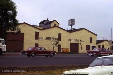
... The firm purchased a mill at Parwan and Dad spent a lot of time and energy getting it running to their satisfaction. ...The firm purchased a mill at Parwan and Dad spent a lot of time and energy getting it running to their satisfaction. ...SUMMARY - Schutt & Barrie Chaff Mills Partnership West Footscray, Parwan and Diggers Rest. Mary nee Barrie Robinson (1907 –1999) writes c1980 about her father Charles Ernest Barrie of Darlingsford Melton (1871 – 1931) Extract copied from her handwritten story - My father was born in Ballarat in 1871. … commenced his working life with a team of bullocks and a chaffcutter in the St Arnaud district, a work the he became most success at and would continue in to the end of his life. He eventually became the owner of a chaff mill at Melton station with an access line to the railway. [1900] The Schutt & Barrie partnership ….Dad later became involved in a Chaff mill at West Footscray run by John Ralph Schutt who when he met Dad was a very sick man and had begged Dad to come into the business and help him. That began a very happy association, the business was put on its feet. An empty quarry across Geelong Road opposite the mill was purchased, the chaffcutters were set up in the quarry and that was the start of a very busy and prosperous period. A branch line was run into the mill. Dad spent some afternoons at the mill going by train, and spending some hours there at night, at the same time running the farm with full time help. Two full 8 horse teams were used to work the land, which meant early rising for the horses to be fed and harnessed ready for the men to commence the days work. Charlie Lowe and Murdock Davey were two of the men who worked for Dad in those years. The firm purchased a mill at Parwan and Dad spent a lot of time and energy getting it running to their satisfaction. Monday was the day he spent time there also round the district of Parwan and Balliang. He came to know many of the their names were well known in our household for many years. [1920] Later a flour mill was built beside the Chaff mill at West Footscray but it never thrived like the mill. The chaff mill had many loyal and good men employed there and there was never any trouble between men and management. Willie Walters and Miss Renyolds were some I remember, other names me, Joyce would be able to name them. [Sister of Mary born 1920] Sample envelope from the businesslocal identities -
 Bacchus Marsh & District Historical Society
Photograph, Glenmore Homestead 1883
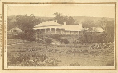
... Charles Griffith, an Irish barrister, with his friend, James Moore, settled on Glenmore Station in the Parwan Valley in 1840. Their partnership lasted until 1848. ...Charles Griffith, an Irish barrister, with his friend, James Moore, settled on Glenmore Station in the Parwan Valley in 1840. Their partnership lasted until 1848. ...This homestead was built by Charles Griffith on a 55,000 acre Run. It replaced an earlier dwelling which was a slab hut with a bark roof. Charles Griffith, an Irish barrister, with his friend, James Moore, settled on Glenmore Station in the Parwan Valley in 1840. Their partnership lasted until 1848. In 1846, whilst in Ireland, Griffith married Miss Jane Catherine Magee, then returned to Glenmore and later took his nephew, Molesworth Richard Greene, into partnership, which arrangement proved to be long and prosperous. In 1857, they bought runs at Mount Hope and Mount Pyramid, which they kept until the days of free selection. Griffith led an active and successful public life.He was a member of the new Victorian Legislative Council in 1851, and was later an elected representative of the Legislative Assembly 1853-1859. He occupied many important public positions, including that of magistrate for Bacchus Marsh. Griffith was a devout Anglican and hosted Bishop Charles Perry at his station near Bacchus Marsh in 1849. He died in 1863 at his home in South Yarra.Small sepia unframed photograph on card with gold border framing photograph. Housed in the album, 'Photographs of Bacchus Marsh and District in 1883 by Stevenson and McNicoll'. The photograph shows a view of an extensive single-storey homestead consisting of three adjoining buildings, with a further building on the left of the main property. The series of three buildings is built in an elevated position, with pathways leading through a garden. At the front there is a vegetable garden which seems to be still in a state of development. The main house, possibly of brick, is set at an angle to the other two in this complex. It has a hip roof with a concave verandah on two sides with arched barge boards and simple unadorned pillars. There appears to be a hammock slung between two pillars. Two chimneys can be seen on this dwelling.The adjoining building is of a simpler design, with a lower roof line and a verandah running along the front. Two chimneys can be seen, one emitting smoke. This middle building may be a kitchen and rooms for day-to-day use. The third building is also of a simpler design, with a gable above a verandah. The purpose of this building is less clear. The different styles of construction suggest that these buildings were built separately at different times for different purposes. To the left of the main group of buildings is another cottage, smaller and of a simpler design. A fence runs along the front, clearly separating this building from the others, suggesting it may have been the dwelling of an overseer.On the front: Stevenson & McNicoll. Photo. 108 Elizabeth St. Melbourne. COPIES CAN BE OBTAINED AT ANY TIME. On the back: LIGHT & TRUTH inscribed on a banner surmounted by a representation of the rising sun. Copies of this Portrait can be had at any time by sending the Name and Post Office Money Order or Stamps for the amount of order to STEVENSON & McNICOLL LATE BENSON & STEVENSON, Photographers. 108 Elizabeth Street, MELBOURNE. stevenson and mcnicoll 1883 photographs of bacchus marsh and district, farms bacchus marsh, charles james griffith 1808-1863, glenmore station -
 Melton City Libraries
Photograph, Schutt and Barrie Pty Ltd Chaff Cutting Mills, Unknown
... The firm purchased a mill at Parwan and Dad spent a lot of time and energy getting it running to their satisfaction. ...The firm purchased a mill at Parwan and Dad spent a lot of time and energy getting it running to their satisfaction. ...Mary nee Barrie Robinson (1907 –1999) writes c1980 about her father Charles Ernest Barrie of Darlingsford Melton (1871 – 1931) Extract copied from her handwritten story - My father was born in Ballarat in 1871. … commenced his working life with a team of bullocks and a chaffcutter in the St Arnaud district, a work the he became most success at and would continue in to the end of his life. He eventually became the owner of a chaff mill at Melton station with an access line to the railway. [1900] The Schutt & Barrie partnership Dad later became involved in a Chaff mill at West Footscray run by John Ralph Schutt who when he met Dad was a very sick man and had begged Dad to come into the business and help him. That began a very happy association, the business was put on its feet. An empty quarry across Geelong Road opposite the mill was purchased, the chaffcutters were set up in the quarry and that was the start of a very busy and prosperous period. A branch line was run into the mill. Dad spent some afternoons at the mill going by train, and spending some hours there at night, at the same time running the farm with full time help. Two full 8 horse teams were used to work the land, which meant early rising for the horses to be fed and harnessed ready for the men to commence the days work. Charlie Lowe and Murdock Davey were two of the men who worked for Dad in those years. The firm purchased a mill at Parwan and Dad spent a lot of time and energy getting it running to their satisfaction. Monday was the day he spent time there also round the district of Parwan and Balliang. He came to know many of the their names were well known in our household for many years. [1920] Later a flour mill was built beside the Chaff mill at West Footscray but it never thrived like the mill. The chaff mill had many loyal and good men employed there and there was never any trouble between men and management. Willie Walters and Miss Renyolds were some I remember, other names me, Joyce would be able to name them. [Sister of Mary born 1920] Schutt and Barrie Pty Ltd Chaff Cutting Mills Melton South sitelocal architecture, local identities, agriculture -
 Sunshine and District Historical Society Incorporated
Document - Naming of Sunshine Railway Station, Rigg, Tom (re.notes), Various
... The Melbourne to Bendigo railway was built in 1859 and the railway to Ballarat began first to Melton in 1884 to Parwan in 1886 and to Bacchus Marsh in 1887. ...The Melbourne to Bendigo railway was built in 1859 and the railway to Ballarat began first to Melton in 1884 to Parwan in 1886 and to Bacchus Marsh in 1887. ...Collected by Tom RiggUntil about 1884 the general area now occupied by Sunshine / Braybrook was known as CUT PAW PAW. The Melbourne to Bendigo railway was built in 1859 and the railway to Ballarat began first to Melton in 1884 to Parwan in 1886 and to Bacchus Marsh in 1887. The junction of the two lines was known as Bacchus Marsh Junction during construction and after completion the area became Braybrook Junction no doubt influenced by the nearby settlement of Braybrook. In 1907 the Braybrook Junction Progress Association petitioned the Victorian Railways Commissioners requesting that the station name be changed to Sunshine Junction possibly recognising the dominating presence of the Sunshine Harvester Works. Approval was very promptly granted by the Commissioners and in the Victoria Gazette of July 17 1907 page 3419 the Victorian Railways gazetted that on and after Monday 15th July the name of Braybrook Junction station will be changed to Sunshine.sunshine railway station, railway