Showing 22 items matching "pastoral runs"
-
 Eltham District Historical Society Inc
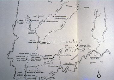
Slide - Photograph, Pastoral Runs, Diamond Creek Catchment, c.Sep. 1989
... Pastoral Runs, Diamond Creek Catchment......Pastoral Runs...Diamond Creek Catchment Map Pastoral Runs Process Date Sep 1989 35mm colour positive transparency (1 of 33) Mount - Agfa CS System grey 8 dots Pastoral Runs, Diamond Creek Catchment Slide Photograph ...Part of a slide show presentation "Bridges & Waterways of the Shire" by Russell Yeoman to the 13 September 1989 Society meeting. The presentation included slides of historic photos from the Shire of Eltham Pioneers collections as well as several recent views.35mm colour positive transparency (1 of 33) Mount - Agfa CS System grey 8 dotsProcess Date Sep 1989diamond creek catchment, map, pastoral runs -
 Kiewa Valley Historical Society
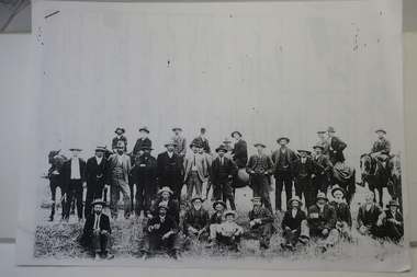
Papers photocopied - photo, list of names, Kiewa Valley Pioneers and Early Activities on the Bogong High Plains
... Tawonga and Mullindollongong pastoral runs...Waters Tawonga and Mullindollongong pastoral runs 1.The photo includes a listing of residents selecting a site for a bridge at Keegans Crossing. 2. ...All Early History of the Kiewa Valley. 1. Photo clear but no date. Men named and are residents selecting a site for a bridge at Keegans Crossing 2. Department of Crown Lands letter - 1841 Tawonga pastoral run - Mr James Roberts and Mullindollingong pastoral run 1846 - Mr Patrick Reynolds 3. An account of the Bogong High Plains by W. F. Waters from the late 1890s to 1930s. Published article in the Schuss magazine. August 1958 History of Keegan's Crossing, Kiewa Valley and surrounding residents with names and photos. Early pastoral runs in the Kiewa Valley and Early activities on the Bogong High Plalns..1.The photo includes a listing of residents selecting a site for a bridge at Keegans Crossing. 2. A letter from the Department of Victorian Lands and Survey re early settlers 3. History written in Schuss magaine, Aug. 1958. "In 1896 ... erection of snow poles from Rocky Valley to Tawonga Hut. keegan's crossing, w.f. waters, tawonga and mullindollongong pastoral runs -
 Bendigo Historical Society Inc.
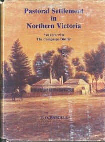
Book - PASTORAL SETTLEMENT IN NORTHERN VICTORIA - VOL 1. THE COLIBAN DISTRICT, 1979
... ... pastoral settlement... stations... runs...History House 11 Mackenzie Street Bendigo goldfields HISTORY Agriculture northern victoria - coliban farming agriculture pastoral settlement stations runs J.O. Randell Pastoral Settlement in Northern Victoria, volume 1, the Coliban District. 353 pages with illustrations, photographs and maps. ...Pastoral Settlement in Northern Victoria, volume 1, the Coliban District. 353 pages with illustrations, photographs and maps.J.O. Randellhistory, agriculture, northern victoria - coliban, farming, agriculture, pastoral settlement, stations, runs -
 Kiewa Valley Historical Society
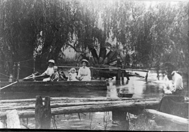
Photo - Water Wheel and Punt on the Kiewa River - Tangambalanga Homestead
... In early times, Homesteads were part of pastoral runs many of which had frontage onto a river....Kiewa Valley Historical Society Mount Beauty Information Centre 31 Bogong High Plains Rd Mt Beauty high-country In early times, Homesteads were part of pastoral runs many of which had frontage onto a river. ...In early times, Homesteads were part of pastoral runs many of which had frontage onto a river.Tangambalanga Homestead, on the Kiewa River, was subdivided in 1862 from T. Mitchell to Thomas BrownBlack and white shiny photo with women and children in a boat on 'flood' waters and a woman on the bank near a footbridge or jetty. The ladies are wearing hats, long skirts and blouses. In the background there is a large water wheel and trees. This photo is published on Page 19 of 'A History of the Kiewa Valley' by Esther Temple and David Lloyd.tangambalanga homestead, water wheel on the kiewa river, punt on the kiewa river -
 Melton City Libraries
Photograph, "Green Hills" Borbidge, 1978
... Built by Water Browne c.1903 Greenhills was one of the first pastoral runs, and centres of European settlement, established in the Shire of Melton. ...Melton City Libraries 31 McKenzie Street Melton melbourne Built by Water Browne c.1903 Greenhills was one of the first pastoral runs, and centres of European settlement, established in the Shire of Melton. ...Built by Water Browne c.1903 Greenhills was one of the first pastoral runs, and centres of European settlement, established in the Shire of Melton. Estate in Diggers Rest Coimadai Road, Toolern Valelocal architecture, pioneer families -
 Federation University Historical Collection
Book, Dr Ian D. Clark et al, Pyrenees Shire, University of Ballarat, Tourism Planning and Development
... The Themes that have been most prevalent in the Shire are: Major Mitchell's Impact Pastoral Runs in the Pyrenees Shire Aboriginal History Gold Rush Era Chinese History Wine Production...Barker Library (top floor) Mount Helen goldfields The Themes that have been most prevalent in the Shire are: Major Mitchell's Impact Pastoral Runs in the Pyrenees Shire Aboriginal History Gold Rush Era Chinese History Wine Production nature based tourism accommodation restaurants transport attractions funding community interest production development plan trevor peek geoffrey gray djadja wurrung aboriginal clan the australian tourism commission tourism victoria avoca beaufort snake valley amphitheatre landsborough lexton elmhurst moonambel mt cole redbank mount lonarch lake goldsmith st arnaud lamplough buangor natte yallock navarre/barkly percydale Pink soft covered book of 35 pages with fifteen appendices. ...The Themes that have been most prevalent in the Shire are: Major Mitchell's Impact Pastoral Runs in the Pyrenees Shire Aboriginal History Gold Rush Era Chinese History Wine ProductionPink soft covered book of 35 pages with fifteen appendices. It includes pull out maps and plans. nature based tourism, accommodation, restaurants, transport, attractions, funding, community interest, production development plan, trevor peek, geoffrey gray, djadja wurrung aboriginal clan, the australian tourism commission, tourism victoria, avoca, beaufort, snake valley, amphitheatre, landsborough, lexton, elmhurst, moonambel, mt cole, redbank, mount lonarch, lake goldsmith, st arnaud, lamplough, buangor, natte yallock, navarre/barkly, percydale -
 Greensborough Historical Society
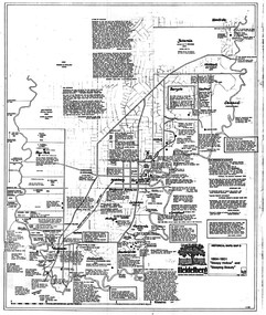
Map, Heidelberg: Historic River Landscape Assessment. Historical maps. Map D 1864 -1901 "Sleepy Hollow" and "Sleeping beauty", 1985c
... Geographical area of c. 35 sq. kilometres marked with physical features such as major roads, rivers, vegetation and properties, with locations and notes on the increasing number of farms, orchards and vineyards that had been developed in addition to pastoral runs. Bounded by Shire of Diamond Valley to the North, Darebin Creek to the West, and Plenty River to the East....Greensborough Historical Society 34A Glenauburn Road Lower Plenty Lower Plenty melbourne Geographical area of c. 35 sq. kilometres marked with physical features such as major roads, rivers, vegetation and properties, with locations and notes on the increasing number of farms, orchards and vineyards that had been developed in addition to pastoral runs. Bounded by Shire of Diamond Valley to the North, Darebin Creek to the West, and Plenty River to the East. heidelberg heidelberg - maps Black and white sketch on white paper. ...Geographical area of c. 35 sq. kilometres marked with physical features such as major roads, rivers, vegetation and properties, with locations and notes on the increasing number of farms, orchards and vineyards that had been developed in addition to pastoral runs. Bounded by Shire of Diamond Valley to the North, Darebin Creek to the West, and Plenty River to the East.Black and white sketch on white paper. Second copy 600 x 430 cm printed in black on semi-opaque paperheidelberg, heidelberg - maps -
 Greensborough Historical Society
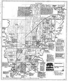
Map, Heidelberg. Historic River Landscape Assessment. Historical maps: Map C 1851-1863. "The Garden of the colony", 1985c
... Geographical area of around 35 sq. kilometres marked with physical features such as major roads, vegetation and properties, with locations and notes of the increasing number of farms, gardens orchards and vineyards which had become established in addition to pastoral runs. Bounded by Shire of Diamond Valley to the North, Darebin Creek to the West and Plenty River to the East....Greensborough Historical Society 34A Glenauburn Road Lower Plenty Lower Plenty melbourne Geographical area of around 35 sq. kilometres marked with physical features such as major roads, vegetation and properties, with locations and notes of the increasing number of farms, gardens orchards and vineyards which had become established in addition to pastoral runs. Bounded by Shire of Diamond Valley to the North, Darebin Creek to the West and Plenty River to the East. heidelberg heidelberg - maps Black and white sketch map on white paper Heidelberg. ...Geographical area of around 35 sq. kilometres marked with physical features such as major roads, vegetation and properties, with locations and notes of the increasing number of farms, gardens orchards and vineyards which had become established in addition to pastoral runs. Bounded by Shire of Diamond Valley to the North, Darebin Creek to the West and Plenty River to the East.Black and white sketch map on white paperheidelberg, heidelberg - maps -
 Ballarat Heritage Services
Image, Stawell, c1918, c1918
... Pastoral runs in the Stawell area were selected in the 1840s, but it was the gold found by a shepherd in the district in May 1853 that provided the real reason for the foundation of a township. ...Ballarat Heritage Services PO Box 2209 Bakery Hill Post Office goldfields Pastoral runs in the Stawell area were selected in the 1840s, but it was the gold found by a shepherd in the district in May 1853 that provided the real reason for the foundation of a township. ...Pastoral runs in the Stawell area were selected in the 1840s, but it was the gold found by a shepherd in the district in May 1853 that provided the real reason for the foundation of a township. By August 1854, 5,000 people were seeking their fortune at the Pleasant Creek goldfield. By 1857 the fabulously rich deep alluvial leads to Commercial Street and Deep Lead had been discovered and rushes of eager gold seekers brought 20,000 people to the fields.Black and white photograph of the central Victorian town of Stawell (formerly known as Pleasant Creek). .stawell, pleasant creek -
 Wodonga & District Historical Society Inc
Tool - Shearing Hand Set
... Many of the early settlers to North East Victoria droved sheep overland from both Sydney and South Australia and established large pastoral runs in the district. Wodonga became a major service centre for the industry and established major saleyards for the pastoral and cattle industries. ...Many of the early settlers to North East Victoria droved sheep overland from both Sydney and South Australia and established large pastoral runs in the district. Wodonga became a major service centre for the industry and established major saleyards for the pastoral and cattle industries. ...The wool industry has been critical to the Australian economy from the early days of European settlement. The increase in wool production in the mid to late 19th century led to the need to replace the hand shears with some mechanized forms of shearing.The first commercially successful sheep shearing machinery by Frederick York Wolseley in New South Wales who was granted a patent for his machine on 28 March 1877. Many of the early settlers to North East Victoria droved sheep overland from both Sydney and South Australia and established large pastoral runs in the district. Wodonga became a major service centre for the industry and established major saleyards for the pastoral and cattle industries. The handset has the company name "Heiniger" on the side. Heiniger is a Swiss company with subsidiaries in Australia and New Zealand. It was originally established in 1946.This item is connected to a major rural industry in North East Victoria.A metal handpiece for a sheep shearing. A toothed blade is held in place with metal adjustable screws at one end. A jointed metal pipe at the other end allows attachment to the shearing machine. The hinge has been covered with leather.On adjustment knob "Heinger"shearing industry, shearing equipment, shearing handset -
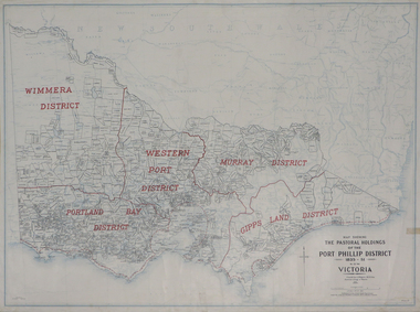 Federation University Historical Collection
Plan, Map Showing the Pastoral Holdings of the Port Phillip District 1835-1851 Now Victoria, 1932, 1932
... Another name for Pastoral Holdings is squatting runs. Information on Alfred Stephen Kenyon of the Historical Society of Victoria can be found at http://adb.anu.edu.au/biography/kenyon-alfred-stephen-6936/text12035 ...Barker Library (top floor) Mount Helen goldfields Another name for Pastoral Holdings is squatting runs. Information on Alfred Stephen Kenyon of the Historical Society of Victoria can be found at http://adb.anu.edu.au/biography/kenyon-alfred-stephen-6936/text12035 pastoral holdings squatters squatting victoria land crown lands a.s. kenyon alfred stephen kenyon Map of Victoria showing the boundaries of the Port Phillip District (Victoria) pastoral boundaries. ...Another name for Pastoral Holdings is squatting runs. Information on Alfred Stephen Kenyon of the Historical Society of Victoria can be found at http://adb.anu.edu.au/biography/kenyon-alfred-stephen-6936/text12035 Map of Victoria showing the boundaries of the Port Phillip District (Victoria) pastoral boundaries. pastoral holdings, squatters, squatting, victoria, land, crown lands, a.s. kenyon, alfred stephen kenyon -
 Flagstaff Hill Maritime Museum and Village
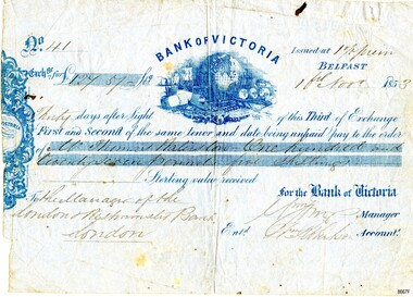
Currency - Banknote Belfast, Bank of Victoria, 1853
... This was a colonial bank at the time of vast pastoral runs and gold speculation – how "Mr Thomas [....ton?]" ...This was a colonial bank at the time of vast pastoral runs and gold speculation – how "Mr Thomas [....ton?]" ...The promissory note issued at Belfast, now Port Fairy, Victoria by the “Bank of Victoria” is an early example of currency issued by a private bank. This note was issued in 1853 the same year that the bank commenced business in Belfast. Details of the first production of a banknote backed by the Australian Government occurred on 1 May 1913 following the "Australian Notes Act of 1910" (Australian National Museum). The first building the Bank of Victoria purchased in Belfast was of timber and later sold. Smith & Watts Architects advertised for tenders in the Melbourne Argus on Thursday 29/4/1869 for the erection of a substantial building that is now occupied by Moyne Shire Council in Cox Street. A meeting of the Directors of the Bank of Victoria elected on 1 October 1852. A ballot took place for four directors resulting in Wm. Highett Esq. Wm F. Splatt, Esq. M.L.C., Alex. Wilson, Esq. and W.H. Tuckett” elected as Directors. It was reported from a later meeting in “The Argus” Melbourne on 3 August 1853 that a branch had opened in Swanston Street, Melbourne on 3rd January 1852 with Henry Miller as Chairman of the Board and J. Matheson as the Manager; followed by Geelong on 12 August 1852. Then at the request of “influential inhabitants”, the Belfast branch commenced on 11 May 1853, which had “already met with very general support and encouragement”. This was a colonial bank at the time of vast pastoral runs and gold speculation – how "Mr Thomas [....ton?]" came by his fortune of One Hundred and Twenty-Seven Pound and five shillings can only be wondered at until further research reveals the story. This promissory note records the early colonial system of banking and reflects the economic growth and entrepreneurship of the South West Region of Victoria.Banknote of fine paper. There is a fold multi-crease down the centre top to bottom, lighter creasing across the top and angular creasing to the bottom left and right-hand corners. Yellow spotting is visible across the object breaking through the grey blue colour of the paper. A dark ink blot appears near the top right-hand corner. The left-hand side of the banknote is uneven. The back of the document has darker spotting, a used dirty look patina and some insect spotting. Horizontal crease markings can be seen creating quarter marks. The front of the banknote reads: "No.41/ Exch.ge for £127.57- Bank of Victoria/Issued at 1% prem/Thirty days after Sight of this Third of Exchange/First and Second of the same tenor and date being unpaid pay to the order of/Mr. Thomas [Raliston?]/One hundred and twenty seven pounds five shillings Sterling silver received/To the Manager of the London Westminister Bank London/for the Bank of Victoria [signed?] Manager/Ent.d [?] Robertson Account.t. The blue printed Bank of Victoria logo features a world globe, sailing ships, wool bails, sheep, colonial building and mining tools. flagstaff hill, warrnambool, maritime village, maritime museum, flagstaff hill maritime museum and village, shipwreck coast, great ocean road, promissory notes, bank notes, bank of victoria, smith & watts, smith & watts architects, 1853, william highett, william f. splatt, alex wilson, w.h. tuckett, henry miller, money miller, belfast (now port fairy), banknote -
 Flagstaff Hill Maritime Museum and Village
Book - Atlas, F.E. Hiscocks and Co, New Victorian Counties Atlas, 1874
... According to its original title page, the atlas maps out townships, pastoral runs, road boards, shires, and stations—explicitly naming the land occupiers, the exact acreage of their holdings, and the grazing capacity of the land. ...According to its original title page, the atlas maps out townships, pastoral runs, road boards, shires, and stations—explicitly naming the land occupiers, the exact acreage of their holdings, and the grazing capacity of the land. ...Published in Melbourne in 1874 by the prominent bookseller and publisher George Robertson, F.E. Hiscocks & Co.’s New Victorian Counties Atlas is a monumental 19th-century cartographic and statistical record of the colony of Victoria. While George Robertson was the publisher responsible for production, marketing, and distribution, the detailed compiling and surveying were executed by F.E. Hiscocks & Co., with the striking colour lithography handled by the renowned Melbourne firm Hamel & Ferguson.Hard cover book, New Victorian Counties Atlas Author: F.E. Hiscocks and Co, Publisher: George Robertson, Melbourne Vic. Date: 1874 Morocco Olive hardcover with a damaged black spine, reinforced corners to hardcover gold edging to where spine meets hardcover. Title in a lozenge on front cover edged with a decorative panel. non-fictionPublished in Melbourne in 1874 by the prominent bookseller and publisher George Robertson, F.E. Hiscocks & Co.’s New Victorian Counties Atlas is a monumental 19th-century cartographic and statistical record of the colony of Victoria. While George Robertson was the publisher responsible for production, marketing, and distribution, the detailed compiling and surveying were executed by F.E. Hiscocks & Co., with the striking colour lithography handled by the renowned Melbourne firm Hamel & Ferguson.flagstaff hill, warrnambool, maritime village, maritime museum, shipwreck coast, great ocean road, new victorian counties atlas, hiscocks and co, atlas, maps -
 Bendigo Historical Society Inc.
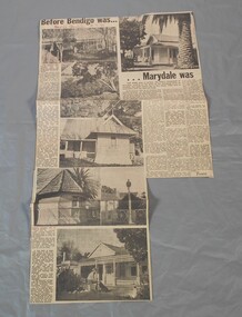
Newspaper - Lydia Chancellor collection: Article-Before Bendigo was....Marydale was
... "Marydale", at 2270 McIvor Hwy., Axedale, was part of the original Campaspe Plains and Axe pastoral runs. By 1857 William Heffernan(1803-1891) had purchased the property from the "Axedale Station's" Robert Ross. it's heritage listing includes the outbuildings that remain in their original format and include the summerhouse and the schoolroom. ...History House 11 Mackenzie Street Bendigo goldfields "Marydale", at 2270 McIvor Hwy., Axedale, was part of the original Campaspe Plains and Axe pastoral runs. By 1857 William Heffernan(1803-1891) had purchased the property from the "Axedale Station's" Robert Ross. it's heritage listing includes the outbuildings that remain in their original format and include the summerhouse and the schoolroom. ..."Marydale", at 2270 McIvor Hwy., Axedale, was part of the original Campaspe Plains and Axe pastoral runs. By 1857 William Heffernan(1803-1891) had purchased the property from the "Axedale Station's" Robert Ross. it's heritage listing includes the outbuildings that remain in their original format and include the summerhouse and the schoolroom. Also included in the listing are the extensive gardens of mature trees. 1. William Heffernan (1803-1891) was born in Tipparary, Ireland and came to Australia in 1853 with Mr J Crowley. Together they first went to the Heathcote goldfields before moving on to Bendigo where they initially opened a tent restaurant. This successful endeavour allowed them to purchase the Pall Mall site of the Shamrock hotel. They built their first hotel and a large hall for entertainment that was later called the Theatre Royal. They continued to grow and expand until they built the current Shamrock building. He went on to several other successful theatres and hotels before retiring to "Marydale" in 1879/80. Before moving to New Zealand in 1884/5 he sold "Marydale" to Jeremiah Heffernan. He went to NZ to manage a hotel for his newly widowed sister and then built the Pier Hotel in Dunedin. By the time of his death in Dunedin he had lost most of his fortune. 2. Jeramiah Heffernan (1831-1897) was also born in Tipparary, Ireland but was no relation to William. He came to Australia in 1854 and to Bendigo in 1855, where he was employed by William and his partner, Mr Crowley at the Shamrock Hotel in Pall Mall. Twelve months later he became the manager of Heffernan and Crowley's Rose Shamrock and Thistle Hotel at Epsom. After twelve months in this position he bought the Albert Hotel in McCrae Street, Bendigo. He was a successful businessman who later purchased the Victoria Hotel in Pall Mall before retiring in 1887,firstly to "Marydale" that he had bought from William Heffernan in the early 1880's and then to his home in St Kilda. On doctors orders he returned to "Marydale" where he died 13/5/1897.Bendigo Advertiser from 18/07/1970. Article titled "Before Bendigo was....Marydale was." by Toora. The article describes the historic homestead of Marydale at Axedale.In red pen "Bendigo Advertiser 18-7-70"marydale, axedale, historic homestead -
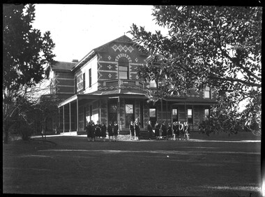 City of Melbourne Libraries
Photograph, Bull, Hugh Jones, 1897-1993, Ruyton Girls School 1933
... Purchas produced one of the few published maps and compilations of the early pastoral settlers runs in Victoria in 1853. In the same year he designed the layout of the Melbourne General Cemetery, the first 'garden' cemetery in Victoria, a curvilinear layout with extensive plantings, as well as the gate lodge and gates (the gates lodge were demolished and the gates relocated to their present position in the 1930s). ...Purchas produced one of the few published maps and compilations of the early pastoral settlers runs in Victoria in 1853. In the same year he designed the layout of the Melbourne General Cemetery, the first 'garden' cemetery in Victoria, a curvilinear layout with extensive plantings, as well as the gate lodge and gates (the gates lodge were demolished and the gates relocated to their present position in the 1930s). ...Published: Age (Melbourne, Vic.: 1854- ), 4 August 1933, page 3 Published title: GIRLS’ SCHOOLS – MODEL YACHTING - FOOTBALL Published caption: The headmistress, Miss H. Daniell, and girls at Ruyton, Selbourne Road, Kew, snapped after school hours. Trove article identifier: http://nla.gov.au/nla.news-article204381763 Research by Project Volunteer, Louise McKenzie: Rather than the people, this charming building takes the eye! Originally named “Tarring”, it was built in 1872 by Mr Henry Henty and his wife Mrs Marion Anne Henty (nee McKellar) for their family. Located at 82 Selbourne Road, Kew, it is described by Melbourne’s Open House organisation as “… a two-storey, polychrome brick mansion built for them by prominent Melbourne architect Albert Purchas. The house and nearly four acres of grounds served as their family home until the death of Marian Henty in 1919. “ (See below for further information on Albert Purchas.) In 1920 it was sold to Ruyton Girls School. Ruyton was established in 1878 by its first principal, Charlotte Anderson (1838-1906), who named it in honour of the parish in Shropshire, England, Ruyton-XI-Towns, where her great-great-grandfather David Evans had been vicar. Its motto is Recte et Fideliter, meaning "Upright and Faithful", which is also the name of the school song. The original school, one of Victoria’s oldest independent schools for girls, was located at the home of Mrs Anderson at 63 High Street South, Kew. In 1882 she moved the school to Edgecombe in Studley Park Road. Mrs Anderson retired due to ill health and sold the school to her friend Miss Eliza Bromby. One of Ruyton's four Houses, Anderson, is named for Charlotte Anderson. When Ruyton Girls School was moved to the site in 1920 it established the building as a Boarding House, and renamed the building “Henty House” in honour of its original owners. Today the school remains an all girls’ school, and pays tribute to its founder and the historic significance of Henty House and its magnificent Moreton Bay Fig tree, which still stands today. The building retains many original, Victorian-era features, while also showing the layers of change, made over the decades in order to meet the evolving needs of one of Melbourne’s leading schools. The headmistress mentioned in the caption for MCK016 is Miss Hilda Daniell, shown standing in front of Henty House in the midst of a group of Ruyton girls in their school uniforms, some holding hockey sticks. Miss Daniell was the longest serving Principal of Ruyton 1913-1952. She was originally a student in 1893, then joined the teaching staff in 1898. It was under her leadership that the School purchased and moved to “Tarring”. The boarding house included a flat for Hilda to live onsite. An article in the Ruyton Heritage Collection – Bedford Series, dated 21 May 2021 cites that Miss Daniell “was affectionately known as “Dream” by Ruytonians of her era” apparently due to a tendency to quiet reflection. The article continues, “After her retirement in 1952 Miss Daniell was awarded an Order of the British Empire for her many services to education, an award she received from the hands of the Queen during the 1954 Royal Tour. Also in 1952, the Kew Council honoured her by renaming Brougham Place as ‘Daniell Place’.” Arthur Purchas, architect: The architect responsible for the design of “Tarring”. Arthur Purchas, was extremely active and highly regarded at this time. Born in Wales in 1825, he emigrated to Melbourne in 1851 and soon established a private practice as a surveyor and architect, with offices variously in Little Collins, Queen Street, Chancery Lane, and finally 462 Little Collins Street. Wikipedia notes in an early reference to Purchas that “An early story is that one of his first jobs, when he would have been about 25 years old, was a position under Surveyor-General Robert Hoddle, and disagreeing with him over the line for St Kilda Road, appealed to Governor La Trobe, and successfully got the road diverted around the hill which eventually became the site of the Shrine of Remembrance. There may not be much truth to this, since by 1851 St Kilda Road was already a well worn track running around the hill, the top of which La Trobe had reserved for a Government House in 1840.” The timing of Purchas’s arrival in Melbourne was perfect. The Victorian gold rush of the 1850’s generated enormous wealth in Melbourne, and a building boom followed. The Wikipedia entry continues … that alone, or with his brother in law Charles R Swyer, “Purchas is said to have designed over 140 houses, offices, churches, banks and cemetery buildings in Victoria in his long career. Berkely Hall, St Kilda dating from 1854 is one of his first buildings, and still exists, though the original house is obscured by an early C20th verandah. Another notable early design was the head office of the Melbourne Savings Bank, built on the corner Flinders Lane and Market Street in 1857-58, in an elaborately detailed Renaissance Revival style. His churches were mostly Gothic Revival, built for the Anglican Church, along with some parsonages, while most of the bank buildings were Renaissance Revival designs for the Bank of Australasia. He also designed city buildings in the 1860s and 70s, such as the Mutual Insurance Co, Northern Insurance Co, and the first premises for George & George, destroyed by fire in 1889. One of his most outstanding designs is St George's Presbyterian Church in Chapel Street, St Kilda (1877–80), in a striking polychrome brick Gothic Revival style, unusually carried on through to the interior. Purchas produced one of the few published maps and compilations of the early pastoral settlers runs in Victoria in 1853. In the same year he designed the layout of the Melbourne General Cemetery, the first 'garden' cemetery in Victoria, a curvilinear layout with extensive plantings, as well as the gate lodge and gates (the gates lodge were demolished and the gates relocated to their present position in the 1930s). He was a long time member of the Cemetery Trust, serving as secretary from 1876-1886. He was also Chairman of the Boroondara General Cemetery Board of Trustees 1867 to 1909, and designed many aspects of the cemetery, including the landscape, the cast iron entrance gates (1889), the rotunda (1890) and the surrounding brick wall (1895–6). Purchas was a keen inventor having applied for a patent for an invention for lighting a railway carriage with gas in 1861, and won a competition for a model farm complex, in 1862. This unusual design had the dairy either underground or half underground, to keep it cool, with a 'dry lining' around the outside of the sunken portions. In 1883, with fellow architect Alfred Smith, he took out a patent for fire-proof floors, arches, staircases and other parts of buildings.” Purchas died in his home in Kew in 1909 and, not surprisingly, was buried at Boroondara Cemetery. Henty family history in Australia: Henry Henty (b.1833-d.1912) was a successful businessman, and briefly a MLA for the seat of Grenville, Victoria in 1866. He was one of three sons of James Henty, and nephew of Edward Henty who is considered to be the first permanent European colonist to take up residence in Victoria. The Australian Dictionary of Biography provides a riveting overview of the complex and enthusiastic activities of the Henty family, and its entanglement in the development of mercantile life in WA, Tasmania, SA and Victoria from 1828 onwards. The family had a focussed commitment to creating thriving businesses in Australia, despite being regularly thwarted by legislative pushbacks and law changes, instigated in Britain as the Australian colony developed. Areas of greatest influence were merino sheep, beef and horse breeding, whaling, farm establishment, membership of the legal and political fraternities, sporting prowess, and board directorships in banking and railways. The Dictionary of Biography summarises: “As settlers the Henty men were notable not merely for being the first to settle in Victoria but also for their number and quality: a father and seven educated sons experienced in farming and trading, occupations of prime importance to a new colony, and importers of unusually substantial capital in money, skilled workers and thoroughbred stock.” As well as Tarring, the Henty family Melbourne residences included Findon (in Kew, overlooking Studley Park), Offington (St Kilda Road overlooking Albert Park) and Field Place (Henty Court, Kew), and descriptions of the houses in Wikipedia –Melbourne Architecture 1870s - reflect the development of Melbourne society. References RUYTON (1934, December 15). The Argus (Melbourne, Vic. : 1848 - 1957), p. 18. Retrieved March 12, 2025, from http://nla.gov.au/nla.news-article11001092 https://en.wikipedia.org/wiki/Ruyton_Girls%27_School#:~:text=Ruyton%20Girls'%20School%2C%20commonly%20referred,of%20Melbourne%2C%20Victoria%2C%20Australia. https://www.ruyton.vic.edu.au/our-school#:~:text=With%20an%20international%20reputation%20as,opportunity%20and%20challenge%20for%20girls. https://victoriancollections.net.au/items/5bea06b121ea690bf4eb08ed https://www.ruyton.vic.edu.au/our-school/campus-and-facilities Biography of Edward Henty and family: https://adb.anu.edu.au/biography/henty-edward-2247 Article on Offington House: http://nla.gov.au/nla.news-article196554993 Article on Field Place House : https://vhd.heritagecouncil.vic.gov.au/places/64881 Article on Findon: https://www.facebook.com/KewHistoryGroup/posts/in-the-book-jubilee-history-of-kew-1803-1910-by-fga-barnard-there-is-a-photo-of-/4389837914376555/ Charlotte Anderson/Ruyton: https://victoriancollections.net.au/items/5be4b8c821ea6a039c7a13e3 https://victoriancollections.net.au/items/6179e90da912eb195970bdf8 https://victoriancollections.net.au/items/5bea06b121ea690bf4eb08ed https://victoriancollections.net.au/items/65d3e05c5b5e5c61346420a2 Photo of Charlotte Anderson: https://viewer.slv.vic.gov.au/?entity=IE1515776&mode=browse Photo of Charlotte Anderson: https://victoriancollections.net.au/items/6179e90da912eb195970bdf8 https://victoriancollections.net.au/items/5be4b8c821ea6a039c7a13e3 Wikipedia: Architecture of Melbourne: https://en.wikipedia.org/wiki/Architecture_of_Melbourne Open House Melbourne: Henty House: https://www.universe.com/events/henty-house-ruyton-girls-school-tickets-Z45LYH Albert Purchas: https://en.wikipedia.org/wiki/Albert_Purchas Leader (Melbourne, Vic. : 1862 - 1918, 1935), Saturday 3 June 1876, page 9 – Article on Offington http://www.ohta.org.au/organs/organs/BoxHillUC.html Melb Architecture 1870s - Wikipedia Victorian Collections: Letters of Hilda Daniell https://victoriancollections.net.au/items/65d3e05c5b5e5c61346420a2 Photographer notations on slide: "Ruyton Girls School 1933".schools, 1930-1939, architecture, victorian architecture, trees, architects -
 Bendigo Historical Society Inc.
Book - PASTORAL SETTLEMENT IN NORTHERN VICTORIA VOLUME TWO CAMPASPE DISTRICT
... Book: PASTORAL SETTLEMENT IN NORTHERN VICTORIA VOLUME TWO CAMPASPE DISTRICT - 602 pages with photos, illustrations, and pull out maps. History of stations and runs...Randell Book: PASTORAL SETTLEMENT IN NORTHERN VICTORIA VOLUME TWO CAMPASPE DISTRICT - 602 pages with photos, illustrations, and pull out maps. History of stations and runs ...Book: PASTORAL SETTLEMENT IN NORTHERN VICTORIA VOLUME TWO CAMPASPE DISTRICT - 602 pages with photos, illustrations, and pull out maps. History of stations and runs in the region.J.O. Randellhistory, agriculture, northern victoria - campaspe, farming, pastoral life, farming life, northern victoria. agriculture -
 Charlton Golden Grains Museum Inc
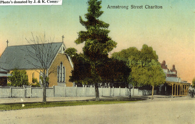
Photograph, St Martin's Anglican Church, Armstrong St Charlton
... Pastoral Care St Martin's Angllican Church Armstrong Street Charlton Copy of a coloured (hand coloured?) post card showing St Martin's Anglican Church, Armstrong St, Charlton. The church is a yellow, timber building with a cross at each end of the roof. A white picket fence runs ...St Martin's Anglican Church was built in 1889. Victoria Hall was built for E. Miles in 1884. The post card is part of a series taken c. 1907.Copy of a coloured (hand coloured?) post card showing St Martin's Anglican Church, Armstrong St, Charlton. The church is a yellow, timber building with a cross at each end of the roof. A white picket fence runs along the front of the church. There are three trees on the edge of the road in front of the church. There is a large single storey red brick building to the right of the church with a verandah over the footpath. A horse is coming down the road past the red brick building. The post card has Armstrong Street Charlton in the top right. There is a typed note in the top LH corner of the photo that says Photo's donated by J. & K. Cossar.pastoral care, st martin's, angllican, church, armstrong street, charlton -
 Charlton Golden Grains Museum Inc
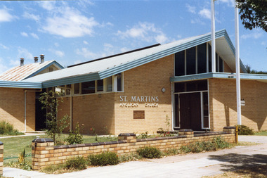
Photograph, Charlton Shire, St Martin's Anglican Church c. 1989, c.1989
... Pastoral Care Colour photo of St Martins Anglican Church. White brick single storey building with an iron roof and blue fascia trim. There is a dark coloured double door with windows on either side and above it. There are large clerestory windows on the front and side of the building. A low pale brick fence capped with darker brick runs ...The current St Martins Anglican Church was built in 1963 to replace the first weatherboard church built in 1889. Shire of Charlton photo c. 1989.Colour photo of St Martins Anglican Church. White brick single storey building with an iron roof and blue fascia trim. There is a dark coloured double door with windows on either side and above it. There are large clerestory windows on the front and side of the building. A low pale brick fence capped with darker brick runs beside the footpath. An older weatherboard building with a rusty iron roof is partially visible behind the main church building. st martin's anglican church, church, angllican, pastoral care -
 Wodonga & District Historical Society Inc
Book - The First Settlement of the Upper Murray 1835 to 1845, Dr. Arthur Andrews, 1979
... Wodonga & District Historical Society Inc Hut 97, Bonegilla Migrant Experience, 132 Bonegilla Road Bonegilla the-murray This book is significant because it details earlier settlers and holdings in Northeast Victoria. upper murray district settlement victoria colonial settlement pastoral industry victoria A history of settlement on and around the Upper Murray River, covering the period of 1835 to 1845, including "A short account of over two hundred runs 1835 to 1880". ...A history of settlement on and around the Upper Murray River, covering the period of 1835 to 1845, including "A short account of over two hundred runs 1835 to 1880". An excellent source of information on the colonial settlement of the Murray River. Detailed information of the first white settlers and the challenges they faced. Interesting account of conflict between settlers and indigenous population. Many indigenous words and their meaning recorded. It includes a foreword written by Rosemary Boyes, a prominent Albury-Wodonga historian.A small hardcovered book of 181 pages and an index including information of early settlers and runs in Northeast Victoria.non-fictionA history of settlement on and around the Upper Murray River, covering the period of 1835 to 1845, including "A short account of over two hundred runs 1835 to 1880". An excellent source of information on the colonial settlement of the Murray River. Detailed information of the first white settlers and the challenges they faced. Interesting account of conflict between settlers and indigenous population. Many indigenous words and their meaning recorded. It includes a foreword written by Rosemary Boyes, a prominent Albury-Wodonga historian.upper murray district, settlement victoria, colonial settlement, pastoral industry victoria -
 Wodonga & District Historical Society Inc
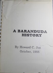
Book - A Baranduda History, Howard C Jones, 1988
... This publication traces the history of the area from its earliest know indigenous inhabitants, through the days of the earlier establishment of pastoral runs to more recent developments. Spiral bound A Baranduda History Book A Baranduda History Howard C Jones Albury Wodonga Development Corporation ...A history of Baranduda in Northeast Victoria. Baranduda is a rural area and, since the 1970s, a rural and residential locality formed under the authority of the Albury Wodonga Development Corporation. It is near the junction of Yackandandah Road and the Kiewa Valley Highway, 10 km south-east of Wodonga. This publication traces the history of the area from its earliest know indigenous inhabitants, through the days of the earlier establishment of pastoral runs to more recent developments.Spiral boundnon-fictionA history of Baranduda in Northeast Victoria. Baranduda is a rural area and, since the 1970s, a rural and residential locality formed under the authority of the Albury Wodonga Development Corporation. It is near the junction of Yackandandah Road and the Kiewa Valley Highway, 10 km south-east of Wodonga. This publication traces the history of the area from its earliest know indigenous inhabitants, through the days of the earlier establishment of pastoral runs to more recent developments.baranduda, pioneers victoria, huon family, wodonga pioneers -
 Ballarat Heritage Services
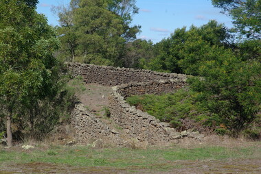
Photograph - Colour, Bessibelle Drystone Sheep Wash, 2016, 24/04/2016
... runs, and the sheep washes were located within Mount Eccles and Lake Gorrie Run. The date of construction of the washes and walls is not known, although they were probably constructed within the period 1848-1864. The Bessiebelle Sheepwashes and Yards are probably the largest and most sophisticated surviving example of a traditional pastoral...runs, and the sheep washes were located within Mount Eccles and Lake Gorrie Run. The date of construction of the washes and walls is not known, although they were probably constructed within the period 1848-1864. The Bessiebelle Sheepwashes and Yards are probably the largest and most sophisticated surviving example of a traditional pastoral ...The Bessiebelle Sheepwashes and Yards complex is located on the former 14,000 acre Ardonachie Run, established in 1848 by pastoralist Samuel Gorrie, then carrying 6,000 sheep. In 1864 this run was subdivided into smaller runs, and the sheep washes were located within Mount Eccles and Lake Gorrie Run. The date of construction of the washes and walls is not known, although they were probably constructed within the period 1848-1864. The Bessiebelle Sheepwashes and Yards are probably the largest and most sophisticated surviving example of a traditional pastoral property sheepwash in Victoria. They clearly demonstrate the large network of races, yards and folds necessary for washing thousands of sheep over a short period of time. The Bessiebelle sheep washes apparently predate later technological changes and the necessity for hot water washing. The Bessiebelle sheepwashes and yards are of landscape significance as a cultural landscape which has been both modified by, and cleverly adapted to, an annual process that was of critical importance within the pastoral calendar. The drystone walls and races appear to evolve from the rocky terrain, and have a strong organic affinity with the prevailing harsh landscape. The drystone walls demonstrate a high level of craftsmanship and skill in their construction, and reflect the extensive scale of pastoral operations across the landscape. The Bessiebelle sheepwashes and yards are of archaeological significance to the State of Victoria. The site has not been fully surveyed but its complexity strongly suggests a potential to reveal more about the washing processes and associated pastoral occupation and activity in the area.(Heritage Victoria)drystone, bessibell, sheep race, sheep wash, agriculture -
 Narre Warren and District Family History Group
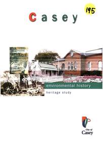
Book, Graeme Butler & Associates, City of Casey Heritage Study : Environmental History, 1998
... Manufacturing The study highlights the rich history and development of the City of Casey, showcasing its transformation from a region of Aboriginal occupation and pastoral runs to a modern city with diverse industries, residential estates, and cultural heritage. ...A comprehensive environmental history of the City of Casey, covering its heritage, development, and key historical aspects. Some of the themes explored are: 1. Explorers and First Contact 2. Peopling the Continent 3. Promoting Settlement 4. Developing Primary Production 5. Exploiting Natural Resources 6. Building Settlements 7. Governing and Administrative Structures 8. Altering the Environment 9. Communication and Transport 10. Education 11. Recreation 12. Manufacturing The study highlights the rich history and development of the City of Casey, showcasing its transformation from a region of Aboriginal occupation and pastoral runs to a modern city with diverse industries, residential estates, and cultural heritage. This publication can be downloaded from the City of Casey website.non-fictionA comprehensive environmental history of the City of Casey, covering its heritage, development, and key historical aspects. Some of the themes explored are: 1. Explorers and First Contact 2. Peopling the Continent 3. Promoting Settlement 4. Developing Primary Production 5. Exploiting Natural Resources 6. Building Settlements 7. Governing and Administrative Structures 8. Altering the Environment 9. Communication and Transport 10. Education 11. Recreation 12. Manufacturing The study highlights the rich history and development of the City of Casey, showcasing its transformation from a region of Aboriginal occupation and pastoral runs to a modern city with diverse industries, residential estates, and cultural heritage. This publication can be downloaded from the City of Casey website.lysterfield reservoir, koo wee rup swamp, berwick (vic.), endeavour hills (vic.), cranbourne (vic.), narre warren north (vic.), tooradin (vic.), hampton park (vic.), doveton (vic.)