Showing 127 items matching "pleasant street south"
-
 City of Ballarat Libraries
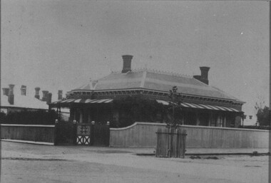
Photograph, "Wuurna" 1321 Sturt Street
... ...pleasant street south...Along with 1319 Sturt Street, the house was demolished and an Shell Service Station was built in 1962. building private residence wuurna thomas p. wilson margaret wilson pleasant street south "Wuurna" 1321 Sturt Street Photograph Photograph ..."Wuuran" was built for Thomas P. Wilson in 1910. The second photo shows Thomas and his wife, Margaret in 1932. The house had a conservatory, ironstone path and a trellis gate to the backyard and a large timber garage. Along with 1319 Sturt Street, the house was demolished and an Shell Service Station was built in 1962.building, private residence, wuurna, thomas p. wilson, margaret wilson, pleasant street south -
 Stawell Historical Society Inc
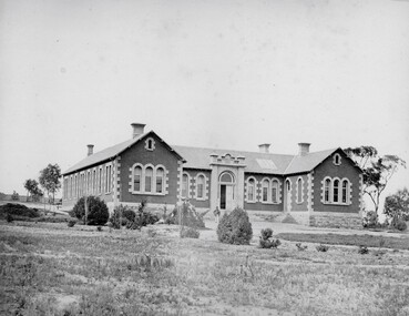
Photograph, Pleasant Creek Hospital 1866
... Pleasant Creek. A temporary Tent structure was soon erected at Doctors Hill, situated midway between Deep Lead and Commercial Street Pleasant Creek, just South of the later Western Highway. ...Pleasant Creek. A temporary Tent structure was soon erected at Doctors Hill, situated midway between Deep Lead and Commercial Street Pleasant Creek, just South of the later Western Highway. ...Pleasant Creek Hospital. Part of a collection of Photographs by Mr. O.G. Armstrong as commissioned by the Shire of Stawell for the Inter-colonial and Paris Exhibition in Melbourne in 1866. Due to a public outcry for medical services on the goldfield a public meeting was held in the Olympic Theatre at Deep Lead on the 7th of August 1858. It appointed a 50 man committee to establish a hospital at Pleasant Creek. A temporary Tent structure was soon erected at Doctors Hill, situated midway between Deep Lead and Commercial Street Pleasant Creek, just South of the later Western Highway. The site is now marked by a commemorative stone. Within two months the committee had collected £600 in subscriptions, a government Grant for £2500 and acquired 10 acres of land. The foundation stone of the hospital building was laid on 21st December 1860 and the building completed and occupied by 21st June 1861. In the 1930’s the hospital moved to the centre of Stawell in Sloane Street and the buildings then taken over by the Pleasant Creek Training Centre. Brick hospital building with two ward wings and central front door. Man standing on steps.stawell health -
 Warrnambool and District Historical Society Inc.
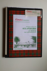
Archive (collection) - Elmac Hydroponics business material, Elmac Hydroponics, 2004
... Warrnambool and District Historical Society Inc. 2 Gilles Street (south of Merri St) Warrnambool great-ocean-road Elmac Hydroponics was a business based at 'Mt Pleasant', Princes Highway, Allansford, Victoria from 1996 to 2004. ...Business owners collectionCollected for archival reasonsMaterial in foldernewspaper cuttings, certificates, photographs, articles re the business operationswestern district industries, warrnambool, elmac hydroponicswestern district industries, warrnambool, elmac hydroponics -
 Warrnambool and District Historical Society Inc.
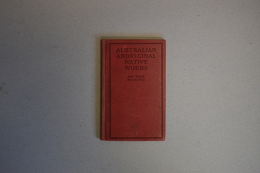
Book, Australian Aboriginal Native Words and Their Meanings, 1925
... Warrnambool and District Historical Society Inc. 2 Gilles Street (south of Merri St) Warrnambool great-ocean-road This book was published by the Commonwealth of Australia in 1925 with the purpose of listing aboriginal names that were 'pleasant-sounding' with the suggestion that they could be used as place or house names in Australia. ...Aboriginal words and their English meaningsThis is a book of 48 pages. It has a red cover with black printing. The pages contain printed material and black and white photographs.non-fictionAboriginal words and their English meaningsaustralian aboriginal words and their meaning -
 Warrnambool and District Historical Society Inc.
Medallion, Trophy Environmental achievement, 2000
... Street (south of Merri St) Warrnambool great-ocean-road This is a medallion awarded in 2000 by Powercor Warrnambool to Elmac Hydroponics. Powercor Australia, founded in 1994, is an electrical distribution company operating in the Western District of Victoria and the western suburbs of Melbourne. Powercor Warrnambool, like other Powercor organizations, is involved in giving Business Excellence Awards annually to businesses in its area of supply. In 2014 there were 15 awards for Business Excellence. Elmac Hydroponics was a business growing and supplying organically-produced tomatoes from 1997 to 2004. It was situated at Mount Pleasant ...This is a medallion awarded in 2000 by Powercor Warrnambool to Elmac Hydroponics. Powercor Australia, founded in 1994, is an electrical distribution company operating in the Western District of Victoria and the western suburbs of Melbourne. Powercor Warrnambool, like other Powercor organizations, is involved in giving Business Excellence Awards annually to businesses in its area of supply. In 2014 there were 15 awards for Business Excellence. Elmac Hydroponics was a business growing and supplying organically-produced tomatoes from 1997 to 2004. It was situated at Mount Pleasant, Princes Highway, Allansford, Victoria. The business was operated by Graeme and Barbara McLeod and Keith and Leonie Ellerton. Hydroponics is a system of growing plants without soil, using a nutrient solution. Elmac Hydroponics had a 2,000 square metre greenhouse with 10,000 growing points. This is a significant medallion, showing the award given to a small business in the Warrnambool area and indicating its achievements in the environmental area. Elmac was an industry leader in in implementing an ‘Autopot’ hydroponic system which is aimed at reducing nutrient and waste water to zero. Elmac was also a finalist in the Ericsson 2002 Innovation Awards.This is a gilt metal medallion, oval-shaped, with an ornamental edging and a shield-shaped design on one side and a circular design on the other. The top has two metal rings for attachment to a chain or wall hook. On one side: ‘Environmental Achievement, Elmac Hydroponics’ On obverse side: ‘Powercor Warrnambool Region Business Achievement Awards, 2000’ elmac hydroponics, powercor business awards, warrnambool -
 Warrnambool and District Historical Society Inc.
Textile - Fire screen, Tapestry, Post 1967
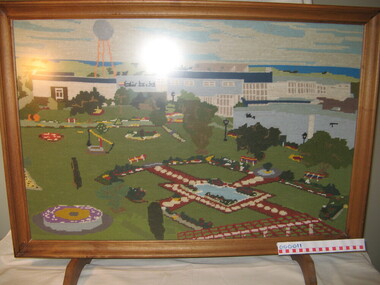
... Warrnambool and District Historical Society Inc. 2 Gilles Street (south of Merri St) Warrnambool great-ocean-road David Fletcher Jones (1895-1977) was a travelling hawker who opened a business in Liebig Street, Warrnambool in 1924. In 1931 he opened The Man's Shop at the corner of Liebig Street and Koroit Street. He sold suits and overcoats tailored in the work rooms upstairs. In 1948 his factory known as Pleasant ...David Fletcher Jones (1895-1977) was a travelling hawker who opened a business in Liebig Street, Warrnambool in 1924. In 1931 he opened The Man's Shop at the corner of Liebig Street and Koroit Street. He sold suits and overcoats tailored in the work rooms upstairs. In 1948 his factory known as Pleasant Hill was opened in Flaxman Street in Warrnambool, the site of an old quarry. In 1951 the company Fletcher Jones and Staff was formed with the staff owning 51% of the shares, By the 1970s Fletcher Jones and Staff had become one of the largest clothing companies in Australia with 55 shops and 3000 employees. In 1992 the Warrnambool City Council bought the factory and gardens with the site now a tourist attraction. Although the name is retained today for trading purposes the original Fletcher Jones company has been dissolved. The screen is a representation of the Fletcher Jones factory post 1967. It a wool tapestry by Martin Prider who was a painter and caretaker what the Fletcher Jones factory. He lived in one of the Fletcher Jones cottages on site. (Robin Boyd Age Small Homes Scheme, today Heritage listed.)This is an interesting memento of the Fletcher Jones company and the factory. It was done by a local resident and features the famous Fletcher Jones gardensTapestry fire screen in a rectangular light timber frame depicting the Fletcher Jones Factory Gardens. The screen has two timber feet, non relective glass and appears to be a wool tapestry. The image of the gardens is after 1967 as the silver ball is included and that was erected in 1967. Nilfletcher jones company and warrnambool factory, pleasant hill warrnambool, martin prider, fletcher jones, tapestry of fletcher jones factory -
 Warrnambool and District Historical Society Inc.
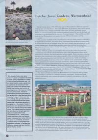
Article - Fletcher Jones Gardens Warrnambool, 1993
... Street (south of Merri St) Warrnambool great-ocean-road The article gives an overview of the development of the landscaping of factory gardens in the early part of the 20th century. The Fletcher Jones Gardens feature strongly and a brief history is given of the establishment of the Fletcher Jones factory. Fletcher Jones Factory held a significant place in the economic development of the city. The Fletcher Jones Gardens remain a significant landmark in the city warrnambool fletcher jones pleasant ...The article gives an overview of the development of the landscaping of factory gardens in the early part of the 20th century. The Fletcher Jones Gardens feature strongly and a brief history is given of the establishment of the Fletcher Jones factory. Fletcher Jones Factory held a significant place in the economic development of the city. The Fletcher Jones Gardens remain a significant landmark in the cityArticle titled “Fletcher Jones Gardens Warrnambool,” printed with blue background. Three coloured photographs showing different vistas of the gardens.warrnambool, fletcher jones, pleasant hill, fletcher jones gardens -
 Warrnambool and District Historical Society Inc.
Domestic object - Fletcher Jones Coat Hanger, Late 20th century
... Street (south of Merri St) Warrnambool great-ocean-road David Fletcher Jones commenced his tailoring and hawking business in the 1920’s. The business expanded through the decades to become the main manufacturing employer in the city of Warrnambool. The business moved from Liebig Street around 1947 to a site in East Warrnambool which was once an old quarry. The factory which was built at “Pleasant ...David Fletcher Jones commenced his tailoring and hawking business in the 1920’s. The business expanded through the decades to become the main manufacturing employer in the city of Warrnambool. The business moved from Liebig Street around 1947 to a site in East Warrnambool which was once an old quarry. The factory which was built at “Pleasant Hill” manufactured quality clothing, initially men’s trousers, suits which expanded in later times to include ladies’ wear. A network of stores was opened throughout Australia to sell the garments. A common item linked to a significant business and personality of Warrnambool.Fletcher Jones Factory held a significant place in the economic development of the city. The Fletcher Jones Gardens remain a significant landmark in the cityBlack plastic coat hanger with metal hook. Fletcher Jones in gold lettering below the hook.warrnambool, fletcher jones, pleasant hill, fletcher jones gardens, coathanger -
 Warrnambool and District Historical Society Inc.
Bottle Blue, Druggist and Manufacturer, 1889
... Warrnambool and District Historical Society Inc. 2 Gilles Street (south of Merri St) Warrnambool great-ocean-road This bottle was made by Whitall and Tatum who manufactured bottles from the early 1800's through to the 1930's. They specialised in producing chemist bottles and this particular cobalt blue bottle is on of the more rarely produced bottles. This syrup forms a cooling and pleasant ...This bottle was made by Whitall and Tatum who manufactured bottles from the early 1800's through to the 1930's. They specialised in producing chemist bottles and this particular cobalt blue bottle is on of the more rarely produced bottles. This syrup forms a cooling and pleasant addition to beverages for patients with febrile complaints, and serves to conceal the taste of saline purgatives in solution. It is made by steeping lemon juice and skin in a sugar syrup and alcohol. We are unsure of the particular chemist to whom it belonged.A fine example of a late 19th century bottle which was used and owned by a Warrnambool business.Square cobalt blue glass bottle with rounded neck and lip with round stopper with narrow section in the middle.Printed paper label with red and gold border and mainly black text, is attached to rectangular section which is indented on one side.It has a fine line through the centre of the bottle from the process of manufacturing.Label: Warrnambool Wholesale Druggists & manufacturi chemist. handwritten on label Syr Limonis. On bottom of bottle: Pat apr2 1889 W T & Co.warrnambool, warrnambool chemist, chemist bottle -
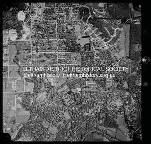
 Eltham District Historical Society Inc
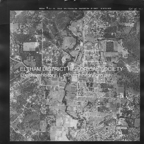
Photograph - Aerial Photograph, Landata, Eltham, Main Road; Mt Pleasant Rd to Railway Rd, Dec. 1945
... Centred on Main Rd and Henry St, Eltham bounded by Railway Road to north, Mount Pleasant Road at Main Road to south, top of the hill in Arthur Street to east and Karingal Drive at Sherbourne Road to west. ...Eltham District Historical Society Inc 728 Main Rd Eltham melbourne Centred on Main Rd and Henry St, Eltham bounded by Railway Road to north, Mount Pleasant Road at Main Road to south, top of the hill in Arthur Street to east and Karingal Drive at Sherbourne Road to west. ...Centred on Main Rd and Henry St, Eltham bounded by Railway Road to north, Mount Pleasant Road at Main Road to south, top of the hill in Arthur Street to east and Karingal Drive at Sherbourne Road to west. Historic Aerial Imagery Source: Landata.vic.gov.au Aerial Photo Details: Project No :65 Project : MELBOURNE AND METROPOLITAN PROJECT NO. 2 Run : 8 Frame : 70 Date : 01/1951 Film Type : B/W Camera : EAG9 Flying Height : 12200 Scale : 12000 Film Number : 1419 GDA2020 : 37°43'06"S, 145°08'45"E MGA2020 : 336589, 5823811 (55) Melways : 21 J6 (ed. 42)aerial photo, eltham, main road, henry street, arthur street, bolton street, eltham-yarra glen road, neil webster collection, 1951-01, dave lyon house, ernie andrew house, karingal road, melway 21j6, mount pleasant road, railway road -
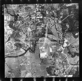
 Eltham District Historical Society Inc
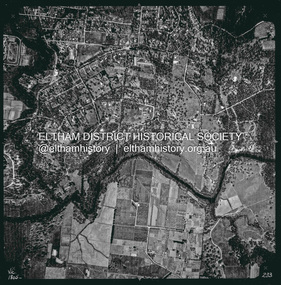
Photograph - Aerial Photograph, Landata, Eltham, Vic, Apr. 1963
... Centred on present day Griffith Park Road, Eltham bounded by Mount Pleasant Road to north, Yarra River and Templestowe to south, Main Road at Reynolds Road to east and Falkiner Street to west. ...Eltham District Historical Society Inc 728 Main Rd Eltham melbourne Centred on present day Griffith Park Road, Eltham bounded by Mount Pleasant Road to north, Yarra River and Templestowe to south, Main Road at Reynolds Road to east and Falkiner Street to west. ...Centred on present day Griffith Park Road, Eltham bounded by Mount Pleasant Road to north, Yarra River and Templestowe to south, Main Road at Reynolds Road to east and Falkiner Street to west. Historic Aerial Imagery Source: Landata.vic.gov.au Aerial Photo Details: Project No :486 Project : MELBOURNE (1963) PROJECT Run : 7 Frame : 233 Date : 04/1963 Film Type : B/W Camera : RC8 Flying Height : 5100 Scale : 9600 Film Number : 1805 GDA2020 : 37°44'04"S, 145°09'10"E MGA2020 : 337237, 5822053 (55) Melways : 22 A10 (ed. 42)aerial photo, neil webster collection, 1963-04, eltham, falkiner street, griffith park road, melway 22a10, mount pleasant road, reynolds road, templestowe, yarra river -
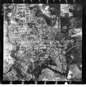
 Eltham District Historical Society Inc
Photograph - Aerial Photograph, Landata, Eltham, Vic, Apr. 1972
... Centred on present day Dalton Street at Mount Pleasant Road, Eltham bounded by Arthur Street to north, Yarra River and Kent Hughes Road to south, Eucalyptus Road to east and Susan Street to west. ...Eltham District Historical Society Inc 728 Main Rd Eltham melbourne Centred on present day Dalton Street at Mount Pleasant Road, Eltham bounded by Arthur Street to north, Yarra River and Kent Hughes Road to south, Eucalyptus Road to east and Susan Street to west. ...Centred on present day Dalton Street at Mount Pleasant Road, Eltham bounded by Arthur Street to north, Yarra River and Kent Hughes Road to south, Eucalyptus Road to east and Susan Street to west. Historic Aerial Imagery Source: Landata.vic.gov.au Aerial Photo Details: Project No :985 Project : MELBOURNE 1972 Run : 28 Frame : 208 Date : 04/1972 Film Type : B/W Camera : RC10 Flying Height : 5700 Scale : 9600 Film Number : 2635 GDA2020 : 37°43'29"S, 145°08'54"E MGA2020 : 336816, 5823118 (55) Melways : 21 J8 (ed. 42)aerial photo, neil webster collection, 1972-04, eltham, arthur street, dalton street, eucalyptus road, kent hughes road, melway 21j8, mount pleasant road, susan street, yarra river -
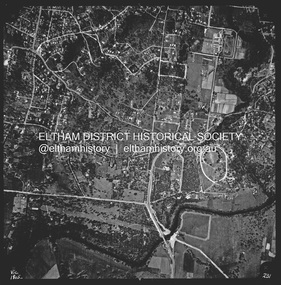
 Eltham District Historical Society Inc
Photograph - Aerial Photograph, Landata, Eltham, Feb. 1956
... Centred on present day Culla Hill and Petty's Orchard, Eltham bounded by Brougham Street and Mount Pleasant Road to north, Monckton Road, Templestowe to south, Reynolds Road to east and Eltham Lower Park and Hohnes Road to west. ...Eltham District Historical Society Inc 728 Main Rd Eltham melbourne Centred on present day Culla Hill and Petty's Orchard, Eltham bounded by Brougham Street and Mount Pleasant Road to north, Monckton Road, Templestowe to south, Reynolds Road to east and Eltham Lower Park and Hohnes Road to west. ...Centred on present day Culla Hill and Petty's Orchard, Eltham bounded by Brougham Street and Mount Pleasant Road to north, Monckton Road, Templestowe to south, Reynolds Road to east and Eltham Lower Park and Hohnes Road to west. Historic Aerial Imagery Source: Landata.vic.gov.au Aerial Photo Details: Project No :250 Project : MELBOURNE OUTER SUBURBS PROJECT Run : 18 Frame : 92 Date : 02/1956 Film Type : B/W Camera : EAG9 Flying Height : 10000 Scale : 12000 Film Number : 1176 GDA2020 : 37°43'35"S, 145°09'31"E MGA2020 : 337735, 5822959 (55) Melways : 22 B8 (ed. 42)aerial photo, 1956-02, neil webster collection, eltham, brougham steet, culla hill, eltham lower park, hohnes road, melway 22b8, monckton road, mount pleasant road, petty's orchard, reynolds road, sweeneys lane, templestowe, yarra river -
 Eltham District Historical Society Inc
Photograph - Aerial Photograph, Landata, Eltham, Feb. 1956
... Eltham District Historical Society Inc 728 Main Rd Eltham melbourne Centred on present day Mount Plaeasant Road near Dalton Street, Eltham bounded by Luck Street to north, Eltham Lower Park to south, Reynolds Road to east and Central Park to west Historic Aerial Imagery Source: Landata.vic.gov.au Aerial Photo Details: Project No :250 Project : MELBOURNE OUTER SUBURBS PROJECT Run : 18 Frame : 93 Date : 02/1956 Film Type : B/W Camera : EAG9 Flying Height : 10000 Scale : 12000 Film Number : 1176 GDA2020 : 37°43'02"S, 145°09'38"E MGA2020 : 337871, 5823961 (55) Melways : 22 B6 (ed. 42) Aerial Photo 1956-02 Neil Webster Collection Eltham Central Park Eltham Lower Park Luck Street Melway 22B6 Nyora Road Reynolds Road Dalton Street Mount Pleasant Road Digital jpg and electronic PDF file Eltham Photograph Aerial Photograph Landata ...Centred on present day Mount Plaeasant Road near Dalton Street, Eltham bounded by Luck Street to north, Eltham Lower Park to south, Reynolds Road to east and Central Park to west Historic Aerial Imagery Source: Landata.vic.gov.au Aerial Photo Details: Project No :250 Project : MELBOURNE OUTER SUBURBS PROJECT Run : 18 Frame : 93 Date : 02/1956 Film Type : B/W Camera : EAG9 Flying Height : 10000 Scale : 12000 Film Number : 1176 GDA2020 : 37°43'02"S, 145°09'38"E MGA2020 : 337871, 5823961 (55) Melways : 22 B6 (ed. 42)aerial photo, 1956-02, neil webster collection, eltham, central park, eltham lower park, luck street, melway 22b6, nyora road, reynolds road, dalton street, mount pleasant road -
 Eltham District Historical Society Inc
Photograph - Aerial Photograph, Landata, Lower Plenty, Vic, Apr. 1963
... Centred on present day Old Eltham Road near Araluen Centre, Lower Plenty bounded by Cromwell Street to north, Yarra River to south, Main Road at Mount Pleasant Road to east and Panorama Avenue to west. ...Eltham District Historical Society Inc 728 Main Rd Eltham melbourne Centred on present day Old Eltham Road near Araluen Centre, Lower Plenty bounded by Cromwell Street to north, Yarra River to south, Main Road at Mount Pleasant Road to east and Panorama Avenue to west. ...Centred on present day Old Eltham Road near Araluen Centre, Lower Plenty bounded by Cromwell Street to north, Yarra River to south, Main Road at Mount Pleasant Road to east and Panorama Avenue to west. Historic Aerial Imagery Source: Landata.vic.gov.au Aerial Photo Details: Project No :486 Project : MELBOURNE (1963) PROJECT Run : 7 Frame : 231 Date : 04/1963 Film Type : B/W Camera : RC8 Flying Height : 5100 Scale : 9600 Film Number : 1805 GDA2020 : 37°44'03"S, 145°07'56"E MGA2020 : 335420, 5822027 (55) Melways : 21 F10 (ed. 42)aerial photo, neil webster collection, 1963-04, araluen, cromwell street, eltham, lower plenty, main road, melway 21f10, mount pleasant road, old eltham road, panorama avenue, yarra river -
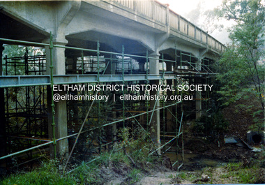 Eltham District Historical Society Inc
Photograph, Ruth H. Pendavingh, Reconstruction of Main Road from Main Road Bridge to Mount Pleasant Road, Eltham, 1984
... Street by the Road Construction Authority in 1984. The upgraded bridge was re-opened October 25, 1984, 78 years after its original opening. (EDHS Chronology of known local events 1835- early 2000) 1984 bridge construction Diamond Creek (Creek) Eltham South Main Road main road bridge Road construction Three colour photograph prints Reconstruction of Main Road from Main Road Bridge to Mount Pleasant Road, Eltham Photograph Photograph Ruth H. ...The original timber bridge over the Diamond Creek was built around 1840. It was destroyed by floodwaters in October 1923. A temporary bridge was rigged up but further damaged in April 1924. A new concrete bridge was built and opened in October 1926. The bridge decking was widened along with Main Road to Dalton Street by the Road Construction Authority in 1984. The upgraded bridge was re-opened October 25, 1984, 78 years after its original opening. (EDHS Chronology of known local events 1835- early 2000)Three colour photograph prints 1984, bridge construction, diamond creek (creek), eltham south, main road, main road bridge, road construction -
 Bendigo Historical Society Inc.
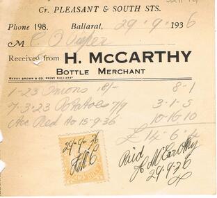
Document - PIEPER COLLECTION: INVOICE H. MCCARTHY BOTTLE MERCHANT
... Street Bendigo goldfields BUSINESS Retail H. McCarthy bottlemerchant Invoice issued by H. McCarthy, bottle merchant, Pleasant and South Sts, Ballarat. to Mr. ...Invoice issued by H. McCarthy, bottle merchant, Pleasant and South Sts, Ballarat. to Mr. C.O. Pieper, on 29.9.36, for onions and potatoes. Receipt attached on bottom of invoice.business, retail, h. mccarthy bottlemerchant -
 Eltham District Historical Society Inc
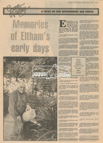
Newsclipping, Linley Hartley, Memories of Eltham's early days by Linley Hartley; picture by Ron Grant, Diamond Valley News, 13 August 1985, p37, 13 Aug 1985
... Street...Eltham Hotel...Eltham Kindergaten...Eltham Lower Park...Eltham Primary School...Eltham Railway Station...Eltham South Kindergarten...eltham tea rooms...Farmer Walsh...franklin street...freddie griffiths...greengrocer...Grocers...Eltham Infant Welfare Centre...Irene Rennie Harrison...jack carrucan...josie shannon...Justus Jorgensen...Len Harrison...Main Road...Markets...Matcham skipper...Metery Road...Milk Bar...Montsalvalt...Mount Pleasant...Eltham District Historical Society Inc 728 Main Rd Eltham melbourne Memories of Mrs Irene "Rennie" Harrison 1939 bushfire Alf Isherwood Annie Bremmer Arthur Munday Beryl Bradbury (nee Stokes) Collection Bible Street Bremmer's Flat buses butcher Cheddar Black Clarrie White Collis Dalton Street Eltham Hotel Eltham Kindergaten Eltham Lower Park Eltham Primary School Eltham Railway Station Eltham South Kindergarten eltham tea rooms Farmer Walsh franklin street freddie griffiths greengrocer Grocers Eltham Infant Welfare Centre Irene Rennie Harrison jack carrucan josie shannon Justus Jorgensen Len Harrison Main Road Markets Matcham skipper Metery Road Milk Bar Montsalvalt Mount Pleasant road Shirley Harrison St Margaret's church hall Wingrove Park reminscences Digital file only - Digitised by EDHS from a scrapbook on loan from Beryl Bradbury (nee Stokes), daughter of Frank Stokes. ...Memories of Mrs Irene "Rennie" HarrisonDigital file only - Digitised by EDHS from a scrapbook on loan from Beryl Bradbury (nee Stokes), daughter of Frank Stokes.1939 bushfire, alf isherwood, annie bremmer, arthur munday, beryl bradbury (nee stokes) collection, bible street, bremmer's flat, buses, butcher, cheddar black, clarrie white, collis, dalton street, eltham hotel, eltham kindergaten, eltham lower park, eltham primary school, eltham railway station, eltham south kindergarten, eltham tea rooms, farmer walsh, franklin street, freddie griffiths, greengrocer, grocers, eltham infant welfare centre, irene rennie harrison, jack carrucan, josie shannon, justus jorgensen, len harrison, main road, markets, matcham skipper, metery road, milk bar, montsalvalt, mount pleasant road, shirley harrison, st margaret's church hall, wingrove park, reminscences -
 Eltham District Historical Society Inc
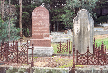
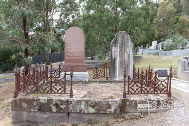
Negative - Photograph, Harry Gilham, Graves of William J and Mary Jane (nee Vance) Crozier and their sons Thomas Vance and John McClelland Crozier, Eltham Cemetery, Victoria, 1 Aug 2007
... It was situated on twenty-four acres along the track at its rise, about half-a-mile east of Maria Street (Main Road) bounded by Mt Pleasant Road on the south and Pitt Street northwards. ...It was situated on twenty-four acres along the track at its rise, about half-a-mile east of Maria Street (Main Road) bounded by Mt Pleasant Road on the south and Pitt Street northwards. ...William Crozier was born 1823 in County Armagh, Ireland. Mary Jane Vance was born 1829 in Desecrete, County Tyrone, Ireland. They were married in 1848. On New Year's Eve, 1849, together with their baby daughter Sarah, William and Mary embarked from Plymouth aboard the Eliza Caroline, as assisted immigrants, for Port Phillip, arriving 31 March 1850 from where they journeyed out to Eltham on a bullock wagon. The Croziers were Episcopalians and soon after arriving in Eltham the Wesleyans of Little Eltham were holding services in the Crozier's home, among other locations. It was not until January 1856 that the Wesleyan church first acquired land in Henry Street for a chapel, which later became the home of the Eltham Hall. The Crozier home, known as ‘Belmont’ was weatherboard with a rammed earth floor. It was situated on twenty-four acres along the track at its rise, about half-a-mile east of Maria Street (Main Road) bounded by Mt Pleasant Road on the south and Pitt Street northwards. William Crozier used the land for cultivation and grazing. The track the Eltham Wesleyans took, by foot or horse, was along the Mt Pleasant Road, and like most roads of the time, a dusty trail in summer and a hoof and cart rutted quagmire in winter. William and Mary Crozier had seven children: Sarah, (1848 Ireland), John McClelland (1851 Eltham), Eliza (1855 Eltham), William (1857 Eltham), Jane(1859 Yarraville), Charlotte Amelia (1861 Yarraville), and Thomas Vance (1864 Eltham). The Crozier farm prospered and in 1870, William applied for, and was granted a leasehold on an additional sixty-three-acre selection, half-a-mile east of his twenty-four-acre Mt Pleasant Road property. Upon this property he built a two-roomed dwelling of slats and bark and a storeroom of log and bark, ten feet square. In 1880 he applied for a Crown grant of the property. Tragedy struck the family in 1882 when the youngest, Thomas Vance at age 17 accompanied by John Anderson, went into "Hall's Dam" to bathe, neither of them being able to swim. On wading out together, Crozier suddenly slipped into a part about 10ft. deep, and sank, after rising only once. Anderson pluckily tried to save him, nearly losing his own life in the attempt, saving himself when sinking for the last time by seizing hold of a projecting root. The body was not recovered until two hours after, when Mr. Thomas Bell, a farmer in the locality, who was attracted to the spot, on hearing of the occurrence, although unable to swim, plunged in with a rope around his waist, and succeeded with some difficulty in bringing it to the surface. Their eldest son, John also died prematurely at age 42 when he was killed by a falling tree branch whilst engaged in ring-barking trees at Eltham. A still cold wind was blowing and John, and others who were working with him, sheltered themselves at lunch time by sitting on the side of a large tree. When thus seated, the wind detached a limb of the tree which sheltered them, and though they heard the cracking, they had not time to get clear before the limb fell. It struck John on the head, and felled him to the ground, He appeared to be suffering severe pain, and two of his companions conveyed him to the Melbourne Hospital, where during the night he was operated upon for a fracture of the skull. Despite the operation being successful, John ultimately succumbed to his injuries the following afternoon. In good times William was known for his wealth of reminiscences of the early days of the district however his health failed him for several years until his death in March 1909. He was a man of very industrious habits, of a retiring disposition and much esteemed by those who knew him best. Mary died in January 1915 after a long illness. They are buried together along with their sons John and Thomas in the Eltham Cemetery. In Loving Remembrance William Beloved husband of Mary Jane Crozier Who departed this life March 31st 1909, aged 85 years Also Mary Jane Beloved wife of the above Who departed this life January 3rd 1915, aged 86 years Also John McCelland Son of the above Who departed this life May 20th 1894, aged 42 years also Sacred Memory of Thomas Vance Dearly beloved son of William J. Crozier Who departed this life at Eltham, February 3rd 1882 Aged 17 yearseltham cemetery, gravestones, memorials, film - kodak gold gc 400-9, john mccelland crozier, mary jane crozier (nee vance), scan - 35mm negative, thomas vance crozier, william crozier, william j crozier -
 Eltham District Historical Society Inc
Negative - Photograph, Main Road, Eltham, c.1915
... Street near Main Road. The church site was relocated c.1912 from further south along Main Road (near Wingrove Cottage) in order to be more central to the congregation following the shifting of the township away from Little Eltham and closer to the railway station. It was subsequently destroyed by fire in 1961. On the back of the postcard is written: Printed Post Empire Care - correspondence - Address only - stamp Written in ink: 15 ? 1920 Many happy of the day I hope you and ? will have a very pleasant...Street near Main Road. The church site was relocated c.1912 from further south along Main Road (near Wingrove Cottage) in order to be more central to the congregation following the shifting of the township away from Little Eltham and closer to the railway station. It was subsequently destroyed by fire in 1961. On the back of the postcard is written: Printed Post Empire Care - correspondence - Address only - stamp Written in ink: 15 ? 1920 Many happy of the day I hope you and ? will have a very pleasant ...Sending postcards to family and friends including short messages was a common form of communication in the early 20th century from 1905 to the 1940s. Many were collected and kept in albums. This scene is viewed looking north along Main Road from near Bridge Street. The old Baker’s shop (Burgoyne’s store) on the corner of York is on the right. Also visible is the footpath dug by hand c.1906 between Yoirk Street and Bridge Street. On the left is ‘Derril’ or more commonly known as the Gahan House after it was purchased by Walter Ernest and Alice Miriam Gahan in 1924, on the western side of Main Road near the present-day site of Shillinglaw Cottage where they remained till about 1960 when Walter died. The house was demolished in 1968 during the widening of Main Road. In the distance on the bend is the Shillinglaw cottage with the Shillinglaw trees out front of the cottage. On the eastern side at the top of the hill (visible immediately to the left of the bakery) is the new St Mary’s Catholic Church on Henry Street near Main Road. The church site was relocated c.1912 from further south along Main Road (near Wingrove Cottage) in order to be more central to the congregation following the shifting of the township away from Little Eltham and closer to the railway station. It was subsequently destroyed by fire in 1961. On the back of the postcard is written: Printed Post Empire Care - correspondence - Address only - stamp Written in ink: 15 ? 1920 Many happy of the day I hope you and ? will have a very pleasant trip ? a great time when you reach England. ? & best wishes from your sincere friend E Harper?This photo forms part of a collection of photographs gathered by the Shire of Eltham for their centenary project book,"Pioneers and Painters: 100 years of the Shire of Eltham" by Alan Marshall (1971). The collection of over 500 images is held in partnership between Eltham District Historical Society and Yarra Plenty Regional Library (Eltham Library) and is now formally known as the 'The Shire of Eltham Pioneers Photograph Collection.' It is significant in being the first community sourced collection representing the places and people of the Shire's first one hundred years.Digital image 4 x 5 inch B&W Neg Sepia Postcard 9 x 14 cm 35mm positive transparencyshire of eltham pioneers photograph collection, eltham, main road, gahan house, bakery, footpath, postcard, shillinglaw cottage, shillinglaw trees, st marys catholic church, york street, michael aitken collection -
 Eltham District Historical Society Inc
Photograph, Peter Pidgeon, Graves of William J and Mary Jane (nee Vance) Crozier and their sons Thomas Vance and John McClelland Crozier, Eltham Cemetery, Victoria, 5 April 2021
... It was situated on twenty-four acres along the track at its rise, about half-a-mile east of Maria Street (Main Road) bounded by Mt Pleasant Road on the south and Pitt Street northwards. ...It was situated on twenty-four acres along the track at its rise, about half-a-mile east of Maria Street (Main Road) bounded by Mt Pleasant Road on the south and Pitt Street northwards. ...William Crozier was born 1823 in County Armagh, Ireland. Mary Jane Vance was born 1829 in Desecrete, County Tyrone, Ireland. They were married in 1848. On New Year's Eve, 1849, together with their baby daughter Sarah, William and Mary embarked from Plymouth aboard the Eliza Caroline, as assisted immigrants, for Port Phillip, arriving 31 March 1850 from where they journeyed out to Eltham on a bullock wagon. The Croziers were Episcopalians and soon after arriving in Eltham the Wesleyans of Little Eltham were holding services in the Crozier's home, among other locations. It was not until January 1856 that the Wesleyan church first acquired land in Henry Street for a chapel, which later became the home of the Eltham Hall. The Crozier home, known as ‘Belmont’ was weatherboard with a rammed earth floor. It was situated on twenty-four acres along the track at its rise, about half-a-mile east of Maria Street (Main Road) bounded by Mt Pleasant Road on the south and Pitt Street northwards. William Crozier used the land for cultivation and grazing. The track the Eltham Wesleyans took, by foot or horse, was along the Mt Pleasant Road, and like most roads of the time, a dusty trail in summer and a hoof and cart rutted quagmire in winter. William and Mary Crozier had seven children: Sarah, (1848 Ireland), John McClelland (1851 Eltham), Eliza (1855 Eltham), William (1857 Eltham), Jane(1859 Yarraville), Charlotte Amelia (1861 Yarraville), and Thomas Vance (1864 Eltham). The Crozier farm prospered and in 1870, William applied for, and was granted a leasehold on an additional sixty-three-acre selection, half-a-mile east of his twenty-four-acre Mt Pleasant Road property. Upon this property he built a two-roomed dwelling of slats and bark and a storeroom of log and bark, ten feet square. In 1880 he applied for a Crown grant of the property. Tragedy struck the family in 1882 when the youngest, Thomas Vance at age 17 accompanied by John Anderson, went into "Hall's Dam" to bathe, neither of them being able to swim. On wading out together, Crozier suddenly slipped into a part about 10ft. deep, and sank, after rising only once. Anderson pluckily tried to save him, nearly losing his own life in the attempt, saving himself when sinking for the last time by seizing hold of a projecting root. The body was not recovered until two hours after, when Mr. Thomas Bell, a farmer in the locality, who was attracted to the spot, on hearing of the occurrence, although unable to swim, plunged in with a rope around his waist, and succeeded with some difficulty in bringing it to the surface. Their eldest son, John also died prematurely at age 42 when he was killed by a falling tree branch whilst engaged in ring-barking trees at Eltham. A still cold wind was blowing and John, and others who were working with him, sheltered themselves at lunch time by sitting on the side of a large tree. When thus seated, the wind detached a limb of the tree which sheltered them, and though they heard the cracking, they had not time to get clear before the limb fell. It struck John on the head, and felled him to the ground, He appeared to be suffering severe pain, and two of his companions conveyed him to the Melbourne Hospital, where during the night he was operated upon for a fracture of the skull. Despite the operation being successful, John ultimately succumbed to his injuries the following afternoon. In good times William was known for his wealth of reminiscences of the early days of the district however his health failed him for several years until his death in March 1909. He was a man of very industrious habits, of a retiring disposition and much esteemed by those who knew him best. Mary died in January 1915 after a long illness. They are buried together along with their sons John and Thomas in the Eltham Cemetery. In Loving Remembrance William Beloved husband of Mary Jane Crozier Who departed this life March 31st 1909, aged 85 years Also Mary Jane Beloved wife of the above Who departed this life January 3rd 1915, aged 86 years Also John McCelland Son of the above Who departed this life May 20th 1894, aged 42 years also Sacred Memory of Thomas Vance Dearly beloved son of William J. Crozier Who departed this life at Eltham, February 3rd 1882 Aged 17 yearsBorn Digitaleltham cemetery, gravestones, john mccelland crozier, mary jane crozier (nee vance), thomas vance crozier, william j crozier -
 Eltham District Historical Society Inc
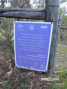
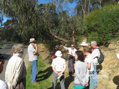
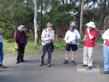
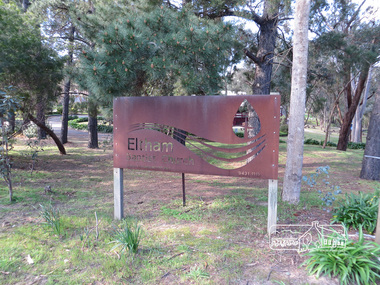
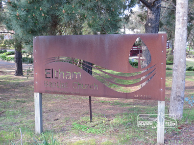
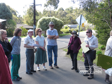
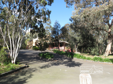
Photograph, Liz Pidgeon, Heritage Excursion; East of Eltham, 6 Sep 2014, 20 May 2017
... south and east. This is a pleasant walk through residential areas and bushland. Along the way we will discuss the early and more recent history of CA 15 as well as local natural history and geology. This walk is about 3.5 km in length and will take 2 to 2.5 hours. It will start at 2pm at the corner of Eucalyptus Road, Pitt Street...south and east. This is a pleasant walk through residential areas and bushland. Along the way we will discuss the early and more recent history of CA 15 as well as local natural history and geology. This walk is about 3.5 km in length and will take 2 to 2.5 hours. It will start at 2pm at the corner of Eucalyptus Road, Pitt Street ...Newsletter No. 218, September 2014 September Excursion - East of Eltham Walk In Newsletter No. 197, March 2011, there was a brief history of Crown Allotment 15 Section 5 Parish of Nillumbik (CA 15) a parcel of land of a quarter of a square mile extending from Eucalyptus Road to Reynolds Road at the eastern extremity of Eltham. From the 1940s it was known as Stokes orchard. In later years it has been subdivided for residential purposes but leaving significant areas as power line and water supply reserves and bushland reserves that are habitat for the threatened For our excursion on 6th September we intend to walk through CA 15 to a bushland reserve east of Reynolds Road. The walk will traverse the boundary between suburban Eltham and the non-urban areas to the south and east. This is a pleasant walk through residential areas and bushland. Along the way we will discuss the early and more recent history of CA 15 as well as local natural history and geology. This walk is about 3.5 km in length and will take 2 to 2.5 hours. It will start at 2pm at the corner of Eucalyptus Road, Pitt Street and Nyora Road.Born Digitaleltham east, eltham district historical society, heritage excursion, activities, nyora road, reynolds road, gum tree road reserve, diosma road, stokes orchard, eucalyptus road -
 Eltham District Historical Society Inc
Photograph, Liz Pidgeon, Heritage Excursion; East of Eltham, 6 Sep 2014, 20 May 2017
... south and east. This is a pleasant walk through residential areas and bushland. Along the way we will discuss the early and more recent history of CA 15 as well as local natural history and geology. This walk is about 3.5 km in length and will take 2 to 2.5 hours. It will start at 2pm at the corner of Eucalyptus Road, Pitt Street...south and east. This is a pleasant walk through residential areas and bushland. Along the way we will discuss the early and more recent history of CA 15 as well as local natural history and geology. This walk is about 3.5 km in length and will take 2 to 2.5 hours. It will start at 2pm at the corner of Eucalyptus Road, Pitt Street ...Newsletter No. 218, September 2014 September Excursion - East of Eltham Walk In Newsletter No. 197, March 2011, there was a brief history of Crown Allotment 15 Section 5 Parish of Nillumbik (CA 15) a parcel of land of a quarter of a square mile extending from Eucalyptus Road to Reynolds Road at the eastern extremity of Eltham. From the 1940s it was known as Stokes orchard. In later years it has been subdivided for residential purposes but leaving significant areas as power line and water supply reserves and bushland reserves that are habitat for the threatened For our excursion on 6th September we intend to walk through CA 15 to a bushland reserve east of Reynolds Road. The walk will traverse the boundary between suburban Eltham and the non-urban areas to the south and east. This is a pleasant walk through residential areas and bushland. Along the way we will discuss the early and more recent history of CA 15 as well as local natural history and geology. This walk is about 3.5 km in length and will take 2 to 2.5 hours. It will start at 2pm at the corner of Eucalyptus Road, Pitt Street and Nyora Road.Born Digitaleltham east, eltham district historical society, heritage excursion, activities, nyora road, reynolds road, gum tree road reserve, diosma road, stokes orchard, eucalyptus road