Showing 18 items matching "railway components"
-
 Wodonga & District Historical Society Inc
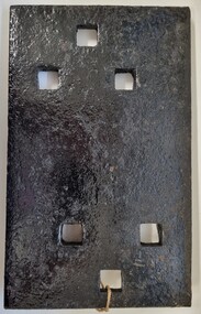
Functional object - Rail fish plate from Cudgewa Line, 1930 - 1960s
... ...Railway components...Victorian Railways Cudgewa rail line Railway components A section of flat plate. These plates were used in pairs to connect the ends of adjacent rails in railway track. ...Cudgewa Line -The Cudgewa railway line opened in stages between 1889 and 1921. The first section from Wodonga to Huon opened on 10 September 1889. It was extended to Bolga on 18 July 1890, Tallangatta on 24 July 1891, Shelley on 13 June 1916 (the highest station in Victoria), Beetomba on 10 April 1919 and Cudgewa on 5 May 1921. The line had 1 in 30 grades and trestle bridges that have been heritage listed. In 1919, the line was used to carry materials for the construction of Hume Weir, and three years later a spur line connecting Ebden to the weir was opened. In the 1960s, Cudgewa became the railhead of materials for the Snowy Mountains Scheme. The last passenger service from Wodonga to Tallangatta ran on 30 September 1961. The turntable and passenger platform at Cudgewa were abolished in 1976. This fish plate came from the rails of the Cudgewa Line at Gordon Roy's hut which was situated behind Perry's Stump Hotel outside Wodonga. The hut was used as an office with the points lever outside to switch trucks to different tracks on the Bandiana and Cudgewa lines.This item is significant as it was part of the railway line to Cudgewa which played an important role in North east Victoria carrying freight during the construction of the Hume Weir and the Snowy Mountains Scheme.A section of flat plate. These plates were used in pairs to connect the ends of adjacent rails in railway track. victorian railways, cudgewa rail line, railway components -
 Flagstaff Hill Maritime Museum and Village
Instrument - Barometer, 1867
... The works employed as many as 350 workers manufacturing a wide range of marine, mining, civil engineering, railway and general manufacturing components including engines and boilers. ...The works employed as many as 350 workers manufacturing a wide range of marine, mining, civil engineering, railway and general manufacturing components including engines and boilers. ...Langlands Company History: Langlands foundry was Melbourne's first foundry and iron shipbuilder established in 1842, only 8 years after the founding of the Victorian colony by two Scottish immigrants, Robert Langlands and Thomas Fulton, who had formed a partnership before emigrating (1813–1859). The business was known as the 'Langlands Foundry Co'. Henry Langlands (1794-1863), left Scotland in 1846 with his wife Christian, née Thoms, and five surviving children to join his brother Robert. By the time he arrived in early January of 1847 the partnership of Robert Langlands and Fulton had dissolved as Fulton had gone off to establish his own works. It was at this time that the two brothers took over ownership of Langlands foundry. Several years later Robert retired and Henry became sole the proprietor. The foundry was originally located on Flinders Lane between King and Spencer streets. Their sole machine tool, when they commenced as a business, was a small slide rest lathe turned by foot. In about 1865 they moved to the south side of the Yarra River, to the Yarra bank near the Spencer Street Bridge and then in about 1886 they moved to Grant Street, South Melbourne. The works employed as many as 350 workers manufacturing a wide range of marine, mining, civil engineering, railway and general manufacturing components including engines and boilers. The foundry prospered despite high wages and the lack of raw materials. It became known for high-quality products that competed successfully with any imported articles. By the time Henry retired, the foundry was one of the largest employers in Victoria and was responsible for casting the first bell and lamp-posts in the colony. The business was carried on by his sons after Henry's death. The company was responsible for fabricating the boiler for the first railway locomotive to operate in Australia, built-in 1854 by Robertson, Martin & Smith for the Melbourne and Hobson's Bay Railway Company. Also in the 1860s, they commenced manufacture of cast iron pipes for the Board of Works, which was then laying the first reticulated water supply system in Melbourne. Langlands was well known for its gold mining equipment, being the first company in Victoria to take up the manufacture of mining machinery, and it played an important role in equipping Victoria's and Australia's first mineral boom in the 1850s and 1860s. Langlands Foundry was an incubator for several engineers including Herbert Austin (1866–1941) who worked as a fitter at Langlands and went on to work on the Wolesely Shearing machine. He also founded the Austin Motor Company in 1905. Around the 1890s Langlands Foundry Co. declined and was bought up by the Austral Otis Co. in about 1893. History for Grimoldi: John Baptist Grimoldi was born in London UK. His Father was Domeneck Grimoldi, who was born in Amsterdam with an Italian Father and Dutch mother. Domeneck was also a scientific instrument maker. John B Grimoldi had served his apprenticeship to his older brother Henry Grimoldi in Brooke Street, Holburn, London and had emigrated from England to Australia to start his own meteorological and scientific instrument makers business at 81 Queens St Melbourne. He operated his business in 1862 until 1883 when it was brought by William Samuel and Charles Frederick, also well known scientific instrument makers who had emigrated to Melbourne in 1875. John Grimoldi became successful and made a number of high quality measuring instruments for the Meteorological Observatory in Melbourne. The barometer was installed at Warrnambool's old jetty and then the Breakwater as part of the Victorian Government's insistence that barometers be placed at all major Victorian ports. This coastal barometer is representative of barometers that were installed through this government scheme that began in 1866. The collecting of meteorological data was an important aspect of the Melbourne Observatory's work from its inception. Just as astronomy had an important practical role to play in navigation, timekeeping and surveying, so the meteorological service provided up to date weather information and forecasts that were essential for shipping and agriculture. As a result, instruments made by the early instrument makers of Australia was of significant importance to the development and safe trading of companies operating during the Victorian colonies early days. The provenance of this artefact is well documented and demonstrates, in particular, the importance of the barometer to the local fishermen and mariners of Warrnambool. This barometer is historically significant for its association with Langlands’ Foundry which pioneered technology in the developing colony by establishing the first ironworks in Melbourne founded in 1842. Also, it is significant for its connection to John B Grimoldi who made the barometer and thermometer housed in the cast iron case. Grimoldi, a successful meteorological and scientific instrument maker, arrived in the colony from England and established his business in 1862 becoming an instrument maker to the Melbourne Observatory. Additional significance is its completeness and for its rarity, as it is believed to be one of only two extant barometers of this type and in 1986 it was moved to Flagstaff Hill Maritime Village as part of its museum collection. Coast Barometer No. 8 is a tall, red painted cast iron pillar containing a vertical combined barometer and thermometer. Half way down in the cast iron framed glass door is a keyhole. Inside is a wooden case containing a mercury barometer at the top with a thermometer attached underneath, each with a separate glass window and a silver coloured metal backing plate. Just below the barometer, on the right-hand side, is a brass disc with a hole for a gauge key in the centre. The barometer has a silvered tin backing plate with a scale, in inches, of "27 to 31" on the right side and includes a Vernier with finer markings, which is set by turning the gauge key. The thermometer has a silvered tin backing plate with a scale on the left side of "30 to 140". Each of the scales has markings showing the units between the numbers.Inscription at the top front of the pillar reads "COAST BAROMETER" Inscribed on the bottom of the pillar is "No 8". and "LANGLANDS BROS & CO ENGINEERS MELBOURNE " The barometer backing plate is inscribed "COAST BAROMETER NO. 8, VICTORIA" and printed on the left of the scale, has "J GRIMOLDI" on the top and left of the scale, inscribed "Maker, MELBOURNE". There is an inscription on the bottom right-hand side of the thermometer scale, just above the 30 mark "FREEZING" Etched into the timber inside the case are the Roman numerals "VIII" (the number 8)flagstaff hill, warrnambool, maritime village, maritime museum, flagstaff hill maritime museum & village, shipwreck coast, great ocean road, warrnambool breakwater, coast barometer, coastal barometer, barometer, weather warning, ports and harbours, fishery barometer, sea coast barometer, austral otis co, coast barometer no. 8, henry grimoldi, henry langlands, john baptist grimoldi, langlands foundry co, meteorological instrument maker, robert langlands, scientific instrument maker, thermometer, thomas fulton -
 Port of Echuca
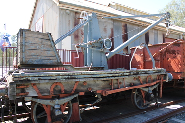
Functional object - Portable Crane K Wagon
... components have been replaced it still retains substantial ironwork dating from 1874 and the 1898 conversion to portable cranes. Wharf Shire of Campaspe Rawlings & Co Melbourne Portable Crane Rollingstock Collection Steam trains K 279 Wooden Flat Portable Crane by Rawlings & Co Melbourne 1874 Functional object Portable Crane K Wagon West Coast Railway Shire of Campaspe ...Built as a wooden flat wagon by Rawlings & Co in Melbourne in 1874. it was altered to a mobile 2 ton crane in 1898. In service in Maryborough for most of its service until February 1974.Actual identity of this unit is not confirmed and is possible it is one of other similar wagon mounted cranes. rebuilt with all timber components replaced at Echuca Wharf c2000 This vehicle is unusual and very significant as even though the timber components have been replaced it still retains substantial ironwork dating from 1874 and the 1898 conversion to portable cranes. Wooden Flat Portable Crane by Rawlings & Co Melbourne 1874 K 279wharf, shire of campaspe, rawlings & co melbourne, portable crane, rollingstock collection, steam trains -
 Port of Echuca
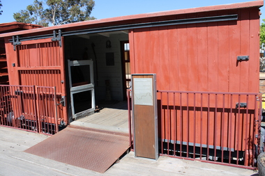
Functional object - Produce Wagon H Class
... railway scene but only remained in their relative use for a short time. It remained in service in an altered form until 1983, by which time the H van had been at Echuca Wharf for 10 years. This van is very significant. It is a good example of the transitional period of rolling stock design, using timber with some steel components ...One of the last designed H Class Box Van, built at the Newport workshops in 1893. It was an important part of the railway scene but only remained in their relative use for a short time. It remained in service in an altered form until 1983, by which time the H van had been at Echuca Wharf for 10 years. This van is very significant. It is a good example of the transitional period of rolling stock design, using timber with some steel components around the turn of the 20th century. The H van In Echuca is the only one with the bar doors still fitted.Vic Railways red 4 wheeled Produce Van with solid timber and a barred door to provide ventilation when carrying fruit and vegetablesH Classwharf, shire of campaspe, newport workshop, barred door, victorian railways, rollingstock collection, steam trains -
 The Beechworth Burke Museum
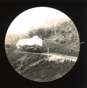
Photograph - Lantern Slide, c1900
... The subsequent positioning of Beechworth on a branch rather than a main line was not considered ideal to achieve these aims, but the Everton-to-Beechworth and Beechworth-to-Yackandandah components of the line cost an average of £7,277 per mile and State Government officials felt the need in the area did not justify the cost of a direct line. The Beechworth Railway...The subsequent positioning of Beechworth on a branch rather than a main line was not considered ideal to achieve these aims, but the Everton-to-Beechworth and Beechworth-to-Yackandandah components of the line cost an average of £7,277 per mile and State Government officials felt the need in the area did not justify the cost of a direct line. The Beechworth Railway ...This slide shows a train proceeding along the Beechworth rail trail in approximately 1900. The rail line to Beechworth was the subject of significant lobbying by local officials such as John Orr and G.B. Kerferd in the 1860s, as it was recognised that the poor quality of roads to Melbourne and Albury hindered trade and formed a barrier to the social development of the town. The subsequent positioning of Beechworth on a branch rather than a main line was not considered ideal to achieve these aims, but the Everton-to-Beechworth and Beechworth-to-Yackandandah components of the line cost an average of £7,277 per mile and State Government officials felt the need in the area did not justify the cost of a direct line. The Beechworth Railway Station was officially opened on the 29th of September 1876 and ran services twice daily to Melbourne, transporting nearly 12,000 passengers and around 6,500 tons of cargo in 1900. It closed in 1976 and is today used as a cycling trail used by locals and promoted as a feature of the area to tourists. Lantern slides, sometimes called 'magic lantern' slides, are glass plates on which an image has been secured for the purpose of projection. Glass slides were etched or hand-painted for this purpose from the Eighteenth Century but the process became more popular and accessible to the public with the development of photographic-emulsion slides used with a 'Magic Lantern' device in the mid-Nineteenth Century. Photographic lantern slides comprise a double-negative emulsion layer (forming a positive image) between thin glass plates that are bound together. A number of processes existed to form and bind the emulsion layer to the base plate, including the albumen, wet plate collodion, gelatine dry plate and Woodburytype techniques. Lantern slides and magic lantern technologies are seen as foundational precursors to the development of modern photography and film-making techniques.This glass slide is significant because it provides insight into Beechworth's social amenities and transport infrastructure in the late Nineteenth Century. It is also an example of an early photographic and film-making technology in use in regional Victoria in the time period.Thin translucent sheet of glass with a circular image printed on the front and framed in a black backing. It is held together by metal strips to secure the edges of the slide.burke museum, beechworth, lantern slide, slide, glass slide, plate, burke museum collection, photograph, monochrome, indigo shire, north-east victoria, rail trail, beechworth rail trail, beechworth station, everton, wangaratta, wodonga, albury, rail transport, cargo transport, g.b. kerferd, john orr, murray to mountains rail trail, cycling, biking, railway -
 Orbost & District Historical Society
black and white photograph, first half 20th century
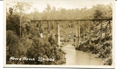
... Railway, and is situated in the middle of the township of Nowa Nowa, crossing a steep-sided and well-timbered creek-valley. This section of the line closed in 1987. This bridge plays a major part in the identity and history of the town of Nowa Nowa, since Boggy Creek’s steep sided valley divides the township into two components. ...This appears to be the Boggy Creek bridge and to have been taken at Nowa Nowa. The Boggy Creek Bridge was built in 1916 as part of the Bairnsdale to Orbost extension to the main Gippsland Railway, and is situated in the middle of the township of Nowa Nowa, crossing a steep-sided and well-timbered creek-valley. This section of the line closed in 1987.This bridge plays a major part in the identity and history of the town of Nowa Nowa, since Boggy Creek’s steep sided valley divides the township into two components. It is part of the East Gippsland Railway line.A black / white photograph / postcard of a tall railway bridge, with concrete pylons in the centre,There is a creek below.on front - bottom left - " NOWA NOWA BRIDGE"boggy-creek-railway-bridge nowa-nowa railway-bridge east-gippsland-railway orbost-bairnsdale-railway -
 Orbost & District Historical Society
black and white photograph, first half 20th century
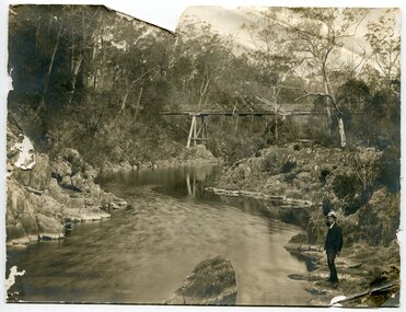
... Railway, and is situated in the middle of the township of Nowa Nowa, crossing a steep-sided and well-timbered creek-valley. This section of the line closed in 1987. This bridge plays a major part in the identity and history of the town of Nowa Nowa, since Boggy Creek’s steep sided valley divides the township into two components. ...This appears to be the Boggy Creek bridge and to have been taken at Nowa Nowa. The Boggy Creek Bridge was built in 1916 as part of the Bairnsdale to Orbost extension to the main Gippsland Railway, and is situated in the middle of the township of Nowa Nowa, crossing a steep-sided and well-timbered creek-valley. This section of the line closed in 1987.This bridge plays a major part in the identity and history of the town of Nowa Nowa, since Boggy Creek’s steep sided valley divides the township into two components. It is part of the East Gippsland Railway line.A black / white photograph of a bridge across a creek. A young man in a suit is standing in the foreground.boggy-creek-bridge-nowa-nowa -
 Orbost & District Historical Society
framed black and white photograph, C1920
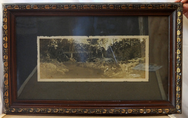
... railway bridge on the East Gippsland line. This bridge plays a major part in the identity and history of the town of Nowa Nowa, since Boggy Creek’s steep sided valley divides the township into two components. ...Boggy Creek Bridge was built in 1916 as part of the Bairnsdale to Orbost extension to the main Gippsland Railway, and is situated in the middle of the township of Nowa Nowa, crossing a steep-sided and well-timbered creek-valley. This section of the line closed in 1987. This item is a pictorial record of the Boggy Creek railway bridge on the East Gippsland line. This bridge plays a major part in the identity and history of the town of Nowa Nowa, since Boggy Creek’s steep sided valley divides the township into two components.A black / white photograph of a bridge across a river in the bush. It is under glass in a brown wooden frame which has gold decorated edges. There appears to be a man sitting on rocks in the right front foreground.on front of photograph - "Nowa Nowa Creek, Gippsland, Victoria, Sears, Copyright"boggy-creek-nowa-nowa east-gippsland-railway bridge-rail -
 Orbost & District Historical Society
photograph / postcard, early 20th century
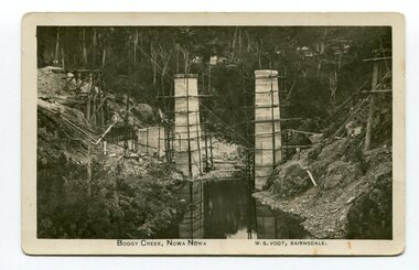
... railway bridge on the East Gippsland line. This bridge plays a major part in the identity and history of the town of Nowa Nowa, since Boggy Creek’s steep sided valley divides the township into two components. boggy-creek-bridge vogt-w.s. railway-bridges east-gippsland-railway railway-construction train on front of postcard - caption - " Boggy Creek, Nowa Nowa, W.S. ...Boggy Creek Bridge was built in 1916 as part of the Bairnsdale to Orbost extension to the main Gippsland Railway, and is situated in the middle of the township of Nowa Nowa, crossing a steep-sided and well-timbered creek-valley. This section of the line closed in 1987.This item is a pictorial record of the construction of the Boggy Creek railway bridge on the East Gippsland line. This bridge plays a major part in the identity and history of the town of Nowa Nowa, since Boggy Creek’s steep sided valley divides the township into two components. A black / white photograph on a postcard showing the construction of a railway bridge across a creek. The end pylons are evident and there is scaffolding on both sides of the creek. Two copies of a black / white photograph showing the construction of a railway bridge across a cree. The end pylons are evident and there is scaffolding on both sides of the creek. There is a steam train on the rail track.on front of postcard - caption - " Boggy Creek, Nowa Nowa, W.S. Vogt, Bairnsdale"boggy-creek-bridge vogt-w.s. railway-bridges east-gippsland-railway railway-construction train -
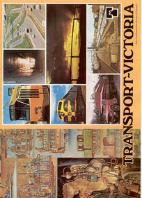 Ballarat Tramway Museum
Book, Ministry of Transport, "Transport - Victoria", c1980
... Sixteen page, full cover book titled "Transport - Victoria", published by the Ministry of Transport c1980 - Robert Maclellan as Minister soon after the establishment of the Ministry, combining VicRail, MMTB, TRB, CRB, MURLA, Westgate Bridge Authority, and the Railway Construction Board. Gives details of each of the component authorities, maps, their work, with the part of the Spencer St Station History of Transport Mural on the front cover....Ballarat Tramway Museum South Gardens Reserve Wendouree Parade Ballarat Ballarat goldfields Trams tramways MMTB VR VicRail CRB Transport Regulation Board Map Sixteen page, full cover book titled "Transport - Victoria", published by the Ministry of Transport c1980 - Robert Maclellan as Minister soon after the establishment of the Ministry, combining VicRail, MMTB, TRB, CRB, MURLA, Westgate Bridge Authority, and the Railway Construction Board. Gives details of each of the component authorities, maps, their work, with the part of the Spencer St Station History of Transport Mural on the front cover. ...Sixteen page, full cover book titled "Transport - Victoria", published by the Ministry of Transport c1980 - Robert Maclellan as Minister soon after the establishment of the Ministry, combining VicRail, MMTB, TRB, CRB, MURLA, Westgate Bridge Authority, and the Railway Construction Board. Gives details of each of the component authorities, maps, their work, with the part of the Spencer St Station History of Transport Mural on the front cover.trams, tramways, mmtb, vr, vicrail, crb, transport regulation board, map -
 Croydon Conservation Society Inc.
Archive, Cheong Wildflower Sanctuary Croydon - Archive Records - Parent Record
... It provides habitat for a range of possums, lizards, birds and bats, as well as a range of invertebrates, and is an important component of the Wicklow Ridgeline and Belgrave Railway habitat corridors....It provides habitat for a range of possums, lizards, birds and bats, as well as a range of invertebrates, and is an important component of the Wicklow Ridgeline and Belgrave Railway habitat corridors. ...Originally donated to the public by the Cheong Family, the Cheong Wildflower Sanctuary supports 1.2 hectares of Valley Heathy Forest vegetation and a large range of locally very rare plant species. It provides habitat for a range of possums, lizards, birds and bats, as well as a range of invertebrates, and is an important component of the Wicklow Ridgeline and Belgrave Railway habitat corridors. -
 City of Melbourne Libraries
Photograph, Bull, Hugh Jones, 1897-1993, Princes Bridge Centenary pylons under construction
... Railway Bridge. The Centenary pylons are no longer in place, but today this intersection still plays a major part in Melbourne’s daily life: people still meet “under the clocks” at Flinders Street station, and the route in and out of the city along St Kilda Road is often a feature of parades such as Moomba, the Grand Final Parade, and of course the Anzac Day Parade which commences at the Princes Bridge intersection and finishes at the Shrine of Remembrance. There are many tram routes, which cross the Bridge, and it directs pedestrians towards the Arts Precinct, the various components...Railway Bridge. The Centenary pylons are no longer in place, but today this intersection still plays a major part in Melbourne’s daily life: people still meet “under the clocks” at Flinders Street station, and the route in and out of the city along St Kilda Road is often a feature of parades such as Moomba, the Grand Final Parade, and of course the Anzac Day Parade which commences at the Princes Bridge intersection and finishes at the Shrine of Remembrance. There are many tram routes, which cross the Bridge, and it directs pedestrians towards the Arts Precinct, the various components ...Princes Bridge Centenary pylons under construction Possibly taken from Young and Jacksons Hotel (formerly Princes Bridge Hotel) on the corner of Flinders and Swanston streets, Flinders Street Station’s clocks and main entrance dominate, along with its distinctive copper dome and decorative façade. The time on the main clock is 1.40pm, and the sign underneath, reflecting Melbourne’s upcoming Centenary reads, “We must accommodate our Centenary visitors! Citizens! Do your share by taking paying guests.” At left is the original Princes Bridge Station, today the site of Federation Square. The riverside tram terminus advertises a Café/Tobacconist/Refreshment Room selling cigars & cigarettes, fountain drinks & confectionery, and in smaller text: “Leave your boot repairs here”. Nearly everyone is dressed in dark suits, coats and hats. The footpaths are wide and there are no traffic lights. The roadway stretches towards the Shrine of Remembrance, not yet dedicated but very dominant on the skyline. Government House is clearly visible across the wide parkland that would come to be known as Kings Domain and that is an area of deep importance to the people of the Eastern Kulin. Originally, Birrarung was part of a network of swamps and lagoons linked to the course of the river. From 1896, Public Works Department engineer Carlo Catani, oversaw a new channel to straighten the river and the swamps and lagoons were filled with spoil from the channel works. From the same vantage point today, only the top of the tower of Government House would be visible. The photo captures the pylons along Princes Bridge, mid-construction and being installed to mark Melbourne’s Centenary. The pylons were not without controversy. Both The Argus and The Age bemoaned them for being “made almost entirely of imported softwood timber”, denying work to native hardwood timber workers and sawmillers, and leading visitors to think Australia did not have its own exceptional native hardwoods. The pylons were also variously described in their incomplete state, as unimaginative and resembling an oilfield. Published: The Age 5 September 1934 Featured in "Newsworthy: Melbourne in photographs 1933-1936" exhibition at East Melbourne Library, October to December 2023. Exhibition caption by project volunteer, Louise McKenzie Photographer notations on slide: "Pylons + St Kilda Rd C57" Published: Age (Melbourne, Vic. : 1854 - 1954), Wednesday 5 September 1934, page 11 Published title: DECORATIONS -- THEN AND NOW. Published caption: "Although not completed yet, some impression of the effect of the decorations on Princes-bridge may be obtained from the first picture which shows the majestic sweep of St Kilda road with the Shrine of Remembrance and Government House dominating the horizon. The area to the left of St. Kilda-road and in front of Government House is portion of the area which it is proposed to call the King's Domain, which extends to Domain-road and Anderson-street..." Description: East-facing, elevated view of Flinders Street Station and Princes Bridge, featuring partially completed pylons erected for Melbourne's Centenary celebrations. The Shrine of Remembrance and Government House can be seen in the distance. In the foreground are trams, cars and trucks, pedestrians, Batman Avenue tram terminus and refreshment rooms. Signage on Flinders Street Station encourages citizens to accommodate Centenary visitors. The Melbourne Centenary was held 1934-35 in celebration John Batman's proclamation that Melbourne "the place for a village". Centenary events included a visit by Prince Henry, Duke of Gloucester. A Centenary Cake measuring 50 feet in height and ten tons in weight was cut into 250,000 pieces and sold at 1 shilling per piece for charity. Spectacular floodlighting of city landmarks, the creation of the Pioneer Women's Memorial Garden, and the MacRobertson Air Race from London, were other notable activities. Research by project volunteer, Louise McKenzie: The photo in The Age collage of 5 September 1934 has a slightly cropped foreground. The original photo has been taken from an elevated vantage point, most probably the roof of the Nicholas Building on the corner of Flinders and Swanston streets. The right foreground is dominated by the main “clocks” entrance to Flinders Street Station, showing its distinctive copper dome and decorative façade. The time on the main clock is 1.40 pm. The main sign on the front of the Station reads, "We Must Accommodate our Centenary Visitors! Citizens! Do your share by taking paying guests. Write to The Official Centenary Accommodation Bureau, 436 Collins St. City. Tel M 4671”. Another sign at eye level at the main entrance says: “Cheap Trips on Sundays”. The sign on the end of the roof along the eastern side of the station reads, “The Babies Need Your Help! Support Broadmeadows Foundling Hospital Appeal. July and August”. Run by the Sisters of St Joseph of the Sacred Heart, St Joseph’s Foundling Hospital was a purpose built infants’ home for up to 300 babies, plus accommodation for expectant mothers, mainly single women. In the early 1930s, the department (Victorian Children’s Welfare Department) contracted St Joseph’s Foundling Hospital to care for an additional 60 infant state wards, and up to 175 non wards at any given time. In 1931 it also operated a mothercraft training school. The centre foreground shows the commencement of Princes Bridge. Beneath the left side of the bridge was the site of the original Princes Bridge Station, by this time incorporated into Flinders Street Station, and today the area is the site of Federation Square. It was linked to Flinders Street station by the railway tracks that ran underneath the northern approach to the bridge. This photo shows a tram terminus which has a Café/Tobacconist/Refreshment Room, selling cigars & cigarettes, fountain drinks & confectionary, and a sign: Leave your boot repairs here. In the foreground is a wide roadway running south/north, comprising two vehicle lanes each heading north/south, and a central section containing two sets of tram tracks. There are cars, buses and delivery vans on the roadway. The trams visible are Glen Iris (Route No. 6; tram no. 448), Toorak (Route No. 8, tram no. 333), ? (No. 7), ? (No. 1), and ? (No. 2A). The footpaths are extremely wide. There is a square newspaper/magazine stand on the eastern side footpath. And also a “Ferry” sign. There are no traffic lights, but a policeman is visible on the roadway. There are pedestrians – men, women, children, a porter with trolley, women with prams. Clothing comprises dark suits, coats and hats for nearly everyone. There are double headed “Collins Street” lights along the side of the roadway, and along the northern riverbank. The roadway in the foreground is an extension of Swanston Street, which becomes Princes Bridge, then St Kilda Road, stretching towards the Shrine of Remembrance, and diverting past it. The Shrine had not yet been officially dedicated, and looks very white and dominant on the skyline. On the LHS of St Kilda Road, Government House is clearly visible across the wide parkland to be known as Kings Domain. The Kings Domain area is important to the people of the Eastern Kulin nation, and also has historical importance for its association with the early settlement of Melbourne and the foundation of British colonial administration in Victoria. On the southern side of the Yarra River (Birrarung) an historic rowing boathouse is visible, located adjacent to the Alexandra Gardens. Originally Birrarung was part of a network of swamps and lagoons linked to the course of the river. From 1896, under the guidance of engineer Carlo Catani* a new channel to straighten the river was created and the swamps and lagoons were filled with spoil from the channel works. The gardens were then created and completed in time for a Royal visit by the Duke of York in May 1901. The gardens are named after Alexandra of Denmark, the wife of King Edward VII. Both these areas, plus the Royal Botanic Gardens Victoria, Shrine of Remembrance Reserve, Sidney Myer Music Bowl, Government House, and the Queen Victoria Gardens together form the Domain Parklands. The extent of the subsequent plantings is evident today, where from the same vantage point only the top of the tower of Government House would be visible. *Catani was born in Florence in 1852, but after arriving in Melbourne worked as a civil engineer for the Victorian Government. His last major project was the reclamation of the foreshore of St Kilda, envisaged in the style of a European resort, complete with a split level esplanade, bathing pavilions, dance halls, amusements and a French-Italian style of landscape complete with palms. The gardens at the end of Fitzroy Street, St Kilda, now bear his name. The historic boathouse visible across the Yarra is another glimpse into Melbourne’s past. “Boathouse Row” comprises 7 amateur rowing clubs, the first established in 1859 (Melbourne University Boat Club). Other Clubs were Richmond, Melbourne, Banks, Melbourne Grammar School, Yarra Yarra and Mercantile. South of the river and west of the bridge is an area today developed into the Melbourne arts precinct of Hamer Hall and the Arts Centre. But at this time it was the home of Wirths Olympia Circus, which comprised Wirths Pleasure Park (an amusement park), a 5,000 seat auditorium – Hippodrome, a roller skating rink, a glaciarium, a cinema, and the Green Mill Dance Hall. Dog shows were also held at Olympia. The Green Mill Dance Hall closed in 1950, and the remainder of the Wirth buildings on site were destroyed by fire in December 1953. The feature of the photo is the pylons erected along Princes Bridge to mark Melbourne’s Centenary in 1934. The sixteen plastered pylons were designed by Roy Prentice, the second person to qualify as an architect at The University of Melbourne’s Bachelor of Architecture degree, in 1933, aged 27. Simon Reeves in his article marking the 100th birthday of Roy Prentice on 20 June 2006 reports that the State Electricity Commission sponsored this work, and the Argus reported that “… the pylons were “illuminated from within to give the effect of soft radiance”. Australia Home Beautiful 1 Oct 1934 reports in a very detailed and comprehensive article: The 10 taller pylons, including flagpole, were 48 ft, with a base of 8 ft. Timber-framed and faced with fibrous plaster and galvanised sheet iron, each structure was securely bolted to a concrete foundation three feet in depth. Panels of glass let into the shaft of each pylon were indirectly lit by 40, 100 watt lamps, and the upper bank of internal lamps were dyed so as to flood the panels with a deep red light. The decorative painted shields and flagpoles/pennants were illuminated by three 200 watt projectors concealed in the roof of each pylon, and were part of an electric night light decoration scheme involving 28 miles of wire to supply more than 20,000 lights. An article in the Argus on 18 October 1934 provided minute detail of the lighting erected in Melbourne for the Centenary, converting it “… into a coloured fairyland by night.” The estimated cost of 10 pounds per hour the lights were on. The display included 800 standard light poles 30 feet high which were tiered with electric bulbs concealed in inverted cones, 138 specially designed “Venetian poles” draped in flags trophies and streamers. The streets included in the electric night light decoration scheme were Bourke Street from Spring to William, the entire length of Collins Street, Flinders Street from Elizabeth to Spring, Lonsdale Street from Elizabeth to Swanston, Swanston and Elizabeth Streets from Flinders to Lonsdale, and parts of Springs and Spencer Streets. Together with the Princes Bridge pylons, approximately 28 miles of wire was required to supply power to the more than 20,000 lights. And that is just in the city of Melbourne. It was estimated the same amount of lighting was duplicated among other local councils. The pylons were not without controversy. The Argus on 28 August 1934 in an article headed “Imported Timber in Pylons” reported that the Princes Bridge pylons are “made almost entirely of imported softwood timber”, and have therefore denied work to native hardwood timber workers and sawmillers. The same day the Melbourne Age ran a similar story, bemoaning the fact that foreign oregon had been used which may lead tourists to think Australia did not have its own exceptional native hardwoods. A Camberwell City Councillor described the pylons as unimaginative, and the Herald reported that skeletons of pylons for the Centenary decorations in their present form led the area to resemble an oilfield! The Yarra River and Princes Bridge have long been a focal point of Melbourne life. In the early days of European settlement in Melbourne a rope-hauled punt carried people across the Yarra River. A surge in population and increased shipping traffic created a need for a bridge. There was difficulty in agreeing on a suitable site for the bridge (options were crossing at Elizabeth, Swanston, Queen or Market Streets), but the NSW Government favoured Swanston Street and the Melbourne Town Council decided on a temporary bridge across the Yarra spanning from the foot of Swanston Street. This first bridge was a single span timber toll bridge designed by Scottish born bridge designer David Lennox, and completed in 1845. It was 120 feet long, had a roadway of 17 feet wide, and a footpath on one side of 4 feet. It was leased to the Melbourne Bridge Company in the name of Robert A Balbirnie. The tollhouse was on the north side of the river and the toll keeper, Patrick Doherty, was credited with saving nine lives during the four years he was in charge of the toll station. The second bridge was stone (completed 1850), and named Prince’s Bridge after the HRH Prince of Wales, later Edward VII. It was designed with an elliptical single arc and an exceedingly small rise in proportion to the span. However, this design created an obstacle for flood waters, and together with Melbourne’s increasing population it was quickly apparent that a new bridge was required. At its opening on 15 November 1850 coincided with the imminent declaration of Victoria as a separate colony, it provided a moment of great celebration for Melbournians and “The opening ceremony was described as the grandest processional display witnessed in the colony.” (ToMelbourne.com.au) Princes Bridge in its present form, as depicted in this photograph, was designed by Jenkins, D’Ebro and Grainger, and constructed in 1886-88 by David Munro. John Grainger (father of Australian composer Percy Grainger) did the majority of the design work for the bridge. The structure was to have three arches each 96 feet wide measured across the river, and the banks on both sides were raised to allow more space for floodwater to flow. St Kilda Road was originally many feet below the current level. The bridge is of architectural significance for its substantial size, giant half columns, extensive use of wrought and cast iron, decorative elements (cast-iron lamps) and the skilled stonemasonry in the construction of the abutments and piers. Its main design features are similar to those of Blackfriars Bridge in London (1870). The bluestones were quarried from Footscray, the Malmsbury stones were from quarries at Kyneton, and the granite from Harcourt. The cost was met by the State of Victoria, City of Melbourne, and six out of seven of its municipalities, and their coats of arms feature on the bridge. The building of the bridge reflected the boom period of Melbourne, including the Victorian gold rush 1851- late 1860s, and its contractor, David Munro, was also responsible for the construction of Queens Bridge and Sandridge Railway Bridge. The Centenary pylons are no longer in place, but today this intersection still plays a major part in Melbourne’s daily life: people still meet “under the clocks” at Flinders Street station, and the route in and out of the city along St Kilda Road is often a feature of parades such as Moomba, the Grand Final Parade, and of course the Anzac Day Parade which commences at the Princes Bridge intersection and finishes at the Shrine of Remembrance. There are many tram routes, which cross the Bridge, and it directs pedestrians towards the Arts Precinct, the various components of Domain Park, plus the Southbank restaurant and rowing precincts. Even though this is a street scene, it feels very intimate; the viewer is instantly immersed in the activity of a Melbourne afternoon, looking down St Kilda Road from a viewpoint near today’s Federation Square. References: DECORATIONS -- THEN AND NOW. (1934, September 5). The Age (Melbourne, Vic. : 1854 - 1954), p. 11. Retrieved September 21, 2023, from http://nla.gov.au/nla.news-article205880269 'Flinders Street railway station', Wikipedia, https://en.wikipedia.org/wiki/Flinders_Street_railway_station 'St Joseph’s Foundling Hospital (1901-75)', Finding Records, Department of Health and Human Services, State of Victoria, https://www.findingrecords.dhhs.vic.gov.au/collectionresultspage/St-JosephsFoundling-Hospital-Babies-Home#departmental-administration 'Alexandra Gardens', City of Melbourne, https://www.melbourne.vic.gov.au/community/parks-open-spaces/major-parks-gardens/Pages/alexandra-gardens.aspx 'Wirths Circus', Wikipedia, https://en.wikipedia.org/wiki/Wirth's_Circus 'Roy Prentice: Centenary Architect', Built Heritage Pty Ltd, Simon Reeves, https://www.builtheritage.com.au/downloads/prentice.pdf 'Princes Bridge', Heritage Council Victoria, https://vhd.heritagecouncil.vic.gov.au/places/817 PORT PHILLIP. (1846, April 1). The Sydney Morning Herald (NSW : 1842 - 1954), p. 3. Retrieved September 21, 2023, from http://nla.gov.au/nla.news-article12886251 'Edward VII', Wikipedia, https://en.wikipedia.org/wiki/Edward_VII 'Princes Bridge', ToMelbourne.com, https://tomelbourne.com.au/princes-bridge/ 'Princes Bridge', eMelbourne, https://www.emelbourne.net.au/biogs/EM01189b.htm 'Princes Bridge', Australia for everyone, http://australiaforeveryone.com.au/files/melbourne/princes-bridge.html 'Victorian gold rush', Wikipedia, https://en.wikipedia.org/wiki/Victorian_gold_rush IMPORTED TIMBER IN PYLONS (1934, August 28). The Argus (Melbourne, Vic. : 1848 - 1957), p. 9. Retrieved September 21, 2023, from http://nla.gov.au/nla.news-article10952507 Princes-Bridge Pylons. (1934, August 28). The Age (Melbourne, Vic. : 1854 - 1954), p. 7. Retrieved September 21, 2023, from http://nla.gov.au/nla.news-article205532235 Pylons Appear Near Princes Bridge (1934, August 18). The Herald (Melbourne, Vic. : 1861 - 1954), p. 1. Retrieved September 21, 2023, from http://nla.gov.au/nla.news-article243104375 PRINCES-BRIDGE PYLONS. (1934, September 20). The Age (Melbourne, Vic. : 1854 - 1954), p. 10. Retrieved September 21, 2023, from http://nla.gov.au/nla.news-article205873535 28 Miles of Wire (1934, October 18). The Argus (Melbourne, Vic. : 1848 - 1957), p. 1 (The Junior Argus). Retrieved September 21, 2023, from http://nla.gov.au/nla.news-article10977836 'Historical references for Boathouse Row, Melbourne', http://boathouserowmelbourne.com.au/history/ 'ITALIAN DELEGATION TO HONOUR CARLO CATANI, DESIGNER OF THE ST KILDA FORESHORE, St Kilda Historical Society, 2001, https://web.archive.org/web/20070928061938/http://www.skhs.org.au/~SKHSarticles/articles/Carlo_Catani.html# HISTORY IN LIGHTS (1934, July 12). The Herald (Melbourne, Vic. : 1861 - 1954), p. 16. Retrieved September 21, 2023, from http://nla.gov.au/nla.news-article243172436 'Dressing Melbourne for the Duke', The Australian home beautiful: a journal for the home builder. Vol 12 No. 10 (1 October 1934), page 21, 58. Retrieved September 14, 2023, from http://nla.gov.au/nla.obj-2950922209Photographer notations on slide: "Pylons + St Kilda Rd C57".centenaries, bridges, lighting, flinders street railway station -
 City of Melbourne Libraries
Photograph (item), Bull, Hugh Jones, 1897-1993, Unloading timber at Victoria Dock, 1933
... component of Melbourne’s port system. In 1892 the West Melbourne Dock (later Victoria Dock) was opened, downstream and immediately west of the Spencer Street railway shunting yards. ...component of Melbourne’s port system. In 1892 the West Melbourne Dock (later Victoria Dock) was opened, downstream and immediately west of the Spencer Street railway shunting yards. ...Photographer notations on slide: "Unloading Timber at Wharves 1933 Age B5" Published: Age (Melbourne, Vic.: 1854- ), Tuesday 15 August 1933 MAHOGANY FROM MANILA. (1933, August 15). The Age (Melbourne, Vic. : 1854 - 1954), p. 11. Retrieved January 16, 2026, from http://nla.gov.au/nla.news-article204377024 Published title: MAHOGANY FROM MANILA Published Caption: Age Tue 15 Aug 1933 Caption: Unloading Mahogany Logs brought from Manila, Philippine Islands, by the steamer Taiping, which berthed yesterday at Victoria Dock. The vessel discharged twenty logs, each weighing three tons, the first shipment of this type of timber landed in Melbourne. Research by Project Volunteer, Louise McKenzie: This photograph in many ways epitomises Melbourne in the 1930s. It is a time of enormous growth, development and change. But before delving into that, the photo itself is very powerful. The huge mahogany logs being unloaded appear to be so heavy that the ship itself seems to list to port as they are craned over the side. They are being levered into a cart to which two large and sturdy Clydesdale horses are hitched. In contrast to the traditional horses, the wharf is crisscrossed with modern railway tracks. Unloading is both mechanical and manual, and the scene is one of intense interest to a young boy bystander. The ship appears to be squat and solid, but the whole image also gives a feeling of movement and intensity. The mahogany being delivered to Melbourne would be intended for high quality furniture. In the 1930s Australia actually had a growing timber industry, but much of the eucalyptus wood was being utilised for mass produced furniture, and much of this furniture would then have had a veneer applied to it. The fact that it was economic to import this timber from the “Philippine Islands” – not a traditional trading market for Australia – reflects a Victorian economy that was strong enough to support a growing demand for good quality furniture Mahogany was described as a classic, strong hardwood, often used for dark opulent furniture. In the 1930s the importation of timber from Manila (Philippines) to Australia was a notable trade, particularly in Philippine Lauan (often referred to as Philippine Mahogany), which was used as a cheaper alternative to other hardwoods. 1930s furniture, dominated by the art deco style, used a mix of luxurious exotic woods like mahogany, macassar and ebony for high-end pieces, often veneered over less expensive woods such as walnut, birch and poplar, and with plywood, chrome and lacquer also popular for more practical, streamlined designs during the Depression era. By the mid 1930s timber mills were being relocated away from the immediate dock area, but the fact that these logs were being transported by horse-drawn cart implies that the load would not have had to be taken too far for milling. 1885 the Melbourne Harbour Trust Commissioners had decided that land in or near the city was far too valuable to be used as timber yards. Furthermore, large stacks of timber posed a fire risk. The Trust asked the Victorian Government to reserve a site on the east side of the Yarra River opposite Yarraville and Spotswood. Here, in 1889, the Trust began building six jetties and a wharf specifically for the landing of timber. Clydesdale horses were initially brought to Victoria from Tasmania in the 1830s, and with the 1850s gold rush they were imported direct from Scotland. Melbourne was from its earliest years an important centre of horse-breeding from both imported and colonial-bred stock, providing the well-built draught horse for pulling heavily loaded wagons, the harness horse for delivery work and drawing coaches, and the saddle-horse used for riding. Stud breeding facilities were advertised from the early 1840s. By the 1870s the horse export trade was thriving, and the Port of Melbourne was the country's busiest exporter of horses to Indian, Asian and New Zealand markets. Kirk's Melbourne Horse and Carriage Bazaar in Bourke Street first advertised for business in 1840, and by the 1850s Bourke Street West was famed for its horse bazaars and saleyards. The Victorian Clydesdale Horse Society reports that Clydesdale working horses were a vital part of Melbourne's infrastructure and agricultural industry in the 1930s, when they reached the peak of their popularity despite the increasing competition from mechanization. Their main roles and usage at this time were: • City Delivery: Clydesdales were a common sight for metropolitan deliveries, particularly for breweries (such as Carlton & United Breweries), milk runs, and bread deliveries. • Industrial Work: They were heavily used for hauling cargo at the docks, in construction, and at specialized sites like the Truganina Explosives Reserve, where they pulled wagons. • Agriculture: In surrounding rural areas, they were the primary power source for ploughing and agricultural machinery. • Specialization: By the 1930s, the Clydesdale was smaller and more compact than the Shire or Percheron breeds, making them ideal for navigation in urban environments. After the 1930s their numbers decreased due to the onset of WWI and mechanisation. Wartime petrol rationing led to a brief revival for the working horse, as suburban tradesmen, now used to motor delivery, took their old jinkers out of mothballs. By 1947, however, only 1.5% of city traffic was horse-drawn. In 1952 the large horse cartage company A. Kellet Pty Ltd sold its 250 horses and converted its Richmond stables to storage. In the 1950s at Station and Princes piers, wharf labourers refused to work with the six draught horses still being used to haul trolleys and which were soon superseded by the fork lift, semi-trailer and mobile crane. Where carefully trained horses had once shunted trains in city goods yards, a few hundred a week were now being killed at the abattoirs for pet and human consumption. The last MCC dray horse was withdrawn from service in 1958, but some of the few remaining working animals are used by the mounted police for crowd control at demonstrations and football games. The death knell had also sounded for the associated trades of farrier, saddler and blacksmith. Our photo, therefore, showing the wharf with both the haulage Clydesdales and the rail lines, is a strong visual summary of the social and economic changes experienced in Victoria in the 1930s and on towards the 1950s. Our photo is located at Victoria Dock (also known as Victoria Harbour) which is still an active component of Melbourne’s port system. In 1892 the West Melbourne Dock (later Victoria Dock) was opened, downstream and immediately west of the Spencer Street railway shunting yards. It contained a swing basin for ships, replacing the one which had been provided on the south side of the river, later to be the Duke and Orr dry dock, west of the Charles Grimes Bridge. Further west was the South Wharf along the river bank. The history of Victoria Dock is extremely well described by Ashley Smith in his 2 March 2022 article in Docklands News, and its accompanying aerial photo of the Dock taken in 1934. He writes: "In the early 1930s Victoria Dock was one of the biggest sites for trade and export in Melbourne. A constant queue of ships sailed in, unloaded their cargo, recharged and reloaded, then left for the next port. Around the time this photo was taken (found in a 1934 photo book), the trapezium-shaped basin had been through some changes since its construction in the 1890s. The 497-metre-long Central Pier, finished in 1919, now featured six sheds to house the ever-increasing volume of cargo. The entrance had also been widened in the 1920s to allow better access. Some of the berths featured three-ton jib electric cranes to help with loading cargo and a rail network connected to the State Railway service. By the time construction was completed, the dock was 39 hectares and hailed as the second-largest dock in the world (behind Cavendish Dock, Barrow-in-Furness). To further save costs, excavations were dug to a more reasonable seven metres below low water, instead of British engineer Sir John Coode’s recommended 8.3 metres. Even then, the costs were still around £900,000. It was envisaged, with the extra wharfage, that around thirty 90-metre ships could berth inside. On March 22, 1892, Victoria Dock was opened by Victoria’s Governor, the Earl of Hopetoun (later Australia’s first Governor-General) who opened the sluice to let the Yarra in. It took six days to fill the basin with The Leader newspaper estimating that it would take another six months to completely fill (March 26, 1892). In the end, it took nearly a year before the first ship was allowed to enter on February 20, 1893, when the steamer Hubbuck sailed in to unload 1200 tonnes of cargo in 15 hours. The Argus (February 23, 1893) reported that the ship’s captain, J. R. Brodie, called the Yarra “better than the Thames”, and compared Victoria Dock favourably to the Albert Dock (Liverpool)." This would be a good time to move our focus on to the Taiping, which is the transporter of these giant mahogany logs. The Taiping was a steel-hulled, single-screw passenger-cargo Chinese steamer, which today has the dubious legacy of being involved in a collision headlined as “The Chinese Titanic”. It was constructed by the Hong Kong and Shampoa Dock Company at its facility in Hong Kong, with completion in 1926 for service under the Australia Oriental Line. Her gross register tonnage measured 4,324 tons, reflecting her design for inter-island and coastal trade routes, accommodating both passengers and freight. She operated routes connecting Australian ports with East Asian destinations. As World War II approached, Taiping continued predominantly working the trade routes between China and Australia, until December 1941, when she evacuated women and children from Hong Kong to Manila just before Japanese forces overran the region. She then safely reached Australia despite enemy air raids. Taiping was then requisitioned by the Royal Navy and repurposed as a victualling stores issuing ship for the Eastern Fleet, supporting logistical needs in the Pacific and Indian oceans. Returned to the Australian Oriental Line in 1947, she underwent refitting and by mid-1948 was chartered to the Shanghai Shipping Company, and modified for greater passenger accommodation – approximately 500 passengers. In 1948/49 the Chinese Civil War took place. The Taiping departed Shanghai on 26 January 1949 as one of the final vessels evacuating civilians from to Keelung Harbour in Taiwan. Reports indicate that the Taiping carried double the rated capacity of passengers i.e. 1000. The ship carried families, military personnel, civilians, carrying personal belongings, gold and valuables in hope of resettlement in Nationalist Taiwan. It also held heavy cargo in the form of silver and gold bullion loaded by the Central Bank of China. Because of the risk of patrols, and to conserve fuel, the Captain took the ship away from the usual open-sea passage, and instead navigated along the coast. He also extinguished navigation lights to avoid detection. Shortly after midnight on 27 January 1949 the Taiping collided with the smaller cargo steamer Chien Yuan in the East China Sea near the Zhoushan Archipelago. The Chien Yuan was also operating in darkness. The subsequent collision was catastrophic. The Chien Yuan sank with in 5 minutes, with the loss of 72 of its 74 crew. The Taiping sustained severe structural compromise from the broadside strike and initially remained afloat, then made a swift descent into the freezing water, with no attempt at an organised evacuation. No formal recovery process was instigated, however a distress signal went out. 32 survivors were picked up by the Australian destroyer HMAS Warramunga (on patrol nearby), a passing US vessel found 2 more, and local Zhoushan fishermen retrieved others. In the end, only 37 people survived. The event is remembered as a poignant moment in the mass migration to Taiwan, with families tragically separated. A memorial to the disaster exists at the Keelung Harbour naval base on Taiwan. With its total of over 1,500 deaths, it constituted one of the worst peacetime maritime losses. It is sometimes referred to as the “Oriental Titanic” because of the similarly large loss of life and speed of demise with the RMS Titanic in 1912. A fictional depiction of this event appears in the John Woo movies “The Crossing (Part 1) (2014), and The Crossing II (2015), known in Chinese as “Taiping Wheel”. The narrative weaves a story around pre-disaster romances and wartime turmoil among passengers, culminating in the ship’s rapid sinking. “The production, a high-budget Sino-Taiwanese-Hong Kong co-effort, portrays the event as a microcosm of the 1940s Sino-Japanese and civil war legacies, though critics noted the melodramatic style prioritizing spectacle over historical precision.” In conclusion, it is nice to return to our photo, and observe the people involved in this moment. The dockworkers are, so typical of the 1930s, dressed in what looks to us like formal clothing – dark suits or coats, white shirts, and black hats. I am particularly drawn to the young boy, bare-headed, arms crossed, and so intent on the unloading process. He too is wearing a white shirt, black trousers and jacket, and black shoes. This is 1933 Melbourne – but the haircut he is sporting is now very “hipster” and modern in 2026 Melbourne. References: MAHOGANY FROM MANILA. (1933, August 15). The Age (Melbourne, Vic. : 1854 - 1954), p. 11. Retrieved January 30, 2026, from http://nla.gov.au/nla.news-article204377024 Wikipedia, Taiping steamer, https://en.wikipedia.org/wiki/Taiping_(steamer) Wikipedia, Victoria Dock, https://en.wikipedia.org/wiki/Victoria_Dock_(Melbourne) Docklands News, Ashley Smith, 2 Mar 2022, https://www.docklandsnews.com.au/victoria-dock/ Living Histories: Heritage Council of Victoria, Jill Barnard, 2008, Jetties and Piers, https://livinghistories.net.au/wp-content/uploads/2015/11/Jetties-ONL-intro_Part-1.pdf eMelbourne, Wharves and Docks, https://www.emelbourne.net.au/biogs/EM01612b.htm Australian Academy of Technological Sciences – Harvesting Wood, https://www.austehc.unimelb.edu.au/tia/225.html Old Treasury Building, On the Water – The Docks, https://tinyurl.com/3wkbk66m Old Treasury Building, On The Road, https://tinyurl.com/dw44yr3t Port of Melbourne, Victorian Places, https://www.victorianplaces.com.au/port-of-melbourne Docklands Heritage Study - Environmental History, https://mvga-prod-files.s3.ap-southeast-4.amazonaws.com/public/2024-05/docklands-heritage-review-thematic-environmental-history-1991.pdf eMelbourne, Horses, https://www.emelbourne.net.au/biogs/EM00723b.htm Victorian Clydesdale Horse Society, https://www.clydesdalesvic.org.au/history The Crossing, https://letterboxd.com/film/the-crossing-i/Photographer notations on slide: "Unloading Timber at Wharves 1933 Age B5"ships, shipping, timber industry, shipwrecks, horses, docks, wharves, 1930-1939, wars, docklands -
 Ballarat Tramway Museum
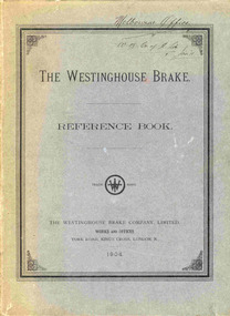
Book, Westinghouse Brake & Saxby Signal Co. Ltd, "The Westinghouse Brake - Reference Book", 1904
... railways. Plat 110E (page 43) has an orange plastic component acting as a brake handle and showing how the various ports and parts interrelated in the valve. ...railways. Plat 110E (page 43) has an orange plastic component acting as a brake handle and showing how the various ports and parts interrelated in the valve. ...One Hundred page book with nine fold out plates tipped in, green card titled "The Westinghouse Brake - Reference Book", published by Westinghouse Brake Co. in 1904. Text has been sewn into sections and then bound into the book. Plate inside front cover, has been printed in colour showing the extent of the use of the Westinghouse brake system that had been adopted on the various railways. Plat 110E (page 43) has an orange plastic component acting as a brake handle and showing how the various ports and parts interrelated in the valve. Inside the back cover are two loose folded sheets, plate 209 and 209A, Improved triple valve and the "Graduating Release Valve", dated August 1905. Covers compressed air brake systems on railway trains, showing how they are designed, operated, parts listing and has a number of pasted in erratum in the book. "Colin Rutledge" stamped on top of page 1 and inside front cover. On cover written in black ink "Melbourne Office, WB Co. of A, Jan '11"trams, tramways, westinghouse, railway brakes, equipment, compressors, carriages -
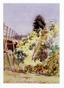 Nillumbik Shire Council
Painting: Walter WITHERS (b.1854 Warwickshire, UK — d.1914 Eltham, Aus), Trestle Bridge, Eltham, c.1903-10
... Railway that was then planned to continue much further up the valley towards Kinglake. This bridge is situated in attractive river-valley parkland amidst the tall and spreading manna gums and candlebarks of the Diamond Creek Valley. The Alistair Knox Park river-valley landscape, of which the timber trestle bridge is an important visual component...Railway that was then planned to continue much further up the valley towards Kinglake. This bridge is situated in attractive river-valley parkland amidst the tall and spreading manna gums and candlebarks of the Diamond Creek Valley. The Alistair Knox Park river-valley landscape, of which the timber trestle bridge is an important visual component ...Walter Withers was a significant Australian landscape artist and a member of the Heidelberg School of Australian Impressionists. In 1903 Withers bought 'Southernwood', a house on 2½ acres (1 ha) at Eltham, to which he added a studio. Because of ill health, he lived during the week at his studio in Oxford Chambers, Melbourne, and on weekends and holidays with his family at Eltham until his death in 1914. The Eltham rail bridge is a unique and valuable historic relic of an earlier steam locomotive transport era in the Diamond Creek Valley and has long formed an important part of a magnificent Eltham landscape. When built in 1902 it was close to the terminus point of the Heidelberg-Eltham rail extension, on the route of the proposed Diamond Valley Railway that was then planned to continue much further up the valley towards Kinglake. This bridge is situated in attractive river-valley parkland amidst the tall and spreading manna gums and candlebarks of the Diamond Creek Valley. The Alistair Knox Park river-valley landscape, of which the timber trestle bridge is an important visual component, has been classified by the National Trust. Large manna gum and candlebark trees adorn the adjacent creek banks, and historic Shillinglaw Cottage is also part of this much-prized Eltham landscape. Eltham is home to a historic wooden railway trestle bridge. Mainly of timber-pier and timber-beam construction, but varied by a few longer steel-joists spans on timber piers at the main stream channel, this substantial bridge has almost two hundred metres of timber deck. Built in 1902, it is the only railway bridge of predominantly timber construction that is still in regular use as an integral part of Melbourne's metropolitan electric railway network and one of extremely few timber rail bridges in the State that still carry trains. Apart from its important continuing social function as a carrier of rail transport for the Hurstbridge line, this impressive bridge and its beautiful parkland environs contribute much to the character of Eltham township and that town's special reputation as an historic centre of environmental and conservation concerns. This section of the Diamond Creek Valley was the subject of a Walter Withers painting in the earliest years of the twentieth century and has strong historic links with our Heidelberg School of painters. Watercolour painting on paper of Eltham's Trestle Bridge in the middle of the day. A small section of the wooden bridge is located to the left of the painting. The focus is predominately on the wattle, manna gum and candlebark trees that is to the right of the bridge. The golden hues typically represent the australian sunlight and landscape. "W.W" in gothic script on the lower right side of the painting. Not dated. withers, eltham, trestle bridge, railway, watercolour -
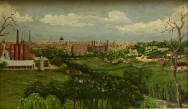 Kew Historical Society Inc
Painting - Panoramic View of Kew and Abbotsford from the garden of Rockingham, Vic Maloney, 1952
... railways agreed to freight for free. Other local support included the work by a team of boys to establish a three-acre vegetable garden within the formal terraced gardens. From the beginning, occupational therapy formed a key component...railways agreed to freight for free. Other local support included the work by a team of boys to establish a three-acre vegetable garden within the formal terraced gardens. From the beginning, occupational therapy formed a key component ...The extensive formal landscaped gardens of Rockingham had been created in the 1860s, and by the 1950s remained bordered to the south by the Barkers Road cutting, and to the north by Blytheswood, the neighbouring Syme family property, By 1940, the Syme family were no longer the occupiers of Rockingham. John Herbert Syme had died in October 1939, and by August the following year, his wife had made the house and garden available, rent free to the Red Cross as a convalescent home for Australian soldiers injured in the Second World War. At the time, the house was described as containing twenty rooms, including a ballroom and a billiards room, with a garden of eight acres overlooking the Yarra. The task of renovating the house to conform to its new function as a convalescent home took a year, finally opening in August 1941. Community support for Rockingham was widespread and included the decision by the National Gallery of Victoria to loan pictures from its collection to decorate the walls. Calls were made for women around Victoria to donate fruit and vegetables from their gardens, which the railways agreed to freight for free. Other local support included the work by a team of boys to establish a three-acre vegetable garden within the formal terraced gardens. From the beginning, occupational therapy formed a key component of the rehabilitation of psychologically injured soldiers. This is confirmed by contemporary newspaper accounts of weaving, ironwork, leatherwork, basketry and gardening by patients. Numerous photographs, held by the Australian War Memorial (AWM) and the State Library of Victoria (SLV), record the importance of these rehabilitation activities. The painting of the view across the river to Abbotsford may have been painted in one of these occupational therapy sessions. For many decades it hung in the occupational therapy room. It must have been on view following the sale of Rockingham by the Syme family to the Red Cross in 1955, and subsequently, until the house was demolished and its grounds finally subdivided in 1977.View of Abbotsford from the garden of Rockingham, circa 1944, was created by Vic Maloney. The vantage point of the artist was the garden of Rockingham, one of two mansions overlooking the Yarra owned by the Syme family. The artwork depicts a number of sites - especially factories - that have since been demolished.Signed by the artist, lower right "V Maloney"rockingham red cross convalescent home, hospitals - kew (vic), rosemary lade, art therapy, vic maloney -
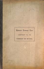 Melbourne Tram Museum
Document, Melbourne Tramways Trust (MTT), "MTT Contract No. 42 - Permanent Way Material", 1886
... railway station. Signed by George Duncan. Tenders closed 17 - 8 - 1886. Drawings detail the various components. ...railway station. Signed by George Duncan. Tenders closed 17 - 8 - 1886. Drawings detail the various components. ...Provides the specifications and conditions of contract for the manufacture, supply and delivery of the track or permanent way materials for the construction of the Melbourne cable tram system. Includes rails, yokes, fish plates, slot rails, bolts, and a delivery schedule to the Spencer St railway station. Signed by George Duncan. Tenders closed 17 - 8 - 1886. Drawings detail the various components. Has a Schedule of rates form - per tonne of materials. Document dated 21 June 1886.Yields information about the tendering of rail materials for the Melbourne Cable tram system. Document, The Melbourne Tramways Trust - Contract No. 42 - Permanent Way Material - 9 foolscap sheets, 3 folded drawings bound within heavy card covers, stapled covered in dark grey tape. 2nd & 3rd copies paper only, stapled and covered with brown tape on the left hand side.tramways, melbourne tramways trust, cable tramways, mtt, rails, yokes, tender documents, contracts -
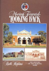 Bendigo Historical Society Inc.
Book - "Moving Forward - Looking Back", 1985
... component. Accordingly, the shire was proclaimed a rural city on 1 October 1990. Marong shire had a mixture of agricultural districts, eucalypt forests and mining localities. There was gold mining at Maiden Gully, Wilson’s Reef near Marong, Neilborough and Sebastian. The mining borough of Raywood was united with the shire on 1 October 1915. Lockwood was the shire’s administrative centre until 1908, when the centre was transferred to Marong. Marong municipality was served by two railway...component. Accordingly, the shire was proclaimed a rural city on 1 October 1990. Marong shire had a mixture of agricultural districts, eucalypt forests and mining localities. There was gold mining at Maiden Gully, Wilson’s Reef near Marong, Neilborough and Sebastian. The mining borough of Raywood was united with the shire on 1 October 1915. Lockwood was the shire’s administrative centre until 1908, when the centre was transferred to Marong. Marong municipality was served by two railway ...Marong Shire (1864-1994), immediately west and north of Bendigo, was proclaimed on 23 December 1864. Its western boundary was the Loddon River and its eastern boundary enclosed Kangaroo Flat which after World War II had a population of about 1000 persons. By 1990 Kangaroo Flat had an estimated population of about 10,000, thus giving the shire a pronounced urban component. Accordingly, the shire was proclaimed a rural city on 1 October 1990. Marong shire had a mixture of agricultural districts, eucalypt forests and mining localities. There was gold mining at Maiden Gully, Wilson’s Reef near Marong, Neilborough and Sebastian. The mining borough of Raywood was united with the shire on 1 October 1915. Lockwood was the shire’s administrative centre until 1908, when the centre was transferred to Marong. Marong municipality was served by two railway lines from Bendigo: north-westerly to Bridgwater-on-Loddon (1876) and northerly to Raywood and Pyramid Hill (1882). The Calder and Loddon Valley highways run generally north-west through the former municipality, through undulating to flat terrain, suitable for cereal growing and grazing. South of the Calder Highway the land is undulating to gullied. At the far south-west the Laanecoorie Reservoir lies on the Loddon River. In 1994 Marong rural city, with an area of 1489 sq km, had about 9000 cattle, 240,000 sheep and lambs and 11,000 pigs. About 6800 tonnes of barley and 27,000 tonnes of wheat were harvested. On 7 April 1994, Marong rural city was united with Bendigo city, Eaglehawk borough and Huntly and Strathfieldsaye shires to form Greater Bendigo city."Moving Forward - Looking Back" by Ruth Hopkins. Published for the Shire of Morong, Victoria 150th Anniversary Committee, by C G P Printing and Publishing, Bendigo. Printed in 1985. Soft cover book. Front cover is dark fawn brown in color with three photographs inset. Title and author's name in white on front cover and spine. Shire of Marong crest on front cover. Contains map of the then Marong Shire. Covers the history of Marong Shire. 119 pp. Contains both text and black and white images. ISBN 0949248037. shire, marong shire, kangaroo flat, marong