Showing 97 items matching "railway crescent"
-
 Port Melbourne Historical & Preservation Society
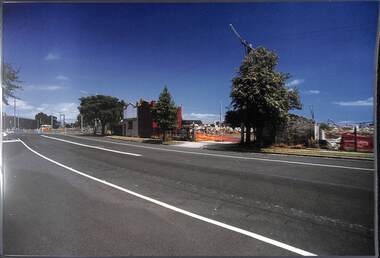
Photograph, James Lauritz, Railway Crescent demolition works, 1989 - 1990
... Railway Crescent demolition works......Railway Crescent...Railway Crescent demolition works in preparation for Beacon cove redevelopment James Lauritz print of Port Melbourne, laminated (one of 18). ...Port Melbourne Historical & Preservation Society Port Melbourne Town Hall 333 Bay Street Port Melbourne melbourne local government - city of port melbourne built environment james lauritz Railway Crescent Beacon Cove Railway Crescent demolition works in preparation for Beacon cove redevelopment James Lauritz print of Port Melbourne, laminated (one of 18). ...Railway Crescent demolition works in preparation for Beacon cove redevelopment James Lauritz print of Port Melbourne, laminated (one of 18). Copies of slides produced for Port Melbourne Councillocal government - city of port melbourne, built environment, james lauritz, railway crescent, beacon cove -
 Port Melbourne Historical & Preservation Society
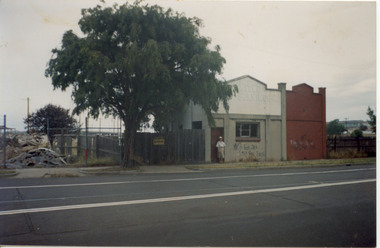
Photograph - Win Woodruff outside W C Cone & Co, Railway Crescent, Port Melbourne, 1989
... Win Woodruff outside W C Cone & Co, Railway Crescent, Port Melbourne...Cone & Co. in Railway Crescent c 1989, at time of demolition. This was the site of a former Prest home...Cone & Co. in Railway Crescent c 1989, at time of demolition. This was the site of a former Prest home Photograph Win Woodruff outside W C Cone & Co, Railway Crescent, Port Melbourne ...B&W photo of Win WOODRUFF nee PREST outside W.C. Cone & Co. in Railway Crescent c 1989, at time of demolition. This was the site of a former Prest homebuilt environment, business and traders, w c cove & co, winfred mary prest woodruff, woodruff family, prest family -
 Williamstown Botanic Gardens- Hobsons Bay City Council
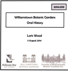
Oral History - Williamstown Botanic Gardens - Loris Wood, 5 August 2014
... 98 Railway Crescent, Williamstown, Victoria ...The interview is one of a series recorded in 2013-2014 to document memories and experiences of the Williamstown Botanic Gardens Loris was born and grew up in Williamstown. She lived across the street from the Gardens at 122 Osborne Street with her parents and siblings. A primary source of information on memories of the Gardens from the 1950s until the time of the interview.CD and transcript of interview with Loris Wood about her memories of Williamstown Botanic Gardenswilliamstown botanic gardens, hobsons bay city council, fish pond, cannons, aviary, adam lindsay gordon, pinetum, fearon reserve, band platform, clarke statue, ernie anderson, osborne street, weddings, horses, gardeners cottage, curators lodge -
 Unions Ballarat
W. G. Spence and the rise of the trade unions, Palmer, Helen et al, 1964
... Railway Crescent, Croydon, Victoria, Australia ...Contents: 1. Masters and servants 2. Miners 3. Shearers and bushworkers 4. The new unionism 5. Conflict and clash 6. Parliaments and unions Spence played a considerable role in the development of craft and industrial unions including the Shearers Union. He attended the 7th Intercolonial Trades Union Congress in 1891 and supported the Australasian Federation of Labour, which envisaged a firm link between industrial and political organization. Direct relevance to unionism in Ballarat and the 7th Intercolonial Trades Union Congress.Book; 56 pages. Cover: pink and white background; illustration of a union members' gathering; white and black lettering; author's name and title. Australian Landmarks series.Title page: name - unreadable.btlc, ballarat trades hall, ballarat trades and labour council, spence, william guthrie, spence, wg, shearers and rural workers' union, masters and servants act, miners union, parliaments, australasian federation of labour -
 City of Kingston
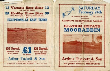
Pamphlet - Colour, Arthur Tuckett & Son, Auctioneers and Subdivisional Specialists, Auction of Station Estate, Moorabbin, 1923
... Sales plan for land in the suburb of Moorabbin, bounded by Railway Crescent, South Road, Jasper Road and Pattersons Road....Incorporates a map of the estate bordered by Pattersons Road, Japer Road, South Road and Railway Crescent. ...City of Kingston Parkdale Library 96 Parkers Road, Parkdale Parkdale Sales plan for land in the suburb of Moorabbin, bounded by Railway Crescent, South Road, Jasper Road and Pattersons Road. ...Sales plan for land in the suburb of Moorabbin, bounded by Railway Crescent, South Road, Jasper Road and Pattersons Road.The developing urban area of Moorabbin within the City of Kingston. This land sale pamphlet illustrates the subdivision of land within the municipality and the changing demographic of the district as new houses are constructed.Colour pamphlet advertising an auction of the Station Estate Moorabbin. Incorporates details of the shopping facilities, proximity to the railway line, variety of schools and churches in the area, and a sales plan for home sites and shop fronts. Incorporates a map of the estate bordered by Pattersons Road, Japer Road, South Road and Railway Crescent. Handwritten in grey pencil top right front page: Station Estate / late [indecipherable] Handwritten in red pencil on subdivision map: x [on majority of properties marked on the map] Handwritten in grey pencil on subdivision map: additional subdivisions drawn in and large lines drawn across the mapmoorabbin, land sales, estate -
Glen Eira Historical Society
Document - GARDENVALE
... ... Railway Crescent...Gardenvale Bent Thomas Brighton Caulfield Elsternwick Railway stations Lempriere family ‘Bentville’ Lempriere’s Paddock Market gardens Nepean Highway Nepean Road North Road Kooyong Road Polo Sheridan family Bluestone houses Bethlehem Hospital Land subdivision Begonia Street Gardenia Road Gardenia Street Magnolia Street Lantana Street Martin Street Shops ‘Ben Burb’ House names Padua Hospital Brighton O’Neill Miss O’Neill College O’Neill Richard O’Neill Estate Elster Avenue O’Neill College Estate Railway Crescent Denver Crescent Brentani Avenue College Street Rosstown Railway Brighton Cemetery Ross Mr Hawthorn Road Ormond Gardenvale Progress Association Elster Creek Parliamentary representatives Landscapes Gardenvale Road Railway lines Subways Traders Association Drainage Floods Document GARDENVALE ...This file contains two items about Gardenvale, which was previously all part of Caulfield: 1/Photocopied eight page document by M. Stewart, 1961, entitled ‘The Gardenvale Story’. It describes Gardenvale Railway and surrounding roads and land. Lempriere’s Paddock, rail tracks on the main roads for the use of market gardeners’ wagons. Sale of land for O’Neill College Estate and construction of a subway through the railway embankment to Gardenvale Shopping centre, including efforts by local people and the council for work to be completed and costs. Footnote is circa 1977. 2/Map of Glen Eira printed from Council website 20/06/2014 showing Glen Eira’s share of Gardenvale.gardenvale, bent thomas, brighton, caulfield, elsternwick, railway stations, lempriere family, ‘bentville’, lempriere’s paddock, market gardens, nepean highway, nepean road, north road, kooyong road, polo, sheridan family, bluestone houses, bethlehem hospital, land subdivision, begonia street, gardenia road, gardenia street, magnolia street, lantana street, martin street, shops, ‘ben burb’, house names, padua hospital, brighton, o’neill miss, o’neill college, o’neill richard, o’neill estate, elster avenue, o’neill college estate, railway crescent, denver crescent, brentani avenue, college street, rosstown railway, brighton cemetery, ross mr, hawthorn road, ormond, gardenvale progress association, elster creek, parliamentary representatives, landscapes, gardenvale road, railway lines, subways, traders association, drainage, floods -
Glen Eira Historical Society
Document - Shoobra Road, 88, Elsternwick
... ... Railway Crescent...Shoobra Road Elsternwick Gisbourne Street Glen Huntly Road Railway Crescent Gladstone Parade ‘Cavers Carre’ Riddell John Carre (MLA) Riddell Walter Carre Riddell Crescent Orrong Road Riddell Parade Brook Samuel Morris Albert E. ...This file contains one item: 1/Typed history of streets surrounding Shoobra Road, and brief history of area. Gives listings of owners of property from Brighton Historical Society researchers. Handwritten working notes also of same details.shoobra road, elsternwick, gisbourne street, glen huntly road, railway crescent, gladstone parade, ‘cavers carre’, riddell john carre (mla), riddell walter carre, riddell crescent, orrong road, riddell parade, brook samuel, morris albert e., moreland elizabeth mrs., scott w. thomas, burn mrs., lewis kenneth, bullock hilary, londells rosemary -
Glen Eira Historical Society
Letter - O’Neill College, Nagle Avenue, 2, Elsternwick
... ... Railway Crescent...Subdivisions Railway Crescent Nagle Avenue Denver Court Robinson C.H. ...2 articles related to O’Neill College. Photocopy of advertising leaflet for the auction of house- blocks, on the O’Neill College Estate, Elsternwick Auction held 08/04/1922. Copies of 4 letters dated 17/07/1936 to 12/04/1937 from the Victorian Public Health Dept. to the Mother Superior, O’Neill College, regarding alterations to the college buildings.o’ neill college estate, elsternwick, burke t. m., subdivisions, railway crescent, nagle avenue, denver court, robinson c.h., gardenvale railway station, presentation novitiate, auctions, catholic schools, convents, nuns, colleges, school houses, building construction, building permits, public health department, o'neill college, o'neill college estate, elsternwick railway stations, brentani avenue, caulfield city council -
Glen Eira Historical Society
Letter - RIDDELL PARADE, 78, ELSTERNWICK
... ... Railway Crescent...Walker Mary Riddell John Carre Cavers Carre Ross William Murray Elsternwick Carnegie Rosstown Railway Lines Rosstown Junction Railway Jefferson M G B Ward Cole George Cole George Ward Williams Fred Hughes Horace C Railway Crescent Riddell Parade Orrong Road Cottages Land Subdivision Coolarra Bayview Villa Bay View Villa Plaster moujlds Fireplaces A. ...Two items about this property: 1/Contains a report for A J Barley Pty Ltd (Real Estate Agent) by Hilary Bullock and Rosalind Landells of Brighton Historical Society on the property at 78 Riddell Parade Coolara from November 15 1985. Includes a brief history of the area, a list of owners/residents and some information on architectural details of the house. Also contains a letter of apology and explanation dated 30 November 1985 from Mrs Landells over an error of interpretation which led to a mistake in the report. 2/Auction flyer, date unknown (but likely circa November 1985), for Bay View Villa for rela estate agent A J Barley.walker mary, riddell john carre, cavers carre, ross william murray, elsternwick, carnegie, rosstown, railway lines, rosstown junction railway, jefferson m g b, ward cole george, cole george ward, williams fred, hughes horace c, railway crescent, riddell parade, orrong road, cottages, land subdivision, coolarra, bayview villa, bay view villa, plaster moujlds, fireplaces, a. j. barley pty ltd, estate agents, o'brien dorothy, victorian style, 'cavers carre', house names -
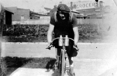 Surrey Hills Historical Society Collection
Photograph, Arthur Lyons of 55 Sunbury Crescent, Surrey Hills
... ...stirling crescent...railway...Taken outside the Lyons' home in Sunbury Crescent with Union Road shops in the background. It shows the brick substation which stood by the railway gates. ...Arthur had no relatives to distribute the material to. sunbury crescent surrey hills stirling crescent railway line grocers (Mr) arthur lyons (Mr) arthur frederick lyons cyclist A black and white photograph of a man, with his bicycle. ...Taken outside the Lyons' home in Sunbury Crescent with Union Road shops in the background. It shows the brick substation which stood by the railway gates. The paling fences are along Stirling Crescent, across the railway line. Arthur was the only son of Frederick Adolphus Lyons (1891-1980) who was born in Surrey Hills, son of Thomas and Catherine Lyons. He married Elizabeth Ruby Hall in 1918. They lived at 55 Sunbury Crescent. The Lyons’ home was called ‘Knopshambury’ - this was probably a misspelling of Knockshanbally in Co Kilkenny, the birth place of Fred’s father, Thomas Edmund Josias Lyons (1846-1915). Arthur Lyons was born in Surrey Hills on 12 Jun 1920. He became a motor mechanic / welder and lived at 55 Sunbury Crescent. This is one of a series of photos donated by Arthur Lyons. The donation was made while he was in hospital. He died shortly afterwards (23 Sep 1990). Donation was finalised by a neighbour, Mrs Florence Ann Armitstead, wife of Glen Victor Armitstead. Glen was a local hairdresser. They moved to 11 Sunbury Crescent after their marriage in 1939. Arthur had no relatives to distribute the material to.A black and white photograph of a man, with his bicycle. In the background is the railway line and buildings one of which has a sign advertising a grocer.sunbury crescent, surrey hills, stirling crescent, railway line, grocers, (mr) arthur lyons, (mr) arthur frederick lyons, cyclist -
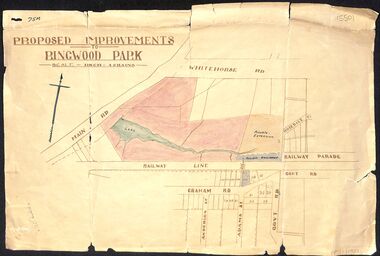 Ringwood and District Historical Society
Map, Proposed Improvements to Ringwood Park (Ringwood Lake) dated 14 January 1927
... The map shows Rosedale Crescent and Railway Parade, both of which exist in 2024. ...The map shows Rosedale Crescent and Railway Parade, both of which exist in 2024. ...Proposed Improvements to Ringwood Park (Ringwood Lake) dated 14 January 1927, signed Cr McCaskill. Main Road is Whitehorse Road (Maroondah Highway), and Mt Dandenong Road is incorrectly labelled Whitehorse Road. The map shows Rosedale Crescent and Railway Parade, both of which exist in 2024. On the bottom of the map, south of the railway line, showing proposed streets - Graham Road, Anderson Street and Adams Street - in preparation for the sale of the Theo Anderson property. That area is now Bedford Park. -
 Eltham District Historical Society Inc
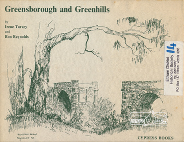
Book, Irene Turvey et al, Greensborough and Greenhills / words by Irene Turvey ; Drawings by Ron Reynolds, 1973
... Contents cover : Blue stone bridge, Introduction, House cnr Church and Hailes Street, House - 25 Hailes Street, Yandell Reserve, Greensborough Hotel, Lobb's Kiosk, House - 49 Grimshaw Street, View of Greensborough (from Delphin Crescent), Railway Station, Old Barn (near Greensborough Railway Station), Partington's Flat and River Valley, Rand Street Bridge, Lower Main Street, Greenbriar Nursery, Hitching rail, Ashmead - Dr Cordner's Home, Greensborough Primary School, House - cnr St Helena and Diamond Creek Raods, Sondermeyer's Hill, Methodist Church, Football Pavilion, Cemetery, St Katherine's Church, St. ...Contents cover : Blue stone bridge, Introduction, House cnr Church and Hailes Street, House - 25 Hailes Street, Yandell Reserve, Greensborough Hotel, Lobb's Kiosk, House - 49 Grimshaw Street, View of Greensborough (from Delphin Crescent), Railway Station, Old Barn (near Greensborough Railway Station), Partington's Flat and River Valley, Rand Street Bridge, Lower Main Street, Greenbriar Nursery, Hitching rail, Ashmead - Dr Cordner's Home, Greensborough Primary School, House - cnr St Helena and Diamond Creek Raods, Sondermeyer's Hill, Methodist Church, Football Pavilion, Cemetery, St Katherine's Church, St. ...Pen and ink sketches accompanied by appropriate text in double page spreads. Contents cover : Blue stone bridge, Introduction, House cnr Church and Hailes Street, House - 25 Hailes Street, Yandell Reserve, Greensborough Hotel, Lobb's Kiosk, House - 49 Grimshaw Street, View of Greensborough (from Delphin Crescent), Railway Station, Old Barn (near Greensborough Railway Station), Partington's Flat and River Valley, Rand Street Bridge, Lower Main Street, Greenbriar Nursery, Hitching rail, Ashmead - Dr Cordner's Home, Greensborough Primary School, House - cnr St Helena and Diamond Creek Raods, Sondermeyer's Hill, Methodist Church, Football Pavilion, Cemetery, St Katherine's Church, St. Helena, Civic Centre, Briar Hill Timber Mill, 24 River Street, Kelly's Garden Supplies, 158 Main Street, Old Swimming pool, 105 Main Street.Hardback; 62 p. : ill., map ; 19 x 25 cm.ISBN 0909807108 Signed by author and illustrator Two copiesgreenhills, greensborough -
 Sunshine and District Historical Society Incorporated
Newspaper - Ray Carlton Significant Papers Collection
... Albans Developments Start To Move, Forges, War Hits The West, Braybrook Becomes Sunshine 2881.02 - Ray Carlton Significant Papers Collection - The Mail We're 60 Diamond Jubilee 1984, The Footscray Mail Office, Braybrook Becomes Sunshine 2881.03 - Ray Carlton Significant Papers Collection - The Advocate Golden Anniversary Issue 1974, The Advocate First Fifty Years, Sunshine Shopping Centre City Place, Clarence Gibson Carlton, Sunshine Post Office, Donald "Don" McKay, Anderson Road & Sun Crescent Railway Crossings, Sunshine Technical School, Sunshine Fire Stations, Albion Land Sales, Sunshine Overpass 2881.04 - Ray Carlton Significant Papers Collection - The Advocate Sunshine Declared City Anniversary 1978, Albion Is Greek, Sunshine Sports Centre, The Sage Of Sunshine's Hugh Victor McKay, Railway Work Shops 2881.05 - Ray Carlton Significant Papers Collection - The Star Celebrating Sunshine 150 Years Of Local Government 2011, Kevin Wheelahan Gardens Family Day, Sunshine Historical Cards 2881.06 - Ray Carlton Significant Papers Collection - The Advocate Sunshine & Braybrook Celebrating 150 Years Of Local Government 2010, John Darling & Sons Flour Mill Heritage Listed 2881.07 - Ray Carlton Significant Papers Collection - Sunshine Advocate 1860 - 1960 Sunshine Illustrated Commemorating 100 Years Of Progress 1960, Our First Explorers Followed The River, Grimes & Batman 2881.08 - Ray Carlton Significant Papers Collection - The Sun 60th Anniversary Souvenir 1982 2881.09 - Ray Carlton Significant Papers Collection - The Mail We're 60 Diamond Jubilee 1984, The Footscray Mail Office, Braybrook Becomes Sunshine 2881.10 - Ray Carlton Significant Papers Collection - Sunshine Plaza Openning 1983 2881.11 - Ray Carlton Significant Papers Collection - The Advocate We're 60 The Way We Were And Today 1984, Sunshine Plaza Opening, The Advocate's Stories Of The Passing Years 2881.12 - Ray Carlton Significant Papers Collection - Sunshine Advocate 1st Edition 1st March 1924, Help Us To Help You In The District's Progress 2881.13 - Ray Carlton Significant Papers Collection - The Western Times Souvenir Of Century Footscray Shopping Centre Celebrates 100 Years, Nicholson Street, Footscray Mall, Charles Grimes, Encildoune House 2881.14 - Ray Carlton Significant Papers Collection - The Age Sunshine A Community Report 1974, Grants Aid City To Improve Way Of Life, Sunshine Municipal Offices, Sims Metal, Inventor Gave The City Its Name, Firestone Australia, Olex Cables, ARC 2881.15 - Ray Carlton Significant Papers Collection - The Age Councils Revolt Against The Secret Freeways 1974 2881.16 - Ray Carlton Significant Papers Collection - The Age Spot Light On The Western Suburbs 1987, Werribee Park 2881.17 - Ray Carlton Significant Papers Collection - The Advocate Carlton Brothers 1984 2881.18 - Ray Carlton Significant Papers Collection - Weekender Sunshine, Rainbow House, Dining, Sport, Youth 2881.19 - Ray Carlton Significant Papers Collection - The Age Shopping Centre Site Was Once A Hole 1974, High Point West Opens September 1975 2881.20 - Ray Carlton Significant Papers Collection - Mirror Highpoint West Opening 1975 2881.21 - Ray Carlton Significant Papers Collection - The Advocate Massive Shopping Complex 1981, Footscray Private Hospital 2881.22 - Ray Carlton Significant Papers Collection - Advertiser Clarrie Carlton Dies Age 79 1972 2881.23 - Ray Carlton Significant Papers Collection - Johnny Farnham At Deer Park Hotel, Advocate Founder Fies Clarrie Carlton 1972, Peter Norman 2881.24 - Ray Carlton Significant Papers Collection - The Advocate Australia Day Program Will Appeal To All 1965, Sunshine Advocate Changes Ownership, Works Starts On New Town Hall, Sunshine New Library 2881.25 - Ray Carlton Significant Papers Collection - The Advocate Braybrook Centenary 1971, Education Department Protests, Braybrook & Sunshine Shire Halls, Marian College library, Mathews Hill Reserve, New Private Hospital Sunshine North 2881.26 - Ray Carlton Significant Papers Collection - The Argus Souvenir Of A Century Of Progress 1934 2881.27 - Ray Carlton Significant Papers Collection - Profile Community Newspaper 1983, Sunshine North School Crossing 2881.28 - Ray Carlton Significant Papers Collection - The Sun Sixty Years Of Sun Days 1982, First Federal Parliment At Canberra, Southern Cross Flyers 2881.29 - Ray Carlton Significant Papers Collection - Images For The Sunshine Advocate 1860 - 1960 Sunshine Illustrated Commemorating 100 Years Of Progress 1960 2881.30 - Ray Carlton Significant Papers Collection - The Advocate Axe To Fall On St. ...Albans Developments Start To Move, Forges, War Hits The West, Braybrook Becomes Sunshine 2881.02 - Ray Carlton Significant Papers Collection - The Mail We're 60 Diamond Jubilee 1984, The Footscray Mail Office, Braybrook Becomes Sunshine 2881.03 - Ray Carlton Significant Papers Collection - The Advocate Golden Anniversary Issue 1974, The Advocate First Fifty Years, Sunshine Shopping Centre City Place, Clarence Gibson Carlton, Sunshine Post Office, Donald "Don" McKay, Anderson Road & Sun Crescent Railway Crossings, Sunshine Technical School, Sunshine Fire Stations, Albion Land Sales, Sunshine Overpass 2881.04 - Ray Carlton Significant Papers Collection - The Advocate Sunshine Declared City Anniversary 1978, Albion Is Greek, Sunshine Sports Centre, The Sage Of Sunshine's Hugh Victor McKay, Railway Work Shops 2881.05 - Ray Carlton Significant Papers Collection - The Star Celebrating Sunshine 150 Years Of Local Government 2011, Kevin Wheelahan Gardens Family Day, Sunshine Historical Cards 2881.06 - Ray Carlton Significant Papers Collection - The Advocate Sunshine & Braybrook Celebrating 150 Years Of Local Government 2010, John Darling & Sons Flour Mill Heritage Listed 2881.07 - Ray Carlton Significant Papers Collection - Sunshine Advocate 1860 - 1960 Sunshine Illustrated Commemorating 100 Years Of Progress 1960, Our First Explorers Followed The River, Grimes & Batman 2881.08 - Ray Carlton Significant Papers Collection - The Sun 60th Anniversary Souvenir 1982 2881.09 - Ray Carlton Significant Papers Collection - The Mail We're 60 Diamond Jubilee 1984, The Footscray Mail Office, Braybrook Becomes Sunshine 2881.10 - Ray Carlton Significant Papers Collection - Sunshine Plaza Openning 1983 2881.11 - Ray Carlton Significant Papers Collection - The Advocate We're 60 The Way We Were And Today 1984, Sunshine Plaza Opening, The Advocate's Stories Of The Passing Years 2881.12 - Ray Carlton Significant Papers Collection - Sunshine Advocate 1st Edition 1st March 1924, Help Us To Help You In The District's Progress 2881.13 - Ray Carlton Significant Papers Collection - The Western Times Souvenir Of Century Footscray Shopping Centre Celebrates 100 Years, Nicholson Street, Footscray Mall, Charles Grimes, Encildoune House 2881.14 - Ray Carlton Significant Papers Collection - The Age Sunshine A Community Report 1974, Grants Aid City To Improve Way Of Life, Sunshine Municipal Offices, Sims Metal, Inventor Gave The City Its Name, Firestone Australia, Olex Cables, ARC 2881.15 - Ray Carlton Significant Papers Collection - The Age Councils Revolt Against The Secret Freeways 1974 2881.16 - Ray Carlton Significant Papers Collection - The Age Spot Light On The Western Suburbs 1987, Werribee Park 2881.17 - Ray Carlton Significant Papers Collection - The Advocate Carlton Brothers 1984 2881.18 - Ray Carlton Significant Papers Collection - Weekender Sunshine, Rainbow House, Dining, Sport, Youth 2881.19 - Ray Carlton Significant Papers Collection - The Age Shopping Centre Site Was Once A Hole 1974, High Point West Opens September 1975 2881.20 - Ray Carlton Significant Papers Collection - Mirror Highpoint West Opening 1975 2881.21 - Ray Carlton Significant Papers Collection - The Advocate Massive Shopping Complex 1981, Footscray Private Hospital 2881.22 - Ray Carlton Significant Papers Collection - Advertiser Clarrie Carlton Dies Age 79 1972 2881.23 - Ray Carlton Significant Papers Collection - Johnny Farnham At Deer Park Hotel, Advocate Founder Fies Clarrie Carlton 1972, Peter Norman 2881.24 - Ray Carlton Significant Papers Collection - The Advocate Australia Day Program Will Appeal To All 1965, Sunshine Advocate Changes Ownership, Works Starts On New Town Hall, Sunshine New Library 2881.25 - Ray Carlton Significant Papers Collection - The Advocate Braybrook Centenary 1971, Education Department Protests, Braybrook & Sunshine Shire Halls, Marian College library, Mathews Hill Reserve, New Private Hospital Sunshine North 2881.26 - Ray Carlton Significant Papers Collection - The Argus Souvenir Of A Century Of Progress 1934 2881.27 - Ray Carlton Significant Papers Collection - Profile Community Newspaper 1983, Sunshine North School Crossing 2881.28 - Ray Carlton Significant Papers Collection - The Sun Sixty Years Of Sun Days 1982, First Federal Parliment At Canberra, Southern Cross Flyers 2881.29 - Ray Carlton Significant Papers Collection - Images For The Sunshine Advocate 1860 - 1960 Sunshine Illustrated Commemorating 100 Years Of Progress 1960 2881.30 - Ray Carlton Significant Papers Collection - The Advocate Axe To Fall On St. ...Collection of Significant Papers -
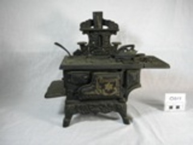 Upper Yarra Museum
Stove, Miniature
... Upper Yarra Museum Old Railway Station 2415C Warburton Highway Yarra Junction yarra-valley-and-dandenong-ranges Story to be placed here - Available to public wood iron tin cast stove black cast iron star solid fuel chimney flat iron stand flat stand hot plates frying pan bolt screws legs toy miniature crescent made in taiwan taiwan wood box crescent, star, scrolls, Minature cast iron, Black Solid Wood Stove with miniature utensils. ...Story to be placed here - Available to publicMinature cast iron, Black Solid Wood Stove with miniature utensils. The stove is on legs with left hand extension for pots, right hand extension with holes, removeable hot plates [4 round 1 rectangle] tin chimney with folded join and seperate decorative cover with pot stands x2 , front door opens on hinges with internal gold pan with gold crescent logo. Frying pan, hot plate handle and "swan flat iron on stand. Solid fuel space with tin base. 2 screws and bolts used to assemble stove. 14 removeable parts.crescent, star, scrolls, wood, iron, tin, cast, stove, black, cast iron, star, solid, fuel, chimney, flat iron stand, flat, stand, hot plates, frying, pan, bolt, screws, legs, toy, miniature, crescent, made in taiwan, taiwan, wood box -
Glen Eira Historical Society
Article - Rosstown Railway
... Railway Routes... Carnegie Neville Street... Carnegie Miller Street... Factories... Market Gardens... Horticulture... Peat... Soils... Land Forms... Topography... Geology... Civic Issues... Cone Sugar Industry... Elsternwick Plaza... Elsternwick... Glenhuntly Road... Parks and Reserves... EE Gunn Reserve... Caulfield Racecourse... Sportsgrounds... Caulfield... Carnegie... Riddell Parade... Clarence Street... Aileen Avenue... Princes Park... Dover Street... Marara Road... Oakleigh Road... Rosanna Street... Murrumbeena Crescent...Murray Ross Murray Sugar Beet Mills Mills Elsternwick Land Transport Railways Railway Lines Railway Routes Carnegie Neville Street Carnegie Miller Street Factories Market Gardens Horticulture Peat Soils Land Forms Topography Geology Civic Issues Cone Sugar Industry Elsternwick Plaza Elsternwick Glenhuntly Road Parks and Reserves EE Gunn Reserve Caulfield Racecourse Sportsgrounds Caulfield Carnegie Riddell Parade Clarence Street Aileen Avenue Princes Park Dover Street Marara Road Oakleigh Road Rosanna Street Murrumbeena Crescent North Road Kooyong Road Hawthorn Road Booran Road Koornang Road Poath Road Warragul Road Railway Platforms Railway Buildings Bambra Road Swamps Landforms Landfill Council Landfill Railway Bridges Bridges Railway Underpasses Sporting Clubs Tennis Clubs Bowls Clubs Rosstown Railway Rosanna Street Reserve Maps Railway Maps LIVING IN GLEN EIRA Weickhardt Ian Jowett Des Caulfield South Curraweena Road Oakleigh Caulfield Technical School RETURN TO ROSSTOWN Beet Sugar Industry Crops Land Booms Land Development and Subdivisions Bent Thomas Fink Benjamin Sugar Works Rosstown Hotel Oamdenong Road ROSSTOWN DRY CLEANERS Shops Rosstown Road Rosstown Plate People by Circumstance Migrants Accountants Occupations Professionals THE GRANGE Real Estate Grange Road Financial Agents Judges ROSSTOWN ESTATE Financial Trouble Rabbit Preserving Breweries Political Debates Political Issues Political Electorates Politics Political Science Debt Financial Loans Court Procedures Court Cases Legal Events and Activities MALLESON AND RIGGALL Widowers SEABEACH RAILWAY Economics Economic Deadline Depression 1890s Economic Crash Mortgages Divorce Social Problems Poverty Ross Claude Ross Roderick World War 1914-1918 Wars Military History Servicemen AUSTRALIAN FLYING CORPS Engineers Caulfield Council Swagmen Homelessness Glenhuntly Road Glenhuntly Road Tram Woornack Road Leila Road Wild Cherry Road Melten Avenue Illustrations Steam Trains Trains Horse and Cart Horse-drawn Transport Railway Stations Article Rosstown Railway ...This file contains three items: 1/A review of the ROSSTOWN RAIL TRAIL from LIVING IN GLEN EIRA, vol. 11, 2004, Issue 4, no. 25, date and author unknown. The review explains the purpose of the Rail Trail with a brief narrative of the history behind Rosstown Sugar Mill Railway line. Concluding with information on the location of the Trail and the expected time required to walk the entire track included in the review is a map of the Rail Trail, which marks significant sites along the trail with historic pictures. 2/A newspaper article from THE AGE, dated Tuesday 21/10/1980 and written by Iola Matthews, reporting on the circumstances that led to the publication of the book RETURN TO ROSSTOWN written by Des Jowett and Ian Weickhardt. The article begins with a brief biography of the authors before moving into details of the book’s content, providing a further biography of W. Murray Ross which includes information on his financial ventures – particularly the Rosstown Rail – his marriage and children. The article includes a black and white photograph of Weickhardt and Jowett walking along the route of the railway line, an illustration of the Rosstown sugar works and a map of the area surrounding the site of the mill. 3/Three photocopies of a black and white illustration of the Rosstown sugar works from the east, undated and artist unknown.rosstown rail trail, rosstown, ross william, ross w. murray, ross murray, sugar beet mills, mills, elsternwick, land transport, railways, railway lines, railway routes, carnegie neville street, carnegie miller street, factories, market gardens, horticulture, peat, soils, land forms, topography, geology, civic issues, cone sugar industry, elsternwick plaza, elsternwick, glenhuntly road, parks and reserves, ee gunn reserve, caulfield racecourse, sportsgrounds, caulfield, carnegie, riddell parade, clarence street, aileen avenue, princes park, dover street, marara road, oakleigh road, rosanna street, murrumbeena crescent, north road, kooyong road, hawthorn road, booran road, koornang road, poath road, warragul road, railway platforms, railway buildings, bambra road, swamps, landforms, landfill, council landfill, railway bridges, bridges, railway underpasses, sporting clubs, tennis clubs, bowls clubs, rosstown railway, rosanna street reserve, maps, railway maps, living in glen eira, weickhardt ian, jowett des, caulfield south, curraweena road, oakleigh, caulfield technical school, return to rosstown, beet sugar industry, crops, land booms, land development and subdivisions, bent thomas, fink benjamin, sugar works, rosstown hotel, oamdenong road, rosstown dry cleaners, shops, rosstown road, rosstown plate, people by circumstance, migrants, accountants, occupations, professionals, the grange, real estate, grange road, financial agents, judges, rosstown estate, financial trouble, rabbit preserving, breweries, political debates, political issues, political electorates, politics, political science, debt, financial loans, court procedures, court cases, legal events and activities, malleson and riggall, widowers, seabeach railway, economics, economic deadline, depression 1890s, economic crash, mortgages, divorce, social problems, poverty, ross claude, ross roderick, world war 1914-1918, wars, military history, servicemen, australian flying corps, engineers, caulfield council, swagmen, homelessness, glenhuntly road, glenhuntly road tram, woornack road, leila road, wild cherry road, melten avenue, illustrations, steam trains, trains, horse and cart, horse-drawn transport, railway stations -
Glen Eira Historical Society
Letter - Rosstown Railway
... Railway Station... Oakleigh Road... Melten Avenue... Miller Street... Munro Avenue... Lord Reserve... Neerim Road... Toolambool Road... The Rosstown Hotel... Rosanna Street... Murrumbeena Crescent...RETURN TO ROSSTOWN: RAILWAYS LAND SALES AND SUGAR BEET VENTURES IN CAULFIELD Land Sales Walking Trails Ross William Murray Transport Objects Locomotion Walking Cycling Driving Sports Country Mansions People Caulfield John Builders Construction and Demolition Workers Occupations Careers Professionals Topography Geology Landforms Horticulture Market Gardens Primary Industry Workers City of Caulfield MOOD KEE Pennington Harold Annual General Meetings Caulfield Town Hall Glen Eira City Council Carnegie Carnegie Station Rosstown Station People by Circumstance Migrants Sugar Beet Sugar Beet Mill Sugar Beet Industry Mills Factories SEA BEACH LINES Bent Thomas Parliamentary Representatives Neville Street Miller Street Lemann’s Swamp Reserve Koornang Park Cane Sugar Industry Breweries Rabbit Processing Plants Health Establishments Hospitals Food Production Establishments Abattoirs Thieves Social Problems Vagrants Theft Squatting Financial Economics Debt Finance Industry Insurance Companies Company Managers Bentleigh Ross Leila THE GRANGE Leila Road Wild Cherry Road Financial Trouble Mortgages Gisborne Street Archibald Street Riddell Parade VICTORIA RAILWAYS Glen Huntly Road Clarence Street College Street Gladstone Parade Parrell Street Aileen Avenue Seaview Street Land Subdivisions Dover Street Sussex Street Landfill Marara Road Booran Road Woodville Avenue Dorothy Avenue Ormond Park Royal Avenue Ormond Railway Station Oakleigh Road Melten Avenue Miller Street Munro Avenue Lord Reserve Neerim Road Toolambool Road The Rosstown Hotel Rosanna Street Murrumbeena Crescent Commercial Establishments The National Bank Rosstown Road Kangaroo Road Poath Road Freda Street Hughesdale Kindergarten Oakleigh Council Hughesdale Community Centre Civic Establishments Galbally Reserve Plaques Warrigal Road OUT AND ABOUT BROCHURES Orion Estate Letter Rosstown Railway ...This file contains four items: 1/A black and white photocopy of a letter dated either 07/08/1889 or 09/08/1889, from Robert Lundon to an unidentified recipient discussing an agreement reached between the author – on behalf of the recipient – and Soon Hang Hi in regard, in regards to the allotment known as Webber’s. The agreement is outlined in the letter in what appears to be Chinese characters, and includes the marks of Robert Lundon and Soon Hang Hi. File note from Joy Wu states that the calligraphy is not Mandarin or traditional Chinese. 2/Three sheets of hand-written working notes with information taken from the Victorian Government Gazette on THE ROSSTOWN AND MURRUMBEENA LAND COMPANY LIMITED, THE ROSSTOWN JUNCTION RAILWAY AND PROSPERITY COMPANY LIOMITED, and THE ROSSTOWN JUNCTION, ELSTERNWICK, AND OAKLEIGH RAILWAY COMPANY LIMITED, covering dates between 1887 and 1894. The notes concern meetings and creditors claims relevant to the companies, with reference numbers for the information source. Date and author of the notes are not recorded. 3/A black and white photocopy of the a partial map of the Rosstown Railway and surrounding area, undated. The map includes the names of landholders in the areas of Brighton, Garden Vale and Elsternwick, as well as other railway lines present in the region. 4/A fold-out map and guide of the Rosstown Rail Trail, including a brief general history of Caulfield as well as a more extensive biography of William Murray Ross and the Rosstown Railway. The map marks and describes significant sites along the trail, including photographs of some of these sites, provided by DF Jowett.documents, correspondence, webber’s, lundon robert, chinese characters, ethnic communities, signatures, text, settlements, taxes, fraser john grieves, lovell r.h., price davies, meetings, communication activities, soon hang hi, commercial events and activities, the rosstown and murrumbeena land company limited, victorian government gazette, bulmer richard, parry john, osment henry, shareholders, creditors claims, the rosstown junction railway and property company limited, finch and best, lawyers, the rosstown junction elsternwick and oakleigh railway company limited, cameron w.c., phillips p.d., garden vale, elsternwick, elsternwick railway station, rosstown, rosstown railway, thomas street, bay street, kooyong road, melbourne and brighton railway, hawthorn road, bambra road, caulfield and frankston railway, booran road, grange road, koornang road, murrumbeena road, north road, north road railway station, east brighton railway station, south road, railway routes, railway lines, railways, land transport, murphy j., caulfield, hamilton t.f., dane p., holloway, webb, ailee john, payne t.b., brodie chas, dane john, o’neil h., mccombie john, mcmillane a., smyth c.d., cooper, ebden, landholders, jeffrey j.d., gill j., balcombe a.e., cooper h., mcnab j., white j., sutherland j., greeves a.f.a., newton m.c., chamley f.b., fowler j., inglis p., grant t., stooke j., swanson g., cochrane c., adams e.b., mccombie thas, keyes robert, brighton cemetery, burials grounds and graveyards, war-ein road, were j.b., holland j., mcmahon c., winter t.l.m., dendy henry, mitchell w., jackson s., were j.e., wickham francis dawe, bryant jane, east brighton railway station, railway stations, maps, allotments, land titles, roads and streets, rosstown rail trail, city of glen eira, tourism, trains, tourism information bureaus, tours, pamphlets, elsternwick railway park, oakleigh junction, princes park, ee gunn reserve, packer park, sites, jowett d.f., weickhardt i.g., return to rosstown: railways land sales and sugar beet ventures in caulfield, land sales, walking trails, ross william murray, transport objects, locomotion, walking, cycling, driving, sports, country mansions, people, caulfield john, builders, construction and demolition workers, occupations, careers, professionals, topography, geology, landforms, horticulture, market gardens, primary industry workers, city of caulfield, mood kee, pennington harold, annual general meetings, caulfield town hall, glen eira city council, carnegie, carnegie station, rosstown station, people by circumstance, migrants, sugar beet, sugar beet mill, sugar beet industry, mills, factories, sea beach lines, bent thomas, parliamentary representatives, neville street, miller street, lemann’s swamp reserve, koornang park, cane sugar industry, breweries, rabbit processing plants, health establishments, hospitals, food production establishments, abattoirs, thieves, social problems, vagrants, theft, squatting, financial economics, debt, finance industry, insurance companies, company managers, bentleigh, ross leila, the grange, leila road, wild cherry road, financial trouble, mortgages, gisborne street, archibald street, riddell parade, victoria railways, glen huntly road, clarence street, college street, gladstone parade, parrell street, aileen avenue, seaview street, land subdivisions, dover street, sussex street, landfill, marara road, booran road, woodville avenue, dorothy avenue, ormond park, royal avenue, ormond railway station, oakleigh road, melten avenue, miller street, munro avenue, lord reserve, neerim road, toolambool road, the rosstown hotel, rosanna street, murrumbeena crescent, commercial establishments, the national bank, rosstown road, kangaroo road, poath road, freda street, hughesdale kindergarten, oakleigh council, hughesdale community centre, civic establishments, galbally reserve, plaques, warrigal road, out and about brochures, orion estate -
Glen Eira Historical Society
Book - CAULFIELD CENTENARY 1957
... Elections Political processes Local government Springthorpe Reserve Greenmeadows Gardens Business and finance Roads and streets Caulfield Racecourse East Caulfield Reserve Mackinnon Reserve Hawthorn Road Balaclava Road Murrumbeena Road Lempriere Avenue Victoria Street Koornang Road Lord Reserve Lyons Street Murrumbeena Reserve Kangaroo Road Ormond Park Beatty Crescent Foch Street Packer Reserve Oakleigh Road Leila Road Prices Park Bambra Road Riley Reserve Playgrounds Town Hall Maternal and child health centres Truganini Road Grange Road Senior Citizens centre Barkley Sir Henry Moore David Handasyde Gilbert Caulfield School Room Harris G.W. Semple John Dempsey William Brooks W.A. Wilson Thomas Lyall William Murrum Murrumbeen lifestyle ‘Greenmeadows’ House Lempriere family Aboriginal culture ‘Rippon Lea’ House Caulfield John ‘Slaney’s’ Home Alma Road Paddy’s Swamp Racecourse Hotel Caulfield Technical College Bevan Mr. ‘Grosmont’ Hart John Railways ...This file contains four items 1/Two copies of a twenty-four page booklet titled CITY OF CAULFIELD CENTENARY 1857-1957, created by the Caulfield City Council and printed by Peter Isaacson Pty Limited, Melbourne. The booklet details important aspects of Caulfield’s history including council procedures, the Caulfield Road District Proclamation, the first election and a summary of 100 years of local government with a description of the present Caulfield in 1957. The booklet also includes several pictures of various Caulfield landmarks and people including one of Caulfield City Councillors (11 men and 1 woman). Also one photocopied version of this booklet. 2/Eleven pages of typed notes for the City of Caulfield Centenary booklet. All notes are undated and incomplete. Two pages titled NOTES on THE HISTORY and PROGRESS OF THE CITY OF CAULFIELD, author unknown. Three and a half pages titled THE STRUCTURE OF LOCAL GOVERNMENT IN VICTORIA, author unknown. Five pages titled 100 YEARS OF LOCAL GOVERNMENT – EARLY CAULFIELD, by Mrs A. P. Bell. 3/A typed letter to Miss V. Webb-Langdon from the Town Clerk H.G. Nelson, acknowledging her contribution to historical details for the Caulfield Council’s Centenary booklet, dated 24/12/1957. 4/A handwritten letter and a handwritten note regarding the acquisition of notes for the Caulfield Centenary booklet. The letter is dated 03/08/2006 and the note is dated 09/02/2007.city of caulfield centenary, caulfield road district, sinclair a.j.g., city hall, war memorials, gamble h.a., machin l.r., bunny f.c.d., caulfield park, koornang reserve, parton e.m., sims h.e., thomson w.r., gunn e.e., yorston j.s., wallace g.e. mrs, green w.c., jenner e.r., ward boundaries, dandenong road, queens avenue, normanby road, station street, bond street, glen eira road, orrong road, poath road, north road, booran road, nepean highway, glen huntly road, glenhuntly road, inkerman road, hotham street, nelson h.g., fullard w.r., mackley g.j., ellis k.i, crosbie m.r., nutting b.i., body j.h., pritchard r.j., guildford l.t.g., lund l.m., street h.c., reynolds a.w., elections , political processes, local government, springthorpe reserve, greenmeadows gardens, business and finance, roads and streets, caulfield racecourse, east caulfield reserve, mackinnon reserve, hawthorn road, balaclava road, murrumbeena road, lempriere avenue, victoria street, koornang road, lord reserve, lyons street, murrumbeena reserve, kangaroo road, ormond park, beatty crescent, foch street, packer reserve, oakleigh road, leila road, prices park, bambra road, riley reserve, playgrounds, town hall, maternal and child health centres, truganini road, grange road, senior citizens centre, barkley sir henry, moore david, handasyde gilbert, caulfield school room, harris g.w., semple john, dempsey william, brooks w.a., wilson thomas, lyall william, murrum murrumbeen lifestyle, ‘greenmeadows’ house, lempriere family, aboriginal culture, ‘rippon lea’ house, caulfield john, ‘slaney’s’ home, alma road, paddy’s swamp, racecourse hotel, caulfield technical college, bevan mr., ‘grosmont’, hart john, railways, mansions, ‘rosecraddock’, langdon h. j., caulfield cup, ‘crotonhurst’, webb judge, ‘kilwinning’, service james, ricketson henry, ‘glen eira’, house names, garden vale, ross william murray, ‘ross’s folly’, outer circle railway, caulfield grammar school, davies j. henry, lagdon william, grimwade f.s., loyd charles du plan, hope george, ‘airdrie’, kooyong hill, market gardens, dairies, lady talbot milk supply, jenner family, o’niell college, presentation sisters, glenferrie road, grimwade frederick sheppard, grimwade alice, ‘harlston’, grimwade house, ‘saint aubin’s’, ‘st. aubin’s’, ‘caulfield hall’, caulfield john p.t., st georges road, caulfield military hospital, nursing homes, health establishments, dover street, sports and recreations, rosanna street, ‘cantala’, health services, parks and reserves, community services, town planning, local government finance, local officials and employees -
Glen Eira Historical Society
Document - GLEN HUNTLY
... Crescent... Garden Avenue... Wattle Avenue... Park Avenue... McKay Avenue... Neville Street... Miller Street... Morgan Street... Truganini Road... Koornang Road... Glen Huntly Park and Recreation Reserve... Glen Huntly Park Estate... Royal Avenue... Glen Huntly Railway...Glen Huntly Grange Road Glen Huntly Road Watson Crescent Garden Avenue Wattle Avenue Park Avenue McKay Avenue Neville Street Miller Street Morgan Street Truganini Road Koornang Road Glen Huntly Park and Recreation Reserve Glen Huntly Park Estate Royal Avenue Glen Huntly Railway Station tram depots Lyons Street Moira Avenue Katandra Road Ormond Mimosa Road Glen Huntly Park Pty Ltd City of Caulfield Lord H land sales auctions parks and reserves shops Elsternwick Caulfield Document GLEN HUNTLY ...This file contains 3 items about land subdivision and development in Glen Huntly: 1/1 colour real estate advertisement (undated) for the auction of lots of land in Glen Huntly Park Estate, Glen Huntly to be held 06/12/1930. The poster includes1 black and white photograph (85mm x 201mm) of the Shopping Centre on Glen Huntly Road and a colour map (95mm x 107mm) of the Estate and surrounding locality. Also included on the poster is 1 black and white photograph of the Glen Huntly Park Estate and Cypress Plantation of the Glen Huntly Park. 2/1 undated advertisement for an auction of land in Glen Huntly Park to be held 19/03/1938 pursuant to an order to an order for sale made by the Supreme Court of Victoria. It includes 1 black and white photograph (52mm x 375mm) of shops along Koornang Road and 1 black and white photograph (52mm x 375mm) of shops along Glen Huntly Road. 3/1 black and white aerial photograph (undated and unattributed) (164mm x 272mm) of Glen Huntly Park Estate and surrounding area, with street names added, which indicates the second section of the Estate for sale.glen huntly, grange road, glen huntly road, watson crescent, garden avenue, wattle avenue, park avenue, mckay avenue, neville street, miller street, morgan street, truganini road, koornang road, glen huntly park and recreation reserve, glen huntly park estate, royal avenue, glen huntly railway station, tram depots, lyons street, moira avenue, katandra road, ormond, mimosa road, glen huntly park pty ltd, city of caulfield, lord h, land sales, auctions, parks and reserves, shops, elsternwick, caulfield -
Glen Eira Historical Society
Document - GLEN HUNTLY (HISTORY OF)
... Railway Station... Riddell Parade... Clarence Street... Dover Street... Oakleigh Road... Murrumbeena Crescent...Waratah Avenue Royal Avenue Munster Avenue James Street Rothschild Street Peace Memorial Organ Singers Bremner Marie Scotland Betty Carden Joan Rosstown Railway South Caulfield Plants Marata Road Curraweena Road Bambra Road Ross William Murray Ross Leila Ross Constance Vautin Constance ‘The Grange’ North Road Leila Road Wild Cherry Road Caulfield Roads Board Elsternwick Land Sales Sugar Mills Koornang Road Woornack Road Elsternwick Railway Station Riddell Parade Clarence Street Dover Street Oakleigh Road Murrumbeena Crescent Carlisle Crescent Railways Trains Parks and Reserves Caulfield Council Sussex Street Caulfield City Council Swamps Rosstown Sugar Mill Rosstown Estate ‘The Swagman’s Retreat’ Arnott Herb Rosstown Carnegie ‘Ross’s Folly’ Carnegie Andrew Rosstown Hotel Dandenong Road Rosstown Road Rosstown Plate Horse Race Caulfield Racecourses Ames Avenue Rosstown Court Hostels Murrumbeena Cinemas Innovations (Cabinetry Film) Films Music Pianos Manchester Grove Safeway Store Squash Courts Airports Lord Reserve Aeroplanes Air Navigation Act 1921 Neville Street Larkin Sopwith Aviation Company of Australasia Lyons Street Morgan Street Bookmakers Nightsoil Poultry Weatherboard Buildings Glen Huntly Railway Station Rosedale Avenue Rifle Clubs Scout Groups 1st Glen Huntly Troop ANA Dowding Jack Mr. ...This file contains one item: 1/A loose-leaf, 23-page document titled ‘The History of Glen Huntly’, by Alfred R. Jones, dated 20/06/1991, describing the history of the suburb. The author has drawn heavily from the 4 sources noted in the bibliography. Subjects covered include the ship the suburb is named after, the suburb’s State School, the suburb’s churches, the Rosstown Railway and Sugar Mill, the origin of the name of Carnegie, the suburb’s aerodrome, and the beautification of the Glen Huntly Shopping Centre. The final 12 pages consist of 9 appendices relating to the aforementioned subjects. Appendix A is a typewritten letter from Ron McLeod, secretary of the Place Names Committee, to Mr. D. R. Aylen, CEO of the City of Caulfield, notifying the latter of the alteration of the name ‘Glenhuntly’ to ‘Glen Huntly’. Appendix B is a list of the ministers of St. David’s Uniting Church from its formation in 1916 to the present. Appendix C identifies the persons portrayed in St. David’s stained glass windows. Appendix D is a poster announcing the auction of 41 blocks of land between Hawthorn and Bambra Road formerly owned by William Ross, plus a map identifying said land blocks and another for locality. Appendix E is an A4 plan of the Rosstown Railway. Appendix F is a drawing of the Rosstown Sugar Mill. Appendix G is a poem titled ‘The Swagman’s Retreat’, by Herb Arnott, about the failure of the Mill. Appendix H is a map of Caulfield’s horse tramways plus a list of opening and closing dates. Appendix J is a list of streets explaining the meanings of their names.glen huntly, glenhuntly, local history, ‘glen huntly’ (ship), ‘glen huntlely’ (ship), quarantine stations, glen huntly road, lake street, mernda avenue, glen huntly state school no. 3703, ormond francis, ormond, garden avenue, grange road, churches, congregational church, glen huntly presbyterian church, st. david’s, st. david’s uniting church, anglican church, jenkin william ‘boss’, methodist church, wattle avenue, smith a. w. mr., glen huntly post office, glen huntly road, king f. l. mr., uniting church, child care centre, presbyterian church of eastern australia, glen huntly methodist church, sun aria, miller mary, stained glass, phrenologists, trinity congregational church, primitive methodists, ‘the victorian independent’, mercy mr., greek orthodox original old calendar church, wanalta road, salvation army, halls, myrtle street, catholic church, st. anthony’s roman catholic church, foundation stones, neerim road, mannix archbishop, st. agnes’ anglican church, booran road, sunday schools, clergy residences, ‘see’ anglican news magazine, lees archbishop, booth archbishop, glen huntly presbyterian church, el nido grove, tennis courts, bollard v. w. right rev., waratah avenue, royal avenue, munster avenue, james street, rothschild street, peace memorial organ, singers, bremner marie, scotland betty, carden joan, rosstown railway, south caulfield, plants, marata road, curraweena road, bambra road, ross william murray, ross leila, ross constance, vautin constance, ‘the grange’, north road, leila road, wild cherry road, caulfield roads board, elsternwick, land sales, sugar mills, koornang road, woornack road, elsternwick railway station, riddell parade, clarence street, dover street, oakleigh road, murrumbeena crescent, carlisle crescent, railways, trains, parks and reserves, caulfield council, sussex street, caulfield city council, swamps, rosstown sugar mill, rosstown estate, ‘the swagman’s retreat’, arnott herb, rosstown, carnegie, ‘ross’s folly’, carnegie andrew, rosstown hotel, dandenong road, rosstown road, rosstown plate horse race, caulfield racecourses, ames avenue, rosstown court, hostels, murrumbeena, cinemas, innovations (cabinetry film), films, music, pianos, manchester grove, safeway store, squash courts, airports, lord reserve, aeroplanes, air navigation act 1921, neville street, larkin sopwith aviation company of australasia, lyons street, morgan street, bookmakers, nightsoil, poultry, weatherboard buildings, glen huntly railway station, rosedale avenue, rifle clubs, scout groups, 1st glen huntly troop, ana, dowding jack mr., glen huntly infant welfare and family planning clinic, vermador private hospital, watson grove, rowlands (drapers), bones plant nursery, caulfield railway station, bridges, trams, horse tramways, glen eira road, elsternwick railway station, kooyong road, aboriginal peoples, truganini road, hannan lyn mrs. (urban planning officer), glen huntly shopping centre, sculptures, street beautification scheme, “flying the yellow flag”, moore olive, “return to rosstown”, jowett d. f., weickhardt i. s., “from sand swamp and health”, murray peter r., wells john c., caulfield historical society, newsletters, place names committee, mcleod ron, aylen d. r. mr., jones hugh rev., king joseph, scarfe james, vertigan sidney, vertigan earle, rance victor, flavell cameron, denholm robin, moorhead ken, taliai siupeli, eccles james leslie, little agnes, hutchins william r., dickie may a., gordon ivey agnes, theobald a. a. mrs., brownbill lloyd norman, ash georgette, land sales, auctions, messrs. crews & arkle, street names -
Glen Eira Historical Society
Document - National Trust Register
... Crescent... Hotham Street... Nagle Avenue... Inkerman Street... Iknerman Road... Sandham Street... Selwyn Street... St. Georges Road... Willow Street... Grange Road... Station Place... Railway...Neerim Road Poplar Grove Avoca Grove Balaclava Road Orrong Road Bambra Road Glen Eira Road Hood Crescent Hawthorn Road Glenferri Street Glenhuntly Road Glen Huntly Road Kambrook Road Kooyong Road Lirrewa Grove Manor Grove North Road Pearson Avenue Seymour Road Alma Road Craddock Avenue Dandenong Road Lyndoch Avenue Orrong Crescent Hotham Street Nagle Avenue Inkerman Street Iknerman Road Sandham Street Selwyn Street St. Georges Road Willow Street Grange Road Station Place Railway Parade Alexandra Street Wood Crescent Elizabeth Street Halstead Street Mavho Street Tucker Road McKinnon Road Nepean Highway Wheatly Road Uniting Church Carnegie Athole St Stephen's Uniting Church Caulfield St Aloysius' Catholic Church Halstead St Mary's Anglican Church Caulfield Caulfield Town Hall Anseln The Glen Woolamai Caulfield House Caulfield Hospital Lirrewa Labassa Fairfield Hall Bellecourt Bagatelle Myoora Rosecraddock Adam and Eve - Karl Duldig The Family - Karl Duldig Caulfield Primary School Septimus Miller Memorial Chapel Brighton Cemetery Hopetoun Gardens State Savings Bank Elsternwick Anderson Organ Hopetoun Private Hospital (Melrose) Rippon Lea Ripponlea Burreel O'Neill College Lisbon House Elsternwick Club Merkin-Schutze Organ Presentation Convent Duldig Mural - Kadimah Cultural Centre Glenmoore Craigellachie St James the Great Glenfern Grimwade House Dacre Trinity Congregational Uniting Church Glenhuntly Alnwick Holmwood New Alexandra Joscelyne Organ Smith Organ Fincham Organ St George's Bentleigh McKinnon Progress Hall Wurlitzer Organ Moorabbin Town Hall Christ Anglican Church St Mary's Jubilee School St Stephen's Presbyterian Church Elsternwick Congregational Church St Mary's Church of England Former Metropolitan Fire Brigade Station No. 31 St Mary's Jubilee Church Belle Court Trinity Congregational Church Heatherbrae Carnegie Caulfield Caulfield North Caulfield South Elsternwick Glen Huntly Glenhuntly Murrumbeena St Kilda East Bentleigh McKinnon Moorabbin Ormond National Trust of Australia National Trust Register Houses Churches Schools Organs Vallati Gladys Mansions Document National Trust Register ...This file contains two items relating to historic buildings in Glen Eira listed on the National Trust Registry: 1/A fax, sent to Gladys Vallati on 02/03/1995 from the National Trust of Australia listing buildings on the Trust’s registry in the Glen Eira area, as well as their addresses and status on the register (5 pages). (Additional photocopy taken for preservation purposes). 2/A typed list of buildings in the Glen Eira area (mainly Caulfield) which are on the National Trust list, including address, approximate date of construction and status on the register. Date of production of the list is unknown. (6 pages).neerim road, poplar grove, avoca grove, balaclava road, orrong road, bambra road, glen eira road, hood crescent, hawthorn road, glenferri street, glenhuntly road, glen huntly road, kambrook road, kooyong road, lirrewa grove, manor grove, north road, pearson avenue, seymour road, alma road, craddock avenue, dandenong road, lyndoch avenue, orrong crescent, hotham street, nagle avenue, inkerman street, iknerman road, sandham street, selwyn street, st. georges road, willow street, grange road, station place, railway parade, alexandra street, wood crescent, elizabeth street, halstead street, mavho street, tucker road, mckinnon road, nepean highway, wheatly road, uniting church carnegie, athole, st stephen's uniting church caulfield, st aloysius' catholic church, halstead, st mary's anglican church caulfield, caulfield town hall, anseln, the glen, woolamai, caulfield house, caulfield hospital, lirrewa, labassa, fairfield hall, bellecourt, bagatelle, myoora, rosecraddock, adam and eve - karl duldig, the family - karl duldig, caulfield primary school, septimus miller memorial chapel, brighton cemetery, hopetoun gardens, state savings bank elsternwick, anderson organ, hopetoun private hospital (melrose), rippon lea, ripponlea, burreel, o'neill college, lisbon house, elsternwick club, merkin-schutze organ, presentation convent, duldig mural - kadimah cultural centre, glenmoore, craigellachie, st james the great, glenfern, grimwade house, dacre, trinity congregational uniting church glenhuntly, alnwick, holmwood, new alexandra, joscelyne organ, smith organ, fincham organ, st george's bentleigh, mckinnon progress hall, wurlitzer organ, moorabbin town hall, christ anglican church, st mary's jubilee school, st stephen's presbyterian church, elsternwick congregational church, st mary's church of england, former metropolitan fire brigade station no. 31, st mary's jubilee church, belle court, trinity congregational church, heatherbrae, carnegie, caulfield, caulfield north, caulfield south, elsternwick, glen huntly, glenhuntly, murrumbeena, st kilda east, bentleigh, mckinnon, moorabbin, ormond, national trust of australia, national trust register, houses, churches, schools, organs, vallati gladys, mansions -
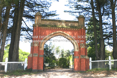 Eltham District Historical Society Inc
Photograph - Digital Photograph, Alan King, Memorial Arch Gateway, Nillumbik Cemetery, Diamond Creek, 23 January 2008
... The barn stood at the corner of Phipps Crescent and the main road.4 Former Eltham Shire councillor George Stebbings, who died in 1896, built several prominent buildings in the district, including Shillinglaw Cottage in Eltham.5 The grave of miner James Joseph Whyte, who died in 1908, is a reminder of Diamond Creek’s gold mining history. At age 51, Whyte died from a rock fall in the Diamond Mine, Diamond Creek. Diamond Creek’s first butcher, Patrick Ryan, became President of the Shire of Heidelberg and Chairman of the Eltham Hurstbridge Railway...The barn stood at the corner of Phipps Crescent and the main road.4 Former Eltham Shire councillor George Stebbings, who died in 1896, built several prominent buildings in the district, including Shillinglaw Cottage in Eltham.5 The grave of miner James Joseph Whyte, who died in 1908, is a reminder of Diamond Creek’s gold mining history. At age 51, Whyte died from a rock fall in the Diamond Mine, Diamond Creek. Diamond Creek’s first butcher, Patrick Ryan, became President of the Shire of Heidelberg and Chairman of the Eltham Hurstbridge Railway ...The Nillumbik Cemetery is of historical, architectural, aesthetic and social significance at a Regional level (North-east Melbourne). The memorial arch is of State significance. Nillumbik Cemetery, which was established in 1867, is of historical and social significance for its association with the early history of Diamond Creek and as a record of the pioneering families of the district. Significant graves include those of the famous writer Alan Marshall, author of 'I Can Jump Puddles', footballer Gordon Coventry, and William Ellis, notable early settler and benefactor. The 1897 Tudor/Gothic revival memorial arch, bequeathed by William Ellis, is a rare design in ornamental gateways and is relatively large for the size of the cemetery. It is unique in Victoria as a cemetery gateway arch. The burial ground has associated structures, such as the hexagonal timber sexton's office, post and wire fence and picket hand gate along Main Street, all probably built in the early twentieth century. Covered under Heritage Overlay, Nillumbik Planning Scheme. National Trust of Australia (Victoria) - Regional significance Published: Nillumbik Now and Then / Marguerite Marshall 2008; photographs Alan King with Marguerite Marshall.; p83 Entering Nillumbik Cemetery through an ornamental gateway and shaded by the Monterey Cypress hedge helps one leave the busy world outside and contemplate yesterday’s Diamond Creek. The gateway, classified by the National Trust of Australia (Victoria), and inscribed with ‘JANVA VITAE’ (gate of life), was a gift from a distinguished pioneer, William Ellis. Ellis, who was an original trustee of the Nillumbik Cemetery representing the Primitive Methodists and a successful farmer, bequeathed £100 to build the red-brick and carved stone gateway in 1887. In 1867 surveyor Edward Bage had set aside two acres (0.8ha) now 35 Main Street, for this cemetery, in what was then called the village of Nillumbik. Several earlier burials on private lands in the district might have been exhumed and re-interred in the new cemetery. The first burials in the cemetery are thought to be of ‘a Chinaman who hanged himself from a tree behind the Church of England’ and ‘another man who was drowned in a water-hole behind the same church’.1 The 1000 or so graves in the cemetery are grouped into five denominational sections: two Anglican and one each for the Methodist (the largest), Catholic and Presbyterian Churches. It is believed that several unmarked graves are of Aborigines and Chinese miners.2 Perhaps the most famous person buried in the cemetery was author Alan Marshall, who died in 1984 and wrote, among other books, I Can Jump Puddles. Surprisingly his grave is particularly modest consisting of only a grassed plot with a tiny boulder and a simple bronze plaque. It lies about halfway down the main path, at the west and third row back. The first European, interred at the cemetery on July 9, 1869, was Hannah, aged 13 years eight months, daughter of local orchardist John Lawrey and wife Honor.3 Each grave has a story which reflects a rich history. Phillip Cummings, who died in 1884, provided the barn for Diamond Creek’s first school, run by the Primitive Methodist Church. The barn stood at the corner of Phipps Crescent and the main road.4 Former Eltham Shire councillor George Stebbings, who died in 1896, built several prominent buildings in the district, including Shillinglaw Cottage in Eltham.5 The grave of miner James Joseph Whyte, who died in 1908, is a reminder of Diamond Creek’s gold mining history. At age 51, Whyte died from a rock fall in the Diamond Mine, Diamond Creek. Diamond Creek’s first butcher, Patrick Ryan, became President of the Shire of Heidelberg and Chairman of the Eltham Hurstbridge Railway Trust. A former gold miner, he was grandfather of local historian Reverend Jock Ryan. He was buried in an unmarked grave halfway down the central path. His son John Lawrence, who is buried elsewhere, had been a Mayor of the City of Heidelberg. George Martin Pizzey gave a hall, for what was to become The St John’s Anglican Church in Diamond Creek. He was a Crimean War veteran, mason and leather goods manufacturer in Melbourne, who died in 1915. The two world wars took a heavy toll of locals with 54 personnel buried here, two thirds of whom served in World War One. A sporting pioneer was Greensborough District Cricket Club founder, Andrew Webb, who was buried in 1971. Politician Roy Mountford Vale (Monte), who died in 1977, was a Member of the Legislative Assembly of Greensborough, and a founding councillor and president of the Diamond Valley Shire. Modern-day residents are also remembered in this cemetery. The tragic Ash Wednesday bushfires took their toll on the district: William Marsden of Panton Hill CFA died, aged 39, fighting bushfires at Upper Beaconsfield in 1983.6 Several graves tell of those who held distinguished positions overseas, including William Constable, who died in 1989. Constable was artistic director of a ballet company, art director of more than 30 films for London-based film productions, and was awarded best Film Art Director at the Moscow Film Festival in 1960.This collection of almost 130 photos about places and people within the Shire of Nillumbik, an urban and rural municipality in Melbourne's north, contributes to an understanding of the history of the Shire. Published in 2008 immediately prior to the Black Saturday bushfires of February 7, 2009, it documents sites that were impacted, and in some cases destroyed by the fires. It includes photographs taken especially for the publication, creating a unique time capsule representing the Shire in the early 21st century. It remains the most recent comprehenesive publication devoted to the Shire's history connecting local residents to the past. nillumbik now and then (marshall-king) collection, diamond creek, memorial arch, gateway, nillumbik cemetery, william ellis -
Glen Eira Historical Society
Article - Joyous Gard
... Railway... Boyd Park... Wahroonga Crescent...Springthorpe Memorial Boroondara Cemetery Gilbert Web C Gilbert Webb The Wheel of Life Springthorpe John William Inglis Annie Constance Springthorpe Dorothy Springthorpe Annie Constance Springthorpe Enid Springthorpe Lancelot Springthorpe Guy Joyous Gard Doble Allan M Doble Mrs Allan Murrumbeena Primary School Springthorpe Reserve Joyous Gard Court Tyers S W Outer Circle Railway Boyd Park Wahroonga Crescent Murrumbeena Caulfield City Council Boyd’s pottery Linear Park Article Joyous Gard ...Two copies of a one page photocopy from the book Australian Sculptors (1980) by Ken Scarlett, describing the Springthorpe Memorial at Boroondara Cemetery, Kew. The file also includes a photocopy of an article by Chrys Spicer, date and source unknown, about the Springthorpe Memorial. The article includes seven photographs of the memorial. A research note by Chloe Stapleton, dated 31/08/12, suggests a possible source for this article. The file also includes a copy of a typed letter from Allan M Doble to Melbourne University Art Curator Heather Lowe, dated 24/03/1995, concerning the history of the Wheel of Life Sculpture originally located at Joyous Gard. The file also includes a copy of a typed letter, dated 19/05/1995, from Allan Doble to the Melbourne University Gallery with information about the Wheel of Life sculpture Also included in the file are photocopies of two Melway maps showing the location of Joyous Gard and Springthorpe Reserve with notes by Allan Doble, dated 24/03/1995. The file also includes eight coloured photographs (100mm x 150mm) of the Wheel of Life sculpture now located in the Medical School of the University of Melbourne, date and photographer unknown, probably 1990s. Negatives are also included.springthorpe memorial, boroondara cemetery, gilbert web c, gilbert webb, the wheel of life, springthorpe john william, inglis annie constance, springthorpe dorothy, springthorpe annie constance, springthorpe enid, springthorpe lancelot, springthorpe guy, joyous gard, doble allan m, doble mrs allan, murrumbeena primary school, springthorpe reserve, joyous gard court, tyers s w, outer circle railway, boyd park, wahroonga crescent, murrumbeena, caulfield city council, boyd’s pottery, linear park -
 Eltham District Historical Society Inc
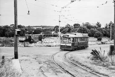
Photograph, Bendigo Tramways No. 7 about to arrive at its terminus in North Bendigo near the intersection of Thunder Street and Moray Crescent, January 1972, Jan 1972
... Bendigo, Bendigo Tramways No. 7, George Coop Collection, Moray Crescent, North Bendigo, railway crossing, Railway Line,Thunder Street, Tram...The tram line proceeds up to the left just pass Moray Crescent where it terminated alongside the railway line in North Bendigo in 1972...Eltham District Historical Society Inc 728 Main Rd Eltham melbourne The tram line proceeds up to the left just pass Moray Crescent where it terminated alongside the railway line in North Bendigo in 1972 Bendigo, Bendigo Tramways No. 7, George Coop Collection, Moray Crescent, North Bendigo, railway crossing, Railway Line,Thunder Street, Tram Digital TIFF file Scan of 35mm Ilford FP3 black and white negative transparency Bendigo Tramways No. 7 about to arrive at its terminus in North Bendigo near the intersection of Thunder Street and Moray Crescent, January 1972 Photograph George Coop George Coop ...The tram line proceeds up to the left just pass Moray Crescent where it terminated alongside the railway line in North Bendigo in 1972Digital TIFF file Scan of 35mm Ilford FP3 black and white negative transparencybendigo, bendigo tramways no. 7, george coop collection, moray crescent, north bendigo, railway crossing, railway line,thunder street, tram -
 Eltham District Historical Society Inc
Photograph, Bendigo Tramways No. 7 departs from Thunder Street in North Bendigo en route to Golden Square, Bendigo, January 1972, Jan 1972
... bendigo, bendigo tramways no. 7, george coop collection, moray crescent, north bendigo, railway crossing, railway line, thunder street, tram...The tram line proceeds up to the left just pass Moray Crescent where it terminated alongside the railway line in North Bendigo in 1972...Eltham District Historical Society Inc 728 Main Rd Eltham melbourne The tram line proceeds up to the left just pass Moray Crescent where it terminated alongside the railway line in North Bendigo in 1972 bendigo, bendigo tramways no. 7, george coop collection, moray crescent, north bendigo, railway crossing, railway line, thunder street, tram Digital TIFF file Scan of 35mm Ilford FP3 black and white negative transparency Bendigo Tramways No. 7 departs from Thunder Street in North Bendigo en route to Golden Square, Bendigo, January 1972 Photograph George Coop George Coop ...The tram line proceeds up to the left just pass Moray Crescent where it terminated alongside the railway line in North Bendigo in 1972Digital TIFF file Scan of 35mm Ilford FP3 black and white negative transparencybendigo, bendigo tramways no. 7, george coop collection, moray crescent, north bendigo, railway crossing, railway line, thunder street, tram -
 Eltham District Historical Society Inc
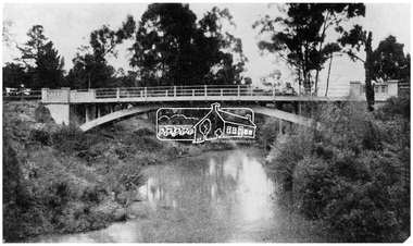
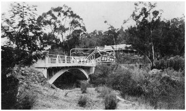
Negative - Photograph, The Bridge, Hurstbridge, Vic, c.1925
... In August 1926, 30 picked allotments of 60x150 feet were put up for auction Saturday August 14, 1926 with frontages to Valley View Road and Fawkner Crescent advertised in the “Heart of the Glorious Wattle Country” and “Within 15 Minutes of the Newly Electrified Railway Station”. ...In August 1926, 30 picked allotments of 60x150 feet were put up for auction Saturday August 14, 1926 with frontages to Valley View Road and Fawkner Crescent advertised in the “Heart of the Glorious Wattle Country” and “Within 15 Minutes of the Newly Electrified Railway Station”. ...Copied from brochure "Wattle Valley Estate" 7 minutes from the bridge. The new bridge designed by Sir John Monash over the Diamond Creek near Hurst's home of 'Mia Mia' at Hurstbridge. The Wattle Valley Estate was first advertised in August 1925 as weekend building allotments by the Greater Melbourne Land and Development Company. Advertised from £28.10.0 or £60 per block. In August 1926, 30 picked allotments of 60x150 feet were put up for auction Saturday August 14, 1926 with frontages to Valley View Road and Fawkner Crescent advertised in the “Heart of the Glorious Wattle Country” and “Within 15 Minutes of the Newly Electrified Railway Station”. The Advertiser on August 13, 1926 in an article promoting the auction stated “the estate is regarded as one of the best in the district, and will be sold practically without reserve.” It is noted that an advertisement running in The Argus February 22, 1951 offered the remaining 16 blocks for sale at £12.10.0 or £200 the lot. By March 7, the remaining blocks were advertised at £17.10.0 The Wattle Valley Estate took over 20 years to sell and then people could not build on them This image was also used in a brochure advertising the "Wattle Valley Estate", which forms part of the Shire of Eltham Pioneers Photograph Collection (Cross Reference Photo No.(s): 1056, 1057)This photo forms part of a collection of photographs gathered by the Shire of Eltham for their centenary project book,"Pioneers and Painters: 100 years of the Shire of Eltham" by Alan Marshall (1971). The collection of over 500 images is held in partnership between Eltham District Historical Society and Yarra Plenty Regional Library (Eltham Library) and is now formally known as the 'The Shire of Eltham Pioneers Photograph Collection.' It is significant in being the first community sourced collection representing the places and people of the Shire's first one hundred years.Digital image 4 x 5 inch B&W Negshire of eltham pioneers photograph collection, hurstbridge, bridge, diamond creek (creek), monash bridge, wattle valley estate -
 Eltham District Historical Society Inc
Negative - Photograph, Rose Stereograph Company, The Bridge, Hurstbridge, Vic, c.1925
... In August 1926, 30 picked allotments of 60x150 feet were put up for auction Saturday August 14, 1926 with frontages to Valley View Road and Fawkner Crescent advertised in the “Heart of the Glorious Wattle Country” and “Within 15 Minutes of the Newly Electrified Railway Station”. ...In August 1926, 30 picked allotments of 60x150 feet were put up for auction Saturday August 14, 1926 with frontages to Valley View Road and Fawkner Crescent advertised in the “Heart of the Glorious Wattle Country” and “Within 15 Minutes of the Newly Electrified Railway Station”. ...Copied from brochure "Wattle Valley Estate". The new bridge designed by Sir John Monash over the Diamond Creek near Hurst's original home "Mia Mia" seen in the distance. Reprinted from brochure advertising "Wattle Valley Estate" 7 minutes from bridge. The Wattle Valley Estate was first advertised in August 1925 as weekend building allotments by the Greater Melbourne Land and Development Company. Advertised from £28.10.0 or £60 per block. In August 1926, 30 picked allotments of 60x150 feet were put up for auction Saturday August 14, 1926 with frontages to Valley View Road and Fawkner Crescent advertised in the “Heart of the Glorious Wattle Country” and “Within 15 Minutes of the Newly Electrified Railway Station”. The Advertiser on August 13, 1926 in an article promoting the auction stated “the estate is regarded as one of the best in the district, and will be sold practically without reserve.” It is noted that an advertisement running in The Argus February 22, 1951 offered the remaining 16 blocks for sale at £12.10.0 or £200 the lot. By March 7, the remaining blocks were advertised at £17.10.0 The Wattle Valley Estate took over 20 years to sell and then people could not build on them This image was also used in a brochure advertising the "Wattle Valley Estate", which forms part of the Shire of Eltham Pioneers Photograph Collection (Cross Reference Photo No.(s): 1056, 1057). Also cross reference SEPP_1028 / 29 for other views of Mia Mia. Part of a slide show presentation "Bridges & Waterways of the Shire" by Russell Yeoman to the 13 September 1989 Society meeting. The presentation included slides of historic photos from the Shire of Eltham Pioneers collections as well as several recent views. This photo forms part of a collection of photographs gathered by the Shire of Eltham for their centenary project book,"Pioneers and Painters: 100 years of the Shire of Eltham" by Alan Marshall (1971). The collection of over 500 images is held in partnership between Eltham District Historical Society and Yarra Plenty Regional Library (Eltham Library) and is now formally known as the 'The Shire of Eltham Pioneers Photograph Collection.' It is significant in being the first community sourced collection representing the places and people of the Shire's first one hundred years.Digital image 4 x 5 inch B&W Negshire of eltham pioneers photograph collection, hurstbridge, mia mia, bridge, diamond creek (creek), monash bridge, wattle valley estate -
 Eltham District Historical Society Inc
Negative - Photograph, Popular Picnicing at Hurstbridge, c.1925
... In August 1926, 30 picked allotments of 60x150 feet were put up for auction Saturday August 14, 1926 with frontages to Valley View Road and Fawkner Crescent advertised in the “Heart of the Glorious Wattle Country” and “Within 15 Minutes of the Newly Electrified Railway Station”. ...In August 1926, 30 picked allotments of 60x150 feet were put up for auction Saturday August 14, 1926 with frontages to Valley View Road and Fawkner Crescent advertised in the “Heart of the Glorious Wattle Country” and “Within 15 Minutes of the Newly Electrified Railway Station”. ...Picnickers enjoying a Sunday outing near the Wattle Valley Estate at Hurstbridge. Copied from brochure "Wattle Valley Estate". It is believed the picture is taken at the northwest corner of the intersection of Wattletree Road and Hurstbridge-Arthurs Creek Road looking southeast towards the township (most likely where the house is located on the property of what is today No. 2 Wattletree Road)- https://goo.gl/maps/VDorwCe1rJJUapjE6 According to a comment by Jean Verso (via @nillumbikcouncil FB page 3 Jan 2020) - "This view is from Wattle Tree Road with Haleys Gully Road to the right and across the creek to William Gray's nursery at Allwood. The building to the far left looks like Dorset House. The building on the left in the middle distance is still there today and has been used for storage and as a stable/tack room for a number of years." The Wattle Valley Estate was first advertised in August 1925 as weekend building allotments by the Greater Melbourne Land and Development Company. Advertised from £28.10.0 or £60 per block. In August 1926, 30 picked allotments of 60x150 feet were put up for auction Saturday August 14, 1926 with frontages to Valley View Road and Fawkner Crescent advertised in the “Heart of the Glorious Wattle Country” and “Within 15 Minutes of the Newly Electrified Railway Station”. The Advertiser on August 13, 1926 in an article promoting the auction stated “the estate is regarded as one of the best in the district, and will be sold practically without reserve.” It is noted that an advertisement running in The Argus February 22, 1951 offered the remaining 16 blocks for sale at £12.10.0 or £200 the lot. By March 7, the remaining blocks were advertised at £17.10.0 The Wattle Valley Estate took over 20 years to sell and then people could not build on them Cross Ref EDHS_02665 Rose Series Postcard P. 4341, "View at Hurstbridge, Vic." Also, other images from sales brochure SEPP_1055 / 1056This photo forms part of a collection of photographs gathered by the Shire of Eltham for their centenary project book,"Pioneers and Painters: 100 years of the Shire of Eltham" by Alan Marshall (1971). The collection of over 500 images is held in partnership between Eltham District Historical Society and Yarra Plenty Regional Library (Eltham Library) and is now formally known as the 'The Shire of Eltham Pioneers Photograph Collection.' It is significant in being the first community sourced collection representing the places and people of the Shire's first one hundred years.Digital image 4 x 5 inch B&W Neg1925, dorset house, fawkner crescent, haleys gully road, hurstbridge, hurstbridge-arthurs creek road, picnic, postcards, shire of eltham pioneers photograph collection, valley view road, wattle valley estate, wattletree road, exhibition yprl 2019-12 -
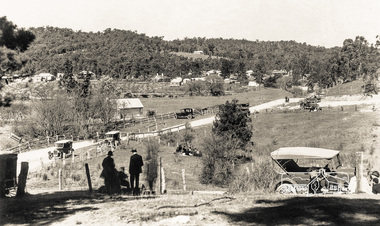 Eltham District Historical Society Inc
Photograph - Postcard, Rose Stereograph Company, View at Hurstbridge, Vic, c.1925
... In August 1926, 30 picked allotments of 60x150 feet were put up for auction Saturday August 14, 1926 with frontages to Valley View Road and Fawkner Crescent advertised in the “Heart of the Glorious Wattle Country” and “Within 15 Minutes of the Newly Electrified Railway Station”. ...In August 1926, 30 picked allotments of 60x150 feet were put up for auction Saturday August 14, 1926 with frontages to Valley View Road and Fawkner Crescent advertised in the “Heart of the Glorious Wattle Country” and “Within 15 Minutes of the Newly Electrified Railway Station”. ...Rose Series Postcard P. 4341 “View at Hurstbridge, Vic.” Picnickers enjoying a Sunday outing near the Wattle Valley Estate at Hurstbridge. Copied from brochure "Wattle Valley Estate". It is believed the picture is taken at the northwest corner of the intersection of Wattletree Road and Hurstbridge-Arthurs Creek Road looking southeast towards the township (most likely where the house is located on the property of what is today No. 2 Wattletree Road)- https://goo.gl/maps/VDorwCe1rJJUapjE6 According to a comment by Jean Verso (via @nillumbikcouncil FB page 3 Jan 2020) - "This view is from Wattle Tree Road with Haleys Gully Road to the right and across the creek to William Gray's nursery at Allwood. The building to the far left looks like Dorset House. The building on the left in the middle distance is still there today and has been used for storage and as a stable/tack room for a number of years." The Wattle Valley Estate was first advertised in August 1925 as weekend building allotments by the Greater Melbourne Land and Development Company. Advertised from £28.10.0 or £60 per block. In August 1926, 30 picked allotments of 60x150 feet were put up for auction Saturday August 14, 1926 with frontages to Valley View Road and Fawkner Crescent advertised in the “Heart of the Glorious Wattle Country” and “Within 15 Minutes of the Newly Electrified Railway Station”. The Advertiser on August 13, 1926 in an article promoting the auction stated “the estate is regarded as one of the best in the district, and will be sold practically without reserve.” It is noted that an advertisement running in The Argus February 22, 1951 offered the remaining 16 blocks for sale at £12.10.0 or £200 the lot. By March 7, the remaining blocks were advertised at £17.10.0 The Wattle Valley Estate took over 20 years to sell and then people could not build on them Cross Ref SEPP_1057, “Popular Picnicing at Hurstbridge” rcopied from Wattle Valley estate sales brochure.Digital file only Postcards scanned from the collection of Michael Aitken on loan to EDHS, 13 Feb 20181925, dorset house, exhibition yprl 2019-12, fawkner crescent, haleys gully road, hurstbridge, hurstbridge-arthurs creek road, michael aitken collection, picnic, postcards, rose stereograph company, shire of eltham pioneers photograph collection, valley view road, wattle valley estate, wattletree road -
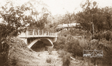 Eltham District Historical Society Inc
Photograph - Postcard, The Bridge, Hurstbridge, Vic
... In August 1926, 30 picked allotments of 60x150 feet were put up for auction Saturday August 14, 1926 with frontages to Valley View Road and Fawkner Crescent advertised in the “Heart of the Glorious Wattle Country” and “Within 15 Minutes of the Newly Electrified Railway Station”. ...In August 1926, 30 picked allotments of 60x150 feet were put up for auction Saturday August 14, 1926 with frontages to Valley View Road and Fawkner Crescent advertised in the “Heart of the Glorious Wattle Country” and “Within 15 Minutes of the Newly Electrified Railway Station”. ...Arched Bridge (Monash Bridge) The Rose Series P. 4036 Reproduced in a brochure advertising the "Wattle Valley Estate" 7 minutes from the bridge. The new bridge designed by Sir John Monash over the Diamond Creek near Hurst's original home "Mia Mia" seen in the distance. The Wattle Valley Estate was first advertised in August 1925 as weekend building allotments by the Greater Melbourne Land and Development Company. Advertised from £28.10.0 or £60 per block. In August 1926, 30 picked allotments of 60x150 feet were put up for auction Saturday August 14, 1926 with frontages to Valley View Road and Fawkner Crescent advertised in the “Heart of the Glorious Wattle Country” and “Within 15 Minutes of the Newly Electrified Railway Station”. The Advertiser on August 13, 1926 in an article promoting the auction stated “the estate is regarded as one of the best in the district, and will be sold practically without reserve.” It is noted that an advertisement running in The Argus February 22, 1951 offered the remaining 16 blocks for sale at £12.10.0 or £200 the lot. By March 7, the remaining blocks were advertised at £17.10.0 The Wattle Valley Estate took over 20 years to sell and then people could not build on them.Digital file only Postcards scanned from the collection of Michael Aitken on loan to EDHS, 13 Feb 2018michael aitken collection, postcards, hurstbridge, monash bridge, bridge, diamond creek (creek), mia mia, shire of eltham pioneers photograph collection, wattle valley estate -
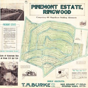 Ringwood and District Historical Society
Poster, Land Sale Advertisement - Pinemont Estate, Ringwood, Victoria - circa 1924
... Crescent, Hygeia Parade, Panorama Avenue, Avalon Grove, Montalbo Road, Cielterre Avenue. Sole Agents T.M. Burke Pty Ltd, 340 Collins Street Melbourne Phones 6294, 6779. Map by S. Callanan, Licensed Surveyor, 107 Elizabeth Street Melbourne. Date of poster estimated from railway...Crescent, Hygeia Parade, Panorama Avenue, Avalon Grove, Montalbo Road, Cielterre Avenue. Sole Agents T.M. Burke Pty Ltd, 340 Collins Street Melbourne Phones 6294, 6779. Map by S. Callanan, Licensed Surveyor, 107 Elizabeth Street Melbourne. Date of poster estimated from railway ...Map of residential allotments for sale, with terms of sale, summary of subdivision features and local services and facilities, and photographs of local street scene and lake (Loughnan's Lake - location not marked), Subdivision includes Wonga Road (later Loughnan's Road), Glenvale Road, Kubba Road, Felix Crescent, Summit Crescent, Pine Crescent, Aurum Crescent, Hygeia Parade, Panorama Avenue, Avalon Grove, Montalbo Road, Cielterre Avenue. Sole Agents T.M. Burke Pty Ltd, 340 Collins Street Melbourne Phones 6294, 6779. Map by S. Callanan, Licensed Surveyor, 107 Elizabeth Street Melbourne. Date of poster estimated from railway services information extract " ... 36 fast electric trains to Flinders Street daily ... proposed electrification to Croydon ..." . Timeline for electrification of Lilydale Line record indicates Box Hill to Ringwood January 1923, Ringwood to Croydon November 1924 (Source: History of Croydon - McGivern, Vol.1 p20).