Showing 547 items matching "railway lines"
-
 Box Hill Historical Society
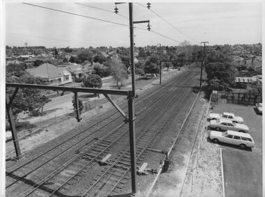
Photograph - Railway lines west of Box Hill Station, 1/10/1975
... Railway lines west of Box Hill Station......Railway lines...Railway lines between Box Hill and Mont Albert looking at the houses in Hopetoun Parade, south of the Railway....Railways Hopetoun Parade Railway lines Black and white photo Photograph Railway lines west of Box Hill Station ...Railway lines between Box Hill and Mont Albert looking at the houses in Hopetoun Parade, south of the Railway.Black and white photorailways, hopetoun parade, railway lines -
 Port Melbourne Historical & Preservation Society
Photograph - Extension of Beach Street, Port Melbourne across railway lines, Ron Laing, c. 1996
... Extension of Beach Street, Port Melbourne across railway lines...A colour photograph of the extension of the new Beach St across the railway lines....Donated to the PMH&PS by the photographer. transport - railways built environment - domestic beacon cove ron laing A colour photograph of the extension of the new Beach St across the railway lines. Photograph Extension of Beach Street, Port Melbourne across railway lines Ron Laing ...Part of Ron Laing's collection of photographs recording Port Melbourne over a thirteen year period. Donated to the PMH&PS by the photographer.A colour photograph of the extension of the new Beach St across the railway lines.transport - railways, built environment - domestic, beacon cove, ron laing -
 Whitehorse Historical Society Inc.
Document, Railway Lines, 01/10/1882
... Railway Lines...Railway Lines...Whitehorse Historical Society Inc. 2-10 Deep Creek Road Mitcham melbourne Railway Lines Lilydale Railway Line 'By Rail to Blackburn' transcribed from Boroondara Standard. ...'By Rail to Blackburn' transcribed from Boroondara Standard.'By Rail to Blackburn' transcribed from Boroondara Standard.'By Rail to Blackburn' transcribed from Boroondara Standard.railway lines, lilydale railway line -
Whitehorse Historical Society Inc.
Article, Railway Lines, 1982
... Railway Lines......Railway Lines...Patterson President of the Nunawading Historical Society. Railway Lines Article Article ...'A Railway and a Boom' by K.A. Patterson President of the Nunawading Historical Society.'A Railway and a Boom' by K.A. Patterson President of the Nunawading Historical Society.'A Railway and a Boom' by K.A. Patterson President of the Nunawading Historical Society.patterson, keith arthur, tile factories, brickworks, railway lines -
Whitehorse Historical Society Inc.
Article, Railway Lines, 17/12/1982 12:00:00 AM
... Railway Lines...Railway Lines...'Camberwell - Lilydale : 100 years old' [Railway] Nunawading Gazette, 17 December 1982. Railway Lines Article Article ...'Camberwell - Lilydale : 100 years old' [Railway] Nunawading Gazette, 17 December 1982.'Camberwell - Lilydale : 100 years old' [Railway] Nunawading Gazette, 17 December 1982.'Camberwell - Lilydale : 100 years old' [Railway] Nunawading Gazette, 17 December 1982.railway lines, box hill railway station -
Port Melbourne Historical & Preservation Society
Audio - 3CR interview with Patrick O'Connor, Public Transport Users Association re Closure of Port Melbourne and St Kilda railway lines, Pat Grainger, 22 Dec 1990
... 3CR interview with Patrick O'Connor, Public Transport Users Association re Closure of Port Melbourne and St Kilda railway lines...Extract from radio 3CR program presented by Bill Hartley, interviewing Patrick O'Connor of the Public Transport Users Association regarding the closure of the Port Melbourne and St Kilda railway lines....Port Melbourne Historical & Preservation Society Port Melbourne Town Hall 333 Bay Street Port Melbourne melbourne Transport Transport - Railways Bill Hartley Patrick O'Connor Duration 00:08:14 Extract from radio 3CR program presented by Bill Hartley, interviewing Patrick O'Connor of the Public Transport Users Association regarding the closure of the Port Melbourne and St Kilda railway lines. Audio 3CR interview with Patrick O'Connor, Public Transport Users Association re Closure of Port Melbourne and St Kilda railway lines Pat Grainger ...Extract from radio 3CR program presented by Bill Hartley, interviewing Patrick O'Connor of the Public Transport Users Association regarding the closure of the Port Melbourne and St Kilda railway lines.Duration 00:08:14transport, transport - railways, bill hartley, patrick o'connor -
 Ringwood and District Historical Society
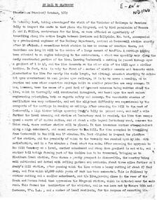
Newspaper - Photograph, Newspaper clipping from 25/07/1957 of photograph taken at railway crossing with railway lines leading to Ringwood Railway Station in 1908
... Newspaper clipping from 25/07/1957 of photograph taken at railway crossing with railway lines leading to Ringwood Railway Station in 1908....Newspaper clipping from Ringwood Mail of 25/07/1957 of photograph taken at railway crossing with railway lines leading to Ringwood Railway Station in 1908....Old newspaper clipping Newspaper clipping from 25/07/1957 of photograph taken at railway crossing with railway lines leading to Ringwood Railway Station in 1908. ...Old newspaper clippingNewspaper clipping from Ringwood Mail of 25/07/1957 of photograph taken at railway crossing with railway lines leading to Ringwood Railway Station in 1908. -
Port Melbourne Historical & Preservation Society
Newspaper - Supplement, CCC Fotographics, Port Melbourne and St Kilda Railway Lines - National Trust Victoria, Nov 1986
... Port Melbourne and St Kilda Railway Lines - National Trust Victoria...Four page National Trust supplement to local paper re Port Melbourne and St Kilda Railway lines, produced for Railway Discovery Day, 30 November 1986 when both lines were threatened with closure...Port Melbourne Historical & Preservation Society Port Melbourne Town Hall 333 Bay Street Port Melbourne melbourne Item from the collection of the late Fred WINDUSS Transport - Railways Celebrations Fetes and Exhibitions National Trust of Victoria Four page National Trust supplement to local paper re Port Melbourne and St Kilda Railway lines, produced for Railway Discovery Day, 30 November 1986 when both lines were threatened with closure Port Melbourne and St Kilda Railway Lines - National Trust Victoria Newspaper Supplement CCC Fotographics Melbourne Times ...Item from the collection of the late Fred WINDUSSFour page National Trust supplement to local paper re Port Melbourne and St Kilda Railway lines, produced for Railway Discovery Day, 30 November 1986 when both lines were threatened with closuretransport - railways, celebrations fetes and exhibitions, national trust of victoria -
 Ringwood and District Historical Society
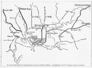
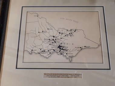
Document, Map of Melbourne suburbs showing proposed new railway lines - 1890
... Map of Melbourne suburbs showing proposed new railway lines - 1890...Typed at bottom of map: "In this map the black lines indicate the proposed new suburban railways. The light lines show the railways already in existence."...Map of Melbourne suburbs showing proposed new railway lines - 1890 Document ...Black and white hand drawn map of Melbourne and some inner suburbs.Typed at bottom of map: "In this map the black lines indicate the proposed new suburban railways. The light lines show the railways already in existence." -
 Melbourne Tram Museum
Newspaper, National Trust, "Port Melbourne and St Kilda Railway Lines" - Rail Discovery Day - Sunday 20 November 1986", Nov. 1986
... "Port Melbourne and St Kilda Railway Lines" - Rail Discovery Day - Sunday 20 November 1986"...Newspaper - four sheets printed on newsprint - National Trust Victoria - titled "Port Melbourne and St Kilda Railway Lines" - Rail Discovery Day - Sunday 20 November 1986", featuring photos and information about the two lines, that at the time was facing closure and conversion to Light Rail. ...Gives the times for the use of a Tait or sliding door train on both lines from Flinders St station "Port Melbourne and St Kilda Railway Lines" - Rail Discovery Day - Sunday 20 November 1986" Newspaper National Trust ...Newspaper - four sheets printed on newsprint - National Trust Victoria - titled "Port Melbourne and St Kilda Railway Lines" - Rail Discovery Day - Sunday 20 November 1986", featuring photos and information about the two lines, that at the time was facing closure and conversion to Light Rail. Notes the National Trust had classified the lines. Gives points of interest along the lines, walks through St Kilda, South Melbourne and Port Melbourne. Gives the times for the use of a Tait or sliding door train on both lines from Flinders St stationtrams, tramways, port melbourne, st kilda, light rail, conversion, national trust, railways -
 Phillip Island and District Historical Society Inc.
Document - leaflet, Proposed Bass Valley, Powlett River and San Remo Railway Lines
... Proposed Bass Valley, Powlett River and San Remo Railway Lines...Page 1-2 appear to be missing Proposed Bass Valley, Powlett River and San Remo Railway Lines Document leaflet ...Submission for the Bass Valley, Powlett River and San Remo Railway line to be included in the Railways Act4 page paper booklet with small print. Pages 3-6. Page 1-2 appear to be missingnon-fictionSubmission for the Bass Valley, Powlett River and San Remo Railway line to be included in the Railways Actrailways, san remo, public transport, bass valley, powlett river -
 Ringwood and District Historical Society
Photograph, Ringwood Railway Station looking west along railway lines, 1918
... Ringwood Railway Station looking west along railway lines, 1918....Ringwood and District Historical Society 125A Warrandyte Road Ringwood North melbourne Ringwood Railway Station looking west 1918 Black and white photograph {2 copies, 1 large, 1 small} Ringwood Railway Station looking west along railway lines, 1918. Photograph ...Black and white photograph {2 copies, 1 large, 1 small}Ringwood Railway Station looking west 1918 -
Whitehorse Historical Society Inc.
Document, Railway Lines, 1919
... Railway Lines...Victorian Railways : Blackburn to Ringwood. Diagram No 7319, showing lines of way ... 1919....Railway Lines Document Document ...Victorian Railways : Blackburn to Ringwood.Victorian Railways : Blackburn to Ringwood. Diagram No 7319, showing lines of way ... 1919.Victorian Railways : Blackburn to Ringwood. victorian railways, railways, blackburn railway station, tunstall railway station, mitcham railway station, ringwood railway station, nunawading railway station -
 Bendigo Historical Society Inc.
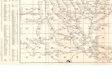
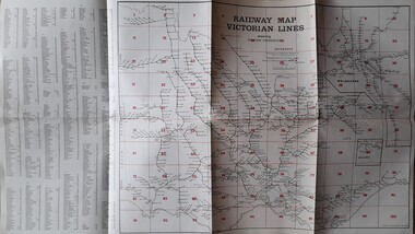
Map - Courtis-Cowling Collection: Railway Map Victorian lines, 1976
... Courtis-Cowling Collection: Railway Map Victorian lines...Laminated map of the Railway lines of Victoria. Printed in black and white and red on cream coloured light-coloured card. ...Map Courtis-Cowling Collection: Railway Map Victorian lines ...Laminated map of the Railway lines of Victoria. Printed in black and white and red on cream coloured light-coloured card. Includes an alphabetical list of all stations in Victoria. Shows station distances. Issued by the Victorian Railways 1976. black lacquer box, snuff, porcelain, courtis -
 Bendigo Historical Society Inc.
Document - RAILWAY MAP: VICTORIAN LINES 1973
... RAILWAY MAP: VICTORIAN LINES 1973...Railway map - Victorian lines 1973 with list of stations and grid reference for location of stations. ...lines and stations. Shows distance from Melbourne (Spencer Street station). Document RAILWAY MAP: VICTORIAN LINES 1973 ...Railway map - Victorian lines 1973 with list of stations and grid reference for location of stations. Inset for detail of Ballarat and Melbourne lines and stations. Shows distance from Melbourne (Spencer Street station).railways, bendigo to melbourne, stations -
 Vision Australia
Map - Object, Victorian railways map
... A black and white map of Victoria showing the railway lines where mail is transported and the individual towns listed next to the dot that provides location of such. ...Paper of Victorian railway lines mounted in frame...Vision Australia 454 Glenferrie Road Kooyong melbourne A black and white map of Victoria showing the railway lines where mail is transported and the individual towns listed next to the dot that provides location of such. ...A black and white map of Victoria showing the railway lines where mail is transported and the individual towns listed next to the dot that provides location of such. Underneath is written "Map of Victoria showing the localities beyond the suburbs of Melbourne to which library books are sent to blind members. Books are carried over the railways FREE there is no charge to the readers." Through the work of Tilly Aston, braille postage was provided free by the Victorian Railways which greatly assisted the Braille Library in reaching members who resided outside of Melbourne. This map was produced to show the extent of the work by the Victorian Association of Braille Writers and the need for reading materials across the state.Paper of Victorian railway lines mounted in framevictorian association of braille writers, marketing -
 Ballarat Heritage Services
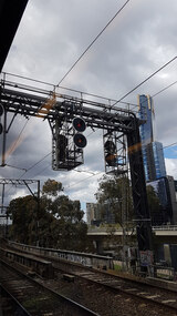
Photograph - Digital photograph, Lisa Gervasoni, Train between Flinders and Spencer Street Stations, 2017
... lines...railway...Colour photograph of railway power lines and signals. ...Ballarat Heritage Services PO Box 2209 Bakery Hill Post Office goldfields melbourne train flinders street spencer street northbank buildings cbd tranmission lines power lines railway Colour photograph of railway power lines and signals. ...Colour photograph of railway power lines and signals. melbourne, train, flinders street, spencer street, northbank, buildings, cbd, tranmission lines, power lines, railway -
 Victorian Railway History Library
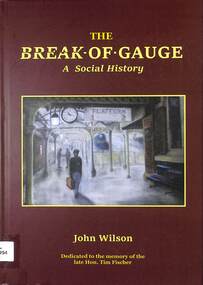
Book, Wilson, John, The Break Of Gauge: A Social History, 2024
... ...SAR LINES Railway Books...The Break Of Gauge: A Social History Book Wilson, John SAR LINES Railway Books ...Tells the story of the gauge problem in Australia, how it happened, why it happened and why there has been faliure to fix the problem and the consequences of the ongoing problem. "From the early days of Australia’s rail networks in the 1850s, different colonies adopted various rail gauges for their own reasons. Even after the Federation on January 1, 1901, the new nation’s leaders missed the chance to create a unified national policy for rail gauges and chose to avoid addressing the issue. This book, generously supported with photographs, timelines, and insights from seasoned rail industry experts, covers a span of 170 years. It examines the political and social attitudes of the time and highlights the missed opportunities to resolve the rail gauge problem dating back to the 1880s."--Publisher's blurb.index, ill, maps, p227.non-fictionTells the story of the gauge problem in Australia, how it happened, why it happened and why there has been faliure to fix the problem and the consequences of the ongoing problem. "From the early days of Australia’s rail networks in the 1850s, different colonies adopted various rail gauges for their own reasons. Even after the Federation on January 1, 1901, the new nation’s leaders missed the chance to create a unified national policy for rail gauges and chose to avoid addressing the issue. This book, generously supported with photographs, timelines, and insights from seasoned rail industry experts, covers a span of 170 years. It examines the political and social attitudes of the time and highlights the missed opportunities to resolve the rail gauge problem dating back to the 1880s."--Publisher's blurb.railroad gauges -- social aspects -- australia -- history, railroad gauges -- australia -- history. -
 Victorian Railway History Library
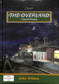
Book, Wilson, John, The Overland A Social History, 2021
... ...SAR LINES Railway Books...Victorian Railway History Library 39 St Edmonds Rd Prahran Prahran Railroad passenger trains - Australia Railroad trains - Overland - history A history of the Overland passenger train from Melbourne to Adelaide index, ill, maps, p.196. The Overland A Social History Book Wilson, John SAR LINES ...A history of the Overland passenger train from Melbourne to Adelaideindex, ill, maps, p.196.non-fictionA history of the Overland passenger train from Melbourne to Adelaiderailroad passenger trains - australia, railroad trains - overland - history -
Glen Eira Historical Society
Letter - Rosstown Railway
... ... Railway Lines...The map includes the names of landholders in the areas of Brighton, Garden Vale and Elsternwick, as well as other railway lines present in the region. 4/A fold-out map and guide of the Rosstown Rail Trail, including a brief general history of Caulfield as well as a more extensive biography of William Murray Ross and the Rosstown Railway. ...Garden Vale Elsternwick Elsternwick Railway Station Rosstown Rosstown Railway Thomas Street Bay Street Kooyong Road Melbourne and Brighton Railway Hawthorn Road Bambra Road Caulfield and Frankston Railway Booran Road Grange Road Koornang Road Murrumbeena Road North Road North Road Railway Station East Brighton Railway Station South Road Railway Routes Railway Lines Railways Land Transport Murphy J. ...This file contains four items: 1/A black and white photocopy of a letter dated either 07/08/1889 or 09/08/1889, from Robert Lundon to an unidentified recipient discussing an agreement reached between the author – on behalf of the recipient – and Soon Hang Hi in regard, in regards to the allotment known as Webber’s. The agreement is outlined in the letter in what appears to be Chinese characters, and includes the marks of Robert Lundon and Soon Hang Hi. File note from Joy Wu states that the calligraphy is not Mandarin or traditional Chinese. 2/Three sheets of hand-written working notes with information taken from the Victorian Government Gazette on THE ROSSTOWN AND MURRUMBEENA LAND COMPANY LIMITED, THE ROSSTOWN JUNCTION RAILWAY AND PROSPERITY COMPANY LIOMITED, and THE ROSSTOWN JUNCTION, ELSTERNWICK, AND OAKLEIGH RAILWAY COMPANY LIMITED, covering dates between 1887 and 1894. The notes concern meetings and creditors claims relevant to the companies, with reference numbers for the information source. Date and author of the notes are not recorded. 3/A black and white photocopy of the a partial map of the Rosstown Railway and surrounding area, undated. The map includes the names of landholders in the areas of Brighton, Garden Vale and Elsternwick, as well as other railway lines present in the region. 4/A fold-out map and guide of the Rosstown Rail Trail, including a brief general history of Caulfield as well as a more extensive biography of William Murray Ross and the Rosstown Railway. The map marks and describes significant sites along the trail, including photographs of some of these sites, provided by DF Jowett.documents, correspondence, webber’s, lundon robert, chinese characters, ethnic communities, signatures, text, settlements, taxes, fraser john grieves, lovell r.h., price davies, meetings, communication activities, soon hang hi, commercial events and activities, the rosstown and murrumbeena land company limited, victorian government gazette, bulmer richard, parry john, osment henry, shareholders, creditors claims, the rosstown junction railway and property company limited, finch and best, lawyers, the rosstown junction elsternwick and oakleigh railway company limited, cameron w.c., phillips p.d., garden vale, elsternwick, elsternwick railway station, rosstown, rosstown railway, thomas street, bay street, kooyong road, melbourne and brighton railway, hawthorn road, bambra road, caulfield and frankston railway, booran road, grange road, koornang road, murrumbeena road, north road, north road railway station, east brighton railway station, south road, railway routes, railway lines, railways, land transport, murphy j., caulfield, hamilton t.f., dane p., holloway, webb, ailee john, payne t.b., brodie chas, dane john, o’neil h., mccombie john, mcmillane a., smyth c.d., cooper, ebden, landholders, jeffrey j.d., gill j., balcombe a.e., cooper h., mcnab j., white j., sutherland j., greeves a.f.a., newton m.c., chamley f.b., fowler j., inglis p., grant t., stooke j., swanson g., cochrane c., adams e.b., mccombie thas, keyes robert, brighton cemetery, burials grounds and graveyards, war-ein road, were j.b., holland j., mcmahon c., winter t.l.m., dendy henry, mitchell w., jackson s., were j.e., wickham francis dawe, bryant jane, east brighton railway station, railway stations, maps, allotments, land titles, roads and streets, rosstown rail trail, city of glen eira, tourism, trains, tourism information bureaus, tours, pamphlets, elsternwick railway park, oakleigh junction, princes park, ee gunn reserve, packer park, sites, jowett d.f., weickhardt i.g., return to rosstown: railways land sales and sugar beet ventures in caulfield, land sales, walking trails, ross william murray, transport objects, locomotion, walking, cycling, driving, sports, country mansions, people, caulfield john, builders, construction and demolition workers, occupations, careers, professionals, topography, geology, landforms, horticulture, market gardens, primary industry workers, city of caulfield, mood kee, pennington harold, annual general meetings, caulfield town hall, glen eira city council, carnegie, carnegie station, rosstown station, people by circumstance, migrants, sugar beet, sugar beet mill, sugar beet industry, mills, factories, sea beach lines, bent thomas, parliamentary representatives, neville street, miller street, lemann’s swamp reserve, koornang park, cane sugar industry, breweries, rabbit processing plants, health establishments, hospitals, food production establishments, abattoirs, thieves, social problems, vagrants, theft, squatting, financial economics, debt, finance industry, insurance companies, company managers, bentleigh, ross leila, the grange, leila road, wild cherry road, financial trouble, mortgages, gisborne street, archibald street, riddell parade, victoria railways, glen huntly road, clarence street, college street, gladstone parade, parrell street, aileen avenue, seaview street, land subdivisions, dover street, sussex street, landfill, marara road, booran road, woodville avenue, dorothy avenue, ormond park, royal avenue, ormond railway station, oakleigh road, melten avenue, miller street, munro avenue, lord reserve, neerim road, toolambool road, the rosstown hotel, rosanna street, murrumbeena crescent, commercial establishments, the national bank, rosstown road, kangaroo road, poath road, freda street, hughesdale kindergarten, oakleigh council, hughesdale community centre, civic establishments, galbally reserve, plaques, warrigal road, out and about brochures, orion estate -
 Hymettus Cottage & Garden Ballarat
Work on paper - Map, Railway Map Victorian Lines
... Railway Map Victorian Lines...Hymettus Cottage & Garden Ballarat 8 Cardigan St Lake Wendouree goldfields Victorian Railways Railway Map Victorian Lines Work on paper Map ...non-fictionvictorian railways -
 Bacchus Marsh & District Historical Society
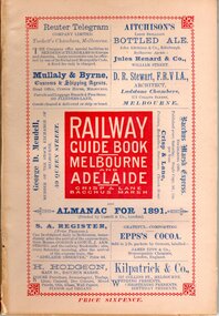
Book, Railway guide book and time table for Melbourne, Ballarat, Adelaide and all intermediate stations, also gazette for Bacchus Marsh, Ballan, Melton, &c., and almanac for 1891
... ...Railway Lines...A copy is held in the State Library of Victoria and also the National Library of Australia. Railways Railway Lines Almanacs Railway Lines Timetables Publication details: 'Railway guide book and time table for Melbourne, Ballarat, Adelaide and all intermediate stations, also gazette for Bacchus Marsh, Ballan, Melton, &c., and almanac for 1891', compiled by Christopher Crisp. ...Publication details: 'Railway guide book and time table for Melbourne, Ballarat, Adelaide and all intermediate stations, also gazette for Bacchus Marsh, Ballan, Melton, &c., and almanac for 1891', compiled by Christopher Crisp. Printed and published by Crisp and Lane, Bacchus Marsh, Vic., 1891. SUMMARY OF CONTENT: Includes detailed timetables and schedule of fares, descriptions of stations and refreshment facilities pp.6-26; overviews of Shires of Bacchus Marsh, Ballan and Melton, pp.27-30; historical, geographic, and economic background notes about places on the Melbourne to Adelaide route, pages 31-64, including descriptions of Bacchus Marsh, pp.34-42 and briefer notes on Ballan, pp.42-43 and Melton, pp.32-33. Almanac section is pp.65-95 (not numbered), containing common information in nineteenth century almanacs such as a calendar of the days, weeks, and months of the year; a record of various astronomical phenomena, climate information and seasonal suggestions for farmers, the rising and setting times of the Sun and Moon, dates of eclipses, hours of high and low tides, and religious festivals. A brief history of Irrigation in Mildura is on pages 1 and 112 (first and last pages). Advertisements, mostly for Bacchus Marsh businesses are on pp.96-111. The Almanac section is illustrated with drawings of scenic views of various places in Australia, but none of the Bacchus Marsh region. Online access is available on Trove at: http://nla.gov.au/nla.obj-392504046Printed book. 112 pages in total. Pages 13 -64 numbered.non-fictionPublication details: 'Railway guide book and time table for Melbourne, Ballarat, Adelaide and all intermediate stations, also gazette for Bacchus Marsh, Ballan, Melton, &c., and almanac for 1891', compiled by Christopher Crisp. Printed and published by Crisp and Lane, Bacchus Marsh, Vic., 1891. SUMMARY OF CONTENT: Includes detailed timetables and schedule of fares, descriptions of stations and refreshment facilities pp.6-26; overviews of Shires of Bacchus Marsh, Ballan and Melton, pp.27-30; historical, geographic, and economic background notes about places on the Melbourne to Adelaide route, pages 31-64, including descriptions of Bacchus Marsh, pp.34-42 and briefer notes on Ballan, pp.42-43 and Melton, pp.32-33. Almanac section is pp.65-95 (not numbered), containing common information in nineteenth century almanacs such as a calendar of the days, weeks, and months of the year; a record of various astronomical phenomena, climate information and seasonal suggestions for farmers, the rising and setting times of the Sun and Moon, dates of eclipses, hours of high and low tides, and religious festivals. A brief history of Irrigation in Mildura is on pages 1 and 112 (first and last pages). Advertisements, mostly for Bacchus Marsh businesses are on pp.96-111. The Almanac section is illustrated with drawings of scenic views of various places in Australia, but none of the Bacchus Marsh region. Online access is available on Trove at: http://nla.gov.au/nla.obj-392504046railways, railway lines, almanacs, railway lines timetables -
 Federation University Historical Collection
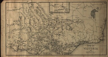
Map, Railway Map of Victoria, 1930
... railway...train-lines...Cardboard map of Victorian railway system in 1930. Maps out all train-lines in Victoria and into New South Wales. ...Barker Library (top floor) Mount Helen goldfields map railway train-lines victoria Victorian Railways railway lines Cardboard map of Victorian railway system in 1930. ...Cardboard map of Victorian railway system in 1930. Maps out all train-lines in Victoria and into New South Wales. map, railway, train-lines, victoria, victorian railways, railway lines -
 Glen Eira Historical Society
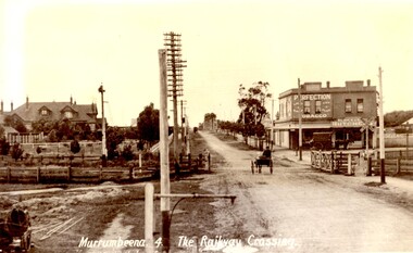
Article - MURRUMBEENA ROAD RAILWAY CROSSING
... ... Railway lines...Murrumbeena Road Carnegie Station Railway lines Railway buildings Road traffic Galatis Gerald Construction sites Poath Road Neerim Road Hermes Studio Article MURRUMBEENA ROAD RAILWAY CROSSING ...This file contains eleven items: 10 original photographs and 1 newspaper cutting. 1/A black and white photograph titled in the format of the shot ‘Murrumbeena. 4. The Railway Crossing’, date unknown, estimated to be 1905. Donated by the Hermes Studio on 19/11/1980. 2/A black and white photograph with a white border of the signal box at Murrumbeena Station by R.P Dunbar dated 16/03/1979 with a handwritten description on the back. 3/A black and white photograph with a white border of the interior of the Murrumbeena Train Station Signal box with a man identified as Michael sitting, taken by R.P Dunbar dated 17/03/1979 with a handwritten description on the back. 4/A black and white photograph with a white border of the removal the boom gates at Murrumbeena Train Station railway crossing. Taken by R.P Dunbar printed 28/04/1979, which includes a handwritten description on the back. 5/A black and white photograph with a white border of the removal of the boom gates taken by R.P Dunbar dated 29/04/1979, with a handwritten description on the back. 6/A black and white photograph with a white border of Murrumbeena Road Crossing during the removal of the boom gates taken by R.P Dunbar printed 29/04/1979. This includes a hand written description on the back. 7/A black and white photograph with a white border of the Murrumbeena Road Railway Crossing during the removal of the boom games dated 29/04/1979, taken by R.P Dunbar, with a hand written description of the photograph on the back. 8/A black and white photograph with a white border of Murrumbeena Road Crossing during the removal of the boom gates dated 29/04/1979 taken by R.P Dunbar with a handwritten description on the back. 9/A black and white photograph with a white border of Murrumbeena Road Railway Crossing with a new boom barrier replacing the boom gates, taken by R.P Dunbar dated 29/04/1979. Including a handwritten description on the back. 10/A black and white photograph with a white border of Murrumbeena Railway Station, Murrumbeena Road with the replacement boom barriers in place, taken by R.P Dunbar dated 29/04/1979. Including a hand written description on the back. 11/A newspaper article titled ‘Boom gates to create road Chaos’ written by Adam Carey from ‘The Age’ dated 29/11/2011. This includes a coloured photograph of the Murrumbeena Road Level Crossing taken by Michael Clayton Jones, and a map of the train line and level crossing between Carnegie Station and Hughesdale Station. The article makes educated predictions based on VicRoads Studies of future implications on road traffic unless more level crossings are removed. In particular the Dandenong corridor and Murrumbeena Road crossings are identified as high priority on the list of potential crossings which may have to be removed. Additionally the article discusses options the government has in addressing the dilemma, and the opinion of a Carnegie pharmacist Gerald Galatis whose business is near the level crossing on Koornang Road.transport, railway crossing, koornang road, railways, level crossing, gates, trains, road crossing, transport establishments, signal boxes, murrumbeena railway station, dunbar r.p., murrumbeena road, carnegie station, railway lines, railway buildings, road traffic, galatis gerald, construction sites, poath road, neerim road, hermes studio -
Glen Eira Historical Society
Article - OUTER CIRCLE RAILWAY
... ... Railway Lines...Outer Circle Railway Normanby Road Caulfield Station Outer Circle Line Rosstown Junction Railway Monash John Caulfield Historical Society Poath Road Deepdene Dasher Ashby Dasher Dandenong Road Gippsy Goods Mallee Root Mercury Outer Circle Railway Reserve Railway Lines Railway Stations Steam Trains Article OUTER CIRCLE RAILWAY ...This file contains five items: 1/Two copies of a document titled THE OUTER CIRCLE RAILWAY by the Royal Historical Society of Victoria and the Australian Railway Historical Society, Vic div. It details the history of the construction of the Outer Circle Railway and discussed expenses and other factors affecting the construction of the line. Notes compiled by R.K Whitehead, Research and Archives Officer Australian Railway Historical Society Victoria Division. The document includes three maps of the outer circle railway line. 2/Four newspaper articles detailing the history of the Outer Circle Railway Line. They include ten black and white images of various aspects of the railway and three line maps. The first article is titled ‘Rail Link with the Past’. In the COLLINGWOOD COURIER dated 07/10/1970, author unknown. The second article titled ‘Ghost trains of the Outer’ by Kenneth Joachim in the HERALD dated 18/04/1975. The third article is titled ‘Tracks in Time’ by Norman Thompson from NEWS, dated 13/02/1973. The fourth article is titled ‘Our Ghost Railway’ by John Townsley from the HERALD, dated 06/11/1974. 3/A letter from Victorian Railways Chief Estate Officer N.A Wigmore to the Honorary Secretary of the Caulfield Historical Society, dated 19/11/1975 regarding the leasing of land along the Outer Circle Railway Reserve from Dandenong Road to the Hughesdale Station. 4/Two copies of an article titled ‘Outer Circle Railway’ in the CAULFIELD HISTORICAL SOCIETY NEWSLETTER undated detailing the history of the outer circle line. The article includes a map of the section of the line in Caulfield. 5/A Photocopy of two images of train line locations on the Outer Circle Line. One on Warrigal Road, looking south from Ashburton dated 1936. The second is of the Black Bridge over Gardiners Creek dated 1935.outer circle railway, normanby road, caulfield station, outer circle line, rosstown junction railway, monash john, caulfield historical society, poath road, deepdene dasher, ashby dasher, dandenong road, gippsy goods, mallee root mercury, outer circle railway reserve, railway lines, railway stations, steam trains -
Glen Eira Historical Society
Article - Rosstown Railway
... ... Railway Lines...Murray Ross Murray Sugar Beet Mills Mills Elsternwick Land Transport Railways Railway Lines Railway Routes Carnegie Neville Street Carnegie Miller Street Factories Market Gardens Horticulture Peat Soils Land Forms Topography Geology Civic Issues Cone Sugar Industry Elsternwick Plaza Elsternwick Glenhuntly Road Parks and Reserves EE Gunn Reserve Caulfield Racecourse Sportsgrounds Caulfield Carnegie Riddell Parade Clarence Street Aileen Avenue Princes Park Dover Street Marara Road Oakleigh Road Rosanna Street Murrumbeena Crescent North Road Kooyong Road Hawthorn Road Booran Road Koornang Road Poath Road Warragul Road Railway Platforms Railway Buildings Bambra Road Swamps Landforms Landfill Council Landfill Railway Bridges Bridges Railway Underpasses Sporting Clubs Tennis Clubs Bowls Clubs Rosstown Railway Rosanna Street Reserve Maps Railway Maps LIVING IN GLEN EIRA Weickhardt Ian Jowett Des Caulfield South Curraweena Road Oakleigh Caulfield Technical School RETURN TO ROSSTOWN Beet Sugar Industry Crops Land Booms Land Development and Subdivisions Bent Thomas Fink Benjamin Sugar Works Rosstown Hotel Oamdenong Road ROSSTOWN DRY CLEANERS Shops Rosstown Road Rosstown Plate People by Circumstance Migrants Accountants Occupations Professionals THE GRANGE Real Estate Grange Road Financial Agents Judges ROSSTOWN ESTATE Financial Trouble Rabbit Preserving Breweries Political Debates Political Issues Political Electorates Politics Political Science Debt Financial Loans Court Procedures Court Cases Legal Events and Activities MALLESON AND RIGGALL Widowers SEABEACH RAILWAY Economics Economic Deadline Depression 1890s Economic Crash Mortgages Divorce Social Problems Poverty Ross Claude Ross Roderick World War 1914-1918 Wars Military History Servicemen AUSTRALIAN FLYING CORPS Engineers Caulfield Council Swagmen Homelessness Glenhuntly Road Glenhuntly Road Tram Woornack Road Leila Road Wild Cherry Road Melten Avenue Illustrations Steam Trains Trains Horse and Cart Horse-drawn Transport Railway Stations Article Rosstown Railway ...This file contains three items: 1/A review of the ROSSTOWN RAIL TRAIL from LIVING IN GLEN EIRA, vol. 11, 2004, Issue 4, no. 25, date and author unknown. The review explains the purpose of the Rail Trail with a brief narrative of the history behind Rosstown Sugar Mill Railway line. Concluding with information on the location of the Trail and the expected time required to walk the entire track included in the review is a map of the Rail Trail, which marks significant sites along the trail with historic pictures. 2/A newspaper article from THE AGE, dated Tuesday 21/10/1980 and written by Iola Matthews, reporting on the circumstances that led to the publication of the book RETURN TO ROSSTOWN written by Des Jowett and Ian Weickhardt. The article begins with a brief biography of the authors before moving into details of the book’s content, providing a further biography of W. Murray Ross which includes information on his financial ventures – particularly the Rosstown Rail – his marriage and children. The article includes a black and white photograph of Weickhardt and Jowett walking along the route of the railway line, an illustration of the Rosstown sugar works and a map of the area surrounding the site of the mill. 3/Three photocopies of a black and white illustration of the Rosstown sugar works from the east, undated and artist unknown.rosstown rail trail, rosstown, ross william, ross w. murray, ross murray, sugar beet mills, mills, elsternwick, land transport, railways, railway lines, railway routes, carnegie neville street, carnegie miller street, factories, market gardens, horticulture, peat, soils, land forms, topography, geology, civic issues, cone sugar industry, elsternwick plaza, elsternwick, glenhuntly road, parks and reserves, ee gunn reserve, caulfield racecourse, sportsgrounds, caulfield, carnegie, riddell parade, clarence street, aileen avenue, princes park, dover street, marara road, oakleigh road, rosanna street, murrumbeena crescent, north road, kooyong road, hawthorn road, booran road, koornang road, poath road, warragul road, railway platforms, railway buildings, bambra road, swamps, landforms, landfill, council landfill, railway bridges, bridges, railway underpasses, sporting clubs, tennis clubs, bowls clubs, rosstown railway, rosanna street reserve, maps, railway maps, living in glen eira, weickhardt ian, jowett des, caulfield south, curraweena road, oakleigh, caulfield technical school, return to rosstown, beet sugar industry, crops, land booms, land development and subdivisions, bent thomas, fink benjamin, sugar works, rosstown hotel, oamdenong road, rosstown dry cleaners, shops, rosstown road, rosstown plate, people by circumstance, migrants, accountants, occupations, professionals, the grange, real estate, grange road, financial agents, judges, rosstown estate, financial trouble, rabbit preserving, breweries, political debates, political issues, political electorates, politics, political science, debt, financial loans, court procedures, court cases, legal events and activities, malleson and riggall, widowers, seabeach railway, economics, economic deadline, depression 1890s, economic crash, mortgages, divorce, social problems, poverty, ross claude, ross roderick, world war 1914-1918, wars, military history, servicemen, australian flying corps, engineers, caulfield council, swagmen, homelessness, glenhuntly road, glenhuntly road tram, woornack road, leila road, wild cherry road, melten avenue, illustrations, steam trains, trains, horse and cart, horse-drawn transport, railway stations -
Glen Eira Historical Society
Railways in Caulfield
... Photographs of various railway lines, gates and stations in Caulfield...Glen Eira Historical Society 965 Glen Huntly Rd Caulfield VIC 3162 melbourne Caulfield Railways Photographs of various railway lines, gates and stations in Caulfield Railways in Caulfield ...Photographs of various railway lines, gates and stations in Caulfieldcaulfield, railways -
 Phillip Island and District Historical Society Inc.
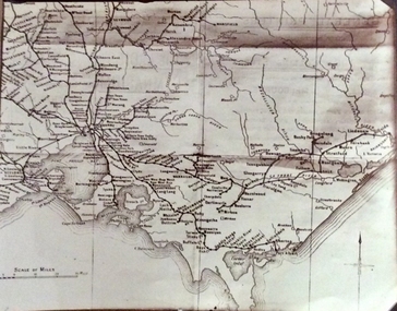
Photograph, Rail Lines of Victoria, Early to mid 20th century
... Sepia photo of map of Victoria showing rivers and railway lines and stations....Phillip Island and District Historical Society Inc. phillip-island-and-the-bass-coast Map showing extensive railway network in Victoria in early C20th. sepia photograph rail transport victoria map Names of towns, rivers, bays etc Sepia photo of map of Victoria showing rivers and railway lines and stations. Rail Lines of Victoria Photograph ...Map showing extensive railway network in Victoria in early C20th.Sepia photo of map of Victoria showing rivers and railway lines and stations.Names of towns, rivers, bays etcsepia photograph, rail transport, victoria, map -
Glen Eira Historical Society
Document - GARDENVALE
... ... Railway lines...Gardenvale Bent Thomas Brighton Caulfield Elsternwick Railway stations Lempriere family ‘Bentville’ Lempriere’s Paddock Market gardens Nepean Highway Nepean Road North Road Kooyong Road Polo Sheridan family Bluestone houses Bethlehem Hospital Land subdivision Begonia Street Gardenia Road Gardenia Street Magnolia Street Lantana Street Martin Street Shops ‘Ben Burb’ House names Padua Hospital Brighton O’Neill Miss O’Neill College O’Neill Richard O’Neill Estate Elster Avenue O’Neill College Estate Railway Crescent Denver Crescent Brentani Avenue College Street Rosstown Railway Brighton Cemetery Ross Mr Hawthorn Road Ormond Gardenvale Progress Association Elster Creek Parliamentary representatives Landscapes Gardenvale Road Railway lines Subways Traders Association Drainage Floods Document GARDENVALE ...This file contains two items about Gardenvale, which was previously all part of Caulfield: 1/Photocopied eight page document by M. Stewart, 1961, entitled ‘The Gardenvale Story’. It describes Gardenvale Railway and surrounding roads and land. Lempriere’s Paddock, rail tracks on the main roads for the use of market gardeners’ wagons. Sale of land for O’Neill College Estate and construction of a subway through the railway embankment to Gardenvale Shopping centre, including efforts by local people and the council for work to be completed and costs. Footnote is circa 1977. 2/Map of Glen Eira printed from Council website 20/06/2014 showing Glen Eira’s share of Gardenvale.gardenvale, bent thomas, brighton, caulfield, elsternwick, railway stations, lempriere family, ‘bentville’, lempriere’s paddock, market gardens, nepean highway, nepean road, north road, kooyong road, polo, sheridan family, bluestone houses, bethlehem hospital, land subdivision, begonia street, gardenia road, gardenia street, magnolia street, lantana street, martin street, shops, ‘ben burb’, house names, padua hospital, brighton, o’neill miss, o’neill college, o’neill richard, o’neill estate, elster avenue, o’neill college estate, railway crescent, denver crescent, brentani avenue, college street, rosstown railway, brighton cemetery, ross mr, hawthorn road, ormond, gardenvale progress association, elster creek, parliamentary representatives, landscapes, gardenvale road, railway lines, subways, traders association, drainage, floods -
Glen Eira Historical Society
Article - Ross, William Murray
... ... Railway lines ...Murray Ross William Ross William Murray Obituaries Caulfield Pioneers ‘The Grange’ Jordan Sergeant Sugar beet Sugar industry Rosstown refinery Rosstown railway Railway lines Elsternwick railway Dandenong road Hawthorn road Inkerman road Local government Caulfield Road Board Pennington Harold Councillor Kooyong Road Glen Eira Road Watts Thomas V.A.T.C. ...This file contains one item: 1/The obituary of William Murray Ross from Brighton Southern Cross, dated 03/09/1904. Ross is commemorated as a pioneer of Caulfield, and the obituary includes a biography recording his life in the area.murray ross william, ross william murray, obituaries, caulfield, pioneers, ‘the grange’, jordan sergeant, sugar beet, sugar industry, rosstown refinery, rosstown railway, railway lines , elsternwick railway, dandenong road, hawthorn road, inkerman road, local government, caulfield road board, pennington harold councillor, kooyong road, glen eira road, watts thomas, v.a.t.c. racecourse, street names, aboriginal languages, caulfield council, lempriere councillor , death and dying, bayston councillor, mayors, brighton southern cross, rosstown, funerals