
Showing 121 items matching "railways - buildings and structures"
-
 Hume City Civic Collection
Photograph, 1990-1999
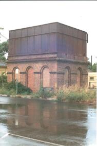
... Two of the railway buildings are visible on either side of the tower....Two of the railway buildings are visible on either side of the tower. ...The photograph is one of a series of 6 which feature the Sunbury Railway Station complex. The complex includes photographs of the railway station with the wooden pedestrian bridge which has been demolished and two photographs of the water towers. The photographs were taken before the railway land on the west side of the line was developed to make way for a supermarket complex in 2000.A view of the brick and iron water tower which is sited on the Bendigo side of the Sunbury Railway Station. The brick structure at the base has 3 arched recesses across the front and two at the side. Two of the railway buildings are visible on either side of the tower.sunbury railway station, water towers, footbridges, bridges, railways, george evans collection -
 Port Melbourne Historical & Preservation Society
Drawing - Various Port Melbourne locations, Brian Cleveland, Brian Cleveland, 1990s
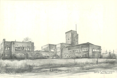
... Sites include: Centenary Bridge (including demolition) ; ships ; Princes Pier ; Station Pier ; structures and cranes on piers ; cable tram sheds ; London Hotel ; foreshore views ; Beacons (leading lights) ; kiosks ; Missions to Seamen building: railway stations....Sites include: Centenary Bridge (including demolition) ; ships ; Princes Pier ; Station Pier ; structures and cranes on piers ; cable tram sheds ; London Hotel ; foreshore views ; Beacons (leading lights) ; kiosks ; Missions to Seamen building: railway stations. ...Brian Cleveland taught art to Swinburne students from the 1970s to 1990s and sketched and recorded iconic areas of the city that were scheduled to vanish or be seriously altered. The Port Melbourne drawings were predominantly done in the 1990sSeventy-two (72)) pencil drawings (some with watercolour washes) by Brian Cleveland. Sites include: Centenary Bridge (including demolition) ; ships ; Princes Pier ; Station Pier ; structures and cranes on piers ; cable tram sheds ; London Hotel ; foreshore views ; Beacons (leading lights) ; kiosks ; Missions to Seamen building: railway stations.built environment, built environment - civic, piers and wharves - princes pier, piers and wharves - station pier, engineering - bridges, brian cleveland, centenary bridge, missions to seamen -
 Sunshine and District Historical Society Incorporated
Administrative record - City of Sunshine - Commissioner Mr Alexander "Alex" George Gillon Collection 1976 - 1982 - Minutes of the ordinary meeting of council held on 22nd August 1978, City of Sunshine, 22nd August 1978
... Minutes of the Ordinary Meeting of Council held on 22nd August 1978 Report of the Town Clerk's Department Report of the Town Clerk Review of Role and Structure of Local Government Federal Finance for Local Government Use of Melbourne & Metropolitan Board of Works Quarters at O'Shannassy, Wallaby Creek and Robertson Land Transfer Discontinued Right of Way Rear of Railway Parade and Wood Street Deer Park Dickson Street Part Private Street Scheme Loan Programme 1978/79 Hulett Street Construction Scheme Report of the Co-Ordinator of Welfare Services Toddler Groups Toddler Group for Children At Risk Social Work Students Maribyrnong Senior Citizens Club Resource Centre / Toy Library Establishment of a Multi-Cultural Senior Citizens Club in Sunshine West Youth Counselling Service Report of the Acting Chief Health Inspector Quarterly Return of Food Samples Keep Australian Beautiful Council Head Lice Campaign Health Act Registrations Application for Transfer of Proprietorship of Premises under the Health Act Annual Inspections Infant Welfare Centres Sewage Overflow 2 Bruce Street Sunshine Report of the Chief By-Laws Officer Removal of Fire Hazards 1978/79 Dog Act Fixing of Registration Fees Report of the City Librarian Bookmobile Maidstone Branch Library Yardley Street to be Closed 29th September and Replaced with Bookmobile Report of the Municipal Recreation Officer Student's Representative Council University of Melbourne Summer School Seminar Multiple Sclerosis Society of Victoria Request for Land Provision of Minibuses for Community Groups Interim Planning Committee Albanvale Primary School Diamond Avenue Reserve Sunshine West High School Community Use Agreement Report of the City Engineer Preferred Development Areas Newmarket Relocation Proposal Planning Permit Application Subdivision and Detached Houses Oakwood Road Town Planning Appeal Planning Permit Application Extension to Factory Graingers Street Sunshine North Planning Permit Application East Side of Hampshire Road North of Existing Sunshine Shopping Cente Generally Bounded by Hampshire Road, Hertford Road, George Street and Service Street Including the Property Occupied by Massey Ferguson Spare Parts Store South of Service Street Rezoning Application Planning Permit Application Service station and Factory 784 Ballarat Road North West Corner Glencairn Avenue Planning Permit Application Warehouse and Workshop Hawthorn Avenue Planning Permit Application Neale Road Subdivision and Detached Houses Town Planning Appeal Home Occupation Three Phase Power Connection 170 Wright Street Planning Permit Flats 17 King Edward Avenue Planning Permit Application Institutional Home Lot 509 Tallintyre Road Planning Permit Application Nursing Home Thompson Street Maidstone Planning Permit Medical Consultation Room South East Corner Percy Street and Main Road East Planning Permit Application Extension to Existing Factory Marshall Street Plan of Subdivision Ballarat Road and Anderson Road Plan of Subdivision Robinsons Road Strata Subdivision Lot 59 Fabian Court Contract Fire Service Sunshine Tip Consolidation of Title Trafalgar Street Employment of Engineering Students for Vocational Training Provision of Footbridge Over Kororoit Creek Reconstruction of South Road Flooding 7th & 8th August 1978 Establishment of Recycling Depot at Sunshine Tip Provision of Spoil for Sunshine Tip Billingham Road Drain Kororoit Creek to Robinsons Road Resitting of Public Telephones Sunshine Road Declaration of Sewage Area No 3550 Footscray West Mail Centre Hampstead Road Closure of Right of Way Between Chicago Street and Chifley Drive Construction of Right of Way Between Randall Street and Barb Street Derelict Cars and Domestic Ferrous Scrap Report of the Building Surveyor 28 - 30 Ridley Street Albion Cancellation of Permit Lot 119 Ballarat Road Application to Build Over Easement 7 Bella Court Sunshine West Application to Build Over Easement 15 Beech Court Sunshine West Building Permit Fees for Council Buildings Report of the Director of Parks & Recreation Bon Thomas Subdivision and Reserve Development Orders of the Day Accounts Submitted for Payment as at 1st July 1978 & 5th August 1978 Proposal to Construct Hulett Street Under The Provisions of Division 10 of Pary XIX of the Local Government Act 1958 Proposal to Construct Dickson Street Under The Provisions of Division 10 of Pary XIX of the Local Government Act 1958 Proposal to Construct Warrs Road (Northern Section) Under The Provisions of Division 10 of Pary XIX of the Local Government Act 1958 Extraordinary Business Report of the Acting Chief Health Officer The Australian Institute of Health Surveyors' 5th National Conference Report of the City Engineer Planning Permit Application Office and Extension of Amenities Building Railway Siding Wright Street Planning Permit Application Car Port Belvedere Close Maribyrnong...Albans Marshall Street Anderson Road Robinsons Road Fabian Court Maribyrnong Sunshine Tip Trafalgar Street Kororoit Creek South Road Braybrook Sunshine Road Tottenham Hampstead Road Chicago Street Chifley Drive Randall Street Barb Street Ridley Street Bella Court Beech Court Bon Thomas Reserve Quinn Street Warrs Road Belvedere Close Minutes of the Ordinary Meeting of Council held on 22nd August 1978 Report of the Town Clerk's Department Report of the Town Clerk Review of Role and Structure of Local Government Federal Finance for Local Government Use of Melbourne & Metropolitan Board of Works Quarters at O'Shannassy, Wallaby Creek and Robertson Land Transfer Discontinued Right of Way Rear of Railway Parade and Wood Street Deer Park Dickson Street Part Private Street Scheme Loan Programme 1978/79 Hulett Street Construction Scheme Report of the Co-Ordinator of Welfare Services Toddler Groups Toddler Group for Children At Risk Social Work Students Maribyrnong Senior Citizens Club Resource Centre / Toy Library Establishment of a Multi-Cultural Senior Citizens Club in Sunshine West Youth Counselling Service Report of the Acting Chief Health Inspector Quarterly Return of Food Samples Keep Australian Beautiful Council Head Lice Campaign Health Act Registrations Application for Transfer of Proprietorship of Premises under the Health Act Annual Inspections Infant Welfare Centres Sewage Overflow 2 Bruce Street Sunshine Report of the Chief By-Laws Officer Removal of Fire Hazards 1978/79 Dog Act Fixing of Registration Fees Report of the City Librarian Bookmobile Maidstone Branch Library Yardley Street to be Closed 29th September and Replaced with Bookmobile Report of the Municipal Recreation Officer Student's Representative Council University of Melbourne Summer School Seminar Multiple Sclerosis Society of Victoria Request for Land Provision of Minibuses for Community Groups Interim Planning Committee Albanvale Primary School Diamond Avenue Reserve Sunshine West High School Community Use Agreement Report of the City Engineer Preferred Development Areas Newmarket Relocation Proposal Planning Permit Application Subdivision and Detached Houses Oakwood Road Town Planning Appeal Planning Permit Application Extension to Factory Graingers Street Sunshine North Planning Permit Application East Side of Hampshire Road North of Existing Sunshine Shopping Cente Generally Bounded by Hampshire Road, Hertford Road, George Street and Service Street Including the Property Occupied by Massey Ferguson Spare Parts Store South of Service Street Rezoning Application Planning Permit Application Service station and Factory 784 Ballarat Road North West Corner Glencairn Avenue Planning Permit Application Warehouse and Workshop Hawthorn Avenue Planning Permit Application Neale Road Subdivision and Detached Houses Town Planning Appeal Home Occupation Three Phase Power Connection 170 Wright Street Planning Permit Flats 17 King Edward Avenue Planning Permit Application Institutional Home Lot 509 Tallintyre Road Planning Permit Application Nursing Home Thompson Street Maidstone Planning Permit Medical Consultation Room South East Corner Percy Street and Main Road East Planning Permit Application Extension to Existing Factory Marshall Street Plan of Subdivision Ballarat Road and Anderson Road Plan of Subdivision Robinsons Road Strata Subdivision Lot 59 Fabian Court Contract Fire Service Sunshine Tip Consolidation of Title Trafalgar Street Employment of Engineering Students for Vocational Training Provision of Footbridge Over Kororoit Creek Reconstruction of South Road Flooding 7th & 8th August 1978 Establishment of Recycling Depot at Sunshine Tip Provision of Spoil for Sunshine Tip Billingham Road Drain Kororoit Creek to Robinsons Road Resitting of Public Telephones Sunshine Road Declaration of Sewage Area No 3550 Footscray West Mail Centre Hampstead Road Closure of Right of Way Between Chicago Street and Chifley Drive Construction of Right of Way Between Randall Street and Barb Street Derelict Cars and Domestic Ferrous Scrap Report of the Building Surveyor 28 - 30 Ridley Street Albion Cancellation of Permit Lot 119 Ballarat Road Application to Build Over Easement 7 Bella Court Sunshine West Application to Build Over Easement 15 Beech Court Sunshine West Building Permit Fees for Council Buildings Report of the Director of Parks & Recreation Bon Thomas Subdivision and Reserve Development Orders of the Day Accounts Submitted for Payment as at 1st July 1978 & 5th August 1978 Proposal to Construct Hulett Street Under The Provisions of Division 10 of Pary XIX of the Local Government Act 1958 Proposal to Construct Dickson Street Under The Provisions of Division 10 of Pary XIX of the Local Government Act 1958 Proposal to Construct Warrs Road (Northern Section) Under The Provisions of Division 10 of Pary XIX of the Local Government Act 1958 Extraordinary Business Report of the Acting Chief Health Officer The Australian Institute of Health Surveyors' 5th National Conference Report of the City Engineer Planning Permit Application Office and Extension of Amenities Building Railway Siding Wright Street Planning Permit Application Car Port Belvedere Close Maribyrnong Foolscap plain paper sheets stapled along the left edge into booklet format. ...Minutes of the Ordinary Meeting of Council held on 22nd August 1978 Report of the Town Clerk's Department Report of the Town Clerk Review of Role and Structure of Local Government Federal Finance for Local Government Use of Melbourne & Metropolitan Board of Works Quarters at O'Shannassy, Wallaby Creek and Robertson Land Transfer Discontinued Right of Way Rear of Railway Parade and Wood Street Deer Park Dickson Street Part Private Street Scheme Loan Programme 1978/79 Hulett Street Construction Scheme Report of the Co-Ordinator of Welfare Services Toddler Groups Toddler Group for Children At Risk Social Work Students Maribyrnong Senior Citizens Club Resource Centre / Toy Library Establishment of a Multi-Cultural Senior Citizens Club in Sunshine West Youth Counselling Service Report of the Acting Chief Health Inspector Quarterly Return of Food Samples Keep Australian Beautiful Council Head Lice Campaign Health Act Registrations Application for Transfer of Proprietorship of Premises under the Health Act Annual Inspections Infant Welfare Centres Sewage Overflow 2 Bruce Street Sunshine Report of the Chief By-Laws Officer Removal of Fire Hazards 1978/79 Dog Act Fixing of Registration Fees Report of the City Librarian Bookmobile Maidstone Branch Library Yardley Street to be Closed 29th September and Replaced with Bookmobile Report of the Municipal Recreation Officer Student's Representative Council University of Melbourne Summer School Seminar Multiple Sclerosis Society of Victoria Request for Land Provision of Minibuses for Community Groups Interim Planning Committee Albanvale Primary School Diamond Avenue Reserve Sunshine West High School Community Use Agreement Report of the City Engineer Preferred Development Areas Newmarket Relocation Proposal Planning Permit Application Subdivision and Detached Houses Oakwood Road Town Planning Appeal Planning Permit Application Extension to Factory Graingers Street Sunshine North Planning Permit Application East Side of Hampshire Road North of Existing Sunshine Shopping Cente Generally Bounded by Hampshire Road, Hertford Road, George Street and Service Street Including the Property Occupied by Massey Ferguson Spare Parts Store South of Service Street Rezoning Application Planning Permit Application Service station and Factory 784 Ballarat Road North West Corner Glencairn Avenue Planning Permit Application Warehouse and Workshop Hawthorn Avenue Planning Permit Application Neale Road Subdivision and Detached Houses Town Planning Appeal Home Occupation Three Phase Power Connection 170 Wright Street Planning Permit Flats 17 King Edward Avenue Planning Permit Application Institutional Home Lot 509 Tallintyre Road Planning Permit Application Nursing Home Thompson Street Maidstone Planning Permit Medical Consultation Room South East Corner Percy Street and Main Road East Planning Permit Application Extension to Existing Factory Marshall Street Plan of Subdivision Ballarat Road and Anderson Road Plan of Subdivision Robinsons Road Strata Subdivision Lot 59 Fabian Court Contract Fire Service Sunshine Tip Consolidation of Title Trafalgar Street Employment of Engineering Students for Vocational Training Provision of Footbridge Over Kororoit Creek Reconstruction of South Road Flooding 7th & 8th August 1978 Establishment of Recycling Depot at Sunshine Tip Provision of Spoil for Sunshine Tip Billingham Road Drain Kororoit Creek to Robinsons Road Resitting of Public Telephones Sunshine Road Declaration of Sewage Area No 3550 Footscray West Mail Centre Hampstead Road Closure of Right of Way Between Chicago Street and Chifley Drive Construction of Right of Way Between Randall Street and Barb Street Derelict Cars and Domestic Ferrous Scrap Report of the Building Surveyor 28 - 30 Ridley Street Albion Cancellation of Permit Lot 119 Ballarat Road Application to Build Over Easement 7 Bella Court Sunshine West Application to Build Over Easement 15 Beech Court Sunshine West Building Permit Fees for Council Buildings Report of the Director of Parks & Recreation Bon Thomas Subdivision and Reserve Development Orders of the Day Accounts Submitted for Payment as at 1st July 1978 & 5th August 1978 Proposal to Construct Hulett Street Under The Provisions of Division 10 of Pary XIX of the Local Government Act 1958 Proposal to Construct Dickson Street Under The Provisions of Division 10 of Pary XIX of the Local Government Act 1958 Proposal to Construct Warrs Road (Northern Section) Under The Provisions of Division 10 of Pary XIX of the Local Government Act 1958 Extraordinary Business Report of the Acting Chief Health Officer The Australian Institute of Health Surveyors' 5th National Conference Report of the City Engineer Planning Permit Application Office and Extension of Amenities Building Railway Siding Wright Street Planning Permit Application Car Port Belvedere Close Maribyrnong city of sunshine, alexander "alex" george gillon, railway parade, wood street, deer park, dickson street, sunshine, hulett street, albion, maribyrnong senior citizens club, multi-cultural senior citizens club, bruce street, maidstone branch library, yardley street, albanvale primary school, diamond avenue reserve, diamond avenue, albanvale, sunshine west high school, lachlan street, sunshine west, oakwood road, graingers street, sunshine north, hampshire road, hertford road, george street, service street, massey ferguson, ballarat road, glencairn avenue, hawthorn avenue, neale road, wright street, king edward avenue, tallintyre road, thompson street, maidstone, percy street, main road east, st. albans, marshall street, anderson road, robinsons road, fabian court, maribyrnong, sunshine tip, trafalgar street, kororoit creek, south road, braybrook, sunshine road, tottenham, hampstead road, chicago street, chifley drive, randall street, barb street, ridley street, bella court, beech court, bon thomas reserve, quinn street, warrs road, belvedere close -
 Flagstaff Hill Maritime Museum and Village
Functional object - Luggage Trolley, Harry Crowther Slingsby, 1930 - 1950
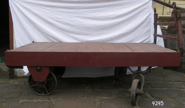
... buildings. Slingsby then set about creating robust trucks and trolleys to move heavy loads with relative ease. Different designs were created for different purposes sack trolleys for moving large sacks of flour, sugar and dried fruit around grocery stores; high wheeled flat carts towed by one or two people; trucks fitted with wicker baskets carried fibers around textile mills and railway platform trolley to move luggage. ...In 1893 Harry Crowther Slingsby founded the company the family firm was at first wholesale bottlers and had established themselves in Bradford, England, later they had a branch in London. Harry Crowther Slingsby began to look into the invention of labor-saving devices for the company. He had recognised that working practices in the local factories relied heavily on manual hauling and gravity for the movement of raw materials and products from floor to floor. However, this did not solve the problem of moving items horizontally around large buildings. Slingsby then set about creating robust trucks and trolleys to move heavy loads with relative ease. Different designs were created for different purposes sack trolleys for moving large sacks of flour, sugar and dried fruit around grocery stores; high wheeled flat carts towed by one or two people; trucks fitted with wicker baskets carried fibers around textile mills and railway platform trolley to move luggage. The company is still in existence today manufacturing many different types of products.An item from the early to mid 20th century connected with railway memorabilia and a company that had humble beginnings to become today a leading UK manufacture. Railway platform luggage trolley large metal frame & wood top with 4 black metal cast iron wheels & metal structure at front with holes to put rope/harness through. Front 2 wheels swivel. Trolley painted red. Wheels are marked Bradford & Londonflagstaff hill, warrnambool, shipwrecked-coast, flagstaff-hill, flagstaff-hill-maritime-museum, maritime-museum, shipwreck-coast, flagstaff-hill-maritime-village -
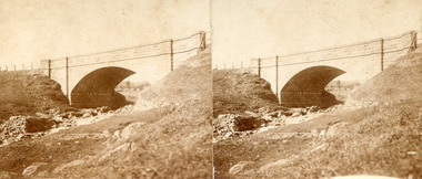 The Beechworth Burke Museum
Photograph - Stereoscopic Photograph, Unknown c1875
... The bridge indicates the growth of the town, replacing a previous timber structure as well as its association to the mining activity in the area and the rapid increase in Australia's economy that led to investment and development of roads and railways. ...The bridge indicates the growth of the town, replacing a previous timber structure as well as its association to the mining activity in the area and the rapid increase in Australia's economy that led to investment and development of roads and railways. ...Depicted in the photograph is Newtown Bridge or the Newtown Falls Bridge, in Beechworth, Victoria. Noted for its location, detailed craftsmanship and stonemasonry by Scottish stonemasons the Newtown Bridge was built in the 19th century provincial town of Beechworth (completed in 1875). The bridge was built over Spring Creek, spanning 6.3 meters wide and 24.8 meters tall. Beechworth held a distinct role in the administrative and commercial management of Victoria's north-eastern goldfields, with many objects and structures still well preserved from the towns establishment. The bridge indicates the growth of the town, replacing a previous timber structure as well as its association to the mining activity in the area and the rapid increase in Australia's economy that led to investment and development of roads and railways. The local granite used in the construction of the single arch Newtown Bridge makes the bridge and other buildings made with the granite unique to the area, the honey-toned material distinct to Beechworth. This photograph is historically significant as it provides insight into the industrial development of Beechworth and the surrounding area, contributed to by the goldfields. The photograph further captures the representation of vernacular engineering traditions and Scottish stonemasonry.Two sepia-toned rectangular photographs featuring a bridge in the background printed on matte photographic paper mounted on card.Reverse: 97.2324/ Newtown Bridge/ Beechworthbridge, newtown beechworth, newtown bridge, newtown, beechworth, beechworth falls bridge, beechworth mining district, spring creek, -
 Federation University Historical Collection
Book, New York Post, The School of Mine Quarterly: A Journal of Applied Science, 1889-1809
... ...structure of the Starch Molecule...The School of Mines Quarterly was a jpournal of Applied Science from Columbia College, New York City. school of mines new york columbia college schools of mines columbia school of mines Witwatersrand Goldfield INter-continental Railway Mine Ropes Harbor improvememnts on the Pacific coast Glycerine and artificial Butter industry Transit Factors for teh Columbia College Observatory Tables for the Reducation of Transit Observations Ancienct methods for dividing and Recoording time in Japan Assay of tin John Strong Newberry Standards of linnear Measure Comparison of costs of electric lighting Huanchaca Mine Bolivia El Callao Gold Mine Venezuela John Magnus Adams Ores in Saxony Hartz and Rhenish Prussia Hofmann Apparatus Adjustment of Trangulation Determination of Carbonic Acid in White Lead Lower Coals in Western Clearfield County Pennsylvania Old Telegraph Mine Ningham Canon Utah mechanical Preparation of Ores modern waterworks construction curdling of milk French regenerative gas furnace Irrication Canals peruvian salt mine Collection of Metallurgic Dust and fume Permeability of iron and steel Assay of Silver Explosion in a Zinc Fume condenser Teaching archtectural history Liquid air between the mine and the smelter Ballistic Galvonometer Assay of Telluride ores Analytical Chemistry Theory and design of the masonry arch silver pick mine Wilson colorado telegraphy and telephoney mineralogy morse code Michigan mining practices Titaniferous magnetites paradox of the pantheon Rocks from Wyoming Witwatersrand goldfields Gaseous sun Alternating current distribution Engineering tests on direct current Electrical Machinery Thomas Egleston Ore dressing Frederick Morgan Watson Camp Bird Gold Mine and Mills Magnetic properties of Iron and Steel Morphology of Organic compounds Antimony structure of the Starch Molecule Cerrillos Hills New Mexico geology Rossie Lead Veins practical electrochemistry lines of graphic statics Anistic Acid by the ozidation of Anniseed Oil Bromate method for antimony John Krom Rees Trust company of America Building Helion lamp Frederick Arthur Goetze Mine Surveying Pine Wood Oils Malleable Cast iron Electrolytic treatment of Galena turpentine and pine oils Bluestone Ashokan Dam bluestone road resistances Oxy-gas blowtorch Mine dumps segregation of steel ingots masonry dam formulas putnam county magnetic belts gases Continuity of education Hydraulic diagrams standardistion of Potassium permanganate Sewerage Discharge into Sea Water Modern waterworks True Column formula Slags from lead furnaces missouri river tempreture of gases rocks architectural history Modern dome oil machine undulations in railway tracks Irrigation engineering Cleps-tachymeters Electrical Engineering New York Shales fan pump Sucrose Isaac Newton French school of anstronomers Electrolytic polarization Benjamin bowden lawrence diamond drilling New York Ciy Water Front Engineering profession ethics The Index to the School of Mines Quarterlu Volumes X1-XX (1900) and 32 green covered journals The School of Mine Quarterly: A Journal of Applied Science Book New York Post ...The School of Mines Quarterly was a jpournal of Applied Science from Columbia College, New York City.The Index to the School of Mines Quarterlu Volumes X1-XX (1900) and 32 green covered journals school of mines, new york, columbia college, schools of mines, columbia school of mines, witwatersrand goldfield, inter-continental railway, mine ropes, harbor improvememnts on the pacific coast, glycerine and artificial butter industry, transit factors for teh columbia college observatory, tables for the reducation of transit observations, ancienct methods for dividing and recoording time in japan, assay of tin, john strong newberry, standards of linnear measure, comparison of costs of electric lighting, huanchaca mine bolivia, el callao gold mine venezuela, john magnus adams, ores in saxony, hartz and rhenish prussia, hofmann apparatus, adjustment of trangulation, determination of carbonic acid in white lead, lower coals in western clearfield county pennsylvania, old telegraph mine ningham canon utah, mechanical preparation of ores, modern waterworks construction, curdling of milk, french regenerative gas furnace, irrication canals, peruvian salt mine, collection of metallurgic dust and fume, permeability of iron and steel, assay of silver, explosion in a zinc fume condenser, teaching archtectural history, liquid air, between the mine and the smelter, ballistic galvonometer, assay of telluride ores, analytical chemistry, theory and design of the masonry arch, silver pick mine wilson colorado, telegraphy and telephoney, mineralogy, morse code, michigan mining practices, titaniferous magnetites, paradox of the pantheon, rocks from wyoming, witwatersrand goldfields, gaseous sun, alternating current distribution, engineering tests on direct current electrical machinery, thomas egleston, ore dressing, frederick morgan watson, camp bird gold mine and mills, magnetic properties of iron and steel, morphology of organic compounds, antimony, structure of the starch molecule, cerrillos hills new mexico, geology, rossie lead veins, practical electrochemistry, lines of graphic statics, anistic acid by the ozidation of anniseed oil, bromate method for antimony, john krom rees, trust company of america building, helion lamp, frederick arthur goetze, mine surveying, pine wood oils, malleable cast iron, electrolytic treatment of galena, turpentine and pine oils, bluestone, ashokan dam bluestone, road resistances, oxy-gas blowtorch, mine dumps, segregation of steel ingots, masonry dam formulas, putnam county magnetic belts, gases, continuity of education, hydraulic diagrams, standardistion of potassium permanganate, sewerage discharge into sea water, modern waterworks, true column formula, slags from lead furnaces, missouri river, tempreture of gases, rocks, architectural history, modern dome, oil machine, undulations in railway tracks, irrigation engineering, cleps-tachymeters, electrical engineering, new york shales, fan pump, sucrose, isaac newton, french school of anstronomers, electrolytic polarization, benjamin bowden lawrence, diamond drilling, new york ciy water front, engineering profession ethics -
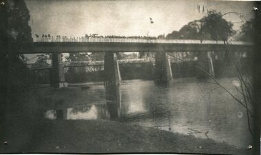 Orbost & District Historical Society
black and white photograph, July 1922
... Railways and the Country Roads Board. Constructed at a cost of 35,000 pounds and used second-hand girders from the Flinders Street- Spencer Street viaduct. On July 4 1922 it was officially opened by Mrs James Cameron. Unfortunately, her husband, who had long championed the building...Railways and the Country Roads Board. Constructed at a cost of 35,000 pounds and used second-hand girders from the Flinders Street- Spencer Street viaduct. On July 4 1922 it was officially opened by Mrs James Cameron. Unfortunately, her husband, who had long championed the building ...A new bridge over the Snowy River at Orbost was opened for traffic on June 20th 1922. It was designed for future joint use by road and railway traffic, but it was only used for road traffic. During the last few years the condition of an old suspension bridge [the 1893 bridge] which was the only vehicular crossing between the town of Orbost and the railway station, caused much concern. The structure was of timber, except for the wire suspension cables of its central span of about 100 feet. A design was prepared in 1914 for a permanent bridge with five spans of 85 feet composed of plate girders on concrete piers. With great increase in the price of steel work during the war, the cost of this design became prohibitive, and the need for a new structure becoming urgent, alternative proposals were investigated. As a result the present design was adopted as providing a sem-permanent bridge at moderate cost. The new bridge spans the river about 160 feet upstream from the old bridge on a slight skew, the piers being at an angle of 80 degrees with the centre line of the bridge. It has a camber of about 2 feet 5 inches in its total length of 527 feet. ( information from Newsletter March 2014 - Lois Crisp) The photograph shows Mrs James Cameron cutting the ribbon at the opening of the Orbost Pile Bridge in 1922. This second bridge, was built by the Victorian Railways and the Country Roads Board. Constructed at a cost of 35,000 pounds and used second-hand girders from the Flinders Street- Spencer Street viaduct. On July 4 1922 it was officially opened by Mrs James Cameron. Unfortunately, her husband, who had long championed the building of the bridge so that it would be ready for the railway to continue to the border, was too ill to attend the ceremony. In fact, James Cameron died on July 13 after a long and severe illness (ref. S.R.M. 20.7.1922). There is a section of this ribbon in the collection - Registration No. 366. This is a pictorial record of a significant event in Orbost's history.A black / white photograph of a pile bridge with a suspension bridge behind it. There are many people standing on the bridge.on back - "Opening of Pile Bridge - 1922"snowy-river-bridge ceremonies cameron-mrs -
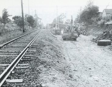 Ringwood and District Historical Society
Photograph, Duplication of the five-kilometre section of railway line between Ringwood and Croydon in 1983
... buildings and a new platform at Croydon, provision of boom barriers, and pedestrian boom barriers at Dublin Road level crossing. East Ringwood, and replacement of existing timber overhead wire support structures with steel structures. Other works in this program included installation of boom barriers at Bedford Road, Ringwood and Scoresby Road, Bayswater and provision of a new platform for trains going to Melbourne and Heathmont. A new timetable on the Lilydale and Belgrave lines will commence when the Ringwood—Croydon duplication track work is completed.” Digital scan Duplication of the five-kilometre section of railway ...Digital scanFrom Vicrail News magazine, April 1983. “Duplication of the five-kilometre section of line between Ringwood and Croydon is on the way. Several major works will be undertaken over the next few months so the two tracks can be brought into service later this year. Intensive work on this section follows completion of duplication works between Ringwood and Bayswater on the Belgrave line last December. The completion of this 5.17 kilometre section between Ringwood and Bayswater means that this Belgrave line is now duplicated as far out as Ferntree Gully. Commuters using the Belgrave line now have an improved service with the intro duction in January of an additional evening peak train to Upper Ferntree Gully, two additional peak hour services in the morning from both Belgrave and Upper Ferntree Gully, and with the additional tracks delays on one line will not affect trains travelling in the opposite direction. Commenting on the completion of this stretch of track the Minister of Transport, Mr. Crabb, said a further improvement had been made with the commissioning of boom barriers at the Bedford Road level crossing in Ringwood. "The installation is part of the State Government's $9.4 million four-year plan to equip 70 dangerous level crossings throughout the State with boom barriers", he said. Works to be carried out on the Ringwood/ Croydon section include laying of new track, station works at Croydon and installation of boom barriers at East Ringwood. Already completed are bridge works to cater for double tracks at both Mt. Dandenong and Eastfield Roads between Croydon and East Ringwood and construction of an island platform at East Ringwood station. At several locations alignment of the existing track will be slightly relocated. The new line is being constructed with concrete sleepers and heavyweight rails. The existing line will also be reconstructed using these heavy 60kg per metre rails. Engineering works to be completed include installation of overhead wiring necessary to supply power to trains, construction of two new station buildings and a new platform at Croydon, provision of boom barriers, and pedestrian boom barriers at Dublin Road level crossing. East Ringwood, and replacement of existing timber overhead wire support structures with steel structures. Other works in this program included installation of boom barriers at Bedford Road, Ringwood and Scoresby Road, Bayswater and provision of a new platform for trains going to Melbourne and Heathmont. A new timetable on the Lilydale and Belgrave lines will commence when the Ringwood—Croydon duplication track work is completed.” -
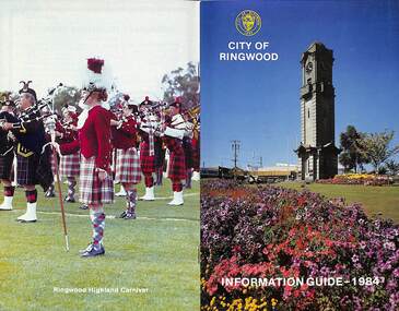 Ringwood and District Historical Society
Booklet, City of Ringwood Information Guide - 1984, 1984
... Building - General Information 23 By-Laws/Traffic Regulations 22 Canterbury Road Railway Bridge Widening 34 Commissioners for Taking Declarations and Affidavits 24 Council Elections 11 Council Representatives 1983/1984 7 Council Structure. 10 Deferment of Rates 11 Emergency Telephone Numbers 59 Employment Initiatives Programme 32 European Wasps 26 Facilities for Disabled Persons 15 From the Chief Executive Officer 8 Garbage 20 Genera] Use Buildings 39 Historical Museum 29 Home Help Service 14 Immunisations - Health Care 12 Immunisation Programme - 1984 13 Justices of the Peace 23 Library Service for Senior Citizens 15 Maintenance of Facilities 34 Management Executive 9 Mayor’s Message – Cr. ...Building - General Information 23 By-Laws/Traffic Regulations 22 Canterbury Road Railway Bridge Widening 34 Commissioners for Taking Declarations and Affidavits 24 Council Elections 11 Council Representatives 1983/1984 7 Council Structure. 10 Deferment of Rates 11 Emergency Telephone Numbers 59 Employment Initiatives Programme 32 European Wasps 26 Facilities for Disabled Persons 15 From the Chief Executive Officer 8 Garbage 20 Genera] Use Buildings 39 Historical Museum 29 Home Help Service 14 Immunisations - Health Care 12 Immunisation Programme - 1984 13 Justices of the Peace 23 Library Service for Senior Citizens 15 Maintenance of Facilities 34 Management Executive 9 Mayor’s Message – Cr. ...Community information booklet issued by City of Ringwood for 1984 - covering the facilities and activities of the Ringwood Council and other local organisations and associations.CONTENTS: (page no.) Building - General Information 23 By-Laws/Traffic Regulations 22 Canterbury Road Railway Bridge Widening 34 Commissioners for Taking Declarations and Affidavits 24 Council Elections 11 Council Representatives 1983/1984 7 Council Structure. 10 Deferment of Rates 11 Emergency Telephone Numbers 59 Employment Initiatives Programme 32 European Wasps 26 Facilities for Disabled Persons 15 From the Chief Executive Officer 8 Garbage 20 Genera] Use Buildings 39 Historical Museum 29 Home Help Service 14 Immunisations - Health Care 12 Immunisation Programme - 1984 13 Justices of the Peace 23 Library Service for Senior Citizens 15 Maintenance of Facilities 34 Management Executive 9 Mayor’s Message – Cr. F.J. Corr 2 Meals on Wheels 14 Members of Parliament 25 Parking Signs and Street Names 35 Pedestrian Hazards 36 Pensioner Rate Assistance Scheme 12 Property Records 11 Rates 11 Re-Cycling of Waste 21 Ringwood Centre (Hostel) for the Frail Aged 17 Ringwood Cultural Centre 40 Ringwood Festival 28 Ringwood Golf Course. 36 Ringwood Highland Carnival 28 Ringwood Lake Reserve 29 Ringwood Library 17 Shopping Centre Studies 38 Staley Gardens 32 Standing Committees of Council 6 Swimming Centre 37 Welfare and Community Services 41 rinx -
 Ringwood and District Historical Society
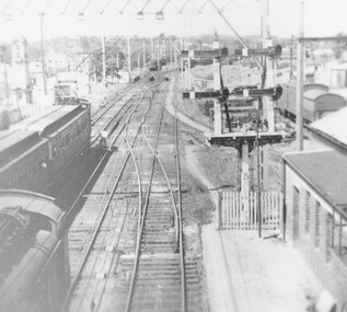
Photograph, Ringwood railway station precinct. Post number 35 in view from the foot bridge. The signalman is giving the staff to the driver of a dog box suburban train, from Bayswater
... Post 35 at that time was a prefab structure which replaced the signal posts knocked down on 22/6/1945. ...Black and White PhotographAccompanying sheet reads, " 'Post 35' shows the scene from the foot bridge. The signalman is giving the staff to the driver of a dog box suburban train, from Bayswater because there is a train probably on arrival Croydon on the Croydon line. The right hand arm of the bracket is off for Bayswater. Post 35 at that time was a prefab structure which replaced the signal posts knocked down on 22/6/1945. The red brick building bottom right corner is the relay room which included devices which would probably have prevented the June 1945 accident". -
Ringwood and District Historical Society
Document, Property Research Notes - The History of 18 Vista Avenue, Ringwood East, Victoria
... The route through the railway crossing on Dublin Road required the removal of the top four feet of roof from the building so it would fit under the overhead wires. ...The route through the railway crossing on Dublin Road required the removal of the top four feet of roof from the building so it would fit under the overhead wires. ...Single A4 page summary of the house and land prepared for real estate purposes by un-named author, undated, circa 1990s.The History Of 18 Vista Avenue, Ringwood East The Land The current block located at 18 Vista Avenue was originally part of an 80 acre block granted to R Blood on 12 March 1872. A Wallace Bruce subsequently sold off a portion of this land and on it the Davies family erected the house "Reaghill" shortly after 1909. A 35 acre parcel of this original block was subdivided into 22 lots in June 1955. The subdivision consisted of 15 lots from 1½ and 2½ acres and seven smaller blocks of about ½ acre fronting Bedford Road. The 18 Vista Avenue block, then just over 2 acres was purchased by Mr Campbell Boyd, a local pharmacist, in 1956. The purchase price was £1000. Mr Boyd became sick not long after acquiring the land and offered the property, then a bush block, to Dr Arthur G Stephens. Dr Stephens purchased the block for £2,500 in 1959. The block was not immediately built on. Dr and Mrs Stephens said they were not able to afford a new building on the Vista Avenue block at the time, so relocated their house from 302 Maroondah Highway, near the current site of the Maroondah City Council, to the current location on the block. The garden design was created by Gloria Parker from Park Orchards and included a variety of roses and unusual species of plants. The House The house which was built in 1959, was successfully moved in two pieces in 1972, from Maroondah Highway, under the railway crossing at Ringwood East and up Scenic Avenue. The route through the railway crossing on Dublin Road required the removal of the top four feet of roof from the building so it would fit under the overhead wires. The building was cut along the entrance hall and when put together the join was barely perceptible. The saw cuts on each side of the house when rejoined, were said to have matched exactly. There were originally two brick fireplaces in the house, one in the lounge (an Adams design) and the second in the library. The library fireplace was not reconstructed after the house was relocated. The bricks and bluestone slabs, which form a substantial part of the structure of the formal garden around the house, were salvaged from the demolition of the Burnt Bridge Hotel. Dr Stephens bought 32 truckloads of uncleaned bricks from the demolition contractor for $1 per load. Presumably the demolition contractor had already been paid to demolish, remove and dump the building rubble by the developer of the Burnt Bridge shopping centre and now was able to on-sell the bricks without the cost of disposal. These bricks make up the first three feet of the brick wall which encompasses the secret garden. This wall originally marked the start of a terraced area which extended back to the Vista Avenue road frontage. The large bluestone slabs making up most of the steps in the garden were the door steps on the old hotel and the large square roughmade bricks were originally the foundation stones for the stumps of the Burnt Bridge building. The terraced area and land to the south of the tennis court (the current 16A to 16E Vista Avenue) was sold off to Bovis Homes after the nine year covenant expried on the land. -
 Eltham District Historical Society Inc
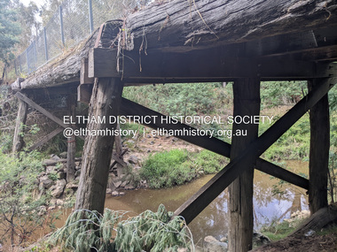
Photograph, Tess Justine (Nillumbik Shire Council), Murray's Bridge over the Diamond Creek, Eltham North, 19 Feb 2022
... It is far more probable that James Murray was hoping to have the railway station located on his property and invested his money by building the bridge to lead to it as well as a station platform. ...It is far more probable that James Murray was hoping to have the railway station located on his property and invested his money by building the bridge to lead to it as well as a station platform. ...Murray's Bridge over the Diamond Creek on the Diamond Creek Trail just prior to demolition and replacement with a new steel bridge. Heritage advice obtained by Nillumbik Shire Council, following a suggestion by the Eltham District Historical Society (EDHS), is that the original bridge appears to have been a simplified version of the Country Roads Board’s (CRB) standard timber bridge design of the early-to-mid 1920s. In c1990 Murray’s bridge was renovated with three recycled steel girders as part of a bike/pedestrian path in the reserve. During these alterations many parts of the bridge were removed, and some were replaced. Heritage advice indicates the condition of Murray’s bridge is poor. The remaining original parts are all in poor condition, with severe weathering, splitting and rot, especially to the stringers retained on the bridge. Heritage advice is that Murray’s Bridge does not have sufficient significance in the cultural history of the Nillumbik area to warrant inclusion in the Nillumbik Shire Heritage Overlay and also does not have sufficient significance as a rare survivor to warrant inclusion in the Nillumbik Shire Heritage Overlay. There are no indications in the historical record that this site was individually important to the cultural history of this area. EDHS is comfortable with the heritage advice provided to Council and has worked closely on this project with Council. EDHS has suggested some of the removed timbers be used in the vicinity of the bridge for landscaping and possibly seating, so as to retain these remnants close to the site of the original bridge, which is the last old timber bridge along the lower reaches of the Diamond Creek. Mary (Sweeney) Murray and John Wright Murray selected 80 acres, Lot C Section 16 and Lot 5 Section 17 Parish of Nillumbik, under an occupation license in 1866. John died in 1867 and freehold was granted to his son John in 1873. The farm was known as ‘Laurel Hill’. John Junior was an Eltham Shire councillor and sometime president from 1887 up until 1897. He added Lot A Section 16 to the farm in ca1888. John and his younger brother James arranged to rent/purchase Lot B Section 17, across Diamond Creek to the west, in ca1900. It appears that John and James farmed separately for a few years, with a new homestead built for James ad family on the high point of Lot B Section 17 in ca1910. John sold off Lot 5 Section 17 in 1912. When John died in 1912 James took over the land on both sides of the Diamond Creek. The old homestead on the west side of the Creek disappeared. A farm bridge over Diamond Creek from this period may have been located close to the northern boundary of the farm. John Langlands, owner of the farm known as ‘Ihurst’ on the west side of Diamond Creek to the south of the Murray’s land, died in 1907. In 1909 his land was then subdivided into 100 lots to become the ‘Glen Park Estate’. Other similar subdivisions of nineteenth century farms around Eltham in this period included the ‘Franktonia (or Beard’s) Estate’ to the northeast and ‘Bonsack’s Estate’ between Eltham and Greensborough. Soon after the opening of the railway extension line from Eltham to Hurstbridge in 1912, Glen Park and nearby residents including James Murray agitated for a railway station or siding to be located half-way between Eltham and Hurstbridge, so that the Glen Park residents who used the railway daily did not have to walk into the Eltham or Hurstbridge stations. Some believed Coleman’s Corner (opposite Edendale Farm) was an appropriate spot for the platform. James Murray was among those who thought the railway should be located on his land, closer to half-way between Eltham and Hurstbridge stations. The Railways Commissioners warned that the locals would have to fund these works themselves. The Glen Park Estate residents initially had difficulty accessing Eltham by road, with only an old low-level bridge over Diamond Creek at the south end of their estate. A new timber trestle bridge across the creek, now on Wattletree Road, was opened in 1915. Road access to the north was gained in 1927 when the new Murray’s Road, which crossed the Murray’s land, was built. Residents continued to agitate for a Glen Park station. By 1926 the Railways Commissioners’ preferred site was on the Murray’s land. They arranged an estimate of cost of a full-length platform. The estimate was too much for the locals, who in 1928 argued unsuccessfully for a shorter and hence cheaper platform. By 1929 Murray had agreed to donate the land, but the locals would still have to fund the works. Murray decided, unilaterally it would appear, to commence work on a timber trestle road bridge over Diamond Creek to link the new Murray Road to the proposed station. Late in 1929 he stopped work on the bridge, for reasons unknown, but started work again and completed the bridge in 1931. There is no further newspaper evidence of the campaign for the Glen Park station until 1939, when Murray and another local, Mr Maxwell, met the Railways Commissioner. The Glen Park locale now included 45 homes on the west side of the creek and 20 on the Eltham side. Most of the residents used the train every day. The Commissioner remained adamant that only a full-length platform could be built for safety reasons. It appears the campaign dissolved at this point. The increasing move to cars may have had an impact. There is no evidence of Murray’s bridge ever being connected to Murray’s Road, or of it having wide use for any purpose by locals. James Murray died in 1947 and the farm was taken over by his son James (Jim). Jim started to sell off parts of the farm in the 1980s, retaining a few acres around the ca1910 homestead and building a new house there. Recreation reserves were established along the creek. In ca1990 Murray’s bridge was renovated with steel girders as part of a bike/pedestrian path in the reserve. The old farmhouse was demolished in ca2014. * * * A theory posted on local community Facebook groups was that the bridge was built in the 1860s and was built to be more robust than was necessary for the movement of cows from one side of the creek to the other. It was suggested the robustness was necessary to support the weight of gold ore being transferred from a mine on Murray’s land to a railway siding near Murrays Bridge (presumably for transfer and processing at Diamond Creek). Perhaps this may have been one of the motivators for Murray, who really knows? Knowing when mining operations ceased on his land and how that fits the overall timeline would be useful but at the time the bridge was built, local gold production was minimal at best. The known facts are: • The railway line came to Eltham in 1902. • The extension of the railway from Eltham to Hurstbridge was constructed in 1912 so no railway line even existed through Murray's property until 1912 and the Victorian Railways maps at the time show no such siding on Murray’s property. • In 1923 a new company was formed in anticipation of the old Diamond Creek Gold Mine being re-opened. The mine had been previously closed and flooded. It was noted in the press at the time that the mine was within a mile of the railway. Nothing really came of this. • Construction of Murrays Bridge was commenced by James Murray in early 1929 in anticipation of a proposed flag station being nominated on his land, but work ceased shortly afterwards. The proposed flag station was commonly referred to as Glen Park as the residents of the Glen Park Estate wanted Option 1, located near them with the platform adjacent to Colemans corner. This was probably never going to fly as it was virtually in eyesight of Eltham station. Allandale Road was the third option, but the Commissioners' preferred option was No. 2 - on Murray's property. • The Railway Commissioners were not going to finance any such station and the works had to be funded by private landowners and residents, hence Murray investing in this himself. • Murray recommenced work two years later and finished his bridge in 1931 but unfortunately for him, the proposed flag station never eventuated. The bluestone siding you reference may well have been built by Murray as part of the proposed station platform. • Up until then, apart from the Main Road bridge, which was washed away in 1924, virtually all local crossings over the Diamond Creek were low lying bridges – Kaylocks Bridge at Brougham Street, Diamond Street bridge, Glen Park Road bridge. It is expected that Murray also had a low-lying bridge to connect his land either side of the creek. These were all washed away or severely damaged multiple times in the 1920s. Lessons were learnt, and Murrays Bridge appears to have been built in accordance with Country Road Board standards of the time. Flood damage was ongoing, and even more recently constructed raised bridges kept getting washed away, e.g., the new Wattle Tree Road bridge in 1958 just months after completion. Murray’s bridge was reinforced with steel some 30 years ago presumably to provide additional floodwater resistance, given the history of bridges disappearing in floodwaters. • In March 1932 it was reported in the Advertiser that there were still some prospectors operating around Eltham North who apart from further scarring the face of the earth over the previous two years had gained significant experience but little gold - hardly a driving factor for constructing a dedicated railway siding and bridge to transfer gold ore. It is far more probable that James Murray was hoping to have the railway station located on his property and invested his money by building the bridge to lead to it as well as a station platform. Had the station eventuated, it may well have driven up the value of his land for subdivision and new housing estates like the Glen Park Estate. That did not eventuate. Whilst the bridge was indeed old (90 years), the core structure being completed in 1931, it had been modified substantially from original and hence had no significant historic value – i.e., it was not a representative example of its type, construction, and age. Given that the bridge was not worthy of saving, the Eltham District Historical Society with Council’s support, and the Eltham Woodworkers group endeavoured to see what suitable sized timbers were salvageable to fabricate a commemorative seat. Unfortunately, the experts at the Woodworkers group were unable to salvage any suitable length/width timbers to fabricate the seat due to the presence of rot. Last remaining wooden trestle bridge on the Diamond Creek Trail just prior to demolition and replacementBorn digital image (27)diamond creek (creek), diamond creek trail, murrays bridge, ‘laurel hill’, john wright murray, mary (sweeney) murra, john murray jnr, james murray, john langlands, ‘ihurst’, ‘glen park estate’, beard's estate, franktonia, bonsack's estate, glen park estate, glen park railway station -
 Eltham District Historical Society Inc
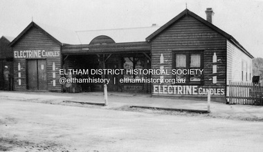
Photograph, Hannah Lloyd's Railway General Store, Main Road, Eltham, c.1917-1920
... Identifier(s): Accession no:H86.93 Subjects: Eltham (Vic.) -- Buildings, structures, etc; Victoria -- History -- 1901-1922; Gelatin silver prints Index terms: Shops; Victoria Notes: Title inscribed in ink on verso. ...Buildings, structures, etc; Victoria -- History -- 1901-1922; Gelatin silver prints Index terms: Shops; Victoria Notes: Title inscribed in ink on verso. Photographer unknown. Undated, date range provided by donor. Contents / Summary: Looking across street towards weatherboard store with porch at doorway, signs painted on front of store read: Electrine Candles. Source / Donor: Gift; Mrs. Nancy Graham; 1986. baker cadburys chocolate cadburys cocoa lloyd's store refreshment room slv shops Copy of sepia photograph Hannah Lloyd's Railway ...Hannah Lloyd's Railway General Store, circa 1917-1920. The store was located just south of opposite Arthur Street at present-day 929-937 Main Road. Note various signs for Electrine Candles, Baker, Cadburys Cocoa, Cadburys Chocolate (in window) and Refreshment Room (faded). This store was the first shop in the present-day Eltham shopping precinct built in 1902 by Luther Haley who operated it from 1902-1917 when it was purchased by Hannah Lloyd and became known as Lloyd’s Railway General Store. Hannah operated it from 1917 to 1920. It then went through a succession of six owners until Eric Staff purchased it in 1939. It remained in the Staff family where it became locally known as Staff’s until Ray Staff sold it in 1965 and it was demolished and replaced with a new a self-service grocery, restaurant and electrical repair shop, the basis of which remains today. The grocery store was the Eltham Big Star Food Centre. To the left of the store one can just catch a glimpse of Edward Gadd’s Coach Building shop situated next door A more extensive history is available on our website at ThrowbackThursday: Eltham Big Star Food Centre, Main Road, 1966 https://elthamhistory.wordpress.com/2020/04/16/throwbackthursday-eltham-big-star-food-centre-main-road-1966/ Edited version of print/digital file sourced from State Library of Victoria: Title: Lloyd's Store, Eltham, [Vic.] [picture]. Date: [ca. 1916-ca. 1922] Description: 1 photographic print : gelatin silver ; 6.6 x 10.8 cm. Copyright status: This work is out of copyright Terms of use: No copyright restrictions apply. Identifier(s): Accession no:H86.93 Subjects: Eltham (Vic.) -- Buildings, structures, etc; Victoria -- History -- 1901-1922; Gelatin silver prints Index terms: Shops; Victoria Notes: Title inscribed in ink on verso. Photographer unknown. Undated, date range provided by donor. Contents / Summary: Looking across street towards weatherboard store with porch at doorway, signs painted on front of store read: Electrine Candles. Source / Donor: Gift; Mrs. Nancy Graham; 1986.Copy of sepia photographbaker, cadburys chocolate, cadburys cocoa, lloyd's store, refreshment room, slv, shops -
 Eltham District Historical Society Inc
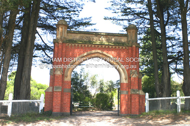
Photograph - Digital Photograph, Alan King, Memorial Arch Gateway, Nillumbik Cemetery, Diamond Creek, 23 January 2008
... The burial ground has associated structures, such as the hexagonal timber sexton's office, post and wire fence and picket hand gate along Main Street, all probably built in the early twentieth century. ...The burial ground has associated structures, such as the hexagonal timber sexton's office, post and wire fence and picket hand gate along Main Street, all probably built in the early twentieth century. ...The Nillumbik Cemetery is of historical, architectural, aesthetic and social significance at a Regional level (North-east Melbourne). The memorial arch is of State significance. Nillumbik Cemetery, which was established in 1867, is of historical and social significance for its association with the early history of Diamond Creek and as a record of the pioneering families of the district. Significant graves include those of the famous writer Alan Marshall, author of 'I Can Jump Puddles', footballer Gordon Coventry, and William Ellis, notable early settler and benefactor. The 1897 Tudor/Gothic revival memorial arch, bequeathed by William Ellis, is a rare design in ornamental gateways and is relatively large for the size of the cemetery. It is unique in Victoria as a cemetery gateway arch. The burial ground has associated structures, such as the hexagonal timber sexton's office, post and wire fence and picket hand gate along Main Street, all probably built in the early twentieth century. Covered under Heritage Overlay, Nillumbik Planning Scheme. National Trust of Australia (Victoria) - Regional significance Published: Nillumbik Now and Then / Marguerite Marshall 2008; photographs Alan King with Marguerite Marshall.; p83 Entering Nillumbik Cemetery through an ornamental gateway and shaded by the Monterey Cypress hedge helps one leave the busy world outside and contemplate yesterday’s Diamond Creek. The gateway, classified by the National Trust of Australia (Victoria), and inscribed with ‘JANVA VITAE’ (gate of life), was a gift from a distinguished pioneer, William Ellis. Ellis, who was an original trustee of the Nillumbik Cemetery representing the Primitive Methodists and a successful farmer, bequeathed £100 to build the red-brick and carved stone gateway in 1887. In 1867 surveyor Edward Bage had set aside two acres (0.8ha) now 35 Main Street, for this cemetery, in what was then called the village of Nillumbik. Several earlier burials on private lands in the district might have been exhumed and re-interred in the new cemetery. The first burials in the cemetery are thought to be of ‘a Chinaman who hanged himself from a tree behind the Church of England’ and ‘another man who was drowned in a water-hole behind the same church’.1 The 1000 or so graves in the cemetery are grouped into five denominational sections: two Anglican and one each for the Methodist (the largest), Catholic and Presbyterian Churches. It is believed that several unmarked graves are of Aborigines and Chinese miners.2 Perhaps the most famous person buried in the cemetery was author Alan Marshall, who died in 1984 and wrote, among other books, I Can Jump Puddles. Surprisingly his grave is particularly modest consisting of only a grassed plot with a tiny boulder and a simple bronze plaque. It lies about halfway down the main path, at the west and third row back. The first European, interred at the cemetery on July 9, 1869, was Hannah, aged 13 years eight months, daughter of local orchardist John Lawrey and wife Honor.3 Each grave has a story which reflects a rich history. Phillip Cummings, who died in 1884, provided the barn for Diamond Creek’s first school, run by the Primitive Methodist Church. The barn stood at the corner of Phipps Crescent and the main road.4 Former Eltham Shire councillor George Stebbings, who died in 1896, built several prominent buildings in the district, including Shillinglaw Cottage in Eltham.5 The grave of miner James Joseph Whyte, who died in 1908, is a reminder of Diamond Creek’s gold mining history. At age 51, Whyte died from a rock fall in the Diamond Mine, Diamond Creek. Diamond Creek’s first butcher, Patrick Ryan, became President of the Shire of Heidelberg and Chairman of the Eltham Hurstbridge Railway Trust. A former gold miner, he was grandfather of local historian Reverend Jock Ryan. He was buried in an unmarked grave halfway down the central path. His son John Lawrence, who is buried elsewhere, had been a Mayor of the City of Heidelberg. George Martin Pizzey gave a hall, for what was to become The St John’s Anglican Church in Diamond Creek. He was a Crimean War veteran, mason and leather goods manufacturer in Melbourne, who died in 1915. The two world wars took a heavy toll of locals with 54 personnel buried here, two thirds of whom served in World War One. A sporting pioneer was Greensborough District Cricket Club founder, Andrew Webb, who was buried in 1971. Politician Roy Mountford Vale (Monte), who died in 1977, was a Member of the Legislative Assembly of Greensborough, and a founding councillor and president of the Diamond Valley Shire. Modern-day residents are also remembered in this cemetery. The tragic Ash Wednesday bushfires took their toll on the district: William Marsden of Panton Hill CFA died, aged 39, fighting bushfires at Upper Beaconsfield in 1983.6 Several graves tell of those who held distinguished positions overseas, including William Constable, who died in 1989. Constable was artistic director of a ballet company, art director of more than 30 films for London-based film productions, and was awarded best Film Art Director at the Moscow Film Festival in 1960.This collection of almost 130 photos about places and people within the Shire of Nillumbik, an urban and rural municipality in Melbourne's north, contributes to an understanding of the history of the Shire. Published in 2008 immediately prior to the Black Saturday bushfires of February 7, 2009, it documents sites that were impacted, and in some cases destroyed by the fires. It includes photographs taken especially for the publication, creating a unique time capsule representing the Shire in the early 21st century. It remains the most recent comprehenesive publication devoted to the Shire's history connecting local residents to the past. nillumbik now and then (marshall-king) collection, diamond creek, memorial arch, gateway, nillumbik cemetery, william ellis -
Glen Eira Historical Society
Article - Grand Union Tramway Junction, Balaclava Road and Hawthorn Road
... Prahran and Malvern Tramways Trust Caulfield Leader Bayside Weekly Tooke Craig Tourist attractions Grand Union Tramways Junction Caulfield Junction Cable Car Tramways Tram shelters Building Sheds Alma Road Orrong Road Caulfield Electric Line Balaclava Junction Elsternwick Railway Station Caulfield station Caulfield Station loop Tram services Transport establishments Thoroughfares Buildings Structures Establishments Parts of buildings or structures Documents Commercial industry Sites Historic sites Melbourne Bayside Weekly Article Grand Union Tramway Junction, Balaclava Road and Hawthorn Road ...This file contains three items. 1. A three-page Caulfield Conservation Study of the Balaclava Road/Hawthorn Road Tramway Crossing, undertake by Andrew Ward and dated September 1994. Study includes a brief history of the junction and a statement of significance. Study also includes Four black and white photographs of the junction and of architectural details of the tram tracks. 2. A letter from the Conservation Manager of the National Trust of Australia (Victoria) to the manager of the Planning Section for the City of Glen Eira, dated 15/06/2001 and attached to a six-page Classification Report. The letter informs of the Classification of the Grand Union Junction at the intersection of Balaclava and Hawthorn Road by the national trust, signed by Conservation Manager Ian Pausacker. Classification Report includes details such as the date of construction, a statement of significance, history of the junction, physical description of the junction and the condition of the junction at the time of writing. Report also includes a map of the Melbourne Tram Network drafted by Keith Kings and dated 01/005/1956, with illustration of the layout of fifteen tram depots, and updated aerial illustration of the Grand Union Junction, and a further map of Melbourne Tramways developed by North Melbourne Electric Tramways and Lighting Co. and Prahran and Malvern Tramways Trust, drafted by Keith Kings and dated January 1914 with illustrations of three tram depots. 3. Two articles from the Caulfield Leader written by Aaron Langmaid and dated 13/02/2007 and the Melbourne Bayside Weekly dated 21/02/2007 written by Joanne Sim, both concerning the Grand Union Junction. The article from the Caulfield Leader includes a picture of Executive Officer of the council of Tramway Museum of Australia Craig Tooke in front of the intersection. The article from the Bayside Weekly includes a picture of a tram passing through the junction and a brief history of the junction and tram network in Caulfield. The article also refers to twp local tram shelters at the intersection of Dandenong Road and Alma Road and also Orrong Road and Balaclava Road.caulfield, caulfield conservation, study, balaclava road, hawthorn road, grand union junction, ward andrew, tramway crossings, transport, acland street, caulfield racecourse, tram tracks, race events, event, tram routes, thorough fares, melbourne and metropolitan tramways board, prahran and malvern tramway trust, prahran and malvern district tramways, caulfield electric tramways, caulfield city council, architectural detail, city of glen eira, balaclava road and hawthorn road intersection, balaclava road and hawthorn road junction, dandenong road, glenhuntly road, four-way tram junctions, access covers darling road, cast metal access covers, hadfields patent, caulfield park, tram systems, tram networks, heritage, tramway heritage, kings keith, tram depots, glenhuntly depot, maps, glen eira, melbourne electric tramways, north melbourne electric tramways and lighting co., prahran and malvern tramways trust, caulfield leader, bayside weekly, tooke craig, tourist attractions, grand union tramways junction, caulfield junction, cable car tramways, tram shelters, building, sheds, alma road, orrong road, caulfield electric line, balaclava junction, elsternwick railway station, caulfield station, caulfield station loop, tram services, transport establishments, thoroughfares, buildings, structures, establishments, parts of buildings or structures, documents, commercial industry, sites, historic sites, melbourne bayside weekly -
 Glen Eira Historical Society
Album - Album page, Hotham Street, Circa 1972
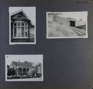
... This bridge forms one of a group of historic structures on the railway to Brighton Beach and therefore contributes to the line's cultural importance as a whole. ...This photograph is part of the Caulfield Historical Album 1972. This album was created in approximately 1972 as part of a project by the Caulfield Historical Society to assist in identifying buildings worthy of preservation. The album is related to a Survey the Caulfield Historical Society developed in collaboration with the National Trust of Australia (Victoria) and Caulfield City Council to identify historic buildings within the City of Caulfield that warranted the protection of a National Trust Classification. Principal photographer thought to be Trevor Hart, member of Caulfield Historical Society. Most photographs were taken between 1966-1972 with a small number of photographs being older and from unknown sources. All photographs are black and white except where stated, with 386 photographs over 198 pages.Victorian Heritage Database - Hotham Street Road Overbridge HO116 Heritage Overlay - City of Glen Eira https://vhd.heritagecouncil.vic.gov.au/places/43557 (as of 04/07/2021) The Hotham Street road overbridge is located on the Sandringham railway line between Ripponlea and Elsternwick railway stations. It is presumed to have been built by contractors Sharp and Campbell who signed a contract on 25th . November, 1881 to construct a second line of railway between Windsor and Elsternwick. This contract was completed during 1882 and the bridge may have been designed in the year when Robert Watson took over from William Elsdon as engineer in chief for the Victorian railways. It is historically, aesthetically and technically significant. It is historically significant (Criterion A) to the extent that it demonstrates the standards of construction adopted by the Victorian Railways Department when it rebuilt the lines acquired from the private railway companies, (compare the Geelong and Melbourne Railway Co's line from Newport to Geelong, acquired in 1860). It is aesthetically significant (Criterion E) as an intact nineteenth century structure of its type, many similar girder bridges having been renewed with concrete girders in recent years. The bluestone abutments demonstrate high standards of stone masonry and are representative of Departmental work of the period. This bridge forms one of a group of historic structures on the railway to Brighton Beach and therefore contributes to the line's cultural importance as a whole. The survival of the riveted iron girders with their bellied angle iron struts is important since these elements are representative of the civil engineering practices of the Victorian Railways at the time and constitute the technical significance (Criterion F) of the structure.Page 96 of Photograph Album with three photographs (one portrait and two landscape) from Hotham Street - two external views of one house and a railway bridge.Handwritten: Hotham Street [top right] / 112 HOTHAM ST [under top left photo] / BRIDGE OVER SANDRINGHAM RAILWAY [under top right photo] / 112 HOTHAM ST CNR MELBY AVE [under bottom left photo] / 96 [bottom right]trevor hart, elsternwick, hotham street, caulfield, houses, brick, bay windows, verandahs, railway bridges, tunnels, gardens, bluestone, civil engineering, victorian railways, sharp and campbell, contractors -
 Eltham District Historical Society Inc
Photograph, George Coop, Elgin Street railway overpass, Hawthorn, c.1962, 1962
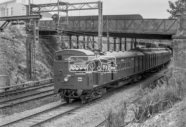
... It is GC's assumption that shortly after the Granville disaster in NSW (18 January 1977) where a train derailment wiped out the bridge supports causing the bridge to collapse and crush the train, that bridges of this kind were replaced to have a single arch bridge structure and that the opportunity was taken when the third line went out the Camberwell, Box Hill, Lilydale lines. ...Looking southwest towards the Burwood Road overpass on the Camberwell line. GC took this photograph as he liked the laciness of the bridge supports. It is GC's assumption that shortly after the Granville disaster in NSW (18 January 1977) where a train derailment wiped out the bridge supports causing the bridge to collapse and crush the train, that bridges of this kind were replaced to have a single arch bridge structure and that the opportunity was taken when the third line went out the Camberwell, Box Hill, Lilydale lines. There are now three lines there. Back then there used to be the old line coming from Hawthorn to Kew across Barkers Road behind Xavier College and into what is now the VicRoads building in the heart of Kew and a single carriage train like the shuttle service between Eltham and Hurstbridge operated on this line.Digital TIFF file Scan of 35mm Ilford FP3 black and white transparency458m, burwood road, camberwell line, elgin road, hawthorn, lilydale line, overpass, red rattler, tait train, -
 Eltham District Historical Society Inc
Photograph, George W. Bell, Eltham South Milk Bar, opposite Eltham Lower Park, c.1960
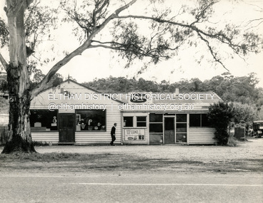
... This building was a different structure. It is not known whether the building was demolished and rebuilt because of this flood event or sometime later to the building seen in this photograph, however it appears to be of a mid-1950s style. ...This building was a different structure. It is not known whether the building was demolished and rebuilt because of this flood event or sometime later to the building seen in this photograph, however it appears to be of a mid-1950s style. ...Site of original tea rooms opposite what was then Eltham Park, now Eltham Lower Park on Main Road, present-day 573 Main Road since early 1970s, immediately prior to which it was 271 Main Road. It is believed a Mrs M Willoughby operated the tea rooms around October 1919. Arthur James McDonald became proprietor of the Eltham Park Tea Rooms some time between 1942 and 1945. In the 1942 Electoral Roll he was recorded living in Moonee Ponds as an aircraft fitter and was then recorded as a tea-room proprietor at Main Road, Eltham in the 1946 Electoral Roll. By 1949 he had moved to Leongatha where he was a café proprietor. A picture of the 1934 floods (EDHS_00103) shows the tea rooms surrounded by waist height flood waters. This building was a different structure. It is not known whether the building was demolished and rebuilt because of this flood event or sometime later to the building seen in this photograph, however it appears to be of a mid-1950s style. During the 1950s it was a milk bar as seen in this photograph and served Devonshire teas in the late 1950s, open only on weekends to service the park and miniature railway opposite. Locals who were children of the late 1950s on recall buying bags of lollies and drinks such as Blue Heaven Spider (ice cream float) and crackers for cracker night. At one point the shop also had pinball machines. It is believed the section of the building to the right was a residence. By the time the Shire of Eltham celebrated its centenary in 1971, the Eltham South Milk Bar was under new management. During the 1980s the shop was operated by Ansell and Muir and they offered takeaway fast food, such as spring rolls and especially hot chicken and chips. Locals also fondly recall their chicken schnitzel with lemon juice. It is remembered as one of the best takeaway food shops, fresh food and fast service with great parking. The residence section to the right was developed as an art, pottery and crafts gallery, Bimbadeen, run by Don Brown, then a local artist. It was taken over in the late 1980s as River Clay run by Leo Haanappel and Coeny Dommers. Unfortunately, the store stood within the 1934 flood zone and the property was unable to be redeveloped. The former Shire of Eltham acquired the land, and the building was subsequently demolished. In December 1993 company registration for Ansell and Muir Prestige Catering was cancelled and the business dissolved. The location is now the site of the current Fleur de Feliss flower stall tent. 17 December 1993 company registration cancelled for Ansell and Muir Prestige Catering Pty. Ltd. [CORPORATIONS LAW Subsection 574(1) (1994, January 12). Commonwealth of Australia Gazette. Periodic (National : 1977 - 2011), p. 20. Retrieved May 24, 2026, from http://nla.gov.au/nla.news-article238039370]Black and white photograph of Eltham South Store later Ansell & Muir c.1960573 main road eltham, 1960, a.j. mcdonald, ansell, ansell and muir, arthur james mcdonald, bimbadeen gallery, eltham, eltham park tea rooms, eltham south, george w. bell collection, main road eltham, milk bar, muir, riverclay craft gallery, shops, take away food -
Port Melbourne Historical & Preservation Society
Photograph - Graham Street overpass, Port Melbourne, Meredith Turnbull, Dec 1996
... Meredith Turnbull photographed this series in 1996 to record the rapidly changing streetscape, which had already had a number of old houses replaced by concrete two-storey structures under the State government's urban consolidation policy Built Environment - Domestic Meredith TURNBULL Evans Street House numbers noted on back From a series of 70 colour photos recording all buildings in Evans Street from Graham Street overpass to Ingles Street, as photographed from the railway reservation, by Meredith Turnbull in December 1996 - Graham Street overpass Photograph Graham Street overpass, Port Melbourne Meredith Turnbull ...Meredith Turnbull photographed this series in 1996 to record the rapidly changing streetscape, which had already had a number of old houses replaced by concrete two-storey structures under the State government's urban consolidation policyFrom a series of 70 colour photos recording all buildings in Evans Street from Graham Street overpass to Ingles Street, as photographed from the railway reservation, by Meredith Turnbull in December 1996 - Graham Street overpassHouse numbers noted on backbuilt environment - domestic, meredith turnbull, evans street -
Port Melbourne Historical & Preservation Society
Photograph - 344 Graham Street, Port Melbourne, Meredith Turnbull, Dec 1996
... Meredith Turnbull photographed this series in 1996 to record the rapidly changing streetscape, which had already had a number of old houses replaced by concrete two-storey structures under the State government's urban consolidation policy Built Environment - Domestic Meredith TURNBULL Evans Street House numbers noted on back From a series of 70 colour photos recording all buildings in Evans Street from Graham Street overpass to Ingles Street, as photographed from the railway reservation, by Meredith Turnbull in December 1996 - 344 Graham Street Photograph 344 Graham Street, Port Melbourne Meredith Turnbull ...Meredith Turnbull photographed this series in 1996 to record the rapidly changing streetscape, which had already had a number of old houses replaced by concrete two-storey structures under the State government's urban consolidation policyFrom a series of 70 colour photos recording all buildings in Evans Street from Graham Street overpass to Ingles Street, as photographed from the railway reservation, by Meredith Turnbull in December 1996 - 344 Graham StreetHouse numbers noted on backbuilt environment - domestic, meredith turnbull, evans street -
Port Melbourne Historical & Preservation Society
Photograph - 7 Evans Street, Port Melbourne, Meredith Turnbull, Dec 1996
... Meredith Turnbull photographed this series in 1996 to record the rapidly changing streetscape, which had already had a number of old houses replaced by concrete two-storey structures under the State government's urban consolidation policy Built Environment - Domestic Meredith TURNBULL Evans Street House numbers noted on back From a series of 70 colour photos recording all buildings in Evans Street from Graham Street overpass to Ingles Street, as photographed from the railway reservation, by Meredith Turnbull in December 1996 - 7 Evans Photograph 7 Evans Street, Port Melbourne Meredith Turnbull ...Meredith Turnbull photographed this series in 1996 to record the rapidly changing streetscape, which had already had a number of old houses replaced by concrete two-storey structures under the State government's urban consolidation policyFrom a series of 70 colour photos recording all buildings in Evans Street from Graham Street overpass to Ingles Street, as photographed from the railway reservation, by Meredith Turnbull in December 1996 - 7 EvansHouse numbers noted on backbuilt environment - domestic, meredith turnbull, evans street -
Port Melbourne Historical & Preservation Society
Photograph - 8 & 9 Evans Street, Port Melbourne, Meredith Turnbull, Dec 1996
... Meredith Turnbull photographed this series in 1996 to record the rapidly changing streetscape, which had already had a number of old houses replaced by concrete two-storey structures under the State government's urban consolidation policy Built Environment - Domestic Meredith TURNBULL Evans Street House numbers noted on back From a series of 70 colour photos recording all buildings in Evans Street from Graham Street overpass to Ingles Street, as photographed from the railway reservation, by Meredith Turnbull in December 1996 - 8 and 9 Evans Photograph 8 & 9 Evans Street, Port Melbourne Meredith Turnbull ...Meredith Turnbull photographed this series in 1996 to record the rapidly changing streetscape, which had already had a number of old houses replaced by concrete two-storey structures under the State government's urban consolidation policyFrom a series of 70 colour photos recording all buildings in Evans Street from Graham Street overpass to Ingles Street, as photographed from the railway reservation, by Meredith Turnbull in December 1996 - 8 and 9 EvansHouse numbers noted on backbuilt environment - domestic, meredith turnbull, evans street -
Port Melbourne Historical & Preservation Society
Photograph - 8, 9 & 11 Evans Street, Port Melbourne, Meredith Turnbull, Dec 1996
... Meredith Turnbull photographed this series in 1996 to record the rapidly changing streetscape, which had already had a number of old houses replaced by concrete two-storey structures under the State government's urban consolidation policy Built Environment - Domestic Meredith TURNBULL Evans Street House numbers noted on back From a series of 70 colour photos recording all buildings in Evans Street from Graham Street overpass to Ingles Street, as photographed from the railway reservation, by Meredith Turnbull in December 1996 - number 8, 9, 11 Evans Photograph 8, 9 & 11 Evans Street, Port Melbourne Meredith Turnbull ...Meredith Turnbull photographed this series in 1996 to record the rapidly changing streetscape, which had already had a number of old houses replaced by concrete two-storey structures under the State government's urban consolidation policyFrom a series of 70 colour photos recording all buildings in Evans Street from Graham Street overpass to Ingles Street, as photographed from the railway reservation, by Meredith Turnbull in December 1996 - number 8, 9, 11 EvansHouse numbers noted on backbuilt environment - domestic, meredith turnbull, evans street -
Port Melbourne Historical & Preservation Society
Photograph - 13 & 14 Evans Street, Port Melbourne, Meredith Turnbull, Dec 1996
... Meredith Turnbull photographed this series in 1996 to record the rapidly changing streetscape, which had already had a number of old houses replaced by concrete two-storey structures under the State government's urban consolidation policy Built Environment - Domestic Meredith TURNBULL Evans Street House numbers noted on back From a series of 70 colour photos recording all buildings in Evans Street from Graham Street overpass to Ingles Street, as photographed from the railway reservation, by Meredith Turnbull in December 1996 - number 13, 14 Photograph 13 & 14 Evans Street, Port Melbourne Meredith Turnbull ...Meredith Turnbull photographed this series in 1996 to record the rapidly changing streetscape, which had already had a number of old houses replaced by concrete two-storey structures under the State government's urban consolidation policyFrom a series of 70 colour photos recording all buildings in Evans Street from Graham Street overpass to Ingles Street, as photographed from the railway reservation, by Meredith Turnbull in December 1996 - number 13, 14House numbers noted on backbuilt environment - domestic, meredith turnbull, evans street -
Port Melbourne Historical & Preservation Society
Photograph - 15 & 17 Evans Street, Port Melbourne, Meredith Turnbull, Dec 1996
... Meredith Turnbull photographed this series in 1996 to record the rapidly changing streetscape, which had already had a number of old houses replaced by concrete two-storey structures under the State government's urban consolidation policy Built Environment - Domestic Meredith TURNBULL Evans Street House numbers noted on back From a series of 70 colour photos recording all buildings in Evans Street from Graham Street overpass to Ingles Street, as photographed from the railway reservation, by Meredith Turnbull in December 1996 - number 15, 17 Photograph 15 & 17 Evans Street, Port Melbourne Meredith Turnbull ...Meredith Turnbull photographed this series in 1996 to record the rapidly changing streetscape, which had already had a number of old houses replaced by concrete two-storey structures under the State government's urban consolidation policyFrom a series of 70 colour photos recording all buildings in Evans Street from Graham Street overpass to Ingles Street, as photographed from the railway reservation, by Meredith Turnbull in December 1996 - number 15, 17House numbers noted on backbuilt environment - domestic, meredith turnbull, evans street -
Port Melbourne Historical & Preservation Society
Photograph - 19 & 20 Evans Street, Port Melbourne, Meredith Turnbull, Dec 1996
... Meredith Turnbull photographed this series in 1996 to record the rapidly changing streetscape, which had already had a number of old houses replaced by concrete two-storey structures under the State government's urban consolidation policy Built Environment - Domestic Meredith TURNBULL Evans Street House numbers noted on back From a series of 70 colour photos recording all buildings in Evans Street from Graham Street overpass to Ingles Street, as photographed from the railway reservation, by Meredith Turnbull in December 1996 - number 19, 20 Photograph 19 & 20 Evans Street, Port Melbourne Meredith Turnbull ...Meredith Turnbull photographed this series in 1996 to record the rapidly changing streetscape, which had already had a number of old houses replaced by concrete two-storey structures under the State government's urban consolidation policyFrom a series of 70 colour photos recording all buildings in Evans Street from Graham Street overpass to Ingles Street, as photographed from the railway reservation, by Meredith Turnbull in December 1996 - number 19, 20House numbers noted on backbuilt environment - domestic, meredith turnbull, evans street -
Port Melbourne Historical & Preservation Society
Photograph - 23 Evans Street, Port Melbourne, Meredith Turnbull, Dec 1996
... Meredith Turnbull photographed this series in 1996 to record the rapidly changing streetscape, which had already had a number of old houses replaced by concrete two-storey structures under the State government's urban consolidation policy Built Environment - Domestic Meredith TURNBULL Evans Street House numbers noted on back From a series of 70 colour photos recording all buildings in Evans Street from Graham Street overpass to Ingles Street, as photographed from the railway reservation, by Meredith Turnbull in December 1996 - number 23 Evans Photograph 23 Evans Street, Port Melbourne Meredith Turnbull ...Meredith Turnbull photographed this series in 1996 to record the rapidly changing streetscape, which had already had a number of old houses replaced by concrete two-storey structures under the State government's urban consolidation policyFrom a series of 70 colour photos recording all buildings in Evans Street from Graham Street overpass to Ingles Street, as photographed from the railway reservation, by Meredith Turnbull in December 1996 - number 23 EvansHouse numbers noted on backbuilt environment - domestic, meredith turnbull, evans street -
Port Melbourne Historical & Preservation Society
Photograph - 27 & 28 Evans Street, Port Melbourne, Meredith Turnbull, Dec 1996
... Meredith Turnbull photographed this series in 1996 to record the rapidly changing streetscape, which had already had a number of old houses replaced by concrete two-storey structures under the State government's urban consolidation policy Built Environment - Domestic Meredith TURNBULL Evans Street House numbers noted on back From a series of 70 colour photos recording all buildings in Evans Street from Graham Street overpass to Ingles Street, as photographed from the railway reservation, by Meredith Turnbull in December 1996 - number 27, 28 Evans Photograph 27 & 28 Evans Street, Port Melbourne Meredith Turnbull ...Meredith Turnbull photographed this series in 1996 to record the rapidly changing streetscape, which had already had a number of old houses replaced by concrete two-storey structures under the State government's urban consolidation policyFrom a series of 70 colour photos recording all buildings in Evans Street from Graham Street overpass to Ingles Street, as photographed from the railway reservation, by Meredith Turnbull in December 1996 - number 27, 28 EvansHouse numbers noted on backbuilt environment - domestic, meredith turnbull, evans street -
Port Melbourne Historical & Preservation Society
Photograph - 30 Evans Street, Port Melbourne, Meredith Turnbull, Dec 1996
... Meredith Turnbull photographed this series in 1996 to record the rapidly changing streetscape, which had already had a number of old houses replaced by concrete two-storey structures under the State government's urban consolidation policy Built Environment - Domestic Meredith TURNBULL Evans Street House numbers noted on back From a series of 70 colour photos recording all buildings in Evans Street from Graham Street overpass to Ingles Street, as photographed from the railway reservation, by Meredith Turnbull in December 1996 - number 30 Photograph 30 Evans Street, Port Melbourne Meredith Turnbull ...Meredith Turnbull photographed this series in 1996 to record the rapidly changing streetscape, which had already had a number of old houses replaced by concrete two-storey structures under the State government's urban consolidation policyFrom a series of 70 colour photos recording all buildings in Evans Street from Graham Street overpass to Ingles Street, as photographed from the railway reservation, by Meredith Turnbull in December 1996 - number 30House numbers noted on backbuilt environment - domestic, meredith turnbull, evans street -
Port Melbourne Historical & Preservation Society
Photograph - 32 Evans Street, Port Melbourne, Meredith Turnbull, Dec 1996
... Meredith Turnbull photographed this series in 1996 to record the rapidly changing streetscape, which had already had a number of old houses replaced by concrete two-storey structures under the State government's urban consolidation policy Built Environment - Domestic Meredith TURNBULL Evans Street House numbers noted on back From a series of 70 colour photos recording all buildings in Evans Street from Graham Street overpass to Ingles Street, as photographed from the railway reservation, by Meredith Turnbull in December 1996 - number 32 Photograph 32 Evans Street, Port Melbourne Meredith Turnbull ...Meredith Turnbull photographed this series in 1996 to record the rapidly changing streetscape, which had already had a number of old houses replaced by concrete two-storey structures under the State government's urban consolidation policyFrom a series of 70 colour photos recording all buildings in Evans Street from Graham Street overpass to Ingles Street, as photographed from the railway reservation, by Meredith Turnbull in December 1996 - number 32House numbers noted on backbuilt environment - domestic, meredith turnbull, evans street
