Showing 233 items matching "ridge road"
-
 Greensborough Historical Society
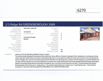
Advertising Leaflet, Barry Plant Greensborough, 2/3 Ridge Road Greensborough, 19/10/2018
... 2/3 Ridge Road Greensborough...ridge road greensborough...Real estate advertisement for 2/3 Ridge Road Greensborough, a 3 bedroom townhouse. ...Previous sales: January 2017 for $800,000. 3 Ridge Road (vacant land) was sold 19/05/2012 for $390,000. ridge road greensborough Real estate advertisement black text and colour photograph 2/3 Ridge Road Greensborough Advertising Leaflet Barry Plant Greensborough ...Real estate advertisement for 2/3 Ridge Road Greensborough, a 3 bedroom townhouse. This house was sold on 14/12/2018 for $850,000. Previous sales: January 2017 for $800,000. 3 Ridge Road (vacant land) was sold 19/05/2012 for $390,000.Real estate advertisement black text and colour photographridge road greensborough -
 Mt Dandenong & District Historical Society Inc.
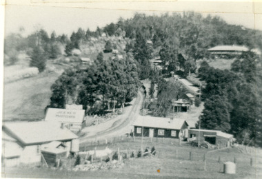
Photograph, Kalorama Gap in 1927, 1927
... ...ridge road...CRB Main Road, Ridge Road, Old Coach Road and barber's Road also visible. ...Showing Jeeves Garage Fiveways Cafe Nicholls Store 'Mountjoy' C.R.B Main Rd Center Ridge Road Right of Center Old Coach Road lower right corner behind shed Barber's Road going left through clump of trees in center ...CRB Main Road, Ridge Road, Old Coach Road and barber's Road also visible. ...View of the Kalorama Gap (FiveWays) in 1927. Buildings shown are Jeeves' Garage, FiveWays Cafe, Nicholl's Store, Mountjoy. CRB Main Road, Ridge Road, Old Coach Road and barber's Road also visible. This photograph has a detailed inscription on the back handwritten by John Lundy-Clarke in 1974. The Kalorama Gap in 1927. Showing Jeeves Garage Fiveways Cafe Nicholls Store 'Mountjoy' C.R.B Main Rd Center Ridge Road Right of Center Old Coach Road lower right corner behind shed Barber's Road going left through clump of trees in center kalorama gap, kalorama, fiveways, fiveways cafe, jeeves, jeeves garage, garage, nicholls store, mountjoy, barbers road, old coach road, ridge road, main road, crb road -
 Mt Dandenong & District Historical Society Inc.
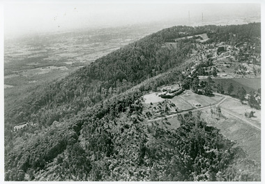
Photograph, View Towards Mt Dandenong 1961, 1961
... ...Ridge Road...Viola Court in foreground, Ridge Road winding up the hill towards the Observatory....Viola Court in foreground, Ridge Road winding up the hill towards the Observatory. ...Looking north towards Mt Dandenong 'City Lights' estate 1961. Viola Court in foreground, Ridge Road winding up the hill towards the Observatory.mount dandenong, ridge road, viola court, city lights estate -
 Mt Dandenong & District Historical Society Inc.
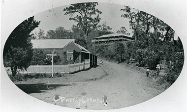
Photograph, 'Pretty Corner' FiveWays c1911
... ...Ridge Road...Two children on Ridge Road and two girls outside the Methodist Church, which is not in view....Two children on Ridge Road and two girls outside the Methodist Church, which is not in view. ...Oval photo, landscape view. Mountjoy on hill. Side view of the Post Office with residence showing the fence and a sign. Two children on Ridge Road and two girls outside the Methodist Church, which is not in view.post office, pretty corner, mountjoy, ridge road, fiveways -
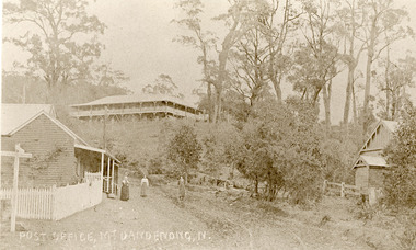 Mt Dandenong & District Historical Society Inc.
Photograph, Post Office Mt Dandenong North c1911, c1911
... ...Ridge Road...Another person standing on Ridge Road on the left. On right, the Methodist Church....Another person standing on Ridge Road on the left. On right, the Methodist Church. ...Landscape view. Mountjoy on hill, post office and residence with fence and sign post. Mrs Eliza Hand and (probably) Miss Florence hand outside. Another person standing on Ridge Road on the left. On right, the Methodist Church.eliza hand, florence hand, methodist church, mountjoy, mt dandenong north, post office, ridge road -
 Mt Dandenong & District Historical Society Inc.
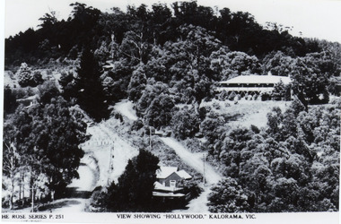
Photograph, View Showing 'Hollywood' Kalorama, Vic
... ...Ridge Road...Mount Dandenong and Ridge Roads are visible at the FiveWays intersection along with the TeaRoom/Post Office. ...Mount Dandenong and Ridge Roads are visible at the FiveWays intersection along with the TeaRoom/Post Office. c1940 Rose Series FiveWays Guest House Mt Dandenong Road Ridge Road Post Office Hollywood Tea Rooms MountJoy The ROSE SERIES P. 251 VIEW SHOWING "HOLLYWOOD". ...Copy of Rose Series postcard #251 showing 'Mountjoy' named as 'Hollywood'. Mount Dandenong and Ridge Roads are visible at the FiveWays intersection along with the TeaRoom/Post Office. c1940Black and white photograph of a bushed setting with a building centre front and another, larger building up hill on RHS. Two unmade roads are visible with fences and telephone/power poles.The ROSE SERIES P. 251 VIEW SHOWING "HOLLYWOOD". KALORAMA, VIC.rose series, fiveways, guest house, mt dandenong road, ridge road, post office, hollywood, tea rooms, mountjoy -
 Whitehorse Historical Society Inc.
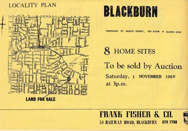
Document, Blackburn 8 Home Sites, 1/11/1969 12:00:00 AM
... Ridge...Blackburn...Masons Road...With frontages to Halley Street, The Ridge and Masons Road....8 home sites to be auctioned by Frank Fisher & Co. on 1 Nov 1969 with frontages to Halley Street, The Ridge and Masons Road....Whitehorse Historical Society Inc. 2-10 Deep Creek Road Mitcham melbourne With frontages to Halley Street, The Ridge and Masons Road. ...Eight home sites to be auctioned by Frank Fisher & Co. on 1 Nov 1969.8 home sites to be auctioned by Frank Fisher & Co. on 1 Nov 1969 with frontages to Halley Street, The Ridge and Masons Road.Eight home sites to be auctioned by Frank Fisher & Co. on 1 Nov 1969. blackburn, frank fisher co., halley street, blackburn, the ridge, blackburn, masons road, blackburn -
 Mt Dandenong & District Historical Society Inc.
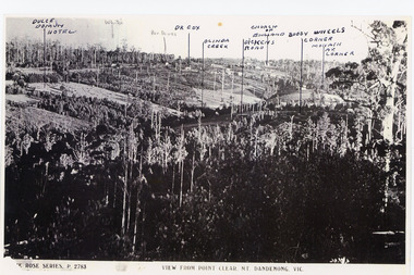
Photograph, View from Point Clear, Mt Dandenong, Vic
... ...Ridge Road...This is taken from Ridge Road. The following indicators have been marked on the photograph L-R Dulce Domun Hotel, White's, Rev. ...This is taken from Ridge Road. The following indicators have been marked on the photograph L-R Dulce Domun Hotel, White's, Rev. ...Rose Series Postcard number 2783Copy of Rose Series postcard #2783 showing view from Point Clear. This is taken from Ridge Road. The following indicators have been marked on the photograph L-R Dulce Domun Hotel, White's, Rev. Davies, Dr. Cox, Olinda Creek, Dickens Road, Church of England, Buggy Wheels Corner, Monash Ave. Corner.mount dandenong, ridge road, rose series, point clear -
 Mt Dandenong & District Historical Society Inc.
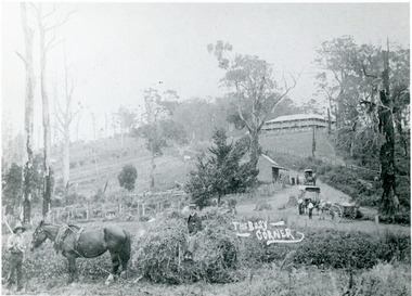
Photograph, 'The Busy Corner' FiveWays c1909, c1909
... ...Ridge Road...Landscape view of Ridge and Barbers Roads showing Mountjoy Guest House on crest, Mt Dandenong North Post Office, three delivery carts and people. ...Farndons Community Hall 42 Falls Road Mt Dandenong yarra-valley-and-the-dandenong-ranges Mountjoy Ridge Road FiveWays Barbers Road Frederick Jeeves Mt Dandenong North Post Office Theo Hand Landscape view of Ridge and Barbers Roads showing Mountjoy Guest House on crest, Mt Dandenong North Post Office, three delivery carts and people. ...Landscape view of Ridge and Barbers Roads showing Mountjoy Guest House on crest, Mt Dandenong North Post Office, three delivery carts and people. Lower LH corner Fred Jeeves (standing), Theo Hand (on wagon) and Blossom (horse).mountjoy, ridge road, fiveways, barbers road, frederick jeeves, mt dandenong north, post office, theo hand -
 Mt Dandenong & District Historical Society Inc.
Photograph, Harry Walker's Home in Village Settlement 1908, c1908
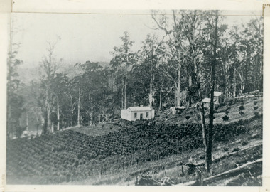
... View of Harry Walker's home taken from waht is now known as Ridge Road, Kalorama. Raspberry crops are in the foreground. ...Looking from what is now Ridge Road through the trees on Vil. Set Lot 18 to Barber’s house now known as “Forest Edge” on Vil Set Lot 25 down close to the Olinda Creek on Barbers Road. ...View of Harry Walker's home taken from waht is now known as Ridge Road, Kalorama. Raspberry crops are in the foreground. ...View of Harry Walker's home taken from waht is now known as Ridge Road, Kalorama. Raspberry crops are in the foreground. This photograph has a detailed inscription on the back handwritten by John Lundy-Clarke in 1974.1908 view of H Walker’s home on Village Settle Lot 2 Section 1. Looking from what is now Ridge Road through the trees on Vil. Set Lot 18 to Barber’s house now known as “Forest Edge” on Vil Set Lot 25 down close to the Olinda Creek on Barbers Road. The Estate Agent’s modern office is on the edge of the patch of raspberries at the lower left as the C.R.B. Mt Dandenong Rd passes just behind Walker’s house crossing the picture behind the raspberries.walker, raspberry crop, forest edge, barber -
 Mt Dandenong & District Historical Society Inc.
Photograph
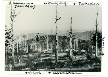
... Iconic photograph taken by Edgar Dower on Ridge Road in 1913 from an area known as Point Clear that shows the buildings of early Mt Dandenong before the CRB road went through in the 1920s....Reverse: 1913 view from O'Halloran's LOT 4, Section 3 on Ridge Road. Showing Lumeah (Namoora) Farndons Road (fence) School, Lowes House?...Reverse: 1913 view from O'Halloran's LOT 4, Section 3 on Ridge Road. Showing Lumeah (Namoora) Farndons Road (fence) School, Lowes House? ...Iconic photograph taken by Edgar Dower on Ridge Road in 1913 from an area known as Point Clear that shows the buildings of early Mt Dandenong before the CRB road went through in the 1920s.Black and white photograph with tall, dead trees in foreground and a view of hills in the distance. Buildings can be seen across the centre of the photograph. There are handwritten annotations around the border with arrows referring to areas in the photograph. Reverse of photograph has handwritten description by John Lundy-Clarke.Front from top left: Namoora (Lumeah), Dower's Shop, First school, Talent's, Langford's house, School. Reverse: 1913 view from O'Halloran's LOT 4, Section 3 on Ridge Road. Showing Lumeah (Namoora) Farndons Road (fence) School, Lowes House?, Falls Road Shop (Dowers) Langford's Falls Road (LOT 9, Section 1) Shed on Colomb's LOT 19, Sect 2 Colomb's House (Fergusons) First school Campbell's Blythes Road Lil Badenhop's P.O. In middle distance - Talent's homestead and sheds.point clear, namoora, lumeah, langford, dower, talent, colomb, ferguson, campbell, farndons road, mt dandenong school -
 Mt Dandenong & District Historical Society Inc.
Photograph, 1908 View of the Kalorama Gap from Main Road With Labelling, 1908
... View of the Kalorama Gap from main Road (now Ridge Road), looking across Walker's raspberry patch with Mountjoy coaching stables on the LHS and Mountjoy Guest House in centre. ...1908 View of the Kalorama Gap from main Road – now Ridge Road above Lot 2 of the Village Settlement. ...View of the Kalorama Gap from main Road (now Ridge Road), looking across Walker's raspberry patch with Mountjoy coaching stables on the LHS and Mountjoy Guest House in centre. ...Photograph with labels attached to front identifying buildings. View of the Kalorama Gap from main Road (now Ridge Road), looking across Walker's raspberry patch with Mountjoy coaching stables on the LHS and Mountjoy Guest House in centre. Price's house and shop on the RHS. This photograph has a detailed inscription on the back handwritten by John Lundy-Clarke in 1974.1908 View of the Kalorama Gap from main Road – now Ridge Road above Lot 2 of the Village Settlement. Looking across Walker’s raspberry patch with “Mountjoy” coaching stables on left. “Mountjoy” in centre. Prices house and shop on right with Hands “Beulah Tearooms” above Prices roof. On hillside beyond Hand’s is the slope now taken up by Kalorama Terrace. Walker’s well, then newly dug is in lower right hand corner below the tree fern head. Mt Kalorama is the hill top right. Track leaving Main Road left is Walker’s entrance drive.kalorama, kalorama gap, walker, beulah tea rooms, price, hand, mountjoy, mt kalorama -
 Federation University Historical Collection
Book, South West Gippsland Tourism Development Strategy, 1989, c1999
... ...grand ridge road...Barker Library (top floor) Mount Helen goldfields tourism tourism strategy south west gippsland gippsland coal creek historical town wilsons promontory penguin parade grand prix grand ridge road wonthaggi phillip island foster korumburra inverloch kilcunda san remo bass bunurong marin park port franklin tarwin lower Black plastic binding on a report tourism and development strategy report. ...Black plastic binding on a report tourism and development strategy report.tourism, tourism strategy, south west gippsland, gippsland, coal creek historical town, wilsons promontory, penguin parade, grand prix, grand ridge road, wonthaggi, phillip island, foster korumburra, inverloch, kilcunda, san remo, bass, bunurong marin park, port franklin, tarwin lower -
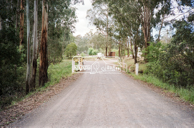
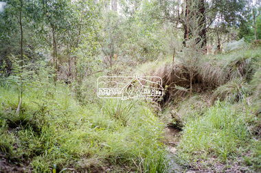
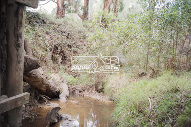
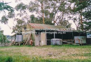
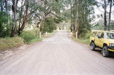 Eltham District Historical Society Inc
Negative - Photograph, Cottlesbridge-Strathewen Road, Strathewen, c.Nov. 1987
... ...school ridge road...A number of the trees were badly burnt or destroyed in the Black Saturday bushfire, 7 Feb. 2009 but some remained standing and identifiable as of 2014 (Google Streetview). bridge chads creek chads creek road cottlesbridge-strathewen road culvert infrastructure roads school ridge road strathewen Kodak GB 200 5096 Roll of 35mm colour negative film, 4 strips Cottlesbridge-Strathewen Road, Strathewen Negative Photograph ...Photos taken during a review of road and bridge/culvert condition by Eltham Shire Council engineers. A number of the trees were badly burnt or destroyed in the Black Saturday bushfire, 7 Feb. 2009 but some remained standing and identifiable as of 2014 (Google Streetview).Roll of 35mm colour negative film, 4 stripsKodak GB 200 5096bridge, chads creek, chads creek road, cottlesbridge-strathewen road, culvert, infrastructure, roads, school ridge road, strathewen -
Mt Dandenong & District Historical Society Inc.
Document, The Busy Corner
... ...Ridge Road...Farndons Community Hall 42 Falls Road Mt Dandenong yarra-valley-and-the-dandenong-ranges Barbers Road FiveWays Frederick Jeeves Post Office Ridge Road Theo Hand Mountjoy Information about photograph #KAL0059 'The Busy Corner' c19009. (2 pages) The Busy Corner Document ...Information about photograph #KAL0059 'The Busy Corner' c19009. (2 pages)barbers road, fiveways, frederick jeeves, post office, ridge road, theo hand, mountjoy -
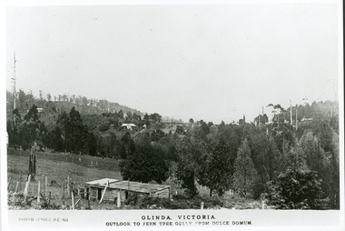 Mt Dandenong & District Historical Society Inc.
Photograph, Olinda, Victoria. Outlook to Ferntree Gully from Dulce Domun
... Copy of Photo Series postcard #965 with view looking west to Mt Dandenong Road and Ridge Road. Looking across to where the Log Cabin (Kellys) would now be....Farndons Community Hall 42 Falls Road Mt Dandenong yarra-valley-and-the-dandenong-ranges Rose Series Postcard number 965 Mount Dandenong Dulce Domum Photo Series Copy of Photo Series postcard #965 with view looking west to Mt Dandenong Road and Ridge Road. Looking across to where the Log Cabin (Kellys) would now be. ...Rose Series Postcard number 965Copy of Photo Series postcard #965 with view looking west to Mt Dandenong Road and Ridge Road. Looking across to where the Log Cabin (Kellys) would now be.mount dandenong, dulce domum, photo series -
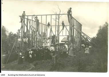 Mt Dandenong & District Historical Society Inc.
Photograph, Building the Methodist Church at Kalorama, 1909
... Local residents working to erect the frame of the Methodist Church on the Main Road (Ridge Road) at Kalorama. Eight workmen are on the frame with fifteen well dressed residents standing in front. 1910. ...(Lundy-Clarke manuscript) Church Kalorama Methodist Church Methodist Church Printed on front of photo: 1909 Building the Methodist Church at Kalorama Local residents working to erect the frame of the Methodist Church on the Main Road (Ridge Road) at Kalorama. Eight workmen are on the frame with fifteen well dressed residents standing in front. 1910. ...The Methodist Church was built in 1910 by volunteer labour. Mainly through the efforts of the daughters of Eliza Hand and their families - the Jeeves, Walkers and Badenhops. (Lundy-Clarke manuscript)Local residents working to erect the frame of the Methodist Church on the Main Road (Ridge Road) at Kalorama. Eight workmen are on the frame with fifteen well dressed residents standing in front. 1910. Image received as a digital jpeg.Printed on front of photo: 1909 Building the Methodist Church at Kalorama church, kalorama methodist church, methodist church -
 Mt Dandenong & District Historical Society Inc.
Photograph, 1908 View of Kalorama Gap From the Main Road, 1908
... View of the Kalorama Gap from main Road (now Ridge Road), looking across Walker's raspberry patch with Mountjoy coaching stables on the LHS and Mountjoy Guest House in centre. ...Farndons Community Hall 42 Falls Road Mt Dandenong yarra-valley-and-the-dandenong-ranges mountjoy walker raspberry coach stables View of the Kalorama Gap from main Road (now Ridge Road), looking across Walker's raspberry patch with Mountjoy coaching stables on the LHS and Mountjoy Guest House in centre. ...View of the Kalorama Gap from main Road (now Ridge Road), looking across Walker's raspberry patch with Mountjoy coaching stables on the LHS and Mountjoy Guest House in centre. Price's house and shop on the RHS.mountjoy, walker, raspberry, coach, stables -
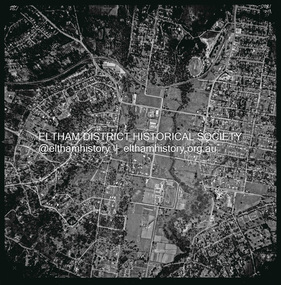 Eltham District Historical Society Inc
Photograph - Aerial Photograph, Landata, Eltham, Vic, Apr. 1963
... Ridge...Main Road...Centred on present day Eltham Ridge, Bolton Street, Eltham bounded by Elsa Court to north, Main Road to south, Bible Street to east and Reichelt Avenue and Rattray Road to west. ...Historic Aerial Imagery Source: Landata.vic.gov.au Aerial Photo Details: Project No :486 Project : MELBOURNE (1963) PROJECT Run : 6 Frame : 124 Date : 04/1963 Film Type : B/W Camera : RC8 Flying Height : 5100 Scale : 9600 Film Number : 1805 GDA2020 : 37°43'12"S, 145°08'16"E MGA2020 : 335876, 5823604 (55) Melways : 21 G6 (ed. 42) Aerial Photo Neil Webster Collection 1963-04 Bible Street Bolton Street Eltham Eltham Ridge Main Road Montmorency Rattray Road Reichelt Avenue Digital jpg and electronic PDF file Eltham, Vic. ...Centred on present day Eltham Ridge, Bolton Street, Eltham bounded by Elsa Court to north, Main Road to south, Bible Street to east and Reichelt Avenue and Rattray Road to west. Historic Aerial Imagery Source: Landata.vic.gov.au Aerial Photo Details: Project No :486 Project : MELBOURNE (1963) PROJECT Run : 6 Frame : 124 Date : 04/1963 Film Type : B/W Camera : RC8 Flying Height : 5100 Scale : 9600 Film Number : 1805 GDA2020 : 37°43'12"S, 145°08'16"E MGA2020 : 335876, 5823604 (55) Melways : 21 G6 (ed. 42)aerial photo, neil webster collection, 1963-04, bible street, bolton street, eltham, eltham ridge, main road, montmorency, rattray road, reichelt avenue -
 Eltham District Historical Society Inc
Photograph, Murray's House Eltham North, June 1993, 1993
... ridge...wattletree road...Eltham District Historical Society Inc 728 Main Rd Eltham melbourne houses outbuildings eltham north jim murray murrays place casuarina ridge wattletree road Twenty-three colour photographs of Jim Murray's house, Eltham North showing house and barn and dug out dairy Murray's House Eltham North, June 1993 Photograph Photograph ...Twenty-three colour photographs of Jim Murray's house, Eltham North showing house and barn and dug out dairyhouses, outbuildings, eltham north, jim murray, murrays place, casuarina ridge, wattletree road -
Glenelg Shire Council Cultural Collection
Postcard - Postcard - Portland Victoria Landmarks, NUCOLORVUE PRODUCTIONS PTY LTD, n.d
... Edward Henty cottage, Ridge Road Olinda - top left photo, store and cottage, top right. ...Edward Henty cottage, Ridge Road Olinda - top left photo, store and cottage, top right. ...Coloured postcard, consists of 4 small photographs separated by white border, wavy edges. Edward Henty cottage, Ridge Road Olinda - top left photo, store and cottage, top right. Cottage kitchen bottom left, cottage at bottom rightBack: Information about Edward Henty. 'Love from Nita' in blue biro -
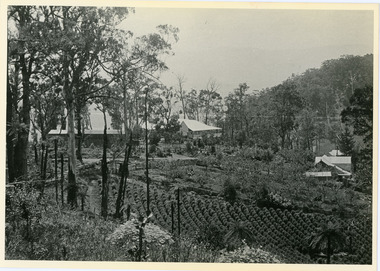
 Mt Dandenong & District Historical Society Inc.
Photograph
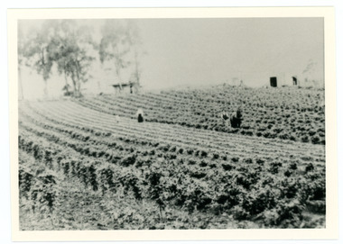
... Property was named "Bonnie View" and photo was taken from near where the Channel O tower stands looking south east towards corner of Ridge Road and Selwyn Lane taken 1920....Property was named "Bonnie View" and photo was taken from near where the Channel O tower stands looking south east towards corner of Ridge Road and Selwyn Lane taken 1920. Black and white photograph showing rows of berry crops. ...William Dower came with his family to the Mt Dandenong in 1898, taking up a 10 acre allotment. William and hs wife Elizabeth had seven boys (Will, Harry, Bert, Walter, Joe, Edgar, Robert) and four girls (Emmy, May, Ada, Ruby). The property secured by William Dower was known as ‘Cambridge Gardens’ and had a two room slab hut. William and his sons added another five rooms using trees from the property. The family established extensive crops and worked hard for their success. The acreage extended to 30 when the family bought up neighbouring properties.Black and white photograph showing rows of berry crops. Reverse of photograph has handwritten description by John Lundy-Clarke.LOT 10 section 2 of the Village Settlement owned as registered by Dobson, then Bert Dower, then Edgar Dower. Property was named "Bonnie View" and photo was taken from near where the Channel O tower stands looking south east towards corner of Ridge Road and Selwyn Lane taken 1920.bert dower, edgar dower, bonnie view, channel o, dobson, selwyn lane -
 Southern Sherbrooke Historical Society Inc.
Photograph - Photo - Bagged-up spuds awaiting collection on Hermon's farm
... Road, Menzies Creek. Land was leased from Forest Dept. Trees are in the middle ground and behind them, the ridge of Ridge Road can be seen. ...Road, Menzies Creek. Land was leased from Forest Dept. Trees are in the middle ground and behind them, the ridge of Ridge Road can be seen. ...B&W photo showing rows of filled potato sacks in a field at Hermon's farm on Black Hill Road, Menzies Creek. Land was leased from Forest Dept. Trees are in the middle ground and behind them, the ridge of Ridge Road can be seen. See also M0055 taken from the same position. -
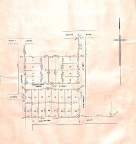 Ringwood and District Historical Society
Card - Double-sided Display, Land Subdivision Map Samples
... Side 2 - Extract from Land Auction advertisement for sale of 23 allotments in Ridge Road, Oakley Street and Mount Dandenong Tourist Road, Mount Dandenong, Victoria - circa 1950s....Side 2 - Extract from Land Auction advertisement for sale of 23 allotments in Ridge Road, Oakley Street and Mount Dandenong Tourist Road, Mount Dandenong, Victoria - circa 1950s. ...Side 1 - Layout of 20 residential allotments in Shasta Avenue, Merrilong Street, Northwood Street and Alexandra Road, Ringwood East, Victoria (Undated). Side 2 - Extract from Land Auction advertisement for sale of 23 allotments in Ridge Road, Oakley Street and Mount Dandenong Tourist Road, Mount Dandenong, Victoria - circa 1950s. -
 Mt Dandenong & District Historical Society Inc.
Photograph
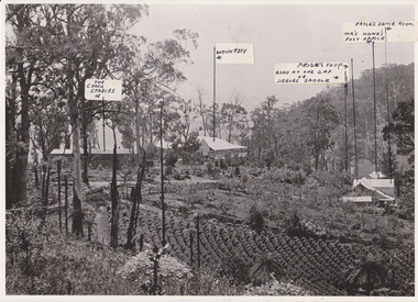
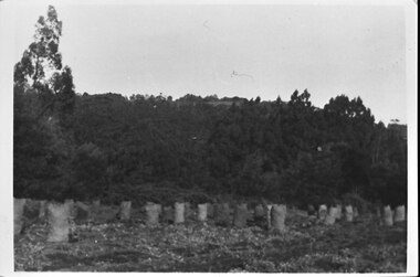
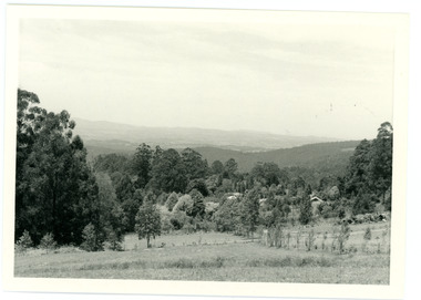
... In 1913 Edgar Dower took a photograph from this spot on Ridge Road that became known as Point Clear showing the Mt Dandenong township behind a stand of tall, dead trees. ...Farndons Community Hall 42 Falls Road Mt Dandenong yarra-valley-and-the-dandenong-ranges In 1913 Edgar Dower took a photograph from this spot on Ridge Road that became known as Point Clear showing the Mt Dandenong township behind a stand of tall, dead trees. ...In 1913 Edgar Dower took a photograph from this spot on Ridge Road that became known as Point Clear showing the Mt Dandenong township behind a stand of tall, dead trees. John Lundy-Clarke took this photograph from a similar spot at the Mt Dandenong Arboretum in 1975.Black and white photograph showing a cleared area in the foreground with young tress in the centre and hills in the distance. Several rooftops can be seen mid photo on the right. Reverse of photograph has handwritten description by John Lundy-Clarke.1975 View from the Arboretum over Mt D'nong township at the spot where Edgar Dower took the 1913 photo. The Falls gully is in the middle distance. Peter Damman's fence running downhill right foreground.edgar dower, point clear, mt dandenong, john lundy-clarke, peter damman, arboretum -
 Southern Sherbrooke Historical Society Inc.
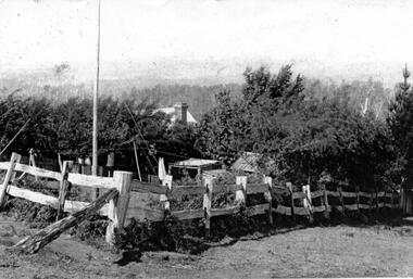
Photograph - Tantallon, Douglas farm at Menzies Creek/Emerald
... Black and White photograph of 'Tantallon', the Menzies Creek/Emerald Farm owned by Norah and Percy Douglas, situated on the north side of Ridge Road. The photo shows a corner of a post and rail fence enclosing a small farm paddock. ...Southern Sherbrooke Historical Society Inc. 127 Colby Drive Belgrave Heights 3160 yarra-valley-and-the-dandenong-ranges Black and White photograph of 'Tantallon', the Menzies Creek/Emerald Farm owned by Norah and Percy Douglas, situated on the north side of Ridge Road. The photo shows a corner of a post and rail fence enclosing a small farm paddock. ...Black and White photograph of 'Tantallon', the Menzies Creek/Emerald Farm owned by Norah and Percy Douglas, situated on the north side of Ridge Road. The photo shows a corner of a post and rail fence enclosing a small farm paddock. Behind a row of trees, a brick chimney and part of a roof can be seen, presumably the main farmhouse. Timbered hills can be seen in the background. The photo appears to be taken looking north. See also VSSH0046 for more details.