Showing 5784 items matching river%20murray
-
 Kew Historical Society Inc
Photograph, Marnie McLeod, Floods on the River Yarra at Kew, 1916
The donation was accompanied by the following letter from the donor: "Hi. I found these in with family photos. Taken by family as Mamie McLeod was living in Fellows Street, Kew, so would be near there. Retain (or discard) as you see fit." [Donor's name and address withheld from public view]. To gain an insight into the flood levels at Kew, it is worth reading newspaper accounts of the event. The Age published an article - Valuable Gardens Destroyed at Kew - on 25 September 1916: "VALUABLE GARDENS DESTROYED AT KEW. From the heights of Studley Park, Kew, a splendid view of the flood waters can be obtained, and yesterday afternoon, despite continuous rain, crowds of citizens assembled there to witness the spectacle. There is a vast stretch of water some 300 or 400 yards broad, above the foot bridge connecting Gipps-street, Collingwood, and Studley Park. The river is only about 3 feet from the top of the embankment connecting with the ramp of the bridge on the Studiey Park side. When the upper llood waters come down it is almost a certainty that tne embankment will be submerged and the bridge rendered impassible. Below the bridge the waters again stretch out, and have submerged all the low-lying land on the Collingwood side and invaded the back premises ot the Kodak Co., Phoenix Biscuit Factory, a tannery adjoining thereto, the Shamrock Brewery, and Chinese gardens in the vicinity. At Walmer-street-bridge, at the end of Studley Park, the low-lying land on the Kew side is covered with water to the depth of many feet. Tlie land in question is owned in a great part by Mr Frank Lavers who haa gone in for intense culture on a pretty liberal scale on both the slopes of the hill and on the river flat. On the latter he is cultivating many acres of asparagus, and has at a considerable cost spent three years in preparing the ground and installing an irrigation system, reticulated from the Yan Yean water supply. This year the asparagus was put down, and the plants were in a promising condition. Tlie flood waters are now flowing fast over the land. The crop is ruined, and three years' work and expenditure destroyed. Mr. Laver's private residence fortunately is high above flood level, but two houses he owns off Young-street have been flooded out. Having been warned in time, the tenants removed their furniture hefore the water came down to Mr. Laver's residence, where they themselves have been given accommodation in the meantime. All the river flats in East Kew are under water. One or two low-lying houses have been flooded. Chipperfield's boat shed at Willsmere is nearly covered, and some Chinese gardens in the vicinity are several feet under water."This, and the other three photographs donated of floods in Kew are believed to be the earliest in the collection. Together with our original MMBW River Yarra map showing flood levels, these items, when compared allow researchers to gain a visual perspective of the extent of the flood in 1916. Panoramic view, believed to be looking north towards Fairfield from the Zig-Zag Bridge on the River Yarra. The inscription on the reverese identifies it as taken before 1920.Inscription on reverse in ink "(pre 1920) Flood from Zig-zag bridge Yarra River, Kew Vic."river yarra, kew, floods 1916, zig-zag bridge -
 Orbost & District Historical Society
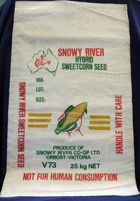
seed bag
This unused bag would have been used by Snowy River Co-Op Ltd to pack sweet corn in the late 1960's -1980's Snowy River Seeds started life as a farmers' co-operative (Snowy River Co-op) in 1967 specialising in horticulture. Snowy River Co-op were the original creators of Snowy Seeds.This item is significant because it was specially made for the seed bean industry which is a major industry in the Orbost district.A white synthetic woven fibre bag used to pack sweet corn prior to sale. It has red, green, yellow print.On front of bag - Logo of Man From Snowy River in outline map of Australia with a hand holding corn cob in the centre, Produce of Snowy River Co-Op Ltd Orbost- Victoria V73 25kg NETsweet-corn seed-bags snowy-river-co-op -
 Federation University Historical Collection
Photograph - Colour, Leigh River near Garibaldi Bridge
The Leigh River is a major tributary and catchment of the Barwon River. Fed by the Yarrowee River that rises near Ballarat, the Yarrowee reaches its confluence to form the Leigh in the vicinity of Cambrian Hill and Golden Plains Shire. The Leigh River rises below Mount Mercer and flows generally south, joined by three minor tributaries before reaching its confluence with the Barwon River, southeast of the central business district of Inverleigh. The river descends 265 metres (869 ft) over its 61-kilometre (38 mi) course. (https://en.wikipedia.org/wiki/Leigh_River_(Victoria)Relates to historical information about flooding of the Leigh River in 1933. Relevant to the history of Garibaldi and Durham Lead.A number of colour photographs showing the Leigh River between Garibaldi and Durham Lead, Victoria, .1 - .3) photographs of the Leigh River in flood .4 - .18) general photos of the Leigh River and surrounding countryside .19) broad angle photograph of the Leigh River and surrounding countryside leigh river, garibaldi, garibaldi bridge, durham lead, vincent family -
 Kew Historical Society Inc
Photograph, Outer Circle Railway Bridge over River Yarra, c.1900
This photograph forms part of the Eric Sibly collection of images and information relating to the Outer Circle Railway which he donated to the Kew Historical Society in 1974. Heritage Victoria Citation (Abridged) "The Chandler Highway Bridge, a 137 metre wrought iron lattice-truss girder bridge with four spans supported on red brick piers with moulded bluestone cappings. The bridge has a cantilevered walkway along the west side. ...The Chandler Highway Bridge crosses the Yarra River and connects Alphington and Kew. It was completed in November 1890 as part of the Outer Circle Railway Line.Black & white photograph of the railway viaduct over Yarra River looking south towards Kew.Reverse: "Pre 1930. Outer Circle Railway Bridge over River Yarra (now Chandler Highway) - note bridge over line on Kew side for Asylum Farm". KH - 56. Kew Historical Society.chandler highway, railway bridges - kew (vic), sir john monash, outer circle railway, river yarra - kew (vic) -
 Tatura Irrigation & Wartime Camps Museum
Photograph, Eildon Reservoir - Goulburn River, 1918
Taken by photographer for State Rivers and Water Supply Commission.Medium sized black and white photograph. Eildon Reservoir on the Goulburn River / Overall picture of dam (Right of wall) filled with water and some leisure craft moored near shore and huts / Dam wall and spillway / tree covered hills beyond"Eildon Reservoir - Goulburn River / Capacity - 306,000 acre feet / Rock filled dam with mass concrete spillway / Total length of dam - 3000 feet / Maximum depth of water - 123 feet - etc"victorian state rivers and supply commission, eildon dam -
 Rutherglen Historical Society
Book, Kath Bentley et al, River of Islands: Charts of the River Murray Yarrawonga Weir to Hume Dam, November 1983
Book contains information and sketch maps to aid in the navigation of the Murray River, with advice on hazards to look for as these will change over time.74 page A4 book with a drawing of a boat on the Murray River on the coverAutographed on the title page by the authors: "9-1-84 Leon Bentley | Kath Bentley"murray river, boating, river navigation, boating safety -
 Ballarat Heritage Services
Photograph - Photograph - Colour, Clare Gervasoni, Brembo River, Near San Giovanni Bianco, Lombardy, Italy, 2001
The Brembo River is a 74-kilometer river which runs entirely within the Province of Bergamo in the Lombardy Region of Italy.Colour photograph of the Brembo River.brembo river, san giovanni bianco, italy -
 Marysville & District Historical Society
Postcard (item) - Colour postcard, Souvenirs Australia Pty. Ltd, A Ford on the Acheron River, 1881, Post 1995
A postcard from a painting of a ford on the Acheron River that was painted in 1881 by H.J. Johnstone.A postcard from a painting of a ford on the Acheron River that was painted in 1881 by H.J. Johnstone. The original painting is oil on canvas and was donated to the Broken Hill City Art Gallery in 1948 by Mr. O. Von Rieben. This postcard was produced by Souvenirs Australia Pty. Ltd. in Glynde, South Australia as a souvenir of Marysville.H.J. JOHNSTONE/ A FORD ON THE ACHERON RIVER, 1881/ OIL ON CANVAS, 171cm x 245cm/ BROKEN HILL CITY ART GALLERY/ DONATED BY MR. O. VON RIEBEN, 1948 Made in/ Australia by/ Souvenirs Aust./ Pty. Ltd./ Adelaide/ BHG 2 ADDRESS Published by/ Souvenirs Australia Pty. Ltd./ Glynde/ Copyright A PITT CARDacheron river, oil painting, h.j. johnstone, broken hill city art gallery, mr. o. von rieben, postcard, souvenirs australia, souvenir -
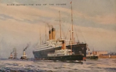 Kew Historical Society Inc
Postcard, Valentine's Series, River Mersey - The End of the Voyage, c.1928
Collection of thirty-nine postcards donated by Jillian Rigby which had been owned by her grandparents, George and Edith Weir, who from c.1917 lived at 84 Princess Street, Kew. The mostly 'mint' postcards were purchased in Victoria and while travelling overseas. The sole dated postcard is dated from 1929. The postcards are numbered sequentially from 2017.0058.01-39. The remainder of the collection donated by Jill Rigby which was once owned by the Weirs of Broken Hill and Kew consist of costumes, costume accessories, photographs, and documents.The postcards in the Weir collection, especially those purchased on a trip or trips to the mother country, i.e. United Kingdom, represent a representative sample of sites that were considered significant to those Australians undertaking a reverse grand tour by member of the erstwhile colonies. Those postcards which are early views of Melbourne must have been produced commercially for some decades from the early part of the 20th century.River Mersey - The End of the Voyage. One of a set of three [originally six] 'High Class Postcards of Memories of the Mersey, Beautifully Reproduced in Nature Colours', in their original brown envelope. The postcard was probably purchased by George and Edith Weir on a trip to England and Scotland, circa 1928."River Mersey - The End of the Voyage"postcards, george and edith weir, river mersey, postcards -- uk, weir collection -
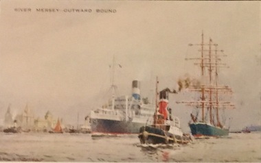 Kew Historical Society Inc
Postcard, Valentine's Series, River Mersey - Outward Bound, c.1928
Collection of thirty-nine postcards donated by Jillian Rigby which had been owned by her grandparents, George and Edith Weir, who from c.1917 lived at 84 Princess Street, Kew. The mostly 'mint' postcards were purchased in Victoria and while travelling overseas. The sole dated postcard is dated from 1929. The postcards are numbered sequentially from 2017.0058.01-39. The remainder of the collection donated by Jill Rigby which was once owned by the Weirs of Broken Hill and Kew consist of costumes, costume accessories, photographs, and documents.The postcards in the Weir collection, especially those purchased on a trip or trips to the mother country, i.e. United Kingdom, represent a representative sample of sites that were considered significant to those Australians undertaking a reverse grand tour by member of the erstwhile colonies. Those postcards which are early views of Melbourne must have been produced commercially for some decades from the early part of the 20th century.River Mersey - Outward Bound. One of a set of three [originally six] 'High Class Postcards of Memories of the Mersey, Beautifully Reproduced in Nature Colours', in their original brown envelope. The postcard was probably purchased by George and Edith Weir on a trip to England and Scotland, circa 1928."River Mersey - Outward Bound"postcards, george and edith weir, river mersey, postcards -- uk, weir collection -
 Orbost & District Historical Society
book, Snowy River Mail as "Mail" Print, Princes Freeway Orbost Section, 2117.1 : 1976 2117.2 : 4.9.2013
The Snowy River Bridge, Princes Freeway, Orbost, Victoria was opened by the Hon. J A Rafferty, Minister for Transport, 25 November 1976. ‘The bridge was built at a cost of A$2.4 million and is the first of four bridges to be built as part of the 8.4 kilometre freeway bypass of Orbost. Construction of the bridges commenced in January 1975, with an expectation to open the bridge across the Snowy River as soon as possible. Less than two years later, on 25 November 1976, the bridge across the Snowy River was opened to traffic, allowing the old bridge to be demolished. The remainder of the Orbost Bypass, both the floodplain crossings and the eastern section around the township itself, was declared ‘Princes Freeway’. The newspaper article was written by David Jellie as part of the centenary celebrations of Vic Roads/Country Roads on 4.9.2013. David Jellie was the project engineer for the Snowy River Crossing Project.This book and article contain historical information and details about the construction of the bridges on the Orbost section of the Princes Freeway.2117.1 isaA thin paperbook book which contains a map, history and construction details of the Princes Freeway at Orbost. It has a program for the opening ceremony of the snowy River Bridge in 1976. 2117.2 is an article from the snowy River Mail on the history of the highway. It is dated 4.9.2013.In pencil - 20csnowy-river-bridge jellie-david princes-freeway-orbost -
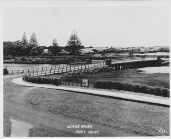 Port Fairy Historical Society Museum and Archives
Postcard, Moyne River Port Fairy
This bridge was built in 1902, replacing a previous structure that crossed the Moyne River from 1857 and linked Belfast with Belfast East, as the two areas of Port Fairy were then known. Prior to that, passage over the river was via a ford (an underwater stone track that allowed wagons to cross when the river was low) located just north of where the current car bridge stands. The present bridge survived the great flood of 1946, but has been the subject of innumerable patch-up jobs over its 114 years. In 2012, the bridge underwent a detailed structural assessment and was given the OK for the next eight to 10 years, notwithstanding the need for regular maintenance works. At the time, it was estimated a new bridge would cost between $2-3 million. It was extensively refurbished in 2016Sole means for traffic to cross to the east side of Port FairyBlack and white photographMoyne River Port Fairyriver, moyne, bridge, road -
Whittlesea Historical Society Inc.
Photograph, Bridge over Plenty River at South Morang
Bridge over Plenty River at South Morang.B&W Copy of photograph printBridge over Plenty River at South Morangbridge, south morang, plenty river -
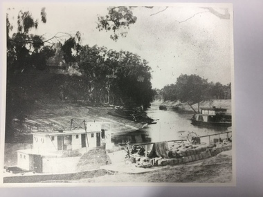 Port of Echuca
Photograph, Paddle steamers on Darling River, 1982 (approx)
Original photograph held by J.Norris, Butcher Street Echuca. Thought to be approximately 1910.Photograph shows very low river level. Barge is loaded with wool bales moored at closest river bank. Barge could be in the process of loading. Barge is between bank and the paddle steamer. Deck hand can be seen in fore ground holding a long pole. Steering wheel is visible on the barge.Black & white photograph which shows 2 paddle steamers & a barge rounding a bend in the Darling River. Barge is loaded with wool bales. Water level is not high: bank slopes clearly visible.On back of photograph is written "Jane(?) in Darling River. Norris collection."darling river; paddle steamers; river trade; wool production on darling river; river transport; barges; low river; -
![View on the Upper Buckland River / [by] Nicholas Caire, circa 1876](https://victoriancollections.net.au/media/collectors/550653872162f11fb04854aa/items/57830fc0d0cdd1176c450fda/item-media/57831013d0cdd1176c454bda/item-fit-380x285.jpg) Kew Historical Society Inc
Kew Historical Society IncPhotograph, Anglo-Australasian Photographic Company, View on the Upper Buckland River, c. 1876
Nicholas Caire was born on Guernsey in the Channel Islands in 1837. He arrived in Adelaide with his parents in about 1860. In 1867, following photographic journeys in Gippsland, he opened a studio in Adelaide. From 1870 to 1876 he lived and worked in Talbot in Central Victoria. In 1876 he purchased T. F. Chuck's studios in the Royal Arcade Melbourne. In 1885, following the introduction of dry plate photography, he began a series of landscape series, which were commercially successful. As a photographer, he travelled extensively through Victoria, photographing places few of his contemporaries had previously seen. He died in 1918. Reference: Jack Cato, 'Caire, Nicholas John (1837–1918)', Australian Dictionary of Biography.An original, rare photograph from the series 'Views of Victoria: General Series' by the photographer, Nicholas Caire (1837-1918). The series of 60 photographs that comprise the series was issued c. 1876 and reinforced a neo-Romantic view of the Australian landscape to which a growing nationalist movement would respond. Nicholas Caire was active as a photographer in Australia from 1858 until his death in 1918. His vision of the Australian bush and pioneer life had a counterpart in the works of Henry Lawson and other nationalist poets, authors and painters.‘View on the upper Buckland River’ : Views of Victoria (General Series) No.46 : Albumen silver photograph | Photo on card with Title and Description on reverse | Mounted 24 x 30 cm; Photo 12 x 17 cm.On Reverse: ‘The Buckland River is situated near the western extremity of the Australian Alps, and forms one of the sources of the Ovens River. Its watercourse is very shallow, except in flood time. Our illustration is taken on the upper portion of the River, near Reeve’s dam.’nicholas caire (1837-1918), buckland river (vic), landscape photography - victoria -
Greensborough Historical Society
Maps, Plenty River, 1837o
These maps show the land use along the Plenty River. Both Aboriginal and white settlements are shown.Set of maps showing the Plenty River. -
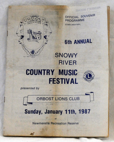 Orbost & District Historical Society
souvenir program, 1987
The annual Snowy River Country Music Festival was organised by the Lions Club of Orbost and held at the Newmerella Recreation Reserve. The 6th event was held on Sunday, Jan 11 1987.This program is significant in that it is a souvenir of a local event which no longer takes place.An official souvenir program for the 6th annual Snowy River Country Music Festival, 1987. B/W print.snowy-river-country-music-festival program souvenir -
Tatura Irrigation & Wartime Camps Museum
Photograph, Goulburn River, 1880
Taken by photographer for State Rivers and Water Supply CommissionMedium sized black and white photograph. Red gum and man on river bank in foreground - fast flowing river - opposite bank shown upper corner.victoria state rivers and water supply commission, goulburn river -
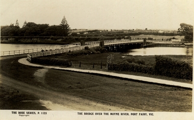 Port Fairy Historical Society Museum and Archives
Postcard, The Rose Series / The Rose Stereographs, The Bridge over Moyne River, Port Fairy Vic
Black and white Photograph of the Moyne river road bridge with the botanical gardens in the left background and some huts built possibly on Hughes AvenueThe Rose Series P.1123 copyright.- The Bridge over the Moyne River Port Fairy Vic.moyne bridge, hughes avenue, gipps street, river, dunes, botanical gardens -
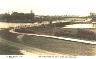 Port Fairy Historical Society Museum and Archives
Postcard, The Rose Series / The Rose Stereographs, The Bridge over Moyne River, Port Fairy Vic
Black and white Photograph of the bridge over the Moyne river with the Botanical Gardens on the left in the background and also some huts on Hughes Avenue in the backgroundThe Rose Series P. 1123 copyright- The Bridge over the Moyne River Port Fairy Vic.moyne bridge circa 1930, moyne river, bridge, river, botanical gardens -
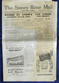 Orbost & District Historical Society
newspaper, 15.2.1950
The Snowy River Mail is a weekly newspaper published in Orbost in the Shire of East Gippsland, Victoria, Australia. Previously published as The Snowy River mail and Tambo and Croajingolong gazette from 1890 to 1911. The Gippsland Courier merged with the Snowy River Mail when proprietor Lachlan Ross moved to Orbost in 1910. In 1999 the paper was acquired by the Yeates family when the Hollins family retired from the newspapers business. The paper is still being produced by the fourth generation of the Yeates family as part of East Gippsland Newspapers. The flood in 1950 was a significant Orbost event. This newspaper is a contemporary record of a significant local events.A Snowy River Mail newspaper dated 15,.2.1950. It contains news articles and advertisements in black/white print. There is an artcle about the Orbost floods.newspaper snowy-river-mail flood-1950-orbost -
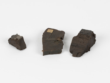 The Beechworth Burke Museum
Geological specimen - Coorongite
Coorongite is a dark, rubber-like, highly resilient structureless algal deposit. In the Coorong district of South Australia it occurs in moderate quantities associated with the coastal swamps and sand dunes which extend for a considerable distance east of the mouth of the Murray. This particular specimen was recovered from the south of the Coorong River, South Australia. A type of sediment rich in organic matter, Coorongite is the unlithified end-member of the sapropelic coal series. The members of the sapropelic coal series can be ranked in order as sapropel (the unlithified form), sapropelic-lignite, and sapropelic-coal (the lithified forms) based on increasing carbon content and decreasing volatile content. Sapropel (Coorongite) is an unlithified dark, pulpy, fine organic mud containing concentrations of algae and miospores that are more or less identifiable. Coorongite is typically found as an algae like substance, that can be found in irregular size pieces. Coorongite was believed to be dried up oil due to its rubber-like texture. The Coorongite is also soft to the point where it can be cut into with a knife or it can be broken and torn by hand. Otherwise known as 'Kurangk', the Coorong River is home to the Ngarrindjeri people, which acts as both a place for gathering food and a spiritual place. In 1852 the first sight of Coorongite was found along the Coorong River. The finders mistook the Coorongite for dried up oil, which lead to the belief that there were oil reserves under the Coorong River. Between the 1860s and the 1930s the Coorong River became a place where mining oil and Coorongite became precedent. Nowadays, the local council and the South Australian Government are working together with the Ngarrindjeri people to sustain and preserve the Coorong River and the culture that is with it. Soon after gold was discovered in 1851, Victoria’s Governor La Trobe wrote to the Colonial Office in London, urging ‘the propriety of selecting and appointing as Mineral Surveyor for this Colony a gentleman possessed of the requisite qualifications and acquaintance with geological science and phenomena’. Alfred Selwyn was appointed geological surveyor in Australia in 1852 which began the Geological Survey of Victoria. Selwyn went on to collect geological samples and catalogue thousands of specimens around Australia. In 1853-69 the Geological Survey issued under Selwyn's direction sixty-one geological maps and numerous reports; they were of such high standard that a writer in the Quarterly Journal of the Geological Society of London bracketed the survey with that of the United States of America as the best in the world. During his years spent in Australia, Selwyn collected numerous significant geological specimens, examples of which are held in collections such as the Burke Museum.Coorongite is considered to be a mineral with a unique texture, where it can be both hard and soft. Coorongite can also be considered to be a rare mineral, as it is only located along the Coorong River and due to the mining of it, has left very few sources. It was believed at one point that Coorongite could be used to replace oil. This specimen is part of a larger collection of geological and mineral specimens collected from around Australia (and some parts of the world) and donated to the Burke Museum between 1868-1880. A large percentage of these specimens were collected in Victoria as part of the Geological Survey of Victoria that begun in 1852 (in response to the Gold Rush) to study and map the geology of Victoria. Collecting geological specimens was an important part of mapping and understanding the scientific makeup of the earth. Many of these specimens were sent to research and collecting organisations across Australia, including the Burke Museum, to educate and encourage further study.Three solid varyingly hand-sized pieces of wooden appearing organic matter derived from the river in the Coorong District in South Australia. A rubber-like, highly resilient structureless algal deposit.Specimen 245 page 69 / in Descriptive Register / "Elcestic Bitumen, / Coorangite" South of / Coorung River, South Australia . / C. WIllman / 15/4/21burke museum, beechwoth, indigo shire, beechworth museum, geological, geological specimen, mineraology, coorong, coorong river, kurangk, ngarrindjeri, south australia, coorongite, coorongite specimen -
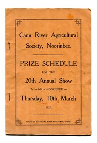 Orbost & District Historical Society
program, Snowy River Mail, 1927
Cann River is a town in the East Gippsland region of Victoria in Australia. The town is located on the Cann River at the junction of the Princess Highway and the Monaro Highway, in the Shire of East Gippsland. Before 1929 the original Cann River settlement was where Noorinbee now stands.Agricultural shows are an important part of cultural life in small country towns and these shows form an integral part of local history. This item reflects the significance of a volunteer group which no longer exists.A stapled paper program, orange with black print,"Cann River Agricultural Society, Noorinbee Prize Schedule for the 20th Annual Show to be held at Noorinbee on Thursday 10th March 1927" inside a rectangular black frame. -
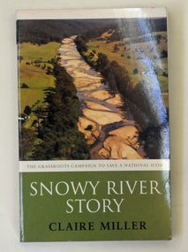 Orbost & District Historical Society
book, Snowy River Story, April 2005
This book recounts the story of the campaign by Dalgety and Orbost to restore water to the Snowy River. Claire Miller is a senior journalist for The Age newspaper with a special interest in the environment. She has covered this campaign since 1999.This book recounts the story of the campaign by Dalgety and Orbost to restore water to the Snowy River. It is significant to this collection as many of the current residents of Orbost were involved in the campaign.A 270pp paperback book titled Snowy River Story written by Claire Miller. On the front cover is a coloured photograph of the Snowy River at Bete Bolong. It documents the story of the campaign to save the Snowy River.snowy-river snowy-mountains-hydro-electric-scheme environmental -
![Waterfall Scene Near the Buchan River / [by] Nicholas Caire, circa 1876](https://victoriancollections.net.au/media/collectors/550653872162f11fb04854aa/items/57825da5d0cdd1176ce3ed3d/item-media/57825e03d0cdd1176ce418cf/item-fit-380x285.jpg) Kew Historical Society Inc
Kew Historical Society IncPhotograph, Anglo-Australasian Photographic Company, Waterfall Scene Near the Buchan River, c. 1876
Nicholas Caire was born on Guernsey in the Channel Islands in 1837. He arrived in Adelaide with his parents in about 1860. In 1867, following photographic journeys in Gippsland, he opened a studio in Adelaide. From 1870 to 1876 he lived and worked in Talbot in Central Victoria. In 1876 he purchased T. F. Chuck's studios in the Royal Arcade Melbourne. In 1885, following the introduction of dry plate photography, he began a series of landscape series, which were commercially successful. As a photographer, he travelled extensively through Victoria, photographing places few of his contemporaries had previously seen. He died in 1918. Reference: Jack Cato, 'Caire, Nicholas John (1837–1918)', Australian Dictionary of Biography.An original, rare photograph from the series 'Views of Victoria: General Series' by the photographer, Nicholas Caire (1837-1918). The series of 60 photographs that comprise the series was issued c. 1876 and reinforced a neo-Romantic view of the Australian landscape to which a growing nationalist movement would respond. Nicholas Caire was active as a photographer in Australia from 1858 until his death in 1918. His vision of the Australian bush and pioneer life had a counterpart in the works of Henry Lawson and other nationalist poets, authors and painters.‘Waterfall scene near the Buchan River’ : Views of Victoria (General Series), No.39 : Albumen silver photograph | Photo on card with Title and Description on reverse | Mounted 24 x 30 cm; Photo 12 x 17 cm.On Reverse: ‘The Buchan River is a tributary of the great Snowy River, which extends itself from Port Ricardo, on the Gipps Land coast, to considerably beyond Mt. Kosciusko, in New South Wales. It is comparatively but a stream, but, like most of the smaller rivers in Victoria, it contains some beautiful scenery, peculiar to itself. Our present illustration is characteristic of its scenery, and is taken from a creek close to the River.’nicholas caire (1837-1918), buchan river, landscape photography - victoria -
 Greensborough Historical Society
Photograph, Plenty River Greensborough, 1910c
It shows the Plenty river in Greensborough in flood and the bluestone bridge at the bottom of the Main Street hill.The bluestone bridge was built in the mid 1860's and was demolished 1970's.A black and white photograph of a bridge over a river in flood.Nilgreensborough, plenty river, floods, bridges, bluestone -
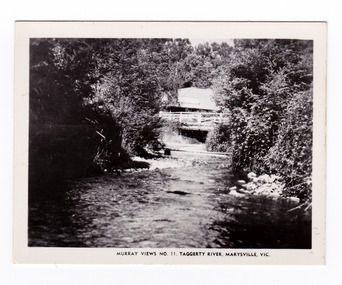 Marysville & District Historical Society
Photograph (item) - Black and white photograph, Murray Views, Murray Views No. 11. Taggerty River, Marysville, Vic, Post 1929
An early black and white photograph of the Steavenson River in Marysville, Victoria.An early black and white photograph of the Steavenson River in Marysville, Victoria. The Steavenson Falls is named after the Victorian Assistant Commissioner of Roads and Bridges, John Steavenson who arrived here in the early 1860s. This photograph was published by Murray Views in Gympie, Queensland, as a souvenir of Marysville.marysville, victoria, photograph, murray views, souvenir, steavenson river, john steavenson -
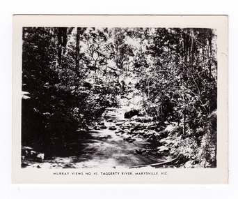 Marysville & District Historical Society
Photograph (item) - Black and white photograph, Murray Views, Murray Views No. 45. Taggerty River, Marysville, Vic, Post 1929
An early black and white photograph of the Taggerty River in Marysville, Victoria. An early black and white photograph of the Taggerty River in Marysville, Victoria. This photograph was produced by Murray Views in Gympie, Queensland as a souvenir of Marysville.taggerty river, marysville, victoria, murray views, photograph, souvenir -
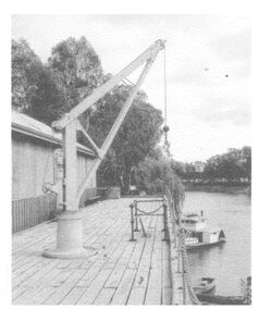 Wodonga & District Historical Society Inc
Photograph - The River Port of Red Bank
THE RIVER PORT OF REDBANK During the 1870s, Red Bank would have been one of the busiest ports on the Murray River. When the railway line was being built from Melbourne to Wodonga all the railway material was brought up river from Echuca by paddle steamer and barge and unloaded at Red Bank. The material was loaded onto horse teams or bullock wagons and taken along the route of the spur line. During the 187 MacCulloch & Co. handled 3000 tons of railway material here' The port was operational from approximately 1870 until 1874. THE FIG TREES The fig trees and a small bank of gravel are the only visible reminders of where the spur line from the wharf at Red Bank met the main line. It was at this point that all the material for the mainline was transferred from the small locomotives and wagons from Red Bank. It would have been carried by bullock wagons and horse teams and unloaded at different places as the line progressed. After the line was completed in 1873 the fettlers from Wodonga would patrol this length of the line.These images are significant because they document an important stage in the development of transportation in North East Victoria.Images of the River Port of Red bank near Wodonga on the Murray River. 1. The wharf 2. All that remainsred bank port, historic wharf wodonga, river transport -
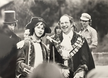 Kew Historical Society Inc
Photograph, Standard Newspapers, Charles Grimes Re-enactment, Yarra River, 1978
The party of the British surveyor Charles Grimes were the first Europeans to view the River Yarra, as it was later to be named. Members of the party reached the area now known as Studley Park in 1803. This local re-enactment commemorated 175 years since that event. Charles Grimes Re-Enactment, Yarra River, Kew, 1978. The photograph is of a student of Trinity Grammar School and the Mayor of Kew, Cr. Whiting. Inscription on reverse: "KH-161. Society's contribution to the 1978 Festival of Kew. Re-enactment of first white man's journey and discovery of the Yarra River and the area now know (sic) as Kew. 1978. This was in the year 1903 when Grimes and party came upon the Yarra to seek a possible site for a new convict settlement. Cr. Whiting, Mayor of Kew, receiving the report from Grimes, 'Andrew Allen'. Cr. Hutchinson in top hat 'town cryer'. Bush band in backround." Ripped stamp on reverse: "Standard N[ewspapers]."charles grimes re-enactment, trinity grammar school, cr whiting -- mayors -- kew (vic.), yarra river, andrew allen, kew historical society