Showing 272 items matching "river transport"
-
 Port of Echuca
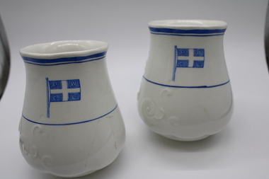
Decorative object - Permewan Wright Vase
... ...river transport...The company dominated the river trade in Echuca during the 1880s and 1890s, operating a fleet of steamers on the Murray, Murrumbidgee and Edwards Rivers. permewan wright river transport permewan Wright building permewan wright flag Decorative Scrolls embossed on one side. ...Permewan Wright & Co Ltd were one of the biggest shipping agents on the Murray in the 2nd half of the 19th century. They were a cartage company established in 1856 in Geelong, who opened one of its twenty Victorian branches at Echuca in 1875. The company dominated the river trade in Echuca during the 1880s and 1890s, operating a fleet of steamers on the Murray, Murrumbidgee and Edwards Rivers.Off White Vase with blue decorative Permewan Wright Co Flag. Thin blue lines encircled at top and middle. Slightly scalloped opening.Decorative Scrolls embossed on one side. permewan wright, river transport, permewan wright building, permewan wright flag -
 Charlton Golden Grains Museum Inc
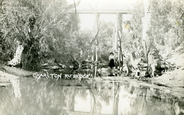
Postcard, Charlton Rly Bridge, c.1890
... River...Transport...Charlton Railway Bridge Avoca River Transport Charlton Rly Bridge. Standard sepia postcard without a border. ...View from Avoca River of Charlton Railway Bridge. Looking along the Avoca River to the railway bridge overhead. Two girls standing on the banks of the river. The river is low and many stumps and log are visible. c.1890.Standard sepia postcard without a border.Charlton Rly Bridge.charlton, railway bridge, avoca river, transport -
 Port Melbourne Historical & Preservation Society
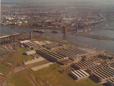
Photograph - Aerial view of West Gate Bridge under construction, 1960 - 1979
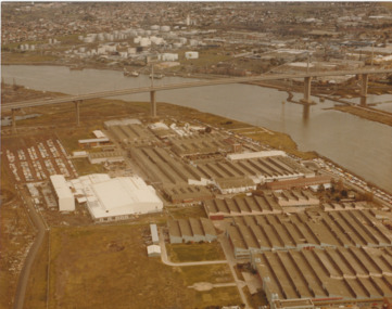
... River...Transport - Shipping...Port Melbourne Historical & Preservation Society Port Melbourne Town Hall 333 Bay Street Port Melbourne melbourne Engineering - Bridges Fishermans Bend Built Environment - Industrial West Gate Bridge Rotten Row Piers and Wharves - MHT Timber Wharves Williamstown Yarra River Transport - Shipping Transport - Roads Commonwealth Aircraft Corporation Government Aircraft Factory "Master copy. ...Colour aerial photograph of West Gate Bridge under construction. Fishermans Bend factories in foreground. Ship in the river and view to Spotswood, Newport and Williamstown."Master copy. Not to be removed from marketing Department" stamped on top right corner and on backengineering - bridges, fishermans bend, built environment - industrial, west gate bridge, rotten row, piers and wharves - mht timber wharves, williamstown, yarra river, transport - shipping, transport - roads, commonwealth aircraft corporation, government aircraft factory -
 Port Melbourne Historical & Preservation Society
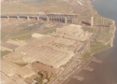
Photograph - Aerial view of West Gate Bridge under construction, 1960 - 1979
... River...Transport - Shipping...Port Melbourne Historical & Preservation Society Port Melbourne Town Hall 333 Bay Street Port Melbourne melbourne Engineering - Bridges Fishermans Bend Built Environment - Industrial West Gate Bridge Rotten Row Piers and Wharves - MHT Timber Wharves Yarra River Transport - Shipping Transport - Roads Commonwealth Aircraft Corporation Government Aircraft Factory "Master Copy . ...Colour aerial (faded) photograph of West Gate Bridge under construction with two land spans incomplete. "Rotten Row" (disused old piers original constructed in 1889 by MHT) in the foreground. Aircraft factory and other industry in foreground."Master Copy . Not to be removed from Marketing department " lightly stamped on photo. and on rearengineering - bridges, fishermans bend, built environment - industrial, west gate bridge, rotten row, piers and wharves - mht timber wharves, yarra river, transport - shipping, transport - roads, commonwealth aircraft corporation, government aircraft factory -
 Port Melbourne Historical & Preservation Society
Photograph - Aerial view of West Gate Bridge under construction, c1979
... River...Transport - Roads...Engineering - Bridges Fishermans Bend Built Environment - Industrial West Gate Bridge Yarra River Transport - Roads Piers and Wharves - MHT Timber Wharves Rotten Row Demolitions Commonwealth Aircraft Corporation Government Aircraft Factory "Gov't A/C Factories Photographic Section Neg No N2841/3" stamped on back Colour aerial photograph of West Gate Bridge completed. ...The wharf part of "Rotten Row" can be seen along the river bank in this photograph however the finger jetties visible in earlier photographs (3662.01 and 3662.02) have been removed.Colour aerial photograph of West Gate Bridge completed. Aircraft factory and other industry in foreground. Spotswood and Newport and fuel storage tanks in background."Gov't A/C Factories Photographic Section Neg No N2841/3" stamped on backengineering - bridges, fishermans bend, built environment - industrial, west gate bridge, yarra river, transport - roads, piers and wharves - mht timber wharves, rotten row, demolitions, commonwealth aircraft corporation, government aircraft factory -
 Orbost & District Historical Society
black and white photograph, 1934
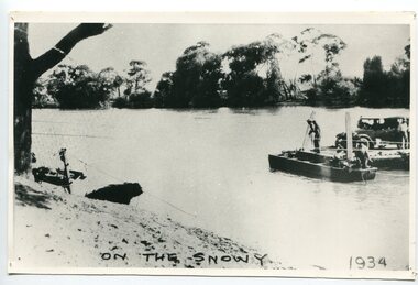
... Snowy-River-Orbost flood-1934 river-transport-punt...Snowy-River-Orbost flood-1934 river-transport-punt on front - "On the Snowy 1934" A large black / white photograph of a punt with a motor vehicle and people making their way across a river. black and white photograph ...This photograph shows vehicles and people being ferried across the Snowy River during the 1934 flood. The Orbost punt was reinstated on a temporary basis following damage to the bridge. Damage estimated at £500,000 was caused by the 1934 floods in the Orbost district. This 1934 flood was devastating, destroying a section of the 1922 Orbost bridge, wrecking fences, bridges and roads, dumping silt and debris on the rich river flats and drowning cattle. The centre span of the Orbost Bridge was washed away.This is a pictorial record of the effects of the 1934 floods in the Orbost district.A large black / white photograph of a punt with a motor vehicle and people making their way across a river.on front - "On the Snowy 1934"snowy-river-orbost flood-1934 river-transport-punt -
 Wodonga & District Historical Society Inc
Photograph - The River Port of Red Bank
... ...River transport...Red Bank Port Historic wharf Wodonga River transport Images of the River Port of Red bank near Wodonga on the Murray River. 1. ...THE RIVER PORT OF REDBANK During the 1870s, Red Bank would have been one of the busiest ports on the Murray River. When the railway line was being built from Melbourne to Wodonga all the railway material was brought up river from Echuca by paddle steamer and barge and unloaded at Red Bank. The material was loaded onto horse teams or bullock wagons and taken along the route of the spur line. During the 187 MacCulloch & Co. handled 3000 tons of railway material here' The port was operational from approximately 1870 until 1874. THE FIG TREES The fig trees and a small bank of gravel are the only visible reminders of where the spur line from the wharf at Red Bank met the main line. It was at this point that all the material for the mainline was transferred from the small locomotives and wagons from Red Bank. It would have been carried by bullock wagons and horse teams and unloaded at different places as the line progressed. After the line was completed in 1873 the fettlers from Wodonga would patrol this length of the line.These images are significant because they document an important stage in the development of transportation in North East Victoria.Images of the River Port of Red bank near Wodonga on the Murray River. 1. The wharf 2. All that remainsred bank port, historic wharf wodonga, river transport -
 Kew Historical Society Inc
Photograph - Port of Melbourne, circa 1953
... river...transport...The series includes images of individuals, tea rooms, ferries, motor launches, ocean liners and tugs. tugboats melbourne yarra river transport shipping maribyrnong river Evocative, faded black and white photographic positive proof of a tugboat, ocean liner and docks in the Port of Melbourne. ...This is one of a series of 17 black and white undated photographic proofs donated to the Kew Historical Society in 2013 by the Queenscliffe Historical Museum. The series includes images of individuals, tea rooms, ferries, motor launches, ocean liners and tugs. Evocative, faded black and white photographic positive proof of a tugboat, ocean liner and docks in the Port of Melbourne. The undated photographic positive was probably taken in the 1950s.tugboats, melbourne, yarra river, transport, shipping, maribyrnong river -
 Bendigo Historical Society Inc.
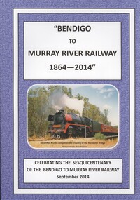
Book - BENDIGO TO MURRAY RIVER RAILWAY
... Bendigo-Railways-Murray River Railways-Transport...History House 11 Mackenzie Street Bendigo goldfields BOOK Rural railway Bendigo-Railways-Murray River Railways-Transport Esma Turner Bendigo to Murray River Railway 1864 - 2014, celebrating the sesquicentenary of the Bendigo to Murray river railway September 2014. ...Bendigo to Murray River Railway 1864 - 2014, celebrating the sesquicentenary of the Bendigo to Murray river railway September 2014. Soft cover with 198 pages with black & white and colour photos, compiled by the Historical & Genealogical Societies of Northern Victoria, edited by esma Turner.Esma Turnerbook, rural, railway, bendigo-railways-murray river railways-transport -
 Orbost & District Historical Society
black and white photograph, late 19th - early 20th century
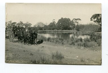
... Brodribb-River Snowy-River Marlo transport-horse-drawn...Brodribb-River Snowy-River Marlo transport-horse-drawn on back - "at the Brodribb - Snowy junction. this road was corduroy (packed logs of tea trees?) ...This photograph was taken at the junction of the Snowy and Brodribb Rivers. The Snowy River starts in New South Wales on the slopes of Mt Kosciuszko, Australia’s highest mountain, in New South Wales. It flows into Bass Strait at Marlo in Victoria. The Brodribb River is a tributary of the Snowy which enters the estuary at Marlo. This is a pictorial record of a road in Marlo near Orbost in the late 19th-early 20th centuries. It also depicts the transport used at that time.A black / white photograph of four men in suits seated in a horse - drawn buggy on a dirt road alongside a creek or river. There appears to be another horse - drawn vehicle behind them.on back - "at the Brodribb - Snowy junction. this road was corduroy (packed logs of tea trees?)brodribb-river snowy-river marlo transport-horse-drawn -
 Orbost & District Historical Society
black and white photograph, first half 20th century
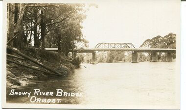
... Orbost Snowy-River-bridge transport-bridge...Orbost Snowy-River-bridge transport-bridge on front bottom left - "SNOWY RIVER BRIDGE" A black / white photograph / postcard of a bridge over a river. ...This is a photograph of the second Snowy River Bridge at Orbost. The section in the central span could have been built after flood damage. This bridge over the Snowy River was opened on July 4 1922. It was constructed in 1922 alongside the previous suspension bridge. Its building was a combined effort of the Victorian Railways and the Country Roads Board at a cost of 35,000 pounds. It was replaced in 1976 by the present bridge after several major floods.This bridge was replaced in 1976 after several major floods.A black / white photograph / postcard of a bridge over a river. It has what looks like a bo girder in the central section. On the left is the river bank.on front bottom left - "SNOWY RIVER BRIDGE"orbost snowy-river-bridge transport-bridge -
 Orbost & District Historical Society
black and white photograph, late 19th century
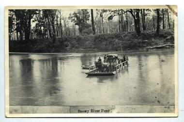
... snowy-river-orbost transport shipping...(info, from Victorian Places Orbost) This item is associated with the Snowy River and its history. It is a pictorial record of transport in the late 19th century. snowy-river-orbost transport shipping on front at bottom - "Snowy River Punt" A black / white photograph (copy) of a punt loaded with people and a horse-drawn carriage making its way across a river. black and white photograph ...A punt crossed the Snowy River at Orbost from 1884. A bridge was constructed in 1893, but was soon damaged by a huge flood. Flooding was a regular occurrence, the worst inundations being in 1870, 1893, 1925, 1934, 1952 and 1971. Over the years major flood protection works have been implemented. The Princes Highway, which passes Orbost, now crosses the flood plain on raised concrete supports. (info, from Victorian Places Orbost)This item is associated with the Snowy River and its history. It is a pictorial record of transport in the late 19th century.A black / white photograph (copy) of a punt loaded with people and a horse-drawn carriage making its way across a river.on front at bottom - "Snowy River Punt"snowy-river-orbost transport shipping -
 Kew Historical Society Inc
Photograph - Motor launch at Princess Walk, circa 1953
... river...tourism...transport...Historically significant and rare image of one of the major tour boat services which operated on the Yarra River. tugboats melbourne motor launches ferries hawthorn tea rooms hicks bros launches princess walk yarra river tourism transport Faded black and white photographic positive proof of a moto launch (tourist ferry) at Princess Walk. ...Commercially-operated boat tours on the Maribyrnong and Yarra Rivers in Melbourne were a major tourist attraction, especially in the first half of the twentieth century. A number of companies ran ferries and motor-launches to locations such as the Riverview Tea Gardens (1909-1947) at Ascot Vale, and the Hawthorn Tea Gardens on the corner of Power Street and Riversdale Road. One of the families which ran these services was Hicks Bros, which from circa 1921 operated a ferry service from Princess Walk (Melbourne) to Studley Park. This is one of a series of 17 black and white undated photographic proofs donated to the Kew Historical Society in 2013 by the Queenscliffe Historical Museum. The series includes images of individuals, tea rooms, ferries, motor launches, ocean liners and tugs. In 1953, the owner of Hicks Bros was involved in an inquest into the drowning of a Ukrainian tourist on a ferry operated by Melbourne Ferries, a rival firm. In published reports of the inquest, reference is made to a number of photographs taken by Robert Irvine Atchison, part-owner of Hicks Bros. As the reverse of the photographs indicates copyright is held by the State of Victoria, the collection may have derived from that year.Historically significant and rare image of one of the major tour boat services which operated on the Yarra River.Faded black and white photographic positive proof of a moto launch (tourist ferry) at Princess Walk. The undated photographic positive was probably taken in the 1950s.tugboats, melbourne, motor launches, ferries, hawthorn tea rooms, hicks bros launches, princess walk, yarra river, tourism, transport -
 Port Melbourne Historical & Preservation Society
Photograph - Yarra River, Ron Laing, 1990s
... river...built environment...transport...The Bolte Bridge which caused this closure of Victoria Dock, North and South Wharves is covered in photos 1319.01-.35. yarra river built environment transport - shipping ron laing A set of 47 colour photogaphs of the Yarra River at various locations from the old Sandridge Railway Bridge westward to the power house at Newport Photograph Yarra River Ron Laing ...Part of Ron Laing's collection of photographs recording Port Melbourne over a thirteen year period. Donated to the PMH&PS by the photographer. nb Includes photographs of Victoria Dock in the period of time after the commercial shipping had gone but before the start of the proposed high-rises. The Bolte Bridge which caused this closure of Victoria Dock, North and South Wharves is covered in photos 1319.01-.35.A set of 47 colour photogaphs of the Yarra River at various locations from the old Sandridge Railway Bridge westward to the power house at Newportyarra river, built environment, transport - shipping, ron laing -
 Orbost & District Historical Society
black and white photograph, first half 20th century
... bridge Snowy-River-Bridge road-transport-Orbost...This is a pictorial record of an early bridge across the Snowy River at Orbost. bridge Snowy-River-Bridge road-transport-Orbost A very large black / white photograph under glass in a timber frame. ...This is a bridge across the Snowy River at Orbost. This bridge was built in the 1920s as a road and rail bridge, and was partly washed away by flood waters in 1934. After the end of the first World War the Victorian Railways considered an extension of the railhead across the river at Orbost, and in 1922 a new timber and steel girder structure, a joint Country Roads Board — Victorian Railways venture, was built and completed at a cost of £41,000 (the steel girders came from the Flinders Street viaduct reconstruction). Subsequently it was decided not to take the railway across the river, and the bridge has only been used by road traffic.This is a pictorial record of an early bridge across the Snowy River at Orbost.A very large black / white photograph under glass in a timber frame. It is of a bridge across a river and is framed by trees.bridge snowy-river-bridge road-transport-orbost -
 Port Fairy Historical Society Museum and Archives
Photograph
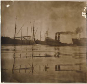
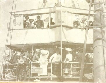
... river...s.s.casino 1910...transport...Transport of the large quantities of wool, potatoes, onions, grain, sheep, cattle and other produce grown on the rich lands of the Western District Belfast was served by a plethora of shipping, both sail and steam, but only one of the steamers then in the regular trade (S.S. DAWN) would ever be able to get up the river...Disaster struck soon after 9 o'clock on the morning of Sunday I0 July, 1932 when the CASINO was lost at Apollo Bay together with the lives of 10 crew members. ship boat sea river s.s.casino 1910 transport 1910 wool onions grain sheep cattle steam Terang day Black and white photograph of tourists crowded on the decks of s.s.Casino during a sail around the bay for Terang day Photograph Photograph ...S.s.Casino 1910. The people on the decks are tourists coming from Terang and surrounding areas to spend the day at the seaside. The steamer S.S.CASINO was much loved by the whole Port Fairy community- with the possible exception of some of the fishermen whose boats she ran down! Transport of the large quantities of wool, potatoes, onions, grain, sheep, cattle and other produce grown on the rich lands of the Western District Belfast was served by a plethora of shipping, both sail and steam, but only one of the steamers then in the regular trade (S.S. DAWN) would ever be able to get up the river and reap the cost savings of loading against a wharf. It was not unusual for four steamers to be anchored in the bay at once and for seven or eight different steamers to call during a week. A number of inter-colonial steamers also called to pick up produce for delivery to Melbourne, Sydney and Adelaide. Production in the Western District was increasing and virtually all of that production had to go through one of the western ports in order to reach markets. By 1882 a meeting 15ft. March, 1882, in the office of auctioneer, J.B. HoIden in Cox Street took action and it was unanimously resolved - that the Belfast & Koroit Steamship Company be formed with a capital of £20,000 in 10,000 shares of £2 each". A number of steamers were offered by letter to the fledgling company, including the new and almost sister ships, CASINO and HELEN NICHOLL. The CASINO was on her delivery voyage from England was due to arrive in Warrnambool to load potatoes for Sydney and, initially, arrangements were made for her to call into Port Fairy for inspection by the BKNS Co directors. She eventually proceeded direct to Warrnambool and the Directors inspected her there. Without hesitation they purchased her even though they had to raise a large bank loan to do so. The CASINO arrived in Port Fairy on Saturday, 29th. July, 1882, steaming triumphantly up the Moyne River, and was greeted by crowds, many of whom had driven in from the surrounding countryside, which gave her “loud ringing English cheers". By 1884 the CASINO could not carry all the cargoes available to her and in December of that year the company purchased the new steamer BELLINGER to provide additional capacity. She helped to open up the intermediate ports of Lorne, Apollo Bay and Port Campbell, but the BELLINGER was not really suitable for the trade and she was sold in 1887, leaving the CASINO to operate alone -as she was to do for almost all of the next 45 years. The opening of the railway in 1890 decreased the cargo available to the steamers and the economic depression of the early 1890's worsened the situation. The weak soon began to fall by the wayside and when the Portland & Belfast SN Co. decided to go into liquidation in April 1895, the Belfast & Koroit Company bought the Portland Company's steamer DAWN on advantageous terms, a substantial part of the payment being in BKSN Co shares. The BKNS Co and the Howard Smith Line came into direct head to head competition and nearly forced the BKNS Co out of existence. Cargo dropped to such an extent that in 1899, they reached agreement that only one ship would run and that the ship which ran would pay a weekly amount to the competitor to stay out of the trade. This controlled service ceased in1909, and competition intensified when Howard Smith placed the newly built, larger steamer EUMERALLA on the run. The BKNS Co survived this competition and even prospered during it partly by extending on a more regular basis, the CASINO'S voyages to South Australian ports Port Macdonnell, Kingston, Beachport, Robe and, on occasions Adelaide. There were setbacks when, on 20 October 1924, CASINO went ashore at the Kennett River, near Apollo Bay, and again, in February l929, when she struck a submerged object at Warrnambool and had to be beached. The railways placed great competitive pressure on the small steamship company and this pressure was intensified when the Great Depression slashed the market for Western District produce, BKNS Co struggled on, paying dividends in most years, and the company planned a big celebration for the CASINO'S fiftieth anniversary in the trade on 29th July, 1932. Disaster struck soon after 9 o'clock on the morning of Sunday I0 July, 1932 when the CASINO was lost at Apollo Bay together with the lives of 10 crew members. Black and white photograph of tourists crowded on the decks of s.s.Casino during a sail around the bay for Terang dayship, boat, sea, river, s.s.casino 1910, transport, 1910, wool, onions, grain, sheep, cattle, steam, terang day -
 Orbost & District Historical Society
postcard, Vogt. W.S, first half 20th century
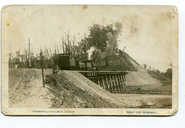
... This meant the end of river transport for the area. The railway was opened on April 10 1916 and closed in 1987. ...This meant the end of river transport for the area. The railway was opened on April 10 1916 and closed in 1987. ...This photograph is of a train on the small rail bridge which crosses over the Burn Road Newmerella cutting. In 1912 work was underway to complete the Bairnsdale to Orbost section of the railway. This meant the end of river transport for the area. The railway was opened on April 10 1916 and closed in 1987. The letter written on the card is from Hilda Graham to her uncle.This item is associated with the history of the Orbost-Bairnsdale railway line and therefore reflects the role that the rail line played in the social and economic history of Orbost.A black / white postcard photograph showing a train engine crossing on a small rail bridge. On the back is a handwritten letter.Photo caption - "NEWMERELLA RAILWAY, ORBOST STANLEY VOGT"newmerella east-gippsland-railway -
 Sunshine and District Historical Society Incorporated
Administrative record - City of Sunshine - Commissioner Mr Alexander Alex George Gillon Collection 1976 - 1982 - Report of committee meetings 12th August 1980, City of Sunshine, 19th August 1980
... Planning Application Protean Boundary Road corner Fitzgerald Road Dempster Park full title Braybrook High School netball court marking Sunshine Heights Football Club broken windows account payment Sunshine Swimming and Life Saving Club Maribyrnong River Transport Sunshine West improvement request Humes Pipes Land Car Parking Watt Street Vic Rail Housing Estate Fun Run Sunshine Amateur Athletics Club Motorcycle Track request Reinstatement of nature strip 14 Ernest Street Sunshine Choral Society Footpath damage 2 Syleham Street...Albans Planning Application Protean Boundary Road corner Fitzgerald Road Dempster Park full title Braybrook High School netball court marking Sunshine Heights Football Club broken windows account payment Sunshine Swimming and Life Saving Club Maribyrnong River Transport Sunshine West improvement request Humes Pipes Land Car Parking Watt Street Vic Rail Housing Estate Fun Run Sunshine Amateur Athletics Club Motorcycle Track request Reinstatement of nature strip 14 Ernest Street Sunshine Choral Society Footpath damage 2 Syleham Street Foolscap sized document. ...Planning Application Protean Boundary Road corner Fitzgerald Road Dempster Park full title Braybrook High School netball court marking Sunshine Heights Football Club broken windows account payment Sunshine Swimming and Life Saving Club Maribyrnong River Transport Sunshine West improvement request Humes Pipes Land Car Parking Watt Street Vic Rail Housing Estate Fun Run Sunshine Amateur Athletics Club Motorcycle Track request Reinstatement of nature strip 14 Ernest Street Sunshine Choral Society Footpath damage 2 Syleham Streetprotean, bounrdary road, fitzgerald road, berrimut, dempster park, phoenix street, sunshine north, braybrook high school, ballarat road, braybrook, sunshine heights football club, vernon crescent, sunshine west, sunshine swimming and life saving club, maribyrnong river, humes pipes land, van ness avenue, maribyrnong, watt street, sunshine, sunshine amateur athletics club, ernest street, sunshine choral society, syleham street, st. albans -
 Warrnambool and District Historical Society Inc.
Document - Ledger, Standard Articles, Mid 20th century
... The subject matter includes the Post and Telegraph Office, Punts over the Merri and Hopkins Rivers, Transport in the Early Days, Early Exploration, Minjah Station and the History of the Breakwater. ...The subject matter includes the Post and Telegraph Office, Punts over the Merri and Hopkins Rivers, Transport in the Early Days, Early Exploration, Minjah Station and the History of the Breakwater. ...This ledger contains original Warrnambool Standard newspaper cuttings of the eleven articles written by Henri Worland on the early history of Warrnambool. The subject matter includes the Post and Telegraph Office, Punts over the Merri and Hopkins Rivers, Transport in the Early Days, Early Exploration, Minjah Station and the History of the Breakwater. Henri Worland (1883-1972) was Warrnambool’s most important 20th century local historian. He was the Town Clerk of Warrnambool from 1918 to 1949 and his intense interest in Warrnambool’s history led him to collect and preserve a great amount of local history material. He wrote extensively on Warrnambool’s history and gave talks on the local radio station over a period of many years.These newspaper cuttings are of interest as examples of the many local history articles written by the important Warrnambool historian Henri Worland. The Warrnambool and District Historical Society has a collection of Worland’s original writings in his own handwriting. This is a ledger book with a brown-coloured cover with red binding. There is a label pasted on to the front cover with black printing on it. The ledger has indented alphabet tabs and the pages are ruled with red lines for ledger purposes but these have not been used. The ledger has been used to paste in original cuttings from the Warrnambool Standard newspaper (Henri Worland articles from the 1940s). One page contains two copies of old photographs. Some of the pages have been reinforced with staples and some pages have become detached from the binding. ‘Ledger’ henri worland, history of warrnambool -
 Orbost & District Historical Society
black and white photograph, before 1912
... Bull) At the start of the river trade goods were shipped from Marlo to Melbourne but when the railway reached Bairnsdale this became unprofitable and the ships plied only between Marlo and Cunninghame. Eventually river transport became economically unviable. The Wongrabelle is still buried in the sands of the entrance of the Snowy River (albeit where the entrance used to be). ...Bull) At the start of the river trade goods were shipped from Marlo to Melbourne but when the railway reached Bairnsdale this became unprofitable and the ships plied only between Marlo and Cunninghame. Eventually river transport became economically unviable. The Wongrabelle is still buried in the sands of the entrance of the Snowy River (albeit where the entrance used to be). ...This photo shows the Storm Bird at the end of the jetty and the Wangrabelle in the foreground. Both ships were well known traders. the Wangrabelle became beached and wrecked in 1916 and the Storm Bird became obsolete when the railway from Bairnsdale to Orbost arrived in 1916. (ref. Story of Gippsland Shipping - J.C. Bull) At the start of the river trade goods were shipped from Marlo to Melbourne but when the railway reached Bairnsdale this became unprofitable and the ships plied only between Marlo and Cunninghame. Eventually river transport became economically unviable. The Wongrabelle is still buried in the sands of the entrance of the Snowy River (albeit where the entrance used to be). It took from April 11th 1912 to August 12th 1912 for the loss of the Wongrabelle to be complete, the final entry in the Orbost Shipping Co. records reads:- "The Wongrabelle is completely covered in sand." (ref River, Road, Railway Newsletter O.D.H.S.) This is a pictorial record of a time when the water highways were the only feasible transport mode in sending goods from Orbost and Marlo to Melbourne.A black / white photograph of a ship, sails down, anchored at the Marlo jetty.on back - "M. Gilbert, Wangrabelle at Marlo"storm-bird wangrabelle shipping transport- marlo -
 Orbost & District Historical Society
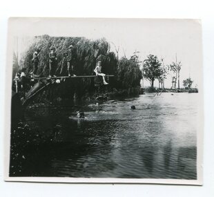
Photograph, 1920s-1950s
... From the earliest days of white settlement in the Orbost district, people used the Snowy River for recreation and transport. A local swimming hole was adjacent to the butter factory and was a deep hole. ...From the earliest days of white settlement in the Orbost district, people used the Snowy River for recreation and transport. A local swimming hole was adjacent to the butter factory and was a deep hole. ...From the earliest days of white settlement in the Orbost district, people used the Snowy River for recreation and transport. A local swimming hole was adjacent to the butter factory and was a deep hole. The diving board has been improvised. This photo appears to date from c.1920-1940s. The 50 metres swimming pool was constructed in the 1960s following a huge community campaign. This photo is significant because it shows the use of the Snowy River as a recreation resource prior to the construction of a community swimming pool. A b/w photo of a group of children, three swimming and five on a diving board. One at the end of the diving board has a swimming costume, others are fully dressed. This is 'THE BIG HOLE' on the Snowy just beyond the butter factory. Water about 8ft. deep straight off the bank. We were all very good swimmers and played there for hours and hours."swimming, snowy river, recreation -
 Orbost & District Historical Society
black and white photograph, C1890
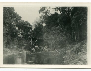
... "The snaggers played an important part in making the river free for transport. By 1880 Captain Collins, R McNair engineer, J McNair and the two Winchesters were at work with a punt on the Snowy and Brodribb. ..."The snaggers played an important part in making the river free for transport. By 1880 Captain Collins, R McNair engineer, J McNair and the two Winchesters were at work with a punt on the Snowy and Brodribb. ...This snagging team is on the Brodribb River, east of Orbost. The Brodribb bridge can be seen in the background of the Photograph. The Snowy River was used for commercial navigation after 1880 and extensive de-snagging A shipping company was formed in 1880, poling barges upstream until the removal of large trees and branches that had fallen into the river was carried out to make the river upstream of Marlo easier to navigate. "The snaggers played an important part in making the river free for transport. By 1880 Captain Collins, R McNair engineer, J McNair and the two Winchesters were at work with a punt on the Snowy and Brodribb. Mr. Jim Winchester took charge soon after. Early snaggers were Johnston, J Renton, Nat Lynch, John Drew, Hatton, J Scott and Harry Wilkinson. The system used was to use a tree on the river bank as a lever and with heavy manila ropes, slowly to haul the snags out. They were piled up around a tree and burned when dry. The snaggers lived in a row of cottages in Snaggers’ Lane." (info. John Phillips Newsletter March 2004)The snaggers played an important role in the early settlement of the Orbost / Marlo district helping bto open it up to commercial shipping.Two copies of a black / white photograph of nine men on a snagging boat, a flat-bottom barge. In the background is a bridge.on back - "Snagging boat on Brodribb with R.McNair"snaggers-brodribb-river snagging-east-gippsland transportation -
 Bendigo Military Museum
Photograph - Royal Australian Survey Corps Surveyors in the Field – North Queensland and Torres Strait, 1961
... In photo .2P Joe Farrington is seen taking survey observations using a Tavistock V500 Series Tavistock theodolite at a survey station between the Edward River and Aurukun in the Cape York Peninsula. The Gulf of Carpentaria appears in the background. From 1957 helicopter transport of survey parties revolutionised transport in remote areas. ...In photo .2P Joe Farrington is seen taking survey observations using a Tavistock V500 Series Tavistock theodolite at a survey station between the Edward River and Aurukun in the Cape York Peninsula. The Gulf of Carpentaria appears in the background. From 1957 helicopter transport of survey parties revolutionised transport in remote areas. ...This is a set of five photographs of surveyors and support staff in the field undertaking duties in North Queensland and Torres Strait in 1961. The surveyors were employed in the establishment of mapping and geodetic control. In this era surveyors used theodolites to observe horizontal and vertical angles and tellurometers to measure base line distances between survey stations. In photo .2P Joe Farrington is seen taking survey observations using a Tavistock V500 Series Tavistock theodolite at a survey station between the Edward River and Aurukun in the Cape York Peninsula. The Gulf of Carpentaria appears in the background. From 1957 helicopter transport of survey parties revolutionised transport in remote areas. The civilian helicopter was hired from TAA. This is a set of five photographs of surveyors and support staff in the field undertaking duties in North Queensland and Torres Strait in 1961. The photographs were printed on photographic paper and are part of the Army Survey Regiment’s Collection. The photographs were scanned at 300 dpi. .1) - Photo, colour, 1961. Andy Millar occupying a survey station on a hill in the Cape York Peninsula, QLD. .2) - Photo, colour, 1961. Joe Farrington taking observations with a V500 Series Tavistock geodetic theodolite at a survey station in the Cape York Peninsula, QLD. .3) - Photo, colour, 1961. Daryl Parker taking a break from survey observations on a hill located on Duaun Island QLD, in the Torres Strait, a few miles south of the PNG coastline. Hill height was 975 ft. .4) - Photo, colour, 1961. Three Torres Strait divers L to R: unidentified, Darku and Ray Mau Daryl standing behind a Tavistock geodetic theodolite on a hill located on Duaun Island QLD, in the Torres Strait, a few miles south of the PNG coastline. .5) - Photo, colour, 1961. Andy Millar holding meat from a small turtle on Duaun Island QLD, in the Torres Strait, a few miles south of the PNG coastline. An unidentified Duaun Island local appears in the background..1P to .5P annotated on back – personnel names, the year and the location. royal australian survey corps, rasvy, army survey regiment, asr, army svy regt, fortuna, surveying -
 Kiewa Valley Historical Society
Four photographs of the Blue Duck Hotel and two Photos of the Glen Wills area, c1920 Post cards, c1949/50 small photographs
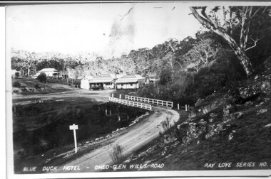
... rivers - Cobungra, Bundarra and Mitta Mitta, called Angler's Rest. The original 1900's building was of slab construction and operated as a butcher shop, servicing miners on the track from Omeo to Mt. Wills. In 1912 it was purchased by a miner, Billy O'Connell, and he obtained a hotel license. In the early 1920's he transported...rivers - Cobungra, Bundarra and Mitta Mitta, called Angler's Rest. The original 1900's building was of slab construction and operated as a butcher shop, servicing miners on the track from Omeo to Mt. Wills. In 1912 it was purchased by a miner, Billy O'Connell, and he obtained a hotel license. In the early 1920's he transported ...The Blue Duck Hotel stands at the confluence of 3 trout rivers - Cobungra, Bundarra and Mitta Mitta, called Angler's Rest. The original 1900's building was of slab construction and operated as a butcher shop, servicing miners on the track from Omeo to Mt. Wills. In 1912 it was purchased by a miner, Billy O'Connell, and he obtained a hotel license. In the early 1920's he transported 2 houses from Omeo on Horse drays. One is the main building of the Blue Duck and the other was a residence where Billy and his wife raised their nine children. The small log structure behind the pub is State School No.4286 where the children attended school. A teacher was shared with Glen Wills. By the late 1920's the hotel was discovered and patronized by keen anglers. Sir Harold Clapp (head of the railways) was one and he had the bronze blue duck cast and presented to the owners in the 1930's. This stands at the entrance to the premises.These photographs are of a building, in a remote area, that has provided a service to miners, anglers and travellers for over 100 years and continues to do so today. It also played a vital role in the history of the Mt. Wills/Omeo gold mining days.3 Post cards, Black and White photographs. 3 small black and white photographsPost Card No. 1 - "Blue Duck Hotel- Omeo-Glen wills road Ray Love Series No.2"(written on lower front) Post Card No. 2- "Looking towards Bogong High Plains. Omeo-Glen Wills road"(front, bottom, L hand) Ray Love Series No. 18 (front, lower R hand corner) On both of above photos, centre back, is stamped POST CARD and underneath this is printed "A GENUINE PHOTOGRAPH'/ Post Card No. 3 - Bottom L hand corner "Mystic Sea Australian Alps". R hand corner "(Bulmer Copyright)". Each small photograph, handwritten on back "Blue duck Hotel". All have circular stamp with "Print by Wilson White Albury" blue duck hotel; anglers rest; omeo highway; fishing; mining -
 Kiewa Valley Historical Society
Photographs- 1 old black and white photograph of a wooden bridge over a river possibly Ryders Bridge in Tawonga. 2 –Enlargement of the original photograph showing the gentleman leaning on the bridge. Taken off the original photo
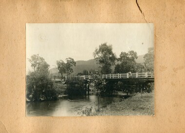
... River on Mountain Creek Rd Tawonga The first Tawonga bridge was built in 1884- destroyed by floods in 1916. New bridge constructed 1923 and destroyed in 1953. Present concrete bridge constructed in 1986 and named Ryders Bridge These wooden bridges were the only method for transporting stock and produce to market, transporting timber to the mills, sending and receiving mail and for local people to cross the many rivers in the area to go about their daily business. ...The bridge is not definitively identified, but is of similar construction style to other bridges built in rural areas around this time. Circa 1930”s and may be Ryders Bridge (Old Tawonga Bridge) which crosses the Kiewa River on Mountain Creek Rd Tawonga The first Tawonga bridge was built in 1884- destroyed by floods in 1916. New bridge constructed 1923 and destroyed in 1953. Present concrete bridge constructed in 1986 and named Ryders Bridge These wooden bridges were the only method for transporting stock and produce to market, transporting timber to the mills, sending and receiving mail and for local people to cross the many rivers in the area to go about their daily business. 1- Black and white photograph is glued onto heavy cardboard, which is yellowing with age. Top right hand corner has a tear in the cardboard. Photograph depicts a wooden bridge on wooden piles with 2 white wooden railings along the length of both sides. 2- Original photo has been digitally enlarged to show a gentleman in a light coloured suite and wearing riding boots leaning on the rails of the bridge. The bridge is not definitively identified, but is of similar construction style to other bridges built in rural areas around this time. Circa 1930”s may be Ryders Bridge (Old Tawonga Bridge) which crosses the Kiewa River on Mountain Creek Rd Tawonga bridge; tawonga bridge; kiewa valley -
 Kiewa Valley Historical Society
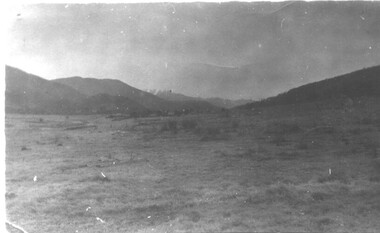
Book - Kiewa River, Stocking and Crossing the Kiewa River by Jan Hunter (nee Chick), 2020
... The photos are of the release of fingerling trout in the Kiewa River, thought to be at Keegan's Bridge. The fingerlings were transported in drums on the back of trucks. ...The photos are of the release of fingerling trout in the Kiewa River, thought to be at Keegan's Bridge. The fingerlings were transported in drums on the back of trucks. ...The Chick brothers, Alf, Les and Allan, plus friends, began trout fishing and camping in the Kiewa Valley before the early 1930s. Les continued his connection with the Kiewa River until his death in 1972. Fingerlings were placed in the Kiewa River from the early 1880s. Keegan's Bridge is a crossing near Upper Gundowring and about 4 km south east of Dederang. References to the crossing were made in the early 1900s and a petition presented to Council in 1904 calling for a bridge.The bridge was built and opened in 1907. The photos are of the release of fingerling trout in the Kiewa River, thought to be at Keegan's Bridge. The fingerlings were transported in drums on the back of trucks. The photos are c1940s.The Kiewa Valley has been a popular spot for fishermen, tourists and campers from the 1880s. One of the many attractions has been the excellent fishing along the Kiewa River due to the regular release of fish especially brown trout. This continues to the present day (2020) when a few fish were marked with $$ signs for the lucky fisherman who caught them. This attracts visitors, their families and boosts the economy and dates back to visits at the Tawonga Pub prior to the Kiewa Hydro Electric Scheme.19 page book with black plastic spine and clear plastic cover over the beige paper cover with title , author and black & white photo. Note: In KVHS photo collection there are 4 good quality reproduction photos on photographic paper. These have been produced professionally. These photos of Jan Hunter's are featured on the second page of her book. These also have a letter attached. The book is a pre-research paper & is No 33 of the Albury and District Historical Society Papers. The sub-title is "Trout releases and Keegan's Bridge / from the newpapers, 1882-1935"None on the book but a letter is attached from Jan Hunter, the author as a follow up to the photos she donated. On the photos - On the back: Fujifilm / Fujicolor Crystal Archive / Paper / Production - run codekiewa river; trout; fish; keegan's crossing; keegan's bridge; fingerlings; chick family; camping; tourism -
 Kiewa Valley Historical Society
Photograph - 30 black and white photographs (assorted sizes) plus page from a newspaper and copied article on A4 paper, c1880's c1910 - 1920 (photographs) Newspaper 1961
... river prior to land clearing for farming. K5 is of the Running Creek Cricket Team and therefore there was sufficient population in the area to form and maintain a team as well as have other teams in the relatively near vicinity to provide competition. Note the horse drawn cart which provided transport...river prior to land clearing for farming. K5 is of the Running Creek Cricket Team and therefore there was sufficient population in the area to form and maintain a team as well as have other teams in the relatively near vicinity to provide competition. Note the horse drawn cart which provided transport ...K2,3 and4 are of the Kiewa River and two of the bridges spanning the river along the valley. K3 and K4 would have been taken in the 1880's and show the type of trees and plant growth along the river prior to land clearing for farming. K5 is of the Running Creek Cricket Team and therefore there was sufficient population in the area to form and maintain a team as well as have other teams in the relatively near vicinity to provide competition. Note the horse drawn cart which provided transport. Date taken is unknown but possibly c 1910. The Mt. Buffalo Chalet was built in 1910 by the Victorian Government. It was Australia's first ski resort and has served generations of skiiers, hikers and families over the years. It was built for 3195 pounds and has had stories and wings added since and is the largest timber building in Australia. B4 is the earliest photo in this group as the garden is in early stages of development - the other photos show the growth of the shrubs and would be taken about c 1920. Note the cars and motor bikes. It closed in 2006. The other photos are of general interest only but interesting to see that there were donkey's grazing. There is no information as to their purpose on Mt. Buffalo. Four different Kiewa Valley families are represented in the photographs. Their descendants still live in the Valley and carry on the traditions of beef and dairy farming. Of particular interest is the photo of Miss Marjorie Clemence, the first School Teacher of Upper Gundowring School. Gundowring pastoral run was taken up in 1838 and occupied by framers in the 1860's. The area was known as Gundowring and Upper Gundowring. The Gundowring School was opened in 1871 and most likely the Upper Gundowring school would be built at the same time. It was School No. 2733 and situated in Boyd Road. It closed in 1953 when the Kiewa Consolidated School opened. The newspaper page describes the activities in which the local community of Kergunyah were in engaged in that period - Red Cross, Fire Brigade, cattle round up and some of the identities involved. The article photocopied from the Yackandandah times states that he (Norman Coad) "was sent to the Ovens District Hospital, Beechworth for treatment" which would mean that this was the closest hospital to the Kiewa Valley for emergencies in 1912.The Kiewa Valley photographs are of social significance showing two of the early bridges allowing the community easy access to both sides of the river and also the tree and plant growth before land clearing for farming. The photos of Mt. Buffalo Chalet have social, architectural and historical significance. the Chalet has been used by skiers, bush walkers and day trippers since its completion in 1910 and its closure in 2006. It is listed in the Victorian Heritage Register. The family photographs are of social and historical significance as they are of early farming families in the Kiewa Valley and also depict the dress, of both men and women) in the late 1880's. The write up in the Weekly Times has social significance as it depicts the social and farming activities and photos of the local residents from around that area. The article from the Yackandandah Times is of a personal nature with concern for the individual involved. Note: There is a photo of the gentleman mentioned in the article (Mr. Norman Coad) in the Families of the Kiewa Valley (F4) as above.30 black and white photographs - 5 of the Kiewa Valley, 8 of families of the Kiewa Vallley and 17 of Mt. Buffalo. Various sized photos. Page from the Weekly times and copied article from the Yackandandah Times on A4 sheet.(Note for easier identification they have been numbered and grouped - K1-5 (Kiewa Valley), F1-8 (Families) and B1-17 (Mt. Buffalo). K1: handwritten in ink, lower L hand corner "Bogong in the distance". K2: handwritten in ink lower L hand corner "Mongan's Bridge or Towonga". K3 handwritten in ink "Taken from Mongan Bridge looking up stream". K4 - no inscription. K5: handwritten in ink, back of photo "Running Creek Cricket Team". F1: handwritten in ink on back "Mrs. Heap" and lower down in pencil "1880's". F2 handwritten in pencil at top of back phot "Land at Tawonga TROVE The Y'dah Times 20/2/1913" and lower down in ink "Henry Ellis Larkin". F3: handwritten in ink bottom edge "Mrs Coad". Note that this photo is a postcard. F4: Written in ink lower edge "Norman Coad". Note this photo is also a postcard. F5: Lower left corner in Ink "Harry Larkin". F6: lower half back of photo, in ink "Bernie Maddison". F7: on back of photograph in ink "Miss Marjorie Clemence first School Teacher Upper Gundowring: and underneath, in pencil "C1880's". F8: Handwritten in ink on back of photo "Frank & Mrs. Keat & Lesley of Tawonga". Lower down in pencil "c1912-1914". B1: Back of photo in ink "The Chalet Mt. Buffalo". B2: no inscription. B3: "chalet at Bufflo" in ink lower left corner. B4: This is a post card. Written in ink is "Mt. Buffalo Chalet". B5 - B10 printed in ink, lower left corner "Buffalo". B11: no inscription. B12: "Mt. Buffalo" lower R corner. B13: "Buffalo?". B15: Printed in ink lower edge "Picnic at Buffalo". B16: "Donkeys on Mt. Buffalo" printed in ink lower edge. B17: handwritten in ink across back of photo "Donkeys & top of Mt. Buffalo with the Monileith in the distance". A4 sheet of paper describing an accident to Mr. Norman Coad. Under article is : Yackandandah Times (Vic: 1890 - 1931), Thursday 18 July 1912, page 3. A page torn from the Weekly Times, June 14, 1961 and entitled "Kergunyah has picturesque setting". kiewa valley, farming, families, kergunyah, gundowring upper, mt. buffalo chalet, briggs family, larki family, coad family, clemence family, laskowski collection -
 Kiewa Valley Historical Society
Photos: black and white - Working Horses
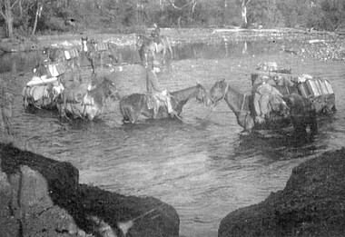
... Photo No. 9 Horses Crossing River - Packing in supplies for early workers on the Kiewa Hydro Scheme. There were no roads in the early days of the Scheme. Horses from the Kiewa Valley were used to transport goods prior to roads and vehicles being available...Kiewa Valley Historical Society Mount Beauty Information Centre 31 Bogong High Plains Rd Mt Beauty high-country Photo No. 9 Horses Crossing River - Packing in supplies for early workers on the Kiewa Hydro Scheme. There were no roads in the early days of the Scheme. Horses from the Kiewa Valley were used to transport goods prior to roads and vehicles being available Working Horses Horses from the Kiewa Valley 1. ...Photo No. 9 Horses Crossing River - Packing in supplies for early workers on the Kiewa Hydro Scheme. There were no roads in the early days of the Scheme. Horses from the Kiewa Valley were used to transport goods prior to roads and vehicles being available1. Horses crossing river - 2 copies 2. Pack horses 3. Rider with pack horse -x2 and See (KVHS 1396) 4. Cattle entering river 5. Horses on High Plains x2 6. color - Horses in River 7. Pack horses and carts 8. 4 Cattlemen with dog in foreground 9. Color - Horses crossing river 10.Horses and tents - Harry Trimble x2working horses, horses from the kiewa valley -
 Kiewa Valley Historical Society
Photos - Mills Family x 15
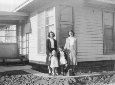
... river - show the fashion of the time and how families spent their recreational time. 2.& 3. The "70 Lakeside Ave" photos show the type of housing provided by the SECV and that the garden hadn't been created. 4. SEC marshalling yards, Mt Beauty c 1940s-50s. An historic photo of 1940s/50s buses used to transport ...Brian and Jill Mills lived with their children at Lakeside Ave. Mt Beauty. Brian was in the airforce.4 photos were taken during the construction of the Kiewa Hydro Electric Scheme. 1. The "Mills Kids" beside the river - show the fashion of the time and how families spent their recreational time. 2.& 3. The "70 Lakeside Ave" photos show the type of housing provided by the SECV and that the garden hadn't been created. 4. SEC marshalling yards, Mt Beauty c 1940s-50s. An historic photo of 1940s/50s buses used to transport KHES workers to their work sites, some of which were on the High Plains.15 large photos scanned in colour. 5 have labels written on the backOn the back "Brian Mills" (in airforce uniform); "Mills Kids / 78 L/side Ave"; "70 Lakeside Ave"; "70 L/side Ave" and "SEC Marshalling yards - Mt Beauty (and Donor's name and address.lakeside ave mt beauty, brian mills -
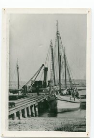
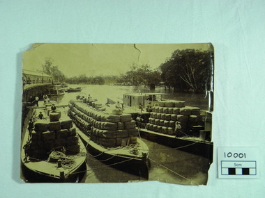 Port of Echuca
Photograph, P.S. Rodney with barges Horace & Nelson, c.1890
... P.S Rodney with barges Horace & Nelson laden with wool bales bought into the Port to be unloaded onto rail trucks to go to markets in Melbourne. c.1890 Paddlesteamers travelled the river systems to bring wool from out- lying properties into the Port of Echuca to be transported by rail to Melbourne. ...Port of Echuca 74 Murray Esplanade Echuca the-murray P.S Rodney with barges Horace & Nelson laden with wool bales bought into the Port to be unloaded onto rail trucks to go to markets in Melbourne. c.1890 Paddlesteamers travelled the river systems to bring wool from out- lying properties into the Port of Echuca to be transported by rail to Melbourne. ...P.S Rodney with barges Horace & Nelson laden with wool bales bought into the Port to be unloaded onto rail trucks to go to markets in Melbourne. c.1890 Paddlesteamers travelled the river systems to bring wool from out- lying properties into the Port of Echuca to be transported by rail to Melbourne. This was prior to road & rail transport in the 1800'sOne of thousands of photos taken depicting the transportation of wool from out- lying properties to the rail head at Port of Echuca using paddlesteamers. P.S.Rodney alongside barges Horace & Nelson, tied to historic Echuca Wharf, with Pride of the Murray paddlesteamer & barge in back ground all vessels loaded with wool bales and crew resting on these. Riverbank lined with red gums. Handwritten in pen on lower left back corner "Rodney with barges Horace & Nelson c. 1890"farming, economy, p s rodney, port of echuca, wool bales, wharf, barges, horrace, nelson, paddlesteamer rodney, echuca