Showing 31 items matching "road construction 1930s"
-
![Sustenance workers, Susso Drive [Yarra Boulevard], 1930s](/media/collectors/550653872162f11fb04854aa/items/58cf0689d0ce9809d870b7dd/item-media/58cf5a5cd0ce6633142774c9/item-fit-380x285.jpg?cb=6) Kew Historical Society Inc
Kew Historical Society IncPhotograph, Herald Sun, Sustenance workers, Susso Drive [Yarra Boulevard], 1930s
... ...road construction 1930s...Kew Historical Society Inc Kew Court House 188 High Street Kew melbourne The Yarra Boulevard was a major depression era public works project. yarra boulevard susso drive road construction 1930s the great depression (kew) Attached green postit: "In Herald Sun. ...The Yarra Boulevard was a major depression era public works project.Sustenance workers, Susso Drive [Yarra Boulevard], 1930s. Attached green postit: "In Herald Sun. Richmond section not Kew. Check with Richmond Historical Society.yarra boulevard, susso drive, road construction 1930s, the great depression (kew) -
![No.2 [Steam] Roller, Kew City Council](/media/collectors/550653872162f11fb04854aa/items/5c31f69121ea670d8459a8b6/item-media/5c31f77a21ea670d845a8063/item-fit-380x285.jpg?cb=6) Kew Historical Society Inc
Kew Historical Society IncPhotograph, No.2 [Steam] Roller, Kew City Council, c.1950
... Small black and white photograph of a steamroller used by the City of Kew in road construction from the 1930s to the 1950s....road construction - kew (vic) no.2 steamroller steamrollers - kew (vic) Reverse of photo: "KCC No 2 Roller 607S". Accompanying note: "20/3/84 Gift to the Society from Mr [?] who was K.C.C. [Kew City Council] driver of this "monster". Kew City Council No.2 Roller. Used in street construction 1950. Roller probably 1930 era." Small black and white photograph of a steamroller used by the City of Kew in road construction from the 1930s ...The Number 2 Steamroller was used in public road building in Kew.It replaced the first Council steamroller which was used between 1915 and 1932.Rare photograph of a Kew City Council piece of road making machinerySmall black and white photograph of a steamroller used by the City of Kew in road construction from the 1930s to the 1950s.Reverse of photo: "KCC No 2 Roller 607S". Accompanying note: "20/3/84 Gift to the Society from Mr [?] who was K.C.C. [Kew City Council] driver of this "monster". Kew City Council No.2 Roller. Used in street construction 1950. Roller probably 1930 era."road construction - kew (vic), no.2 steamroller, steamrollers - kew (vic) -
 Eltham District Historical Society Inc
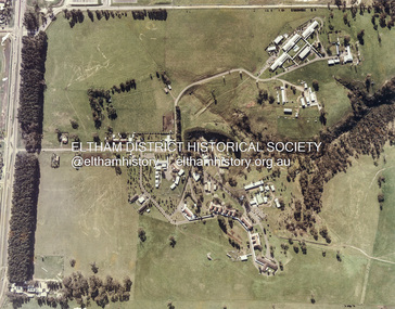
Photograph - Colour Print, Janefield, Bundoora, c.1982
... 1930s. Briar Hill School had one but Peter is not sure about any other local schools having a tree plantation. Mick informed Peter that it was his job to remove the 14 acres of pine tree roots, after the trees were cut down (due to old age and an infestation of sap sucking insects). For Mick, this was an impossible job, so he arranged a contract, to house all the soil removed from works associated with the construction of the Greensborough Bypass, which needed temporary storage as it was too valuable, and would be great for use in road construction. ...1930s. Briar Hill School had one but Peter is not sure about any other local schools having a tree plantation. Mick informed Peter that it was his job to remove the 14 acres of pine tree roots, after the trees were cut down (due to old age and an infestation of sap sucking insects). For Mick, this was an impossible job, so he arranged a contract, to house all the soil removed from works associated with the construction of the Greensborough Bypass, which needed temporary storage as it was too valuable, and would be great for use in road construction. ...The photo encompasses what is present-day University Hill shopping complex and the Janefield Wetlands. Plenty Road is just visible to the left of the photo. Janefield was an area 18 km north-east of central Melbourne that is now part of Bundoora. In 1842 a flour mill, powered by the Plenty River, was built at Janefield, although the locality was not known by that name at that time. It seems that the name Springfield was used in the late 1840s, after a Springfield homestead, and this was changed to Janefield possibly upon the death of Jane Brock in 1847. She was the wife of James Brock, a local landowner and son of the purchaser of the flour mill. This photo is not strictly within the area of interest for EDHS but overlaps do occur at times with other Society’s interests through families and other associated connections. Eltham District Historical Society member (and Greensborough Historical Society member), Peter Van Eeken was undertaking research into this photo and approached the Local History Librarian at Yarra Plenty Regional Library to enquire about digitising the large print copy to facilitate research. Approaches were made to EDHS who had suitable facilities and were willing to accommodate and all parties agreed to add the image as part of their respective collections in partnership. Michael Lanigan, started work as a message boy at Mont Park when he left school at age 14. He worked his way up the system to become farm manager at Mont Park and Janefield Special School. He was one of the last people to drive a herd of cattle (in 1964) between the two locations along Plenty Road. He retired when the school closed around 1993. Mick pointed out the location of three remnant farm houses of the 1800s. The Brock House being the main one. Peter has been unable to find any photos of the Brock House, which what built in the late 1850s, severely burnt in the 1930s and demolished in the mid 1960s. The tree plantation along Plenty Road was established in 1930 and cut down in the mid 1980s. The Victorian Government established tree plantations at about 350 schools in the early 1930s. Briar Hill School had one but Peter is not sure about any other local schools having a tree plantation. Mick informed Peter that it was his job to remove the 14 acres of pine tree roots, after the trees were cut down (due to old age and an infestation of sap sucking insects). For Mick, this was an impossible job, so he arranged a contract, to house all the soil removed from works associated with the construction of the Greensborough Bypass, which needed temporary storage as it was too valuable, and would be great for use in road construction. The contract to store the soil was important to Mick, as the contract stipulated that when the soil was eventually removed, the tree roots had to be removed too. Which got rid of Mick's headache. Apparently, the huge mound of soil that covered the roots in the late 1980s could be seen from Briar Hill. Based on this, the photo is most likely to have been taken 1982 or 1983. The key to a final date is working out when the Board of Works Office opened but so far no information has come to light. (It was purchased by La Trobe University in 1991). The Office existed, or is hinted at, in the photo at the extreme north of the photo, opposite McKimmies Road, on the eastern side of Plenty Road. Photo on loan from Michael Lanigan via Peter Van Eeken. He cannot recall why it was taken. brock family, janefield, janefield drive, janefield wetlands, plenty road, university hill -
 Glen Eira Historical Society
Book - Hillcrest Estate Draft Heritage Guidelines July 2000
... Road numbers 27 and 28. The Heritage Area has been assessed as noteworthy as 'the first housing estate developed by the AV Jennings Construction Co., later known as Jennings Group Limited.' Developed during the Depression years of the early 1930s...Road numbers 27 and 28. The Heritage Area has been assessed as noteworthy as 'the first housing estate developed by the AV Jennings Construction Co., later known as Jennings Group Limited.' Developed during the Depression years of the early 1930s ...2 items about Hillcrest Estate and heritage: 1/A 20 page report giving draft heritage guidelines by the City of Glen Eira for properties within the Hillcrest Estate Heritage Area of Caulfield South, including Hillcrest Avenue numbers 1 and 3-12 and Marara Road numbers 27 and 28. The Heritage Area has been assessed as noteworthy as 'the first housing estate developed by the AV Jennings Construction Co., later known as Jennings Group Limited.' Developed during the Depression years of the early 1930s, it is considered an 'unusually intact example of an interwar garden estate' and is also considered noteworthy for its aesthetic values. The Report describes typical features for two house forms typical of the area: the single-storey villa with decorative porch and the single storey villa with decorative verandah. It gives guidelines on the types of changes which can be made to houses within the Heritage Area. Included are photographs of typical houses and design features, maps, and diagrams showing acceptable zones for additions, amongst other Sections (eg. Key design checklist). 2/A three page photocopy taken from Andrew Ward's Heritage Study for The Hillcrest Estate Historic Area.hillcrest estate, glen eira heritage management plan, glen eira planning scheme, glen eira city council, hillcrest estate heritage area, hillcrest avenue, merri street, marara road, eumerella street, av jennings construction co, jennings group limited, caulfield south, jennings albert, brick houses, architectural styles, architectural features, housing estates, garden estate, heritage studies, glen eira city council, city of glen eira, draft heritage guidelines july 2000, glen huntly, vines william, gurney edward, eumeralla street, 'karkill', house names, cropmpton court, booran road, estate agents -
 Greensborough Historical Society
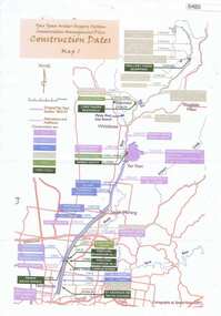
Maps, Yan Yean Water Supply System Conservation Management Plan: Construction dates Map 1, 2007_
... Greensborough Historical Society 34A Glenauburn Road Lower Plenty Lower Plenty melbourne Plan of Yan Yean Water Supply System, showing natural and constructed features from 1850s to 1930s from Silver Creek Weirs to Eastern Freeway. water supply yan yean reservoir plenty river Printed in colour one side. 3 copies Yan Yean Water Supply System Conservation Management Plan: Construction dates Map 1 Maps Spatial Vision ...Plan of Yan Yean Water Supply System, showing natural and constructed features from 1850s to 1930s from Silver Creek Weirs to Eastern Freeway.Printed in colour one side. 3 copieswater supply, yan yean reservoir, plenty river -
 Eltham District Historical Society Inc
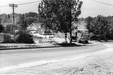
Photograph, Looking southeast from Main Road at intersection with Brougham Street, c. September 1966, 1966c
... 1930s. The property was known as Cooinda. The Bradbury family also owned the houses adjacent to Napoleon Street. Succeeding Dr Bradbury was Dr R.B. Loosli, resident from 1947 to 1961. The house was later developed into a series of restaurants, Marcella's in the 1980s/1990s, Gennaro's Pizza Restaurant 2010s, Franco Pizza, presently being Franco and Co. Brougham Steet Franco and Co local history centre Main Road Restaurants Road construction ...View looking across the front grounds of the former Police Station towards the weatherboard building on the opposite corner of Brougham Street which was once used as a Doctor's surgery by Dr R. Bradbury in the 1930s. The property was known as Cooinda. The Bradbury family also owned the houses adjacent to Napoleon Street. Succeeding Dr Bradbury was Dr R.B. Loosli, resident from 1947 to 1961. The house was later developed into a series of restaurants, Marcella's in the 1980s/1990s, Gennaro's Pizza Restaurant 2010s, Franco Pizza, presently being Franco and Co.Black and white photographic printOriginally located in a Filmpro King Size Prints processing envelope $3.01 Shire of Eltham 9/9/66 and noted as Calrossie Ave area and crossed out Eltham-Yarra Glen Road, Bridge Street to Elsa Court existing conditions mid 1967brougham steet, franco and co, local history centre, main road, restaurants, road construction, streets, cooinda -
 Eltham District Historical Society Inc
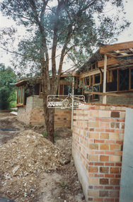
Photograph - Colour Print, Nathan Islip, Eltham Library under construction, c.1993
... construction project. Eltham Library Service 1930s - 1994 Originally collated by Harry Gilham, President, Eltham District Historical Society Inc (1993-2009) (edited 2022) In the Eltham township area, in the early 1930s, library books for adults were available from E J Andrew's newsagency in Main Road. ...construction project. Eltham Library Service 1930s - 1994 Originally collated by Harry Gilham, President, Eltham District Historical Society Inc (1993-2009) (edited 2022) In the Eltham township area, in the early 1930s, library books for adults were available from E J Andrew's newsagency in Main Road. ...Photo taken by Nathan Islip who at the time was studying Architecture at the University of Melbourne. During his experience year he worked as a builder's labourer on the new Eltham Library construction project. Eltham Library Service 1930s - 1994 Originally collated by Harry Gilham, President, Eltham District Historical Society Inc (1993-2009) (edited 2022) In the Eltham township area, in the early 1930s, library books for adults were available from E J Andrew's newsagency in Main Road. In the newsagency cum haberdashery, some shelves were set aside for a lending library of adults' books. In 1935, Mr & Mrs JC Rains purchased the newsagency and continued the lending service until the late 1940s. At this time the business was extended from haberdashery to sell ladies' and men's clothing. The library section was discontinued. In the 1930s a mobile book library was also run by a Mr Foster of Bible Street, Eltham. In the 1950s adult books were available from racks in the foyer of the Eltham Shire Offices which was then located beside the Eltham Hall on the comer of Arthur Street and Main Road. In the early 1950s a referendum of ratepayers was called to seek public opinion on the issue of raising money for a public library for which the rates would have to be increased - the motion was defeated. On 11 November 1965 Eltham Shire Council, in conjunction with the City of Heidelberg and the Shire of Diamond Valley, met to form the Heidelberg Regional Library Service. Eltham was represented by Councillors Charis Pelling and John Lewis. The first library service for the Shire of Eltham from this group came in the shape of a bookmobile van which had, amongst others, a central stopover near the Shillinglaw trees outside the newly opened Shire offices at 895 Main Road, the original site of Shillinglaw Cottage and the former Shillinglaw farm. Present-day Wingrove Park was another stopover and the many recorded requests for this service can be read as denoting the areas of population or gathering points at that period throughout the Shire. 1968 saw the Shire convert the ‘Brinkkotter’ house in Dudley Street to house both adult and children's books. This library was originally staffed from the City of Heidelberg Library and records of committee meetings range from borrowing Heidelberg's old library shelving to trying to increase the Government's subsidy to a dollar for dollar basis. Book loans in the period 1966-67 totalled 30,400 and the following year ran to 52,113. With 2 books plus 1 paperback the limit per person, it was overcrowded and unable to house the range of other services which had become common library stock. Planning to extend the Shire Offices by the addition of the south wing was an opportunity to re-house the Shire's Library. The opening of the library in the extension was carried out on 17th August 1971 by the Hon R J Hamer ED, MP, Chief Secretary of Victoria. Cr Geoffrey Dreverman officiated as the Shire President. The Heidelberg Regional Library Service continued until September 1985 when it disbanded. On 21 November 1985 the Yarra Plenty Regional Library Service was established. At that time Eltham was represented by Councillors Mary Grant and Robert Manuell. By 1987, over-crowding of the Eltham Library and an inability to house the range of other services yet again rose to prominence. At a Council meeting held on 1 June 1987, the Councillors supported a resolution which threatened to close the library on 30 September 1987. Council's frustration arose from yet another re-run of the annual State Government versus Council Library funding and records show first arose in Eltham Council in 1967 with the Government of 1he day. After prolonged public anger and petitions the motion to close the library was rescinded in August 1987. Council, considering the community's concern, set up a ‘Library Review Working Party’ which a year later became the Library Occasional Committee with direct access to Council. This Committee investigated the workings of the 386 square metre library and found inadequate space for storage and display, lack of equipment, out-of-date furniture together with an increasing patronage which resulted in queues of borrowers becoming longer no matter when the library was open. Community consultation took the form of 1,000 questionnaires sent to users and non-users along with noticeboard reminders of what was planned. Council developed a strategy to set aside capital funds from 1988 on an annual basis so that preliminary planning and consultative expenses could be met, and construction could be completed early 1997. The Committee visited metropolitan libraries which were catering for a similar population as was projected for Eltham. Australia-wide Federal Government funding grants under the Local Capital Works Program became available from October 1992 for community projects endorsed by local Councils. The Eltham Council submitted a proposal, based on library findings and requirements accumulated by the Library Occasional Committee, to the Federal Grants Committee to build a new Eltham Library. The Federal Grants Committee supported the funding request allowing commencement of the library project three years earlier than planned. With finance finalised, the Council set up its Eltham Library Re-development Special Committee which was given the task of overseeing what could be the last major expansion of the Shire's Library Service as Eltham's population nears its projected maximum. The new library was designed by Gregory Burgess and Peter Ryan of Gregory Burgess Pty Ltd. Construction of the library commenced in 1993 and was officially opened May 22nd, 1994. The library building was designed to reflect its parkland setting. External features include: the roof which includes interesting aspects when viewed from Main Road; verandahs which provide ramp access and give a sheltered entrance to the building; walls which feature locally made mudbricks, conventional bricks and copper panels; and space for an outdoor courtyard/reading area which will be developed later. Internally there are several features. The building includes a foyer with a fireplace suitable for displays including artwork, a community multi-purpose room suitable for meetings or functions and an outdoor cafeteria. The ceilings are lined with Victorian Ash. The shapes for the ceiling give a free-flowing form to the building. Brush Box has been used for the circulation and information desks. The tree trunk columns are Grey lronbark from New South Wales. Arches and various-shaped windows add interest to the internal structure. The carpet design reflects the Eltham environment and compliments the natural colours and timbers used in the building. Tiles by artist Felix Bosari feature in the building and additional art by local artists added externally and internally to the building. Since 1994 the library has undergone a major extension to cater for children’s services and others. See also EDHS_02111 construction, eltham library -
 Eltham District Historical Society Inc
Photograph - Colour Print, Nathan Islip, Eltham Library under construction, c.1994
... construction project. Eltham Library Service 1930s - 1994 Originally collated by Harry Gilham, President, Eltham District Historical Society Inc (1993-2009) (edited 2022) In the Eltham township area, in the early 1930s, library books for adults were available from E J Andrew's newsagency in Main Road. ...construction project. Eltham Library Service 1930s - 1994 Originally collated by Harry Gilham, President, Eltham District Historical Society Inc (1993-2009) (edited 2022) In the Eltham township area, in the early 1930s, library books for adults were available from E J Andrew's newsagency in Main Road. ...Photo taken by Nathan Islip who at the time was studying Architecture at the University of Melbourne. During his experience year he worked as a builder's labourer on the new Eltham Library construction project. Eltham Library Service 1930s - 1994 Originally collated by Harry Gilham, President, Eltham District Historical Society Inc (1993-2009) (edited 2022) In the Eltham township area, in the early 1930s, library books for adults were available from E J Andrew's newsagency in Main Road. In the newsagency cum haberdashery, some shelves were set aside for a lending library of adults' books. In 1935, Mr & Mrs JC Rains purchased the newsagency and continued the lending service until the late 1940s. At this time the business was extended from haberdashery to sell ladies' and men's clothing. The library section was discontinued. In the 1930s a mobile book library was also run by a Mr Foster of Bible Street, Eltham. In the 1950s adult books were available from racks in the foyer of the Eltham Shire Offices which was then located beside the Eltham Hall on the comer of Arthur Street and Main Road. In the early 1950s a referendum of ratepayers was called to seek public opinion on the issue of raising money for a public library for which the rates would have to be increased - the motion was defeated. On 11 November 1965 Eltham Shire Council, in conjunction with the City of Heidelberg and the Shire of Diamond Valley, met to form the Heidelberg Regional Library Service. Eltham was represented by Councillors Charis Pelling and John Lewis. The first library service for the Shire of Eltham from this group came in the shape of a bookmobile van which had, amongst others, a central stopover near the Shillinglaw trees outside the newly opened Shire offices at 895 Main Road, the original site of Shillinglaw Cottage and the former Shillinglaw farm. Present-day Wingrove Park was another stopover and the many recorded requests for this service can be read as denoting the areas of population or gathering points at that period throughout the Shire. 1968 saw the Shire convert the ‘Brinkkotter’ house in Dudley Street to house both adult and children's books. This library was originally staffed from the City of Heidelberg Library and records of committee meetings range from borrowing Heidelberg's old library shelving to trying to increase the Government's subsidy to a dollar for dollar basis. Book loans in the period 1966-67 totalled 30,400 and the following year ran to 52,113. With 2 books plus 1 paperback the limit per person, it was overcrowded and unable to house the range of other services which had become common library stock. Planning to extend the Shire Offices by the addition of the south wing was an opportunity to re-house the Shire's Library. The opening of the library in the extension was carried out on 17th August 1971 by the Hon R J Hamer ED, MP, Chief Secretary of Victoria. Cr Geoffrey Dreverman officiated as the Shire President. The Heidelberg Regional Library Service continued until September 1985 when it disbanded. On 21 November 1985 the Yarra Plenty Regional Library Service was established. At that time Eltham was represented by Councillors Mary Grant and Robert Manuell. By 1987, over-crowding of the Eltham Library and an inability to house the range of other services yet again rose to prominence. At a Council meeting held on 1 June 1987, the Councillors supported a resolution which threatened to close the library on 30 September 1987. Council's frustration arose from yet another re-run of the annual State Government versus Council Library funding and records show first arose in Eltham Council in 1967 with the Government of 1he day. After prolonged public anger and petitions the motion to close the library was rescinded in August 1987. Council, considering the community's concern, set up a ‘Library Review Working Party’ which a year later became the Library Occasional Committee with direct access to Council. This Committee investigated the workings of the 386 square metre library and found inadequate space for storage and display, lack of equipment, out-of-date furniture together with an increasing patronage which resulted in queues of borrowers becoming longer no matter when the library was open. Community consultation took the form of 1,000 questionnaires sent to users and non-users along with noticeboard reminders of what was planned. Council developed a strategy to set aside capital funds from 1988 on an annual basis so that preliminary planning and consultative expenses could be met, and construction could be completed early 1997. The Committee visited metropolitan libraries which were catering for a similar population as was projected for Eltham. Australia-wide Federal Government funding grants under the Local Capital Works Program became available from October 1992 for community projects endorsed by local Councils. The Eltham Council submitted a proposal, based on library findings and requirements accumulated by the Library Occasional Committee, to the Federal Grants Committee to build a new Eltham Library. The Federal Grants Committee supported the funding request allowing commencement of the library project three years earlier than planned. With finance finalised, the Council set up its Eltham Library Re-development Special Committee which was given the task of overseeing what could be the last major expansion of the Shire's Library Service as Eltham's population nears its projected maximum. The new library was designed by Gregory Burgess and Peter Ryan of Gregory Burgess Pty Ltd. Construction of the library commenced in 1993 and was officially opened May 22nd, 1994. The library building was designed to reflect its parkland setting. External features include: the roof which includes interesting aspects when viewed from Main Road; verandahs which provide ramp access and give a sheltered entrance to the building; walls which feature locally made mudbricks, conventional bricks and copper panels; and space for an outdoor courtyard/reading area which will be developed later. Internally there are several features. The building includes a foyer with a fireplace suitable for displays including artwork, a community multi-purpose room suitable for meetings or functions and an outdoor cafeteria. The ceilings are lined with Victorian Ash. The shapes for the ceiling give a free-flowing form to the building. Brush Box has been used for the circulation and information desks. The tree trunk columns are Grey lronbark from New South Wales. Arches and various-shaped windows add interest to the internal structure. The carpet design reflects the Eltham environment and compliments the natural colours and timbers used in the building. Tiles by artist Felix Bosari feature in the building and additional art by local artists added externally and internally to the building. Since 1994 the library has undergone a major extension to cater for children’s services and others. See also EDHS_02111 construction, eltham library -
 Orbost & District Historical Society
black and white photograph, mid 1930s
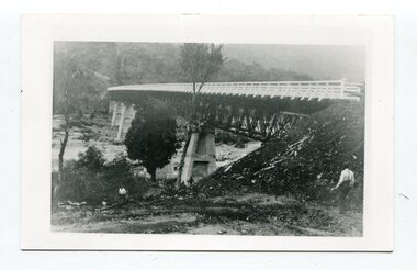
... road approaches. "McKillops Bridge was Heritage listed due to its social and technological significance – the steel trusses' arc-welded construction technique was a pretty big deal in the 1930s. ...road approaches. "McKillops Bridge was Heritage listed due to its social and technological significance – the steel trusses' arc-welded construction technique was a pretty big deal in the 1930s. ...This is a photograph of McKillop's Bridge probably taken just after its rebuilding. The current McKillop’s Bridge was built by the Country Roads Board in two stages between 1931-36, during which its height was raised after the original bridge superstructure was washed away in record floods of January 1934, prior to its original official opening. In its reconstructed form the original concrete abutments were turned into additional piers and the welded-steel trusses were cantilevered back over them to meet the new higher road approaches. "McKillops Bridge was Heritage listed due to its social and technological significance – the steel trusses' arc-welded construction technique was a pretty big deal in the 1930s. It was once an important route for cattlemen, who used the ford across the Snowy in the years preceding the bridge's existence"This is a pictorial record of McKillop's Bridge just after its construction.A black / white photograph of a wooden bridge across a river. At the bottom right is a man with his back to the camera. He is looking at flood debris on the bank. At the bottom left are two men near a pylon.on back - McKillops Bridgebridge-mckillop's snowy-river-bridge -
 Orbost & District Historical Society
programs, 1961
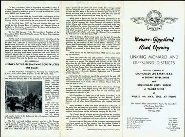
... construction of a road to connect Monaro and Gippsland, via Inglebyra and Black Mountain. The only track was for stock, made by pioneers many years ago, and it was very circuitous. It was stated at a meeting at Dalgety that the road would open up large areas for settlement for grazing, and for timber suitable for bridgé building. The road would assist stock deal ing between Monaro and Gippsland. It would also considerably shorten the distance from Victoria for tourists visiting Canberra and Kosciusko. A committee was formed to put the proposal before the Dalgety Shire Council in the 1930s...construction of a road to connect Monaro and Gippsland, via Inglebyra and Black Mountain. The only track was for stock, made by pioneers many years ago, and it was very circuitous. It was stated at a meeting at Dalgety that the road would open up large areas for settlement for grazing, and for timber suitable for bridgé building. The road would assist stock deal ing between Monaro and Gippsland. It would also considerably shorten the distance from Victoria for tourists visiting Canberra and Kosciusko. A committee was formed to put the proposal before the Dalgety Shire Council in the 1930s ...The Snowy River Shire was a local government area in the Australian Alps region of New South Wales, Australia from 1939 until May 2016. It was named after the Snowy River that runs through it. Prior to 1936, it had been named as Dalgety Shire since establishment in 1906. This opening of the Monaro - Gippsland Road took place on 4th May 1961. There had long been a movement in Monaro for the construction of a road to connect Monaro and Gippsland, via Inglebyra and Black Mountain. The only track was for stock, made by pioneers many years ago, and it was very circuitous. It was stated at a meeting at Dalgety that the road would open up large areas for settlement for grazing, and for timber suitable for bridgé building. The road would assist stock deal ing between Monaro and Gippsland. It would also considerably shorten the distance from Victoria for tourists visiting Canberra and Kosciusko. A committee was formed to put the proposal before the Dalgety Shire Council in the 1930s.This item is a useful research tool.Four copies of a road opening program. It has black print on white. There are black / white photographs, historical details and details of the official opening.program monaro-road snowy-river-shire -
 Flagstaff Hill Maritime Museum and Village
Craft - Ship Model, Peter Payne, Early 1930s to 1960s
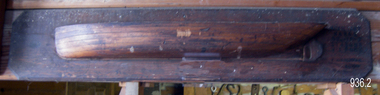
... road Half-hull ship models were an important step in the process of building a vessel. Shipwrights or designers would construct a half-hull scale model of a ship before the vessel was built. They used it to ensure that the dimensions would work together and that the ship look balanced. They would often mount the half hull onto a board in their workshop. The half-hull ship models were also used to show prospective buyers how the design would work and look. Given the plywood construction of the model, it is believed to have been made around the 1930s ...Half-hull ship models were an important step in the process of building a vessel. Shipwrights or designers would construct a half-hull scale model of a ship before the vessel was built. They used it to ensure that the dimensions would work together and that the ship look balanced. They would often mount the half hull onto a board in their workshop. The half-hull ship models were also used to show prospective buyers how the design would work and look. Given the plywood construction of the model, it is believed to have been made around the 1930s as plywood construction had started in earnest in Queensland around this time and soon became the centre of the industry because of Queensland's attractive rain forest woods used which also included red cedar, silver ash, black bean, Queensland maple and silky oak. It is also believed the model was a design for a clinker-built barge to be built by Peter Payne who operated a boat building works on the Mordialloc Creek, Victoria going out of business in 1973. Records show Peter Paynes' first craft launched in 1962 and the last in 1973 from Mordialloc Creek works. However, he was one of the most prolific builders from the 1930s and produced many more vessels than the records currently show. There is at this point no further record of the subject model or whether a full version was ever built and for whom is not known at this time.A model that demonstrates the boat-building process is believed to have been made by Peter Payne or someone who worked in his yard. P Payne was a very well-known boating personality, vessel captain and boat builder throughout most of the 20th century. Model barge half hull on wooden of plywood laminated construction. Marked "AUXILIARY BARGE 80'x16'x6' 315 TONS 4" - 1 FOOT" "P and H PAYNE?" "22/E/26" flagstaff hill, warrnambool, flagstaff-hill, flagstaff-hill-maritime-museum, maritime-museum, shipwreck-coast, flagstaff-hill-maritime-village, ship model half hull, ship half model, shipbuilding, shipwright, ship design, peter payne, boat builder victoria, clinker design, barge -
 Sunshine and District Historical Society Incorporated
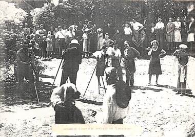
Photograph - Sunshine Cinematic Society C1930 Photograph
... Brimbank Library, 301 Hampshire Road, Sunshine 3020. melbourne John “Jack” Horace Jackson, the founder of the Sunshine Cinematic Society, was a long‑time Sunshine resident, a Harvester Works employee and owner of his own engineering company, and one of the suburb’s earliest and most important amateur filmmakers. He had his home private picture theatre called The Gladina at his Withers Street house and was the creator of numerous films showing Sunshine landmarks, construction works, and community life. John Jackson was an avid film and radio enthusiast who documented everyday life in Sunshine from the 1930s ...John “Jack” Horace Jackson, the founder of the Sunshine Cinematic Society, was a long‑time Sunshine resident, a Harvester Works employee and owner of his own engineering company, and one of the suburb’s earliest and most important amateur filmmakers. He had his home private picture theatre called The Gladina at his Withers Street house and was the creator of numerous films showing Sunshine landmarks, construction works, and community life.John Jackson was an avid film and radio enthusiast who documented everyday life in Sunshine from the 1930s to the 1960s. 5705 - Sunshine Cinematic Society C1930's Photograph .jpgsunshine cinematic society, john "jack" horace jackson -
 Surrey Hills Historical Society Collection
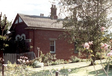
Photograph, Tavistock at 192 Union Road, 1978
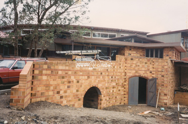
... 1930s to 1960s it was home to Miss Marjorie Vahland, a locally well-known nursing sister. See History Walks No 5, p 11 and p32 Surrey Hills In Celebration of its Centennial 1883-1983 tavistock milverton girls school victorian style houses joyce walker miss marjorie vahland nurses Colour photo of the north side of Tavistock at 192 Union Road, Surrey Hills revealed when this side of the property was partially without a fence; taken while re-fencing. The house is Victorian in style, of red brick construction ...The date is approximate. Tavistock was built c1890. The side windows on the front room are a later addition in a different style from the original windows. In 1897 it was the home of the Walker family; Joyce Walker later became matron of Mosgiel Hospital. In 1902 it became the first site of Milverton Girls School. From 1930s to 1960s it was home to Miss Marjorie Vahland, a locally well-known nursing sister. See History Walks No 5, p 11 and p32 Surrey Hills In Celebration of its Centennial 1883-1983Colour photo of the north side of Tavistock at 192 Union Road, Surrey Hills revealed when this side of the property was partially without a fence; taken while re-fencing. The house is Victorian in style, of red brick construction with a patterned slate tile roof and decorative chimneys.tavistock, milverton girls school, victorian style, houses, joyce walker, miss marjorie vahland, nurses -
 Surrey Hills Historical Society Collection
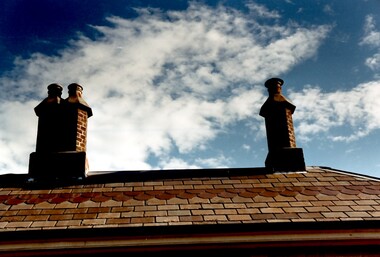
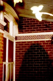
Photograph, Chimneys of 'Tavistock' at 192 Union Road, Surrey Hills, 1978
... From 1930s to 1960s it was home to Miss Marjorie Vahland, a locally well-known nursing sister. tavistock milverton girls school victorian style houses matron joyce walker miss marjorie vahland Colour photo of the roof and chimneys of 'Tavistock' at 192 Union Road, Surrey Hills. The house is Victorian in style, of red brick construction ...See History Walks No 5, p 11 and p32 Surrey Hills In Celebration of its Centennial 1883-1983 The date is approximate. Tavistock was built c1890. In 1897 it was the home of the Walker family; Joyce Walker later became matron of Mosgiel Hospital. In 1902 it became the first site of Milverton Girls School. From 1930s to 1960s it was home to Miss Marjorie Vahland, a locally well-known nursing sister.Colour photo of the roof and chimneys of 'Tavistock' at 192 Union Road, Surrey Hills. The house is Victorian in style, of red brick construction with a patterned slate tile roof and decorative chimneys.tavistock, milverton girls school, victorian style, houses, matron joyce walker, miss marjorie vahland -
 Surrey Hills Historical Society Collection
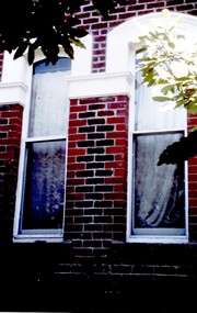
Photograph, Tavistock at 192 Union Road, 1978
... From 1930s to 1960s it was home to Miss Marjorie Vahland, a locally well-known nursing sister. tavistock milverton girls school victorian style houses joyce walker marjorie vahland Colour photo of the front of Tavistock at 192 Union Road, Surrey Hills before restoration during 1978-1982. The house is Victorian in style, of red brick construction ...See History Walks No 5, p 11 and p32 Surrey Hills In Celebration of its Centennial 1883-1983. Tavistock was built c1890. In 1897 it was the home of the Walker family; Joyce Walker later became matron of Mosgiel Hospital. In 1902 it became the first site of Milverton Girls School. From 1930s to 1960s it was home to Miss Marjorie Vahland, a locally well-known nursing sister.Colour photo of the front of Tavistock at 192 Union Road, Surrey Hills before restoration during 1978-1982. The house is Victorian in style, of red brick construction with a patterned slate tile roof and decorative chimneys. This photo of the windows at the front of the house is prior to stripping of the white paint from the decorative tiles.tavistock, milverton girls school, victorian style, houses, joyce walker, marjorie vahland -
 Surrey Hills Historical Society Collection
Photograph, Tavistock at 192 Union Road, 1978
... 1930s to 1960s it was home to Miss Marjorie Vahland, a locally well-known nursing sister. See History Walks No 5, p 11 and p32 Surrey Hills In Celebration of its Centennial 1883-1983 tavistock milverton girls school victorian style houses joyce walker marjorie vahland 1890-1900 Colour photo of the front of Tavistock at 192 Union Road, Surrey Hills before restoration during 1978-1982. The house is Victorian in style, of red brick construction ...The date is approximate. Tavistock was built c1890. In 1897 it was the home of the Walker family; Joyce Walker later became matron of Mosgiel Hospital. In 1902 it became the first site of Milverton Girls School. From 1930s to 1960s it was home to Miss Marjorie Vahland, a locally well-known nursing sister. See History Walks No 5, p 11 and p32 Surrey Hills In Celebration of its Centennial 1883-1983Colour photo of the front of Tavistock at 192 Union Road, Surrey Hills before restoration during 1978-1982. The house is Victorian in style, of red brick construction with a patterned slate tile roof and decorative chimneys. This photo of the entrance at the front of the house shows the decorative tiles which were later found around the windows at the front as well.tavistock, milverton girls school, victorian style, houses, joyce walker, marjorie vahland, 1890-1900 -
 Surrey Hills Historical Society Collection
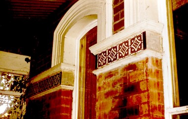
Photograph, Tavistock at 192 Union Road, 1978
... 1930s to 1960s it was home to Miss Marjorie Vahland, a locally well-known nursing sister. See History Walks No 5, p 11 and p32 Surrey Hills In Celebration of its Centennial 1883-1983| tavistock milverton girls school victorian style houses joyce walker marjorie vahland Colour photo of detail under the front verandah of Tavistock at 192 Union Road, Surrey Hills during restoration during 1978-1982. The house is Victorian in style, of red brick construction ...The date is approximate. Tavistock was built c1890. In 1897 it was the home of the Walker family; Joyce Walker later became matron of Mosgiel Hospital. In 1902 it became the first site of Milverton Girls School. From 1930s to 1960s it was home to Miss Marjorie Vahland, a locally well-known nursing sister. See History Walks No 5, p 11 and p32 Surrey Hills In Celebration of its Centennial 1883-1983|Colour photo of detail under the front verandah of Tavistock at 192 Union Road, Surrey Hills during restoration during 1978-1982. The house is Victorian in style, of red brick construction with a patterned slate tile roof and decorative chimneys. This photo shows the decorative tiles around the window under the front verandah. These had been stripped of white paint. The photo is taken prior to repainting the masonry. Similar decorative tiles were later also found around the windows at the front.tavistock, milverton girls school, victorian style, houses, joyce walker, marjorie vahland -
 Surrey Hills Historical Society Collection
Photograph, Tavistock at 192 Union Road, 1978
... 1930s to 1960s it was home to Miss Marjorie Vahland, a locally well-known nursing sister. See History Walks No 5, p 11 and p32 Surrey Hills In Celebration of its Centennial 1883-1983. tavistock milverton girls school victorian style houses 1890-1900 joyce walker marjorie vahland Union Road Colour photo of detail under the front verandah of Tavistock at 192 Union Road, Surrey Hills during restoration during 1978-1982. The house is Victorian in style, of red brick construction ...The date is approximate. Tavistock was built c1890. In 1897 it was the home of the Walker family; Joyce Walker later became matron of Mosgiel Hospital. In 1902 it became the first site of Milverton Girls School. From 1930s to 1960s it was home to Miss Marjorie Vahland, a locally well-known nursing sister. See History Walks No 5, p 11 and p32 Surrey Hills In Celebration of its Centennial 1883-1983.Colour photo of detail under the front verandah of Tavistock at 192 Union Road, Surrey Hills during restoration during 1978-1982. The house is Victorian in style, of red brick construction with a patterned slate tile roof and decorative chimneys. This photo shows the decorative tiles around the window under the front verandah. These had been stripped of white paint. The photo is taken prior to repainting the masonry. Similar decorative tiles were later also found around the windows at the front. The photo also shows the house name plate.tavistock, milverton girls school, victorian style, houses, 1890-1900, joyce walker, marjorie vahland, union road -
 Surrey Hills Historical Society Collection
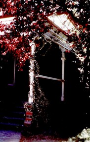
Photograph, Tavistock at 192 Union Road, 1978
... From 1930s to 1960s it was home to Miss Marjorie Vahland, a locally well-known nursing sister. tavistock milverton girls school victorian style houses union road 1890-1900 joyce walker marjorie vahland Colour photo of the front verandah of Tavistock at 192 Union Road, Surrey Hills taken from the front garden during the period of restoration during 1978-1982. The house is Victorian in style, of red brick construction ...See History Walks No 5, p 11 and p32 Surrey Hills In Celebration of its Centennial 1883-1983|The date is approximate. Tavistock was built c1890. In 1897 it was the home of the Walker family; Joyce Walker later became matron of Mosgiel Hospital. In 1902 it became the first site of Milverton Girls School. From 1930s to 1960s it was home to Miss Marjorie Vahland, a locally well-known nursing sister.Colour photo of the front verandah of Tavistock at 192 Union Road, Surrey Hills taken from the front garden during the period of restoration during 1978-1982. The house is Victorian in style, of red brick construction with a patterned slate tile roof and decorative chimneys.tavistock, milverton girls school, victorian style, houses, union road, 1890-1900, joyce walker, marjorie vahland -
 Surrey Hills Historical Society Collection
Photograph, Tavistock at 192 Union Road, 1978
... 1930s to 1960s it was home to Miss Marjorie Vahland, a locally well-known nursing sister. See History Walks No 5, p 11 and p32 Surrey Hills In Celebration of its Centennial 1883-1983| tavistock milverton girls school victorian style houses 1890-1900 Union Road joyce walker marjorie vahland Colour photo of the front of Tavistock at 192 Union Road, Surrey Hills taken from the front garden during the period of restoration during 1978-1982. The house is Victorian in style, of red brick construction ...The date is approximate. Tavistock was built c1890. In 1897 it was the home of the Walker family; Joyce Walker later became matron of Mosgiel Hospital. In 1902 it became the first site of Milverton Girls School. From 1930s to 1960s it was home to Miss Marjorie Vahland, a locally well-known nursing sister. See History Walks No 5, p 11 and p32 Surrey Hills In Celebration of its Centennial 1883-1983|Colour photo of the front of Tavistock at 192 Union Road, Surrey Hills taken from the front garden during the period of restoration during 1978-1982. The house is Victorian in style, of red brick construction with a patterned slate tile roof and decorative chimneys.tavistock, milverton girls school, victorian style, houses, 1890-1900, union road, joyce walker, marjorie vahland -
 Surrey Hills Historical Society Collection
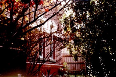
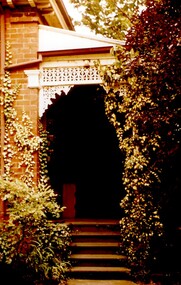
Photograph, Tavistock at 192 Union Road, 1978
... 1930s to 1960s it was home to Miss Marjorie Vahland, a locally well-known nursing sister. See History Walks No 5, p 11 and p32 Surrey Hills In Celebration of its Centennial 1883-1983. tavistock milverton girls school victorian style houses 1890-1900 Union road joyce walker marjorie vahland Colour photo of the front steps at Tavistock at 192 Union Road, Surrey Hills taken from the front garden during the period of restoration during 1978-1982. The house is Victorian in style, of red brick construction ...The date is approximate. Tavistock was built c1890. In 1897 it was the home of the Walker family; Joyce Walker later became matron of Mosgiel Hospital. In 1902 it became the first site of Milverton Girls School. From 1930s to 1960s it was home to Miss Marjorie Vahland, a locally well-known nursing sister. See History Walks No 5, p 11 and p32 Surrey Hills In Celebration of its Centennial 1883-1983.Colour photo of the front steps at Tavistock at 192 Union Road, Surrey Hills taken from the front garden during the period of restoration during 1978-1982. The house is Victorian in style, of red brick construction with a patterned slate tile roof and decorative chimneys. The photo shows the wrought iron detail on the verandah.tavistock, milverton girls school, victorian style, houses, 1890-1900, union road, joyce walker, marjorie vahland -
 Surrey Hills Historical Society Collection
Photograph, Tavistock at 192 Union Road, 1978
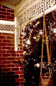
... 1930s to 1960s it was home to Miss Marjorie Vahland, a locally well-known nursing sister. See History Walks No 5, p 11 and p32 Surrey Hills In Celebration of its Centennial 1883-1983. tavistock milverton girls school victorian style houses Union road 1890-1900 joyce walker marjorie vahland Colour photo of the detail of the wrought iron decoration and the decorative tiles on the front verandah at Tavistock at 192 Union Road, Surrey Hills taken from the under the verandah during the period of restoration during 1978-1982. The house is Victorian in style, of red brick construction ...The date is approximate. Tavistock was built c1890. In 1897 it was the home of the Walker family; Joyce Walker later became matron of Mosgiel Hospital. In 1902 it became the first site of Milverton Girls School. From 1930s to 1960s it was home to Miss Marjorie Vahland, a locally well-known nursing sister. See History Walks No 5, p 11 and p32 Surrey Hills In Celebration of its Centennial 1883-1983.Colour photo of the detail of the wrought iron decoration and the decorative tiles on the front verandah at Tavistock at 192 Union Road, Surrey Hills taken from the under the verandah during the period of restoration during 1978-1982. The house is Victorian in style, of red brick construction with a patterned slate tile roof and decorative chimneys.tavistock, milverton girls school, victorian style, houses, union road, 1890-1900, joyce walker, marjorie vahland -
 Wodonga & District Historical Society Inc
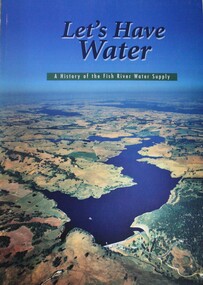
Book - Let's Have Water - A history of the Fish River Water Supply, Robin McLachlan, Denis Barrett, Jack Domis, Nick Welling, 1997
... Wodonga & District Historical Society Inc Hut 97, Bonegilla Migrant Experience, 132 Bonegilla Road Bonegilla the-murray The development of Fish River Water Supply Scheme (FRWS) was a response to the ongoing water supply shortages, during the 1930s, of Lithgow, Oberon and the communities of Blaxland Shire. Initial construction ...A history of the development of the management of the Fish River Water Supply Scheme in Central NSW. The scheme extends across the local government areas of the Shire of Oberon, the City of Lithgow and the City of the Blue Mountains.non-fictionA history of the development of the management of the Fish River Water Supply Scheme in Central NSW. The scheme extends across the local government areas of the Shire of Oberon, the City of Lithgow and the City of the Blue Mountains.water nsw, fish river region nsw, oberon dam, water resources development nsw australia -
 Whitehorse Historical Society Inc.
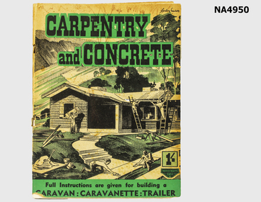
Book, 1939
... Whitehorse Historical Society Inc. 2-10 Deep Creek Road Mitcham melbourne Belonged to Bill McLaren (father of Anthea Swann) in the 1930s - 1940s books magazines trades carpentry Carpentry and Concrete 87 page magazine containing construction instruction for handymen and tradesmen. ...Belonged to Bill McLaren (father of Anthea Swann) in the 1930s - 1940s87 page magazine containing construction instruction for handymen and tradesmen. Title : Carpentry and Concrete: a Home Beautiful Handbook for Tradesmen and AmateursCarpentry and Concretebooks, magazines, trades, carpentry -
 Kew Historical Society Inc
Photograph - Kew Main Drain, 1984
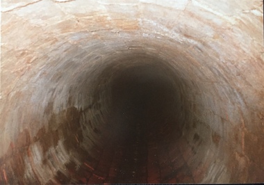
... Road at Kew High School before discharging into the Yarra River. The fourth drain, Kew Main Drain connects directly with the Yarra River to the West of Glass Creek.' The Kew Main Drain is a barrel drain that was created in the 1930s, and follows the route of the former Connor's Creek from the vicinity of Genazzano FCJ College to the Yarra River in East Kew Important and verifiable evidence of the construction methods used by the Melbourne & Metropolitan Board of Works in building the Kew Main Drain, before its reconstruction in c.1985. kew main drain stormwater drains -- kew (vic.) connor's creek -- kew (vic.) ...'Kew, Kew East, Balwyn & Balwyn North are located approximately 7km north east of Melbourne. Four main stormwater drains service the area flowing from south to north. Three of the drains: Deepdene Drain; Balwyn Drain & Glass Creek converge in Kew East just west of Burke Road at Kew High School before discharging into the Yarra River. The fourth drain, Kew Main Drain connects directly with the Yarra River to the West of Glass Creek.' The Kew Main Drain is a barrel drain that was created in the 1930s, and follows the route of the former Connor's Creek from the vicinity of Genazzano FCJ College to the Yarra River in East KewImportant and verifiable evidence of the construction methods used by the Melbourne & Metropolitan Board of Works in building the Kew Main Drain, before its reconstruction in c.1985.Original print colour positive photograph of the Kew Main Drain, provided on 14/12.84 to the Chief Engineer of the City of Kew, Ian Poulter, by the Supervising Engineer (Works), Southern and Eastern Drainage, Melbourne & Metropolitan Board of Works. The record includes an image of the reverse as well as the donation document from the MMBW."A84/1855-9 / 750mm council drain looking D/S [down stream] and across Parkhill Road. To be replaced with 1200 mm R.C.P. [reinforced concrete pipe] as part of MMBW Kew Main Drain reconstruction works"kew main drain, stormwater drains -- kew (vic.), connor's creek -- kew (vic.) -
 Kew Historical Society Inc
Photograph - Kew Main Drain, 1984
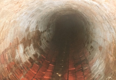
... Road at Kew High School before discharging into the Yarra River. The fourth drain, Kew Main Drain connects directly with the Yarra River to the West of Glass Creek.' The Kew Main Drain is a barrel drain that was created in the 1930s, and follows the route of the former Connor's Creek from the vicinity of Genazzano FCJ College to the Yarra River in East Kew Important and verifiable evidence of the construction methods used by the Melbourne & Metropolitan Board of Works in building the Kew Main Drain, before its reconstruction in c.1985. kew main drain stormwater drains -- kew (vic.) connor's creek -- kew (vic.) ...'Kew, Kew East, Balwyn & Balwyn North are located approximately 7km north east of Melbourne. Four main stormwater drains service the area flowing from south to north. Three of the drains: Deepdene Drain; Balwyn Drain & Glass Creek converge in Kew East just west of Burke Road at Kew High School before discharging into the Yarra River. The fourth drain, Kew Main Drain connects directly with the Yarra River to the West of Glass Creek.' The Kew Main Drain is a barrel drain that was created in the 1930s, and follows the route of the former Connor's Creek from the vicinity of Genazzano FCJ College to the Yarra River in East KewImportant and verifiable evidence of the construction methods used by the Melbourne & Metropolitan Board of Works in building the Kew Main Drain, before its reconstruction in c.1985.Original print colour positive photograph of the Kew Main Drain, provided on 14/12.84 to the Chief Engineer of the City of Kew, Ian Poulter, by the Supervising Engineer (Works), Southern and Eastern Drainage, Melbourne & Metropolitan Board of Works. The record includes an image of the reverse as well as the donation document from the MMBW."A84/1855-10 / 750mm council drain looking U/S [up stream] from Parkhill Road, Kew."kew main drain, stormwater drains -- kew (vic.), connor's creek -- kew (vic.) -
 Melbourne Tram Museum
Drawing, "Possible railway extensions from Sandringham"
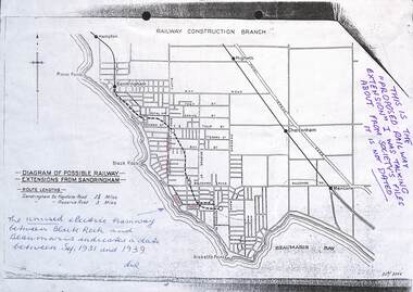
... Melbourne Tram Museum 8 Wallen Road Hawthorn melbourne Drawing, photocopied from the Sandringham and District Historical Society's files showing possible route and station locations of an extension from the Sandringham station. Prepared by the Railway Construction Branch of the Victorian Railways. Shows the tram lines. Possibly late 1930s ...Drawing, photocopied from the Sandringham and District Historical Society's files showing possible route and station locations of an extension from the Sandringham station. Prepared by the Railway Construction Branch of the Victorian Railways. Shows the tram lines. Possibly late 1930s.Yields information about a possible extension of the Sandringham railway line to Beaumaris.Drawing - photocopied with hand written notes - A4 sheetExtensive notes in ink.trams, railways, sandringham, beaumaris, new railways, railway construction branch -
 Melbourne Tram Museum
Negative - Copy - Y1 611 Wattle Park, Ray Pearson, early 1930s
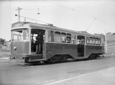
... Road, prior to the construction of the shops that were built behind the tram. The driver is standing in the open doorway. The tram line to the Wattle Park terminus opened in 1928. The tram entered service in 1930. Photo early 1930s...Road, prior to the construction of the shops that were built behind the tram. The driver is standing in the open doorway. The tram line to the Wattle Park terminus opened in 1928. The tram entered service in 1930. Photo early 1930s ...Copy negative of a photograph of Y1 611 at the Wattle Park terminus in Riversdale Road, prior to the construction of the shops that were built behind the tram. The driver is standing in the open doorway. The tram line to the Wattle Park terminus opened in 1928. The tram entered service in 1930. Photo early 1930s.Yields information about W5 808 soon after construction.Copy negative of a black and white photographtramcars, tramways, wattle park, y1 class, riversdale road, tram 611 -
 Melbourne Tram Museum
Postcard, Valentine's, "Swanston Street Melbourne", early 1930s
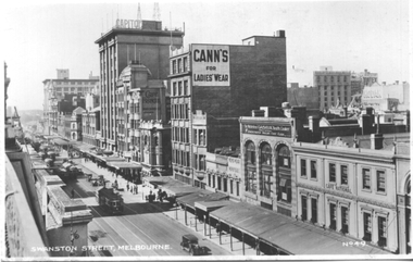
... Road Hawthorn melbourne Valentine's postcard titled "Swanston Street Melbourne", Number V49, looking south along Swanston St from Bourke St, Has about 9 W2 class trams in the view. Taken prior to the construction of the Manchester Unity building on the corner of Collins and Swanston Streets. The Capitol building, Cafe Frances, Cann's Ladies Wear, Gasava Health Cooker, Cafe National and Kodak are in the view. Yields information about Elizabeth St, during the early 1930s ...Valentine's postcard titled "Swanston Street Melbourne", Number V49, looking south along Swanston St from Bourke St, Has about 9 W2 class trams in the view. Taken prior to the construction of the Manchester Unity building on the corner of Collins and Swanston Streets. The Capitol building, Cafe Frances, Cann's Ladies Wear, Gasava Health Cooker, Cafe National and Kodak are in the view.Yields information about Elizabeth St, during the early 1930s.Postcard - printed, unused, Valentine Series - with a perforated edge on the left hand side.trams, tramways, swanston st, w2 class -
 Melbourne Tram Museum
Postcard, Rose Stereograph Co, "Princes Bridge and St Kilda Road Melbourne", late 1930s
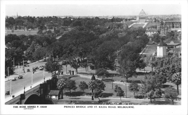
... Road to Mafra Street is Sloss Street, it was removed in the late 1960' for the construction of the National Arts Center. The former "Green Mill" dance hall built in 1926 become the "Forty Club" in 1933 and evolved to being the "Trocadero Palais" by the late 1930's can be seen on the right of the photo. The road on the south side of the Yarra River, at the bottom of the photo, is Riverside Avenue. Yields information about St Kilda Road, late 1930s ...Rose Series postcard No. P 10649, titled "Princes Bridge and St Kilda Road Melbourne", looking south from Flinders St station clock tower showing Princess Bridge and St. Kilda Road with a W2 class tram in the view at the intersection of City Road to the west and Alexandra Avenue to the east. In the background is the Shrine of Remembrance. To the west of St. Kilda Road running in parallel from City Road to Mafra Street is Sloss Street, it was removed in the late 1960' for the construction of the National Arts Center. The former "Green Mill" dance hall built in 1926 become the "Forty Club" in 1933 and evolved to being the "Trocadero Palais" by the late 1930's can be seen on the right of the photo. The road on the south side of the Yarra River, at the bottom of the photo, is Riverside Avenue. Yields information about St Kilda Road, late 1930s.Postcard - printed real photograph with Rose Stereograph Co. name on the rear.trams, shrine of remembrance, st kilda road, princes bridge, w2 class, tramways