Showing 174 items matching "rosa"
-
 Victorian Harness Racing Heritage Collection at Lord's Raceway Bendigo
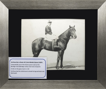
Photograph - Portrait, horse and jockey, George Daniel, Val Rosa, Pacer
... George Daniel, Val Rosa, Pacer...Large Silver framed photo of George Daniel riding the pacer Val Rosa...Val Rosa, George Daniel. Val Rosa by Le Rosier NZ from Mimbric Queen...Val Rosa by Le Rosier NZ from Mimbric Queen Large Silver framed photo of George Daniel riding the pacer Val Rosa George Daniel, Val Rosa, Pacer Photograph Portrait, horse and jockey ...From the collection of Morris Hesse, grandson of trainer/rider George DanielWon 1932 Bendigo Jockey Club Open, 1923 Boort CupLarge Silver framed photo of George Daniel riding the pacer Val RosaVal Rosa, George Daniel. Val Rosa by Le Rosier NZ from Mimbric Queentrotting, george daniel, val rosa, bendigo trotting, g daniel -
 Mont De Lancey
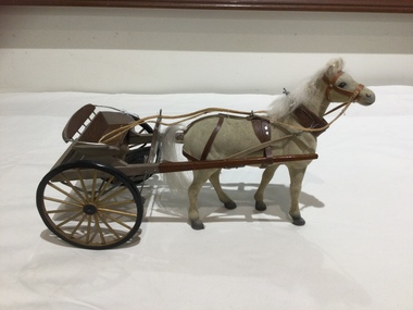
Decorative object - Horse Buggy Model, Chas W Davis, Rosa Buggy
... Rosa Buggy...This model of a horse drawn Rosa Buggy replicates the vehicle that enjoyed respect from the public during the 1880's. ...A model of a Rosa Buggy which is a lightweight two wheeled two passenger open horse drawn carriage where the driver sits behind. ...This model of a horse drawn Rosa Buggy replicates the vehicle that enjoyed respect from the public during the 1880's. ...The collection of thirteen model horse drawn vehicles were carefully handmade by Mr Chas W Davis 1925 - 2002. He was a talented artist and saw doctor. This model of a horse drawn Rosa Buggy replicates the vehicle that enjoyed respect from the public during the 1880's. There were four horse drawn models as well.A model of a Rosa Buggy which is a lightweight two wheeled two passenger open horse drawn carriage where the driver sits behind. It has two large gold painted spoked wheels with black rims, brown padded seating and silver painted armrests. There are two long brown wooden shafts on each side to surround the horse. It has a model of a cream coloured horse with a white tail and mane, which has the necessary horse tack for carriage use to help the driver communicate with the horse. It was designed by Duncan & Fraser of Adelaide initiated by the wife of one of the company's directors who gave it her name. It was a hybrid of the Dog Cart and Ralli Trap, a fair weather vehicle favoured by ladies of refinement. It was mounted on Brewster Gear and was inclined to bounce, so was driven gently.replicas, models, scale models, vehicles, carriages, horse drawn vehicles, toy horses -
 Ararat Gallery TAMA
Sara Lindsay, Rosa, 1978
... Rosa...Ararat Gallery TAMA 82 Vincent Street Ararat grampians Rosa Sara Lindsay ... -
 Tatura Irrigation & Wartime Camps Museum
Calendar, Rudolf Hofer and Rosa Hermann, 1946
... Made by internees Rudolf Hofer and Rosa Hermann at Camp 3 Tatura....Rudolf Hofer and Rosa Hermann...Calendar Rudolf Hofer and Rosa Hermann ...Made by internees Rudolf Hofer and Rosa Hermann at Camp 3 Tatura.Fawn coloured cards on each of which are picture postcards. e.g. the month of July depicts a farmer walking behind a black and white horse pulling 2 wooden implements. Calendar dates and picture postcards on each side of card and held together by red tape, threaded through punched holes. rudolf hofer, rosa hermann, calendar, camp 3 tatura, internees -
Tatura Irrigation & Wartime Camps Museum
Clothing - Child's Vest, Rosa Bacher nee Graze
... Made by Rosa Bacher, for Ingeborg Graze, aged 7, her niece, whilst in Camp 3....Rosa Bacher nee Graze...Clothing Child's Vest Rosa Bacher nee Graze ...Made by Rosa Bacher, for Ingeborg Graze, aged 7, her niece, whilst in Camp 3.Child's hand embroidered vest. ingeborg graze, camp 3 hand crafts, rosa bacher -
Tatura Irrigation & Wartime Camps Museum
Clothing - Child's dress with vest, Rosa Bacher nee Graze
... Made by Rosa Bacher, nee Graze, for her niece Ingeborg Graze, aged 7, whilst in Camp 3....Rosa Bacher nee Graze...Clothing Child's dress with vest Rosa Bacher nee Graze ...Made by Rosa Bacher, nee Graze, for her niece Ingeborg Graze, aged 7, whilst in Camp 3.Child's Crocheted vest and white frock.ingeborg graze, camp 3 hand crafts, rose bacher, rosa graze -
 Clunes Museum
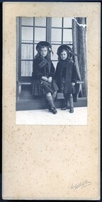
Photograph, RICHARDS & CO. ART STUDIO
... ...rosa...On Front: Richards & Co Ballarat On Reverse: Handwritten in black ink "To Miss Robertson with Christmas wishes from Elma and Rosa 1918"...Clunes Museum 36 Fraser Street enter building through Collins Place Clunes goldfields robertson rosa elma On Front: Richards & Co Ballarat On Reverse: Handwritten in black ink "To Miss Robertson with Christmas wishes from Elma and Rosa 1918" Black and white photograph mounted on cardboard of two young girls in Scottish regalia, seated in front of window Photograph PHOTOGRAPH RICHARDS & CO. ...Black and white photograph mounted on cardboard of two young girls in Scottish regalia, seated in front of windowOn Front: Richards & Co Ballarat On Reverse: Handwritten in black ink "To Miss Robertson with Christmas wishes from Elma and Rosa 1918"robertson, rosa, elma -
University of Melbourne, Burnley Campus Archives
Slide - Glass slide, 1891-1905
... Rosa - Classification - Part.' Handwritten page....University of Melbourne, Burnley Campus Archives 500 Yarra Boulevard Richmond melbourne history of the rose flowers classification Rosa - Classification - Part.' Handwritten page. ...Rosa - Classification - Part.' Handwritten page.history of the rose, flowers, classification -
Linton Mechanics Institute and Free Library Collection
Book - Novel, Le Voleur ( pseudonym of Rosa Nouchette Carey) et al, In the Tsar's dominions, 1899
... Le Voleur ( pseudonym of Rosa Nouchette Carey).... ; with illustrations by Ernest Dyer In the Tsar's dominions Book Novel Le Voleur ( pseudonym of Rosa Nouchette Carey) Hutchinson & Co. Cowan & Co Illustrations by Ernest Dyer ...408 p. ; with illustrations by Ernest Dyerfictionle voleur, fiction -
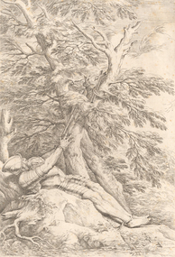 Geelong Gallery
Etching - St William of Maleval, ROSA, Salvator, 1661
... ROSA, Salvator...Geelong Gallery 55 Little Malop Street Geelong geelong-and-the-bellarine-peninsula Etching and drypoint Etching St William of Maleval ROSA, Salvator ...Etching and drypoint -
 Sunbury Family History and Heritage Society Inc.
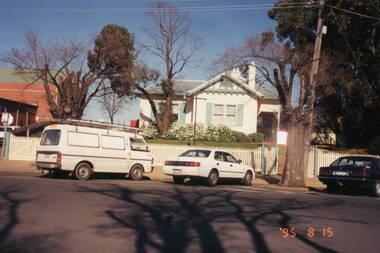
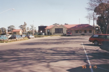
Photograph, Rosa McCall, 15th August 1995
... Rosa McCall...Four cars are parked outside the house. Photograph Rosa McCall ...The house was the former station master's residence. When the photograph was taken it served as a restaurant. In the late 1990s it was demolished to make way for larger commercial development.The former stationmaster's residence was one of the important railway buildings in Sunbury.A non-0digital coloured photograph of a cream weatherboard house with light green trims surrounded by a garden. Four cars are parked outside the house.sunbury railway station, stationmaster's residence, brook street -
 Sunbury Family History and Heritage Society Inc.
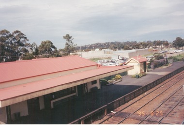
Photograph, Rosa McCall, 25 August 1995
... Rosa McCall...Sunbury Railway precinct has undergone a number of changes to cope with increased train services since the 19809s. sunbury Sunbury railway station A non-digital coloured photograph overlooking a railway station platform, carpark, commercial buildings and the area beyond the railway precinct. Photograph Rosa McCall ...The photograph is a view of Platform 1 at Sunbury Station after the station underwent refurbishment and the platform was extended in 1993 as well as the carpark on the east side of the tracks. The rear view of one of the shopping complexes is also visible as well as a view of the wider town area.Sunbury Railway precinct has undergone a number of changes to cope with increased train services since the 19809s.A non-digital coloured photograph overlooking a railway station platform, carpark, commercial buildings and the area beyond the railway precinct.sunbury, sunbury railway station -
 Sunbury Family History and Heritage Society Inc.
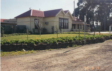
Photograph, Rosa McCall, 15th August 1995
... Rosa McCall...Sunbury railway station A non-digital coloured photograph of a garden in front of a weatherboard railway station with a gravel pathway in the foreground. Photograph Rosa McCall ...In 1993 Sunbury Railway Station underwent refurbishment and with some extensions added to the existing building. The Sunbury Garden Club undertook the task of constructing the garden on the east side of the station. The photograph was taken two years after the completion of the work. A non-digital coloured photograph of a garden in front of a weatherboard railway station with a gravel pathway in the foreground.sunbury railway station -
 Sunbury Family History and Heritage Society Inc.
Photograph, Rosa McCall, 25th August 1995
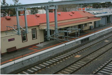
... Rosa McCall...Sunbury railway station brook street A non-digital coloured photograph of a streetscape with a weatherboard building in the middle distance, Photograph Rosa McCall ...This view of Sunbury Railway Station was taken from the corner of Brook and Evans Streets two years after the station underwent refurbishment and extensions and a carpark was constructed adjacent to the station. The Sunbury & District Heritage Association Inc. has a photograph P0663 of the station taken a century ago from the same place, when Sunbury was a small country town. The contrast between the two images is interesting. A non-digital coloured photograph of a streetscape with a weatherboard building in the middle distance,sunbury railway station, brook street -
 Sunbury Family History and Heritage Society Inc.
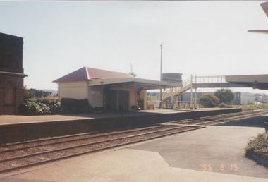
Photograph, Rosa McCall, 15th August 1995
... Rosa McCall...Sunbury railway station Railways A non-0digital coloured photograph of a platform at a railway station which includes a pedestrian bridge and a partial view of a metal water tower. Photograph Rosa McCall ...The Number 2 platform at Sunbury Station is featured in this image along with the former wooden pedestrian bridge and partial view of the two water towers, which in the past were used to supply water for the steam engines on their way to Bendigo.A non-0digital coloured photograph of a platform at a railway station which includes a pedestrian bridge and a partial view of a metal water tower. sunbury railway station, railways -
 Sunbury Family History and Heritage Society Inc.
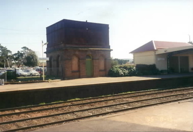
Photograph, Rosa McCall, 15th August 1995
... Rosa McCall...Water Tanks A non-digital coloured photograph of the water tower on platform 2 at Sunbury Railway Station. Photograph Rosa McCall ...Steam trains on the way to Bendigo stopped at Sunbury Station to refill the water tanks. After leaving Sunbury there was a long steep incline along the tracks so a lot of steam was needed to drive the engines.The water tank on Sunbury Station is of heritage interest.A non-digital coloured photograph of the water tower on platform 2 at Sunbury Railway Station.water tanks -
 Sunbury Family History and Heritage Society Inc.
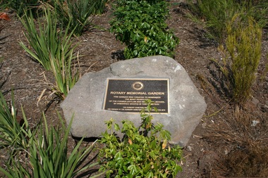
Photograph, Rosa McCall, Sunbury Cemetery, April 2014
... Rosa McCall...Sunbury Cemetery Photograph Rosa McCall ...In April 2014, the Rotary Memorial Garden was officially opened in the Sunbury Cemetery. The plaque in the garden was created to remember the former inmates of the Sunbury Asylum and the Industrial School who were buried in unmarked graves in the cemetery.Many former inmates of the Sunbury Asylum and the Industrial School were buried in unmarked graves in the Sunbury Cemetery.A non-digital coloured photograph of a plaque set in a large stone in a garden.memorials, sunbury cemetery, rotary club of sunbury, sunbury asylum -
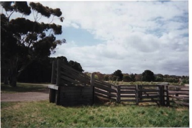 Sunbury Family History and Heritage Society Inc.
Photograph, Rosa McCall, 2001
... Rosa McCall...Cattle Yards Cornish Street Sunbury A scanned coloured photograph of an animal race-way in an empty cattle yard with trees in the background. Photograph Rosa McCall ...The former cattle yard was situated in Cornish Street in Sunbury adjacent to the tennis courts which are on the corner of Ligar and Cornish Streets.A scanned coloured photograph of an animal race-way in an empty cattle yard with trees in the background.cattle yards, cornish street, sunbury -
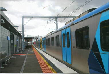 Sunbury Family History and Heritage Society Inc.
Photograph, Rosa McCall, November 2012
... Rosa McCall...Metro trains Electrification Railways Sunbury A coloured scanned photograph of a stationary electric train at a railway station. Photograph Rosa McCall ...The photograph was taken when the electrification of the railway line was completed to Sunbury in 2012 and the Metro train services commenced running in November.For 153 years Sunbury had relied on a regional train service to Melbourne. The extension of the electrified Metro service provided the town with more frequent services.A coloured scanned photograph of a stationary electric train at a railway station. metro trains, electrification, railways, sunbury -
 Sunbury Family History and Heritage Society Inc.
Photograph, Sunbury Railway Station, 2012
... Rosa McCall...Sunbury Railway Station Photograph Rosa McCall ...This is a photograph of the Sunbury Railway Terminal, looking north, taken shortly after the rail service became electrified in 2012. Prior to this date, Sunbury residents relied on the V Line service for their commute to Melbourne. The commercial development on either side of the rail tracks gradually took place from 2000 as Sunbury's population increased.A coloured photograph of a railway yard with extra rail tracks lines and the overhead electric lines. There is commercial development on either side of the rail tracks.sunbury railway station, electricity, metro train service, sunbury -
 Sunbury Family History and Heritage Society Inc.
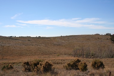
Photograph, Rosa McCall, 2020
... Rosa McCall...There are a number of work buildings on the river flat. Photograph Rosa McCall ...The photograph is a view of the Jacksons Creek downstream from Sunbury. The buildings are the Sunbury Sewerage Treatment plant, which is sited on the former Springvale Winery. It was built in 1974 when sewerage became a reality for Sunbury residents, thus doing away with the pan-man and septic tanks.Many settlements around Melbourne's urban fringe had sewerage systems installed in the 1970s as a result of Government legislation.A coloured photograph overlooking a river valley which is surrounded by hills with sparse trees on them. There are a number of work buildings on the river flat.sunbury sewerage treatment plant, jacksons creek, springvale winery -
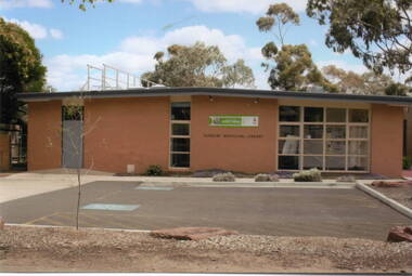
 Sunbury Family History and Heritage Society Inc.
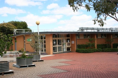
Photograph, Rosa McCall, Former Sunbury Library, December 2017
... Rosa McCall...Former Sunbury Library Photograph Rosa McCall ...The building in the photograph is the former Sunbury Library in Macedon Street, which closed in December 2017 to make way for the construction of a larger library, which was to be built on the site.A digital coloured photo of a wide, paved area with trees growing in metal containers in front of the main entrance to a flat-roofed cream-brick building. libraries, sunbury library, macedon street -
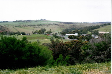
 Sunbury Family History and Heritage Society Inc.
Photograph, Rosa McCall, Sunbury Cultural Ring, May 2018
... Rosa McCall...Sunbury Cultural Ring Photograph Rosa McCall ...The photograph is of one of the Sunbury Cultural Rings sites. There are three Aboriginal earthen rings. The one in the foreground which is clear of weeds has been formed as a round dip in the earth and it is thought it was used as an Aboriginal gathering place. They are owned and managed by the Wurundjeri Tribe Land Council.The rings bear evidence of Aboriginal settlement and land use in the area. A coloured landscape photograph of open grassland and hills across the valley with a few native trees growing . aboriginal cultural rings, sunbury, jacksons creek, wurundjeri people -
 Sunbury Family History and Heritage Society Inc.
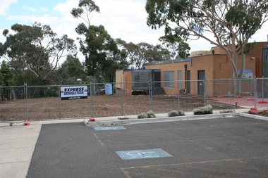
Photograph, Rosa McCall, 2nd January 2018
... Rosa McCall...Gum trees are growing in three background. Photograph Rosa McCall ...The former Sunbury Library was demolished and the empty site is ready for the construction of the new library. The existing building housed the George Evans Museum. A more modern Global Learning Centre is planned to be built on the site.A coloured photograph of a fenced site with a flat-roofed cream brick building adjacent to an area that has a been cleared in preparation for construction. A demolition sign is attached to the wire fence. Gum trees are growing in three background.libraries, global learning centre, sunbury, hume city council, macedon street, sunbury library -
 Sunbury Family History and Heritage Society Inc.
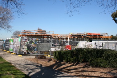
Photograph, Rosa McCall, 29th August 2018
... Rosa McCall...Signs attached to the fence indicate that the construction of the new Sunbury Global Learning Centre is taking place on the site. Photograph Rosa McCall ...The photograph was taken in August 2018, six months after the construction of the new Sunbury Global Learning Centre began.A coloured photograph of a fenced-off construction site. The ground floor of the building is visible above the fence line. Signs attached to the fence indicate that the construction of the new Sunbury Global Learning Centre is taking place on the site.libraries, construction sites, sunbury global learning centre, macedon street -
 Sunbury Family History and Heritage Society Inc.
Photograph, Rosa McCall, Sunbury Station, November 2012
... Rosa McCall...Sunbury Station Photograph Rosa McCall ...Renovations and extensions were carried out at Sunbury Railway Station from 2010 to 2012 accommodate the electrification of the rail service from Watergardens to Sunbury. The grey buildings adjacent to the wooden building are the extensions on Platform 1. Both Platforms 1 and 2 were raised and extended to accommodate the electric trains. The old building on Platform 2 was replaced with a newer one. The smaller wooden bridge linking the two platforms was replaced with a higher one which had ramps as well as stairs. In November 2012, electric trains began terminating at Sunbury.Prior to 201to commute to and from Melbourne, Sunbury residents relied on steam trains which commenced in 1859. From the 1960s diesel driven engines gradually replaced the steam trains.A coloured photograph of weatherboard building with a red corrugated roof of a railway station along with the platform and some of the rail tracks and overhead wires.sunbury rail crossing, metro train service, sunbury -
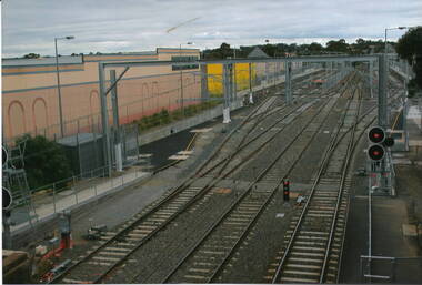
 Sunbury Family History and Heritage Society Inc.
Photograph, Rosa McCall, November 2012
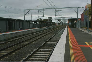
... Rosa McCall...Sunbury Railway Station Electrification Metro Trains Railway stations A coloured photograph of a railway station showing the two platforms and the extent of the rail tracks as well as the newly installed overhear wires. Photograph Rosa McCall ...The electrified rail service was extended from Watergardens to Sunbury in 2012. To accommodate the electric trains adjustments were carried out at Sunbury Station. The photograph, looking towards the south, was taken when all the works were completed. A coloured photograph of a railway station showing the two platforms and the extent of the rail tracks as well as the newly installed overhear wires. sunbury railway station, electrification, metro trains, railway stations -
 Sunbury Family History and Heritage Society Inc.
Photograph, Rosa McCall, Sunbury Shopping Square, 2011
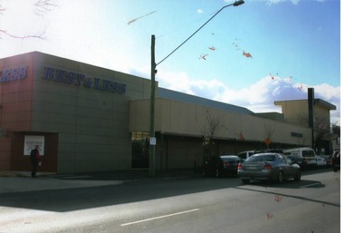
... Rosa McCall...Sunbury Shopping Square Photograph Rosa McCall ...The shopping complex is in Evans Street, Sunbury and it was built on the land that was a former sports ground and also housed the first CFA building in Sunbury and the scout hall. The shopping complex opened own the site in late 1989.This was the first large shopping complex to be built in Sunbury. Three more shopping areas were built in Sunbury between 1990 and 2005 on former railway land.A coloured photograph of a shopping complex in a Main Street with cars angle parked along the kerb.evans street, shopping complex, sunbury shopping square -
 Sunbury Family History and Heritage Society Inc.
Photograph, Rosa McCall, Sunbury Asylum Boiler House, 2011
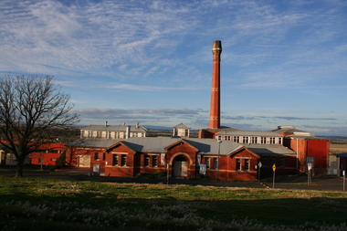
... Rosa McCall...Sunbury Asylum Boiler House Photograph Rosa McCall ...The building was the boiler house at the former Sunbury Asylum, which was built in 1920. It supplied hot water for heating, washing and cleaning to the entire Asylum complex. It ceased operation in 1994 when the Asylum was closed. Since then the site has accommodated the local arts and cultural community.The building, along with others in the Asylum complex, is of local heritage significance for its structure and its operation.A coloured photograph looking down on a sprawling red - brick building with a decorative tall chimney set in an open area.boiler house, sunbury asylum, sunbury art group -
 Sunbury Family History and Heritage Society Inc.
Photograph, Rosa McCall, Former Sunbury Library, December 2017
... Rosa McCall...The words 'Sunbury Municipal Library' are written across the brickwork Former Sunbury Library Photograph Rosa McCall ...The former Sunbury library built in the 1970s closed in December 2017 to make way for the construction of a more modern Global Learning Centre on the same site. During the building work, the library functioned in a temporary building in the shopping centre in Evans Street. The new library opened in November 2019.The new library provided more up to date internet services that were unable to be included in the old building.A coloured photograph of a cream brick building with large windows and a low pitched roof. A small car park area is in the front. A small garden bed is bordering the car park. The words 'Sunbury Municipal Library' are written across the brickworkSunbury Municipal Librarysunbury municipal library, libraries, global learning centre