Showing 20 items matching "shaft depths"
-
 Bendigo Historical Society Inc.
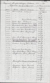
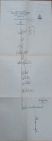
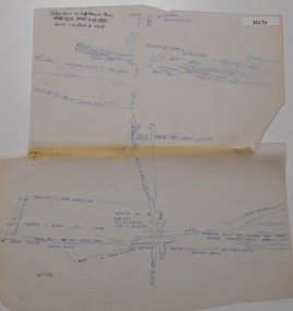
Document - ALBERT RICHARDSON COLLECTION: DEEPEST SHAFT AND WINZES VICTORIA 1851 - 1911
... ...shaft depths...History House 11 Mackenzie Street Bendigo goldfields BENDIGO Mining shaft depths Albert Richardson Handwritten, 2 page, table of information showing mine name, alluvial or quartz and shaft depth. ...Handwritten, 2 page, table of information showing mine name, alluvial or quartz and shaft depth. On top of page ' Deepest shafts and winzes Victoria 1851 - 1911. Reference: See Mines Report 1911, E.J. Dunn 10.11.08' Victoria Quartz mine Bendigo was the deepest. For example, entry reads: Victoria Quartz Mine, Bendigo, shaft 4270 plus 220 feet = total 4490 feet. Winze 385 feet from 4228 feet , No 37 Plat. Total 4613 feet from surface. Penthouse and cistern at 4228 feet. Shaft sunk to 4558 feet. Signed A.R.Albert Richardsonbendigo, mining, shaft depths -
 Bendigo Historical Society Inc.
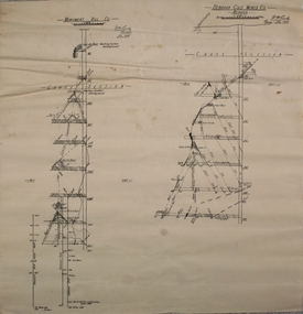
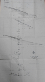
Plan - Deborah Gold Mine and Monument Hill Gold Mine
... Drawn on paper, cross sections of Deborah and Monument Hill Gold Mines, Bendigo. Plan shows shaft depths and drives. Written alongside each plan" W.H. ...Deborah Gold Mine and Monument Hill Gold Mine Margaret Roberts gold gold mine Bendigo Deborah Gold Mine and Monument Hill Gold Mine Monument Hill Gold Mine Deborah Gold Mine Drawn on paper, cross sections of Deborah and Monument Hill Gold Mines, Bendigo. Plan shows shaft depths and drives. Written alongside each plan" W.H. ...Deborah Gold Mine and Monument Hill Gold Mine Drawn on paper, cross sections of Deborah and Monument Hill Gold Mines, Bendigo. Plan shows shaft depths and drives. Written alongside each plan" W.H. Cundy, Bendigo, July 1934' Plan forms part of the Margaret Roberts Collection of mining records. margaret roberts, gold, gold mine, bendigo, deborah gold mine and monument hill gold mine, monument hill gold mine, deborah gold mine -
 Bendigo Historical Society Inc.
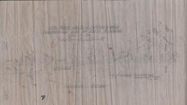
Map - RED WHITE & BLUE EXTENDED - PLAN OF RED WHITE AND BLUE EXTENDED MINE TRANSVERSE SECTION
... Transverse section of the Red White & Blue Extended Mine on the Sheepshead Line of Reef showing shafts, depths and geological features. Drawn on tracing film in pencil. ...History House 11 Mackenzie Street Bendigo goldfields DOCUMENT Gold red white & blue extended Red White & Blue Extended Plan of Red White & Blue Extended Mine Transverse Section J J Caldwell Mines Dept Bendigo Transverse section of the Red White & Blue Extended Mine on the Sheepshead Line of Reef showing shafts, depths and geological features. Drawn on tracing film in pencil. ...Transverse section of the Red White & Blue Extended Mine on the Sheepshead Line of Reef showing shafts, depths and geological features. Drawn on tracing film in pencil. Signed by J J Caldwell, District Field Geologist, Mines Department, Bendigo and dated 5/12/1940. Notes prepared by Albert Richardson.document, gold, red white & blue extended, red white & blue extended, plan of red white & blue extended mine transverse section, j j caldwell, mines dept bendigo -
 Bendigo Historical Society Inc.
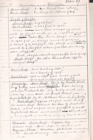
Document - ALBERT RICHARDSON COLLECTION: Hercules and Energetic Mines, Albert Richardson, 1970's
... Information includes depths of shafts; locality; plant; engine room and gold obtained. ...Information includes depths of shafts; locality; plant; engine room and gold obtained. ...The Hercules Mine was at Long Gully. It had a depth of 2383 feet ; 113,049 ounces of gold was obtained from the mine. Albert Richardson was a President of the Bendigo Historical Society. He had a great interest in the history of the Bendigo goldfield. A reserve in Marong Road, adjoining Victoria Hill mine precint, is named in honour of Albert and his contribution to recording the history of Bendigo. Eight page photocopied document, originally written by Albert Richardson, of information on the Hercules and Energetic mines on the New Chum line of reef at Long Gully. Information includes depths of shafts; locality; plant; engine room and gold obtained. gold mine, new chum reef line, hercules and energetic, albert richardson -
 Bendigo Historical Society Inc.
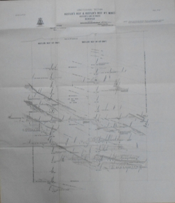
Map - GREAT EXTENDED HUSTLER'S MINE - PLAN OF THE GREAT EXTENDED HUSTLER'S MINE
... Shows No 2 Shaft, Latham & Watson's Shaft, levels and their depths and some geographical features. ...Shows No 2 Shaft, Latham & Watson's Shaft, levels and their depths and some geographical features. ...Plan of the Great Extended Hustler's Mine. Bulletin No 33, Plate No XI. Shows No 2 Shaft, Latham & Watson's Shaft, levels and their depths and some geographical features. Geographical Survey of Victoria emblem and signed by H A Whitelaw, Underground Survey Office, Bendigo, September 1913. Has reference to photos.mining, parish map, great extended hustler's mine, no 2 shaft, latham & watson's shaft, geological survey of victoria, underground survey office bendigo, h a whitelaw -
 Bendigo Historical Society Inc.
Map - HUSTLER'S & CHRISTMAS LINES OF REEFS - PLAN OF LINES OF SECTION OF REEFS
... depths and geological features. Drawing is continued in three parts to fit on paper. Lansell's East Shaft with levels and depths, geological features and stone encountered. ...depths and geological features. Drawing is continued in three parts to fit on paper. Lansell's East Shaft with levels and depths, geological features and stone encountered. ...Underground Survey of Mines Bendigo. Plan of Cross Section Lines Shewing Connections with Trigonometrical Stations and Base Lines. 13/3/99 Signed ? Stirling. Places and mines mentioned Speciman Hill, Tambour Major, Lansell's 180, Victory and Pandora, Great Extended Hustler's, Windmill Hill on Victoria Reef. Next part of map is a Plan of Lines of Section between the Hustler's and Christmas Lines of Reefs. 8/3/99. Signed ?. Transverse Section. Shows Tambour Major Co., near the Christmas Line of Reef, Crosscuts and their depth, geological features and stone encountered. Then shows Thistle Line, Charshalton Line, Napoleon Line, Nell Gwynne Line, New Chum Line, Lansell's No 180 with levels, depths and geological features. Drawing is continued in three parts to fit on paper. Lansell's East Shaft with levels and depths, geological features and stone encountered. Sheepshead Line, Old Shaft, Garden Gully Line, Victory and Pabndora Co with crosscuts, depths, geological features and stone encountered. Paddy's Gully Line, Derby Line, Millers Line, Hustler's Line, Great Extended Hustler's Co with levels, depths, geological features and stone encountered. A note beside a Saddle Reef: 360,000 pounds paid in dividends from this reef. Average ounces per ton gold noted where found. Reference Table for stone and geological features. Datum Line 700 feet above Sea Level Unscannedmining, parish map, hustler's & christmas lines of reefs, plan of lines of section of reefs, ? stirling, specimen hill, tambour major, lansell's 180, victory & pandora, great extended hustler's, windmill hill, victoria reef, tambour major co, christmas line, hustler's line, thistle line, carshalton line, napoleon line, nell gwynne line, new chum line, lansell's no 180, lansell's east shaft, sheepshead line, old shaft, garden gully line, paddy's gully line, derby line, miller's line, hustler's line, great extended hustler's co -
 Bendigo Historical Society Inc.
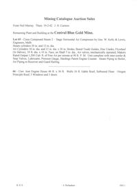
Book - AUCTION SALES: MINING CATALOGUE AUCTION SALES
... Dunn's Report 13/8/92 on the Lazarus Mine Old Shaft and Lazarus Main Shaft at various depths. Book not located on 6.3.25. ...Dunn's Report 13/8/92 on the Lazarus Mine Old Shaft and Lazarus Main Shaft at various depths. Book not located on 6.3.25. ...Blue, black & white Woolstar exercise book with black & white check pattern to the left and a world globe over the top. Name on the front: A Richardson. Written on the front: Mining Catalogue Auction Sales. Book contains Lot numbers and description for auction sales at various mines. Mines mentioned are: Central Blue Gold Mine 19/2/42, Big Blue 23/11/1938, South Blue, Hercules Consols 19/2/1942, South Virginia 19/2/42, New Prince of Wales 5/2/48, Golden Carshalton G M 19/12/1957, North Virginia 3/5/57, North Nell Gwynne 25/2/53, South Shaft Diamond Hill, New Don 21/10/48, Sheepshead Battery Site 21/10/48, Forbes Carshalton 9/7/47, South Virginia 9/7/47, East Clarence 31/8/49?, Deborah Surplus Equipment 31/8/49, Deborah No 2 Shaft, North Deborah 31/8/49, Hercules Main Shaft 19/6/1950, Stanfield Shaft 20/6/1950, United Crushing Coy Battery (Unity Carlisle) 20/6/1950, Toolleen Gold Mine 23/2/1950, Ironbark Gold Mine 6/10/49, Ironbark South 1/12/49, Hercules New Chum 1/12/49, Great Southern Gold Mine 10/4/47, New Chum Syncline 2/3/1950, Deborah Associated 19/4/195? And the Deborah Consolidated 19/4/1950. Further information of Bendigo Mines from The Gold Mining Registry Guide to Bendigo Mines by H Kirkwood, Eaglehawk. Published by W. Welch. Mines include Lazarus New Chum Reg'd & Lazarus New Chum No 1, Princess Alexandra, Ellenborough, Trio-Hauling Coy, South Catherine Reef G. M. C., Princess Alice, Central Catherine Co,Cravens New Chum Co N. L., Garibaldi Mining and Crushing Co, Williams United, Catherine Reef Claimholders G. M. N. L., New Chum & Victoria Reef, Johnsons (Garden Gully) Line, United Ulster, Garden Gully Rly Reserve, South Ulster, Ulster and Cosmopolitan Coys, Golden Gate and Lansell'sBig 180. Some information on the Moon Mines 24/6/67 South New Moon, New Moon, Nth New Moon and New Moon Consolidated.In the reverseof the book is some information on the Lazarus New Chum Mine, Lazarus No 1 and Lazarus Mines. Also mentioned are New Chum Rly and Victoria Quartz. In 1895 a large gold bearing reef in Lazarus at 3000 feet. Also Some extracts from E. C. Dunn's Report 13/8/92 on the Lazarus Mine Old Shaft and Lazarus Main Shaft at various depths. Book not located on 6.3.25. Typed notes from book are in folder.book, bendigo, mining auction sales, auction sales, mining catalogue auction sales, a richardson, central blue g m, big blue, south blue, hercules consols, south virginia, new prince of wales, golden carshalton g m, north virginia, north nell gwynne, south shaft diamond hill, new don, sheepshead battery site, forbes carshalton, south virginia, east clarence, deborah, deborah no 2 shaft, north deborah, hercules main shaft, stanfield shaft, united crushing coy battery (unity carlisle), toolleen gold mine - toolleen, ironbark gold mine, ironbark south, hercules new chum, great southern gold mine, new chum syncline, deborah associated, deborah consolidated, j h curnow, miss kirkwood, the gold mining registry guide to bendigo mines, h kirkwood, w welch, lazarus new chum no 1, mr g armstrong, princess alexandra, h hectmann, ellenborough, amos arblaster, trio hauling coy, catherine reef g m c, w burnside, st mungo reef, princess alice, central catherine co, big catherine, belmont, cravens new chum co n l, wm w barker, c edwards, ellesmere, garibaldi mining and crushing co, henry von der heyde, w martin, williams united, wm cook, john chynowth, catherine reef claimholders g m n l, churchill davidson, edgar l rosman, new chum and victoria reef, johnsons (garden gully) line, united ulster, james mccoll, james quick, garden gully reserve, south ulster, ulster and cosmopolitan coys, golden gate, geo lansell's big 180, signal of a mine, mr langridge, e clarke, j hattam, a llewelly, n murray, a richardson, new moon, nth new moon, new moon consolidated, lazarus new chum, lazarus no 1, new chum rly, victoria quartz, lazarus, e c dunn -
 Bendigo Historical Society Inc.
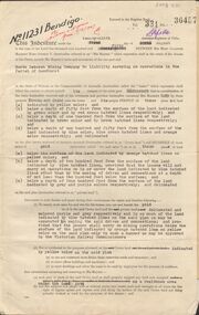
Document - MCCOLL, RANKIN AND STANISTREET COLLECTION: GOLD MINING LEASE NORTH DEBORAH MINING COMPANY, 29th August, 1950
... Shafts and tracks indicated. Dam shown on lease 11013. Scale 8 CHAINS TO A INCH. Coloured key to plan shows depths, Crown Land, and surface excised. ...Shafts and tracks indicated. Dam shown on lease 11013. Scale 8 CHAINS TO A INCH. Coloured key to plan shows depths, Crown Land, and surface excised. ...6 page indenture, plus plan, between King George V and North Deborah Mining Company in the Parish of Sandhurst, dated 29th August, 1950 to operate a gold mine. Indenture numbered 11231 Bendigo, Vol 331 and Folio 36457. Plan shows Hargreaves Street, Violet Street, Lily Street, Sullivan Street railway line, and leases numbered, 11230; 2107; 11062, 11033, 11013, 11219, 11175. Shafts and tracks indicated. Dam shown on lease 11013. Scale 8 CHAINS TO A INCH. Coloured key to plan shows depths, Crown Land, and surface excised. Total area of lease 48 acres, 3 roods, 22 perches.bendigo, mining, north deborag mining company, north deborah mining company, hargreaves, violet, lilly, sullivan streets. -
 Bendigo Historical Society Inc.
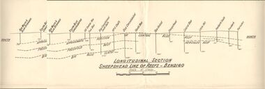
Document - AUSTIN COLLECTION: SHEEPSHEAD LINE OF REEF PLAN
... depths, along the reef line. Reefs marked on plan: Central Blue Reef, Freehold Reef, Big Blue Slates, Central Clue Reef and Hercules Reef. From the south of the reef : Red, White & Blue Extended, South Blue Consolidated, Old Central Blue, True Blue, Blue consolidated South Shaft, No. 3 Shaft, Blue Consolidated, North Blue, Blue United, sheepshead, Central Blue, Little 180, Ironbark South, Ironbark, Hercules. ...depths, along the reef line. Reefs marked on plan: Central Blue Reef, Freehold Reef, Big Blue Slates, Central Clue Reef and Hercules Reef. From the south of the reef : Red, White & Blue Extended, South Blue Consolidated, Old Central Blue, True Blue, Blue consolidated South Shaft, No. 3 Shaft, Blue Consolidated, North Blue, Blue United, sheepshead, Central Blue, Little 180, Ironbark South, Ironbark, Hercules. ...BHS CollectionLongitudinal plan of the Sheepshead line of reefs, showing the mines and their sites and depths, along the reef line. Reefs marked on plan: Central Blue Reef, Freehold Reef, Big Blue Slates, Central Clue Reef and Hercules Reef. From the south of the reef : Red, White & Blue Extended, South Blue Consolidated, Old Central Blue, True Blue, Blue consolidated South Shaft, No. 3 Shaft, Blue Consolidated, North Blue, Blue United, sheepshead, Central Blue, Little 180, Ironbark South, Ironbark, Hercules. Written on bottom of plan: ' Longitudinal Section Sheepshead Line of Reefs - Bendigo'.bendigo, mining, sheepshead reef -
 Bendigo Historical Society Inc.
Document - LANSELL'S BIG 180 MINE - CONDENSED HISTORICAL RECORD OF LANSELL'S BIG 180 MINE
... Notes include location, shaft, first worked, size of lease, plant, engine house, boiler rooms, mullock heap, early history, Prominent, best gold, underground connections, pressurised hot water, diamond drill bores and a table with depths and the increase in temperature with the depth (in Fahr). ...Notes include location, shaft, first worked, size of lease, plant, engine house, boiler rooms, mullock heap, early history, Prominent, best gold, underground connections, pressurised hot water, diamond drill bores and a table with depths and the increase in temperature with the depth (in Fahr). ...Two handwritten and three typed copies of a Condensed Historical Record of Lansell's Big 180 Mine on the New Chum Line of Reef. Notes include location, shaft, first worked, size of lease, plant, engine house, boiler rooms, mullock heap, early history, Prominent, best gold, underground connections, pressurised hot water, diamond drill bores and a table with depths and the increase in temperature with the depth (in Fahr). Albert Richardson Collection. document, gold, lansell's big 180 mine, lansell's big 180 mine, condensed historical record of lansell's big 180 mine, wittscheibe, ballerstadt, ernst mueller, theodore ballerstadt, george lansell, north old chum, victoria quartz, mines dept special edition 'australian mining standard' 1/6/1899, mines dept booklet 'bendigo goldfield' 1936, quarterly reports, lansell's 180 mine 'transverse sections, annals of bendigo mining sections, a richardson's observations from old photographs and measurements of mining plans, measurements taked from caleb thomas' report mines dept 1875, 'report on observation of underground temperature at bendigo' james stirling government geologist 1899, a richardson -
 Bendigo Historical Society Inc.
Map - GREAT EXTENDED HUSTLER'S MINE - LONGITUDINAL SECTION OF THE GREAT EXTENDED HUSTLER'S MINE
... Poppet Legs on the surface and Sill of Shaft 788.99 feet above Sea Level. Levels and their depths are shown and some geographical features. ...Poppet Legs on the surface and Sill of Shaft 788.99 feet above Sea Level. Levels and their depths are shown and some geographical features. ...Longitudinal Section of the Great Extended Hustler's Mine on the Hustler's Line of Reefs. Bulletin No 33, Plate No XIII. Map shows the Hustler's Tribute, 2 Old Shafts, Great Extended Hustler's Shaft, Latham & Watson's Shaft and Ironbark Gully. Datum Line 750 feet above Sea Level. Poppet Legs on the surface and Sill of Shaft 788.99 feet above Sea Level. Levels and their depths are shown and some geographical features. Some amounts of gold mined mentioned. Geological Survey of Victoria emblem and signed by H A Whitelaw, Underground Survey Office Bendigo, September 1913. Note - Plates 4, 8, 13,20, 26 & 31 form a Longitudinal Section from Fortuna Hustlers to Hustler's Consols Mine. mining, parish map, great extended hustler's mine, geological survey of victoria, underground survey office bendigo, h a whitelaw, hustler's tribute, old shaft, great extended hustler's shaft, latham & watson's shaft, ironbark gully -
 Bendigo Historical Society Inc.
Map - GREAT EXTENDED HUSTLER'S MINE - TRANSVERSE SECTION OF THE GREAT EXTENDED HUSTLER'S MINE
... Shows Poppet legs at the surface and Sill of Shaft at 788.99 feet above Sea Level, Cross Cuts and their depths, stone and geographical features encountered and their references and a number of enlarged drawing of sections of the crosscuts, Geological Survey of Victoria emblem and signed by H A Whitelaw, Underground Survey Office Bendigo, September 1913. ...Shows Poppet legs at the surface and Sill of Shaft at 788.99 feet above Sea Level, Cross Cuts and their depths, stone and geographical features encountered and their references and a number of enlarged drawing of sections of the crosscuts, Geological Survey of Victoria emblem and signed by H A Whitelaw, Underground Survey Office Bendigo, September 1913. ...Transverse Section of the Great Extended Hustler's Mine on the Hustler's Line of Reef. Bulletin No 33, Plate No XII. Shows Poppet legs at the surface and Sill of Shaft at 788.99 feet above Sea Level, Cross Cuts and their depths, stone and geographical features encountered and their references and a number of enlarged drawing of sections of the crosscuts, Geological Survey of Victoria emblem and signed by H A Whitelaw, Underground Survey Office Bendigo, September 1913. The depths of crosscuts to No 21 were taken from plans of surveys by Mr. Walker and Mr. Craven, noted under Reference. Another note: This Saddle Reef is sketched from Mr. Walker's plan. Dividends amounting to 360,000 pounds were obtained from it. mining, parish map, great extended hustler's mine, transverse section of the great extended hustler's mine, old shaft, mr walker, mr craven, geological survey of victoria, underground survey office bendigo, h a whitelaw -
 Bendigo Historical Society Inc.
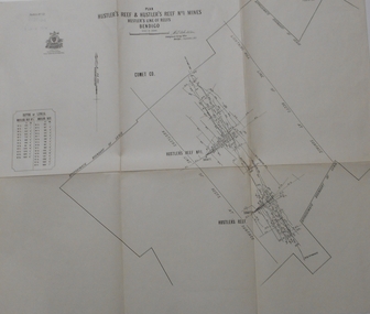
Map - GREAT EXTENDED HUSTLER'S MINE - PLAN OF THE GREAT EXTENDED HUSTLER'S MINE
... Latham & Watson's Shaft is also mentioned. Levels are numbered and a table shows the Levels and their Depths. ...Shaft is also mentioned. Levels are numbered and a table shows the Levels and their Depths. ...Plan of the Great Extended Hustler's Mine on the Hustler's Line of Reefs, Bendigo. Bulletin No 33, Plate No X. Lease No 7382. Plan has map of streets. Mine was located in the block bounded by Langston and Anderson Streets and was between the Hustler's Anticline at Surface and the Lightning Hill Anticline at Surface. Latham & Watson's Shaft is also mentioned. Levels are numbered and a table shows the Levels and their Depths. Geological Survey of Victoria. Signed by H A Whitelaw, Underground Survey Office, Bendigo, September 1913. This item has not been scanned or photographed.mining, parish map, great extended hustler's mine, hustler's line of reefs, mining lease no 7382, geological survey of victoria, underground survey office bendigo, h a whitelaw, latham & watson's shaft -
 Bendigo Historical Society Inc.
Map - FORTUNA HUSTLER'S MINE - TRANSVERSE SECTION OF THE FORTUNA HUSTLER'S MINE
... Drawing shows poppet legs on the surface and Sill of Shaft 745.38 feet above Sea Level. Shows levels and their depths, geographical features and stone encountered. ...Drawing shows poppet legs on the surface and Sill of Shaft 745.38 feet above Sea Level. Shows levels and their depths, geographical features and stone encountered. ...Transverse Section of the Fortuna Hustler's Mine on the Hustler's Line of Reef, Bendigo. Bulletin No 33, Plate No III. Drawing shows poppet legs on the surface and Sill of Shaft 745.38 feet above Sea Level. Shows levels and their depths, geographical features and stone encountered. Reference table to stone and geographical features. Geographical Survey of Victoria emblem. Signed by H A Whitelaw, Underground Survey Office, Bendigo. mining, fortuna hustler's mine, hustler's line of reef, geological survey of victoria, underground survey office bendigo, h a whitelaw -
 Bendigo Historical Society Inc.
Map - HUSTLER'S CONSOLS MINE - TRANSVERSE SECTION OF THE HUSTLER'S CONSOLS MINE
... Map shows poppet legs at the surface and Sill of Shaft 779.42 feet above Sea Level. Shows the different levels and their depths and the different stone and geographical features encountered. ...Map shows poppet legs at the surface and Sill of Shaft 779.42 feet above Sea Level. Shows the different levels and their depths and the different stone and geographical features encountered. ...Transverse Section of the Hustler's Consols Mine Bulletin No 33, Plate No XXXIII. Map shows poppet legs at the surface and Sill of Shaft 779.42 feet above Sea Level. Shows the different levels and their depths and the different stone and geographical features encountered. Has larger drawing of Section A - B. Geographical Survey of Victoria. Signed by H A Whitelaw, Underground Survey Office Bendigo, September 1913. mining, parish map, hustler's consols mine, transverse section of the hustler's consols mine, geological survey of victoria, underground survey office bendigo, h a whitelaw -
 Bendigo Historical Society Inc.
Map - HUSTLER'S REEF & HUSTLER'S REEF NO 1 MINES - LONGITUDINAL SECTION OF THE HUSTLER'S REEF & HUSTLER'S
... Shows the two shafts with their levels and depths. Also shows geographical features and yields of gold and amalgam per ton. ....Shows the two shafts with their levels and depths. Also shows geographical features and yields of gold and amalgam per ton. . ...Longitudinal Section of the Hustler's Reef & Hustler's Reef No 1 Mines on the Hustler's Line of Reef. Bulletin No 33, Plate No XX. Note - Plates 4, 8, 13, 20, 26 & 31 form a Longitudinal Section from Fortuna Hustler's to Hustler's Consols Mine. Geological Survey of Victoria emblem. Signed by H A Whitelaw, Underground Survey Office Bendigo, September 1913. Shows the two shafts with their levels and depths. Also shows geographical features and yields of gold and amalgam per ton. .mining, parish map, hustler's reef & hustler's reef no 1 mines, geographical survey of victoria, underground survey office bendigo, h a whitelaw -
 Bendigo Historical Society Inc.
Map - HUSTLER'S REEF & HUSTLER'S REEF NO 1 MINES - PLAN OF THE HUSTLER'S REEF & HUSTLER'S REEF NO 1 MINES
... Map shows different levels in relation to the two shafts, the lines of the Hustler's Line of Reefs and the Lightning Hill Line of Reefs, the approximate Boundary of Lease and the Comet Co., the adjoining lease. Table on the left shows the levels and their depths...Map shows different levels in relation to the two shafts, the lines of the Hustler's Line of Reefs and the Lightning Hill Line of Reefs, the approximate Boundary of Lease and the Comet Co., the adjoining lease. Table on the left shows the levels and their depths ...Plan of the Hustler's Reef & Hustler's Reef No 1 Mines on the Hustler's Line of Reefs, Bendigo Bulletin No 33, Plate No XIV. No 8 connecting No 10 (Hustler's Reef), No 11 connecting No 13 (Hustler's Reef), No 13 (Hustler's Reef No 1) connecting No 15 (Hustler's Reef) and No 10 Hustler's Reef No 1 rise to Comet Mine. Map shows different levels in relation to the two shafts, the lines of the Hustler's Line of Reefs and the Lightning Hill Line of Reefs, the approximate Boundary of Lease and the Comet Co., the adjoining lease. Table on the left shows the levels and their depths of the two mines. Signed by H A Whitelaw, Underground Survey Office, Bendigo, September 1913. Geological Survey of Victoria emblem. mining, parish map, hustler's reef & hustler's reef no 1 mines, hustler's line of reefs lightning hill line of reefs, comet co., h a whitelaw, underground survey office bendigo, geological survey of victoria -
 Bendigo Historical Society Inc.
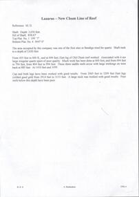
Document - THE LAZARUS MINE - NOTES ON THE LAZARUS MINE
... Notes include depth of shaft, Sill of shaft, Depth of Top Plat No 1 and Bottom Plat No 4, brief history, depths where work was done and some of the results. ...Notes include depth of shaft, Sill of shaft, Depth of Top Plat No 1 and Bottom Plat No 4, brief history, depths where work was done and some of the results. ...Handwritten notes and typed copy describing the Lazarus Mine on the New Chum Line of Reef. Notes include depth of shaft, Sill of shaft, Depth of Top Plat No 1 and Bottom Plat No 4, brief history, depths where work was done and some of the results. Notes prepared by Albert Richardson.document, gold, the lazarus mine, the lazarus mine, notes on the lazarus mine, new chum line of reef, m d -
 Bendigo Historical Society Inc.
Map - DEVONSHIRE MINES - MAP WITH UNITED DEVONSHIRE & PRINCESS ALEXNDRA (ALEXANDRA)
... Map shows shaft No 18 (Princess Alexndra [Alexandra], Lease No 4567) and shaft No 19 (United Devonshire) depths of some of the levels and geological information. ...Map shows shaft No 18 (Princess Alexndra [Alexandra], Lease No 4567) and shaft No 19 (United Devonshire) depths of some of the levels and geological information. ...Hand drawn map taken from Caleb Thomas Plan, Sheet 774 (No ?1) 4/12/1885. Map shows shaft No 18 (Princess Alexndra [Alexandra], Lease No 4567) and shaft No 19 (United Devonshire) depths of some of the levels and geological information. Two mismatched pieces of drafting sheet stuck together with sticky tape and staples.mine, gold, devonshire mines, united devonshire, princess alexndra, caleb thomas plan -
 Bendigo Historical Society Inc.
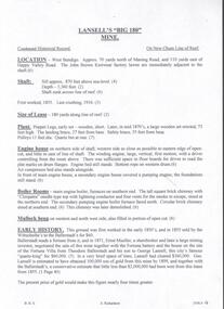
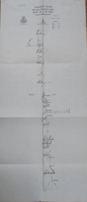
Plan - Confidence Extended Co, Unknown
... Transverse section of mine shaft, annotated with geological features and depths. Plan forms part of the Margaret Roberts Collection....Transverse section of mine shaft, annotated with geological features and depths. Plan forms part of the Margaret Roberts Collection. ...The Confidence Extended Gold Mine was located near the corner of Taylor Street and Upper California Road, Long Gully. CONFIDENCE EXTENDED This company, as will be soon by the plan, has a large lease holding on the extension of the line. The main shaft, which is in a fairly central position, is down about 2350 ft., while the lowest level at the N. shaft is at 1403ft. After making- allowances for the northerly pitch of the country, it is calculated that the main shaft would require to be deepened about 600ft. in order to pick lip the continuation of the reef being opened up successfully in the "Windmill Hill mine. 'Bendigo Advertiser' 7th May 1909.Printed in black text on top of plan: 'Confidence Extended Co'. Handwritten name inscribed: 'N.Cundy, 8.2.10'. Transverse section of mine shaft, annotated with geological features and depths. Plan forms part of the Margaret Roberts Collection.gold mining, gold, bendigo, transverse section, confidence extended gold mine