Showing 113 items matching shires
-
 Warrnambool and District Historical Society Inc.
Document - Ledger: Shire of Warrnambool Engineers Correspondence CRB 1933-1935, Circa 1930
A detailed continuum of correspondence showing the progress of development in the district and the co-operation and cost sharing between the different shires to have work completed.The correspondence contained within this book shows the link between the Shire Of Warrnambool and the Country Roads Board. Some letters provide costings of materials and plant and equipment and wages for workmen. Dark green cloth covers with fawn suede spine and corner binding. Navy Blue patterned paper inside front and back covers. Alphabetical index at the front. Pages 1-148 contain copies of correspondence .Remainder is not used. There is a typed foolscap sized sheet printed with work conditions, included loose at the rear of the book.On spine: Letter Book with CRB printed in black underneath. Country Roads Board 1933-193 vertically on leather spine at front.warrnambool, warrnambool shire council, country roads board, 1933-1935, j crawley, warrnambool shire engineer -
 Orbost & District Historical Society
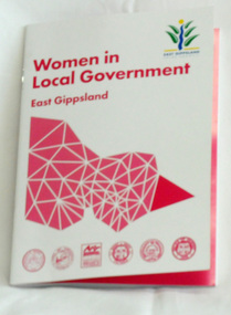
book, Women in Local government, 2015
This book was produced by East Gippsland Shire Council's Communication Unit - Janek Krause, Emma Langres and David Radford. It was supported by East Gippsland Historical society an Tim Gibson. This book celebrates the work of women in local government in East Gippsland. It is an excellent reference tool.A 42 pp stapled book titled, Women in Local Government. It is a collection of stories of women who have served as councillors in East Gippsland. The cover is white with magenta print,. In the top right corner is the East Gippsland Shire Council logo. In the centre is a stylised map of Victoria divided into shires with the East Gippsland shire highlighted.local-government east-gippsland women-in-government -
 Orbost & District Historical Society
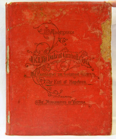
book, McCarron, Bird & Co, Addresses to H.R.H Duke of Cornwall and York, 1901
This book was published by the Municipal Association of Victoria to commemorate the inauguration of the Commonwealth of Australia in 1901. The addresses were made on the occasion of the Duke & Duchess of Cornwall & York's visit to Melbourne in May 1901. They were in the city for the opening of Federal Parliament which took place at the Exhibition Building in Carlton Gardens on 9 May 1901. .This item is associated with the history of the Federation of Australia and is a useful research tool.Hard-covered book, red cloth, with gold impressed lettering, containing 118 pages of illustrated copies of addresses to HRH Duke of Cornwall & York and His Excellency, Earl Hopetoun, the Governor General from the Shires of Victoria (includes Orbost). The addresses are surrounded by elaborate borders containing native flowers, particularly wattle. There are alsos cenes of rural Victoria. Incised on front cover - Addresses to H.R.H. Duke of Cornwall & York and his Excellency the Gov. General, the Earl of Hopetoun from the Municipalities of Victoria.federation duke-of-cornwall speeches-addresses -
 Greensborough Historical Society
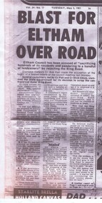
Newspaper - Newspaper Clipping (copy), Blast for Eltham over road, 05/05/1981
An early report of the dissention between Eltham and Diamond Valley shires over the proposed "outer ring road" and its possible extension through to Eltham. This was a precursor to the present day metropolitan ring road.News clipping, black text, slightly smudged copy..metropolitan ring road, shire of diamond valley, shire of eltham -
 Federation University Historical Collection
Book, Historic Sites Survey: North Central Study Area, 1979
The North Central Study Area included the Shires of Avoca, Bet Bet, east Loddon, Goulburn, Untly, Kara Kara, Korong, Maldon, Marong, Metcalfe, McIvor, Newstead, Strathfieldsaye, Stawell, Talbot, Clunes, Tullaroop and Waranga. 153 page book with white plastic binding. It is an historic sites survey for the North Central Study Area commissioned by the Land Conservation Council, the Ministry for COnservation and the Australian Heritage Commission. castlemaine, mount alexander goldfield, maldon, percydale, warrenmang, moliagul, tarnagulla, stuart mill, the whipstick, whroo, rushworth, graytown ironbark forest, st arnoaud, new bendigo, landsborough, inglewood, kurting, wedderburn, wehla, kooroora, langham flat, mcintyre, rheola, diamond hill, fosterville, coliban water works, green gully, newstead, muckleford forest, costerfield, graytown, bailieston, waranga irrigaiton system, eucalyptus distillery, mia mia bridge, korokubeal township researce, concegella slate quarry, chewton, fryerstown, kingower, timor, talbot, majorca, carisbroook, clunes, st arnaud, taradale, icomos, dunolly, limestone, castlemaine slate quarry, harcourt granite, taradale railway viaduct, loddon united waterworks trust, gouldburn weir, carisbrook lock-up, history of tree planting in streets, history of public reserves, r.u. nicholls nurseryman, thomas lang, francis moss, ballarat botanical gardens, ballarat school of mines botanical gardens, lake wendouree, victoria park, ballarat, muont holled smith, ballaarat old cemetery planting, eastern oval, ballarat east botanical gardens, ballarat east town hall gardens, eureka stockade reserve, ballarat observatory plantings, yarrowee creek plantings, yarrowee bluestone channels, ballarat woollen mill, band and albion mullock heap, black hill plantings, yarrowee creek channels, canadian creek channel, specimen vale channel, poverty point reserve, union jack reserve buninyong, imperial mine, buninyong, victoria street plantings, bridge mall, sturt street gardens, ballarat avenue of honour plantings, white flat oval plantings, camp street, elms, burnt creek -
 Bendigo Military Museum
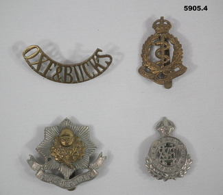
Badge - BADGES, BRITISH, C.1914 - 18 or pre
.1) Oxeford Shire & Buckingham Shires Light Infantry. .3) Cheshire Infantry Regiment. .4) 18th Royal Hussars Cavalry. Items in the collection re John D Gardiner No 2832, refer Cat No 5892.2 for his service details..1) Badge brass curved shape all lettering with two lugs on rear. .2) Badge pressed brass crown at top, wreath and Serpent, scroll at bottom, pin on rear. .3) Badge pressed brass, 8 sided star with central motif, scroll under with raised lettering, pin on rear. .4) Badge pressed silver colour, crown at top, central circle with raised lettering, wreath under and pin on rear..1) "OXE & BUCKS" .2) "Royal Army Medical Corp". .3) "CHESHIRE" .4) Queen Mary's Own". -
 Eltham District Historical Society Inc
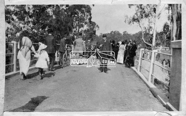
Photograph, Hurstbridge - Cr. Price crossing New Bridge (Opening Day), 1917
Eltham Shire Councillor Albert Price joined over 500 spectators for the official opening of the new re-inforced concrete bridge across the Diamond Creek at Hurstbridge. Eltham Shire shared the cost of the construction of the bridge with Heidelberg and Whittlesea Shires.This photo forms part of a collection of photographs gathered by the Shire of Eltham for their centenary project book, "Pioneers and Painters: 100 years of the Shire of Eltham" by Alan Marshall (1971). The collection of over 500 images is held in partnership between Eltham District Historical Society and Yarra Plenty Regional Library (Eltham Library) and is now formally known as 'The Shire of Eltham Pioneers Photograph Collection.' It is significant in being the first community sourced collection representing the places and people of the Shire's first one hundred years.Digital imagesepp, shire of eltham pioneers photograph collection, diamond creek, hurstbridge, wattle glen, bridge, councilor price, opening day, diamond creek (river) -
 Greensborough Historical Society
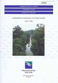
Pamphlet, Lower Plenty River concept plan, summary report: Maroondah Pipetrack to Yarra River, 1992_07
This draft concept plan covers the lower Plenty River from the Maroondah Pipe track in Greensborough to where the Plenty meets the Yarra. Melbourne Water was the lead agency, assisted by the Shires of Eltham and Diamond Valley, City of Heidelberg, the EPA and Department of Planning and Housing.Coloured pamphlet, photograph and plans 12 pages. 2 copies.plenty river, maroondah aqueduct, melbourne water -
Tatura Irrigation & Wartime Camps Museum
Book, Addresses to HRH Duke of Cornwall & York & his Excellency the Governor General, the Earl of Hopetoun. From the municipalities of Victoria, 1901
Copies were presented to each of the city and council shires. This copy presented to Cr James Harper by the then Shire President Cr Hogan. Picture work in sepia.James Harper's grand daughter agreed to the donation of this book 114 years after it was gifted to her grandfather.Hard cover with red cloth cover and gold writing. Contains insignia of every city and shire council in Victoria in 1901.Presented by Thomas Hogan Esq, JP President Shire of Rodney to his colleague Cr James Harper. at Tatura February 24th, 1902.federation, royalty, cr james harper, cr hogan -
 Rutherglen Historical Society
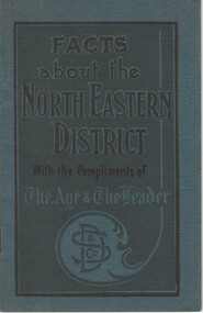
Booklet, David Syme & Co, Facts about the North Eastern District, With the Compliments of The Age & The Leader, c1928
Covers information on the districts and the leading towns of the north-east of Victoria, including Benalla, Rutherglen, Wodonga, Omeo, Euroa and Mansfield. Centre pages present statistics comparing 1928 to 1908, relating to agricultural production, and the population, dwellings and valuations of the shires of each of these towns.Small booklet with a dark blue-green cover, containing information about the North Eastern districts of Victoria.benalla, rutherglen, wodonga, omeo, euroa, mansfield, statistics -
 City of Greater Bendigo - Civic Collection
Administrative record - Land Sales, Department of Lands and Survey et al, 1929
This type of album was created by agents auctioning and selling land.Large portfolio style album with green cloth cover bound with three large metal pins. One hundred and then pages with thirty three Department of Lands and Survey maps pasted in. Index page. Maps have handwritten notes and markings throughout in pencil and pen. Covers the Counties of Bendigo, Rodney, Talbot, Gunbower, Gladstone, Tatchera and Karkarooc, Shires of East Loddon and Huntly and Swan Hill District. -
Clunes Museum
MUNICIPAL DIRECTORY 1888, ARNALL 7 JACKSON PRINTERS & STATIONERS 1888, 1888
THIS GAZETTEER CONTAINS INFORMATION ON VICRORIAN CITIES, TOWNS, BOROUGHS, SHIRES & VILLAGES, IN 1888, THE COUNCILLORS AND OFFICE BEARERS AND HISTORY OF EACH TOWN, SHIRE & BOROUGHS. POPULATION, AREA ANNUAL RATES, TRANSPORT & REVENUE, ALSO MEDICAL & POSTAL NOTES, ETC. CLUNES BOROUGH PAGE 137THE VICTORIAN MUNICIPAL DIRECTORY AND GAZETTEER FOR 1888.local history, document, municipal directory, history, shire -
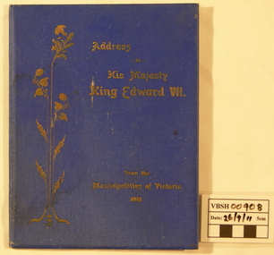 Ballan Shire Historical Society
Book - Book. Address to King Edward VII, McCarron Bird and Co, Address to His Majesty King Edward VII. from the Municipalities of Victoria 1901, 1901
The book contains the Joint Address to His Most Gracious Majesty King Edward the Seventh from the Municipalities of Victoria, and is dated Melbourne, 30th January 1901. It contains the Cities, Towns, Boroughs, and Shires with the signatures of the chief officers of each and signatures of the Executive and Executive Committee of the Municipal Association of Victoria.A thin hard cover book with a royal blue cover and gold leaf title title with an upright leaf embellishment on the left. Book No.108. 16 pages.With the compliments of the Executive Committee of the Municipal Association of Victoria.king edward v11, municipal association of victoria, royal visit 1901 -
Hume City Civic Collection
Document - Address, Address to His Majesty King Edward V11
This is a printed address to His Majesty King Edward V11 swearing allegiance to him and wishing him a long reign on behalf of the Municipalities of Victoria dated 30 January 1901. It has a cloth cover with gold print on the front and the inside pages have signatures from leaders of cities, towns, boroughs and shires. It was produced by the Municipalities of Victoria in 1901.A bound address with a blue cloth cover and gold print on the front to His Majesty King Edward V11.1900s, municipal association of victoria, starkie joseph, daniel john -
 Bendigo Military Museum
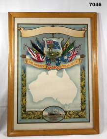
Certificate - CERTIFICATE, FRAMED, Goldsworthy & Davey Artists, WW1
Red print on Certificate template. "For Liberty ANZACs FOR JUSTICE". THIS IS A BLANK CERTIFICATE.Certificate - paper, red print on scroll, illustrated in colour - top to bottom, blank scroll; 2 soldiers and flag surrounded by 6 flags, silhouette in white of Australian map, oval shape with ship and troops. Further side decoration yellow and green wattle flowers and foliage. Pale blue background. Certificate template - possibly available to Shires and localities to customise as required. frame - timber, with varnish finish in natural tones, glass front and cardboard back.framed, ww1, certificate -
 Eltham District Historical Society Inc
Photograph - Digital Photograph, Alan King, Monash Bridge, Hurstbridge, 23 January 2008
Monash Bridge spans the Diamond Creek at Hurstbridge. It was built in 1917 for the Shires of Heidelberg, Eltham and Whittlesea. It is considered Nillumbik Shire's finest engineered bridge and was construced by the engineering company of Sir John Monash. Covered under Heritage Overlay, Nillumbik Planning Scheme. Published: Nillumbik Now and Then / Marguerite Marshall 2008; photographs Alan King with Marguerite Marshall.; p117This collection of almost 130 photos about places and people within the Shire of Nillumbik, an urban and rural municipality in Melbourne's north, contributes to an understanding of the history of the Shire. Published in 2008 immediately prior to the Black Saturday bushfires of February 7, 2009, it documents sites that were impacted, and in some cases destroyed by the fires. It includes photographs taken especially for the publication, creating a unique time capsule representing the Shire in the early 21st century. It remains the most recent comprehenesive publication devoted to the Shire's history connecting local residents to the past. nillumbik now and then (marshall-king) collection, hurstbridge, monash bridge -
 Eltham District Historical Society Inc
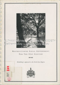
Document (Item) - Book, City of Heidelberg, Restructuring Local Government for the 21st Century: Heidelberg's approach to the North East Region, February 1994
The City of Heidelberg's Council first preference is "no change" [to municipal restructure] but if this option is unacceptable, the Council would prefer to form larger municipality/municapilites involving the exisitng City of Heidelberg and the Shires of Diamond Valley and Eltham. This report includes an exective summary, Introduction, A Brief History, Heidelberg and its [municiapl] neighbours now, opportunities for restructure, detailed analysis and preferred structure. Includes fold out maps.This report by the City of Heidleberg is a significant local contribution in the consultation leading to a significant change to local government in Victorian when, in 1994 the Kennett State government restructed local government. The reforms dissolved 201 Councils and created 78 new councils through amalgamations. In suburban Melbourne 53 municipalities were reduced to 26. The City of Heidelberg was amalgamated with parts of the Shire of Eltham and Diamond Valley to become the City of Banyule.annexation, council amalgamation, local government -
 Phillip Island Conservation Society Inc.
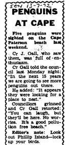
Work on paper - Photocopy of newspaper cutting, Wonthaggi Sentinel, or South Gippsland Sentinel Times, "PENGUINS/AT CAPE"
Cr J Gall was a councilor on the Borough of Wonthaggi Council. The Borough included Cape Paterson, where Cr Gall saw 5 little penguins on the beach. He described them as looking for somewhere to nest – that is, to dig burrows in the coast adjoining the Cape Paterson sandy beach. At that stage, the Wonthaggi state coal mine had been closed for 4 years and Wonthaggi had more emphasis on attracting different industries. There was little interest in flora and fauna of the area at that stage. Cr Gall’s unusual sighting of the Little Penguins possibly nesting at Cape Paterson attracted derision from the other councillors, and also a sarcastic Editor's Note from the newspaper's editor - none of which was not surprising for that era. The Borough of Wonthaggi was later amalgamated with the shires of Phillip Island and Bass, plus other areas of a couple of others local shires in 1994 to form Bass Coast Shire Council, which quickly moved to a heavy emphasis on flora, fauna and the tourism industry related to the environment generally.The article clearly demonstrates the disinterested if not dismissive attitude of the Borough of Wonthaggi councillors and the local newspaper editor at the time towards observations of flora and fauna. However, the article is also an interesting record of 5 Little Penguins being sighted at a beach where they were not known to have previously been seen.Photocopy of Single column newspaper article, black print on white paper. Article has curved line border design on top, sides. Cut off in copy at bottom edge. Five paragraphs in main article, and 1 paragraph at bottom marked: Editor's noteSEN 13 - 7 - 72 (South Gippsland Sentinel Times newspaper, 13th July, 1972)little penguins, fairy penguins, eudyptula minor, penguin behaviour, borough of wonthaggi, cr j gall -
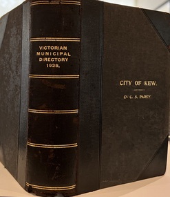 Kew Historical Society Inc
Journal, Arnall & Jackson: Printers & Stationers, Victorian Municipal Directory and Gazetteer : Also Commonwealth Guide and the Water Supply Record for 1928
The Victorian Municipal Directory provided annual details, and later bi-annual details, of all councils. Published by Arnall & Jackson (Printers and Stationers), copies were published in 'cloth' for sixteen shillings and 'half roan' for eighteen shillings. This copy was owned by Cr C.S.Parry. Elected to the Kew City Council as a representative of North Ward, Cr Parry was elevated to the position of Mayor in 1931. It, together with five other editions, was presented to the Kew Historical Society in 1987 by his grandson.Bound copy of the Victorian Municipal Directory and Gazetteer: Also Commonwealth Guide and the Water Supply Record for 1928. The volume contains 846 pages and includes sections on: - Comparative table – Municipal Returns for Twenty-one Years. - Index to Townships, Parishes and Railway Stations. - Changes and appointments. - Commonwealth of Australia (Constitution, Parliament, Departments and Officers). - State of Victoria (Parliament, Departments and Officers / Boards, Institutions, Trusts and Loans). - Municipalities in Victoria (Cities and Towns, Boroughs, Shires). - Water Supply (State Rivers and Water Supply Commission).non-fictionThe Victorian Municipal Directory provided annual details, and later bi-annual details, of all councils. Published by Arnall & Jackson (Printers and Stationers), copies were published in 'cloth' for sixteen shillings and 'half roan' for eighteen shillings. This copy was owned by Cr C.S.Parry. Elected to the Kew City Council as a representative of North Ward, Cr Parry was elevated to the position of Mayor in 1931. It, together with five other editions, was presented to the Kew Historical Society in 1987 by his grandson. victoria -- registers -- periodicals., victoria -- directories., water-supply -- victoria -- directories., municipal government -- victoria -- periodicals., cities and towns -- victoria -- directories. -
 Warrnambool and District Historical Society Inc.
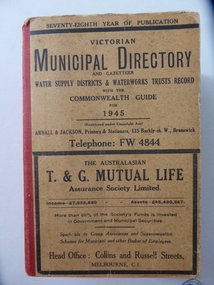
Stamp, W'bool Co.op Commons Seal, 1945
This is a Victorian Municipal Directory for 1945, containing general information on all municipalities in Victoria, a Gazeteer, a Commonwealth Guide and a Water Supply Record. Municipal Directories were published annually in Victoria from 1867 on. This directory came from the Shire of Mortlake which was established in 1864 when it had an area of 2137 square kilometres. The Shire of Mortlake was abolished in 1994 and merged with other neighbouring shires to form the present day Shire of Moyne. This book is very useful to researchers as it contains much information on the City, Borough and Shire structures, the Council employees and Government employees of all the municipalities. It has, therefore, important local information on Warrnambool and the surrounding areas in 1945. This is a soft cover book of 1114 pages. It has a buff- coloured cover with red binding on the spine. The printed material on the covers is printed in black. It has a blue stamp of the Shire of Mortlake on several pages. The book contains several advertisements for Melbourne businesses. ‘Shire of Mortlake’ shire of mortlake, local government in victoria, warrnambool history -
 Orbost & District Historical Society
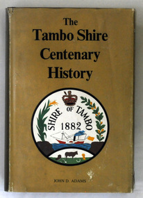
book, James Yeates & Sons, The Tambo Shire Centenary History, 1981
This is a local history of the Tambo Shire in East Gippsland. Tambo Shire (1882-1994) was created on 6 January 1882, by severance from Bairnsdale shire with Bruthen as the head . It was named after the Tambo River. Orbost Shire was originally a part of this shire as was Lakes Entrance. In 1994 Tambo shire was united with Bairnsdale city, Orbost and Omeo shires, most of Bairnsdale shire and part of Rosedale shire to form East Gippsland Shire.This book is a useful reference book on the history of the Tambo district.A 448 pp book with a gold coloured dust jacket with black print and an illustration of the Tambo Shire emblem 1882. It is titled " The Tambo Shire Centenary History".tambo-shire-history -
 City of Whittlesea
Literary work - Manuscript - S. T. Grey, The History of the Formation of the Shire of Whittlesea, S.T. Grey, 1961
The History of the Formation of the Shire of Whittlesea chronicles the establishment of the Darebin, Epping, Morang, Merriang and Whittlesea road districts and shires, and their eventual formation into the Shire of Whittlesea. It also includes stories about early pioneers, local institutions, buildings and a brief account of the development of local government in Victoria. The history was compiled at the direction of the Shire of Whittlesea in 1961, by Mr. S.T.Grey. Several of the items in the manuscript were published as articles in the Whittlesea Post in 1961.Manuscript, paper, carbon copied typed text -
Eltham District Historical Society Inc
Document - Folder, Naughton, Tracey
Tracey Naughton was Eltham's Community Arts Officer. Contents Newspaper article: "Bringing the art community together", Diamond Valley News, 9 September 1986. Report of luncheon organised by Shire of Eltham's Community Services, speaker Tracey Naughton. Newspaper article: "Councils agree on merger decision", Diamond Valley News, 9 September 1986. Report on State government decision not to force merger of Eltham and Diamond Valley Shires.Newspaper clippings, A4 photocopies, etctracey naughton, community arts officer eltham, bob manuel, eltham shire, diamond valley shire, bob picone -
 Eltham District Historical Society Inc
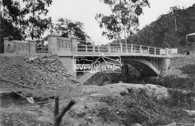
Negative - Photograph, New bridge at Hurstbridge, 1917
The newly constructed re-inforced concrete arched bridge across the Diamond Creek at Hurstbridge designed by John Monash. Eltham Shire shared the cost of the construction of the bridge with Heidelberg and Whittlesea Shires. The bridge was officially opened on 3rd November 1917. Part of a slide show presentation "Bridges & Waterways of the Shire" by Russell Yeoman to the 13 September 1989 Society meeting. The presentation included slides of historic photos from the Shire of Eltham Pioneers collections as well as several recent views.This photo forms part of a collection of photographs gathered by the Shire of Eltham for their centenary project book, "Pioneers and Painters: 100 years of the Shire of Eltham" by Alan Marshall (1971). The collection of over 500 images is held in partnership between Eltham District Historical Society and Yarra Plenty Regional Library (Eltham Library) and is now formally known as 'The Shire of Eltham Pioneers Photograph Collection.' It is significant in being the first community sourced collection representing the places and people of the Shire's first one hundred years.Digital image 4 x 5 inch B&W Negshire of eltham pioneers photograph collection, hurstbridge, bridge, 1917, diamond creek (creek), monash bridge -
 Eltham District Historical Society Inc
Newsletter, Eltham District Historical Society, Newsletter, No. 244 February 2019
Contents: • A Playful History by Jim Connor • Our February Meeting • March Excursion – Return to Research • You May Notice • Early Days Recalled At Eltham (Eltham and Whittlesea Shires Advertiser, 21 Nov 1941, p4) • Montmorency Press association – 1927 (Advertiser, 12 Aug 1927, p4) • An Eltham Road (The Argus, 27 Jul 1911, p5) • An Eltham Old resident (Advertiser, 19 Aug 1932, p6) • Eltham Cemetery Stories by Richard Pinn • Contacts for the Eltham District Historical Society The Shire of Eltham Historical Society was formed in October 1967. The first newsletter of the Society was issued May 1978 and has been published continuously ever since on a bi-monthly basis. With the cessation of the Shire of Eltham in late 1994, the Society's name was revised to Eltham District Historical Society and this name first appeared with issue No. 103, July 1995. The collection of the Society's newsletters provides a valuable resource on the history of the Society's activities, office bearers and committee members, guest speakers and subjects of historical interest pertinent to the former Shire of Eltham and the Eltham District.A4 newsletter distributed to membersnewsletter, eltham district historical society -
Glen Eira Historical Society
Book - Local Government Act First Report of the Assistant Commissioner of Roads and Bridges
This file contains 1 item: 1/The Local Government Act, First Report of the Assistant Commissioner of Roads and Bridges, printed by order of the Victorian Legislative Assembly on 08/03/1865. The document is the first annual report of John Steavenson, Assistant Commissioner of Roads and Bridges under s330 of the Local Government Act no. 176 (1863), and relates to transactions which took place from 02/09/1863 to 31/12/1864. The report outlines operations carried out by the Department of Roads and Bridges in this period. In the Glen Eira area this includes: separating electoral subdivisions of single districts (Moorabbin), adding detached portions of territory to road districts and shires (Caulfield), appointing of and altering in polling places, appointing of polling places for ridings of shires and subdivisions of road districts (Moorabbin), preparing and transmitting of forms of books also of pro forma accounts for guidance of local bodies in keeping their accounts, appointment of main roads, construction of a main road, ‘Dandenong’, in the Caulfield and Gardiner districts, proclaiming of Common Toll Roads, names of and security given by Managers of Common Toll Roads. The report also gives some information about the Shire of Caulfield, which contained 24 road districts and 340 rate payers in 8¼ square miles, and the Shire of Moorabbin, which contained 62 road districts and 713 rate payers in 30 square miles.local government act, assistant commissioner of roads and bridges, legislative council, caulfield historical soceity, steavenson john, sullivan j. f. the honourable, caulfield, moorabbin, road districts, point nepean road, nepean highway, dandenong road, princes highway, brown edwin, osher joseph, cosgrove john, ferres john, roads and bridges offices, caulfield roads district, moorabbin roads district, road construction and maintenance, roads and streets, acts of parliament -
 Stawell Historical Society Inc
Photograph, Stawell Shire Hall 1866
This photograph is a copy obtained from State Library of Victoria. The photograph is of Stawell Shire Hall. Two persons can be seen in the foreground. The two story brick building beside the Stawell Shire Hall was once the Literary Institute. The Stawell Shire Hall building has been added to over the years. Ronald Campbell, the Shires second president laid the foundation stone on 28th April. 1866. The contractors were Hutchings and Delbridge. The photograph shows the first hall and office. The building contained simple 18 feet square rooms, with an entrance hall separating them, the facade was almost as it is now. The initial cost of the Shire Hall was $502.Black and white photograph of Stawell Shire Hall as one single storey brick building with parapet on top. Beside the Shire Hall is a two storey brick building. Also, a dwelling between the two building in the background in Cooper St. Two persons in the foreground, one on the road the other on the pathway. stawell -
 Eltham District Historical Society Inc
Audio Recording, Audio Recording; 2016-10-12 History of Community Groups, 12 Oct 2016
October Meeting (Newsletter No. 230, Jun. 2016) Community groups are the backbone of any community and the former Shires of Eltham and now Nillumbik are no exception. In our area there are some groups with a long history of consistently contributing to the development, enrichment and benefit of our local communities. Some we are well aware of, others not so much. At our next meeting we are pleased to have representatives from three long established community groups to talk to us about their histories, how they have been a part of the Eltham scene for many years and how their contributions have supported many other local organisations and initiatives.1:03:34 duration Digital MP3 File 75 MB audio recording, community groups, eltham district historical society, meeting, society meeting -
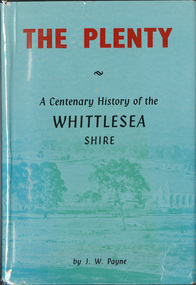 Eltham District Historical Society Inc
Book, J. W. Payne, The Plenty: A Centenary History of the Whittlesea Shire, 1975
This book traces the one hundered years of the development of the Shire of Whittlesea, from the discovery by Hume and Hovell in 1824 to the time of the centenary in 1975. The intervening years saw the settlement of Vandemonians, Sydney-siders, English, Scots, Irish and Germans, Black Thursday, the building of the Yan Yean Reservoir, the Plenty River flour millls, the timber industry, fruit-growing and export and vineyards. Personalities and pubs, subdivisions, stories of the Findon Hunt Club and various Shires including Epping. History of education and transiton from rural to urban in the south of the Shire. The work is illustrated with maps and photographs. The Shire is now the City of Whittlesea and is an immediate neighbour to the north of the Shire of Nillumbik. shire of whittlesea -
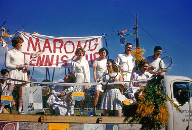 Bendigo Historical Society Inc.
Slide - Back to Marong Celebrations, c1960-1963
Marong was first incorporated as a road district on 27 August 1861, and became a shire on 23 December 1864. On 1 October 1915, the Borough of Raywood, which was gazetted on 17 January 1865 on 23.31 square kilometres (9.00 sq mi) of land 28 kilometres (17 mi) north of Bendigo,[2] was united with Marong. On 1 October 1990, the Shire of Marong became a rural city, under the Local Government Act 1989. On 7 April 1994, the Rural City of Marong was abolished, and along with the City of Bendigo, the Borough of Eaglehawk and the Shires of Huntly and Strathfieldsaye, was merged into the newly created City of Greater BendigoTwelve slides taken for the Back to Marong celebration about 1960-63 possibly at the Marong Recreation (Football) ground. Slides include a float with members of the marong tennis club, a family group, a float depicting old school days, horse and carts, ladies and men dressed in period costumes and Miss 'Golden North'.history, bendigo, back to marong, city of greater bendigo, rural city of marong, marong tennis club, carl tracey collection