Showing 33 items matching "solomon west"
-
 Phillip Island and District Historical Society Inc.
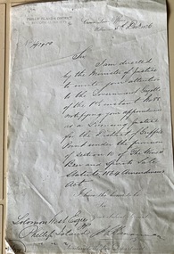
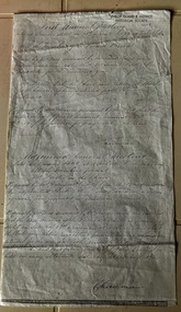
Document, Appointment of Solomon West as a Licensing Justice for the District of Griffith Point.1876
... Appointment of Solomon West as a Licensing Justice for the District of Griffith Point.1876......Solomon West...Solomon West and his brother John were pioneer settlers on Phillip Island. ...Solomon West Esq Phillip Island....Historical legal document Solomon West Lifestyle Solomon West Esq Phillip Island. ...Solomon West and his brother John were pioneer settlers on Phillip Island. Solomon was also a local councillor.HistoricalFoolscap photocopy of a handwritten letter from The Crown Law Office to Solomom West Esq.stating his appointment as a Licensing Justice for Griffith Point. 5 Dec 1876Solomon West Esq Phillip Island.legal document, solomon west, lifestyle -
 Phillip Island and District Historical Society Inc.
Photograph, 11/1983
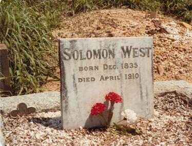
... solomon west...Buried at Bendigo in the Baptest Section E1 No. 20661, Quarry Hill, Bendigo, Victoria. Solomon West - 75 years....Colour photograph of the Gravestone for Solomon West - born Dec. 1835, died April 1910. ...Buried at Bendigo in the Baptest Section E1 No. 20661, Quarry Hill, Bendigo, Victoria. Solomon West - 75 years. solomon west pioneer solomon west w a mcleod Colour photograph of the Gravestone for Solomon West - born Dec. 1835, died April 1910. ...Former resident of Phillip Island. Arrived in Australia 1844. Buried at Bendigo in the Baptest Section E1 No. 20661, Quarry Hill, Bendigo, Victoria. Solomon West - 75 years.Colour photograph of the Gravestone for Solomon West - born Dec. 1835, died April 1910. Baptist Section at Bendigo Cemetery.solomon west, pioneer solomon west, w a mcleod -
 Phillip Island and District Historical Society Inc.
Photograph, Bryant West
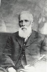
... ...solomon west...Photograph of Solomon West seated and wearing single breasted suit with waist coat, fob chain and holding walking stick....Phillip Island and District Historical Society Inc. phillip-island-and-the-bass-coast One of a collection of over 400 photographs in an album commenced in 1960 and presented to the Phillip Island & Westernport Historical Society by the Shire of Phillip Island local history photography photographs pioneer solomon west pioneers solomon west john jenner bryant west Photograph of Solomon West seated and wearing single breasted suit with waist coat, fob chain and holding walking stick. ...One of a collection of over 400 photographs in an album commenced in 1960 and presented to the Phillip Island & Westernport Historical Society by the Shire of Phillip IslandPhotograph of Solomon West seated and wearing single breasted suit with waist coat, fob chain and holding walking stick.local history, photography, photographs, pioneer solomon west, pioneers, solomon west, john jenner, bryant west -
 Phillip Island and District Historical Society Inc.
Photograph, Family Photographs and Back to Phillip Island
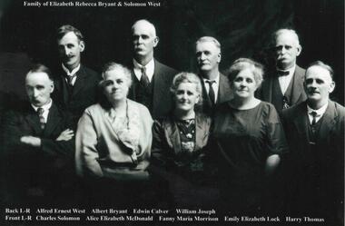
... West...Back to Phillip Island c1924...Morrison Family...Bryant...Solomon...1041-01 Family of Elizabeth Rebecca Bryant & Solomon West - family identified c1924 - ?? 1926 1041-02 Back to Phillip Island c 1924. ...1041-01 Photograph: Family of Elizabeth Rebecca Bryant & Solomon West 1041-02 Photograph: Back to Phillip Island c 1924 with names...Miriam West Henderson d/o John 3. ? 4. Emily West Lock d/o Solomon 5. ? 6. Fanny West Morrison w/o No. 6 above, d/o Solomon 7. ...Phillip Island and District Historical Society Inc. phillip-island-and-the-bass-coast 1041-01 Family of Elizabeth Rebecca Bryant & Solomon West - family identified c1924 - ?? 1926 1041-02 Back to Phillip Island c 1924. ...1041-01 Family of Elizabeth Rebecca Bryant & Solomon West - family identified c1924 - ?? 1926 1041-02 Back to Phillip Island c 1924. People identified in 1989 by Mrs Beth Freeman, daughter of William Otway MorrisonHistorical1041-01 Photograph: Family of Elizabeth Rebecca Bryant & Solomon West 1041-02 Photograph: Back to Phillip Island c 1924 with names1041-01: Family of Elizabeth Rebecca Bryant & Solomon West Back L-R Alfred Ernest West, Albert Bryant, Edwin Calver, William Joseph Front L-R Charles Solomon, Alice Elizabeth McDonald, Fanny Maria Morrison, Emily Elizabeth Lock, Harry Thomas 1041-02: Back to Phillip Island c.1924 Identification 1989, Mrs Beth Freeman daughter of William Otway Morrison Front L-R 1. Dan Morrison 2. Ted West 3. Norman McDonald 4. William West s/o Solomon 5. ? 6. William Otway Morrison Second Row L-R 1.? 2. Miriam West Henderson d/o John 3. ? 4. Emily West Lock d/o Solomon 5. ? 6. Fanny West Morrison w/o No. 6 above, d/o Solomon 7. Child to 10 (man with pipe) not identified Back Row L-R 1 to 5 not identified 6. Albert West, s/o Solomon 7. Marion Somerville West 8. Janet Morrison w/o Wm West (obscured) 9. Harry Brown 10. Nell West Brown d/o William West 11-13 unidentified 14. Alice West McDonald d/o Solomon 15. Jenny?west, back to phillip island c1924, morrison family, bryant, solomon -
 Phillip Island and District Historical Society Inc.
Photographs, West Family, 2004
... A collection of 3 photographs with a page of notes on the West family. Solomon West and his brother John became pioneer settlers on Phillip Island. ...355-01: Coloured photograph of the grave and headston of Solomon West in the Bendigo Cemetry. 355-02: Coloured photograph of the headstone of Archie S. ...355-01: On the headstone: Solomon West Born Dec 1835 Died April 1910. 355-02: On the headstone: In loving memory of our beloved son Archie S West, accidentally killed Dec. 7 1911. ...Phillip Island and District Historical Society Inc. phillip-island-and-the-bass-coast A collection of 3 photographs with a page of notes on the West family. Solomon West and his brother John became pioneer settlers on Phillip Island. ...A collection of 3 photographs with a page of notes on the West family. Solomon West and his brother John became pioneer settlers on Phillip Island. Solomon married Elizabeth Bryant in 1857 at St Andres Church of England, Brighton. Elizabeth died in 1895 on Phillip island and is buried in the Phillip Island cemetery. Archie was the son of William and Jane West who died tragically in the Bendigo rail yards at the age of 21. Jane was buried in the same grave in Bendigo. Nellie, William and Jane's 2nd child married Harry Alexander Brown and are buried in the same grave together with Nellie's father, William West.355-01: Coloured photograph of the grave and headston of Solomon West in the Bendigo Cemetry. 355-02: Coloured photograph of the headstone of Archie S. West and Janet West in the Bendigo Cemetry. 355-03: Coloured photograph of the headstone of Nellie Brown, Harry Brown and William West in the Bendigo Cemetry. 355-04: A4 sheets of notes written by Alan West in May 2004 describing the above three photographs and the West family.355-01: On the headstone: Solomon West Born Dec 1835 Died April 1910. 355-02: On the headstone: In loving memory of our beloved son Archie S West, accidentally killed Dec. 7 1911. Aged 21 years. Only "Good Night, Beloved" not "Farewell". Also his mother Janet West. Died July 30, 1938 Aged 79 years. 355-03: On the headstone: In memory of Nellie Elizabeth Brown died Jan 4 1971. Also her husband Harry Alexander Brown and he father William West.the west family phillip island, alan west, bendigo cemetry -
 Phillip Island and District Historical Society Inc.
Document, First Annual Meeting minutes of Roads Board 1871
... ...Solomon West...Historical Local government Roads board Solomon West James Forster John Houston First annual meeting held at Bauer's hotel on 15 November 1871at 12 o'clock Foolscap photocopy of handwritten minutes of the first annual meeting of the Roads Board, appointing Mr James Forster as Chairman. ...A Phillip Island Road Board was formed in 1871. It was absorbed by Phillip Island and Woolamai Shire in 1874.HistoricalFoolscap photocopy of handwritten minutes of the first annual meeting of the Roads Board, appointing Mr James Forster as Chairman. Also minutes of adjoined general meeting, held later the same day, appointing John Houston was Clerk and all meetings be held at Bauer's Hotel.First annual meeting held at Bauer's hotel on 15 November 1871at 12 o'clocklocal government, roads board, solomon west, james forster, john houston -
 Phillip Island and District Historical Society Inc.
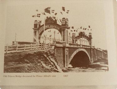
Photograph, 1867
... copied from book "Melbourne's Yesterday's" See Phillip Island Book re Solomon West etc. Nov. 1983...Phillip Island and District Historical Society Inc. phillip-island-and-the-bass-coast Old Princes Bridge - 1845. copied from book "Melbourne's Yesterday's" See Phillip Island Book re Solomon West etc. Nov. 1983 old princes bridge melbourne prince alfred's visit 1867 w a mcleod "Old Princes Bridge decorated for Prince Alfred's visit 1867" Sepia photograph of the old Princes Bridge Melbourne decorated for Prince Alfred's visit in 1867. ...Old Princes Bridge - 1845. copied from book "Melbourne's Yesterday's" See Phillip Island Book re Solomon West etc. Nov. 1983Sepia photograph of the old Princes Bridge Melbourne decorated for Prince Alfred's visit in 1867."Old Princes Bridge decorated for Prince Alfred's visit 1867"old princes bridge melbourne, prince alfred's visit 1867, w a mcleod -
 Phillip Island and District Historical Society Inc.
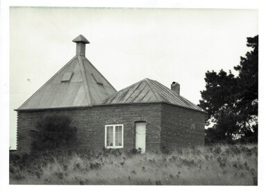
Photograph, Richardson's chicory kiln 1077-01
... In 1878, the first chicory kiln was built by Mr. John and Solomon West, in Thompson Avenue, Cowes, near the Esplanade and the second kiln was built in 1880 by Mr Joseph Richardson....Phillip Island and District Historical Society Inc. phillip-island-and-the-bass-coast In 1878, the first chicory kiln was built by Mr. John and Solomon West, in Thompson Avenue, Cowes, near the Esplanade and the second kiln was built in 1880 by Mr Joseph Richardson. ...In 1878, the first chicory kiln was built by Mr. John and Solomon West, in Thompson Avenue, Cowes, near the Esplanade and the second kiln was built in 1880 by Mr Joseph Richardson.HistoricalLarge black & white photo of a brick chicory kiln with a metal roof,door and window. In a paddock with large trees nearby.2nd chicory kiln on Phillip Island, now turned into a holiday house.chicory, chicory kilns, joseph richardson, -
 Phillip Island and District Historical Society Inc.
Photograph, 1978 - 79
... Cowes Post Office built in 1909 with handmade bricks which were first used in the building of first Chicory Kiln in Cowes on Phillip Island in 1870 by the West brothers, Solomon and John. It is now a Restaurant and Pizza outlet....Phillip Island and District Historical Society Inc. phillip-island-and-the-bass-coast Cowes Post Office built in 1909 with handmade bricks which were first used in the building of first Chicory Kiln in Cowes on Phillip Island in 1870 by the West brothers, Solomon and John. It is now a Restaurant and Pizza outlet. local history photographs buildings historic buildings - historical coloured photograph john cook phillip island Cowes old Post Office Large white building on the west corner of Thompson Avenue and The Esplanade, Cowes Photograph ...Cowes Post Office built in 1909 with handmade bricks which were first used in the building of first Chicory Kiln in Cowes on Phillip Island in 1870 by the West brothers, Solomon and John. It is now a Restaurant and Pizza outlet.Large white building on the west corner of Thompson Avenue and The Esplanade, Coweslocal history, photographs, buildings, historic, buildings - historical, coloured photograph, john cook, phillip island, cowes old post office -
 Sunshine and District Historical Society Incorporated
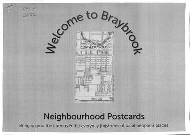
Document - Welcome to Neighbourhood Braybrook Postcards, History At Work Pty Ltd, 2021
... A walking tour map is included that allows one to visit the various points of interest featured in the postcards including The Munition Workers Housing Estate, The basalt plains of the west, Solomon's Ford, Quang Minh Temple, The animal by-products industry, Braybrook Radio Broadcasting Station, Peanut Butter Factory (ETA), Yvonne Barrett Australian Pop Singer, The Marin baluk, Melon Street, Doug Hawkins AFL Champion and Tottenham RAAF....A walking tour map is included that allows one to visit the various points of interest featured in the postcards including The Munition Workers Housing Estate, The basalt plains of the west, Solomon's Ford, Quang Minh Temple, The animal by-products industry, Braybrook Radio Broadcasting Station, Peanut Butter Factory (ETA), Yvonne Barrett Australian Pop Singer, The Marin baluk, Melon Street, Doug Hawkins AFL Champion and Tottenham RAAF. ...History at Work produced a number of Neighbourhood Postcards of various sites throughout Victoria. Neighbourhood Postcards probes the memories of our local streets for histories of local people whose lives, play, work and pre-occupation have shaped our local communities today. This set features Braybrook, a suburb of Shire of Braybrook and City of Sunshine, prior to the Council mergers in 1996, which created the City of Brimbank. A walking tour map is included that allows one to visit the various points of interest featured in the postcards including The Munition Workers Housing Estate, The basalt plains of the west, Solomon's Ford, Quang Minh Temple, The animal by-products industry, Braybrook Radio Broadcasting Station, Peanut Butter Factory (ETA), Yvonne Barrett Australian Pop Singer, The Marin baluk, Melon Street, Doug Hawkins AFL Champion and Tottenham RAAF.Welcome to Neighbourhood Braybrook Postcards Bringing you the curious & everyday history of local people and placesbraybrook, munition workers housing estate, solomon's ford, quang minh temple, braybrook radio broadcasting station, peanut butter factory, eta, yvonne barrett, marin baluk, melon street, doug hawkins, les twentyman, alfred ravenhall, raaf no 1 store, myalla street, braybrook salvation army hall, darnley street, kingsford street, carlton street, joseph solomon -
 Orbost & District Historical Society
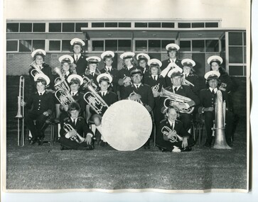
black and white photograph, December 1973
... Those in the photograph are: At Rear- Peter Fagg and Alan Miles; Back Row - Jacqueline Solomon' Cryatal Barling, Julie West, Raymond Barling, Maddy Barr' Peter Rowley, Luigi Battel, Michelle Zuccolo, Helen Light; Seated - Phillip Barling, Russell Jensen, Susan Wood, Alf Barling (Band Master), Edward Knight, Charles Soloman; In Front - Mark Barling and Peter Knight The first Orbost Brass Band was formed in 1889. ...Those in the photograph are: At Rear- Peter Fagg and Alan Miles; Back Row - Jacqueline Solomon' Cryatal Barling, Julie West, Raymond Barling, Maddy Barr' Peter Rowley, Luigi Battel, Michelle Zuccolo, Helen Light; Seated - Phillip Barling, Russell Jensen, Susan Wood, Alf Barling (Band Master), Edward Knight, Charles Soloman; In Front - Mark Barling and Peter Knight The first Orbost Brass Band was formed in 1889. ...This photograph of the Orbost Municipal Band was taken outside the Orbost Youth Centre in Nicholson Street, Orbost. Those in the photograph are: At Rear- Peter Fagg and Alan Miles; Back Row - Jacqueline Solomon' Cryatal Barling, Julie West, Raymond Barling, Maddy Barr' Peter Rowley, Luigi Battel, Michelle Zuccolo, Helen Light; Seated - Phillip Barling, Russell Jensen, Susan Wood, Alf Barling (Band Master), Edward Knight, Charles Soloman; In Front - Mark Barling and Peter Knight The first Orbost Brass Band was formed in 1889. Around 1908 the town band split and the Orbost Workers' Band was formed. Eventually the two bands merged in 1913 to reform as the Orbost Municipal Band under conductorship of Charles Spink. The band continued for many years but was later disbanded and again reformed. This was to happen a number of times, the last time being in 1961 and continuing through to the late 1970's. Further info and Ref: In Times Gone By - Deborah Hall This is a pictorial record of the Orbost Municipal Band. The various Orbost bands over the years played a major role in community activities providing entertainment and musical experiences for the many members.A large black / photograph of a group of uniformed band members standing and seated in rows outside a building. All are holding musical instruments. There is a drum in the centre front row.on back - label with list of namesmusic-orbost orbost-municipal-band entertainment recreation -
 Bendigo Military Museum
Map - RASvy " Map Makers Exhibition 2025 "- Map display, RAN Hydrographic Office, 1972 - 1992
... SOLOMON ISLANDS. MERCATOR PROJECTION. Used for the planning of RAAF flights. .6 RAAF AIR STAFF PLANNING CHART NS 137-1 DARWIN NORTH WEST. ...Current as at 30 Jun 92. .2 Extract of Navigational Plotting Chart " NP22-2 Tasmania " .3 Extract of Navigational Plotting Chart " NP 27 RAAF PLOTTING CHART AUSTRALIA - SOUTHEAST " .4 Extract of Navigational Plotting Chart " RAAF LONG RANGE PLOTTING CHART NP43-4 AUSTRALIA WESTERN " .5 Extract of Navigational Plotting Chart " RAAF LONG RANGE PLOTTING CHART NP43-7 SOLOMON ISLANDS " .6 Extract of Navigational Series " RAAF AIR STAFF PLANNING CHART NS 137-2 DARWIN NORTH WEST " .7 Extract of Navigational Series " RAAF AIR STAFF PLANNING CHART NS 137-1 DARWIN NORTH EAST " .8 Extract of Navigational Series " RAAF AIR STAFF PLANNING CHART NS 137-4 DARWIN SOUTH WEST " .9 Extract of Navigational Series " RAAF AIR STAFF PLANNING CHART NS 137-3 DARWIN SOUTH EAST " .10 Extract of Tactical Pilotage Chart " TPC R-13B " .11 Extract of Hydrographic Chart " PORT PHILLIP SOUTH and WEST CHANNELS " .12 Extract of Hydrographic Chart " GEELONG HARBOUR and APPROACHES " .13 Extract of En Route Chart " AUSTRALIA ERC HIGH " " H1 and H2 " ...SOLOMON ISLANDS. MERCATOR PROJECTION. Used for the planning of RAAF flights. .6 RAAF AIR STAFF PLANNING CHART NS 137-1 DARWIN NORTH WEST. ...All of these Charts / Maps were used for the RSL Museum display " The Mapmakers " ( of RASvy. ) 10 Jun - 10 Aug 2025. .1 Catalogue of Tactical Pilotage Charts, 1:500 000 Scale. Digital Data Base available as at 30Jun 92. This catalogue page shows the extent of the Australian area of responsibility for aeronautical charting. .2 RAAF PLOTTING CHART. NP 22-2 (Navigational Plotting) Tasmania. MERCATOR PROJECTION. This series of charts were used for the training of RAAF Navigators. These charts were produced and printed at the Army Survey Regiment, Bendigo. .3 RAAF PLOTTING CHART AUSTRALIA - SOUTHEAST. NP 27 is Based on LAMBERT CONFORMAL CONIC PROJECTION. This series of charts was used by RAAF Navigators for the planning of RAAF flights. These charts were produced and printed at the Army Survey Regiment, Bendigo. .4 RAAF LONG RANGE PLOTTING CHART. NP 43-4 AUSTRALIA WESTERN. MERCATOR PROJECTION. This series of maps were used for the planning of RAAF flights. Of Particular note these charts were used to plot "Rhumb Lines or loxodromes" where a course crosses all Meridians (Lines of latitude and longitude) at the same angle. On Mercator projection charts Rhumb lines are conveniently shown as straight lines and are also lines of constant compass bearing. Rhumb lines are usually longer than the shortest distance between two points. The shortest distance between two points on the earth's surface is called a "Great Circle Route" which is a route on a circular path on the surface of the earth where the centre of that circle is also the centre of the earth. Great Circle Routes on a Mercator Projection are however curves and harder to plot. These charts were produced and printed at the Army Survey Regiment, Bendigo. .5 RAAF LONG RANGE PLOTTING CHART. NP 43-7 SOLOMON ISLANDS. MERCATOR PROJECTION. Used for the planning of RAAF flights. .6 RAAF AIR STAFF PLANNING CHART NS 137-1 DARWIN NORTH WEST. AZIMUTHAL EQUIDISTANT PROJECTION. This series of charts were used for planning by the staff. The whole chart was produced by joining the four quadrant maps together. The charts are based on a single point of tangency (in this case Darwin) and shows radius (distance) in nautical miles to and from that point. A series of charts were produced centred on each of the major airfields in Northern Australia. These charts were produced and printed at the Army Survey Regiment, Bendigo. .7 RAAF AIR STAFF PLANNING CHART NS 137-2 DARWIN NORTH EAST. AZIMUTHAL EQUIDISTANT PROJECTION. Used for the planning by the staff. The charts are based on a point of tangency and show radius in nautical miles. .8 RAAF AIR STAFF PLANNING CHART NS 137-4 DARWIN SOUTH WEST. AZIMUTHAL EQUIDISTANT PROJECTION. Used for the planning by the staff. The charts are based on a point of tangency and show radius in nautical miles. .9 RAAF AIR STAFF PLANNING CHART NS 137-3 DARWIN SOUTH EAST. AZIMUTHAL EQUIDISTANT PROJECTION. Used for the planning by the staff. The charts are based on a point of tangency and show radius in nautical miles. .10 TACTICAL PILOTAGE CHART. TPC R-13B. LAMBERT CONFORMAL PROJECTION. Used by pilots for flight planning and could be used in flight if necessary for visual navigation using major ground features shown on the chart. These charts also contained aeronautical information such as airfields, radio navigation beacons and obstructions. Contours and height information was shown in feet to be compatible with aircraft altimeters. Each graticule square also contained a Maximum Safe Elevation Figure (MEF) also in feet. Coverage of this series over Australia's area of interest were produced and printed at the Army Survey Regiment, Bendigo. .11 HYDROGRAPHIC CHART. AUS 158. PORT PHILLIP SOUTH and WEST CHANNELS. PROJECTION TRANSVERSE MERCATOR. Used by all people needing to navigate a vessel. Hydrographic charts were printed at the Army Survey Regiment, Bendigo. .12 HYDROGRAPHIC CHART. AUS 157. GEELONG HARBOUR and APPROACHES. PROJECTION TRANSVERSE MERCATOR. Used by all people needing to navigate a vessel. .13 EN ROUTE CHART. AUSTRALIA ERC HIGH. H1 and H2. LAMBERT CONFORMAL CONIC PROJECTION. This series of charts were regularly produced by the RAAF Aeronautical Information Service (AIS) and contained current aeronautical information for pilots. These charts were printed at the Army Survey Regiment, Bendigo..1 Tactical Pilotage Chart Series Catalogue. Current as at 30 Jun 92. .2 Extract of Navigational Plotting Chart " NP22-2 Tasmania " .3 Extract of Navigational Plotting Chart " NP 27 RAAF PLOTTING CHART AUSTRALIA - SOUTHEAST " .4 Extract of Navigational Plotting Chart " RAAF LONG RANGE PLOTTING CHART NP43-4 AUSTRALIA WESTERN " .5 Extract of Navigational Plotting Chart " RAAF LONG RANGE PLOTTING CHART NP43-7 SOLOMON ISLANDS " .6 Extract of Navigational Series " RAAF AIR STAFF PLANNING CHART NS 137-2 DARWIN NORTH WEST " .7 Extract of Navigational Series " RAAF AIR STAFF PLANNING CHART NS 137-1 DARWIN NORTH EAST " .8 Extract of Navigational Series " RAAF AIR STAFF PLANNING CHART NS 137-4 DARWIN SOUTH WEST " .9 Extract of Navigational Series " RAAF AIR STAFF PLANNING CHART NS 137-3 DARWIN SOUTH EAST " .10 Extract of Tactical Pilotage Chart " TPC R-13B " .11 Extract of Hydrographic Chart " PORT PHILLIP SOUTH and WEST CHANNELS " .12 Extract of Hydrographic Chart " GEELONG HARBOUR and APPROACHES " .13 Extract of En Route Chart " AUSTRALIA ERC HIGH " " H1 and H2 " royal australian survey corps, rasvy, fortuna, detachment - army survey regiment, army svy regt, asr -
 Bendigo Military Museum
Photograph - PHOTOGRAPHS, CHRISTMAS / NEW YEAR CARD, C. WW1, c.WW2
... .1) Black & white photo, copy, Air Force, BILL WEST on back. .2) Black & white photo, original, cannon in park setting. .3) Black & white, photocopy, RALPH BELL (Spinner) on back. .4) Sepia photo, original, RALPH BELL & Jean .5) Sepia photo, original, RALPH BELL, Bendigo Milk Co on back, inside sprig of flowers, Greetings to McKenzie Family from Ralph Bell. .6) Xmas / New Year card, cover: Photo of Solomons Pools. .7) Sepia, photocopy, soldier in uniform, ERNIE DOWER. .8) Black & white photo, soldier in uniform, ERNIE DOWER....Bendigo Military Museum 37 - 39 Pall Mall Bendigo goldfields photography-photographs military history - air force - army .1) BILL WEST on back. .3) RALPH BELL (Spinner) on back. .5) RALPH BELL, Bendigo Milk Co on back, inside sprig of flowers, Greetings to McKenzie Family from Ralph Bell. .1) Black & white photo, copy, Air Force, BILL WEST on back. .2) Black & white photo, original, cannon in park setting. .3) Black & white, photocopy, RALPH BELL (Spinner) on back. .4) Sepia photo, original, RALPH BELL & Jean .5) Sepia photo, original, RALPH BELL, Bendigo Milk Co on back, inside sprig of flowers, Greetings to McKenzie Family from Ralph Bell. .6) Xmas / New Year card, cover: Photo of Solomons Pools. .7) Sepia, photocopy, soldier in uniform, ERNIE DOWER. .8) Black & white photo, soldier in uniform, ERNIE DOWER. ....1) Black & white photo, copy, Air Force, BILL WEST on back. .2) Black & white photo, original, cannon in park setting. .3) Black & white, photocopy, RALPH BELL (Spinner) on back. .4) Sepia photo, original, RALPH BELL & Jean .5) Sepia photo, original, RALPH BELL, Bendigo Milk Co on back, inside sprig of flowers, Greetings to McKenzie Family from Ralph Bell. .6) Xmas / New Year card, cover: Photo of Solomons Pools. .7) Sepia, photocopy, soldier in uniform, ERNIE DOWER. .8) Black & white photo, soldier in uniform, ERNIE DOWER..1) BILL WEST on back. .3) RALPH BELL (Spinner) on back. .5) RALPH BELL, Bendigo Milk Co on back, inside sprig of flowers, Greetings to McKenzie Family from Ralph Bell.photography-photographs, military history - air force - army -
 Phillip Island and District Historical Society Inc.
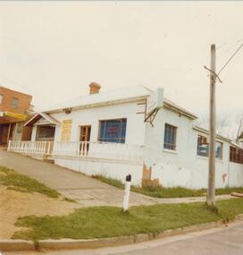
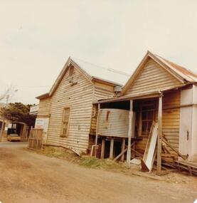
Photograph, 1978/79
... West bought Lot 1 for £45 . In the 1870's he built the first Chicory Kiln on Phillip Island. With his brother, Solomon, he started the General Store next to the Chicory Kiln in Thompson Avenue. ...West bought Lot 1 for £45 . In the 1870's he built the first Chicory Kiln on Phillip Island. With his brother, Solomon, he started the General Store next to the Chicory Kiln in Thompson Avenue. ...January 1869 at the first land sale in Cowes, John West bought Lot 1 for £45 . In the 1870's he built the first Chicory Kiln on Phillip Island. With his brother, Solomon, he started the General Store next to the Chicory Kiln in Thompson Avenue. Over the years the original building was extended and altered.Photograph of remains of West's store, Cowes. Timber building with corrugated roofing. Old iron water tank in front of building.local history, photographs, buildings, historic, buildings - historical, sepia photograph, john cook, phillip island, west's general store -
 Monbulk RSL Sub Branch
Book, Tess Press, an imprint of Black Dog & Leventhal Publishers, Inc, World War II album : the complete chronicle of the world's greatest conflict, 2002
... Monbulk RSL Sub Branch 48 Main Road Monbulk yarra-valley-and-the-dandenong-ranges World War 1939-1945 - Pictorial works World War 1939-1945 - History World War II Album presents a simultaneous documentary view of every theater of the war, from the steppes of Russia to the jungles of Malaysia and the Solomons; from the freezing cold of the northernmost fjords to the scorching sands of the Libyan desert; from the bunkers of the West Wall to the boundless oceans. ...World War II Album presents a simultaneous documentary view of every theater of the war, from the steppes of Russia to the jungles of Malaysia and the Solomons; from the freezing cold of the northernmost fjords to the scorching sands of the Libyan desert; from the bunkers of the West Wall to the boundless oceans.Index, ill, maps, p.740.non-fictionWorld War II Album presents a simultaneous documentary view of every theater of the war, from the steppes of Russia to the jungles of Malaysia and the Solomons; from the freezing cold of the northernmost fjords to the scorching sands of the Libyan desert; from the bunkers of the West Wall to the boundless oceans.world war 1939-1945 - pictorial works, world war 1939-1945 - history -
 Monbulk RSL Sub Branch
Book, Richard Tregaskis, Guadalcanal diary, 1943
... West Pacific...Guadalcanal - Battle of - Solomon islands...Monbulk RSL Sub Branch 48 Main Road Monbulk yarra-valley-and-the-dandenong-ranges World war 1939 – 1945 – Campaigns – South West Pacific Guadalcanal - Battle of - Solomon islands Story of the Guadalcanal campaign in World War two Ill, maps, p.263. ...Story of the Guadalcanal campaign in World War twoIll, maps, p.263.non-fictionStory of the Guadalcanal campaign in World War twoworld war 1939 – 1945 – campaigns – south west pacific, guadalcanal - battle of - solomon islands -
 Federation University Historical Collection
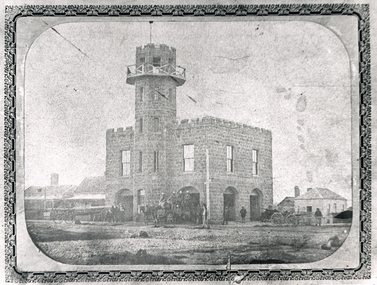
Photograph, Solomon and Bardwell, Western Fire Brigade Ballarat, c1861, c1861
... West Fire Brigade on the corner of Sturt Street and Raglan (north) Street. A number of fire carriages and uniformed men are evident in front of the fire station. Western Fire Brigade Ballarat, c1861 Photograph Solomon ...The former Ballarat West Fire Brigade is one of the oldest fire stations still standing in Victoria. Black and white photograph showing a double storey bluestone building with tower known as the Ballarat West Fire Brigade on the corner of Sturt Street and Raglan (north) Street. A number of fire carriages and uniformed men are evident in front of the fire station. ballarat west fire brigade, western fire brigade, bluestone -
 Federation University Historical Collection
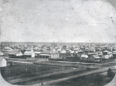
Photograph, Solomon and Bardwell, Ballarat From the Western Fire Brigade Tower Looking South
... Ballarat West Fire Brigade...Solomon...Barker Library (top floor) Mount Helen goldfields Ballarat Ballarat West Fire Brigade Solomon and Bardwell Black and white photograph of Ballarat taken from the Ballarat West Fire Brigade on the corner of Sturt Street and Raglan Street. ...Black and white photograph of Ballarat taken from the Ballarat West Fire Brigade on the corner of Sturt Street and Raglan Street. ballarat, ballarat west fire brigade, solomon and bardwell -
 Federation University Historical Collection
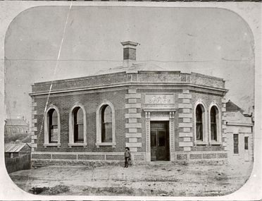
Photograph - Photograph - Black and White, Solomon and Bardwell, Ballarat Gas Office
... Barker Library (top floor) Mount Helen goldfields Ballarat Gasworks Ballarat Gas Office Solomon and Bardwell Photograph of a brick building with arch windows. It is the Ballarat Gas Office located on the south west corner of Grenville Street and Sturt Street. ...Photograph of a brick building with arch windows. It is the Ballarat Gas Office located on the south west corner of Grenville Street and Sturt Street.ballarat gasworks, ballarat gas office, solomon and bardwell -
 Federation University Historical Collection
Photograph - Photograph - Black and White, Sturt Street, Ballarat, 1861, 1861
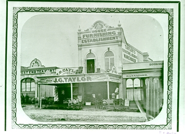
... Barker Library (top floor) Mount Helen goldfields The photograph is a copy of an item held by the State Library of Victoria, and copied by Keith Rash, c1970 j.g. taylor taylor's furniture and bedding warehouse hannaford bookseller west end tea mart a.r. hall Sturt Street Ballarat Black and White photograph of Sturt Street, Ballarat showing three shops: The West End Tea Mart, the double storey Taylor's Furniture and Bedding Warehouse, and Hannaford Bookseller. Sturt Street, Ballarat, 1861 Photograph Photograph - Black and White Solomon and bardwell ...The photograph is a copy of an item held by the State Library of Victoria, and copied by Keith Rash, c1970Black and White photograph of Sturt Street, Ballarat showing three shops: The West End Tea Mart, the double storey Taylor's Furniture and Bedding Warehouse, and Hannaford Bookseller. j.g. taylor, taylor's furniture and bedding warehouse, hannaford bookseller, west end tea mart, a.r. hall, sturt street, ballarat -
 Ballarat Tramway Museum
Photograph - Geelong 17 - Moorabool St, early 1930s
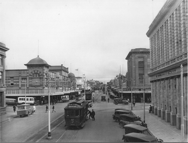
... West. Why it is turning at this location is unknown. In the background is another tram running south along Moorabool St along with other trams at the intersection with Ryrie St. The photo shows four buses parked on both streets. In the background are the Solomons...West. Why it is turning at this location is unknown. In the background is another tram running south along Moorabool St along with other trams at the intersection with Ryrie St. The photo shows four buses parked on both streets. In the background are the Solomons ...The photo taken at the corner of Moorabool and Malop Streets, is looking south along Moorabool St. Shows Geelong tram 17 tram about to turn "wrong line" from Moorabool St into Malop St. The tram has the destination of West. Why it is turning at this location is unknown. In the background is another tram running south along Moorabool St along with other trams at the intersection with Ryrie St. The photo shows four buses parked on both streets. In the background are the Solomons store, and the National Bank of Australasia buildings. Has many parked cars. The photo is pre 1934, before the construction of the T&G building at the corner of Moorabool and Ryrie Sts.Yields information about Geelong late 1930s and tramway operations.Black and white photograph - plain back.geelong, tram 17, moorabool st, malop st, tramways -
 Sunshine and District Historical Society Incorporated
Document - Sunshine And Deer Park Heritage Listed Reference Numbers
... Theresa Catholic Church & School 26 Adelaide Street Albion BCC H070 5741 - Sunshine And Deer Park Heritage Listed Reference Numbers Page 3.jpg Heritage Place (Cont) Curacloe BCC H073 Former Wunderlich Now West End Market 47 - 49 McIntyre Road Sunshine North BCC H073 Selwyn Park Albion BCC H074 Sunshine Baptist Church 42 Ridley Street & 16 Sydney Street Albion BCC H075 Cameron House & Dairy BCC H076 Houses & Trees 22 - 24 Talmage Street Albion BCC H077 Ford (Solomon Ford) Burke Road To Canning Street Avondale Heights BCC H079 Lions House Of Sunshine 8 Watt Street Sunshine BCC H080 Guiding Star Hotel 700 Geelong Road Brooklyn BCC H081 Hunt Club Hotel 775 Ballarat Road Deer Park BCC H082 Deer Park Hotel 760 Ballarat Road Deer Park BCC H083 Deer Park Primary School No 1434 812 Ballarat Road Deer Park BCC H084 Opie's Dairy 2 - 4 Egan Street Deer Park BCC H086 St. ...Theresa Catholic Church & School 26 Adelaide Street Albion BCC H070 5741 - Sunshine And Deer Park Heritage Listed Reference Numbers Page 3.jpg Heritage Place (Cont) Curacloe BCC H073 Former Wunderlich Now West End Market 47 - 49 McIntyre Road Sunshine North BCC H073 Selwyn Park Albion BCC H074 Sunshine Baptist Church 42 Ridley Street & 16 Sydney Street Albion BCC H075 Cameron House & Dairy BCC H076 Houses & Trees 22 - 24 Talmage Street Albion BCC H077 Ford (Solomon Ford) Burke Road To Canning Street Avondale Heights BCC H079 Lions House Of Sunshine 8 Watt Street Sunshine BCC H080 Guiding Star Hotel 700 Geelong Road Brooklyn BCC H081 Hunt Club Hotel 775 Ballarat Road Deer Park BCC H082 Deer Park Hotel 760 Ballarat Road Deer Park BCC H083 Deer Park Primary School No 1434 812 Ballarat Road Deer Park BCC H084 Opie's Dairy 2 - 4 Egan Street Deer Park BCC H086 St. ...Brimbank’s heritage‑listed properties are protected because they demonstrate important aspects of the area’s history — industrial innovation, early settlement, worker housing, civic development, and significant Aboriginal cultural landscapes. This document is an extract from the "Collection Document Project" prepared for Mr. Frank Ford, Sunshine & District Historical Society (See Catalogue No 5756). The document lists heritages place names, Brimbank Heritage Overlay Numbers and Victorian Heritage Register Numbers. Notes: 1. This list does not include heritage listed places from the former City of Sunshine currently in the City of Footscray. 2. This list does not include heritage listed places in St. Albans. 3. The date of this list is C2009.Heritage Listed Reference Numbers: Sunshine - Deer Park area 5741 - Sunshine And Deer Park Heritage Listed Reference Numbers Page 1.jpg Heritage Precincts Commonwealth Munitions Housing Estate BCC H019 Concrete Housing Estate Leith Avenue Sunshine BCC H020 ICI Residential Area Deer Park BCC H021 Sunshine Commercial Heritage Area BCC H022 McKay Housing Estate Durham Road BCC H023 McKay Housing Estate King Edward Avenue BCC H024 Railway Estate Sunshine BCC H025 War Service Homes Heritage Area Sunshine BCC H026 Heritage Place Massey Ferguson Complex Devonshire Road Sunshine BCC H03 VH H0667 John Darling & Son Flour Mill 74 Sydney Street Albion BCC H04 VH H0827 Rail Bridge (Albion Viaduct) Over Maribyrnong River BCC H05 VH H1197 Black Powder Mill Parklea Avenue And Grassy Point Road Cairnlea BCC H06 VH H2029 Foxley Lodge Farm And Its Drystone Walls 472A Boundary Road Derrimut BCC H08 1 Corio Steet Sunshine BCC H09 H.V. McKay Memorial Gardens BCC H010 VH 1953 H.V. McKay Offices 2 Devonshire Road Sunshine BCC H010 VH H1953 Main Outfall Sewer Brimbank (Brooklyn) BCC H013 VH H1932 Mt. Derrimut Homestead, Its Drystone Walls And Associated Buildings Including The Meteorological Centre Mt. Derrimut Road Derrimut BCC H017 5741 - Sunshine And Deer Park Heritage Listed Reference Numbers Page 2.jpg Heritage Place (Cont) Albion VR DC Substation Talmage Street Albion BCC H028 Pig And Calf Market 55 Market Road Brooklyn BCC H029 Monsanto Chemicals Huntsman Chemical Co 455 Somerville Road Brooklyn BCC H030 Deer Park Explosive Factories Complex Off Ballarat Road Deer Park BCC H032 Hume And Hovell Cairn Cnr Station Road And Ballarat Road Deer Park BCC H034 Sunshine Signal Box Off Hampshire Road BCC H039 Black Arch Rail Bridge Sunshine Road Sunshine BCC H040 Sugar Gum Row Talmage Street Albion BCC H042 Sunshine Advocate Office 11 - 15 Sun Crescent Sunshine BCC H051 H.V. McKay Memorial Gates Anderson Road Sunshine BCC H053 H.V. McKay Memorial Presbyterian Church Anderson Road Sunshine BCC H054 Sam McKay House And Garden 147 Anderson Road Sunshine BCC H055 Former Sunshine Technical School Derby Road Sunshine BCC H056 Former Sunshine Girls Technical School Derby Road Sunshine BCC H057 Pedestrian Footbridge Over Railway 1 Devonshire Road Sunshine BCC H058 House At 48 Station Place Sunshine BCC H061 ANZ Bank Former ES&A Bank 115 Durham Road Sunshine BCC H063 Sunshine Metropolitan Fire Station And Flats 330 Hampshire Road Sunshine BCC H064 Derrimut Hotel 132 Durham Road Sunshine BCC H065 St. Mark's Anglican Church 49 Suns Cresent Sunshine BCC H066 Robinson House 33 Sun Cresent Sunshine BCC H067 St. Theresa Catholic Church & School 26 Adelaide Street Albion BCC H070 5741 - Sunshine And Deer Park Heritage Listed Reference Numbers Page 3.jpg Heritage Place (Cont) Curacloe BCC H073 Former Wunderlich Now West End Market 47 - 49 McIntyre Road Sunshine North BCC H073 Selwyn Park Albion BCC H074 Sunshine Baptist Church 42 Ridley Street & 16 Sydney Street Albion BCC H075 Cameron House & Dairy BCC H076 Houses & Trees 22 - 24 Talmage Street Albion BCC H077 Ford (Solomon Ford) Burke Road To Canning Street Avondale Heights BCC H079 Lions House Of Sunshine 8 Watt Street Sunshine BCC H080 Guiding Star Hotel 700 Geelong Road Brooklyn BCC H081 Hunt Club Hotel 775 Ballarat Road Deer Park BCC H082 Deer Park Hotel 760 Ballarat Road Deer Park BCC H083 Deer Park Primary School No 1434 812 Ballarat Road Deer Park BCC H084 Opie's Dairy 2 - 4 Egan Street Deer Park BCC H086 St. John's Anglican Church & Hall 2 - 4 Miles Street Deer Park BCC H087 Neale Road Ford 192 Neale Road Deer Park BCC H088 Deer Park Hall 50 Station Road Deer Park BCC H089 Sunshine Market 13 - 19 City Place Sunshine BCC H091 Methodist Church & Hall 32 Devonshire Road Sunshine BCC H0105 Macedonian Community Centre 45 Fourth Avenue Sunshine BCC H0106 Hannah McKay House 145 Anderson Road Albion BCC H0107 Chemist Shop 234 Hampshire Road Sunshine BCC H0108 Sunshine Municipal Offices 6 - 18 Alexandra Avenue Sunshine BCC H0109 Sunshine Primary School 3113 111 Derby Road Sunshine BCC H0110 Standard Steel 12 - 16 Market Road Sunshine BCC H0111 Our Lady of the Immaculate Conception Catholic Church 93 Monash Street Sunshine BCC H0113 Parsons House 114 Moris Street Sunshine BCC H0114 Our Lady's School Station Place Monash Street Sunshine BCC H0115 Palmas 2 Tyler Street Sunshine BCC H0116 St. Andrews Greek Orthodox Church (Greek Cypriot) 14 Simmie Street Sunshine West BCC H0119 5741 - Sunshine And Deer Park Heritage Listed Reference Numbers Page 4.jpg Heritage Place (Cont) William McKay House 150 Durham Road Sunshine BCC H0121 Albion Primary School No 4265 61 - 81 Adelaide Street Albion BCC H0122 Ralph's Meatworks 690 Geelong Road Brooklyn BCC H0123 Former Church of Christ 81 - 83 Hampshire Road Sunshine BCC H0125 Former Masonic Lodge No 226 93 Hampshire Road Sunshine BCC H0126 Sunshine Picture Theatre 126 - 128 Hampshire Road Sunshine BCC H0127 Shops 193 - 199 Hampshire Road Sunshine BCC H0130 Ukrainian Catholic Church 2 Holmes Street Ardeer BCC H0132 Shops 207 - 219 Hampshire Road Sunshine BCC H0133 Victorian Row House 25 Benjamin Street Sunshine BCC H0134 Victorian Row House 29 Benjamin Street Sunshine BCC H0135 Victorian Row House 31 Benjamin Street Sunshine BCC H0136 Victorian Row House 33 Benjamin Street Sunshine BCC H0137 Victorian Row House 35 Benjamin Street Sunshine BCC H0138 50 Forrest Street Albion BCC H0139 -
 Sunshine and District Historical Society Incorporated
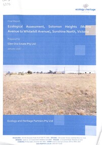
Document - Solomon Heights Ecological Assessment Final Report, Ecology and Heritage Partners Pty Ltd, 22nd January 2016
... The area of Solomon Heights covered by this report is the southern half, Whitehill Avenue to the North, Munro Avenue to the South, Vermont Avenue to the East and the railway line to the West....The area of Solomon Heights covered by this report is the southern half, Whitehill Avenue to the North, Munro Avenue to the South, Vermont Avenue to the East and the railway line to the West. ...Solomon Heights in Sunshine North is a 1920s subdivision that was never built, later rezoned industrial, and today remains an undeveloped patchwork of grasslands, quarries, and paper roads. The estate is named after Michael Solomon, an early pastoralist whose 1830s sheep station and nearby Solomon’s Ford were key early European landmarks on the Maribyrnong River. This report was undertaken to identify and characterise the vegetation on-site, to determine the presence (or likelihood thereof) of any significant flora and fauna species and/or ecological communities and address any implications under Commonwealth and State environmental legislation. The area of Solomon Heights covered by this report is the southern half, Whitehill Avenue to the North, Munro Avenue to the South, Vermont Avenue to the East and the railway line to the West.The results of the report found 78 flora species (35 indigenous and 43 non-indigenous), 2 native reptiles, 2 introduced mammals, 12 birds (8 natives and 4 introduced) and 1 native invertebrate were recorded in the study area.Final Report Ecological Assessment, Solomon Heights (Munro Avenue to Whitehill Avenue) Sunshine North, Victoria Prepared for Glen Ora Estate Pty Ltd January 2016 Ecology and Heritage Parnters Pty Ltdsolomon heights, sunshine north -
 Sunshine and District Historical Society Incorporated
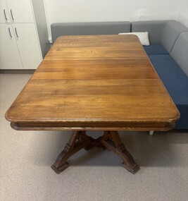
Functional object - Shire Of Braybrook Table
... The Shire of Braybrook (1871–1951) was a vast, semi‑rural municipality stretching from Melton to West Melbourne, centred on the old Braybrook village at Solomon’s Ford. It transformed dramatically with the arrival of railways, the rise of Braybrook Junction/Sunshine, and the industrial boom driven by H.V. ...Brimbank Library, 301 Hampshire Road, Sunshine 3020. melbourne The Shire of Braybrook (1871–1951) was a vast, semi‑rural municipality stretching from Melton to West Melbourne, centred on the old Braybrook village at Solomon’s Ford. It transformed dramatically with the arrival of railways, the rise of Braybrook Junction/Sunshine, and the industrial boom driven by H.V. ...The Shire of Braybrook (1871–1951) was a vast, semi‑rural municipality stretching from Melton to West Melbourne, centred on the old Braybrook village at Solomon’s Ford. It transformed dramatically with the arrival of railways, the rise of Braybrook Junction/Sunshine, and the industrial boom driven by H.V. McKay’s Harvester Works. The area was first organised as the Braybrook Road District on 28th May 1860, after a public meeting at the Shamrock Hotel in Albion. The district was enormous, extending from Melton to Dynon Road on the West Melbourne swamp. Early settlement clustered around Solomon’s Ford on the Maribyrnong River, a key crossing for travelers heading to Geelong, Williamstown, and the goldfields. On 23rd January 1871, the Road District became the Shire of Braybrook. Council meetings were initially held in Maidstone, reflecting the early population centres. The Braybrook Shire Hall in Deer Park was built in 1885. That 1885 building was the first official hall and council offices for the Shire of Braybrook, long before the municipality shifted its centre of gravity toward Sunshine. It stood near the Deer Park Hotel and served as the administrative heart of the shire during the late 19th century. The Braybrook Shire Hall at Deer Park effectively closed as a council headquarters in 1930, when the Shire of Braybrook shifted its administrative centre to Sunshine. In 1951, the Shire of Braybrook was renamed the City of Sunshine, reflecting the shift of population and industry eastward. In 1994 - 1995 the Kennett Government reduced Victoria’s councils from 210 to 78, the largest restructuring of local government in the state’s history and this part of the City of Sunshine became the City of Brimbank. It is believed this extension table came from the Shire of Braybrook Shire Office located in Ballarat Road, Deer Park, opposite the Deer Park Hotel. Over the years this extension table was used in the Shire of Braybrook Shire Office Ballarat Road Deer Park, the Shire of Braybrook and City of Sunshine Memorial Hall Hampshire Road Sunshine and in the City of Sunshine Municipal Offices Alexandra Avenue Sunshine. When the City of Sunshine Municipal Offices in Alexandra Avenue, Sunshine closed down, this table was were presented to the Sunshine & District Historical Society by the City of Brimbank. The table is still in use by the staff at The Hunt Club Community Arts Centre, Ballarat Road, Deer Park.This table is one of the few remaining items that still connects us to the early days of the Shire of Braybrook.Wood extension table with two extension leaves and carved legs.shire of braybrook, shire of braybrook offices, ballarat road, deer park -
 Sunshine and District Historical Society Incorporated
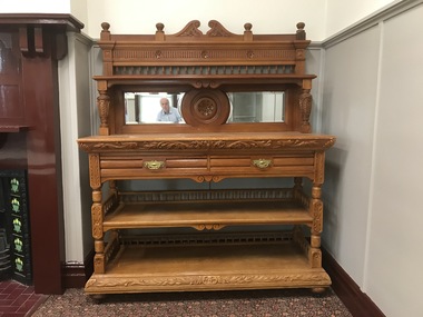
Functional object - Shire Of Braybrook Sideboard
... The Shire of Braybrook (1871–1951) was a vast, semi‑rural municipality stretching from Melton to West Melbourne, centred on the old Braybrook village at Solomon’s Ford. It transformed dramatically with the arrival of railways, the rise of Braybrook Junction/Sunshine, and the industrial boom driven by H.V. ...Brimbank Library, 301 Hampshire Road, Sunshine 3020. melbourne The Shire of Braybrook (1871–1951) was a vast, semi‑rural municipality stretching from Melton to West Melbourne, centred on the old Braybrook village at Solomon’s Ford. It transformed dramatically with the arrival of railways, the rise of Braybrook Junction/Sunshine, and the industrial boom driven by H.V. ...The Shire of Braybrook (1871–1951) was a vast, semi‑rural municipality stretching from Melton to West Melbourne, centred on the old Braybrook village at Solomon’s Ford. It transformed dramatically with the arrival of railways, the rise of Braybrook Junction/Sunshine, and the industrial boom driven by H.V. McKay’s Harvester Works. The area was first organised as the Braybrook Road District on 28th May 1860, after a public meeting at the Shamrock Hotel in Albion. The district was enormous, extending from Melton to Dynon Road on the West Melbourne swamp. Early settlement clustered around Solomon’s Ford on the Maribyrnong River, a key crossing for travelers heading to Geelong, Williamstown, and the goldfields. On 23rd January 1871, the Road District became the Shire of Braybrook. Council meetings were initially held in Maidstone, reflecting the early population centres. The Braybrook Shire Hall in Deer Park was built in 1885. That 1885 building was the first official hall and council offices for the Shire of Braybrook, long before the municipality shifted its centre of gravity toward Sunshine. It stood near the Deer Park Hotel and served as the administrative heart of the shire during the late 19th century. The Braybrook Shire Hall at Deer Park effectively closed as a council headquarters in 1930, when the Shire of Braybrook shifted its administrative centre to Sunshine. In 1951, the Shire of Braybrook was renamed the City of Sunshine, reflecting the shift of population and industry eastward. In 1994 - 1995 the Kennett Government reduced Victoria’s councils from 210 to 78, the largest restructuring of local government in the state’s history and this part of the City of Sunshine became the City of Brimbank. It is believed this extension table came from the Shire of Braybrook Shire Office located in Ballarat Road, Deer Park, opposite the Deer Park Hotel. Over the years this sideboard was used in the Shire of Braybrook Shire Office Ballarat Road Deer Park, the Shire of Braybrook and City of Sunshine Memorial Hall Hampshire Road Sunshine and in the City of Sunshine Municipal Offices Alexandra Avenue Sunshine where it was used in the Mayoral's council chambers. When the City of Sunshine Municipal Offices in Alexandra Avenue, Sunshine closed down, this sideboard was presented to the Sunshine & District Historical Society by the City of Brimbank.This sideboard is one of the few remaining items that still connects us to the early days of the Shire of Braybrook.French renaissance styled carved walnut sideboard with mirrored backplate.shire of braybrook, shire of braybrook offices, ballarat road, deer park -
 Sunshine and District Historical Society Incorporated
Photograph - Braybrook Photographs 2021, John Alchin, 2021
... West Shopping Centre...National Springs...Ashley Hotel...ETA Factory...La Porchetta...Braybrook Hotel...Klipspringer...Harkrome...Steeden Engineering...Sunshine VRI Bowling Club...RecWest...Kinder Smith Reserve...Marj Laffin...Salvation Army Hall...Quang Minh Buddhist Temple...Burke Street...Ramon Vila Pavilion...Solomon...Ballarat Road Ashley Street Beachkey Street Cranwell Street Darnley Street Duke Street Evans Street Gilbert Street Hampden Street Kent Street Lily Street Maribyrnong River Myalla Street South Road 3LO Radio Transmitter Central West Shopping Centre National Springs Ashley Hotel ETA Factory La Porchetta Braybrook Hotel Klipspringer Harkrome Steeden Engineering Sunshine VRI Bowling Club RecWest Kinder Smith Reserve Marj Laffin Salvation Army Hall Quang Minh Buddhist Temple Burke Street Ramon Vila Pavilion Solomon Ford Caroline Chisholm College William Barak Aboriginal Aborigine First Nation Braybrook 5580.01 - Ashley St - Former 3LO - AWA Frequency changing building 2021 Photo 01.JPG 5580.02 - Ashley St 65- 67 Braybrook - Central West Shopping Centre 2021 Photo 02.JPG 5580.03 - Ashley St 185 - 195 Braybrook - Former National Springs 2021 Photo 01.JPG 5580.04 - Ballarat Rd 226 Braybrook - Ashley Hotel Ballarat Rd 2021 Photo 01.JPG 5580.05 - Ballarat Rd 234 Braybrook 2021 Photo 01.JPG 5580.06 - Ballarat Rd 234 Braybrook 2021 Photo 02.JPG 5580.07 - Ballarat Rd 244 - 246 Braybrook 2021 Photo 01.JPG 5580.08 - Ballarat Rd 256 Braybrook - ETA Factory Facade 2021 Photo 02.JPG 5580.09 - Ballarat Rd 256 Braybrook - ETA Factory Facade 2021 Photo 04.JPG 5580.10 - Ballarat Rd 261 Braybrook - La Porchetta 2021 Photo 01.JPG 5580.11 - Ballarat Rd 272 Braybrook - Former Holden Car Dealership 2021 Photo 01.JPG 5580.12 - Ballarat Rd 282 Braybrook 2021 Photo 02.JPG 5580.13 - Ballarat Rd 286 - 288 Braybrook 2021 Photo 01.JPG 5580.14 - Ballarat Rd 288 - 290 Braybrook 2021 Photo 01.JPG 5580.15 - Ballarat Rd 290 - 292 Braybrook 2021 Photo 01.JPG 5580.16 - Ballarat Rd 306 - 308 Braybrook 2021 Photo 01.JPG 5580.17 - Ballarat Rd 353 Braybrook - Braybrook Hotel 2021 Photo 01.JPG 5580.18 - Ballarat Rd 353 Braybrook - Braybrook Hotel 2021 Photo 02.JPG 5580.19 - Ballarat Rd 353 Braybrook - Braybrook Hotel 2021 Photo 03.JPG 5580.20 - Ballarat Rd 353 Braybrook - Braybrook Hotel Blue Stone Bar Sign 2021 Photo 01.JPG 5580.21 - Beachley St 23 - 33 Braybrook - Shops 2021 Photo 01.JPG 5580.22 - Beachley St 23 - 33 Braybrook - Shops 2021 Photo 02.JPG 5580.23 - Braybrook Commons Community Gardens Skinner Reserve 2021 Photo 01.JPG 5580.24 - Cranwell St 40 Braybrook - Klipspringer 2021 Photo 02.JPG 5580.25 - Darnley St 83 Braybrook 2021 Photo 01.JPG 5580.26 - Duke St 144 Braybrook 2021 Photo 01.JPG 5580.27 - Evans St 1 Braybrook - Harkrome Quality Electroplaters 2021 Photo 01.JPG 5580.28 - Evans St 9 Braybrook 2021 Photo 01.JPG 5580.29 - Gilbert St 8 Braybrrok - Steeden Engineering Co Pty Ltd 2021 Photo 01.JPG 5580.30 - Hampden St Factory Demolishment 2021 Photo 01.JPG 5580.31 - Kent St Braybrook - Sunshine VRI Bowling Club 2021 Photo 01.JPG 5580.32 - Kent St Braybrook - Sunshine VRI Bowling Club 2021 Photo 02.JPG 5580.33 - Kent St Braybrook - Sunshine VRI Bowling Club 2021 Photo 03.JPG 5580.34 - Lily st Braybrook - RecWest 2021 Photo 01.JPG 5580.35 - Maribyrnong River Temple to Temple Trail Sign 2021 Photo 01.JPG 5580.36 - Maribyrnong River Braybrook 2021 Photo 01.JPG 5580.37 - Marj Laffin Scoreboard Kinder Smith Reserve Lily St Braybrook 2021 Photo 01.JPG 5580.38 - Myalla St 40 Braybrook - Salvation Army Hall 2021 Photo 01.JPG 5580.39 - Myalla St 40 Braybrook - Salvation Army Hall 2021 Photo 02.JPG 5580.40 - Quang Minh Buddhist Temple Burke St Braybrook 2021 Photo 01.JPG 5580.41 - Quang Minh Buddhist Temple Gardens Braybrook 2021 Photo 04.JPG 5580.42 - Ramon Vila Pavilion Kinder Smith Reserve Lily St Braybrook 2021 Photo 01.JPG 5580.43 - Solomon Ford Maribyrnong River 2021 Photo 01.JPG 5580.44 - South Rd 204 Braybrook - Caroline Chisholm College Braybrook 2021 Photo 01.JPG 5580.45 - South Rd 204 Braybrook - Caroline Chisholm College Quinn Auditorium Braybrook 2021 Photo 01.JPG 5580.46 - William Barak Sign Duke St Reserve Braybrook 2021 Photo 01.JPG Collection of digital photographs Photograph Braybrook Photographs 2021 John Alchin ...Braybrook was originally part of the former Shire of Braybrook and later the City of Sunshine. However, in 1994, Victoria underwent council amalgamations, which resulted in Braybrook being incorporated into the City of Maribyrnong. The suburb of Braybrook continues to attract considerable attention from the residents of City of Brimbank, particularly its historical features, the old buildings and distinctive streetscapes that characterise the area.To capture the essence of Braybrook in 2021, a series of photographs were taken. These images document a range of buildings, street scenes, and other notable points of interest throughout the suburb, providing a visual record of its unique character.5580.01 - Ashley St - Former 3LO - AWA Frequency changing building 2021 Photo 01.JPG 5580.02 - Ashley St 65- 67 Braybrook - Central West Shopping Centre 2021 Photo 02.JPG 5580.03 - Ashley St 185 - 195 Braybrook - Former National Springs 2021 Photo 01.JPG 5580.04 - Ballarat Rd 226 Braybrook - Ashley Hotel Ballarat Rd 2021 Photo 01.JPG 5580.05 - Ballarat Rd 234 Braybrook 2021 Photo 01.JPG 5580.06 - Ballarat Rd 234 Braybrook 2021 Photo 02.JPG 5580.07 - Ballarat Rd 244 - 246 Braybrook 2021 Photo 01.JPG 5580.08 - Ballarat Rd 256 Braybrook - ETA Factory Facade 2021 Photo 02.JPG 5580.09 - Ballarat Rd 256 Braybrook - ETA Factory Facade 2021 Photo 04.JPG 5580.10 - Ballarat Rd 261 Braybrook - La Porchetta 2021 Photo 01.JPG 5580.11 - Ballarat Rd 272 Braybrook - Former Holden Car Dealership 2021 Photo 01.JPG 5580.12 - Ballarat Rd 282 Braybrook 2021 Photo 02.JPG 5580.13 - Ballarat Rd 286 - 288 Braybrook 2021 Photo 01.JPG 5580.14 - Ballarat Rd 288 - 290 Braybrook 2021 Photo 01.JPG 5580.15 - Ballarat Rd 290 - 292 Braybrook 2021 Photo 01.JPG 5580.16 - Ballarat Rd 306 - 308 Braybrook 2021 Photo 01.JPG 5580.17 - Ballarat Rd 353 Braybrook - Braybrook Hotel 2021 Photo 01.JPG 5580.18 - Ballarat Rd 353 Braybrook - Braybrook Hotel 2021 Photo 02.JPG 5580.19 - Ballarat Rd 353 Braybrook - Braybrook Hotel 2021 Photo 03.JPG 5580.20 - Ballarat Rd 353 Braybrook - Braybrook Hotel Blue Stone Bar Sign 2021 Photo 01.JPG 5580.21 - Beachley St 23 - 33 Braybrook - Shops 2021 Photo 01.JPG 5580.22 - Beachley St 23 - 33 Braybrook - Shops 2021 Photo 02.JPG 5580.23 - Braybrook Commons Community Gardens Skinner Reserve 2021 Photo 01.JPG 5580.24 - Cranwell St 40 Braybrook - Klipspringer 2021 Photo 02.JPG 5580.25 - Darnley St 83 Braybrook 2021 Photo 01.JPG 5580.26 - Duke St 144 Braybrook 2021 Photo 01.JPG 5580.27 - Evans St 1 Braybrook - Harkrome Quality Electroplaters 2021 Photo 01.JPG 5580.28 - Evans St 9 Braybrook 2021 Photo 01.JPG 5580.29 - Gilbert St 8 Braybrrok - Steeden Engineering Co Pty Ltd 2021 Photo 01.JPG 5580.30 - Hampden St Factory Demolishment 2021 Photo 01.JPG 5580.31 - Kent St Braybrook - Sunshine VRI Bowling Club 2021 Photo 01.JPG 5580.32 - Kent St Braybrook - Sunshine VRI Bowling Club 2021 Photo 02.JPG 5580.33 - Kent St Braybrook - Sunshine VRI Bowling Club 2021 Photo 03.JPG 5580.34 - Lily st Braybrook - RecWest 2021 Photo 01.JPG 5580.35 - Maribyrnong River Temple to Temple Trail Sign 2021 Photo 01.JPG 5580.36 - Maribyrnong River Braybrook 2021 Photo 01.JPG 5580.37 - Marj Laffin Scoreboard Kinder Smith Reserve Lily St Braybrook 2021 Photo 01.JPG 5580.38 - Myalla St 40 Braybrook - Salvation Army Hall 2021 Photo 01.JPG 5580.39 - Myalla St 40 Braybrook - Salvation Army Hall 2021 Photo 02.JPG 5580.40 - Quang Minh Buddhist Temple Burke St Braybrook 2021 Photo 01.JPG 5580.41 - Quang Minh Buddhist Temple Gardens Braybrook 2021 Photo 04.JPG 5580.42 - Ramon Vila Pavilion Kinder Smith Reserve Lily St Braybrook 2021 Photo 01.JPG 5580.43 - Solomon Ford Maribyrnong River 2021 Photo 01.JPG 5580.44 - South Rd 204 Braybrook - Caroline Chisholm College Braybrook 2021 Photo 01.JPG 5580.45 - South Rd 204 Braybrook - Caroline Chisholm College Quinn Auditorium Braybrook 2021 Photo 01.JPG 5580.46 - William Barak Sign Duke St Reserve Braybrook 2021 Photo 01.JPG ballarat road, ashley street, beachkey street, cranwell street, darnley street, duke street, evans street, gilbert street, hampden street, kent street, lily street, maribyrnong river, myalla street, south road, 3lo radio transmitter, central west shopping centre, national springs, ashley hotel, eta factory, la porchetta, braybrook hotel, klipspringer, harkrome, steeden engineering, sunshine vri bowling club, recwest, kinder smith reserve, marj laffin, salvation army hall, quang minh buddhist temple, burke street, ramon vila pavilion, solomon ford, caroline chisholm college, william barak, aboriginal, aborigine, first nation, braybrook -
 Sunshine and District Historical Society Incorporated
Document - Solomon Heights
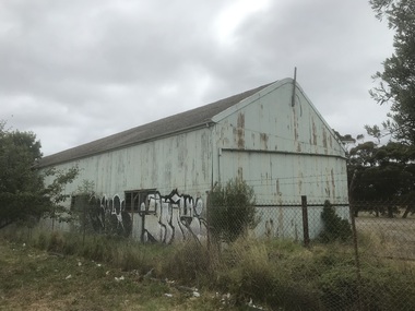
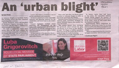
... Solomon Heights is a 32–33 hectare pocket of Sunshine North, bounded by Baldwin Avenue, Munro Avenue, Vermont Avenue (south), Albion–Jacana railway line (west) and Maribyrnong River (north & east). ...Brimbank Library, 301 Hampshire Road, Sunshine 3020. melbourne Solomon Heights is a 32–33 hectare pocket of Sunshine North, bounded by Baldwin Avenue, Munro Avenue, Vermont Avenue (south), Albion–Jacana railway line (west) and Maribyrnong River (north & east). ...Solomon Heights is a 32–33 hectare pocket of Sunshine North, bounded by Baldwin Avenue, Munro Avenue, Vermont Avenue (south), Albion–Jacana railway line (west) and Maribyrnong River (north & east). In the 1920s, developers carved the land into 433 to 435 lots, but the estate never received roads, drainage, sewerage, or power. By 2025, it still had, unmade roads, no services, no development of any kind. The parcel of land has the presence of critically endangered flora and fauna species which is protected under federal and state laws. One of the flora species is the spiny rice flower, a small plant with spike tipped stems and pale yellow flowers. 5682.01 - Solomon Heights - An Urban Blight Part 1.JPG 5682.01 - Solomon Heights - An Urban Blight Part 2.JPG 5682.02 - Solomon Heights Strategic Assessment Agreement.pdf 5682.03 - Solomon Heights Glen Ora Estate Pty Ltd V's Brimbank City Council Court Judgment.pdf 5682.04 - Solomon Heights Estate Southern Section Map.pdf 5682.05 - Solomon Heights Land Use Planning Options Brimbank Ordinary Council Meeting.pdf 5682.06 - Lets Save Solomon Heights Grassland Nature For All Of Us Poster.pfdsolomon heights, sunshine north, michael solomon, spiny rice flower -
 Sunshine and District Historical Society Incorporated
Archive - Maribyrnong River, Meat Works & the Living Museum of the West
... Sketch Humes Site Maribyrnong The Processes of Meat Preserving The Tin Shop|Sketch Humes Site Maribyrnong The Processes of Meat Preserving The Works|Sketch Humes Site Maribyrnong The Processes of Meat Preserving The Store Room|Sketch Humes Site Maribyrnong The Processes of Meat Preserving The Kitchen|Sketch Humes Site Maribyrnong The Processes of Meat Preserving The Preserving Room|Sketch Humes Site Maribyrnong The Processes of Meat Preserving The Boning Room|Sketch Humes Site Maribyrnong The Processes of Meat Preserving|Photograph Humes Site Maribyrnong|Newspaper article The Advocate 14 June 1995 Cannery building highlight at park|Newspaper article Times 12 February 2002 Chemical free restoration|Extract ADI Footscray Site Redevelopment Site History Historical Overview|Brochure Discover the Maribyrnong|Newspaper article Essendon Gazette 3 March 2021 Long Distance Swim|Newspaper article Star 4 May 2004 Plan to save Cinderella river|Typed Report Memories of early Maribyrnong|Newspaper article The Herald 11 December 1981 The battle over the bluestone|Plans Kevin McManus Architect Possible Development Humes Site Maribyrnong|Photocopy painting of Humes Site Maribyrnong|Newspaper article The Sun 1 June 1979 A face lift for our Cinderella River|Newspaper article The Age 9 November 1982 Messsing about on the forgotten river|Extract Our Unique Victorian Timber Bridge Heritage article|Invitation to a Meeting Our River Heritage and its future|Typed Report February 1992 Maribyrnong River Valley Braybrook A time of Achievement of community Aspirations|Letter 14 February 1983 from Melbourne and Metropolitan Board of Works|Typed Notes Meeting to discuss the erection of a cairn at Solomons Ford|Letter 30 July 1980 from Melbourne and Metropolitan Board of Works Former Melbourne Meat Preserving Company Maribyrnong|Letter 1 December 1981 to Melbourne and Metropolitan Board of Works from Melbourne Metropolitan Planning Scheme Amendment No 157|Extract Maribyrnong Action in Tranquility by Olwen Ford and Pamela Lewis|Handwritten notes about Maribyrnong|Typed report 11 September 1976 Maribyrnong History|Newspaper article The Mail 10 February 1993 Maribyrnong turns back the clock|Newspaper article Advocate 29 September 1993 Misery of flood victims to continue Govt rejects river report|Newspaper article Sunshine Advocate 28M Arundel Dam plan scrapped|Flyer The Maribyrnong River Ideas for the River Valley|Newspaper article The Western Times 12 September 1984 Govt breathes new life into a forgotten river|Newspaper article The Western Times 8 February 1984 So where is the real Solomons Ford|Letter 28 April 1960 Maribyrnong|Newspaper article Melbourne must not forget its other river Olwen Ford|Flyer Ecomuseum Broadsheets 4 Maribyrnong River A River of Histoy|Flyer Pipemakers Park Maribyrnong|Typed report The Saltwater River Powder Magazine Jacks Magazine J W Moore|The Heritage Plan Maribyrnong City Council February 2002|Flyer Bicycling in Maribyrnong|Flyer Pipe Trail|Flyer Meat Trail|Flyer Origins of Industry|Flyer Pipemakers Park|Typed Report Racing Colours Rose and Black|Photographs Maribyrnong Valley December 1974|Newspaper article Herald Sun 12/2/1991 - How the live west is won Pipemakers Park...Maribyrnong River Meat Works The Living Museum of the West Sketch Humes Site Maribyrnong The Processes of Meat Preserving The Tin Shop|Sketch Humes Site Maribyrnong The Processes of Meat Preserving The Works|Sketch Humes Site Maribyrnong The Processes of Meat Preserving The Store Room|Sketch Humes Site Maribyrnong The Processes of Meat Preserving The Kitchen|Sketch Humes Site Maribyrnong The Processes of Meat Preserving The Preserving Room|Sketch Humes Site Maribyrnong The Processes of Meat Preserving The Boning Room|Sketch Humes Site Maribyrnong The Processes of Meat Preserving|Photograph Humes Site Maribyrnong|Newspaper article The Advocate 14 June 1995 Cannery building highlight at park|Newspaper article Times 12 February 2002 Chemical free restoration|Extract ADI Footscray Site Redevelopment Site History Historical Overview|Brochure Discover the Maribyrnong|Newspaper article Essendon Gazette 3 March 2021 Long Distance Swim|Newspaper article Star 4 May 2004 Plan to save Cinderella river|Typed Report Memories of early Maribyrnong|Newspaper article The Herald 11 December 1981 The battle over the bluestone|Plans Kevin McManus Architect Possible Development Humes Site Maribyrnong|Photocopy painting of Humes Site Maribyrnong|Newspaper article The Sun 1 June 1979 A face lift for our Cinderella River|Newspaper article The Age 9 November 1982 Messsing about on the forgotten river|Extract Our Unique Victorian Timber Bridge Heritage article|Invitation to a Meeting Our River Heritage and its future|Typed Report February 1992 Maribyrnong River Valley Braybrook A time of Achievement of community Aspirations|Letter 14 February 1983 from Melbourne and Metropolitan Board of Works|Typed Notes Meeting to discuss the erection of a cairn at Solomons Ford|Letter 30 July 1980 from Melbourne and Metropolitan Board of Works Former Melbourne Meat Preserving Company Maribyrnong|Letter 1 December 1981 to Melbourne and Metropolitan Board of Works from Melbourne Metropolitan Planning Scheme Amendment No 157|Extract Maribyrnong Action in Tranquility by Olwen Ford and Pamela Lewis|Handwritten notes about Maribyrnong|Typed report 11 September 1976 Maribyrnong History|Newspaper article The Mail 10 February 1993 Maribyrnong turns back the clock|Newspaper article Advocate 29 September 1993 Misery of flood victims to continue Govt rejects river report|Newspaper article Sunshine Advocate 28M Arundel Dam plan scrapped|Flyer The Maribyrnong River Ideas for the River Valley|Newspaper article The Western Times 12 September 1984 Govt breathes new life into a forgotten river|Newspaper article The Western Times 8 February 1984 So where is the real Solomons Ford|Letter 28 April 1960 Maribyrnong|Newspaper article Melbourne must not forget its other river Olwen Ford|Flyer Ecomuseum Broadsheets 4 Maribyrnong River A River of Histoy|Flyer Pipemakers Park Maribyrnong|Typed report The Saltwater River Powder Magazine Jacks Magazine J W Moore|The Heritage Plan Maribyrnong City Council February 2002|Flyer Bicycling in Maribyrnong|Flyer Pipe Trail|Flyer Meat Trail|Flyer Origins of Industry|Flyer Pipemakers Park|Typed Report Racing Colours Rose and Black|Photographs Maribyrnong Valley December 1974|Newspaper article Herald Sun 12/2/1991 - How the live west is won Pipemakers Park Collection of articles relating to the Maribyrnong River Meat Works Living Museum of the West and other articles relating to the Maribyrnong River Archive Maribyrnong River, Meat Works & the Living Museum of the West ...Sketch Humes Site Maribyrnong The Processes of Meat Preserving The Tin Shop|Sketch Humes Site Maribyrnong The Processes of Meat Preserving The Works|Sketch Humes Site Maribyrnong The Processes of Meat Preserving The Store Room|Sketch Humes Site Maribyrnong The Processes of Meat Preserving The Kitchen|Sketch Humes Site Maribyrnong The Processes of Meat Preserving The Preserving Room|Sketch Humes Site Maribyrnong The Processes of Meat Preserving The Boning Room|Sketch Humes Site Maribyrnong The Processes of Meat Preserving|Photograph Humes Site Maribyrnong|Newspaper article The Advocate 14 June 1995 Cannery building highlight at park|Newspaper article Times 12 February 2002 Chemical free restoration|Extract ADI Footscray Site Redevelopment Site History Historical Overview|Brochure Discover the Maribyrnong|Newspaper article Essendon Gazette 3 March 2021 Long Distance Swim|Newspaper article Star 4 May 2004 Plan to save Cinderella river|Typed Report Memories of early Maribyrnong|Newspaper article The Herald 11 December 1981 The battle over the bluestone|Plans Kevin McManus Architect Possible Development Humes Site Maribyrnong|Photocopy painting of Humes Site Maribyrnong|Newspaper article The Sun 1 June 1979 A face lift for our Cinderella River|Newspaper article The Age 9 November 1982 Messsing about on the forgotten river|Extract Our Unique Victorian Timber Bridge Heritage article|Invitation to a Meeting Our River Heritage and its future|Typed Report February 1992 Maribyrnong River Valley Braybrook A time of Achievement of community Aspirations|Letter 14 February 1983 from Melbourne and Metropolitan Board of Works|Typed Notes Meeting to discuss the erection of a cairn at Solomons Ford|Letter 30 July 1980 from Melbourne and Metropolitan Board of Works Former Melbourne Meat Preserving Company Maribyrnong|Letter 1 December 1981 to Melbourne and Metropolitan Board of Works from Melbourne Metropolitan Planning Scheme Amendment No 157|Extract Maribyrnong Action in Tranquility by Olwen Ford and Pamela Lewis|Handwritten notes about Maribyrnong|Typed report 11 September 1976 Maribyrnong History|Newspaper article The Mail 10 February 1993 Maribyrnong turns back the clock|Newspaper article Advocate 29 September 1993 Misery of flood victims to continue Govt rejects river report|Newspaper article Sunshine Advocate 28M Arundel Dam plan scrapped|Flyer The Maribyrnong River Ideas for the River Valley|Newspaper article The Western Times 12 September 1984 Govt breathes new life into a forgotten river|Newspaper article The Western Times 8 February 1984 So where is the real Solomons Ford|Letter 28 April 1960 Maribyrnong|Newspaper article Melbourne must not forget its other river Olwen Ford|Flyer Ecomuseum Broadsheets 4 Maribyrnong River A River of Histoy|Flyer Pipemakers Park Maribyrnong|Typed report The Saltwater River Powder Magazine Jacks Magazine J W Moore|The Heritage Plan Maribyrnong City Council February 2002|Flyer Bicycling in Maribyrnong|Flyer Pipe Trail|Flyer Meat Trail|Flyer Origins of Industry|Flyer Pipemakers Park|Typed Report Racing Colours Rose and Black|Photographs Maribyrnong Valley December 1974|Newspaper article Herald Sun 12/2/1991 - How the live west is won Pipemakers Parkmaribyrnong river, meat works, the living museum of the west -
 Kew Historical Society Inc
Photograph - Deep Rock Swimming Pool and Clubrooms on the Yarra, c.1925
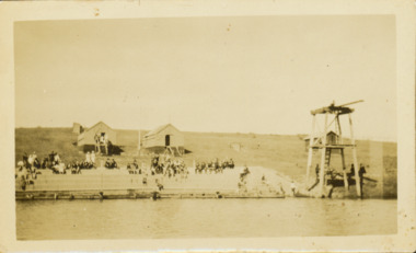
... The ‘pool’ was to achieve fame as the venue for a world record-breaking ‘swallow dive’ of 205 feet 9 inches [63 metres] by ‘Prince Wickyama’, [aka Alec Wickham], a Solomon Islander. The dive from a special platform on the west side of the Yarra was reputedly viewed by between 50,000-100,000 spectators, with funds going to the State War Council. ...The ‘pool’ was to achieve fame as the venue for a world record-breaking ‘swallow dive’ of 205 feet 9 inches [63 metres] by ‘Prince Wickyama’, [aka Alec Wickham], a Solomon Islander. The dive from a special platform on the west side of the Yarra was reputedly viewed by between 50,000-100,000 spectators, with funds going to the State War Council. ...The former Deep Rock Swimming Pool was about 500 yards [457 metres] above Dight’s Falls. It was there that the Deep Rock Swimming Club was established in 1906. This initial club was expanded in 1916 to incorporate a life-saving club. In 1918, John Wren, the president of the club offered the club £1000, and undertook to sponsor a patriotic carnival in March 1918, at which swimming champions would take part. The ‘pool’ was to achieve fame as the venue for a world record-breaking ‘swallow dive’ of 205 feet 9 inches [63 metres] by ‘Prince Wickyama’, [aka Alec Wickham], a Solomon Islander. The dive from a special platform on the west side of the Yarra was reputedly viewed by between 50,000-100,000 spectators, with funds going to the State War Council. The Herald, 25 March 1918, claimed that the wide area occupied by spectators made more precise estimates impossible. In the 1980s, the construction of the Eastern Freeway, and the consequent re-routing of the Yarra River led to the site of the Deep Rock Pool being obliterated. A small cairn and plaque on the Fairfield side of the river now marks its former site.Very rare early photograph off the Deep Rock swimming pool. The pool and its built structures are historically and socially important to the people of Collingwood, Fairfield and Kew. Small, faded, Gelatin Silver print positive photograph of the Deep Rock Swimming Pool situated on the Yarra at Collingwood and Fairfield. The famous diving tower is at the right of the photo. The built structures were constructed for the Deep Rock Swimming and Life Saving Club. People are sitting on the terraces above the river. "Bathing Club. Deep Rock on the Yarra. Studley Park Melbourne. Please credit E.J. Thomasson Collection"deep rock swimming pool, deep rock swimming club, deep rock lifesaving club, swimming -- river yarra, river yarra -
 Canterbury History Group
Photograph - Bird's Eye View of Canterbury Road, c1900
... Canterbury History Group 190A Canterbury Road Canterbury melbourne Canterbury Road Railway Crossing Solomon> C.W. Shops View of Canterbury Road looking to the west. Shows shops, railway crossing and workmen. ...View of Canterbury Road looking to the west. Shows shops, railway crossing and workmen. Copy of postcard.canterbury road, railway crossing, solomon> c.w., shops