Showing 50 items matching "southern district victoria"
-
 University of Melbourne, Burnley Campus Archives
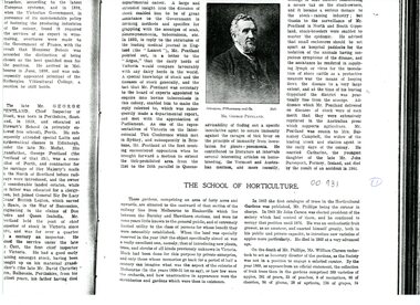
Article - Photocopy, The Cyclopedia of Victoria, The School of Horticulture, 1897-1908
... ...southern district victoria...3 pages of photocopy from Cyclopedia of Victoria on The School of Horticulture. It includes two photographs 1. a young orchard Southern District 2. ...University of Melbourne, Burnley Campus Archives 500 Yarra Boulevard Richmond melbourne Cyclopedia of Victoria on The School of Horticulture cyclopedia of victoria school of horticulture southern district victoria orchard charles bogue luffman luffmann history of burnley 3 pages of photocopy from Cyclopedia of Victoria on The School of Horticulture. ...Cyclopedia of Victoria on The School of Horticulture3 pages of photocopy from Cyclopedia of Victoria on The School of Horticulture. It includes two photographs 1. a young orchard Southern District 2. Cultivating an orchard. Early history.cyclopedia of victoria, school of horticulture, southern district victoria, orchard, charles bogue luffman, luffmann, history of burnley -
 Warrnambool and District Historical Society Inc.
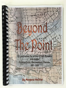
Booklet, Beyond the Point, 2007
... Southern Right Whales return to this beach each year and the females calve and remain up to three months at this beach, making it an important ‘whale nursery’. john logan and mary gardner hopkins point logans beach tooram history of warrnambool Front Cover: ‘Beyond the Point, 150 years since the arrival of Irish ancestor, John Logan, Hopkins Point, Warrnambool, Victoria, 1857-2007, by Margaret McOrist’. This is a soft cover book with black plastic ring binding and clear plastic sheets covering the front and back paper covers. The front cover has a reproduction of an 1891 map of Warrnambool and district ...This book was written in 2007 by Margaret McOrist to mark the 150th anniversary of the arrival in the Warrnambool area of John Logan. It is a sequel to a 1991 book, ‘Clotted Cream and Mangels’ which told the story of John Logan and his wife Mary Gardner. They lived at Hopkins Point, Warrnambool and the book, ‘Beyond the Point’ tells the story of the Logan descendants. When the farm land was sub-divided and sold the nearby beach was named ‘Logans Beach’. This book is of considerable interest as it tells the story of the descendants of important early settlers, John Logan and Mary Gardner. The area where they first settled is now of major interest as Logans Beach (named for the Logan family) is the well-known whale watching area. Southern Right Whales return to this beach each year and the females calve and remain up to three months at this beach, making it an important ‘whale nursery’. This is a soft cover book with black plastic ring binding and clear plastic sheets covering the front and back paper covers. The front cover has a reproduction of an 1891 map of Warrnambool and district with the title of the book and other information superimposed on the map. The back cover is black. The book has 101 pages and contains information on the Logan families who lived at Tooram in Allansford and their descendants. There are many black and white and colour photographs, diagrams, maps and family trees. Front Cover: ‘Beyond the Point, 150 years since the arrival of Irish ancestor, John Logan, Hopkins Point, Warrnambool, Victoria, 1857-2007, by Margaret McOrist’. john logan and mary gardner, hopkins point, logans beach, tooram, history of warrnambool -
 Warrnambool and District Historical Society Inc.
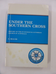
Book, Lutheran Publishing House et al, Under the Southern Cross: History of the Evangelical Lutheran Church of Australia, 1985
... Victoria. It covers the period 1847-1947. As a history of the Lutheran Church in Australia, it contains much information which would be of interest to the Lutheran congregation of the district. warrnambool lutheran church evangelical lutheran church of australia alfred brauer A comprehensive history of the Evangelical Lutheran Church of Australia Author , A Brauer. Small card pasted inside front cover " M J Both Allansford." White soft cover with blue banner on front and back, in which is the title and authors name.456 pages with index. Under the Southern ...A comprehensive history of the Evangelical Lutheran Church of AustraliaWhite soft cover with blue banner on front and back, in which is the title and authors name.456 pages with index.non-fictionA comprehensive history of the Evangelical Lutheran Church of Australiawarrnambool, lutheran church, evangelical lutheran church of australia, alfred brauer -
 Warrnambool and District Historical Society Inc.
Candle Holder, 1930s
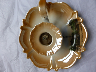
... Warrnambool and District Historical Society Inc. 2 Gilles Street (south of Merri St) Warrnambool great-ocean-road This is a china candle holder which is a souvenir of Warrnambool with an image on the item of the Warrnambool War Memorial. Czechoslovakia was established as a country in 1918 and began to export china goods in the 1920s and 30s when the label ‘Victoria China’ became well known. The Warrnambool War Memorial at the southern ...This is a china candle holder which is a souvenir of Warrnambool with an image on the item of the Warrnambool War Memorial. Czechoslovakia was established as a country in 1918 and began to export china goods in the 1920s and 30s when the label ‘Victoria China’ became well known. The Warrnambool War Memorial at the southern end of Liebig Street was unveiled and dedicated in 1926. It was designed by John King, the Headmaster of the Warrnambool Technical School and erected by the local stonemasons, Wooles and Carpenter. This candle holder is of some interest as an example of the tourist souvenirs that were popular in Warrnambool pre-World War Two. This is a china candle holder with a circular base in brown-orange and white tonings and a fluted edge. The candle holding section is also circular with the same colour tonings and a slightly fluted edge. Inside this are the hardened remains of a candle. The base has a handle attached. On one edge of the base there is a colour image of the Warrnambool War Memorial. The maker’s name at the back has a crown symbol. ‘Soldier’s (sic) Memorial, Warrnambool’ ‘Victoria China, Czechoslovakia’ victoria china czechoslovakia, warrnambool war memorial, history of warrnambool -
 Victoria Police Museum
Police Stations (Apollo Bay)
... Victoria. It is situated on the eastern side of Cape Otway, along the edge of the Barham River and on the Great Ocean Road, in the Colac Otway Shire. The original township was surveyed in 1853 and named Middleton. In 1881 the town was renamed Krambruk which was changed to Apollo Bay in 1898. The Krambruk Police Station was opened on 7 March 1888 in the Southern District...Victoria. It is situated on the eastern side of Cape Otway, along the edge of the Barham River and on the Great Ocean Road, in the Colac Otway Shire. The original township was surveyed in 1853 and named Middleton. In 1881 the town was renamed Krambruk which was changed to Apollo Bay in 1898. The Krambruk Police Station was opened on 7 March 1888 in the Southern District ...Apollo Bay is a coastal town in southwestern Victoria. It is situated on the eastern side of Cape Otway, along the edge of the Barham River and on the Great Ocean Road, in the Colac Otway Shire. The original township was surveyed in 1853 and named Middleton. In 1881 the town was renamed Krambruk which was changed to Apollo Bay in 1898. The Krambruk Police Station was opened on 7 March 1888 in the Southern District on land opposite the site of the current Mechanics' Institute and changed its name to the Apollo Bay Police Station on 1 September 1990. It came under the Barwon District in 1948 and "Lima" Western District from 4 March 1990. In 1930 the police station was located to 29 Nelson Street. It was a seven-roomed weather-board dwelling on three-quarters of an acre of land. It consisted of six rooms of pine, lined and painted; one pantry; one bathroom and wash-house; one hall; one office and one W.C.. There was stabling for one horse and one cell for prisoners. It was staffed by one Mounted Constable. In the early 1970s land was acquired at 31 Nelson Street and a new police station was constructed. This was a three-roomed brick building with a cell block at the rear. By the time it closed in 2005 it had been extended twice. On 17 November 2006 the current Apollo Bay Police Station opened in its current location at 35a Nelson Street, on the corner of Cartwight Street). Outside the peak summer season, the station is open 16 hours per day and staffed by one sergeant and five other members. 3 black & white photos and 2 coloured photospolice stations; apollo bay police station -
 Orbost & District Historical Society
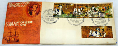
first day cover, Australia Post, April 1970
... Orbost & District Historical Society Ruskin Street Orbost gippsland The Point Hicks cancel was used 8,269 times on the commemorative covers dated 20th April 1970. The first day cover commemorates the bicentenary of Cook's sighting of Point Hicks.When sailing along the coast of what is today southern Victoria, Cook recorded in his journal in April 1770 that he had named "The Southernmost Point of land we had in sight as Point Hicks, because Leiut Hicks, was the first who discoverd this land." ...The Point Hicks cancel was used 8,269 times on the commemorative covers dated 20th April 1970. The first day cover commemorates the bicentenary of Cook's sighting of Point Hicks.When sailing along the coast of what is today southern Victoria, Cook recorded in his journal in April 1770 that he had named "The Southernmost Point of land we had in sight as Point Hicks, because Leiut Hicks, was the first who discoverd this land." This was the first European name recorded during that Endeavour voyage to be applied to a feature on the east coast of Australia. There is no longer a post office at Point Hicks and was possibly a temporary one used only for this issue.A first day issue envelope with stamps. Produced to commemorate the sighting of Point Hicks by Captain James Cook 0n 20 April 1770. It is a large cover with a strip of 5x 5c & a single 30c stamps. first-day-cover cook-james stamps philately point-hicks -
 Lara RSL Sub Branch
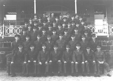
79th Fighter Squadron, Wooloomanata
... Victoria. It was a Spitfire Squadron and used Wooloomanata as a training base before flying. It was disbanded 20th October, 1945. Of national Significance as a Spitfire Squadron training camp in Lara Districts during WW2 79th fighter squadron raaf wooloomanata spitfire world war 2 ww2 peter anderson southern command training school 15 course 18th april 1943 On the back of the photo is "No:15 Course 18th April 1943 on the steps of Wooloomanata Homestead Southern Side". ...The 79th Fighter Squadron was initially formed at Laverton on the 26th April, 1943 under the command of flying ace Squadron Leader Alan Rawlinson, but within seven days moved to Wooloomanata Homestead on the Geelong-Bacchus Marsh Rd, No 1580 in Victoria. It was a Spitfire Squadron and used Wooloomanata as a training base before flying. It was disbanded 20th October, 1945.Of national Significance as a Spitfire Squadron training camp in Lara Districts during WW2Glossy photo and A4 documentOn the back of the photo is "No:15 Course 18th April 1943 on the steps of Wooloomanata Homestead Southern Side". On the bottom is a list of the names of those in the photo. Left to Right Rear Row: Maj. K. Ewen, Capt. N.F. Attree, Capt. C.N. Bucknell, Capt. J.L. McKenzie, Capt. C.D. Seabrook, Lt. W.G. Foley. Second row from rear: Maj. C. Dumble, Capt. A. Tavener, Maj. F. Langford, Maj. T.A.R. Cleave, Capt. M.D. Waller, Capt. J.B. Ainslie, Capt. G.M.Taylor. Third row from rear: Capt. E.K. Jennings, Lt. J.H. Loxton, Capt. D.J. Breheny, Lt. R.V. Stephens, Capt J.W.D. Cornell, Maj. C.A. Ricketts, Lt. A.R. Creswick. Fourth row from rear: Lt. W. Ruthven (V.C.), Capt. R.C. Tomkins, Capt. R.J.Bermingham, Maj. A.E. Arnott, Capt. L.S. Ralton, Maj. F.L. Edmunds, Capt. W.E. Paterson. Fifth row from rear: Maj. H.W. Stockwell, Capt. C.A. Ferry, Maj. A.C. Jennings, Capt. W.L. Hart, Maj. R.R. Marston, Capt. R.A. Cameron, Capt. R.W.M. Page. Sixth Row from rear: Lt. A.E. Pizzy, Capt. A.G. Yungman, Maj.T.G. Court, Maj. J.B. Chapman, Maj. H.F. Gough, Maj. P.L. Barbour, Maj. H.M. Heward, Maj. E.C. Nolte. Front Row: Lt. G.H. Rowden, Capt. C.J.F. Pollett, Maj. A.E.Bunbury, Lt-Col. E.W. Bundey, Major W.A. Cronk, Capt. B.V. Eames, Lt. N.D. Anderson, Maj. C.A. Lotherington. Absent: Lt. R.R. Webster, Lt. R.B. Blackwell The A4 is a written description of a brief history of the 79th Fighter Squadron79th fighter squadron, raaf, wooloomanata, spitfire, world war 2, ww2, peter anderson, southern command training school, 15 course 18th april 1943 -
 Glen Eira Historical Society
Document - Watts, Thomas
... SOUTHERN CROSS newspaper, dated 18th June 1986 Photocopy of photograph, date and photographer unknown, of Thomas Watts and his daughter Kate Two page document describing the papers of Thomas Watts held at the State Library of Victoria. A brief list of documents held at the library is included. Watts Thomas Architect Orrong Road House GLENHUNTLY ST MARYS Glenhuntly Road Rosstown Sugar Works School Caulfield Common School Justice of the Peace Watts Kate Armstrong (Nee Watts) Mrs J.A. Local Government Road Districts ...This file contains various information on architect Thomas Watts who resided at GLENHUNTLY. It includes a photocopied entry on Watts contained in Sutherland VICTORIA AND ITS METROPOLIS, annotated hand-written entries from a rates book on ownership of GLENHUNTLY, and hand-written note of an entry in THE ARGUS dated 26th July 1913 about Watts, a pencilled card for Watts and a photocopy of an article on the property GLENHUNTLY in THE SOUTHERN CROSS newspaper, dated 18th June 1986 Photocopy of photograph, date and photographer unknown, of Thomas Watts and his daughter Kate Two page document describing the papers of Thomas Watts held at the State Library of Victoria. A brief list of documents held at the library is included.watts thomas architect, orrong road, house, glenhuntly st marys, glenhuntly road, rosstown sugar works, school, caulfield common school, justice of the peace, watts kate, armstrong (nee watts) mrs j.a., local government, road districts, caulfield roads district, caulfield shire council, shire president, watts james salter, thomas watts and son, glen eira road, kooyong road, edenthorpe estate, watts estate, watts helen k -
 Phillip Island and District Historical Society Inc.
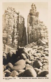
Sepia Photograph, 1920's
... Phillip Island and District Historical Society Inc. phillip-island-and-the-bass-coast This album was presented to the Earl of Stradbroke by the Fathers of Soldiers & Returned Soldiers 16/2/1923. Pink granite outcrop on southern tip of Cape Woolamai. phillip island cape woolamai pink granite earl of stradbroke Rose Series P678. The Pinnacles, Cape Woolamai, Phillip Is., Victoria ...This album was presented to the Earl of Stradbroke by the Fathers of Soldiers & Returned Soldiers 16/2/1923. Pink granite outcrop on southern tip of Cape Woolamai.The Pinnacles - a granite outcrop on Cape WoolamaiRose Series P678. The Pinnacles, Cape Woolamai, Phillip Is., Victoriaphillip island, cape woolamai, pink granite, earl of stradbroke -
 Phillip Island and District Historical Society Inc.
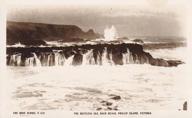
Photograph, Southern Coastline of Phillip Island, c 1926
... Phillip Island and District Historical Society Inc. phillip-island-and-the-bass-coast local history postcards back beach phillip island sepia photograph ian reiher coastline The Rose Series. P 670 The restless sea, Back Beach, Phillip Island, Victoria Sepia Postcard of the southern ...Sepia Postcard of the southern coastline of Phillip Island The Rose Series P 670The Rose Series. P 670 The restless sea, Back Beach, Phillip Island, Victorialocal history, postcards, back beach, phillip island, sepia photograph, ian reiher, coastline -
 Phillip Island and District Historical Society Inc.
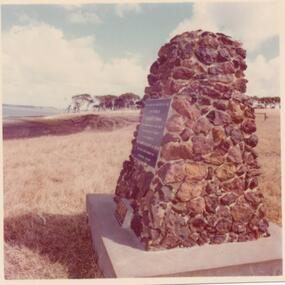
Photograph, 1978/9
... District Historical Society Inc. phillip-island-and-the-bass-coast The Cairn was erected to commemorate the sowing of the first wheat in Victoria by Liet. Grant. It was erected in 1968 during the ownership of the Island by Miss Campbell who inherited it from Dr. Jenkins. local history photographs buildings - historical rural industry coloured photograph john cook churchill island churchill island cairn Coloured photograph showing a cairn on the southern part of Churchill Island Photograph ...The Cairn was erected to commemorate the sowing of the first wheat in Victoria by Liet. Grant. It was erected in 1968 during the ownership of the Island by Miss Campbell who inherited it from Dr. Jenkins.Coloured photograph showing a cairn on the southern part of Churchill Islandlocal history, photographs, buildings - historical, rural industry, coloured photograph, john cook, churchill island, churchill island cairn -
 Eltham District Historical Society Inc
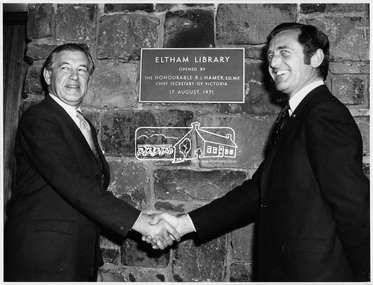
Photograph, Opening of Eltham Library, 17 Aug 1971
... District Historical Society Inc 728 Main Rd Eltham melbourne Official opening of Eltham Library; The Hon. Rupert. J. Hamer, E.D., M.P. (left) and Cr. G.C. Dreverman (right), 17 August 1971, in front of a plaque reading "Eltham Library opened by the Honourable R. J. Hamer E.D., M.P. Chief Secretary of Victoria, 17 August 1971" on the exterior bluestone wall. The Eltham Branch of the Heidelberg Regional Library Service was opened on 17 August 1971 by Victoria’s Chief Secretary R. J. Hamer. The library was designed by the firm Leith and Bartlett and was the southern ...Official opening of Eltham Library; The Hon. Rupert. J. Hamer, E.D., M.P. (left) and Cr. G.C. Dreverman (right), 17 August 1971, in front of a plaque reading "Eltham Library opened by the Honourable R. J. Hamer E.D., M.P. Chief Secretary of Victoria, 17 August 1971" on the exterior bluestone wall. The Eltham Branch of the Heidelberg Regional Library Service was opened on 17 August 1971 by Victoria’s Chief Secretary R. J. Hamer. The library was designed by the firm Leith and Bartlett and was the southern wing of the Shire of Eltham Offices in Main Road Eltham. Visitors entered a “book plaza” which embodies the display techniques of a bookshop. Through this area was located a quieter area for reference and the more “purposeful” reader. The library was opened as part of the Shire of Eltham’s centenary celebrations. The library and Shire Offices were demolished exactly 25 years later in 1996. The current library was opened in 1994. This photo forms part of a collection of photographs gathered by the Shire of Eltham for their centenary project book, "Pioneers and Painters: 100 years of the Shire of Eltham" by Alan Marshall (1971). The collection of over 500 images is held in partnership between Eltham District Historical Society and Yarra Plenty Regional Library (Eltham Library) and is now formally known as 'The Shire of Eltham Pioneers Photograph Collection.' It is significant in being the first community sourced collection representing the places and people of the Shire's first one hundred years.Digital imagesepp, shire of eltham pioneers photograph collection, shire of eltham, shire of eltham centenary, eltham library, opening day, cr. g.c. dreverman, the hon. r.j. hamer -
 Eltham District Historical Society Inc
Photograph, Opening of Eltham Library, 17 Aug 1971
... District Historical Society Inc 728 Main Rd Eltham melbourne Opening of Eltham Library by The Hon. R.J. Hamer, E.D., M.P. (right) and Cr. G.C. Dreverman. The Eltham Branch of the Heidelberg Regional Library Service was opened on 17 August 1971 by Victoria’s Chief Secretary R. J. Hamer. The library was designed by the firm Leith and Bartlett and was the southern ...Opening of Eltham Library by The Hon. R.J. Hamer, E.D., M.P. (right) and Cr. G.C. Dreverman. The Eltham Branch of the Heidelberg Regional Library Service was opened on 17 August 1971 by Victoria’s Chief Secretary R. J. Hamer. The library was designed by the firm Leith and Bartlett and was the southern wing of the Shire of Eltham Offices in Main Road Eltham. Visitors entered a “book plaza” which embodies the display techniques of a bookshop. Through this area was located a quieter area for reference and the more “purposeful” reader. The library was opened as part of the Shire of Eltham’s centenary celebrations. The library and Shire Offices were demolished exactly 25 years later in 1996. The current library was opened in 1994.This photo forms part of a collection of photographs gathered by the Shire of Eltham for their centenary project book, "Pioneers and Painters: 100 years of the Shire of Eltham" by Alan Marshall (1971). The collection of over 500 images is held in partnership between Eltham District Historical Society and Yarra Plenty Regional Library (Eltham Library) and is now formally known as 'The Shire of Eltham Pioneers Photograph Collection.' It is significant in being the first community sourced collection representing the places and people of the Shire's first one hundred years.Digital imagesepp, shire of eltham pioneers photograph collection, shire of eltham, shire of eltham centenary, eltham library, opening day, cr. g.c. dreverman, the hon. r.j. hamer, rupert hamer -
 Eltham District Historical Society Inc
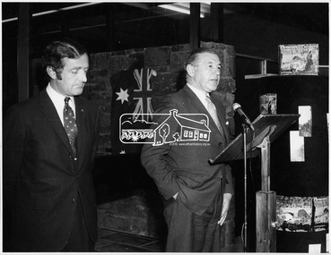
Photograph, Opening of Eltham Library, 17 Aug 1971
... District Historical Society Inc 728 Main Rd Eltham melbourne Cr. G. C. Dreverman J.P. and President of Eltham Shire Council gives a speech at the opening of the Eltham Library in August 1971. Cr Dreverman was a Councillor for the Central Riding of the Shire of Eltham since 1966. The Eltham Branch of the Heidelberg Regional Library Service was opened on 17 August 1971 by Victoria’s Chief Secretary R. J. Hamer. The library was designed by the firm Leith and Bartlett and was the southern ...Cr. G. C. Dreverman J.P. and President of Eltham Shire Council gives a speech at the opening of the Eltham Library in August 1971. Cr Dreverman was a Councillor for the Central Riding of the Shire of Eltham since 1966. The Eltham Branch of the Heidelberg Regional Library Service was opened on 17 August 1971 by Victoria’s Chief Secretary R. J. Hamer. The library was designed by the firm Leith and Bartlett and was the southern wing of the Shire of Eltham Offices in Main Road Eltham. Visitors entered a “book plaza” which embodies the display techniques of a bookshop. Through this area was located a quieter area for reference and the more “purposeful” reader. The library was opened as part of the Shire of Eltham’s centenary celebrations. The library and Shire Offices were demolished exactly 25 years later in 1996. The current library was opened in 1994.This photo forms part of a collection of photographs gathered by the Shire of Eltham for their centenary project book, "Pioneers and Painters: 100 years of the Shire of Eltham" by Alan Marshall (1971). The collection of over 500 images is held in partnership between Eltham District Historical Society and Yarra Plenty Regional Library (Eltham Library) and is now formally known as 'The Shire of Eltham Pioneers Photograph Collection.' It is significant in being the first community sourced collection representing the places and people of the Shire's first one hundred years.Digital imagesepp, shire of eltham pioneers photograph collection, shire of eltham, shire of eltham centenary, eltham library, opening day, cr. g.c. dreverman -
 Eltham District Historical Society Inc
Photograph, Opening of Eltham Library, 17 Aug 1971
... Eltham District Historical Society Inc 728 Main Rd Eltham melbourne The architect of Eltham's new library, Harold Bartlett of Messrs Leith & Bartlett Pty Ltd at the opening of the Eltham Library in 1971. The Eltham Branch of the Heidelberg Regional Library Service was opened on 17 August 1971 by Victoria’s Chief Secretary R. J. Hamer. The library was designed by the firm Leith and Bartlett and was the southern ...The architect of Eltham's new library, Harold Bartlett of Messrs Leith & Bartlett Pty Ltd at the opening of the Eltham Library in 1971. The Eltham Branch of the Heidelberg Regional Library Service was opened on 17 August 1971 by Victoria’s Chief Secretary R. J. Hamer. The library was designed by the firm Leith and Bartlett and was the southern wing of the Shire of Eltham Offices in Main Road Eltham. Visitors entered a “book plaza” which embodies the display techniques of a bookshop. Through this area was located a quieter area for reference and the more “purposeful” reader. The library was opened as part of the Shire of Eltham’s centenary celebrations. Diamond Valley News, 24 August 1971 Wisdom of Solomon. "The architect of Eltham's new library, Mr Harold Bartett, at the opening of the library last week said: " Decisions to build such cultural builidngs as this with so little money and so many other basic items on the priority list are not taken without long hours of thoughtful debate demanding the wisdom of Solomon, the knowledge of a Moses, the business acumen of a money changer, the tender heart of a Rachael, the couriage of a David and last, but not least, the armour of a centurion." Thus, he described the attributes required in a municipal councillor. Mr Bartlett is a former councillor and is still honorary planner for the shire." H. E. Bartlett was on the Shire of Eltham Council 1954-1961. The library and Shire Offices were demolished exactly 25 years later in 1996. This photo forms part of a collection of photographs gathered by the Shire of Eltham for their centenary project book, "Pioneers and Painters: 100 years of the Shire of Eltham" by Alan Marshall (1971). The collection of over 500 images is held in partnership between Eltham District Historical Society and Yarra Plenty Regional Library (Eltham Library) and is now formally known as 'The Shire of Eltham Pioneers Photograph Collection.' It is significant in being the first community sourced collection representing the places and people of the Shire's first one hundred years.Digital imagesepp, shire of eltham pioneers photograph collection, shire of eltham, shire of eltham centenary, eltham library, opening day, h. bartlett, harold bartlett, sppech -
 Bendigo Historical Society Inc.
Certificate - Merle Bush Trefoil Guild
... THE MERLE BUSH TREFOIL GUILD BENDIGO - OF THE NORTH CENTRAL REGION BENDIGO SOUTHERN DIVISION BENDIGO CENTRAL DISTRICT - IN THE STATE OF VICTORIA- WAS FORMED ON THE 12-4-1981. ...Victoria, she received her Captain's Warrant on 12th December 1922. Girl Guides Guiding Merle Bush Trefoil Guild Certificate with Yellow external border. THE MERLE BUSH TREFOIL GUILD BENDIGO - OF THE NORTH CENTRAL REGION BENDIGO SOUTHERN DIVISION BENDIGO CENTRAL DISTRICT - IN THE STATE OF VICTORIA- WAS FORMED ON THE 12-4-1981. ...The first meeting of the 1st Bendigo Guides was held by Miss Merle Bush on the 22nd of August 1922 in the St Paul' School Room. Twelve girls were present. Miss Bush was given permission to open the Company by Miss R. Hamilton, State Secretary for Victoria, she received her Captain's Warrant on 12th December 1922. Certificate with Yellow external border. THE MERLE BUSH TREFOIL GUILD BENDIGO - OF THE NORTH CENTRAL REGION BENDIGO SOUTHERN DIVISION BENDIGO CENTRAL DISTRICT - IN THE STATE OF VICTORIA- WAS FORMED ON THE 12-4-1981. REGISTERED ON THE 18-6-1981. girl guides, guiding, merle bush, trefoil guild -
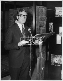
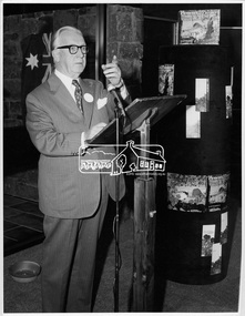
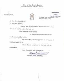 Ringwood and District Historical Society
Letter, Order of the Secret Monitor, Moorabbin, Victoria - Collection of Masonic Degrees and Correspondence maintained by Aird family of Ringwood, Victoria
... Letter dated 26th October, 1964 from District Grand Recorder, Order of the Secret Monitor, District Grand Conclave of Southern Australia, 12 Dane Road, Moorabbin, Victoria, confering R.Wor. ...Ringwood and District Historical Society 125A Warrandyte Road Ringwood North melbourne Letter dated 26th October, 1964 from District Grand Recorder, Order of the Secret Monitor, District Grand Conclave of Southern Australia, 12 Dane Road, Moorabbin, Victoria, confering R.Wor. ...Letter dated 26th October, 1964 from District Grand Recorder, Order of the Secret Monitor, District Grand Conclave of Southern Australia, 12 Dane Road, Moorabbin, Victoria, confering R.Wor. Bro. A.J.B. Aird with the rank of Past District Grand Visitor in the District Grand Conclave of Southern Australia on payment of £3-3-0 fee. -
 Ringwood and District Historical Society
Mixed media - Video, RDHS Guest Speaker Presentation - "South Side Story - Maroondah Hwy, Wantirna Road to New Street" - Richard Carter
... Ringwood and District Historical Society 125A Warrandyte Road Ringwood North melbourne Presenter: Past-President of RDHS, Richard Carter, is the guru when it comes to researching properties. South Side Story examines the often forgotten - but important - part of Ringwood from Wantirna Road to Olive Grove on the southern side of Maroondah Highway, Ringwood, Victoria. ...Digitised video (3.19GB) Duration: 75 minutes. Recorded May, 2023 (Video is available for viewing at Ringwood & District Historical Society Archives by appointment)Presenter: Past-President of RDHS, Richard Carter, is the guru when it comes to researching properties. South Side Story examines the often forgotten - but important - part of Ringwood from Wantirna Road to Olive Grove on the southern side of Maroondah Highway, Ringwood, Victoria. -
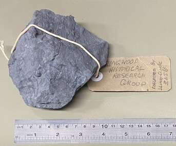 Ringwood and District Historical Society
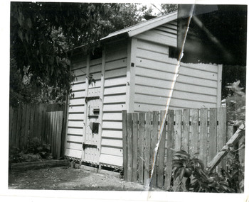
Geological specimen, Collected by J. Lundy-Clarke, Sample of Metamorphic Rock from Hubbard Park, Ringwood, Victoria, Found 1979
... District Historical Society 125A Warrandyte Road Ringwood North melbourne Collected by J. Lundy-Clarke, Ringwood Historical Research Group. Sample of metamorphic rock encountered by M.M.B.W. gang of tunnellers boring for a sewer drain through a geological fault-dyke along the southern boundary of Hubbard Park. The hole for 900 feet of 12.5 inch pipe took 6 months to bore from Oct-1979 to May-1980. Sample of Metamorphic Rock from Hubbard Park, Ringwood, Victoria ...Sample of metamorphic rock encountered by M.M.B.W. gang of tunnellers boring for a sewer drain through a geological fault-dyke along the southern boundary of Hubbard Park. The hole for 900 feet of 12.5 inch pipe took 6 months to bore from Oct-1979 to May-1980. Collected by J. Lundy-Clarke, Ringwood Historical Research Group. -
 Orbost & District Historical Society
black and white photograph, first half 20th century
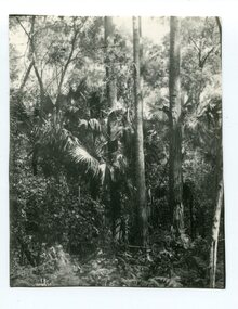
... Orbost & District Historical Society Ruskin Street Orbost gippsland Livistona australis - the Cabbage Tree Palm, is a fan palm that grows naturally in the lowland forest and swamps of southern Queensland and along the east coast of Australia and it occurs further south than any other Australian palm species. It is the only palm that is found naturally in Victoria ...Livistona australis - the Cabbage Tree Palm, is a fan palm that grows naturally in the lowland forest and swamps of southern Queensland and along the east coast of Australia and it occurs further south than any other Australian palm species. It is the only palm that is found naturally in Victoria. The early settlers supplemented their meagre rations with the hearts of the Cabbage Tree Palm.This is the southernmost stand of Cabbage Tree Palms in Australia and the only location in Victoria where these palms grow naturally. This is a pictorial record of a rare native Australian palm.A black / white photograph of small palm trees in a dense bush surrounding.cabbage-tree-palm-east-gippsland -
 Orbost & District Historical Society
black and white photograph, Vogt. W.S, first half 20th century
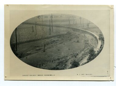
... District Historical Society Ruskin Street Orbost gippsland In 1912 work was underrway on the Bairnsdale to Orbost railway. It was opened on April 10 1916. The two bridges on the railway viaduct, which crosses the Snowy River floodplain at Orbost, were built from local Southern Mahogany. The bridge on the Bairnsdale end (770m) is now the longest in Victoria ...In 1912 work was underrway on the Bairnsdale to Orbost railway. It was opened on April 10 1916. The two bridges on the railway viaduct, which crosses the Snowy River floodplain at Orbost, were built from local Southern Mahogany. The bridge on the Bairnsdale end (770m) is now the longest in Victoria. (info. Helen Martin)This item is associated with the history of the Orbost-Bairnsdale railway line and therefore reflects the role that the rail line played in the social and economic history of Orbost.A black / white photograph, oval-shaped on white background. It is of the railway viaduct across the flats at Orbost,.photo caption -"ORBOST RAILWAY BRIDGE, NEWMERELLA E. S. Vogt, Bairnsdale"newmerella orbost-viaduct east-gipsland-railway -
 Orbost & District Historical Society
black and white photograph, Rose Stereograph Company, first half 20th century
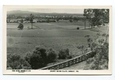
... Orbost & District Historical Society Ruskin Street Orbost gippsland The two bridges on the railway viaduct, which crosses the Snowy River floodplain at Orbost, were built from local Southern Mahogany. The bridge on the Bairnsdale end (770m) is now the longest in Victoria ...The two bridges on the railway viaduct, which crosses the Snowy River floodplain at Orbost, were built from local Southern Mahogany. The bridge on the Bairnsdale end (770m) is now the longest in Victoria. Despite various attempts to extend the line, the station stayed on the western side of the Snowy River. (info. Helen Martin)This item is associated with the history of the Orbost-Bairnsdale railway line and therefore reflects the role that the rail line played in the social and economic history of Orbost.A black / white photograph / postcard of the Orbost township in the background and the railway viaduct over the flats in the foreground.photo caption - The Rose Series P.479 copywright SNOWY RIVER FLATS, ORBOST, VIC"east-gippsland-railway orbost-viaduct -
 Sunshine and District Historical Society Incorporated
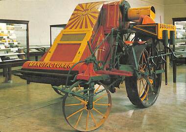
Postcard - The McKay Harvester, 1906 Postcard
... District Historical Society Incorporated The Hunt Club Community Arts Centre, 775 Ballarat Road, Deer Park 3023. Brimbank Library, 301 Hampshire Road, Sunshine 3020. melbourne The H.V. McKay factory— known as the Sunshine Harvester Works, was a landmark of Australian industrial history and a cornerstone of Sunshine, Victoria’s development. Founded by Hugh Victor McKay, inventor of the Sunshine Harvester, which revolutionized wheat harvesting in Australia. Originally based in Ballarat, McKay moved operations to Braybrook Junction in 1906, renaming it Sunshine Harvester Works after his flagship product. The factory became the largest industrial enterprise in the Southern ...The H.V. McKay factory— known as the Sunshine Harvester Works, was a landmark of Australian industrial history and a cornerstone of Sunshine, Victoria’s development. Founded by Hugh Victor McKay, inventor of the Sunshine Harvester, which revolutionized wheat harvesting in Australia. Originally based in Ballarat, McKay moved operations to Braybrook Junction in 1906, renaming it Sunshine Harvester Works after his flagship product. The factory became the largest industrial enterprise in the Southern Hemisphere by the 1920s, covering over 30 acres and employing nearly 3,000 workers. The McKay Harvester 1906 was one of the first machines in the world to strip, thresh and winnow grain ready for bagging. On Back: The McKay Harvester 1906. The McKay Harvester was one of the first machines in the world to strip, thresh and winnow grain ready for bagging. From a small beginning in 1884, Hugh Victor McKay became the largest manufacturer of harvesters and other agricultural machinery in Australiah.v. mckays, farm machinery -
 Sunshine and District Historical Society Incorporated
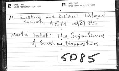
Audio - Sunshine and District Historical Society Annual General Meeting 1995 Audio Tape, 20/8/1995
... Victoria founded by industrialist HV McKay, It was famous for producing the 'Sunshine Harvester' a combine harvester that could strip, thresh and winnow grain in one operation. The factory was also a huge industrial complex that contributed to the development of the City of Sunshine, and at its peak was the largest manufacturing facility in the southern hemisphere. Martin Hallett Sunshine Harvester Works At Sunshine and District ...Martin Hallett was a museum curator and Deputy Chief Executive of Museums Victoria. The Sunshine Harvester Works was an agricultural equipment factory in Sunshine, Victoria founded by industrialist HV McKay, It was famous for producing the 'Sunshine Harvester' a combine harvester that could strip, thresh and winnow grain in one operation. The factory was also a huge industrial complex that contributed to the development of the City of Sunshine, and at its peak was the largest manufacturing facility in the southern hemisphere.At Sunshine and District Historical Society A.G.M. 20/8/1995 Martin Hallett The significance of Sunshine Harvestersmartin hallett, sunshine harvester works -
 Marysville & District Historical Society
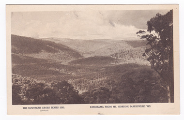
Postcard (item) - Black and white postcard, Rose Stereograph Company, Panorama from Mt. Gordon, Maryvsille, Vic, 1913-1967
... District Historical Society 39 Darwin Street Marysville yarra-valley-and-the-dandenong-ranges A postcard in a series produced by the Rose Stereograph Company in Victoria. An early postcard of the view of Marysville from nearby Mount Gordon. This postcard was produced by the Rose Stereograph Company as a souvenir of Marysville. mount gordon marysville victoria rose stereograph company southern ...A postcard in a series produced by the Rose Stereograph Company in Victoria.An early postcard of the view of Marysville from nearby Mount Gordon. This postcard was produced by the Rose Stereograph Company as a souvenir of Marysville.THE SOUTHERN CROSS SERIES 2293./ COPYRIGHT/ PANORAMA FROM MT. GORDON, MARYSVILLE, VIC. POST CARD. Correspondence/ Addressmount gordon, marysville, victoria, rose stereograph company, southern cross series, 2293, postcard, souvenir -
 Marysville & District Historical Society
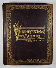
Book - Hardcover book, McCarron, Bird & Co, Victoria and its Metropolis-Past and Present-Volume 2, 1888
... Southern strand/ The glories of our Fatherland/ J.W. Meaden./ Melbourne, 1888. Stamp of the Marysville & District Historical Society Inc/ P.O. Box 22/ Marysville 3779 Hardback. Dark brown cover with the title in gold lettering. There is also a border in gold decorating the outer edge of the front cover. The spine is also decorated in gold along with the title and the volume number. Victoria ...A history of the various colonies and districts of Victoria from the time of the discovery of Australia through until 1888.Hardback. Dark brown cover with the title in gold lettering. There is also a border in gold decorating the outer edge of the front cover. The spine is also decorated in gold along with the title and the volume number.non-fictionA history of the various colonies and districts of Victoria from the time of the discovery of Australia through until 1888.melbourne, victoria, pioneers, colonisation, history, fauna, flora, banking, finance, medicine, western district, south-western district, wimmera district, geelong district, ballarat district, avoca district, coliban district, campase district, loddon district, lower goulburn district, upper goulburn district, ovens district, north-east district, gippsland district, mornington district, westernport district, upper yarra district, evelyn district, bourke district -
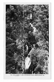
 Marysville & District Historical Society
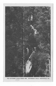
Postcard (item) - Black and white postcard, Rose Stereograph Company, Stevenson Falls, Marysville, Vic, 1930
... District Historical Society 39 Darwin Street Marysville yarra-valley-and-the-dandenong-ranges A postcard in a series produced by the Rose Stereograph Company in Victoria, Australia. A black and white photograph of Steavenson Falls in Marysville in Victoria. The Steavenson Falls is named after the Victorian Assistant Commissioner of Roads and Bridges, John Steavenson, who arrived in Victoria in the early 1860s. This postcard was produced by the Rose Stereograph Company as a souvenir of Marysville. marysville victoria waterfalls stevenson falls steavenson falls southern ...A postcard in a series produced by the Rose Stereograph Company in Victoria, Australia. A black and white photograph of Steavenson Falls in Marysville in Victoria. The Steavenson Falls is named after the Victorian Assistant Commissioner of Roads and Bridges, John Steavenson, who arrived in Victoria in the early 1860s. This postcard was produced by the Rose Stereograph Company as a souvenir of Marysville.POST CARD. Correspondence Addressmarysville, victoria, waterfalls, stevenson falls, steavenson falls, southern cross series, 4990, postcard, souvenir, john steavenson -
 Marysville & District Historical Society
Postcard (item) - Black and white postcard, Rose Stereograph Company, Stevenson Falls, Marysville, Vic, 1930
... District Historical Society 39 Darwin Street Marysville yarra-valley-and-the-dandenong-ranges A postcard in a series produced by the Rose Stereograph Company in Victoria, Australia. A black and white photograph of Steavenson Falls in Marysville in Victoria. The Steavenson Falls is named after the Victorian Assistant Commissioner of Roads and Bridges, John Steavenson, who arrived in Victoria in the early 1860s. This postcard was produced by the Rose Stereograph Company as a souvenir of Marysville. marysville victoria waterfalls stevenson falls steavenson falls southern ...A postcard in a series produced by the Rose Stereograph Company in Victoria, Australia.A black and white photograph of Steavenson Falls in Marysville in Victoria. The Steavenson Falls is named after the Victorian Assistant Commissioner of Roads and Bridges, John Steavenson, who arrived in Victoria in the early 1860s. This postcard was produced by the Rose Stereograph Company as a souvenir of Marysville.POST CARD. Correspondence Addressmarysville, victoria, waterfalls, stevenson falls, steavenson falls, southern cross series, 4990, postcard, souvenir, john steavenson -
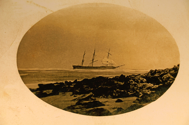 Torquay and District Historical Society
Photograph - Photograph (copy), Joseph H Scammel wreck
... Torquay and District Historical Society 18 Price Street Torquay great-ocean-road Photo shows the Joseph H Scammel stranded on the reef off Point Danger Torquay in 1891 One of the many ships wrecked on the coast of southern Victoria. shipwrecks great ocean road victoria Scammell Collection Sepia photograph, mounted in black frame Joseph H Scammel wreck Photograph Photograph (copy) ...Photo shows the Joseph H Scammel stranded on the reef off Point Danger Torquay in 1891One of the many ships wrecked on the coast of southern Victoria.Sepia photograph, mounted in black frameshipwrecks great ocean road victoria, scammell collection -
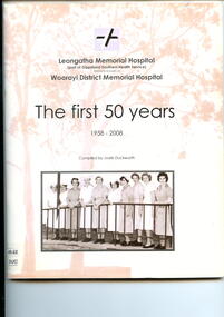 Alfred Hospital Nurses League - Nursing History Collection
Booklet - Illustrated booklet, Jodie Duckworth, Leongatha Memorial Hospital (part of Gippsland Southern Health Service) formerly known as Woorayl District Memorial Hospital: The first 50 years 1958-2008, 2008
... Southern health Service. Of significance to the AHNL as it is the history of another Victorian hospital. The booklet also contains two photographs of Sybil Smith (Alfred graduate 1959) and Dorothy Potter (Alfred Graduate). Leongatha Memorial Hospital Woorayl District Hospital Hospitals-Victoria ...History of the Leongatha Memorial Hospital (formerly known as the Woorayl District Memorial Hospital) from the time one of two private hospitals in Leongatha closed in 1942, and a bush nursing hospital took over the premises. The need for a bigger hospital was recognized and new hospital opened in 1958. The booklet covers development of the hospital up to 2008.Illustrated booklet with white cover. Title and compilers name in black ink on front cover. Also on the front cover is a reproduction of a black and white photograph of nursing staff taken in 1958, as well as the two 'twin' gum trees which mark the site of the memorial rock in the hospital grounds where a number of plaques are located, in sepia/pink ink. The hospital logo of stylized black and white cross on a mauve background are on the front and back cover.non-fictionHistory of the Leongatha Memorial Hospital (formerly known as the Woorayl District Memorial Hospital) from the time one of two private hospitals in Leongatha closed in 1942, and a bush nursing hospital took over the premises. The need for a bigger hospital was recognized and new hospital opened in 1958. The booklet covers development of the hospital up to 2008.leongatha memorial hospital, woorayl district hospital, hospitals-victoria-history, leongatha