Showing 217 items matching stawell road
-
 Halls Gap & Grampians Historical Society
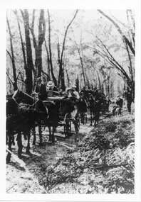
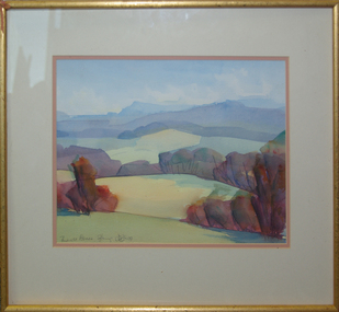
Photograph - B/W, C 1900
... A group of people on the Stawell-Halls Gap road... A group of people on the Stawell-Halls Gap road on their way ...A group of people on the Stawell-Halls Gap road on their way to an outing at the turn of the 19th century.access routes, jinker track, transport, horse drawn -
 Stawell Historical Society Inc
Map, P Jones, Shire of Stawell Roads and Reserves, 1989
... Two Copies (2) map With roads around Stawell. Forests... grampians Map Shire of Stawell Roads and Reserves Two Copies (2) map ...Shows Woodlands Forests & Open WoodlandTwo Copies (2) map With roads around Stawell. Forests Woodlands 2 Very open Woodlands Coloured.Drawn P Jones. May 1989. Last Amended 25 may 1989 -
 Stawell Historical Society Inc
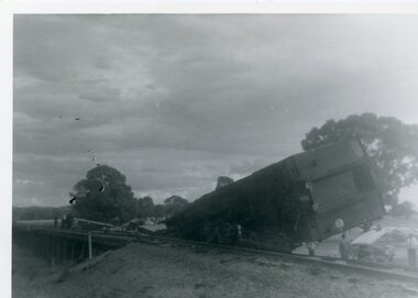
Photograph, Train Derailment near Glenorchy February 1971-- 6 Photos, 1971
... - at the level crossing on the Warracknabeal - Stawell Road. There are 2... - at the level crossing on the Warracknabeal - Stawell Road. There are 2 ...Series of six photographs of Train derailment near Glenorchy February 1971. These Photographs are copies o=from negatives held by the society - Made possible by grant 1991. These photographs taken of a train accident. The Afternoon Passenger Train - at the level crossing on the Warracknabeal - Stawell Road. There are 2 crossings on the road - This crossing is near the Wimmera River Rail Bridge. The cause of the accident - was a collision between a loaded Gravel truck and the passenger train. The Driver of the Truck was killed. 1231-2 B/w Photo of Train Smash near Glenorchy. This photo was donated from the estate of Mr Boothey in 2010, and is almost identical to one in 1231. This Photo is in album 4. B/W Photos of a Train Smash - 1231 The deisel Engine completely derailed off the rail line. 1231-1 showing the derailed rolling stock from another angle. Many onlookers. 1231-2 The Boogie is completely off the carriage 3 Photogrpahsstawell railways transport, glenochy -
 Eltham District Historical Society Inc
Photograph, Fay Bridge, Rosehill Homestead, EDHS Heritage Excursion, 6 July 2019
... . The walk will start at the at the corner of Bonds and Stawell Roads... at the at the corner of Bonds and Stawell Roads, Lower Plenty - EDHS ...July Excursion July 6, 2019 - Exploring Lower Plenty The predominant feature of this walk in the Bonds Road area, Lower Plenty is the large number of magnificent old River Red Gums that line the route. These trees are of the spreading woodland form of this species indicating that they must have been originally growing in a reasonably open setting. The walk also includes parts of the historic Cleveland Estate and the homestead “Rosehill” established by pioneer farmer Henry Stooke. This area was the site of the first recorded European settlement in what was to become the Shire of Eltham when the Willis brothers arrived in the late 1830s. From the southern part of Cleveland Avenue there are extensive views across and along the Yarra Valley. An article on the history of this area was contained in Newsletter edition 201, November 2011. The walk will start at the at the corner of Bonds and Stawell Roads, Lower Plenty - EDHS Newsletter No. 246 June 2019fay bridge collection, 2019-07-06, blackburn bricks, eltham district historical society, heritage excursion, rosehill homestead, lower plenty -
Stawell Historical Society Inc
Geological specimen - Mining, Broken Dimond Drill Pieces
... of Stawell. Found along Darlington Road after drilling to erect...Stawell Historical Society Inc 46 Longfield St Stawell ...Used to drill through the red Iron stone - reefs end of Stawell. Found along Darlington Road after drilling to erect a Power Pole 2X Cylindrical Broken used Dimond Drill - Core Samples, Basalt - granite -
Stawell Historical Society Inc
Map, Borough of Stawell Parish of Stawell and Illawarra 10/06/1903, 10/06/1903
... Department of Lands and Survey Map of Stawell with marked... Map of Stawell with marked roads, allotments, physical ...Department of Lands and Survey Map of Stawell with marked roads, allotments, physical landmarks. Found in Storage at ANZ Bank when the old archive was being cleaned out. Also shows Surveyed but unused roads. Showed where customers lived in StawellPholtolithograph Map - Paper on canvas backingBorough of Stawell. Parish of Stawell and Illawarra. County of Borong. Scale 8 Chains to 1 Inch. Scale 16 Chains to 1 Inch. Red Ink Writing, Purple and Blue.town -
 Stawell Historical Society Inc
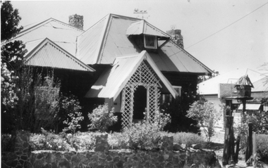
Photograph, Log Cabin c 1930's with Iron roof
... . The home is located in Darlington Road Stawell. The Wharrie family.... The home is located in Darlington Road Stawell. The Wharrie family ...Log Cabin built by Mr. J. Wharrie c 1930’s. Originally the Log cabin had a bark roof. The roof was replaced with iron. The home is located in Darlington Road Stawell. The Wharrie family lived in the cabin for many years during the 1940's and owned a doll factory. Black & white photograph depicting a home built of logs with a lattice porch way, stone chimney's and iron roof. On the iron roof is a weather vane decorated on top by a carriage and 2 horses. The house is set in a garden with a stone fence in the foreground. There are 2 black & white prints one an enlargement of the smaller photograph.stawell dwelling -
 Stawell Historical Society Inc
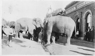
Photograph, Elephants from a Circus at Fraser's Bricklayers Arms Hotel in Barnes Street drinking out of Horse Trough
... the circuses used to be at the Stawell Showgrounds in lake Road now... used to be at the Stawell Showgrounds in lake Road now ...Elephants from a Circus at Fraser's Bricklayers Arms Hotel Barnes Street drinking out of Horse Trough. At that time the circuses used to be at the Stawell Showgrounds in lake Road now the Shire Yards opposite the Brickworks.stawell -
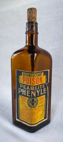 City of Moorabbin Historical Society (Operating the Box Cottage Museum)
Container - Pearlite Phenyle Bottle
Pearlite Phenyle was manufactured by Renown Pearlite Company Pty Ltd, which was formerly known as Pearlite Manufacturing Company. The factory was in 171-177 Stawell Street, Richmond and they manufactured kitchen products essence, Sunflakes - breakfast cereal.4 sided, diamond-shaped amber glass Phenyle bottle with cork stopper and paper label printed in blue, red, and yellow.Disinfectant – Poison – Pearlite Phenyle Poisonous not to be taken Contents 20 Fluid ozs Renown & Pearlite Pty Ltd DIRECTIONS FOR USE 2 teaspoonfuls to 1 pint of water 1 pint to 6 Gallons of water Does not contain more than 3 per cent or less than 2 pre cent or Carbolic or its homologue. Guaranteed to destroy Typhoid Fever Bacillus, 1 part fluid 30 parts water, in 10 minutes. NOTE – Placing the disinfectant in copper vessels or in contact with Alkaline Substances renders it imperative. ANTIDOTE: Epsom or Glauber salts in water. Lime water and olive oil or castor oil (Perlite for Preference) EMBOSED ON BOTTLE: Phenyle with XX’s – poisonous – this bottle is the property of – 2140 STICKER: Sold by Crofts Stores Pty Ltd Branch Store: Hawthorn Road Caulfield. phenyle, bottle, cleaning, disenfectant -
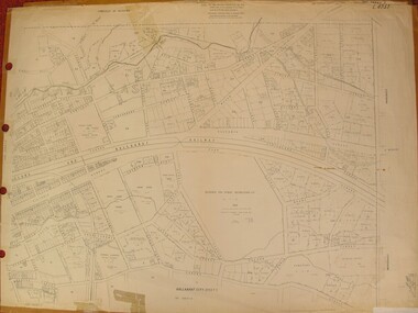 Federation University Historical Collection
Plan, Ballarat East, 1957
Dr George Clendinning and others were trustees of the Church of England (St Paul's) A number of enlargements of the Ballarat East maps. .4) Bakery Hill, Humffray Street, Victoria Street, Ballarat Youth Council .5) Specimen Vale, Victoria Street, Eureka Street, Housing Commission .10) - Tomber Reserve, York Street, Spencer Street, Bennett Street, Wilson Street, Rodier Street, Richard Street, Fussell Street, Turpie Street, Stockade Street, Ballarat Rifle Range Lal La Street, Clayton Street, Eureka Street Sheet 2 - Yarrowee Creek, High Street, Dinney's Dam, Binney Street, Oliver Street, Humffray Street, Morres Street, Finch Street, Scotts Parade, Rice Street, HOrnby Street, Queen Street, Newman street, King Street, Napier Street, Sim Street. Sheet 3 - Russell Square, Victoria Street, Orphan Asylum, Ballarat Orphanage, Lofven Street, Haines Street, Yarrowee Creek, Ching Who Coey, Chinese, Stawell Street, Rice Street, Lane Street, Humffray Street, Nelson Street, Coffield Street, Morres Street, Western Highway, Rodier Street, Scott Parade, Canterbury Street Sheet 4 - Orphan Asylum, Ballarat Orphanage School, Fortune Street, Scotts Parade, Water Street, Ritchie Street, Humffray Street, Brophy Street, Thompson Street, Victoria Street,Humffray Street Church of England Reserve, Strickland Parade. Mount Xavier Recreation Reserve, Charlesworth Street Catholic Church Reserve. Sheet 5 - Western Highway, Mount Street, Fortune Street, Finlay Street, Jones Street, Ryan Street, Water Street, Brandbury Street, Humffray Street. Sheet 6 - Barkly Street, Ebden Street, Grenville Street, Cameron Street, Peel Street, Young Street, Victoria Street, Steinfeld Street, Haymes Street, Bond Street, Anderson Street, Eastwood Street, Mair Street, East Street, Haymes Crescent Sheet 7 - Murphy Street, Queen Street, Dyte Parade, Princes Street, Midland Highway, York Street, Dodds St, Wilson St Otway Street, Specimen vale, King Street, Gray Street, Little Dodds Street, Eureka Street. Sheet 9 - Richards Street, Fussell Street, Stockade Street, Orphan Asylum, Ballarat Orphanage, Elford Street, Russell Street, Ross Street, Charlesworth Street, Lalor Street, Stockade Street, Wilson Street, York Street, Eureka Street Sheet 10 - Eureka Street, York Street, Elford Street, Wilson Street, Mount Street, Turpie Street, Timber Reserve, Mount Xavier Sheet 11 - Yarrowee Creek, Humffray Street, Barkly Street, Morton Street, Cobden Street, Morton Street Wesleyan Church, Pryor Street, Albion Street, Bradshaw Street, Ballarat Woollen Mills, Tannery, Mount Pleasant. Sheet 12 - Magpie Street, Grant Street, Gladstone Street, Cobden Street, Fraser Street, Grenfell Street, Robertson Street, Bond Street, Barkly Street, Vine Street, Sovereign Hill, Ballarat Observatory, Pearce Street, Bond Street. Sheet 13 - Murphy Street, Larter Street, midland Highway, Geelong Road, gales Street, Lal Lal Street, Clayton Street, Dodds Street, Elsworth Street Sheet 14 - Eureka Street, Eureka Stockade Memorial Park, Eureka Stockade Reserve. York Street, Joseph Street, Kline Street, Charlesworth Street, Chamberlain Street, Trevor Street, Belford Street, Queen Street, Murray Street, Eureka Tiles, Orphan Asylum, Ballarat Orphanage. Sheet 18 - Scotts Parade, Stawell Street, Fortune Street, Victoria STreet, Railway Line, Haines Street, Eureka Street, Elford STreet, Brophy Street, York Street, Clayton Street, Elsworth Street, Barkly Street, Humffray Street, Midland Highway, Princes Street ballarat youth council, ballarat east, bakery hill, humffray street, victoria street, st paul's anglican church, humffray street state school -
Federation University Historical Collection
Document, Zelda Martin, Central Victorian Goldmining towns - Boom Towns or Ghost Towns?, c1996
Zelda Martin was a PhD candidate at the University of Melbourne.[.1] 4th item in light blue display book titled Research Approach/Overview of Chapters/Confirmation of Canditure/Chapters1,2,3&4 of proposed thesis. *Twenty-seven page article on Victorian goldfields towns titled: Central Victorian Goldmining Towns - Boom Towns or Ghost Towns. The article was written during the author's PhD study. It outlines the context methodology, and resources and the chapters of the proposed thesis: (1) Central Victorian Goldmining Towns - The Context (2) Contemporary Views of the Factors Necessary for Town Growth (3) Outward Manifestations of Town Growth (4) The Trappings of Government (5-9) The Main Towns and Their Hinterland. [.2] 5th item in Light Blue display book as above item. *Chapter 1 of proposed thesis titled 'Pick, Shovel and Tin Dish Mining.' Covers in Section A: Central Victoria - Pre 1851: Aborigines in Central Victoria, Squatters, and Government. Section B: The years 1851-1854: The Early Gold Rushes, Government Reaction, Township Surveys, Legislation, Town Development, Local Government and Early Settlement. [.3] 6th item in Light Blue display book as above item. *2A of proposed thesis titled 'Contemporary Views of the Factors Necessary for Town Growth'. Similar information to Chapter 1 plus extra re towns and maps. Sections: Introduction, Context of Place - Geographical Towns Listed, The Context of Time - Pre1851 Aborigines, Governance of Port Phillip, The Squatters, The Villages of Central Victorian Highlands, Conclusion, Condensed Version of Chapter2B. [.4] 7th item in Light Blue display book as above item. *Chapter2B of proposed thesis. Sections: Area of Research, Schools, Banks, Newspapers, Progress Association, Town Development - Sandhurst (Bendigo), Ballarat, Castlemaine,, Maryborough, Ararat and Stawell. [.5] 8th item in Light Blue display book as above item. *Chapter 3 of proposed thesis titled 'Outward Manifestations of Town Growth'. Sections: Introduction, Contemporary Writing, Educationalists, The Bankers, The Townsfolk, Current Theory, General Theories of Urban Development, and Conclusion. [.6] 9th item in Light Blue display book as above item. *Chapter 4 of proposed thesis titled 'Trappings of Government' Sections: Introduction, Early Government Attitudes to Mining and Town Development, Law and Order, Township Surveys, Legislation, Local Government, Transport and Communication, The People and Lobbyists. [.7] 10th item in Light Blue display book as above item. *'The Rise and Fall of Central Victorian Goldmining Towns'. Includes a map showing main Goldfields, a table showing towns and villages at two points in time - 1857 and 1871; a Bibliography of Primary and Secondary Sources. [.8] Resource No1. Black display book titled Local Towns 1 : Alma: *Brief history *Directory *Maps Amphitheatre / Mountain Hut: *Brief History Post Office Directory Ararat: *Brief History *Post Office Directory 1869 - Alphabetical Listing by Occupation *Ararat - Prominent Citizens of 1858 *Langi-Morgala Museum Avoca: *Brief History *Excerpts from 'Avoca The Early Years', Margery and Betty Beavis; pg1 - Beginnings; pg11 - The Midas Touch; pg25 - Local Gold Escorts; pg27 - A Town is Born; pg51- The Administration of Justice; pg53 - The Ways of the Law; pg61 - News of the Day; pg65 - A Time to Play; pg72 - Land Ownership *Post Office Directory (Bailliere's) 1869 *Tourism Map and Information of area *Historic Avoca - A 5.5km Tour *Avoca & the Pyrenees Region - information pamphlet Ballarat: *Early History of Ballarat - Ballarat Historical Society, Publication No.1: origin of the name; Ballaarat - the Beginning; Fabulous Yields from the Ballaarat Goldfield; *Streetscape Lydiard Street. *Hand drawn map showing Leigh River, Old Portland Bay Road, plaque on road to Colac; etc. *Newspaper article re 'The Theatre Royal' ( which stood in the vicinity of the current Owen Williams store) - 'The News'15/04/1998 *Article - 'Ballarat's Mechanics' Institute Lives On' Ballarat Courier, 14/09/1985 *Article - Standing the Test of Time' The News 17/11/1993 re The Mechanics Institute & picture of the Reading Room *'Ballarat a Study of a City, Phyllis Reichl, pub. Nelson, 1968; no.3 place, time and people field studies series *Investigator Vol.33 No.2, 1998 Geelong Historical Society. Article on pg75 describes Ballarat in 1861 *Folded poster - 'Ballarat 100' a history of telegraph communication, pub. Telecom. Beaufort (Fiery Creek): *Brief history *Post Office Directory [.9] Resource No.2 Black Folder Titled Towns cont.No2 Bendigo (Sandhurst): *'Family & Local History at the Bendigo Library - 1851-2001 150 years of gold'. *Bendigo Government Camp in 1853 illustration; key to sketch and names of Government officers stationed there *Excerpts from 'Bendigo and Vicinity' Adolph Haman *The Bendigo Goldfield Registry - pgs 1-7 Introduction *Excerpt: 'Breaking the Grip' *Excerpt: The Most Go-Ahead Place *Excerpts from 'History of Bendigo' - anti license agitation; laying out of town; proposed railway; gold calls and dividends; the Sandhurst Municipality; journalism *Bibliography Blackwood: *Excerpts from 'Aspects of Early Blackwood - The Goldfield, the Landmarks, the Pioneers' Alan J Buckingham and Margaret F Hitchcock, JG Publishing,1980 Buninyong: *A Brief History *Investigator Vol1 No.2 Feb 1966 Geelong Historical Society. Pg3 - Article re gold escort route - Mt Alexander to Adelaide - (see a simple monument on the Western Highway a few miles out of Horsham. Pg 15 - Ballarat Excursion - re the finding of gold. *Three articles published by Buninyong and District Historical Society Inc: (Magpie Exploration; Finding Gold In The Green Hills; Magpie Exploration; Burnt Bridge to Cargarie to Mt Mercer) *Copies of newspaper articles/items *Buninyong Street Directory Carisbrook: *In the Beginning There Was Carisbrook *The History of the Carisbrook Racecourse Carngham / Snake Valley: *Brief History *Directory Castlemaine: *Directory 1865-1866 - Alphabetical and Street *Poster - Castlemaine A Contemporary Guide "The Great Centre" 1866 - A Contemporary Guide to the Fascinating Past *Pamphlet - Castlemaine District Community Hospital *Map - Castlemaine, Maldon & Surrounding Districts *Map and Information - The Dry Diggings Track - a 55kl walk among historic goldfields relics ( Castlemaine Fryerstown Vaughan Mt Franklin Hepburn Daylesford) *Postcard - Former Court House *Directory 1867 - Alphabetical, Trade [.10] Resource No.3 Grey folder Titled Towns 3 Creswick to Maryborough Creswick: *Brief History *Booklet - "Creswick Cemetery Walk" *Booklet - The Buried Rivers of Gold Heritage Trail Creswick *Creswick Historical Museum Information Sheet *Chronological History of Creswick *Alphabetical Directory of the Borough of Creswick *Creswick's Creek Directory 1856 *Historic Creswick Walking Tour *A Brief Account of the Schools of Creswick - Past and Present *100 Years of Railway Travel in Creswick *The Berry Deep Leads *The Spence Home at Jackass Gully in the Creswick State Forest ( William Guthrie Spence - Pioneer) *The New Australian Mine and the 1882 Disaster *Creswick District News, Issue 7, July August 1999 *The Creswick Miners Walk - Information and Map *Maps Chewton: *Brief History *Directory Clunes: *Brief History *Clunes Street Directory Daylesford: *Brief History *Notable Bushfires in Daylesford District Over More Than a Century - "Black Thursday" 1851; 1862; 1899; the Disastrous Hepburn Fire of 1906; 1939; 1944; 1969. *Post Office Directory -Daylesford and Hepburn Dunolly / Inkerman: *Brief History *Directory *Pamphlet - Goldfields Historical Museum *Pamphlet - Historic Dunolly - Victoria's Best Kept Secret *Map of Gold Workings at Dunolly Area - showing where the main gold rushes occurred *Brief History - Inglewood *Directory - Inglewood - Name Occupation, Dwelling Kingower: *Brief History *Directory - Name / Ocupation / Dwelling Linton / Happy Valley / Piggoreet: *Brief History *Directory - Lintons McIvor: *"A History of the Shire and the Township of Heathcote" by J.O. Randell Majorca: *Brief History *Official Post Office Directory 1869 - Name / Occupation/ Address Maldon (Tarrangower): *Brief History Part 1 *Brief History Part 2 *Post Office Directory *List - Alphabetical Order by Names plus Business and Trade (Tarrangower Times Oct/1858) *List - Alphabetical Order by Trade plus Name and Business *Directory - Name / Occupation / Dwelling Maryborough: *Worsley Cottage - built by Arthur Worsley, a contractor in stonework in 1894 [.11] Resource No. 4 Blue Display Book titled Towns 4 Moliagul to Stawell Moliagul: *Brief History *Moligul Legislative Assembly (Voting?) List - Names and Occupations *Moliagul Victorian Post Office Directory 1868 - Name / Ocupation / Address / Comments *"The Welcome Stranger" gold nugget *The Sunday School *The Welcome Stranger Discovery Walk - information and map Moonambel (Mountain Creek) Redbank *Brief History *List of names extracted from advertisments of the Pioneer and Mountain Creek Advertiser 16/02/1861. *Bailliere's Directory 1869 - Alphabetical List of Name / Occupation / Place St Arnaud: *Brief History Sebastapol: *Brief History *Directory 1869 - Alphabetical by Name; plus occupation and address. Browns and Scarsdale: *Brief History *Browns Street Directory - Name and Occupation Smythesdale: *Brief Description *Smythesdale Street Directory -Name and Occupation Stawell (Pleasant Creek) *Brief History *Victorian Official Post Office Directory - Name /Occupation / Dwelling *Chronology - 1841-1920 *Production of gold statistics - 1879 - 1900 *Big Hill *Extracts from "The Golden Years of Stawell". Chapt 1 - Stawell's Coming Out. Capt. 2 - The Gold Rush. Caapt.3 - Cradle of Democracy. Chapt.4 - The Reefs Becomes Stawell. Chapt. 5 - Rushing In. Chapt.6 - The Pioneers. Chapt 7 - The Decade of Optimism. [.12] Resource No. 5: Blue Display Book titled 'Towns Steiglitz to the The Golden Triangle. Steiglitz: Brief History Victorian Post Office Directory 1869 *Map of Steiglitz *List of maps relevant to Steiglitz history *Information 6 tables of data from "Reports of Mining Surveyors Talbot (Back Creek) Brief History Taradale: Post office Directory 1869 - Name/Occupation/Street. Also list in alphabetical order by Occupation Taradale *Chronological Reference to Taradale Mines *Water - The Coliban System of Waterworks *Joseph Brady *The Syphon Tarnagulla (Sandy Creek) *Brief History *Tarnagulla Businessmen Cameos to give depth to advertisments in 'The Tarnagulla Courier' various issues 1864-1871 *Directory - Name/Occupation /Address *List - Name/Business/Trade Wedderburn (Koorong) *Brief History *List - Name/Occupation The Golden Triangle: *The Early Rushes - Wedderburn / Moliagul / Sandy Creek - Tarnagulla / Jones Creek - Waanyarra / Kingower / Dunolly - Goldsborough / Inglweood *Census of 1857 - Population / Occupations *1858-1871 - A Time of Consolidation- Wedderburn / Moliagul / Sandy Creek- Tarnagulla / Arnold *Census 1871 - Population *Information gleaned from the census data - Demographics / Population / Occupations / marital / Birthplace / Religion / Literacy/ Occupation and Housing Cameos *Graphs - Birthplace of settlers /Male-Female Ratio / Married males / Children under 15 as Percentage of Population / Religion *Census 1857 - Statistical data *Maps *Bibliography [.13] Resource No. 6 - Black Display Book Information and Research in Central Victoria including: *Banking - Research from ANZ Bank Archives *Institutions - also includes articles listed from the Ballarat Times Newspaper *Australian mining History Association - A.M.H.A. Bibliography *Australia's Mining History * Bibliography - Land Surveys Victoria - *1853 Administration (Statistics and Other) includes: schools / ministers of religion / police / military / local administration / licences for sale of spirits / distances between various Victorian gold fields. * Victoria Government Gazette (Copy) - N0. 116, 12/12/1854 includes: Gold Felds Commission of Enquiry & No. 85, 15/09/1854 - Addresses presented to the Lieutenant Governor (Sir Charles Hotham) during his tour through the Gold Fields of Victoria,1854. Addresses on behalf of : the people of Bendigo; Members of the Church of England, Bendigo; Members of the Wesleyan Church on the Bendigo Gold Fields; Bendigo Gold District General Hospital; the Bendigo Prospecting Association; Committee of the Bendigo Local Exhibition; Bendigo District Medical Association; Coloured Americans Resident at Bendigo; German Inhabitants of Bendigo; Landowners, Inhabitants, and Miners of Castlemaine; Inhabitants of Forest Creek; Inhabitants of Heathcote and Gold Miners of McIvor; Residents and landholders of the District of Bacchus Marsh; Inhabitants of Kilmore and Vicinity. *Gold Fields Correspondence 1853: letter from Lieutenant Colonel Valiant, (Officer commanding the Troops in Victoria) to the Lieutenant Governor re threatened disturbance at Sandhurst (Bendigo) regarding the Gold License Fee. * Extracts from a book "Victoria" re Gold Fields Commission of Enquiry involving mainly Ballarat and Castlemaine and a chapter titled 'A Tour to the Victorian Gold-Fields' *Lists of central Victorian newspapers - listed by date published 1851to 1874; by first date available to State Library. *A list of cities and towns showing County, population in 1861 &1871, and municipal status. [.14] Resource no.7. Black display book. *Reference: Papers presented to Parliament Victoria - 1859-1860 4 volumes - relevant sections copied. Contains information on Branches of Government. General / Finance / Gold / Gazette / Commission and Warrant / Statistic. *Gold Fields Act. In accordance with the Act the gold fields are divided into six districts - Ballaarat, Castlemaine , Sandhurst, Avoca, Ararat, and Beechworth.. Official staff in each gold district consists of a Resident Warden, Wardens, Wardens' Clerks, Bailiffs, Chinese Protectors, Chinese Interpreters, and Mining Surveyors. *Gold Receiver *Gaols *Police magistrates and Clerks of Petty Sessions, etc. *Field Branch *Immigration and Emigration Overland - Chinese - 1859 *Population on the Goldfields *The Geological Survey - The Government Geologist is assisited by staff from four branches - the office Branch; the Publishing Branch; the Field Branch and the Museum Branch. *Commission to Enquire Into Sludge dated 10/02/1859 (Some sections copied) - Report to the Honorable Chief Commissioner of Public Works, Melbourne re the mode of carrying the sludge from the puddling mills in Sandhurst without interfering with the drainage of the town and the roads in the neighbourhood. [.15] Resource No.8: Camel display book titled Resource No. 8. Aborigines *Lists of book titles - +"Readings in Victorian prehistory" +"The Aborigines of Port Phillip" +Aboriginal languages and clans" +"A History of the Port Phillip District" +"Langi Ghiran 1: Aboriginal Rock...." +"Koorie History: sources for aboriginal studies in the State Library of Victoria", ed. Tom Griffiths, Melb. Friends of the State Library, 1989 +"The Public Lands of Australia Felix"; settlement and land appraisal in Victoria1834-91 with special reference to the Western Plains", J.M.Powell, Melb. Oxford University Press 1970 +*Bibliography of the Victorian Aborigines' from the earliest manuscripts to 31st December 1970, Massoa, Aldo, Melb. Hawthorn Press, 1971 +"Aborigines in Colonial Victoria, 1836-1886", M.F. Christie, Sydney University Press, 1979 +"Urban and Industrial Australia: readings in Human Geography" ed J.M. Powell, Melb. Sorrett Pub. 1974 *Extracts: -Processes of Pioneer Settlement - The Squatting Occupation of Victoria, 1834-60. J.M. Powell -Areal Variations in the Class Structure of the Central-Place Hierarchy. P. Scott - Volume1 and Volume 2: Notes Relating to the Habits of the Natives of Other Parts of Australia and Tasmania. Compiled from various sources for the Government of Victoria by R Brough Smyth. John Curry, O'Neil, Melb. 1st pub. Melb. 1876. p31-45 - Numbers and Distribution of the Aborigines in Victoria -Victorian Aborigines 1835-1901 - A Resource Guide to the Holdings of the Public Record Office, Victoria; published by the Government Information Centre 1984. *History of the Aboriginal Artefacts Displayed in the Daylesford Museum. F. G. Powell (4 page pamphlet) *Letter to Zelda Martin from Peter Lovett, Cultural Officer, Ballarat & District Aboriginal Co- Operative, 05/02/1997 *Map: Ian Clarke Victorian Tribunal Boundary Map - Clans of Central Victoria. *Victorian Rock Art and Mythology - Article about Mount Langhi Ghiran and myths of the Tjapwarong people. *Two Aboriginal myths relating to the Grampians - 'The Monster Emu' / 'The Aquisition of Fire', by the Aborigines in the Grampians Areas *Article titled (chapter 8) Ballarat - information re camping sites in the region. Lake Wendouree / Lake Burrumbeet (includes a myth) / Mt Bunninyong / Lal Lal / Pitfield / Mount Elephant / Mount Egerton / Meredith / Lake Goldsmith / Lake Learmonth / Ercildoune *Notes on the Aborigines of the Wider Ballarat Region plus European names=Aboriginal names. John Morris 26/07/1995 *Role of Aborigines in Town Development in Central Victoria. Mentions Native Police Force est. in Port Phillip 1842 and Central Board for Aborigines est. 1860 *The Grave of King Billy. (Frank Wilson) Pamphlet. *Camping Places in Central and Northern Victoria. Article re Lake Burrumbeet site. *Programme for the Unveiling of Memorial Cairn for Edward Stone Parker 1802-1865. Note portrait not accurate. Accurate portrait is available in the book "A Successful Failure A Trilogy The Aborigines and Early Settlers", Edgar Morrison, Graffiti Publications, 2002. * Large envelope addressed to Mr G Netherway containing newspaper cuttings regarding the life of Edward Stone Parker, the unveiling of the Memorial Cairn as mentioned above, articles titled 'Episodes from Our Early Days' (Edgar Morrison, Yandoit)- The Black's School, A School At Last and The Final years. Also a typed page titled 'Historical Background to E.S.Parker's Career. Includes an interesting tale titled 'When the cat lay doggo' re laying power leads for the unveiling ceremony at the memorial site. [.16] green display folder titled 'Research Aids' *List of references to Commissioners' & W'ardens' Reports (formerly held at La Trobe Library Archives, now at Public Records Office [PRO]). Indicates town referred to / date of report / name of camp if different to town. * Archive information re Anglican Records *Movement around the Goldfields - Miners and Storekeepers - usefulness of newspapers in providing information - areas covered - Castlemaine, Maldon, Ararat, Stawell, Tarnagulla, Dunolly. *Port Phillip /Victoria Directories 1839/1867 - Chronological list of Directories included in this series. *"Notes on the History of Local Government in Victoria" A.W. Greig Melb. University Press 1925 - Photo-copied extract p5-p40. (Source - Deakin University Library) - Introduction by W.Harrison Moore. Section 1 - Development in New South Wales Before Separation. Section 2 - Development in Victoria After Its Separation from New South Wales. Hand written notations: 'roads, markets, and local government 1855 on' ;'opportunity of squatters in parliament' and 'opportunities of matters in parliament p33' * Notes on the Establishment of Surveyor General's Department 1851and Commissioner of Crown Lands and Survey. * Newspaper articles from The Argus, 1849, re the discovery of gold in the Pyrenees region. * Excerpt - a report on schools - A.B.Orlebar, Inspector; re the need for permanent school buildings rather than tents. *Excerpt from - 'Approaches to Urban History', Sean Glynn: The Case for Caution * Except from - 'The Urban Sprinkle', Weston Bate: Country Towns and Australian Regional History *Reference- 'The History of Land Tenure in the Colony of Victoria', John Quick. References the Haines Land Bill, land tenure and Land Leagues. [.17] Light blue envelope folder titled 'Birtchnell's Ballarat, etc. Directory 1862 *Contains various directories for Smythesdale, Buninyong, Clunes, Brown's and Creswick. [.18] Red envelope folder no.2 titled Victorian Gazetteer *Selected pages from 1869 Victorian Gazetteer on A4 paper (with a handwritten note questioning if some pages are from 1868 Victorian Gazetteer as appears to be different sizes - A3 pages.) Information includes locations and descriptions of towns, hotels, banks, communications and populations. (Does not include names, residences and occupations) [.19] Red Envelope folder titled Bailliere's Official Post Office Directory 1868 (or1869 or a mixture of both?) *Preface *Contains a selection of pages of towns highlighted in yellow in the the index *Work on this directory was commenced in 1867. *Information includes: Municipalities - mayors and councilors; lists of towns naming male inhabitants and their occupations. [.20]Yellow manila folder titled Post Grad Seminar Presentation 1996 *Gives some background to Zelda Martin's proposed thesis and why she chose the topic Gold Mining Towns Boom or Bust [.21] A3 display book - No. 1A * A list of 'Relevant Newspapers collected: The Tarrangower Times and Maldon Advertiser (first published 1858) Includes dates 1858-1867. The Mount Alexander Mail. Includes dates 1854-1866 The Tarnagulla Courier. Includes dates from1864-1871 Dunolly and Burnt Creek Express. Includes dates from 1862-1871 * Selection of newspaper pages from The Mount Alexander Mail 1854 to 1856, mostly showing advertisements for businesses and services provided to that community. [.22] A3 display book - No. 1B * Selection of newspaper pages from The Mount Alexander Mail 1857 to 1866, mostly showing advertisements for businesses and services provided to that community. [.23] A3 display book -No. 2 * Selection of newspaper pages from The Tarnagulla Courier 1864 to 1871, mostly showing advertisements for businesses and services provided to that community. [.24] A3 display book - No. 3 *Selection of newspaper pages from The Tarrangower Times (and Maldon and Newstead) Advertiser 1858 to1867, mostly showing advertisements for businesses and services provided to that community. [.25] A3 display book - No.4 * Selection of newspaper pages from The Dunolly and Burnt Creek Express; and The Dunolly and Betbetshire Express 1862 to 1871, mostly showing advertisements for businesses and services provided for that community. [.26] A3 display book - No.5 Includes: * Bryce Ross's Diggings Directory. Includes instructions for using this directory. This directory was used by "all persons having connexion or desiring to communicate with 'working parties, private friends, or Stores at the Diggings." As a directory for each area wwas completed it was published in each month's issue of Bonwick's "Digger's Magazine." Years c1852/1853. This Directory commences first at the head of Forest Creek. Includes a directory for Bendigo and Ballarat. Of interest at the end of the Bendigo and Ballarat directory is a list of the number of storekeepers, butchers, doctors, smiths, eating houses, lemonade sellers and chapels. * The Castlemaine Directory and Book of General Information Comprehending Glass's Model Calendar for the Two Years 1862 and1863. "zelda martin, victorian goldfield towns, bendigo, castlemaine, ballarat, maldon, stawell, ararat, maryborough, creswick, avoca, heathcote, banks, bank of australasia, union bank of australia, government camp, sandhurst, water supply, tarnagulla, talbot, back creek, mountain creek, police court, carisbrook, dunolly, thompson's foundry, charles clacy, anthony trollope, robert cecil, mount alexander, urbanisation, national schools, education, govenrment, industry, railway, transport, settlement, land settlement in central victoria, steiglitz, joseph brady, the new australian mine, berry deep leads, william guthrie spence, creswick state forest, arthur worsley, worsley cottage, the welcome stranger, moliagul, moonambel, redbank, st arnaud, sebastapol, brown's, scarsdale, clunes, chewton, daylesford, bushfires, inkerman, inglewood, kingower, lintons, happy valley, piggoreet, mcivor, majorca, tarrangower, taradale, the coliban system, the syphon, sandy creek, wedderburn, koorong, arnold, jones creek, waanyarra, the golden triangle, census 1857, blackwood, buninyong, durham lead, magpie, carngham, snake valley, alma, amherst, daisy hill, amphitheatre, mountain hut, beaufort, fiery creek, counties, population, gold fields commission of enquiry1854, william westgarth, gold license fee, lieutenant colonel valiant, administration of the victorian gold fields, commission to enquire into sludge 1859, e.s. parker, edward stone parker, edgar morrison, mount franklin protectorate, dja dja wurrung, memorial cairn, franklinford, mt franklin memorial cairn, jajowurrong, dja dja wurung, tjaowarong, wothowurong, assistant protectors, daylesford museum, buluk, rock art - grampians, aboriginal mythology - grampians, aborigines, first nations people, mount franklin, aboriginal artifacts, lake burrumbeet, native police force, central board of aborigines, yandoit, commissioners' reports, wardens' reports, port phillip/victoria directories 1839-1867, local government - victoria 1853/1854, surveyor general's department - 1850's, victorian schools 1850's, a.b.orlebar, haines land bill, william charles haines, wilson gray, land tenure, land leagues, victorian gazetteer, the tarrangower times and maldon advertiser - 1858-1867, the mount alexander mail 1854-1866, the tarnagulla courier 1864, dunolly and burnt creek express 1862-1871, bryce rose's diggings directory, the castlemaine directory 1862-1863 -
Federation University Historical Collection
Report, Goldfields Regional Tourism Development Plan, 1997
White bound report with clear covergoldfields of victoria, goldfields tourism, marketing, tourism, road transport, rail transportair transport, aboriginal cultural heritage, tourism victoria, ballarat, maryborough, bendigo, maldon, clunes, creswick, dunolly, ararat, avoca, stawell, st arnaud, daylesford, goldfields railway, statistics, volcanos, castlemaine, talbot, wedderburn, sovereign hill, bendigo joss house, great westerngoldfields touring route, freat southern touring route, ballarat trams, eureka centre, ballarat east engine sheds, port phillip mine, clunes, bendigo gasworks, bendigo cathedral, central deborah mine, victoria hill mine, the great stupa of australia, diggings trail, castlemaine market, castlemaine-maldon tourist railway -
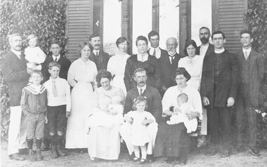 Ringwood and District Historical Society
Photograph, Group portrait - Miles Family and others - at 'Woorara' - Christmas 1914
Written below photograph, "At 'Woorara' - Christmas 1914. Back R-L Arnold Stawell, T.H.J., Ted Daniel, Wyn Pepperd, E.T.M., R.F.M., C.E.M., H.C.B., J.W.B., K.M.E.M., K.L.M. & Fred Daniel.Front R-L Mrs. Fred Daniel, A.T.M. and Joan, W.E.M. and Paddy". -
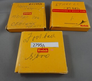 Greensborough Historical Society
Movie Film, Alan Partington home movies, 1960s
Alan Partington's hoe movies: Reel 1: Football Greensborough; Reel 2: Stawell Gift; Reel 3: Homecoming; Kids at Zoo; Geelong HeatsThree 8mm movie films in yellow card boxes.greensborough football club, stawell gift, geelong heats, alan partington -
Kew Historical Society Inc
Archive (Sub-series) - Subject File, Kew Historical Society, Houses [Kew], 1980
Various partiesReference, Research, InformationSecondary Values (KHS Imposed Order)Assorted printed materials, some published, such as: ‘What House is That? A guide to Victorian housing’ (Heritage Victoria, 2004), and guidelines for researching the history of a house (Fact Sheet, City of Boroondara). There is an article from the Progress Press about the demolition of Ellesmore, 80 Princess Street in 1977 (the article includes photographs of the demolition), Elizabeth Mackie’s notes on Myrtle Hill, and an article on the restoration of Mynda, Molesworth Street that was published in the Trust News (1987). Mrs Sewell of Stawell Street wrote handwritten notes/recollections about Cradley in Studley Park Road in 1981. In the photocopy about Ellesmore, there is also a separate article on the proposed replacement of the Walmer Street Bridge. There is also correspondence and an article on Stanhope on the corner of Burke and Cotham Roads. The file includes general real estate information and data.kew historical society - archives, kew - history, myrtle hill (kew), ellesmore - 80 princess street - kew (vic), mynda - molesworth street - kew (vic), stanhope - burke road - cotham road - kew (vic), cradley - studley park road - kew (vic), 17 queen street - kew (vic.)kew historical society - archives, kew - history, myrtle hill (kew), ellesmore - 80 princess street - kew (vic), mynda - molesworth street - kew (vic), stanhope - burke road - cotham road - kew (vic), cradley - studley park road - kew (vic), 17 queen street - kew (vic.) -
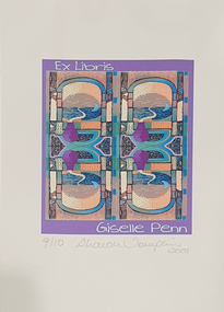 Federation University Art Collection
Work on paper - Bookplate, 'Ex Libris Giselle Penn'
After a quiet period, interest in bookplates in Australia began to increase in the early 1970s, Entrepreneurial art and book collectors such as Edwin Jewell and others commissioned multiple Bookplate designs from a range of well known fine artists. At a 1997 meeting in Melbourne of the Ephemera Society of Australia Edwin Jewell and others announced the formation of the Australian Bookplate Society. The society was instrumental in promoting the art of the bookplate through establishment of the Australian Bookplate Design competition. The competition includes a design award for secondary schools students.Bookplate depicts four repeated scenes of what appears to be a road leading to a hill9/10 Sharon Tompkin 2001bookplate, printmaking, australian bookplate design award, keith wingrove memorial trust, giselle penn -
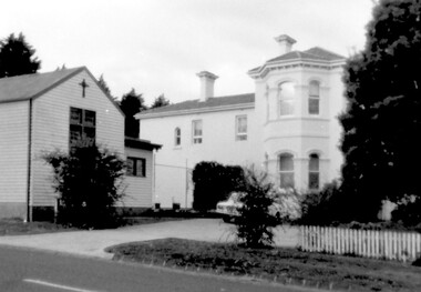 Surrey Hills Historical Society Collection
Photograph, Yielima, 31 Erasmus Street, Surrey Hills
Known as ‘Yielima’ 1888-1922 and ‘St. Aubins’ 1922-1956, this ‘modernized’ mansion was built about 1887 for Edward Kellett. He was born in Chorley, Lancashire, England. Edward Kellett married Selina Wells in 1852 at St Peters, Eastern Hill. She was born in c1827 in Aston Clinton, Buckinghamshire, daughter of William Wells and Elizabeth Allan. The family arrived from Aylesbury, Buckinghamshire on the 'Osprey' on 22 March 1849. The couple had 8 children - 5 girls and 3 boys; 3 died in infancy. All were born in Collingwood before the family came to Surrey Hills. Edward's funeral notice in The Argus of 11 July 1893 states that he was a corn merchant of Exhibition Street. His property was sworn at 1512 pounds, 1232 in realty and 280 pounds personally. He was buried in Melbourne General Cemetery (CofE Compartment K, No 306). Selina is listed in Erasmus Street in the 1903, 1905 and 1908 electoral rolls as a boarding house keeper. She died at Surrey Hills on 22/10/1911. In her will she left realty valued at 900 pounds and personally at 220 pounds. She was buried with her husband. 'Yielima' was sold on 19 Febraury 1919 with a sale of contents on 18 March 1919. From 1922-1947 Thomas Daniel O’Callaghan (c1871-1962), a police magistrate, made his home here. He is remembered as being of ‘soldierly demeanour, with a flowing mane of hair’. He always carried a walking stick and wore a flower in his buttonhole. His wife was Florence (nee Harling, c1873-1933) pre-deceased him. They had previously lived in Essendon, Moonee Ponds and Stawell before coming to Erasmus Street. After moving out of Erasmus Street he is listed in the 1949 and 1954 electoral rolls at 90 Durham Road, Surrey Hills. In 1952 the property was purchased by Father Timothy Fitzpatrick, Parish Priest of Our Holy Redeemer Parish, Surrey Hills. It consisted of a large two storey house, a coach house and stable, and an acre and a half of land. In 1954 the coach house and stable were converted into the Church of Our Lady of Perpetual Succour and the following year Father John Kelly was appointed parish priest. and resided in the house. At this time the house was not in good repair. "The gentleman who had lived there alone since his wife died many years before, lived in the servants quarters and the rest of the house had been badly neglected. (REF: https://ourholyredeemer.cam.org.au/history) At the beginning of 1957 the Missionary Sisters of the Sacred Heart opened a school next door. As they travelled from Balwyn on a daily basis, the property at 301 Elgar Road was purchased as a presbytery and 'Yielima' became a convent. The stables continued to be used as a church until 1964 when a new church was completed and opened by His Grace Archbishop Simmonds on the 20th of March. There were never large numbers of double-storey Victorian mansions in Surrey Hills. 'Yielma' is significant as one of the few remaining ones. It is also significant for its association with the Catholic Church.A black and white photograph of an Italianate style home with a weatherboard building with a cross on it in front of the main building and to the left of the photograph. There are some well established trees in the garden, a car parked in the parking area and a picket fence along the front.yielima, st aubins, house names, erasmus street, surrey hills, 1887, (mr) edward kellett, (mr) thomas daniel o'callaghan, corn merchant, police, italianate style, wattle park roman catholic church, (mrs) florence o'callaghan, mrs selina kellett, miss selina wells, convent, presbytery, our lady of perpetual succour -
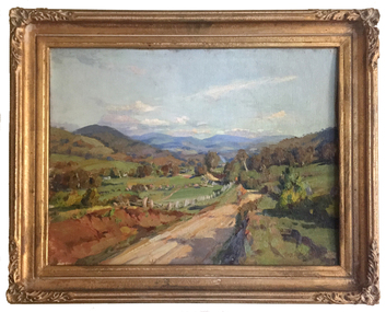 Federation University Art Collection
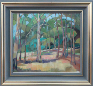
Painting, 'Road to Tallangatta' by Max Middleton, 1956
Max MIDDLETON (1922-2013) Born Melbourne In a career spanning 60 years, Max Middleton is known as a 'plein air' landscape painter the artist loved to paint sunrises, aiming to capture what he saw on the spot in paint. Capturing the light was crucial to his artworks. Max Middleton studied Drawing at the National Gallery School under William Rowell in 1938, and painting under Harold Septimus Power in 1940. The first of Middleton's 68 professional exhibitions took place in 1946. This item is part of the Federation University Art Collection. The Art Collection features over 1000 works and was listed as a 'Ballarat Treasure' in 2007.Framed oil painting of a landscape near Tallangatta.art, artwork, max middleton, landscape, tallangatta, available, middleton, oil on canvas -
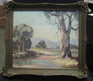 Federation University Art Collection
Oil on Board, Henri R. Nolte, 'The Road, Crookwell' by Henri R. Nolte
Hermann Hans Rudolf (Henry) NOLTE (1900-1965) Born Albury, New South Wales Died Sydney, New South Wales Born Hermann Hans Rudolf Nolte he called himself Harry and signed his paintings Henri because of anti-German sentiment during the world wars. This item is part of the Federation University Art Collection. The Art Collection features over 1000 works and was listed as a 'Ballarat Treasure' in 2007.Framed landscapeart, artwork, nolte, landscape, gumtree, hermann hans rudolf nolte, henry nolte, henri nolte, german artist -
 Federation University Art Collection
Painting - Watercolour, 'Towards Avoca' / 'Mount Buninyong in Autumn' by David Alexander, 1999
This item is part of the Federation University Art Collection. The Art Collection features over 1000 works and was listed as a 'Ballarat Treasure' in 2007.Unframed double sided landscape artwork by David Alexander. One side is 'Towards Avoca' and the other side is 'Buninyong From Main Road, 24/04/1999'David Alexander wrote on 'Buninyong From Main Road, 24/04/1999' "Wash wouldn't dry. People everywhere"art, artwork, david alexander, alexander, buninyong, avoca, watercolour -
 Federation University Art Collection
oil on masonite, David Alexander, Along Creswick Road, c1965
Creswick Road is in Ballarat.A painting of a landscape along Creswick Road, Ballarat by David Alexander. Gift of David Alexander, 2013Signed in ink lower left corner 'Along Creswick Road About 1965. D. Alexander'creswick road, ballarat, art, artist, david alexander -
Stawell Historical Society Inc
Book - Report, Conservstion Status of Roadsides in the Shire, 1991
Cover shire. Roadsides assessment: Species, Flora, Grazing, Cropping, Gravel, Noxious Weeds, Firebreaks, Road Design. With Loose maps x2 in Back Author Nicole StartPlastic front cover. Yellow Paper with Photo -
Stawell Historical Society Inc
Document - Report, Nicole Start, Conservation Status of Roadsides in the Shire of Stawell, 1991
Covers: Shire, roadsides, Assessment: Species, Flora, Grazing, Cropping, Gravel, Noxious weeds, Firebreaks, Road Design. With loos maps X 2 in back. Author Nicole StartPlastic Front Cover. Yellow Paper with Photo of a country road.Nicole Start Biological and Chemical Sciences Ballarat University Collage December 1991 -
Stawell Historical Society Inc
Joiner, Joiner from Diamond Drill, C. 1955
Dimond drills are put down to identify locations of gold bearing ore deposits, before mining drives are put in to extract the Ore. Sectionso fth eDimond Drill core are analyised for gold content. Drill joiner found near shaft no 26 in Ironbarks, near the intersection of Golf Course & southwest road. Conctrete shaft Cover still in PlaceMetal pipe threaded at both ends, used to join diamond Drill pipeing c 1955mining, gold -
Stawell Historical Society Inc
Realia, 2 Bricks from Pe-existing structure in Mt. William Creek
From 370 Long Gully Rd. Jallukar/ Pomonal, near Redmans RoadOne Large red fired brick shaped with a curve. One broken half brick with T Taylor stamped into FrogImpressed in Frog of Brick T Taylor -
Stawell Historical Society Inc
Map, Roads Maintained by NGSC. Roads Maintained by Other Authorities, C 2020
... Stawell Historical Society Inc 46 Longfield St Stawell ...Printed Colour map of Norther Grampians Shire, with roads marked in colourNorther Grampians Shire COuncil. 1:200,000shire, roads, transport -
 Stawell Historical Society Inc
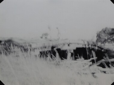
Photograph, Harris Bridge – Red Bend Road -- Great Western
... Bridge – Red Bend Road Great Western. stawell ...Harris Bridge – Red Bend Road Great Western.Black & white photo of Bridge. Photo is out of focus so hard to work out.Harris' Bridge Red bend Road Great Westernstawell -
 Stawell Historical Society Inc
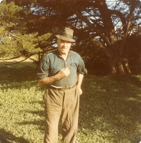
Photograph, Mr Ernie Tremaine -- Coloured photograph c 1980"s
The photo of Ernie Tremaine (died 16.4.1985) was taken by Alice Devereux. Alice and her sister Dot Sharrock stopped to look at the Treasury memorial on the Halls Gap road. Mr. Tremaine lived nearby and came out to chat with them.Coloured photo of Mr. Erne Tremaine dressed in casual clothes' and hat. c 1980'sstawell -
 Stawell Historical Society Inc
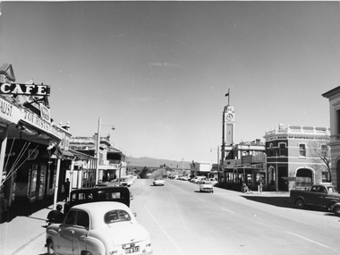
Photograph, Main Street Stawell looking West towards the Town Hall, on the right c 1960's
Main Street Stawell looking West including Town Hall Shops and Motor Vehicles c 1960's. This photo was taken by M. Robson before being donated to the society. The photo of Main St. was taken before it was made into a Mall, now know as "Gold Reef Mall". The street reopened to traffic in 2005.Black & white photograph of Main St Stawell looking towards the Grampians. The view includes the Town Hall & Bank of Australia on the right, with shops either side and two vehicles travelling along the road with vehicles parked along the street c 1960's.stawell business streetscape -
 Stawell Historical Society Inc
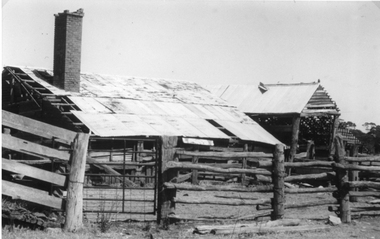
Photograph, Chaponnel Butchers Slaughter Yard cnr Clifton Avenue and Ormston Road -- 2 Photos & print of painting by Reg Cepon
Butchers Slaughter Yard cnr. Clifton Avenue and Ormston Road which belonged to Chaponnel family. These yards are now demolished. The land being sold for housing. 0099.2 is a photograph copy of an original oil painting titled "The Old Timer" by Reg Capon Nov. 1979. Painting owned by Mr. Phillip Nicholson Clifton Ave. Stawell.Two black and white photographs of a scene depicting a neglected timber building, with corrugated iron roof and brick chimney. Timber fence and race surround the stock yards. The painting (0099.2) is by Reg Capon called "The old Timer" Nov 1979.stawell business