Showing 4798 items matching "street map"
-
 Federation University Historical Collection
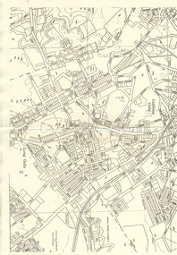
Map, Robinson's Ballarat Street Map, c1972, 1970s
... Robinson's Ballarat Street Map, c1972...A coloured fold-out street map of Ballarat. It also includes a district road map....Robinson's Ballarat Street Map, c1972 Map Map ...A coloured fold-out street map of Ballarat. It also includes a district road map.ballarat, map, ballarat streets -
 Kew Historical Society Inc
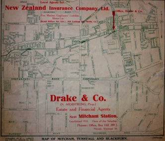
Map - Street Map, R L Jarrett, Map of Mitcham, Tunstall and Blackburn, 1929
... Street Map...This promotional street map is overprinted with the business address of the sponsors and advertising. ...Map of Mitcham, Tunstall and Blackburn Map Street Map R L Jarrett ...Tunstall was originally the name of Nunawading Railway Station. Tunstall opened on 4 June 1888 and was renamed on 1 November 1945. An historically significant advertising map that can be used to ascertain the extent of urban development in 1929 in the areas of Nunawading, Blackburn and Mitcham.A map of Mitcham, Tunstall and Blackburn found on the reverse of a real estate subdivision plan published by R. L. Jarrett of Elizabeth Street. This promotional street map is overprinted with the business address of the sponsors and advertising. Map overlaid in red print: "Drake & Co. / (N. Armstrong, Prop.) / Estate and Financial Agents / next Mitcham Station / Established 1914. Open all day Saturday. / Phones: Office, Box Hill 289 J. / Private, Vermont 10."real estate agents, mitcham, tunstall, blackburn, road maps, drake & co, new zealand insurance co ltd -
 Mission to Seafarers Victoria
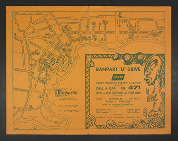
Map - Street Map, Port de Papeete Tahiti
... Street Map...Tourist map of the streets of Port de Papeete, Tahiti printed in greenish-grey ink on thin ochre coloured cardboard. ...Port de Papeete Tahiti Map Street Map ...Several items were given by a seafarer, Mr Nicholas Garlick (1926-2009) into the care of Father Brady who retired from St Pauls Cathedral, Melbourne in 2018. Father Brady later donated the collection of; objects, documents and an extensive collection of cruise ship menus (1937-end of 20thC) to the Mission via the intermediary William Hastie, volunteer at the Mission for Seafarers.Tourist map of the streets of Port de Papeete, Tahiti printed in greenish-grey ink on thin ochre coloured cardboard. Produced for Hertz rent a car (see media). port de papeete, tahiti, hertz, nick garlick, nicholas garlick, father brady, william hastie, ship engineer, sailors, seamen, seafarers -
 Ballarat Tramway Museum
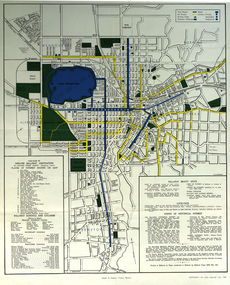
Map - Street map with bus routes, State Electricity Commission of Victoria - Electricity Supply Department, Ballarat, 1960's
... Street map with bus routes...Beige paper copy of original dyeline print. Ballarat. Map Street map with bus routes State Electricity Commission of Victoria - Electricity Supply Department ...Produced by the SEC to document the Ballarat Bus Routes.Print of a drawing showing in very good detail, a map of Ballarat with the bus routes coloured in with pencil.SEC map of Ballarat with hand coloured bus routes. Drawn 1960's. Beige paper copy of original dyeline print. Copy of original. Ballarat bus routes coloured in with pencil.provincial tramways, state electricity commission of victoria, map, ballarat, bus routes -
 Greensborough Historical Society
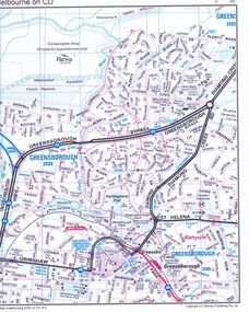
Map, Melway Publishing Pty Ltd, Greensborough: Melbourne on CD, 2006
... Copy of part of Greensborough street map printed froma 2006 version of Melbourne on CD V.4....Coloured street map of Greensborough...Copy of part of Greensborough street map printed froma 2006 version of Melbourne on CD V.4. ...Copy of part of Greensborough street map printed froma 2006 version of Melbourne on CD V.4.Coloured street map of Greensboroughgreensborough, melway -
Whitehorse Historical Society Inc.
Map, City of Nunawading Street and Block Map
... City of Nunawading Street and Block Map...City of Nunawading Street and Block map. Scale: 1:10,000. with enlargement, Canterbury Road South to Burwood Highway....Canterbury Road Nunawading Burwood Highway Burwood East City of Nunawading City of Nunawading Street and Block map. City of Nunawading Street and Block map. ...City of Nunawading Street and Block map.City of Nunawading Street and Block map. Scale: 1:10,000. with enlargement, Canterbury Road South to Burwood Highway.City of Nunawading Street and Block map. canterbury road nunawading, burwood highway burwood east, city of nunawading -
 Bendigo Historical Society Inc.
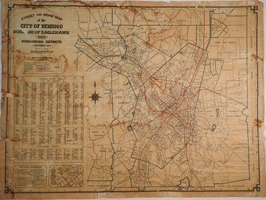
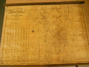
Map - CITY OF BENDIGO STREET AND ROAD MAP, 1946
... CITY OF BENDIGO STREET AND ROAD MAP...Map: City of Bendigo Street and road map, Incorporating the Borough of Eaglehawk and surrounding Districts. ...History House 11 Mackenzie Street Bendigo goldfields MAP Bendigo city streets Bendigo Streets Map: City of Bendigo Street and road map, Incorporating the Borough of Eaglehawk and surrounding Districts. ...Map: City of Bendigo Street and road map, Incorporating the Borough of Eaglehawk and surrounding Districts. Compiled by W.C Harry 1946, Examined by J. Harry 1946.map, bendigo, city streets, bendigo streets -
 Melbourne Tram Museum
Map, Morgan Street directory - map of VR Trams, Map - 1940s?
... Morgan Street directory - map of VR Trams...Map - assembled from sheets of the Morgan Street directory for the two VR street tramways from St Kilda to Brighton and from Sandringham Station to Beaumaris or Black Rock. ...Has many adverts on the rear and front for funeral parlours, hotels, real estate agents and the like. Morgan Street directory - map of VR Trams Map ...Map - assembled from sheets of the Morgan Street directory for the two VR street tramways from St Kilda to Brighton and from Sandringham Station to Beaumaris or Black Rock. Comprises four sheets taped together and one loose sheet. Tram route marked in green felt pen. Has many adverts on the rear and front for funeral parlours, hotels, real estate agents and the like.trams, tramways, map, vr, sandringham, black rock, beaumaris, brighton, st kilda -
 Bendigo Historical Society Inc.
Map - STREET AND ROAD MAP OF THE CITY OF BENDIGO BOROUGH OF EAGLEHAWK AND SURROUNDING DISTRICTS
... STREET AND ROAD MAP OF THE CITY OF BENDIGO BOROUGH OF EAGLEHAWK AND SURROUNDING DISTRICTS...Silver duct tape attached to top to secure map. Map shows streets of Bendigo and Eaglehawk. Written on map "Compiled by W.C. ...Examined by J. Harry 1946." Map STREET AND ROAD MAP OF THE CITY OF BENDIGO BOROUGH OF EAGLEHAWK AND SURROUNDING DISTRICTS ...Heavy paper map with fabric backing. Timber piece attached at top, dowel attached to bottom. String in centre for hanging. Silver duct tape attached to top to secure map. Map shows streets of Bendigo and Eaglehawk. Written on map "Compiled by W.C. Harry 1946. Examined by J. Harry 1946."map, bendigo, bendigo and borough of eaglehawk -
 Whitehorse Historical Society Inc.
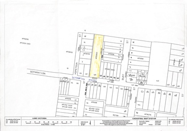
Map, 125 Separation Street, Northcote. Cadastral Map, 21/11/2001
... 125 Separation Street, Northcote. Cadastral Map...A3 Cadastral Map of 125 Separation Street, Northcote August Schwerkolt purchased this property on 01/08/1853 where he lived and farmed the land, eventually purchasing the Mitcham property as well in 1861...Whitehorse Historical Society Inc. 2-10 Deep Creek Road Mitcham melbourne A3 Cadastral Map of 125 Separation Street, Northcote August Schwerkolt purchased this property on 01/08/1853 where he lived and farmed the land, eventually purchasing the Mitcham property as well in 1861 Schwerkolt August An A3 cadastral map 125 Separation Street, Northcote. ...A3 Cadastral Map of 125 Separation Street, Northcote August Schwerkolt purchased this property on 01/08/1853 where he lived and farmed the land, eventually purchasing the Mitcham property as well in 1861An A3 cadastral mapschwerkolt august -
University of Melbourne, Burnley Campus Archives
Plan, VCAH Burnley College Swan Street Richmond - Classroom Locations Map, c.1991
... VCAH Burnley College Swan Street Richmond - Classroom Locations Map...VCAH Burnley College Swan Street Richmond - Classroom Locations Map Plan ...2 copies of plan dated c1991. Buildings named, classrooms numbered.vcah, burnley, classrooms -
 Bendigo Historical Society Inc.
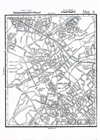
Map - LONG GULLY HISTORY GROUP COLLECTION: MAP OF LONG GULLY AREA
... ...Street map Long Gully/California Gully....map of Long Gjully and California Gully area from Craig Street to Barrell Street. ...History House 11 Mackenzie Street Bendigo goldfields EAGLEHAWK History Street map Long Gully/California Gully. map of Long Gjully and California Gully area from Craig Street to Barrell Street. ...map of Long Gjully and California Gully area from Craig Street to Barrell Street. Indicators show location of the mental hygiene Austhority, Agricultural Showgrounds and Recreation Reserve. The boundary between the Borough of Eaglehawk and Bendigo is shown by a dotted line along McGowan Street.eaglehawk, history, street map long gully/california gully. -
 Bayside Gallery - Bayside City Council Art & Heritage Collection
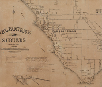
Map, Department of Crown Lands and Survey, Melbourne and Suburbs, City of Sandringham, 1917-1926
... ...street map...Bayside Gallery - Bayside City Council Art & Heritage Collection Corner Wilson and Carpenter Streets Brighton melbourne map plan foreshores sndringham hampton beaumaris cheltenham department of lands and survey cartographic material borough of sandringham moorabbin black rock street map City of Sandringham Photolithograph. ...map, plan, foreshores, sndringham, hampton, beaumaris, cheltenham, department of lands and survey, cartographic material, borough of sandringham, moorabbin, black rock, street map, city of sandringham -
 Bayside Gallery - Bayside City Council Art & Heritage Collection
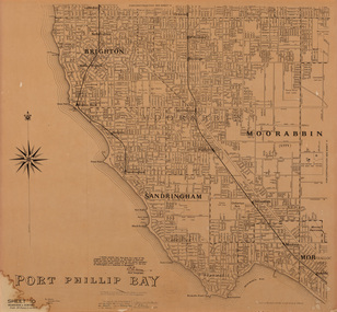
Map, Department of Lands and Survey, Land under the control of the City of Sandringham, 1962
... ...street map...Bayside Gallery - Bayside City Council Art & Heritage Collection Corner Wilson and Carpenter Streets Brighton melbourne The cadastral map showing land under the control of the City of Brighton in 1962. map plan foreshores sndringham hampton beaumaris cheltenham department of lands and survey cartographic material moorabbin black rock street map City of Sandringham Board of Lands and Works Print. ...The cadastral map showing land under the control of the City of Brighton in 1962.map, plan, foreshores, sndringham, hampton, beaumaris, cheltenham, department of lands and survey, cartographic material, moorabbin, black rock, street map, city of sandringham, board of lands and works -
 Greensborough Historical Society
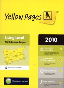
Book - Directory, Telstra Corporation Limited, Yellow Pages: Living local North Eastern Region 2010, 2010
... 432 p black print on white and yellow paper, paperback, includes UBD Street maps and street index...Greensborough Historical Society 34A Glenauburn Road Lower Plenty Lower Plenty melbourne Yellow Pages is a listing of businesses and organisations and their telephone numbers and addresses within the north eastern region of Melbourne telephone directories north east melbourne 432 p black print on white and yellow paper, paperback, includes UBD Street maps and street index Yellow Pages: Living local North Eastern Region 2010 Book Directory Telstra Corporation Limited ...Yellow Pages is a listing of businesses and organisations and their telephone numbers and addresses within the north eastern region of Melbourne432 p black print on white and yellow paper, paperback, includes UBD Street maps and street indextelephone directories, north east melbourne -
 Ballarat Tramway Museum
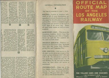
Map, H.P. Noordwal, "Official Route Map of the Los Angeles Railway", Jun. 1938
... ... Street Cars... Map...A (12 section) fold out map of street car (tram) and bus services for Los Angeles, dated June 1, 1938, showing all LAR (Los Angeles Railway) streetcar and coach (tram and bus) services, Pacific Electric lines within area, detailed "downtown" map, route descriptions and points of interest. ...Ballarat Tramway Museum South Gardens Reserve Wendouree Parade Ballarat Ballarat goldfields Trams tramways Los Angeles Street Cars Map Three terminus have been marked with pencil "X". ...A (12 section) fold out map of street car (tram) and bus services for Los Angeles, dated June 1, 1938, showing all LAR (Los Angeles Railway) streetcar and coach (tram and bus) services, Pacific Electric lines within area, detailed "downtown" map, route descriptions and points of interest. Record images added 20/8/2013.Three terminus have been marked with pencil "X". On rear car, next to object number is a symbol looking like a "H & S" merged together.trams, tramways, los angeles, street cars, map -
 Federation University Historical Collection
Map, Greater Ballarat, 1968, 07/1968
... Coloured street map of Greater Ballarat, including Sebastopol, and portions of the Shires of Ballarat, Buninyong, and Grenville....Barker Library (top floor) Mount Helen goldfields ballarat map greater ballarat association Sebstopol Canadian Eureka Alfredton Wendouree Ballarat East Mount Pleasant Zilles Print Coloured street map of Greater Ballarat, including Sebastopol, and portions of the Shires of Ballarat, Buninyong, and Grenville. ...Coloured street map of Greater Ballarat, including Sebastopol, and portions of the Shires of Ballarat, Buninyong, and Grenville.ballarat, map, greater ballarat association, sebstopol, canadian, eureka, alfredton, wendouree, ballarat east, mount pleasant, zilles print -
 Bendigo Historical Society Inc.
Map - LONG GULLY HISTORY GROUP COLLECTION: MAP OF LONG GULLY
... Copy of a street map showing Jobs Gully, California Gully, Long Gully, St Just's Point and Iron Bark....History House 11 Mackenzie Street Bendigo goldfields BENDIGO History long gully history group The Long Gully History Group - Map of Long Gully Jobs Gully California Gully Long Gully St Just's Point Iron Bark Copy of a street map showing Jobs Gully, California Gully, Long Gully, St Just's Point and Iron Bark. ...Copy of a street map showing Jobs Gully, California Gully, Long Gully, St Just's Point and Iron Bark.bendigo, history, long gully history group, the long gully history group - map of long gully, jobs gully, california gully, long gully, st just's point, iron bark -
 Ringwood and District Historical Society
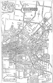
Document, Reference Map of Ringwood, Victoria - Circa 1962-63
... A3 size photocopied street map with alpha-numeric labeled divisions identifying "Collector's Districts" (of un-named organisation). ...A3 size photocopied street map with alpha-numeric labeled divisions identifying "Collector's Districts" (of un-named organisation). ...A3 size photocopied street map with alpha-numeric labeled divisions identifying "Collector's Districts" (of un-named organisation). Legend: Railway Lines, Bus Routes, Reserved Open Areas, Town Hall & P.O., Police Station, Area Being Sewered 62-63, Primary Secondary and Technical Schools, and Collector's Districts, e.g. A1, A2, B1, B2, etc. -
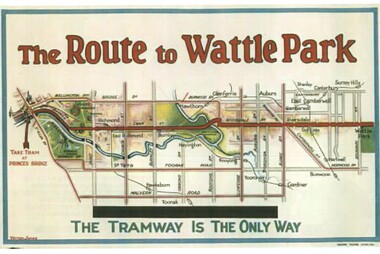 Melbourne Tram Museum
Drawing - Illustration, Tramway Museum Society of Victoria (TMSV), "The Route to Wattle Park", 16/03/2006 12:00:00 AM
... Illustration from a TMSV Calendar, "The Route to Wattle Park" showing the route overlain in red on a street map. From an original MMTB Poster....Melbourne Tram Museum 8 Wallen Road Hawthorn melbourne Trams tramways MMTB Posters Illustrations Wattle Park Illustration from a TMSV Calendar, "The Route to Wattle Park" showing the route overlain in red on a street map. From an original MMTB Poster. ...Illustration from a TMSV Calendar, "The Route to Wattle Park" showing the route overlain in red on a street map. From an original MMTB Poster.trams, tramways, mmtb, posters, illustrations, wattle park -
 Ringwood and District Historical Society
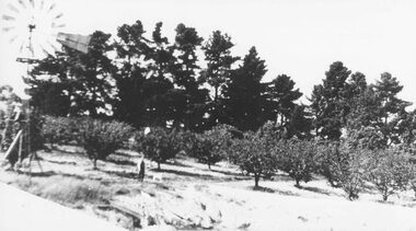
Photograph, H.E. Watson's orchard- Ringwood East. c1900's
... Included with image is a copy of early street map showing location of orchard on corner of Old Lillydale Road and Maroondah Highway....Included with image is a copy of early street map showing location of orchard on corner of Old Lillydale Road and Maroondah Highway. ...Black and white photographWritten on backing sheet- "H. E. Watson's Orchard. Ringwood East." Included with image is a copy of early street map showing location of orchard on corner of Old Lillydale Road and Maroondah Highway.agriculture -
 Eltham District Historical Society Inc
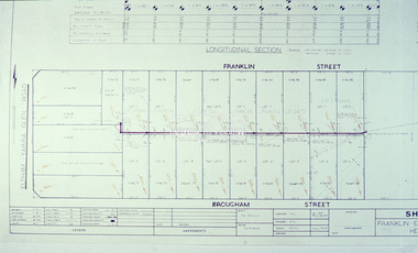
Slide - Photograph, Eltham Shire Council, EB 8 (b) Health Act Scheme, Franklin and Brougham streets, Eltham, 1969
... street...Infrastructure...Map...Eltham District Historical Society Inc 728 Main Rd Eltham melbourne Brougham Steet Eltham franklin street Infrastructure Map planning Subdivison Lots Health Act Scheme EB 8 (b) Health Act Scheme, 4 August 1969 35mm colour positive transparency blue Agfacolour Service plastic mount EB 8 (b) Health Act Scheme, Franklin and Brougham streets, Eltham Slide Photograph Eltham Shire Council ...35mm colour positive transparency blue Agfacolour Service plastic mountEB 8 (b) Health Act Scheme, 4 August 1969brougham steet, eltham, franklin street, infrastructure, map, planning, subdivison lots, health act scheme -
 Bendigo Historical Society Inc.
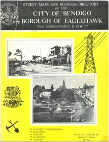
Document - STREET MAPS AND BUSINESS DIRECTORY - BENDIGO & DISTRICTS, 1970
... Street Maps and Business Business Directory 1975 City of Bendigo Borough of Eaglehawk and Surrounding District Black and Yellow Cover. ...Eighty eight pages. 1973 Document STREET MAPS AND BUSINESS DIRECTORY - BENDIGO & DISTRICTS ...BHS CollectionStreet Maps and Business Business Directory 1975 City of Bendigo Borough of Eaglehawk and Surrounding District Black and Yellow Cover. Eighty eight pages. 1973Drawn and Compiled by Wesley C Harry -
 Greensborough Historical Society
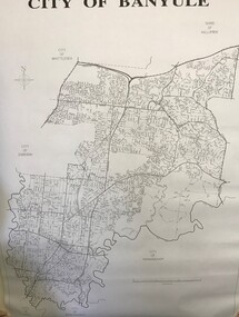
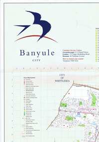
Maps, Banyule City Council, City of Banyule, 1970c
... Street map of City of Banyule. No physical features....Greensborough Historical Society 34A Glenauburn Road Lower Plenty Lower Plenty melbourne Street map of City of Banyule. No physical features. banyule city council Black and white map of City of Banyule. ...Street map of City of Banyule. No physical features.Black and white map of City of Banyule. Scale: 8 cm:1 km. banyule city council -
 Eltham District Historical Society Inc
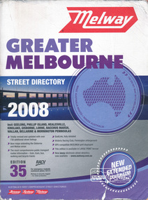
Book, Melway Greater Melbourne street directory 2008 : including Geelong, Phillip Island, Healesville, Kinglake, Gisborne, Lorne, Bacchus March, Wallan, Bellarine & Mornington Peninsulas; Edition 35, 2008, 2007
... Edition 35. 2008 Coloured detailed maps accessed by a street or location index. Cover: Totally revised and updated with over 730 additional street listings, new maps extending the Gisbourne and Wallan areas. ...Street directory, coloured maps, indexes, 1201 pages...Eltham District Historical Society Inc 728 Main Rd Eltham melbourne Edition 35. 2008 Coloured detailed maps accessed by a street or location index. Cover: Totally revised and updated with over 730 additional street listings, new maps extending the Gisbourne and Wallan areas. ...Edition 35. 2008 Coloured detailed maps accessed by a street or location index. Cover: Totally revised and updated with over 730 additional street listings, new maps extending the Gisbourne and Wallan areas. The most comprehensive public transport routes information - train, tram, bus, walking and bicycle tracks. Eastlink fully detailed, Victoria Racing Club, Flemington enlargement, GPS compatible WGS/MGA Grid displayed, This editon is available in LARGE PRINT format, new eway electronic street directory now available - www.melway.com.au Special feature: New Hierachy of Roads Street directory, coloured maps, indexes, 1201 pagesstreets,roads,melbourne,map,melway -
 Bendigo Historical Society Inc.
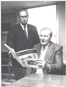
Photograph - WES HARRY COLLECTION: PROFESSOR MANNING-CLARK, 1973
... They are studying a copy of the ' City of Bendigo and Borough of Eaglehawk, Street maps and Business Directory....They are studying a copy of the ' City of Bendigo and Borough of Eaglehawk, Street maps and Business Directory. Photograph WES HARRY COLLECTION: PROFESSOR MANNING-CLARK ...Black and white photograph of Professor Manning - Clark (standing) and an unknown Gentleman (seated). They are studying a copy of the ' City of Bendigo and Borough of Eaglehawk, Street maps and Business Directory.Bendigo Advertiserperson, group, business, professor manning clark -
Glenelg Shire Council Cultural Collection
Booklet - Booklet - Historic Portland Street Names Victoria, c. 1972
... Yellow pages, black print, street map affixed to inside back cover...Yellow pages, black print, street map affixed to inside back cover Booklet Booklet - Historic Portland Street Names Victoria E.N.T HENRY E. ...Sixteen page booklet, grey card cover, red and blue print, Historic Portland street Names, their location, origin and significance. Yellow pages, black print, street map affixed to inside back cover -
 Bendigo Historical Society Inc.
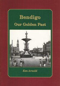
Book - BENDIGO OUR GOLDEN PAST, 2007
... Photographs: black and white. Street maps, copy opf painting. 80 pages. Signed by: Ken Arnold, December 2007. 80 pages....Photographs: black and white. Street maps, copy opf painting. 80 pages. Signed by: Ken Arnold, December 2007. 80 pages. ...Bendigo Our Golden Past. Signed by Ken Arnold 2007. History of Bendigo. Photographs: black and white. Street maps, copy opf painting. 80 pages. Signed by: Ken Arnold, December 2007. 80 pages.Ken Arnoldbendigo, history, bendigo & district, history of bendigo -
 Greensborough Historical Society
Map, Banyule City, September 1996
... Colour map, street index on verso....Greensborough Historical Society 34A Glenauburn Road Lower Plenty Lower Plenty melbourne City of Banyule map, including clubs, leisure, cultural & heritage facilities and other features. city of banyule maps Colour map, street index on verso. Banyule City Map Map Banyule City Council ...City of Banyule map, including clubs, leisure, cultural & heritage facilities and other features.Colour map, street index on verso.city of banyule, maps -
 Numurkah & District Historical Society
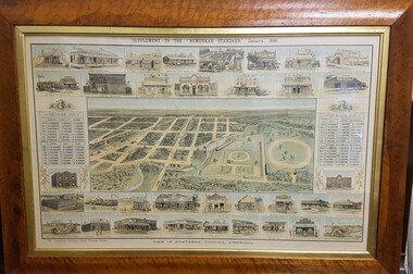
Map - Print in frame - Numurkah Township 1888, Supplement to the "Numurkah Standard" January 1888 View of Numurkah Victoria Australia
... Artist's view/impression of Numurkah streets (map) surrounded by artwork of a number of Numurkah businesses in the town and local district. ...Artist's view/impression of Numurkah streets (map) surrounded by artwork of a number of Numurkah businesses in the town and local district. ...The late Hilda Morieson (very active in early Historical Society) owned the print. It was then passed on to Mary Morieson, then to Rosemary Kennet. It has been passed onto the Historical Society with permission from Ben Morieson, Hilda's grandsonLarge coloured print of supplement to Numurkah Standard 1888. Artist's view/impression of Numurkah streets (map) surrounded by artwork of a number of Numurkah businesses in the town and local district. The print is under glass in a faux-wood-grained framesee photo abovenumurkah standard, numurkah township map, numurkah businesses, 1888, print