Showing 1088 items matching streetscapes
-
 Hume City Civic Collection
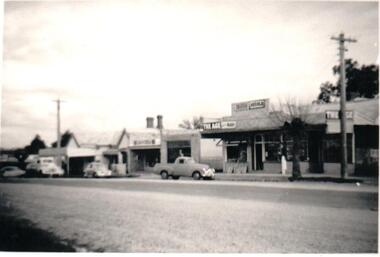
Photograph, 1952
B/W photograph of a streetscape in Brook Street, Sunbury. It shows Mr Ron Geyer's Newspaper shop.Handwritten on back: MR RON GEYERS' NEWSPAPER SHOP, IN BROOK STREET, 1952newspapers, shops, businesses, geyer's newspaper shop, brook street, sunbury, streetscape, geyer, ron, 1950s, george evans collection -
 Whitehorse Historical Society Inc.
Newspaper - Article, Residents fear for streetscape, 28/09/1994
'Residents fear for streetscape' ' Mitcham Mansion,' (Walker home), Meerut Street, Mitcham, land subdivision opposite.meerut street, mitcham, walker, edgar edwardes, australian tesselated tile co pty ltd, barelli, ken, land subdivision -
Clunes Museum
ARTWORK, Anderson, Ian L, Clunes Streetscape, 1999
Framed pen and pastel drawing of the Town Hall, Clunes. Framed painted gold, cream coloured mat boardOn reverse: Clunes Streetscape, Pen & Pastel by Ian L Anderson, (address & telephone number (private), signed Ian L Anderson Nov 99clunes town hall, pen & pastel -
 Robin Boyd Foundation
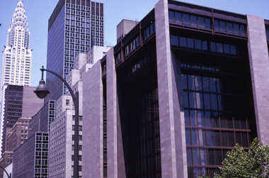
Slide, Robin Boyd, 1969
Robin Boyd travelled to the USA and Britain for several weeks. He attended the opening of the new Australian Chancery in Washington DC, where he had designed an innovative exhibition with cylindrical display cases and sound recordings.Colour slide in a mount. NYC streetscape showing Ford Foundation (S0990) foreground and Chrysler Building (S0522) backgroundMade in Australia / 8 / JUL 69M2slide, robin boyd -
Canterbury History Group
Photograph - Streetscape of the corner of Bryson Street and Maling Road, Pigot, Jan, 1994
Coloured photograph of the streetscape of the corner of Bryson Street and Maling Road. This is also the corner of the building named The Block 1907.canterbury, maling road, shops, bryson street, the block, buckley family -
 Kiewa Valley Historical Society
Photographs – Kiewa Cres Mt Beauty. Circa 1993. Set of 12 colour photographs
Established in 1946, during the construction of the Kiewa Hydro Electric Scheme, the township of Mt Beauty was developed by the State Electricity Commission of Victoria to provide additional accommodation for the thousands of workers during the construction of the country’s second largest hydro-electricity scheme. Although these towns were built as temporary accommodation for the workers and their families, many stayed after the scheme finished. Combined with the influx of European migrants, with their rich cultural backgrounds, all played a major part in shaping the future character of the Mount Beauty, the Kiewa Valley and Falls Creek. The Bright Council, now the Alpine Shire took over the control of the township in 1960. This relatively young town of Mount Beauty, along with the surrounding townships of Falls Creek, Bogong, Tawonga South and Tawonga, are all part of a prospering tourist area with excellent services, accommodation, food and a wide range of recreational activities available for all ages. According to Shire records, the population of Mt Beauty has grown from 1,500 in 1981 to 1,800 in 2016 with a projected increase to 2,000 in 2013The photographs taken around 1993 show a prosperous commercial centre catering for both locals and the needs of visitors. It provides a pictorial history of the changes which have occurred in the retail/commercial district of Mt Beauty over the years. It also demonstrates the attention paid by Alpine Shire towards providing accessible recreational green space around the town centre.Set of 12 colour photographs of Kiewa Cres Mt Beauty. Circa 1993 showing retail services and streetscape of the time. No markingskiewa cres mt beauty, mt beauty -
 Kiewa Valley Historical Society
Photographs – Lakeside Avenue, Mt Beauty. Circa 1993. Set of 7 colour photographs
Established in 1946, during the construction of the Kiewa Hydro Electric Scheme, the township of Mt Beauty was developed by the State Electricity Commission of Victoria to provide additional accommodation for the thousands of workers during the construction of the country’s second largest hydro-electricity scheme. Although these towns were built as temporary accommodation for the workers and their families, many stayed after the scheme finished. Combined with the influx of European migrants, with their rich cultural backgrounds, all played a major part in shaping the future character of the Mount Beauty, the Kiewa Valley and Falls Creek. The Bright Council, now the Alpine Shire took over the control of the township in 1960. This relatively young town of Mount Beauty, along with the surrounding townships of Falls Creek, Bogong, Tawonga South and Tawonga, are all part of a prospering tourist area with excellent services, accommodation, food and a wide range of recreational activities available for all ages. According to Shire records, the population of Mt Beauty has grown from 1,500 in 1981 to 1,800 in 2016 with a projected increase to 2,000 in 2013The photographs taken around 1993 show a prosperous commercial centre catering for both locals and the needs of visitors. It provides a pictorial history of the changes which have occurred in the retail/commercial district of Mt Beauty over the years. It also demonstrates the attention paid by Alpine Shire towards providing accessible recreational green space around the town centre.Set of 7 colour photographs of Lakeside Avenue, Mt Beauty. Circa 1993 showing retail services and streetscape of the time. No markingsmt beauty, lakeside ave mt beauty -
 Kiewa Valley Historical Society
Photographs – Tawonga Cres., Mt Beauty. Circa 1993. Set of 4 colour photographs
Established in 1946, during the construction of the Kiewa Hydro Electric Scheme, the township of Mt Beauty was developed by the State Electricity Commission of Victoria to provide additional accommodation for the thousands of workers during the construction of the country’s second largest hydro-electricity scheme. Although these towns were built as temporary accommodation for the workers and their families, many stayed after the scheme finished. Combined with the influx of European migrants, with their rich cultural backgrounds, all played a major part in shaping the future character of the Mount Beauty, the Kiewa Valley and Falls Creek. The Bright Council, now the Alpine Shire took over the control of the township in 1960. This relatively young town of Mount Beauty, along with the surrounding townships of Falls Creek, Bogong, Tawonga South and Tawonga, are all part of a prospering tourist area with excellent services, accommodation, food and a wide range of recreational activities available for all ages. According to Shire records, the population of Mt Beauty has grown from 1,500 in 1981 to 1,800 in 2016 with a projected increase to 2,000 in 2013The photographs taken around 1993 show a prosperous commercial centre catering for both locals and the needs of visitors. It provides a pictorial history of the changes which have occurred in the retail/commercial district of Mt Beauty over the years. It also demonstrates the attention paid by Alpine Shire towards providing accessible recreational green space around the town centre.Set of 4 colour photographs Tawonga Crescent, Mt Beauty. Circa 1993 showing retail services and streetscape of the time No markingstawonga cres mt beauty -
 Kiewa Valley Historical Society
Photographs – Kiewa Cres Mt Beauty. Circa 1993. Set of 12 colour photographs, circa 1993
Established in 1946, during the construction of the Kiewa Hydro Electric Scheme, the township of Mt Beauty was developed by the State Electricity Commission of Victoria to provide additional accommodation for the thousands of workers during the construction of the country’s second largest hydro-electricity scheme. Although these towns were built as temporary accommodation for the workers and their families, many stayed after the scheme finished. Combined with the influx of European migrants, with their rich cultural backgrounds, all played a major part in shaping the future character of the Mount Beauty, the Kiewa Valley and Falls Creek. The Bright Council, now the Alpine Shire took over the control of the township in 1960. This relatively young town of Mount Beauty, along with the surrounding townships of Falls Creek, Bogong, Tawonga South and Tawonga, are all part of a prospering tourist area with excellent services, accommodation, food and a wide range of recreational activities available for all ages. According to Shire records, the population of Mt Beauty has grown from 1,500 in 1981 to 1,800 in 2016 with a projected increase to 2,000 in 2013The photographs taken around 1993 show a prosperous commercial centre catering for both locals and the needs of visitors. It provides a pictorial history of the changes which have occurred in the retail/commercial district of Mt Beauty over the years. It also demonstrates the attention paid by Alpine Shire towards providing accessible recreational green space around the town centre.Set of 12 colour photographs Kiewa Cres Mt Beauty. Circa 1993 showing retail services and streetscape of the time. No markingskiewa crescent mt beauty; shopping centre; -
![Painting, S.H. Raza, [Streetscape], 1977](https://victoriancollections.net.au/media/collectors/57a00a4fd0cdd1210422a51e/items/63e726a58b6b08140b576b30/item-media/63e728678b6b08140b57b643/item-fit-380x285.jpg) Ballarat Heritage Services
Ballarat Heritage ServicesPainting, S.H. Raza, [Streetscape], 1977
Framed streetscape with people in a shopping precinct. If you can provide information on this artist or artwork please use the link below. LRS G.H. Raza 77."painting, townscape, streetscape -
Clunes Museum
PAINTINGS, David Williams
Images of; Horse Trough & Wagon Residence 94 Bailey Street Former Presbytery St. Thomas Aquinas Former Clunes Free Library Residence 25 Camp Street Monument 100 years of gold Clunes in Melb Monument Former butcher's shop Fraser Street Residence & shops 41-43 Fraser Street Clunes School of Mines Clunes War Memorial Residence 32 Leslie St Clunes Former suspension bridge Former St Paul's Vicarage 42 Service Street Former Police Office Former Police residence Portable Lock Up Former Dow Residence 9 Hill St Former Hall & Fire Station 2 Hill St St Paul's timber Church hall St Paul's Church Masonic Lodge 23 Service St St Paul's Pulpit Masonic Lodge interior Everhard cordial bottles Scythes in Clunes Museum Ascot Blacksmith shop Former Ascot hotel MIA Hall Ascot The Coghill Monument Former Methodist Church Coghills Creek Clunes Cemetery Chapel Maiden Hill Homestead shearing shed Beckworth Court stables Beckworth Cour shearer's quarters Former School Evansford Glengower Outbuilding Amerst Former Mortuary 46-50 Fraser Street Wood fired heater Beckworth court farm shed Gold mine trolley Servant's bells Maiden Hill cow bail Former South Clunes school 29 George Street 70 Fraser Street Former Post Office "Allowah" Clunes Street Ascot "Homestead" Beackwith Court "The Meat House" Beckwith Court "Shearing Sheds" Beckwith Court Evansford Community Hall 54 watercolours remaining from the 2003 exhibition held at Clunes, all unframed, depicting Clunes and surrounds architecture and streetscapes.watercolour, 2003 exhibition -
 Kiewa Valley Historical Society
Photographs – Holland Street North, Mt Beauty. Circa 1993. Set of 18 colour photographs
Established in 1946, during the construction of the Kiewa Hydro Electric Scheme, the township of Mt Beauty was developed by the State Electricity Commission of Victoria to provide additional accommodation for the thousands of workers during the construction of the country’s second largest hydro-electricity scheme. Although these towns were built as temporary accommodation for the workers and their families, many stayed after the scheme finished. Combined with the influx of European migrants, with their rich cultural backgrounds, all played a major part in shaping the future character of the Mount Beauty, the Kiewa Valley and Falls Creek. The Bright Council, now the Alpine Shire took over the control of the township in 1960. This relatively young town of Mount Beauty, along with the surrounding townships of Falls Creek, Bogong, Tawonga South and Tawonga, are all part of a prospering tourist area with excellent services, accommodation, food and a wide range of recreational activities available for all ages. According to Shire records, the population of Mt Beauty has grown from 1,500 in 1981 to 1,800 in 2016 with a projected increase to 2,000 in 2013The photographs taken around 1993 show a prosperous commercial centre catering for both locals and the needs of visitors. It provides a pictorial history of the changes which have occurred in the retail/commercial district of Mt Beauty over the years. It also demonstrates the attention paid by Alpine Shire towards providing accessible recreational green space around the town centre.Set of 18 colour photographs Holland Street North, Mt Beauty. Circa 1993 showing retail services and streetscape of the time. No markingsholland st mt beauty, mt beauty -
 Kiewa Valley Historical Society
Photographs – Holland Street South, Mt Beauty. Circa 1993. Set of 16 colour photographs
Established in 1946, during the construction of the Kiewa Hydro Electric Scheme, the township of Mt Beauty was developed by the State Electricity Commission of Victoria to provide additional accommodation for the thousands of workers during the construction of the country’s second largest hydro-electricity scheme. Although these towns were built as temporary accommodation for the workers and their families, many stayed after the scheme finished. Combined with the influx of European migrants, with their rich cultural backgrounds, all played a major part in shaping the future character of the Mount Beauty, the Kiewa Valley and Falls Creek. The Bright Council, now the Alpine Shire took over the control of the township in 1960. This relatively young town of Mount Beauty, along with the surrounding townships of Falls Creek, Bogong, Tawonga South and Tawonga, are all part of a prospering tourist area with excellent services, accommodation, food and a wide range of recreational activities available for all ages. According to Shire records, the population of Mt Beauty has grown from 1,500 in 1981 to 1,800 in 2016 with a projected increase to 2,000 in 2013The photographs taken around 1993 show a prosperous commercial centre catering for both locals and the needs of visitors. It provides a pictorial history of the changes which have occurred in the retail/commercial district of Mt Beauty over the years. It also demonstrates the attention paid by Alpine Shire towards providing accessible recreational green space around the town centre.Set of 16 colour photographs Holland Street South, Mt Beauty. Circa 1993 showing retail services and streetscape of the time. No markingsholland st mt beauty, mt beauty -
 Robin Boyd Foundation
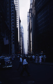
Slide, Robin Boyd, 1956-1957
Robin Boyd developed a close friendship with the founder of the Bauhaus in Weimar Germany, Walter Gropius, who had moved to the USA in the 1930s. Through this connection, Boyd was invited to be the Massachusetts Institute of Technology (MIT) Bemis Professor at the School in the North American academic year 1956-7. Robin and Patricia Boyd, with their youngest daughter Suzy, were based in Cambridge, Massachusetts for the year. Boyd gave some lectures at MIT and he was also invited to give lectures at many other universities, allowing him to travel widely within the USA, especially on the East Coast. This gave him the opportunity to meet architects like Frank Lloyd Wright, Eero Saarinen, Paul Rudolph and many others, and visit the offices of Skidmore, Owings and Merrill, and places like Taliesin and the General Motors Technical Center Detroit. On the way home, the Boyds visited London, Berlin, Paris and Le Corbusier’s Ronchamp Chapel in France.Colour slide in a mount. New York City streetscape: Woolorth Building (1913) in the background, New York, USA. (Architect: Cass Gilbert.)Made in USA / 15 / Wall St Woolworth far down on the right. Emery Roth standard ? 1/2 down rightmit bemis professorship, mit, robin boyd, slide -
Canterbury History Group
Ephemera - "Winson" 1 Winson Green Road Canterbury, 1989
Real Estate advertisement for the sale of "Winson' 1 Winson Green Road Canterbury. Includes coloured photographs of the streetscape and interior and exterior of the house.canterbury, winson green road, winson, paul walker & assoc. pty ltd, woodwards, first national -
 Buninyong & District Historical Society
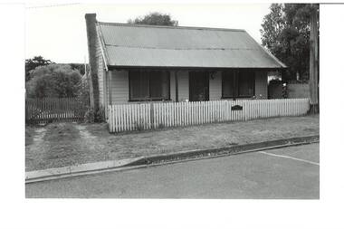
Photograph - Original B/W Photograph, Miner's cottage built on land owned by Thomas Hiscock in Learmonth St west, Buninyong, April 1994
The weatherboard cottage was built in the 1860's on land owned by Thomas Hiscock, the discoverer of gold near Buninyong township.The weatherboard cottage was built in the 1860's on land owned by Thomas Hiscock, the discoverer of gold near Buninyong. It is a good example of a miner's cottage of its era.B/W photo of Miner's cottage, Learmonth St west, Buninyong. Streetscape photo taken in 1993 of a weatherboard building with picket fence.miners cottage, house, building, weatherboard, thomas hiscock, hiscock, buninyong, learmonth st -
 Buninyong & District Historical Society
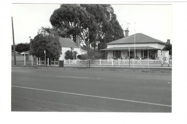
Photograph - B/W photograph, Mr. C. J. Brooks, Former Middleton's Hardware Shop Warrenheip Street Buninyong and residence, 19th April 1994
1994 photograph of early well known Hardware shop and residence associated with the Middleton family.Example of an early weatherboard shop and residence operated by a local familyBlack and white photograph of streetscape, West side of Warrenheip Street North showing weatherboard residence and hardware shop associated with the Middleton familymiddleton family, warrenheip street, hardware shop, building, streetscape, ironmongery, weatherboard, local business -
 Federation University Historical Collection
Photograph- Black and White, Ballarat Streetscape
.3) This photograph was possibly taken from the tower of the Ballarat West Fire Station with Raglan St intersection with Mair St in the foreground and Scots Church, Lydiard Street North on the HorizonThree black and white photographs showing a Ballarat streetscape including houses and a nursery. .2 and .3 are details of .1. .3) features the Albion Hotell ballarat, albion hotel, ballarat west fire brigade, ballarat townscape -
 Wodonga & District Historical Society Inc
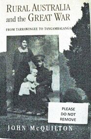
Book - Rural Australia and the Great War - From Tarrawingee to Tangambalanga, John McQuilton, 2001
This publication covers common issues of life in Australia during World War 1, such as recruitment, fundraising, conscription, homecomings and the construction of memorials. However it is unique in that these aspects of war are examined through a focus on rural communities in North Eastern Victoria. The first chapter describes the region and its towns at the outbreak of war, then discusses the fracturing impact of war on different groups within these communities. It paints an interesting social history at a critical time in Australia's development. John Quilton is a native of North Eastern Victoria, having been born in Yackandandah and educated in Tangambalanga and Wodonga. He was a senior member of the Bicentennial History Project at the University of New South Wales, and head of the History and Politics Program at the University of Wollongong.This book consists of 275 pages including photos and a map, as well as an extensive bibliography. The cover depicts a soldier and his family and a country town streetscape on the back.This publication covers common issues of life in Australia during World War 1, such as recruitment, fundraising, conscription, homecomings and the construction of memorials. However it is unique in that these aspects of war are examined through a focus on rural communities in North Eastern Victoria. The first chapter describes the region and its towns at the outbreak of war, then discusses the fracturing impact of war on different groups within these communities. It paints an interesting social history at a critical time in Australia's development. John Quilton is a native of North Eastern Victoria, having been born in Yackandandah and educated in Tangambalanga and Wodonga. He was a senior member of the Bicentennial History Project at the University of New South Wales, and head of the History and Politics Program at the University of Wollongong.world war 1, rural conditions australia 1914, world war 1 social conditions australia, tangambalanga world war 1 -
 Buninyong & District Historical Society
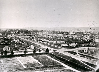
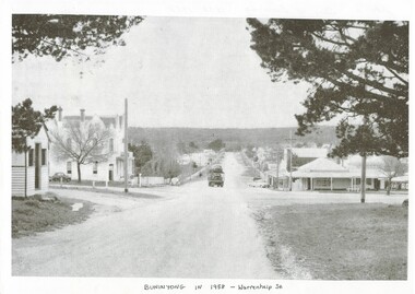
Photograph - Photo of Original Photograph, Warrenheip / Learmonth intersection, looking north up Warrenheip, in 1958, 1995
historic streetscapeB/W photograph, Warrenheip / Learmonth intersection, looking north up Warrenheip, in 1958, Crown Hotel, corner store visible, truck with double layer load of cars heading north."Specially Produced For A.H. Dixon Learmonth St, from east, Buninyong 1543"buninyong, learmonth st., warrenheip st., intersection, crown hotel, corner store -
 Buninyong & District Historical Society
Photograph - Original B/W Photograph, Clive Brooks, Streetscape, looking west down Scott St. from Inglis Street corner, 19/04/1994
B/W photograph, Streetscape, looking west down Scott St. from Inglis Street corner, Uniting Church partially visible on right, Presbytery on left.buninyong, scott st., inglis st., uniting church, presbytery -
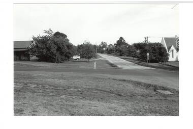
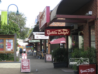
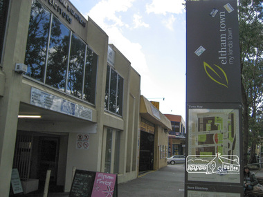
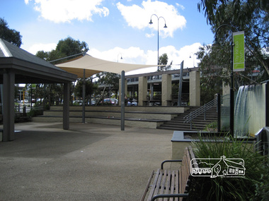 Eltham District Historical Society Inc
Photograph, Liz Pidgeon, Commercial Place, Eltham, 15 April 2011
Streetscape and shop developmentsBorn Digitaleltham, commercial place, shopping centre -
 Eltham District Historical Society Inc
Photograph, Liz Pidgeon, Commercial Place, Eltham, 15 April 2011
Streetscape and shop developmentsBorn Digitaleltham, commercial place, shopping centre -
 Eltham District Historical Society Inc
Photograph, Liz Pidgeon, Commercial Place, Eltham, 15 April 2011
Streetscape and shop developmentsBorn Digitaleltham, commercial place, shopping centre -
 Surrey Hills Historical Society Collection
Photograph, Beatty Street, Mont Albert
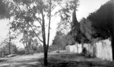
The Lodewyckx family made their home at 3 Beatty Street, Mont Albert coming to the area after staying for six months at 'Medlow', the home of Dr Bull and his family while the latter were overseas. Augustin was in charge of the German Department at Melbourne University starting during the rather difficult days of the 1920s. A black and white photograph of a streetscape. There is a fence in front of a hedge along the right hand side of the photograph. There is a van parked on the left hand side of the photograph. There are many trees in the background.beatty street, mont albert, 1940-1949, lodewyckx family -
Clunes Museum
NATIONAL TRUST AWARD, 2006
SUBMISSION: CLUNES TOURIST & DEVELOPMENT ASSOCIATION PRODUCTION: CTDA MEMBERS TEXT: DR TESS BRADY PHOTOGRAPHY: NEIL NEWITTFOLDER CONTAINING C.D. AND PRINTED AWARD FROM THE NATIONAL TRUST PROVINCIAL VICTORIA HISTORIC TOWNS AWARDS. CATEGORY 1: THE TOWN WITH THE MOST INTACT HERITAGE STREETSCAPE CHARACTERlocal history, documents, awards, town award, ctda -
Glenelg Shire Council Cultural Collection
Souvenir - First Day Cover, c. 1990
Envelope, First Day Cover commemorating Casterton's First Postmaster. White envelope, photo of Casterton streetscape. 41c stamp, cancel stamp, dated 12 July 1990.casterton post -
 Kew Historical Society Inc
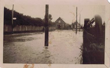
Photograph - Flooded street, 1940-50
View of unknown flooded streetscape.Original, black and white positive of a flooded street, originally believed to have been in Kew, but based on an examination of the history, deemed not to be a location in Kew or Kew East. The flooding is of a T-intersection with a brick church and a house in the background.Inscribed verso: "? Kew / R 774 / VELOX"floods -
Malmsbury Historical Society
Photograph (Item), Copy Of Small Photo Of 3 Men In Street With Traction Engine, Malmsbury pre 1920
People - Ashwell Collection Buildings - Streetscape -
Canterbury History Group
Ephemera - 6 Logan Street Canterbury, {2007}
Real estate advertisement for the sale of "Raasay" c1903 6 Logan Street Canterbury on Saturday 26 August {2007} by Kay & Burton. Includes coloured photographs of the interior, exterior and streetscapecanterbury, logan street, queen anne style, fountains, raasay