Showing 80 items matching "sunbury township."
-
 Hume City Civic Collection
Map, Sunbury Township 1857
... Sunbury Township 1857......Sunbury township...This is a reprint of a 1857 map of the township of Sunbury in the County of Bourke produced by the Public Records Office by courtesy of the Surveyor General in 1978....This is a reprint of a 1857 map of the township of Sunbury....Sunbury Township 1857 Map Map ...This is a reprint of a 1857 map of the township of Sunbury in the County of Bourke produced by the Public Records Office by courtesy of the Surveyor General in 1978.This is a reprint of a 1857 map of the township of Sunbury.sunbury, shire of bulla, sunbury township, 1850s -
 Hume City Civic Collection
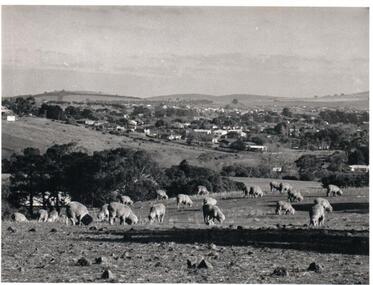
Photograph, Early 1970s
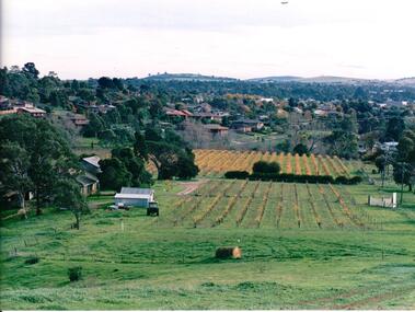
... sunbury township...The photograph was taken when Sunbury township did not extend far beyond Anderson Road to the west and Powlett Street to the east. ...A black and white photograph of a panoramic view of Sunbury township looking west and taken from above the Goonawarra Winery. ...The Paynes housing development can be seen scattered across the hillside between Gap Road and Mitchells Lane. sunbury township goonawarra winery george evans collection A black and white photograph of a panoramic view of Sunbury township looking west and taken from above the Goonawarra Winery. ...The photograph was taken when Sunbury township did not extend far beyond Anderson Road to the west and Powlett Street to the east. The Paynes housing development can be seen scattered across the hillside between Gap Road and Mitchells Lane.A black and white photograph of a panoramic view of Sunbury township looking west and taken from above the Goonawarra Winery. Sheep are grazing on the hilside in the foreground.sunbury township, goonawarra winery, george evans collection -
 Hume City Civic Collection
Photograph, c 1980s
... sunbury township...The photograph although recently taken shows the original settled area in Sunbury, which included Goonawarra Vineyard and Macedon Street which was once the business centre of Sunbury township before the railway was established....A coloured photograph of Sunbury Township looking west from above Jacksons Creek and Goonawarra Winery. ...Hume City Civic Collection 44 Macedon Street Sunbury melbourne The photograph although recently taken shows the original settled area in Sunbury, which included Goonawarra Vineyard and Macedon Street which was once the business centre of Sunbury township before the railway was established. sunbury township mt. holden burke hill francis james goodall barnier john jacksons creek goonawarra winery george evans collection A coloured photograph of Sunbury Township looking west from above Jacksons Creek and Goonawarra Winery. ...The photograph although recently taken shows the original settled area in Sunbury, which included Goonawarra Vineyard and Macedon Street which was once the business centre of Sunbury township before the railway was established.A coloured photograph of Sunbury Township looking west from above Jacksons Creek and Goonawarra Winery. Macedon Street can be seen in the middle distance and Mt. Holden and Burke Hill are across the skyline.sunbury township, mt. holden, burke hill, francis, james goodall, barnier, john, jacksons creek, goonawarra winery, george evans collection -
 Sunbury Family History and Heritage Society Inc.
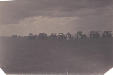
Photograph, Camp in Sunbury township, 1900
... Camp in Sunbury township...A dark sepia photograph of a campsite in an open area with tents and some large horse-drawn vehicles set up. Camp in Sunbury township Photograph ...From information written on the back of the image, this was 'a Dutch camp in township' which was there in 1900. There is no indication as to where the camp actually was.A dark sepia photograph of a campsite in an open area with tents and some large horse-drawn vehicles set up. -
 Hume City Civic Collection
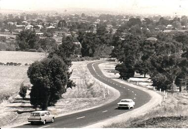
Photograph, Early 1970s
... ...sunbury township...A black and white panoramic view of the eastern approach to Sunbury and the Sunbury township before the road was widened and straightened and the new bridge was built. ...The area on the LHS of the photograph including the two arched stone bridge has been incorporated into a public picnic area. macedon street macedon street road bridge jacksons creek sunbury township george evans collection A black and white panoramic view of the eastern approach to Sunbury and the Sunbury township before the road was widened and straightened and the new bridge was built. ...In the early 1970s the eastern approach to Sunbury was changed. The stone bridge spanning the Jacksons Creek was replaced by a wider concrete structure and dangerous curves were taken out of the road. The area on the LHS of the photograph including the two arched stone bridge has been incorporated into a public picnic area.A black and white panoramic view of the eastern approach to Sunbury and the Sunbury township before the road was widened and straightened and the new bridge was built. There are two cars in the foreground. One is approaching the bridge and the other is leaving Sunbury.macedon street, macedon street road bridge, jacksons creek, sunbury township, george evans collection -
 Sunbury Family History and Heritage Society Inc.
Photograph
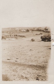
... Sunbury township....A portrait view overlooking Sunbury township taken from a hill above the Goonawarra vineyard at the eastern end of the settlement. ...Sunbury township. Goonawarra Winery A non-digital sepia photograph with a cream border of a portrait view of a rural landscape. ...A portrait view overlooking Sunbury township taken from a hill above the Goonawarra vineyard at the eastern end of the settlement. A non-digital sepia photograph with a cream border of a portrait view of a rural landscape.sunbury township., goonawarra winery -
 Sunbury Family History and Heritage Society Inc.
Photograph, c1920s - 1930s
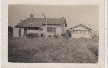
... Sunbury township....In the 1920s a few Californian style homes were built in the township of Sunbury and some of them can still be seen in the town....Sunbury township. Californian Bungalows A non-digital black and white photograph of the rear view of a weatherboard Californian style bungalow built in an open paddock. ...In the 1920s a few Californian style homes were built in the township of Sunbury and some of them can still be seen in the town.A non-digital black and white photograph of the rear view of a weatherboard Californian style bungalow built in an open paddock. The house also has a smaller building on the RHS and an outdoor toilet as well as a double clothes line are in the yard. sunbury township., californian bungalows -
 Sunbury Family History and Heritage Society Inc.
Photograph, 1936
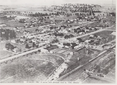
... The aerial view of Sunbury was featured in The Argus newspaper in 1936 in recognition of 100 years of European settlement of the area. It shows the extent of the township...A non-digital black and white aerial photograph with a cream border of the Sunbury township. ...A non-digital black and white aerial photograph with a cream border of the Sunbury township. Photograph ...The aerial view of Sunbury was featured in The Argus newspaper in 1936 in recognition of 100 years of European settlement of the area. It shows the extent of the township in 1936 which extended from the railway line in the west to the Jackson Creek in the east and the Sunbury Asylum in the south and northwards towards Macedon Street. The photograph was taken when Sunbury was a country settlement 25 miles ( 37 kms) from Melbourne. Since the 1980s the area grown rapidly and is now an outer suburb of Melbourne.A non-digital black and white aerial photograph with a cream border of the Sunbury township. SUNBURY 1936 - A SOUVENIR AERIAL PHOTOGRAPH ISSUED BY THE ARGUS.aerial photographs, sunbury, newspaper photographs -
 Hume City Civic Collection
Photograph
... A b/w photograph of a landscape view showing Jackson's Creek with the Sunbury township in the background....Hume City Civic Collection 44 Macedon Street Sunbury melbourne mcmahon landscapes jackson's creek sunbury george evans collection Handwritten on back: McMahon A b/w photograph of a landscape view showing Jackson's Creek with the Sunbury township in the background. Photograph ...A b/w photograph of a landscape view showing Jackson's Creek with the Sunbury township in the background.Handwritten on back: McMahonmcmahon, landscapes, jackson's creek, sunbury, george evans collection -
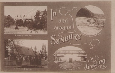 Sunbury Family History and Heritage Society Inc.
Postcard
... A post card with four sepia photographs of interesting sites which can be seen in the Sunbury township. ...A post card with four sepia photographs of interesting sites which can be seen in the Sunbury township. Postcard ...The post card is one of a set that were produced by Chris Christainsen, who had a pharmacy in Sunbury and was also a photographer. The four photos featured on the card are the Rupertswood Mansion, St Mary's Church of England, Jacksons Creek in flood and Sunbury Railway station.The buildings and places featured on the card are of historical significance in the Sunbury town precinct. A post card with four sepia photographs of interesting sites which can be seen in the Sunbury township. IN AND AROUND SUNBURY WITH GREETING. christainsen, chris., rupertswood mansion, st. mary's church of england., jacksons creek, sunbury railway station, post cards -
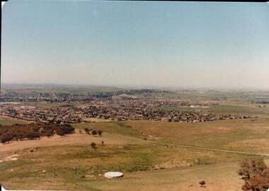 Hume City Civic Collection
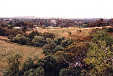
Photograph, early 1980s
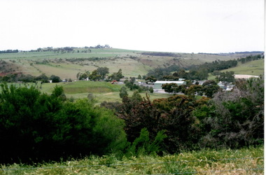
... sunbury township...The settlement at this stage extended along either side of Gap Road for about 0.5 km beyond Elizabeth Drive. sunbury township reservoir road mt. holden sunbury asylum george evans collection A coloured landscape photograph with rounded corners taken from Mt. ...The photograph shows the extent of Sunbury's development to the west of the town in the early 1980s. The settlement at this stage extended along either side of Gap Road for about 0.5 km beyond Elizabeth Drive.A coloured landscape photograph with rounded corners taken from Mt. Holden and looking towards the expanding town of Sunbury. The Melba Avenue drain which flows into Blind Creek is in the foreground. Sheoak Hill, the site of the former Sunbury Asylum is in the middle of the skyline.sunbury township, reservoir road, mt. holden, sunbury asylum, george evans collection -
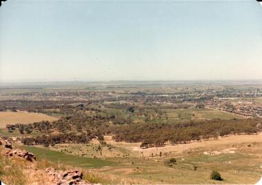 Hume City Civic Collection
Photograph, early 1980s
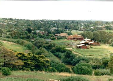
... ...sunbury township...It was situated west of Sunbury and was bounded by Elizabeth Drive, Reservoir Road, Phillip Drive and Stewart's Lane. headland estate mt. holden sunbury township george evans collection A coloured landscape photograph with rounded corners of a view of Sunbury overlooking the Headland Estate before its development. ...The Headland Estate housing development began in the early 1980s. It was situated west of Sunbury and was bounded by Elizabeth Drive, Reservoir Road, Phillip Drive and Stewart's Lane.A coloured landscape photograph with rounded corners of a view of Sunbury overlooking the Headland Estate before its development. There is a rocky outcrop on the LHS of the photograph and a lightly timbered area in the middle distance. Sunbury can be seen in the distance.headland estate, mt. holden, sunbury township, george evans collection -
 Hume City Civic Collection
Photograph, Early 1970s
... sunbury township...Hume City Civic Collection 44 Macedon Street Sunbury melbourne sunbury township macedon street george evans collection A panoramic view of Sunbury looking west. ...A panoramic view of Sunbury looking west.sunbury township, macedon street, george evans collection -
 Hume City Civic Collection
Photograph, late 1980s
... A coloured landscape photograph overlooking Craiglee Winery and vineyard as well as the Sunbury township and its surrounding hills north of the town. ...In 1961 the Carmody family purchased the property and in 1976 re-established the vineyard. wineries vineyards johnstone james stewart carmody patrick 'craiglee' winery george evans collection A coloured landscape photograph overlooking Craiglee Winery and vineyard as well as the Sunbury township and its surrounding hills north of the town. ...'Craiglee' Winery was established by James Stewart Johnstone in 1865 and the property continued to function as a winery until the late 1920s. The vines were uprooted and the property was used for wool and fat lamb production. In 1961 the Carmody family purchased the property and in 1976 re-established the vineyard.A coloured landscape photograph overlooking Craiglee Winery and vineyard as well as the Sunbury township and its surrounding hills north of the town. A roll of hay is in the foreground and a tractor near out buildings is to the LHS of the photograph.wineries, vineyards, johnstone, james stewart, carmody, patrick, 'craiglee' winery, george evans collection -
 Hume City Civic Collection
Photograph
... A coloured landscape photograph overlooking the Jacksons Creek and Sunbury township and showing housing development which is taking place on the horse shore bend also known as blueberry island on the opposite creek bank....Hume City Civic Collection 44 Macedon Street Sunbury melbourne Housing development spread to the banks of the Jacksons Creek at the east end of the town in the late 1970s. jacksons creek blueberry island george evans collection A coloured landscape photograph overlooking the Jacksons Creek and Sunbury township and showing housing development which is taking place on the horse shore bend also known as blueberry island on the opposite creek bank. ...Housing development spread to the banks of the Jacksons Creek at the east end of the town in the late 1970s.A coloured landscape photograph overlooking the Jacksons Creek and Sunbury township and showing housing development which is taking place on the horse shore bend also known as blueberry island on the opposite creek bank.jacksons creek, blueberry island, george evans collection -
Hume City Civic Collection
Photograph
... The woodland area was photographed on the outskirts of the old Sunbury township....Hume City Civic Collection 44 Macedon Street Sunbury melbourne The woodland area was photographed on the outskirts of the old Sunbury township. The landscape featured in this image was typical of Sunbury's surrounds in the 19th and early years of the twentieth century. ...The woodland area was photographed on the outskirts of the old Sunbury township.The landscape featured in this image was typical of Sunbury's surrounds in the 19th and early years of the twentieth century. A copy of a non-digital black and white photograph of an woodland area. Two men with a horse and cart are visible in the image.VIEW OF SUNBURYhorses, drays, trees, c. nettleton -
 Sunbury Family History and Heritage Society Inc.
Photograph, 1935
... The waterfall is in Jacksons Creek downstream from the Sunbury township....Sunbury Global Learning Centre Macedon Street Sunbury melbourne The waterfall is in Jacksons Creek downstream from the Sunbury township. Waterfalls Jacksons Creek sunbury A non-digital black and white photograph with a cream border of a waterfall in a river. ...The waterfall is in Jacksons Creek downstream from the Sunbury township.A non-digital black and white photograph with a cream border of a waterfall in a river. A gnarled tree is growing on the bank and there is a hill in the middle distance.waterfalls, jacksons creek, sunbury -
 Hume City Civic Collection
Photograph
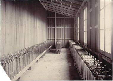
... A section of the former Sunbury Power House in the battery shed with machinery used to generate electricity for the Sunbury township....Hume City Civic Collection 44 Macedon Street Sunbury melbourne A section of the former Sunbury Power House in the battery shed with machinery used to generate electricity for the Sunbury township. sunbury power supply george evans collection Numbers on back: 4� B/W photograph of an interior view of the Sunbury Power Supply Photograph Photograph ...A section of the former Sunbury Power House in the battery shed with machinery used to generate electricity for the Sunbury township.B/W photograph of an interior view of the Sunbury Power SupplyNumbers on back: 4�sunbury power supply, george evans collection -
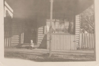 Sunbury Family History and Heritage Society Inc.
Photograph
... Many of the early shops built in the Sunbury township were small weatherboard buildings with a residence attached, similar to the one in the photograph....Sunbury Global Learning Centre Macedon Street Sunbury melbourne Many of the early shops built in the Sunbury township were small weatherboard buildings with a residence attached, similar to the one in the photograph. ...Many of the early shops built in the Sunbury township were small weatherboard buildings with a residence attached, similar to the one in the photograph.A non-digital sepia photograph of a little child seated on a step outside a detached weatherboard building, which is a small shop..shops, sunbury -
Hume City Civic Collection
Photograph, Verna Hommsen, 30th May 1995
... In later years they moved to Aitken Street in Sunbury township....In later years they moved to Aitken Street in Sunbury township. Verna Momkmsen Red Rock Farm Sunbury A non-digital sepia photograph mounted on cream paper of a lady wearing glasses. ...Verna Mommsen is the lady in the photograph, who came to Sunbury from Bright. She and her husband managed Red Rock Farm from 1942. In later years they moved to Aitken Street in Sunbury township.A non-digital sepia photograph mounted on cream paper of a lady wearing glasses. She is standing near a wooden stand, which has flowers on it.verna momkmsen, red rock farm, sunbury -
 Sunbury Family History and Heritage Society Inc.
Photograph
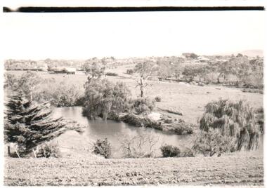
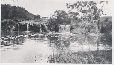
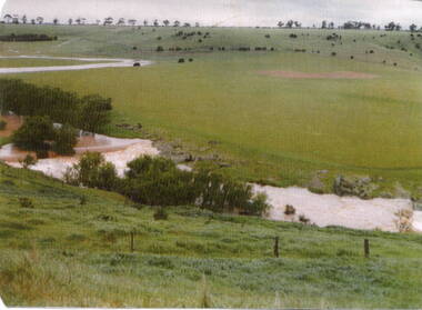
... The photograph is of the Jacksons Creek valley, taken in the vicinity of Mill Falls, near the former 'Springvale' winery, which was downstream from the Sunbury township. John Eadie constructed a mill for producing flour at the falls in 1861....The photograph is of the Jacksons Creek valley, taken in the vicinity of Mill Falls, near the former 'Springvale' winery, which was downstream from the Sunbury township. John Eadie constructed a mill for producing flour at the falls in 1861. ...The photograph is of the Jacksons Creek valley, taken in the vicinity of Mill Falls, near the former 'Springvale' winery, which was downstream from the Sunbury township. John Eadie constructed a mill for producing flour at the falls in 1861.The former 'Springvale' winery was one of a number of wineries that were established in Sunbury in the 19th century.A coloured photograph of a wide open valley with a meandering water course. There is very sparse tree growth on the surrounding hillsides.jacksons creek, mill falls, eadie family, john eadie, sunbury, springvale winery -
 Hume City Civic Collection
Photograph, Mill Falls
... The photograph is of the Jacksons Creek taken in the vicinity of Mill Falls, near the former 'Springvale' winery, which was downstream from the Sunbury township. In 1971 the Shire of Bulla purchased 'Springvale' site and established the town's sewerage plant....Hume City Civic Collection 44 Macedon Street Sunbury melbourne The photograph is of the Jacksons Creek taken in the vicinity of Mill Falls, near the former 'Springvale' winery, which was downstream from the Sunbury township. In 1971 the Shire of Bulla purchased 'Springvale' site and established the town's sewerage plant. ...The photograph is of the Jacksons Creek taken in the vicinity of Mill Falls, near the former 'Springvale' winery, which was downstream from the Sunbury township. In 1971 the Shire of Bulla purchased 'Springvale' site and established the town's sewerage plant.The former 'Springvale' winery was one of a number of wineries that were established in Sunbury in the 19th century.A scanned coloured photograph with rounded corners of a valley with a meandering stream with a small dammed section in the foreground. There is a line of trees across the distant hilltops. mill falls, springvale winery, jacksons creek -
 Sunbury Family History and Heritage Society Inc.
Photograph, 2022
... The site is on the Jacksons Creek downstream from the Sunbury township and close to the former Springvale Winery site. ...The site is on the Jacksons Creek downstream from the Sunbury township and close to the former Springvale Winery site. ...The Sunbury Waterworks Trust operate from the buildings in the photograph. The site is on the Jacksons Creek downstream from the Sunbury township and close to the former Springvale Winery site. In 1971 the Shire of Bulla purchased Springvale and established the town's sewerage plant.A coloured photograph of a number of buildings situated in a wide open valley surrounded by bare hillsides.sunbury waterworks trust, jacksons creek, shire of bulla -
 Sunbury Family History and Heritage Society Inc.
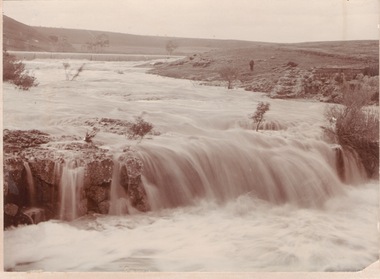
Photograph
... The waterfalls were on the Jacksons Creek downstream from Sunbury township and in the vicinity of a mill which was built on the river bank. ...Sunbury Global Learning Centre Macedon Street Sunbury melbourne The waterfalls were on the Jacksons Creek downstream from Sunbury township and in the vicinity of a mill which was built on the river bank. ...The waterfalls were on the Jacksons Creek downstream from Sunbury township and in the vicinity of a mill which was built on the river bank. The man standing on the riverbank on the RHS of the image is near the remains of Eadie's Mill which was one of the early structures erected in Sunbury.A non-digital sepia photograph mounted on a cream board, of two waterfalls in a flooded river with bare hills on either side. A man is standing near some stone ruins on the RHS of the image.waterfalls, jacksons creek, mill falls -
 Hume City Civic Collection
Photograph, early 1990s
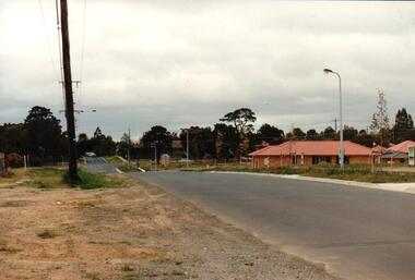
... It was a large housing development built close to Sunbury township....It was a large housing development built close to Sunbury township. housing developments anderson road george evans collection A coloured photograph of one of the last housing developments which took place in the old township area. ...The series of 5 photographs feature different views of the Woodlands Housing Development which opened up land bounded by Gap and Anderson Roads, Cornish Street and Elizabeth Drive in the early 1990s. It was a large housing development built close to Sunbury township.A coloured photograph of one of the last housing developments which took place in the old township area. It is a photograph taken at the north end of Anderson Road looking towards Gap Road. One house has been built and there are a number of 'For Sale' signs of blocks fronting Anderson Road. Guttering and driveways have been formed on one side of the road.housing developments, anderson road, george evans collection -
 Hume City Civic Collection
Photograph, early 1990s
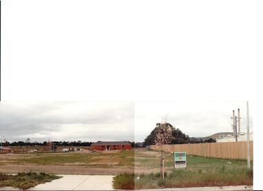
... It was a large housing development built close to Sunbury township....It was a large housing development built close to Sunbury township. housing developments anderson road george evans collection A view of the northern boundary of the Woodlands housing development in Anderson Road. ...The series of 5 photographs feature different views of the Woodlands housing development which opened up land bounded by Gap and Anderson Roads, Cornish Street and Elizabeth Drive in the early 1990s. It was a large housing development built close to Sunbury township.A view of the northern boundary of the Woodlands housing development in Anderson Road. A paling fence divides the estate from the 'Malley' factory, now 'Storage King' which is on the corner of Cornish Street and Anderson Road. A 'For Sale' sign is in the foreground and a partly built house is in the middle distance.housing developments, anderson road, george evans collection -
 Hume City Civic Collection
Photograph, early 1990s
... It was a large housing development built close to Sunbury township....It was a large housing development built close to Sunbury township. housing developments anderson road george evans collection A coloured photograph of a new housing development taken in Anderson Road looking west towards Elizabeth Drive and the leisure centre. ...The series of 5 photographs feature different views of the Woodlands housing development which opened up land bounded by Gap and Anderson Roads, Cornish Street and Elizabeth Drive in the early 1990s. It was a large housing development built close to Sunbury township.A coloured photograph of a new housing development taken in Anderson Road looking west towards Elizabeth Drive and the leisure centre. Some housing construction is in the middle distance.housing developments, anderson road, george evans collection -
 Sunbury Family History and Heritage Society Inc.
Photograph, Sunbury c1873
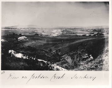
... The photograph is an image of the township of Sunbury taken c1873. The two people sitting on the hillside are overlooking the Jackson Creek from the east end of the town and looking towards Craiglee vineyard. ...A non-digital old black and white scanned photograph overlooking the township of Sunbury. Two people are sitting on a hillside looking towards the town and the distant hills. ...SUNBURY. A non-digital old black and white scanned photograph overlooking the township of Sunbury. ...The photograph is an image of the township of Sunbury taken c1873. The two people sitting on the hillside are overlooking the Jackson Creek from the east end of the town and looking towards Craiglee vineyard. Rupertswod Mansion was not built and there are few houses.This is one of the earliest photograph taken of Sunbury, 37 years after Europeans settled in the area. A non-digital old black and white scanned photograph overlooking the township of Sunbury. Two people are sitting on a hillside looking towards the town and the distant hills. The photograph has a white border Written underneath the photograph VIEW OF JACKSON CREEK SUNBURY.sunbury, craiglee, jackson creek -
 Hume City Civic Collection
Photograph, 1960s
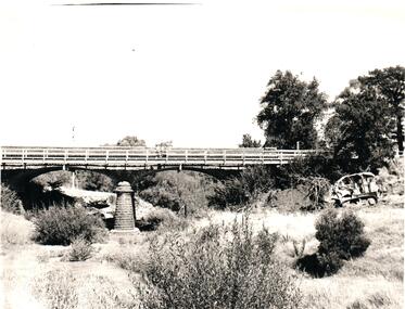
... The two-arched bluestone bridge which spans the Jacksons Creek at the east end of Sunbury township, was built in 1857 and continued to be used as a road bridge on the main Sunbury Road-Macedon Street until the early 1970s when a wider bridge replaced the original bluestone bridge....Hume City Civic Collection 44 Macedon Street Sunbury melbourne The two-arched bluestone bridge which spans the Jacksons Creek at the east end of Sunbury township, was built in 1857 and continued to be used as a road bridge on the main Sunbury Road-Macedon Street until the early 1970s when a wider bridge replaced the original bluestone bridge. bridges bluestone bridges jacksons creek harris thomas lascelles macedon street george evans collection A black and white photograph of a two- arched bluestone bridge which spans a dry creek bed. ...The two-arched bluestone bridge which spans the Jacksons Creek at the east end of Sunbury township, was built in 1857 and continued to be used as a road bridge on the main Sunbury Road-Macedon Street until the early 1970s when a wider bridge replaced the original bluestone bridge.A black and white photograph of a two- arched bluestone bridge which spans a dry creek bed. A bulldozer is on the riverbank on the RHS of the photograph.bridges, bluestone bridges, jacksons creek, harris, thomas lascelles, macedon street, george evans collection -
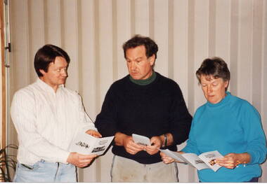 Sunbury Family History and Heritage Society Inc.
Photograph, 21st August 1994
... It was a publication launched on the 21st Au8gust 1994, that highlighted four historic walks around the the old Sunbury township. ...It was a publication launched on the 21st Au8gust 1994, that highlighted four historic walks around the the old Sunbury township. The walks booklet was the first of a number of publications that the Association produced over the years, highlighting Sunbury's history. ...The three people from L-R: Graham Gibb, Trevor Dunn and Wendy Sutherland were members of the Sunbury & District Heritage Association and were attending the launch of a booklet that the Association produced. It was a publication launched on the 21st Au8gust 1994, that highlighted four historic walks around the the old Sunbury township. The walks booklet was the first of a number of publications that the Association produced over the years, highlighting Sunbury's history.A non-digital coloured photograph of a lady and two men discussing a pamphlet.graham gibb, trevor dunn, wendy sutherland, sunbury walks, sunbury & district heritage association