Showing 77 items matching "survey extended"
-
 Marysville & District Historical Society
THE TRIANGLE NEWS-VOL 40 NO 10-MARCH 22 2013
... ...survey extended...marysville victoria australia busy weekend for marysville marysville world's longest lunch world's greatest shave gallipoli park what's on when in march and april the committee of management of the gallipoli park precinct buxton progress assocn community notice taggerty 4 seasons autumn market church notices advertisements murrindindi shire council easter holiday closures rehabilitation of break o'day road glenburn tenders narbethong history group councillor comment marysville community centre carpark & associated streetscape works tenders council looks to reduce its carbon footprint pools prove popular across summer period survey shapes siting and characteristics of bushfire memorial real estate council encourages inclusiveness feedback survey extended mayor's chair lake mountain alpine resort marysville cultural community agm the tower motel australian steelband festival 2013 funded governance training available for community groups national tourism grant to boost marysville industry intrepid triangle bushwalkers THE TRIANGLE NEWS-VOL 40 NO 10-MARCH 22 2013 ...marysville, victoria, australia, busy weekend for marysville, marysville world's longest lunch, world's greatest shave, gallipoli park, what's on when in march and april, the committee of management of the gallipoli park precinct, buxton progress assocn community notice, taggerty 4 seasons autumn market, church notices, advertisements, murrindindi shire council, easter holiday closures, rehabilitation of break o'day road glenburn tenders, narbethong history group, councillor comment, marysville community centre carpark & associated streetscape works tenders, council looks to reduce its carbon footprint, pools prove popular across summer period, survey shapes siting and characteristics of bushfire memorial, real estate, council encourages inclusiveness feedback, survey extended, mayor's chair, lake mountain alpine resort, marysville cultural community agm, the tower motel, australian steelband festival 2013, funded governance training available for community groups, national tourism grant to boost marysville industry, intrepid triangle bushwalkers -
 Warrnambool and District Historical Society Inc.
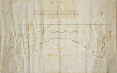
Map - Farnham Survey, 1850s
... In 1843 William Rutledge purchased this Special Survey of 5,120 acres and named it Farnham. This Survey extended from Tower Hill to the Merri River at Dennington. ...In 1843 William Rutledge purchased this Special Survey of 5,120 acres and named it Farnham. This Survey extended from Tower Hill to the Merri River at Dennington. ...This is a map of the Farnham Special Survey. In 1843 William Rutledge purchased this Special Survey of 5,120 acres and named it Farnham. This Survey extended from Tower Hill to the Merri River at Dennington. The map appears to date from the 1850s This early map is of considerable significance as it shows details of the Farnham Special Survey. William Rutledge and his survey are important influences in the development of Warrnambool and district with the establishment of settlements at Killarney, Yangery and Tower Hill.A hand drawn map on waxed paper in brown, black and blue ink. It shows Armstrong's Bay, sea, Crown Land , the names of properties and some roads. It includes a compass direction diagram.farnham special survey, william rutledge, tower hill, dennington, farnham estate -
 Kew Historical Society Inc
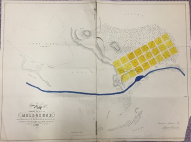
Map, Robert Russell, Map Shewing the Site of Melbourne and the Position of the Huts & Buildings Previous to the Foundation of the Township by Sir Richard Bourke in 1837
... Map shows the first layout of Melbourne by Government surveyor Robert Russell, who accompanied Governor Richard Bourke in 1837. The surveyed blocks extend from present-day Flinders Street to Lonsdale Street, and Spring Street to Spencer Street, with extensive vacant land west to a salt lake (afterwards Batman's Swamp, later drained), north beyond Flagstaff Hill and south towards South Melbourne. ...Kew Historical Society Inc Kew Court House 188 High Street Kew melbourne Map shows the first layout of Melbourne by Government surveyor Robert Russell, who accompanied Governor Richard Bourke in 1837. The surveyed blocks extend from present-day Flinders Street to Lonsdale Street, and Spring Street to Spencer Street, with extensive vacant land west to a salt lake (afterwards Batman's Swamp, later drained), north beyond Flagstaff Hill and south towards South Melbourne. ...Map shows the first layout of Melbourne by Government surveyor Robert Russell, who accompanied Governor Richard Bourke in 1837. The surveyed blocks extend from present-day Flinders Street to Lonsdale Street, and Spring Street to Spencer Street, with extensive vacant land west to a salt lake (afterwards Batman's Swamp, later drained), north beyond Flagstaff Hill and south towards South Melbourne. Vegetation coverage is indicated, and tracks and existing buildings and cultivated land are shown.Printed map was created by Day & Haghe, Lithographers to the Queen, sometime after 1838, when the company received its Royal appointment. Copies of the 1837 map exist in several major map collections in Australia; most are uncoloured. This particular map is the earliest in the Kew Historical Society's map collection. It is a nationally significant artefact. Black and white lithographed map hand-coloured in blue and yellow gouache of the town of Melbourne in 1837. In contrast to the original lithograph, the river and the township blocks are coloured blue and yellow. A similar, partly coloured copy is in the collection of the University of Melbourne.maps - melbourne - 1830s, governor sir richard bourke, robert russell - surveyor, cartography -
 Bendigo Historical Society Inc.
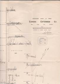
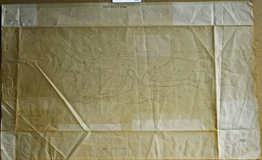
Map - STRUGNELL COLLECTION: UNDERGROUND SURVEY OF MINES, BENDIGO, 29-4-01
... Map, Underground Survey of Mines, Bendigo.Eureka Extended Co., New Chum Line. ...History House 11 Mackenzie Street Bendigo goldfields MAP Bendigo eureka extended co. A>S>Whitelaw Map, Underground Survey of Mines, Bendigo.Eureka Extended Co., New Chum Line. ...Map, Underground Survey of Mines, Bendigo.Eureka Extended Co., New Chum Line. Signed H.A.Whitelaw 29.4.01 Drawing shows mine shaft from 1871 feet to over 3030 feet deep and appears to show samples of connecting horizontal shafts with their respective mineral contents.A>S>Whitelawmap, bendigo, eureka extended co. -
 Port Fairy Historical Society Museum and Archives
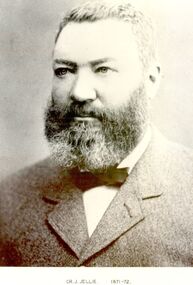
Photograph, Cr J Jellie Shire of Belfast President 1871-72
... He was one of the partners in the auctioneering firm that sold Atkinson’s Crown Special Survey. His municipal activities extended to the Shire of Warrnambool as well as the Borough of Belfast....He was one of the partners in the auctioneering firm that sold Atkinson’s Crown Special Survey. His municipal activities extended to the Shire of Warrnambool as well as the Borough of Belfast. government belfast president portrait shire municipal local-government auctioneer james jellie Black and white portrait Cr J Jellie Shire of Belfast President 1871-72 Photograph Photograph ...Councillor James Jellie came to Melbourne from Ireland in 1841 and moved to Belfast in 1843. he then relocated to Warrnambool in 1849 where he worked as a farmer. He later entered into business as an auctioneer, loan and estate agent and valuation and several large properties passed through his hands. He was one of the partners in the auctioneering firm that sold Atkinson’s Crown Special Survey. His municipal activities extended to the Shire of Warrnambool as well as the Borough of Belfast.Black and white portrait government, belfast, president, portrait, shire, municipal, local-government, auctioneer, james jellie -
 City of Moorabbin Historical Society (Operating the Box Cottage Museum)
Photographs,x3 Colour Early Weatherboard Cottage Cheltenham c1880, 1981
... Henry Dendy , a farmer from Sussex England, purchased 5,120 acres of land in the area of a 'Special Survey 1841' that extended from Brighton bayside North Road, East Boundary Rd to South Road. ...City of Moorabbin Historical Society (Operating the Box Cottage Museum) Joyce Park Jasper Road Ormond melbourne Henry Dendy , a farmer from Sussex England, purchased 5,120 acres of land in the area of a 'Special Survey 1841' that extended from Brighton bayside North Road, East Boundary Rd to South Road. ...Henry Dendy , a farmer from Sussex England, purchased 5,120 acres of land in the area of a 'Special Survey 1841' that extended from Brighton bayside North Road, East Boundary Rd to South Road. This area became known as Dendy's Brighton and as part of the sale 139 emigrant workers arrived in 1842 however Dendy was unable to find work and lodgings for these people. J.B.Were, financier took over the management of the 'Special Survey 1841' area and began to sell and lease allotments. 1850 the Squatter King brothers sold land south of Dendy's 'Special Survey 1841' to Josiah Holloway who sectioned it into 2 acre lots @ £10 each for market gardens - 'Two Acre Village' and Charles Whorral opened a small hotel - 'The Cheltenham Inn' on the main Road - Arthur's Seat Rd, later Point Nepean Rd, now Nepean Highway. Notable settlers who moved into the area were Keys, Charman, Bruton, Le Page, Fairlam, Meeres and 1862 saw the separation from Brighton and the formation of the Mooorabbin Roads Board District. .By 1879 1000settlers were living in 'Cheltenham' serviced by a Post Office with Bank, Mechanics Institute, State School No 84,Keys Hotel, Meeres Store, Sir Thomas Bent ensured the new Railway Line from Caulfield to Mordialloc went through his constituency of Cheltenham 1881 and this changed the development to the bayside area of Cheltenham away from the 'Two Acre Village ' side causing some dissention, However Cheltenham as whole prospered and this house in Pine St is typical of the cottages built c 1890- 1900 in the area. This weatherboard house c 1890-1900 in Pine St Cheltenham is typical of those built for early settler families. Photo taken 1981 by CMHS member 3 x Colour photographs of an early c 1900 weatherboard house in Pine St Cheltenham taken by CMHS member 1981Kodak Aug. 81 / Handwritten Pine St Cheltenhamkeys robert, holloway josiah, king brothers, smith j l; smith mary ann, stanley helen, chaff cutter, horse drawn carts, toll gates brighton, motor cars 1900, steam engines, early settlers, bentleigh, parish of moorabbin, city of moorabbin, county of bourke, moorabbin roads board, shire of moorabbin, henry dendy's special survey 1841, were j.b.; bent thomas, o'shannassy john, king richard, charman stephen, highett william, ormond francis, maynard dennis, market gardeners, vineyards, orchards -
 Bendigo Military Museum
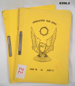
Administrative record - Operation Sunbird - Operation Report Jan 76 - Jun 77, 1 Fd Svy Sqn, 22 Aug 77
... Survey Corps Operation conducted by 1 Fd Svy Sqn during the period Jan 76 - Jun 77. Originally the Operation was to consist of seven phases during the period Nov - Dec 76 to May to Jun 77. The original Operation was extended...Survey Corps Operation conducted by 1 Fd Svy Sqn during the period Jan 76 - Jun 77. Originally the Operation was to consist of seven phases during the period Nov - Dec 76 to May to Jun 77. The original Operation was extended ...Operation Sunbird was a Royal Australian Survey Corps Operation conducted by 1 Fd Svy Sqn during the period Jan 76 - Jun 77. Originally the Operation was to consist of seven phases during the period Nov - Dec 76 to May to Jun 77. The original Operation was extended by the inclusion of Phase 8. .1 is Copy 1 and .2 is Copy 2Yellow Light Cardboard Covered report containing 30 x page report held together with Arnos Fasteners 6356.1 Copy 1, 6356.2 Copy 26356.1 has Army Survey Regiment Library Stamp on front coverroyal australian survey corps, rasvy, fortuna, army survey regiment, army svy regt, asr -
 Bendigo Military Museum
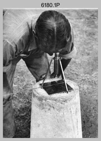
Photograph - RASvy Surveyors in the field, c1950s – 1960s
... It and later models were man-portable systems that improved geodetic survey efficiencies for rapid network extension and densification replacing triangulation with EDM and theodolite traverse sometimes using Bilby Towers to extend line lengths. ...It and later models were man-portable systems that improved geodetic survey efficiencies for rapid network extension and densification replacing triangulation with EDM and theodolite traverse sometimes using Bilby Towers to extend line lengths. ...This is a set of 1photographs of surveyors in the field measuring distances using chains, taking observations using theodolites and operating electric distance measurement equipment. They were probably employed in establishing mapping and geodetic control operations or the surveyors may have been in training. The photos were most likely taken in the 1950s and 1960s. Photos .1P to .6P feature personnel setting up geodetic survey chaining equipment to measure distances. The surveyor in Photo .5P is LTCOL Howard Angus Johnson MBE who served from 1936 to 1954. The RA Svy surveyor in photos .7P to .12P were using a theodolite to take angular measurements. They were usually supported by an observer who recording their readings on a booking form. The surveyor in Photo .10P and .11P is LTCOL Jorge Gruszka, who served from 1955 to 1985. He was CO of the Army Survey Regiment from 1982 to 1985. The surveyor in photo .13P is cutting an identification blaze on a tree using a hammer and chisel. The tellurometer in Photos .14P to .16P was a MRA1 microwave Electronic Distance Measuring instrument (EDM) introduced in 1958. It and later models were man-portable systems that improved geodetic survey efficiencies for rapid network extension and densification replacing triangulation with EDM and theodolite traverse sometimes using Bilby Towers to extend line lengths. The surveyor with the slouch hat is Colonel James ‘Jim’ Leslie Stedman, who served from 1941 to 1978. He was Director of Military Survey from 1975 to 1978 and was appointed as Colonel Commandant (honorary appointment, Retd) of the Royal Australian Survey Corps from 1978 to 1983. Jim Stedman is demonstrating EDM equipment.This is a set of 17 photographs of surveyors in the field measuring distances using chains, taking observations using theodolites and operating electric distance measurement (EDM) equipment. c1950s – 1960s. The photographs were printed on photographic paper and are part of the Army Survey Regiment’s Collection. The photographs were scanned at 300 dpi. .1) - Photo, black & white, c1950s, unidentified personnel using geodetic survey chaining equipment. .2) to .4) - Photo, black & white, c1950s, geodetic survey chaining equipment. .5) – Photo, black & white, c1950s, Jim Stedman using geodetic survey chaining equipment to measure distances. .6) - Photo, black & white, c1950s, Unidentified personnel geodetic survey chaining equipment. .7) – Photo, black & white, mounted on card, c1950s. Unidentified surveyor undertaking observations on a coral reef using a theodolite. .8) – Photo, black & white, c1950, unidentified surveyor undertaking observations with a Tavistock theodolite. .9) – Photo, black & white, mounted on green card, c1950s. Unidentified surveyor undertaking observations using a plane table. .10) – Photo, black & white, c1955, Jorge Gruszka undertaking observations with a theodolite. 7/55 Basic Survey Course Balcombe. .11) – Photo, black & white, c1950s, Jorge Gruszka undertaking observations with a theodolite. .12) – Photo, black & white, c1946-1948, unidentified surveyor undertaking observations with a theodolite to gain control for the mapping of the Snowy Mountain Diversion Scheme. .13) – Photo, black & white, c1950s, unidentified surveyor cutting a blaze in a tree. .14) and .15) – Photo, black & white, c1960s, Jim Stedman demonstrating EDM equipment. .16) – Photo, black & white, c1960s, L to R: Jim Stedman (probably) and unidentified surveyor demonstrating EDM equipment. .17) – Photo, black & white, 1956, Operation Cutlass - Surveyors SPR W. Crane and J.A. Campbell undertaking observations with a theodolite in extreme conditions..1P on back - First Order Chaining Equipment .2P on back - First Order Chaining Equipment .3P on back - Full catenary 1800 – 1960 replaced by EDM .4P on back - First Order Chaining Equipment .5P on back - H.A. Johnson, Benambra baseline? 1st Order Chaining .6P on back - Chaining .7P on front - Difficult observing conditions especially when the tide is in. The station is sighted (sic) on a coral reef. .8P on back - Tavistock. .10P on back of duplicate in Photo Folder 14 – George (sic) Gruszka 7/55 Basic Survey Course Balcomme (sic) 1955/56 .14P and .15P on back - Jim Stedman demonstrating early EDM equipment.royal australian survey corps, rasvy, army survey regiment, army svy regt, fortuna, asr, surveying -
 Bendigo Military Museum
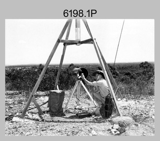
Photograph - Royal Australian Survey Corps Electronic Distance Measuring Equipment Demonstration, c1960s
... The tellurometers of this era were man-portable systems that improved geodetic survey efficiencies for rapid network extension and densification replacing triangulation with EDM and theodolite traverse sometimes using Bilby Towers to extend line lengths. ...The tellurometers of this era were man-portable systems that improved geodetic survey efficiencies for rapid network extension and densification replacing triangulation with EDM and theodolite traverse sometimes using Bilby Towers to extend line lengths. ...This is a set of five photographs of CAPT James ‘Jim’ Leslie Stedman in the field demonstrating the setup of prisms used as electric distance measurement (EDM) receiver reflectors for tellurometer equipment and the sighting of a large surveyor’s light. This equipment was deployed in establishing mapping and geodetic control operations. The photos were most likely taken in the late 1950s or early 1960s. The tellurometers of this era were man-portable systems that improved geodetic survey efficiencies for rapid network extension and densification replacing triangulation with EDM and theodolite traverse sometimes using Bilby Towers to extend line lengths. Jim Stedman later reached the rank of Colonel, was Director of Military Survey from 1975 to 1978 and was appointed as Colonel Commandant (honorary appointment, Retd) of the Royal Australian Survey Corps from 1978 to 1983. Jim Stedman is demonstrating EDM equipment. See item 6180.16P, photos .14) to .16) for more information and photos of Jim Stedman’s EDM demonstration. This is a set of five photographs of a surveyor in the field demonstrating electric distance measurement (EDM) equipment. c1950s – 1960s. The photographs were printed on photographic paper and are part of the Army Survey Regiment’s Collection. The photographs were scanned at 300 dpi. .1) to .2) - Photo, black & white, c1960s, CAPT Jim Stedman demonstrating the sighting of a large surveyor’s light. .3) to .5) – Photo, black & white, c1960s, CAPT Jim Stedman demonstrating EDM prism equipment. .1P to .5P on back – CAPT Stedman EDM Eqpt.royal australian survey corps, rasvy, army survey regiment, army svy regt, fortuna, asr, surveying -
 Orbost & District Historical Society
survey sheet, circa 1870's
... His territory extended from the boundary of Victoria in east Gippsland down to Wilson's Promontory with his headquarters at sale. This map is a useful reference tool. survey Bruce-E.L Snowy-River-C19th Gipps Land Rivers No 32B E.L. ...E.L. Bruce, born in Ireland on July 1,1854, came to Australia in 1854 and joined the Lands Department. He spent most of his service in Gippsland. The journey to Sale then was made by ship to Port Albert and thence on horseback. He began his service in Gippsland as assistant district surveyor and for the last 12 years before retirement he was district surveyor and land officer. His territory extended from the boundary of Victoria in east Gippsland down to Wilson's Promontory with his headquarters at sale.This map is a useful reference tool.A survey map - Sheet No 3 SnowyRiver Survey. This is a copy of the original survey. It shows the properties of W.J.T. Clarke - two in Orbost and one in Newmeralla (sic),. it has a faded, undecipherable red stamp in the bottom right corner.Gipps Land Rivers No 32B E.L. Brucesurvey bruce-e.l snowy-river-c19th -
Federation University Historical Collection
Book - Ledger, Ballarat School of Mines Minutes: 1909-1918, 1909-1918
... Surveying that it be accepted ..." lined pages. 26 November 1909 "..It was decided to accept with thanks an offer of a flagpole and flag made by Mr W. Coltman through the student association. Mr Clegg to be consulted as to its erection. ..." 25 August 1916 "... A very cordial welcome was extended...Surveying that it be accepted ..." lined pages. 26 November 1909 "..It was decided to accept with thanks an offer of a flagpole and flag made by Mr W. Coltman through the student association. Mr Clegg to be consulted as to its erection. ..." 25 August 1916 "... A very cordial welcome was extended ...The Ballarat School of Mines was the first School of Mines in Australia. It is a predecessor institution of Federation University Australia.Hard covered book with leather spine and corners. The minutes of the Ballarat School of Mines Council are handwrittten on the 25 March 1910 "... It was resolved that in the event of the Department of Forestry offering 250 pounds per annum for the instruction of their students at Creswick in Chemistry, Botany, Physics and Surveying that it be accepted ..." lined pages. 26 November 1909 "..It was decided to accept with thanks an offer of a flagpole and flag made by Mr W. Coltman through the student association. Mr Clegg to be consulted as to its erection. ..." 25 August 1916 "... A very cordial welcome was extended to Colonel Bolton, who was present for the first time since his return from Gallipoli. ... " 25 July 1910 "... A letter was received from the staff in reference to Mr Oddie's system of ventilation which he wishes introduced into the School. It was decided to postpone the matter for consideration when funds are available, ..." "... At Colonel Bolton's suggestion, it was decided to inform the Secretary of the Returned Soldiers Association that applications from returned soldiers for free instruction at this School would be favorably considered, and that it would be in the best interests of the movement if applications for admission were received through the Association. ... that Councillors T. Hurley, R. Stephenson, Colonel Bolton and the Principals be appointed as a sub-committee with power to act, in dealing with application from Returned Soldiers. "ballarat school of mines, james bickett, richard t. vale, j.k. dunn, s.e. figgis, samuel figgis, j. lonie, r. maddern, j.y. mcdonald, w.h. middleton, d. mitchell, dr morrison, h.a. nevett, j. ssxton, dr scott, w.h. sewell, j. vikery, g.h. fitches, andrew anderson, g. buchanan, j. dunn, f. herman, j. mitchell, r. scott, r.e. williams, j.d. woolcott, j. pearse, james oddie, shackleton polarizer, forestry school, creswick, b. whittington, ida johnson, j. barber, j. foster, h. hall, w.j. humphries, s. flohm, signwriting, frank tate, colonel bolton, j.b. robinson, alexander peacock, h.h. smith, charles fenner, c.a. hoadley, a.w. steane, j.n. dunn, w.d. hill, c. fenner, g. fitches, r. pearse, a.o. stubbs, daniel walker, w. nixon, t. hurley, r. stephenson, a.e. cutter, w.h. flaey, j.w. gower, j.n. montgomery, ballarat school of mines museum, a.m. lilburne, d. maxwell, d. ronaldson, r.e. tunbridge, j. jolly, j.m. sutherland, frederick martell, w.j. hoare, j.j. brokenshire, r. cutter, g. remfry, j.e. molloy, .stewart bequest, h.b. herbert, j. kean, f. saunders, george swinburne, w.j. humphreys, j. stevens, william baragwanath, richard g. walker, j.f. wiles, w.j. parry, george vincent, m.hannah, repatriation, returned soldiers, william k. bolton, maurice copland, d.v. allen, r.f. barker, a.f. heseltine, r.w. richards, appointment of dick richards, j.f.w. sporn, p.g. brown, h. daykin -
 Eltham District Historical Society Inc
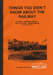
Book, Things You Didn't Know about the Railway: Eltham, Diamond Creek, Wattle Glen, Hurstbridge, 2017
... At the same time another meeting was pressing for the line to be extended to Queenstown (St Andrews). However when detailed surveys were made it was discovered that the only possible route was to Hurstbridge because of the hills. ...At the same time another meeting was pressing for the line to be extended to Queenstown (St Andrews). However when detailed surveys were made it was discovered that the only possible route was to Hurstbridge because of the hills. ...Update of 1st editon by Jock Ryan published in March 2003. 2nd edition (Revised) Nillumbik Historical Society December 2017 Brief history of the agitation and eventual extension and opening of the Hurstbridge Railway line from Eltham to Diamond Creek, Wattle Glen to Hurstbridge, which was opened in June 1912. Includes details of events thereafter including Wattle Day and Railway accidents. Profusely illustrated with black and white photographs from the collection of the Nillumbik Historical Society (Diamond Creek). Agitation for a railway extension began in 1888 when a meeting was held at Arthurs Creek to press for the construction of a railway line from Heidelberg to Kinglake. The Chairman Mr Charles Draper said this was necessary because this was the best fruit growing district in Victoria. Mr Cameron M.P. pointed out that whatever route the line took it would have to follow the Diamond Valley from Eltham. At the same time another meeting was pressing for the line to be extended to Queenstown (St Andrews). However when detailed surveys were made it was discovered that the only possible route was to Hurstbridge because of the hills. In 1912 the railway was opened terminating at Hurstbridge. Bound with orange covers. Text with black and white illustrations. 30 pages.hurstbridge railway line,diamond creek,wattle glen,hurstbridge, nillumbik historical society -
 Bendigo Historical Society Inc.
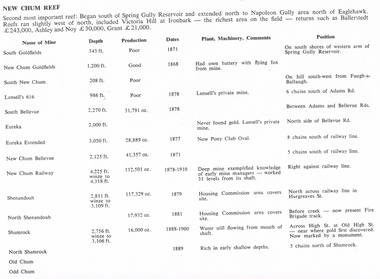
Document - LONG GULLY HISTORY GROUP COLLECTION: NEW CHUM REEF
... Mines mentioned are: South Goldfields, New Chum Goldfields, South New Chum, Lansell's 616, South Bellevue, Eureka, Eureka Extended, New Chum Bellevue, New chum Railway, Shenandoah, North Shenandoah, Shamrock, Old Chum, Little Chum, Young Chum, Craven, Garibaldi, Ellesmere, South Old Chum, New Chum Consolidated, North Ellesmere, New Chum United, Lansell's 222, Lansell's Fortuna, Lazarus, West End, Pioneer, Old Chum, New Chum Victoria, North Old Chum, Lansell's Big 180, Sterry, Victoria Quartz, South Adventure, Great Central Victoria, Ballerstedt No 3, Adventure, Humbold, British and American, Midway, Victoria Consuls, Victoria absorbed by Ironbark, Hercules and Energetic, Victoria Pilot, North Hercules and Energetic, Great Extended Hercules, Pearl, Southern Victoria, Great Extended Victoria, Young Victoria, New Catherine Victoria, Weatern Victoria, New Victoria St Mungo, Surprise, Mystery, Duke of Edinburgh, New St Mungo, Duchess Tribute, South Devonshire, Duchess of Edinburgh, West United Devonshire, Albert, United Devonshire, Saxon and Celt, Hopewell, Prince of Wales, Phoenix, Unicorn, South St Mungo, Princess Alice, Lady Barkly, North Devonshire, Ranzeau, St Mungo, Dublin and Cornwall, Sadowa, Eastwood, Ellenborough, Belmont and Saxeby, Snobs Hill, York and Durham, La bElle, Old Williams United, Arcadia, Williams United, South Catherine, Central Catherine, Catherine United, Murchison, New Franklin, Catherine Extended, Pony Club Oval, Housing Commission, Mt Alvernia Hospital, Fortuna, Lunt, Army Survey Unit, Wybrandt, John Brown Factory, Canterbury, Hercules and Energetic and the North Red White and Blue....History House 11 Mackenzie Street Bendigo goldfields BENDIGO History long gully history group The Long Gully History Group - New Chum Reef Ballerstedt Ashley and Noy Grant South Goldfields New Chum Goldfields South New Chum Lansell's 616 South Bellevue Eureka Eureka Extended New Chum Bellevue New chum Railway Shenandoah North Shenandoah Shamrock Old Chum Little Chum Young Chum Craven Garibaldi Ellesmere South Old Chum New Chum Consolidated North Ellesmere New Chum United Lansell's 222 Lansell's Fortuna Lazarus West End Pioneer Old Chum New Chum Victoria North Old Chum Lansell's Big 180 Sterry Victoria Quartz South Adventure Great Central Victoria Ballerstedt No 3 Adventure Humbold British and American Midway Victoria Consuls Victoria absorbed by Ironbark Hercules and Energetic Victoria Pilot North Hercules and Energetic Great Extended Hercules Pearl Southern Victoria Great Extended Victoria Young Victoria New Catherine Victoria Weatern Victoria New Victoria St Mungo Surprise Mystery Duke of Edinburgh New St Mungo Duchess Tribute South Devonshire Duchess of Edinburgh West United Devonshire Albert United Devonshire Saxon and Celt Hopewell Prince of Wales Phoenix Unicorn South St Mungo Princess Alice Lady Barkly North Devonshire Ranzeau St Mungo Dublin and Cornwall Sadowa Eastwood Ellenborough Belmont and Saxeby Snobs Hill York and Durham La bElle Old Williams United Arcadia Williams United South Catherine Central Catherine Catherine United Murchison New Franklin Catherine Extended Pony Club Oval Housing Commission Mt Alvernia Hospital Fortuna Lunt Army Survey Unit Wybrandt John Brown Factory Canterbury Hercules and Energetic North Red White and Blue Six pages titled New Chum Reef. ...Six pages titled New Chum Reef. No number on the first page, the others are 109 to 113. Mentions location of the reef and some of the rich mines. The mines are mentioned in a table with the Name of Mine; Depth; Production; Dates; Plant, Machinery, Comments and Position. Ballerstedt, Ashley and Noy, and Grant were three of the successful miners. Mines mentioned are: South Goldfields, New Chum Goldfields, South New Chum, Lansell's 616, South Bellevue, Eureka, Eureka Extended, New Chum Bellevue, New chum Railway, Shenandoah, North Shenandoah, Shamrock, Old Chum, Little Chum, Young Chum, Craven, Garibaldi, Ellesmere, South Old Chum, New Chum Consolidated, North Ellesmere, New Chum United, Lansell's 222, Lansell's Fortuna, Lazarus, West End, Pioneer, Old Chum, New Chum Victoria, North Old Chum, Lansell's Big 180, Sterry, Victoria Quartz, South Adventure, Great Central Victoria, Ballerstedt No 3, Adventure, Humbold, British and American, Midway, Victoria Consuls, Victoria absorbed by Ironbark, Hercules and Energetic, Victoria Pilot, North Hercules and Energetic, Great Extended Hercules, Pearl, Southern Victoria, Great Extended Victoria, Young Victoria, New Catherine Victoria, Weatern Victoria, New Victoria St Mungo, Surprise, Mystery, Duke of Edinburgh, New St Mungo, Duchess Tribute, South Devonshire, Duchess of Edinburgh, West United Devonshire, Albert, United Devonshire, Saxon and Celt, Hopewell, Prince of Wales, Phoenix, Unicorn, South St Mungo, Princess Alice, Lady Barkly, North Devonshire, Ranzeau, St Mungo, Dublin and Cornwall, Sadowa, Eastwood, Ellenborough, Belmont and Saxeby, Snobs Hill, York and Durham, La bElle, Old Williams United, Arcadia, Williams United, South Catherine, Central Catherine, Catherine United, Murchison, New Franklin, Catherine Extended, Pony Club Oval, Housing Commission, Mt Alvernia Hospital, Fortuna, Lunt, Army Survey Unit, Wybrandt, John Brown Factory, Canterbury, Hercules and Energetic and the North Red White and Blue.bendigo, history, long gully history group, the long gully history group - new chum reef, ballerstedt, ashley and noy, grant, south goldfields, new chum goldfields, south new chum, lansell's 616, south bellevue, eureka, eureka extended, new chum bellevue, new chum railway, shenandoah, north shenandoah, shamrock, old chum, little chum, young chum, craven, garibaldi, ellesmere, south old chum, new chum consolidated, north ellesmere, new chum united, lansell's 222, lansell's fortuna, lazarus, west end, pioneer, old chum, new chum victoria, north old chum, lansell's big 180, sterry, victoria quartz, south adventure, great central victoria, ballerstedt no 3, adventure, humbold, british and american, midway, victoria consuls, victoria absorbed by ironbark, hercules and energetic, victoria pilot, north hercules and energetic, great extended hercules, pearl, southern victoria, great extended victoria, young victoria, new catherine victoria, weatern victoria, new victoria st mungo, surprise, mystery, duke of edinburgh, new st mungo, duchess tribute, south devonshire, duchess of edinburgh, west united devonshire, albert, united devonshire, saxon and celt, hopewell, prince of wales, phoenix, unicorn, south st mungo, princess alice, lady barkly, north devonshire, ranzeau, st mungo, dublin and cornwall, sadowa, eastwood, ellenborough, belmont and saxeby, snobs hill, york and durham, la belle, old williams united, arcadia, williams united, south catherine, central catherine, catherine united, murchison, new franklin, catherine extended, pony club oval, housing commission, mt alvernia hospital, fortuna, lunt, army survey unit, wybrandt, john brown factory, canterbury, hercules and energetic, north red white and blue -
 Bendigo Historical Society Inc.
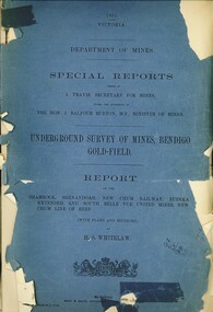
Book - UNDERGROUND SURVEY OF MINES, BENDIGO GOLDFIELD 1901, 1901
... UNDERGROUND SURVEY OF MINES, BENDIGO GOLDFIELD 1901. Report on the Shamrock, Shenandoah, New Chum Railway, Eureka Extended, and South Belle Vue United Mines, New Chum Line of Reef. ...History House 11 Mackenzie Street Bendigo goldfields BENDIGO Hospital gold mining Bendigo goldfields gold mining Shamrock Shenandoah New Chum Railway Eureka Extended and South Belle Vue United Mines New Chum line of Reef. H.S. Whitelaw UNDERGROUND SURVEY OF MINES, BENDIGO GOLDFIELD 1901. ...UNDERGROUND SURVEY OF MINES, BENDIGO GOLDFIELD 1901. Report on the Shamrock, Shenandoah, New Chum Railway, Eureka Extended, and South Belle Vue United Mines, New Chum Line of Reef. With plans and sections.H.S. Whitelawbendigo, hospital, gold mining, bendigo, goldfields, gold mining, shamrock, shenandoah, new chum railway, eureka extended, and south belle vue united mines, new chum line of reef. -
 Bendigo Historical Society Inc.
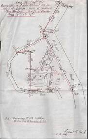
Plan - MCCOLL, RANKIN AND STANISTREET COLLECTION: PLAN OF SURVEY OF DAM SITE, 1941
... Survey of Dam site, Part of Crown Allotment 98 Section C, City of Bendigo, Parish of Sandhurst, County of Bendigo. Signed by Garnet G Birch 1 Feb 1941. 33.5 x 43. Attached is a Copy of Field notes, Dam Site in Crown Allotment 198 Sec. City of Bendigo, Parish of Sandhurst. True Meridian, County of Bendigo, Area 0A 1R 16P. Signed Garnet G Birch, 1/2/1941. Drawn in red and black pen. 20.8 x 33. Both maps are for Deborah Extended...Extended Gold Mining Co. No Liability Plan MCCOLL, RANKIN AND STANISTREET COLLECTION: PLAN OF SURVEY OF DAM SITE ...McColl Rankin & Stanistreet, Plan of Survey of Dam site, Part of Crown Allotment 98 Section C, City of Bendigo, Parish of Sandhurst, County of Bendigo. Signed by Garnet G Birch 1 Feb 1941. 33.5 x 43. Attached is a Copy of Field notes, Dam Site in Crown Allotment 198 Sec. City of Bendigo, Parish of Sandhurst. True Meridian, County of Bendigo, Area 0A 1R 16P. Signed Garnet G Birch, 1/2/1941. Drawn in red and black pen. 20.8 x 33. Both maps are for Deborah Extended Gold Mining Co. No Liabilityorganization, mining, deborah extended gold mining co nl, mccoll rankin & stanistreet, plan of survey of dam site -
 Bendigo Historical Society Inc.
Document - MCCOLL, RANKIN AND STANISTREET COLLECTION: ANGOVE AND CARRS LEASE, DIAMOND HILL, 1935
... Extended. b/ Plan Area Applied For On Lease No. 10103 Ben. By A A Macintosh. Mining District of Bendigo Parish of Mandurang County of Bendigo. Inscriptions: G Birch advises 16/5/35. Survey...Extended. b/ Plan Area Applied For On Lease No. 10103 Ben. By A A Macintosh. Mining District of Bendigo Parish of Mandurang County of Bendigo. Inscriptions: G Birch advises 16/5/35. Survey ...McColl Rankin & Stanistreet, Angove & Carrs Lease, Diamond Hill. a/ Manila folio Markings: Angove & Carrs Lease Diamond Hill. Freed?aus Extended. b/ Plan Area Applied For On Lease No. 10103 Ben. By A A Macintosh. Mining District of Bendigo Parish of Mandurang County of Bendigo. Inscriptions: G Birch advises 16/5/35. Survey made by Assistant he has yet to receive. 10710 W J Angove - Spring Gully PO. Dated August 12th 1933 signed: Garnet G Birch J Victor Buley. c/ Agreement of lease for 1 month with the option of 9 months, followed by the option of purchase between Summerhill Anticlines NL of Adelaide and Angove & Carr at German Gully (Mandurang). Markings: 25/3/13 note by Summerhill Anticline NL. Requests information as to whether or not the Syndicate (E Mann, W Angove & H Irvine, H. Mc……….) desire to take up the options of lease or not. d/ Notice to Shareholders of a meeting in Collins Street Melbourne. 6 March, 1935 to consider proposals of the future of the company. J G Stanfield & Stewart, Manager. e/ Neangar Gold Mining Company NL 6 Month Report 27/2/1935 Business, Director's Report & Financial Report. f/ Report by A J J Moore BCE Mining Engineer, Ramrod Lease, Golden Fleece Mine near Spring Gully Reservoir the most Southern mine being Worked in Bendigo. Lease in on the Carshalton line. Report details the progress of the workings at the mine.organization, business, gold mine, mccoll rankin & stanistreet, angove & carrs lease, diamond hill a a macintosh parish of mandurang county of bendigo w j angove august 12th 1933 summerhill anticlines 6 month report 27/2/1935 golden fleece mine near spring gully reservoir -
 The Beechworth Burke Museum
Photograph, est. 1860-1875
... In 1875, the Rocky Mountain Extended Gold Sluicing Company Ltd was created, utilising the previous Rocky Mountain claim for the area near Lake Sambell. The company employed A.L Martin to survey...The Beechworth Burke Museum Loch Street Beechworth high-country In 1875, the Rocky Mountain Extended Gold Sluicing Company Ltd was created, utilising the previous Rocky Mountain claim for the area near Lake Sambell. The company employed A.L Martin to survey ...In 1875, the Rocky Mountain Extended Gold Sluicing Company Ltd was created, utilising the previous Rocky Mountain claim for the area near Lake Sambell. The company employed A.L Martin to survey an area for a tunnel underneath Beechworth and Johnson Stephens to dig it. The tunnel was built at a rate of 40 feet a month and eventually measured 800 metres. The tunnel was a true accomplishment both in the present and during the 19th century. It was considered to be a marvelous engineering feat. Beechworth is renowned for its hydraulic sluice method of mining. This involved soil being exposed to torrents of water from high-pressure hoses. From 1876 until its closure in 1921, the mine produced an astounding 47,926 ozs of gold. Companies like this were the source of income for many Chinese gold-diggers who sought to make their fortune on the goldfields of Beechworth. During the height of the rush, the town had around 7,000 Chinese inhabitants living on the outskirts of town as they were not permitted to live within Beechworth itself.The search for gold is ingrained into the history of Victoria and therefore, images like this one which portrays an open-cut sluicing site can reveal important information for society and technology for the date when the photograph was taken. This image is of important historical significance for its ability to convey information about sluicing and the methods used to find gold in 1910. It also shows a location where sluicing was undertaken which provides insight into the impact of sluicing on the environment at a time when it was done. This image of the Rocky Mountain mine is historically significant as the mining complex is now non-existent, with the only remains being the tunnel built in 1880 by the company, which was considered one of the greatest engineering feats of the time. The image also provides a first-hand look into the social and cultural networks at play during the 19th century with racial segregation of the Chinese at the 'Chinese Camp', as well as an insight into Beechworth's origins during the Gold Rush.A sepia rectangular photograph printed on matte photographic paper as a postcardReverse: Historic Beechworth / 7792.1 / ROCKY MOUNTAIN MINE / Viewed from the “Chinese Camp”, shown partly in the foreground, we see the central plant of the famous Rocky Mountain Mining Company. This extensive complex, of which nothing remains, was situated between Silver Creek and the present Lake Sambell area. The company was responsible for a tunnel cut through solid bedrock underneath the town of Beechworth and surfacing near the keystone bridge on the Wangaratta side. Completed in 1880 it was declared to be one of the greatest engineering feats in Australia. The tunnel is still basically intact today. / Series by Wooragee Graphics: Historic Beechworth. / COPYRIGHT BURKE MUSEUM / No.72 beechworth, rocky mountain mine, sluicing, gold rush, mining, gold -
 The Beechworth Burke Museum
Photograph - Photograph - Reproduction
... In 1875, the Rocky Mountain Extended Gold Sluicing Company Ltd was created, utilising the previous Rocky Mountain claim for the area near Lake Sambell. The company employed A.L Martin to survey...In 1875, the Rocky Mountain Extended Gold Sluicing Company Ltd was created, utilising the previous Rocky Mountain claim for the area near Lake Sambell. The company employed A.L Martin to survey ...The photograph is a reproduction of a postcard from the Rocky Mountain Mining Company. In 1875, the Rocky Mountain Extended Gold Sluicing Company Ltd was created, utilising the previous Rocky Mountain claim for the area near Lake Sambell. The company employed A.L Martin to survey an area for a tunnel underneath Beechworth and Johnson Stephens to dig it. The tunnel was built at a rate of 40 feet a month and eventually measured 800 metres. The tunnel was a true accomplishment both in the present and during the 19th century. It was considered to be a marvelous engineering feat. Beechworth is renowned for its hydraulic sluice method of mining. This involved soil being exposed to torrents of water from high-pressure hoses. From 1876 until its closure in 1921, the mine produced an astounding 47,926 ozs of gold. Companies like this were the source of income for many Chinese gold-diggers who sought to make their fortune on the goldfields of Beechworth. During the height of the rush, the town had around 7,000 Chinese inhabitants living on the outskirts of town as they were not permitted to live within Beechworth itself.This image of the Rocky Mountain mine is historically significant as the mining complex is now non-existent, with the only remains being the tunnel built in 1880 by the company, which was considered one of the greatest engineering feats of the time. The image also provides a first-hand look into the social and cultural networks at play during the 19th century with racial segregation of the Chinese at the 'Chinese Camp', as well as an insight into Beechworth's origins during the Gold Rush.Black and white rectangular reproduced photograph printed on paperbeechworth, rocky mountain mine, sluicing, gold rush, mining, gold -
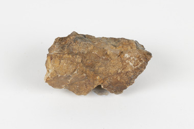 The Beechworth Burke Museum
Geological specimen - Cassiterite
... extended almost one hundred years, to the mid 20th century. Specimens like this would have been used as evidence to justify tin mining operations in the region as an investment. This specimen is part of a larger collection of geological and mineral specimens collected from around Australia (and some parts of the world) and donated to the Burke Museum between 1868-1880. A large percentage of these specimens were collected in Victoria as part of the Geological Survey ...This specimen is Cassiterite in Quartz. Cassiterite is a tin oxide metal that forms in thin crystals which can have a beautiful lustre. Quartz is made of silicon dioxide, also known as silica, and is one of the most common minerals on earth. Cassiterite has been a fundamental source of tin ore for humans throughout history, including today. Tin is an important metal that has a wide variety of human uses in different areas, from dying fabric, to making mirrors, and their most well-known use ‘tin’ cans. Tin cans are primarily made of steel and are coated with tin in order to take advantage of tin’s property of being non-corroding. This is a massive step in the history of food preservation. Tinned food first reached Australia in 1815 with early settlers, and it began to be manufactured here in the 1840s. It was incredibly popular, and was a highly exported product, which would be a contributing factor to the ‘tin mining boom’ of the early 1880s. This specimen was collected at Jingellic, New South Wales, in about 1852. Although the Goldfields of the 1800s are much more well-known, tin mines existed alongside the gold mines which began in the mid 19th century and extended almost one hundred years, to the mid 20th century. Specimens like this would have been used as evidence to justify tin mining operations in the region as an investment. This specimen is part of a larger collection of geological and mineral specimens collected from around Australia (and some parts of the world) and donated to the Burke Museum between 1868-1880. A large percentage of these specimens were collected in Victoria as part of the Geological Survey of Victoria that begun in 1852 (in response to the Gold Rush) to study and map the geology of Victoria. Collecting geological specimens was an important part of mapping and understanding the scientific makeup of the earth. Many of these specimens were sent to research and collecting organisations across Australia, including the Burke Museum, to educate and encourage further study. The Geological Survey of Victoria was headed by British geologist, Alfred Richard Cecil Selwyn (1824-1902), who was responsible for issuing over 60 geological maps during his 17 years as director. These maps were all hand-drawn and coloured and became the benchmark for accuracy for geological mapping. Collecting geological specimens was an important part of mapping and understanding the scientific makeup of the earth. Many of these specimens were sent to research and collecting organisations across Australia, including the Burke Museum, to educate and encourage further study. A fist-sized solid geological specimen made on one half of tin oxide, which is dark grey, and on the other side of silica, which is brown and cream.burke museum, beechworth, geological, geological specimen -
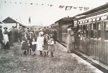 Eltham District Historical Society Inc
Photograph, Hurstbridge Railway Station, Opening Day, 25 June 1912
... At the same time another meeting was pressing for the line to be extended to Queenstown (St Andrews). However when detailed surveys were made it was discovered that the only possible route was to Hurstbridge because of the hills. ...At the same time another meeting was pressing for the line to be extended to Queenstown (St Andrews). However when detailed surveys were made it was discovered that the only possible route was to Hurstbridge because of the hills. ...Despite inclement weather, up to 500 people attended the opening of the Eltham-Hurstbridge railway on 25 June 1912. Local member of parliament Ewen Cameron and Victorian Premier William Watt were present. Agitation for a railway extension began in 1888 when a meeting was held at Arthurs Creek to press for the construction of a railway line from Heidelberg to Kinglake. The Chairman Mr Charles Draper said this was necessary because this was the best fruit growing district in Victoria. Mr Cameron M.P. pointed out that whatever route the line took it would have to follow the Diamond Valley from Eltham. At the same time another meeting was pressing for the line to be extended to Queenstown (St Andrews). However when detailed surveys were made it was discovered that the only possible route was to Hurstbridge because of the hills. In 1912 the railway was opened terminating at Hurstbridge. Digital filerailway station, hurstbridge -
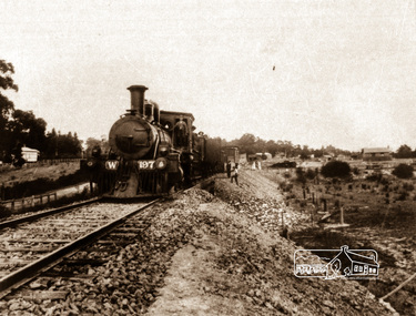 Eltham District Historical Society Inc
Negative - Photograph, Railway construction train hauled by steam locomotive W-197 between Eltham and Hurstbridge, c.1912
... At the same time another meeting was pressing for the line to be extended to Queenstown (St Andrews). However when detailed surveys were made it was discovered that the only possible route was to Hurstbridge because of the hills. ...At the same time another meeting was pressing for the line to be extended to Queenstown (St Andrews). However when detailed surveys were made it was discovered that the only possible route was to Hurstbridge because of the hills. ...The locomotive was built by the American Baldwin Locomotive works in 1880 and was converted to a W class engine by the Phoenix Foundry at Ballarat in 1882. Agitation for a railway extension began in 1888 when a meeting was held at Arthurs Creek to press for the construction of a railway line from Heidelberg to Kinglake. The Chairman Mr Charles Draper said this was necessary because this was the best fruit growing district in Victoria. Mr Cameron M.P. pointed out that whatever route the line took it would have to follow the Diamond Valley from Eltham. At the same time another meeting was pressing for the line to be extended to Queenstown (St Andrews). However when detailed surveys were made it was discovered that the only possible route was to Hurstbridge because of the hills. In 1912 the railway was opened terminating at Hurstbridge. Roll of 35mm colour negative film, 4 stripsKodak Safety 5035steam train, w-197, railway construction, steam locomotive -
 Eltham District Historical Society Inc
Photograph, Railway construction, Wattle Gen, c.1911-12
... At the same time another meeting was pressing for the line to be extended to Queenstown (St Andrews). However when detailed surveys were made it was discovered that the only possible route was to Hurstbridge because of the hills. ...At the same time another meeting was pressing for the line to be extended to Queenstown (St Andrews). However when detailed surveys were made it was discovered that the only possible route was to Hurstbridge because of the hills. ...Agitation for a railway extension began in 1888 when a meeting was held at Arthurs Creek to press for the construction of a railway line from Heidelberg to Kinglake. The Chairman Mr Charles Draper said this was necessary because this was the best fruit growing district in Victoria. Mr Cameron M.P. pointed out that whatever route the line took it would have to follow the Diamond Valley from Eltham. At the same time another meeting was pressing for the line to be extended to Queenstown (St Andrews). However when detailed surveys were made it was discovered that the only possible route was to Hurstbridge because of the hills. In 1912 the railway was opened terminating at Hurstbridge. Roll of 35mm colour negative film, 4 stripsKodak Safety 5035steam train, railway construction, wattle glen -
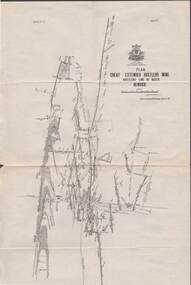
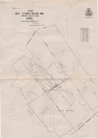
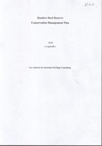 Bendigo Historical Society Inc.
Document - HUSTLERS REEF RESERVE CONSERVATION MANAGEMENT PLAN
... Extended Hustlers Mine site. Leigh McKinnons amendments to the plan are included with the document. History of the site, a physical survey and analysis, comparative analysis, cultural significance and conservation policy are addressed in the document....Extended Hustlers Mine site. Leigh McKinnons amendments to the plan are included with the document. History of the site, a physical survey and analysis, comparative analysis, cultural significance and conservation policy are addressed in the document. ...Conservation management plan (112 pages) prepared by Lee Andrews & Associates, Heritage Consultants, in 2011, for the Hustlers Reef Reserve. The reserve cover the site of the former Great Extended Hustlers Mine site. Leigh McKinnons amendments to the plan are included with the document. History of the site, a physical survey and analysis, comparative analysis, cultural significance and conservation policy are addressed in the document.bendigo, mining, great extended hustlers mine site -
 Bendigo Historical Society Inc.
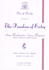
Document - THE FREEDOM OF ENTRY TO ARMY HEADQUARTERS SURVEY REGIMENT, QUEEN ELIZABETH OVAL, 14 June, 1970
... Survey Corps, Queen Elizabeth Oval, Bendigo, Sunday, 14th June, 1970.The Mayor of Bendigo Councillor J C M Jeffrey. Presented by City of Bendigo. Photographs of the Mayor of Bendigo Councillor J C M Jeffrey, Colonel Commandant of the Regiment Brigadier D Macdonald and Commanding Officer Lt Col L B Sprenger, MBE. The City of Bendigo On the 14th day of June 1970 we extend...Survey Corps, Queen Elizabeth Oval, Bendigo, Sunday, 14th June, 1970.The Mayor of Bendigo Councillor J C M Jeffrey. Presented by City of Bendigo. Photographs of the Mayor of Bendigo Councillor J C M Jeffrey, Colonel Commandant of the Regiment Brigadier D Macdonald and Commanding Officer Lt Col L B Sprenger, MBE. The City of Bendigo On the 14th day of June 1970 we extend ...The Freedom of Entry to Army Headquarters Survey Regiment Royal Australian Survey Corps, Queen Elizabeth Oval, Bendigo, Sunday, 14th June, 1970.The Mayor of Bendigo Councillor J C M Jeffrey. Presented by City of Bendigo. Photographs of the Mayor of Bendigo Councillor J C M Jeffrey, Colonel Commandant of the Regiment Brigadier D Macdonald and Commanding Officer Lt Col L B Sprenger, MBE. The City of Bendigo On the 14th day of June 1970 we extend to the Commanding Officer, Officers and Men of the A. H. Q. Survey Regiments Greetings Whereas the Bendigo City Council at a meeting held on the 20th day of April 1970 resolved unanimously that in appreciation of your loyal service to Our Sovereign Our Country and Our City and in recognition of the long and close association existing between the city and the Regiment in which so many of our citizens have been proud to serve, we hereby confer upon such Regiment by this Deed and in perpetuity the privilege honour and distinction of the Freedom of Entry into the City of Bendigo on Ceremonial Occasions in full panoply with Swords drown Bayonets fixed Drums beating Bands playing and Colours Flying. In Witness whereof the Common Seal of the Council was hereto affixed on the 14th day on June 1970 in the presence of J C M Jeffrey Mayor A J Watts Town Clerk. Order Of Ceremony Sunday, 14th June commencing at 1.45pm Bendigo Bands will play selections until 2.10pm, when Bands will move off the arena. The parade of Army Headquarters Survey Regiment Marches into the Queen Elizabeth Oval, Led by the Band of the Royal Australian Armoured Corps . . . Bendigo city council 1969-70 councillors listed . . . Officers Serving with Army Headquaters Survey Regiment on 14th June, 1970, listing . . . A Short History of the Regiment's Association with the City of Bendigo; 1942-1970. On 27th March, 1942, 'Fortuna' was occupied by LHQ Cartographic Company, Australian Survey Corps. . . . Commanding Officers of AHQ Survey Regiment. . . 11 pages.event, official, army survey regiment, the freedom of entry to army headquarters survey regiment royal australian survey corps, queen elizabeth oval, bendigo, sunday, 14th june, 1970.the mayor of bendigo councillor j c m jeffrey. presented by city of bendigo. photographs of the mayor of bendigo councillor j c m jeffrey, colonel commandant of the regiment brigadier d macdonald and commanding officer lt col l b sprenger, mbe. the city of bendigo on the 14th day of june 1970 commanding officer, officers and men of the a. h. q. survey regiments greetings bendigo city council at a meeting 1970 resolved unanimously that in appreciation of your loyal service to our sovereign our country and our city the freedom of entry into the city of bendigo on ceremonial occasions in full panoply with swords drown bayonets fixed drums beating bands playing and colours flying. order of ceremony sunday, 14th june commencing at bendigo bands bands. the parade of army headquarters survey regiment marches into the queen elizabeth oval, royal australian armoured corps . . . bendigo city council 1969-70 councillors listed . . . officers serving with army headquaters survey regiment on 14th june, 1970, listing . . . a short history of the regiment's association with the city of bendigo; 1942-1970. on 27th march, 1942, 'fortuna' was occupied by lhq cartographic company, australian survey corps. . . . commanding officers of ahq survey regiment -
 Bendigo Historical Society Inc.
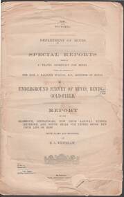
Document - STRUGNELL COLLECTION: UNDERGROUND SURVEY OF MINES: BENDIGO GOLD-FIELD, 1901
... Document, Underground Survey of Mines, Bendigo Gold-Field, Department of Mines, Special Reports on the Shamrock, Shenandoah, New Chum Railway, Eureka Extended, and South Belle Vue United Mines, New Chum Line of Reef, by H.S.Whitelaw.dated 1901.Issued by J.Travis , Secretary for Mines...History House 11 Mackenzie Street Bendigo goldfields DOCUMENT underground survey of mines H.S.Whitelaw -Herbert Staney Whitelaw Document, Underground Survey of Mines, Bendigo Gold-Field, Department of Mines, Special Reports on the Shamrock, Shenandoah, New Chum Railway, Eureka Extended, and South Belle Vue United Mines, New Chum Line of Reef, by H.S.Whitelaw.dated 1901.Issued by J.Travis , Secretary for Mines Document STRUGNELL COLLECTION: UNDERGROUND SURVEY OF MINES: BENDIGO GOLD-FIELD ...Document, Underground Survey of Mines, Bendigo Gold-Field, Department of Mines, Special Reports on the Shamrock, Shenandoah, New Chum Railway, Eureka Extended, and South Belle Vue United Mines, New Chum Line of Reef, by H.S.Whitelaw.dated 1901.Issued by J.Travis , Secretary for Minesdocument, underground survey of mines, h.s.whitelaw -herbert staney whitelaw -
 Bendigo Historical Society Inc.
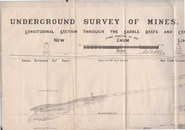
Map - STRUGNELL COLLECTION: NEW CHUM LINE OF REEF, 5/4/01
... Map, Along portion of the New Chum Line, Underground Survey of Mines, Bendigo, Longitudinal Section through the Saddle Reefs and Centre Country. Eureka Extended Co's shaft, New Chum Railway Co's shaft. ...History House 11 Mackenzie Street Bendigo goldfields MAP Bendigo new chum line H.S.Whitelow Map, Along portion of the New Chum Line, Underground Survey of Mines, Bendigo, Longitudinal Section through the Saddle Reefs and Centre Country. Eureka Extended Co's shaft, New Chum Railway Co's shaft. ...Map, Along portion of the New Chum Line, Underground Survey of Mines, Bendigo, Longitudinal Section through the Saddle Reefs and Centre Country. Eureka Extended Co's shaft, New Chum Railway Co's shaft. Surveyed under the supervision of H.Herman, B.C.E., F.G.S., Acting Government Geologist.H.S.Whitelowmap, bendigo, new chum line -
 Bendigo Historical Society Inc.
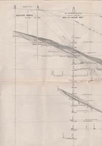
Map - STRUGNELL COLLECTION: HUSTLER'S LINE OF REEFS, BENDIGO, September 1913
... Map, Hustler's Line of Reefs, Great Extended Hustler's Mine, Bendigo, Transverse Section. Plate No. X11 (12). Bulletin No 33 Signed H.A.Whitelaw Underground survey Office Bendigo September 1913 Drawing shows mine shaft to over 3454 feet deep and appears to show samples of connecting horizontal shafts with their respective mineral contents...History House 11 Mackenzie Street Bendigo goldfields MAP Bendigo great extended hustler's mine Underground Survey Office, Bendigo. Map, Hustler's Line of Reefs, Great Extended Hustler's Mine, Bendigo, Transverse Section. ...Map, Hustler's Line of Reefs, Great Extended Hustler's Mine, Bendigo, Transverse Section. Plate No. X11 (12). Bulletin No 33 Signed H.A.Whitelaw Underground survey Office Bendigo September 1913 Drawing shows mine shaft to over 3454 feet deep and appears to show samples of connecting horizontal shafts with their respective mineral contentsUnderground Survey Office, Bendigo.map, bendigo, great extended hustler's mine -
 Bendigo Historical Society Inc.
Map - STRUGNELL COLLECTION: HUSTLER'S LINE OF REEFS, BENDIGO, September 1913
... Map, Hustler's Line of Reefs, Great Extended Hustler's Mine, Longitudinal Section Plate No X111 (13). Bulletin No 33 Signed H.A.Whitelaw Underground survey Office Bendigo September 1913 Drawing shows mine shaft to over 3454 feet deep and appears to show samples of connecting horizontal shafts...History House 11 Mackenzie Street Bendigo goldfields MAP Bendigo great extended hustler's mine Underground Survey Office, Bendigo. Map, Hustler's Line of Reefs, Great Extended Hustler's Mine, Longitudinal Section Plate No X111 (13). ...Map, Hustler's Line of Reefs, Great Extended Hustler's Mine, Longitudinal Section Plate No X111 (13). Bulletin No 33 Signed H.A.Whitelaw Underground survey Office Bendigo September 1913 Drawing shows mine shaft to over 3454 feet deep and appears to show samples of connecting horizontal shaftsUnderground Survey Office, Bendigo.map, bendigo, great extended hustler's mine -
 Bendigo Historical Society Inc.
Map - STRUGNELL COLLECTION: HUSTLER'S LINE OF REEFS, BENDIGO, September 1913
... Map, Hustler's Line of Reefs, Great Extended Hustler's Mine Plan, Plate No. X1 (11). Bulletin No 33 Signed H.A.Whitelaw Underground survey Office Bendigo September 1913....History House 11 Mackenzie Street Bendigo goldfields MAP Bendigo great extended hustler's mine Underground Survey Office, Bendigo. Map, Hustler's Line of Reefs, Great Extended Hustler's Mine Plan, Plate No. ...Map, Hustler's Line of Reefs, Great Extended Hustler's Mine Plan, Plate No. X1 (11). Bulletin No 33 Signed H.A.Whitelaw Underground survey Office Bendigo September 1913.Underground Survey Office, Bendigo.map, bendigo, great extended hustler's mine -
 Bendigo Historical Society Inc.
Map - STRUGNELL COLLECTION: HUSTLER'S LINE OF REEFS, BENDIGO, September 1913
... Map, Hustler's Line of Reefs, Great Extended Hustler's Mine Plan,Plate No X (10).Bulletin No 33 Signed H.A.Whitelaw Underground survey Office Bendigo September 1913 Drawing has a table showing depths of levels...History House 11 Mackenzie Street Bendigo goldfields MAP Bendigo great extended hustler's mine Underground Survey Office, Bendigo. Map, Hustler's Line of Reefs, Great Extended Hustler's Mine Plan,Plate No X (10).Bulletin No 33 Signed H.A.Whitelaw Underground survey Office Bendigo September 1913 Drawing has a table showing depths of levels Map STRUGNELL COLLECTION: HUSTLER'S LINE OF REEFS, BENDIGO. ...Map, Hustler's Line of Reefs, Great Extended Hustler's Mine Plan,Plate No X (10).Bulletin No 33 Signed H.A.Whitelaw Underground survey Office Bendigo September 1913 Drawing has a table showing depths of levelsUnderground Survey Office, Bendigo.map, bendigo, great extended hustler's mine